The end of the Carboniferous ‘icehouse’ world

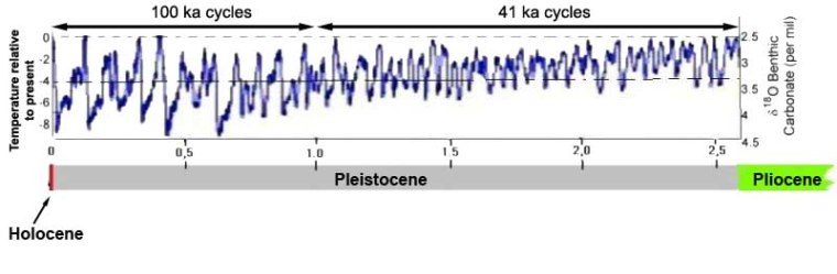
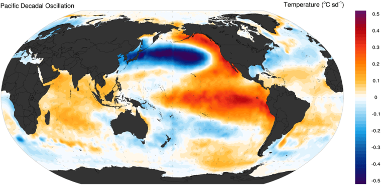
From about 340 to 290 Ma the Earth experienced the longest episode of repeated ice ages of the Phanerozoic. The climate then was similar in many ways to that of the Pleistocene. The South Polar region was then within the Pangaea supercontinent and thus isolated from any warming effect from the surrounding ocean: much the same as modern Antarctica but on a much larger scale. Glaciation extended as far across what became the southern continents and India as did the continental ice sheets of the Northern Hemisphere during Pleistocene glacial maxima. Tropical sedimentary rocks of the time, display evidence for repeated alternations of high and low sea levels that mark cycles of glacial maxima and interglacial episodes akin to those of the Pleistocene. In fact they probably reflect the influence of changes in the Earth’s orbit and geometry of its axis of rotation very similar to those predicted by Milankovich from astronomical factors to explain Pleistocene climatic cycles. At the end of the Carboniferous what was an ‘ice-house’ world changed suddenly to its opposite – ‘greenhouse’ conditions – that persisted through the Mesozoic Era until the later part of the Cenozoic, when Antarctica developed is ice cap and global climate slowly cooled to become extremely cyclical once again.

Sedimentary evidence for global climates 320 Ma ago. As well as the large tracts of glaciogenic sediments, smaller occurrences and examples of polished rock surfaces over which ice had passed show the probable full extent (blue line) of ice sheets across the southern, Gondwana sector of Pangaea (Credit: after Fig 7.3, S104, Earth and Space, ©Open University 2007)

The end of the Carboniferous witnessed the collapse of the vast Equatorial rainforests, which formed the coal deposits that put ‘Carbon’ into the name of the Period. By its end this ecosystem had vanished to result in a minor mass extinction of both flora and fauna. Temperatures rose and aridity set in, to the extent that the latest Carboniferous in the British coalfields is marked by redbeds that presage the spread of desert conditions across the Equatorial parts of Pangaea during the succeeding Permian. A team of researchers based at the University of California at Davis have been studying data pertaining to this sudden change have now published their findings (Chan J. and 17 others 2022. Marine anoxia linked to abrupt global warming during Earth’s penultimate icehouse. Proceedings of the National Academy of Sciences, v. 119, article e2115231119; DOI: 10.1073/pnas.2115231119). They used carbon-, oxygen- and uranium isotopes, together with proxies for changes in atmospheric CO2 concentrations, to model changes in the carbon cycle in the Late Carboniferous of China.

Changes in uranium isotopes within marine carbonates are useful indicators of the amount of oxygen available in ocean water at the sea floor. Between 304 and 303.5 Ma ago oxygen content declined by around 30%, the peak of this anoxia being at 303.7 Ma. This occurred about 100 ka after atmospheric CO2 had risen to ~700 parts per million (ppm) from around 350 ppm in the preceding 300 ka, as marked by several proxies.  The authors suggest that the lower ‘baseline’ for the main greenhouse gas marked an extreme glacial maximum. Changes in the proportions of 18O relative to ‘lighter’ 16O in fossil shells suggest that sea-surface temperatures increased in step with the doubling of the greenhouse effect. At the same time there was a major marine transgression as sea level rose. This would have been accompanied by a massive increase in low density freshwater in surface ocean water derived from melting of Pangaea’s ice cap. The team suggests that the freshened surface layer could not sink to carry oxygen to deeper levels, thereby creating anoxic conditions across an estimated 23% of the global seafloor, and thus toxic ‘death zones’ for marine organisms.

One possibility for this sudden rise of atmospheric CO2 is a massive episode of volcanism, perhaps a large igneous province, but there is scanty evidence for that at the end of the Carboniferous. A coinciding sharp decrease in δ13C  in carbonate shells suggests that the excess carbon dioxide probably had an organic origin. So a more plausible hypothesis is massive burning on the continental surface. In the tropics, the huge coals swamps would have contained vast amounts of peat-like decayed vegetable matter as well as living green vegetation. How might that have caught fire? The peat precursor to Carboniferous coal deposits derived from photosynthesis on an unprecedented, and never repeated, scale during tens of million years of thriving tropical rain forest during that Period. This built up atmospheric oxygen levels to about 35%, compared with about 21% today. Insects, whose maximum size is governed by their ability to take in oxygen through spiracles in their bodies, and by the atmospheric concentration of oxygen, became truly huge during the earlier Carboniferous. The more oxygen in the air, the greater the chance that organic matter will catch fire. In fact wet vegetation can burn if oxygen levels rise above 25%. At the levels reached in the Carboniferous huge wildfires in forests and peatlands would have been inevitable. Evidence that huge fires did occur comes from the amount of charcoal found in Carboniferous coal seams, which reach 70% compared with the 4 to 8 % in more recent coals. They may have been ignited by lightning strikes or even spontaneous combustion if decay of vegetation generated sufficient heat, as sometimes happens today in wet haystacks or garden compost heaps.  But how in a short period around 304 Ma could 9 trillion tons of carbon dioxide be released in this way. The preceding  glacial super-maximum, like glacial maxima of the Pleistocene, may have been accompanied by decreased atmospheric humidity: this would dry out the vast surface peat deposits.

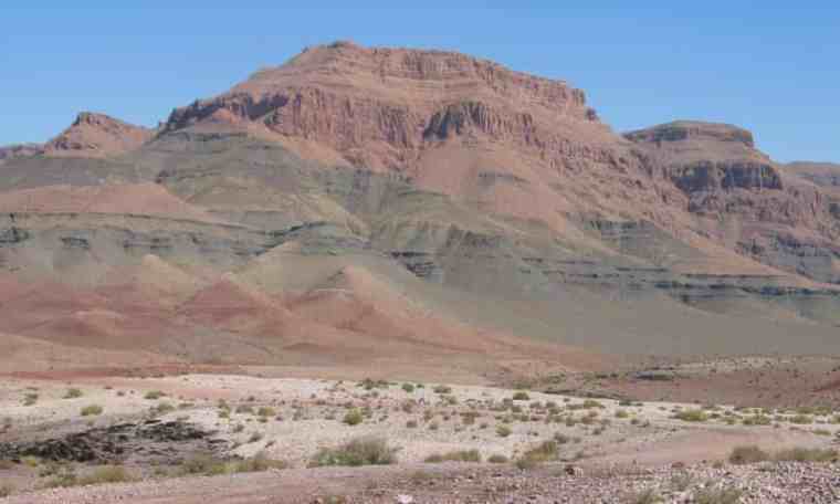
The succeeding Permian is famous for its extensive continental redbeds, and so too those of the Triassic. They are red because sediment grains are coated in the iron oxide hematite (Fe2O3). As on Mars, the redbeds are a vast repository for oxygen sequestered from the atmosphere by the oxidation of dissolved Fe2+ to insoluble Fe3+. This had been going on throughout the Permian, the nett result being that by 250 Ma atmospheric oxygen content has slumped to 16% and remained so low for another 50 million years. Photosynthesis failed to resupply oxygen against this inorganic depletion, and there are few coal deposits of Permian or Triassic age: for about 100 Ma Earth ceased to have green continents.

See also: Carbon, climate change and ocean anoxia in an ancient icehouse world. Science Daily, 2 May 2022. 

Evidence for an early Archaean transition to subduction

Modern plate tectonics is largely driven by slab-pull: a consequence of high-pressure, low-temperature metamorphism of the oceanic crust far from its origin at an oceanic ridge. As it ages, basaltic crust cools, become increasingly hydrated by hydrothermal circulation of seawater through it and its density increases. That is why the abyssal plains of the ocean floor are so deep relative to the shallower oceanic ridges where it formed. Due to the decrease in the Earth’s internal heat production by decay of radioactive isotopes, once oceanic lithosphere breaks and begins to descend high-P low-T metamorphism transforms the basaltic crust to a denser form: eclogite, in which the dense, anhydrous minerals garnet and sodium-rich pyroxene (omphacite) form. Depending on local heat flow, the entire oceanic slab may then exceed the density of the upper mantle to drag the plate downwards under gravity. Metamorphic reactions of any P-T regime creates minerals less capable of holding water and drive H2O-rich fluids upwards into the overriding lithosphere, thus inducing it to partially melt. Magmas produced by this create volcanism at the surface, either at oceanic island arcs or near to continental margins, depending on the initial position of the plate subduction.

A direct proof of active subduction in the geological record is the presence of eclogite and related blueschists. Such rocks are unknown before 2100 Ma ago (mid-Palaeoproterozoic of the Democratic Republic of Congo) but there are geochemical means of ‘sensing’ plate tectonic control over arc magmatism (See: So, when did plate tectonics start up? February 2016).  The relative proportions of rare-earth elements in ancient magmatic rocks that make up the bulk of continental crust once seemed to suggest that plate tectonics started at the end of the Archaean Eon (~2500 Ma). That method, however, was quite crude and has been superseded by looking in great detail at the geochemistry of the Earth’s most durable mineral: zircon (ZrSiO4), which began more than two decades ago. Minute grains of that mineral most famously have pushed back the geological record into what was long believed to be half a billion years with no suggestion of a history: the Hadean. Zircon grains extracted from a variety of ancient sediments have yielded U-Pb ages of their crystallisation from igneous magma that extend back 4.4 billion years (Ga) (see: Pushing back the “vestige of a beginning”;January 2001).  

Though simple in their basic chemical formula, zircons sponge-up a large range of other trace elements from their parent magma. So, in a sense, each tiny grain is a capsule of their geochemical environment at the time they crystallised. In 2020 Australian geochemists presented the trace-element geochemistry of 32 zircons extracted from a 3.3 Ga old sedimentary conglomerate in the Jack Hills of Western Australia, which lie within an ancient continental nucleus or craton. They concluded that those zircons mainly reveal that they formed in andesitic magmas, little different from the volcanic rocks that are erupted today above subduction zones. From those data it might seem that some form of plate tectonics has been present since shortly after the Earth’s formation. Oxygen-isotope data from zircons are useful in checking whether zircons had formed in magmas derived directly from partial melting of mantle rocks or by recycling of crustal magmatic rocks through subduction. Such a study in 2012 (see: Charting the growth of continental crust; March 2012) that used a very much larger number of detrital zircon grains from Australia, Eurasia, North America, and South America seemed, in retrospect, to contradict a subduction-since-the-start view of Earth dynamics and crust formation. Instead it suggested that recycling of crust, and thus plate-tectonic subduction, first showed itself in zircon geochemistry at about 3 Ga ago.

Detailed chemical and isotopic analysis of zircons using a variety of instruments has steadily become faster and cheaper. Actually finding the grains is much easier than doing interesting things with them. It is a matter of crushing the host rock to ‘liberate’ the grains. Sedimentary hosts that have not been strongly metamorphosed are much more tractable than igneous rocks. Being denser than quartz, the dominant sedimentary mineral, zircon can be separated from it along with other dense, trace minerals, and from them in turn by various methods based on magnetic and electrical properties. Zircons can then be picked out manually because of their distinctive colours and shapes. A tedious process, but there are now several thousand fully analysed zircons aged between 3.0 to 4.4 Ga, from eleven cratons that underpin Australia, North America, India, Greenland and southern Africa. The latest come from a sandstone bed laid down about 3.31 Ga ago in the Barberton area of South Africa (Drabon, N. et al. 2022. Destabilization of Long‐Lived Hadean Protocrust and the Onset of Pervasive Hydrous Melting at 3.8 GaAGU Advances, v. 3, article e2021AV000520; DOI: 10.1029/2021AV000520). The authors measured lutetium (Lu), hafnium (Hf) and oxygen isotopes, and concentrations of a suite of trace element in 329 zircons from Barberton dated between 3.3 to 4.15 Ga.

A schematic model of transition from Hadean-Eoarchaean lid tectonics to a type of plate tectonics that subsequently evolved to its current form, based on hafnium isotope data in ancient zircons (credit: Bauer et al. 2020; Fig 3)

The Hf isotopes show two main groups relative to the values for chondritic meteorites (assumed to reflect the composition of the bulk Earth). Zircons dated between 3.8 and 4.15 Ga all show values below that expected for the whole Earth. Those between 3.3 and 3.8 Ga show a broader range of values that extend above chondritic levels. The transition in data at around 3.8 Ga is also present in age plots of uranium relative to niobium and scandium relative to ytterbium, and to a lesser extent in the oxygen isotope data. On the basis of these data, something fundamentally changed in the way the Earth worked at around 3.8 Ga. Nadja Drabon and colleagues ascribe the chemical features of Hadean and Eoarchaean zircons to an early protocrust formed by melting of chemically undepleted mantle. This gradually built up and remained more or less stable for more than 600 Ma, without being substantially remelted through recycling back to mantle depths. After 3.8 billion years ago, geochemical signatures of the zircons start showing similarities to those of zircons derived from modern subduction zones. Hf isotopes and trace-element geochemistry in 3.6 to 3.8 Ga-old  detrital zircons from other cratons are consistent with a 200 Ma transition from ‘lid’ tectonics (see: Lid tectonics on Earth; December 2017) to the familiar tectonics of rigid plates whose basalt-capped lithosphere ultimately returns to the mantle to be involved in formation of new magmas from which continental crust stems. Parts of plates bolstered by this new, low density crust largely remain at the surface.

While Drabon et al. do provide new data from South Africa’s Kaapvaal craton, their conclusions are similar to earlier work by other geochemists based on data from other area (e.g. Bauer, A.M. et al. 2020. Hafnium isotopes in zircons document the gradual onset of mobile-lid tectonicsGeochemical Perspectives Letters, v. 14; DOI: 10.7185/geochemlet.2015), which the accompanying figure illustrates.

See also: Earliest geochemical evidence of plate tectonics found in 3.8-billion-year-old crystal. Science Daily, 21 April 2022. 3.8-Billion-Year-Old Zircons Offer Clues to When Earth’s Plate Tectonics Began. SciNews, 26 April 2022

Evidence for oldest microbes from Arctic Canada

Among the oldest known rocks are metamorphosed pillow basalts on Nuvvuagittuk Island in Quebec on the east side of Hudson Bay, Canada. They contain red and orange, iron-rich sediments probably formed by hydrothermal activity associated with sea water passing through hot basalts. The ironstones are made of silica in the form of jasper (SiO2) and carbonates that are coloured by hematite (Fe2O3). This rock sequence is cut by silica-rich intrusive igneous rocks dated between 3750 and 3775 Ma: a minimum, Eoarchaean age for the sequence. This is roughly the same as the age of the famous Isua supracrustal rocks of West Greenland, but dating of the basalts using the samarium–neodymium method suggested that they formed in the Hadean about 4300 Ma ago, which would make them by far the oldest known rocks. However, that date clashes with a zircon U-Pb age of 3780 Ma for associated metasedimentary mica schists: a still ‘live’ controversy. The ironstones have been suggested to contain signs of life, in the form of minute tubes and filaments similar to those formed in modern hydrothermal vents by iron-oxidising bacteria (see: Earliest hydrothermal vent and evidence for life, March 2017). If that can be proven this would push back the age of the earliest known life by at least 300 Ma and maybe far more if the Hadean Sm-Nd age is confirmed

The Nuvvuagittuk material has recently been re-examined by its original discoverers using a variety of advanced microscope techniques (Papineau, D. et al 2022. Metabolically diverse primordial microbial communities in Earth’s oldest seafloor-hydrothermal jasper. Science Advances, v. 8, article 2296; DOI: 10.1126/sciadv.abm2296.). The most revealing of these involve two very-high resolution imaging systems: X-ray micro-tomography and electron microscopy armed with a focused ion beam that repeatedly shaves away 200 nm of rock from a sample. Both build up highly detailed 3-D images of any minute structures within a sample. The techniques revealed details of twisted filaments, tubes, knob-like and branching structures up to a centimetre long. While the first three could possibly have some inorganic origin, a ‘comb-like’ branch, likened to a moth’s antenna, has never been known to have formed by chemical reactions alone.

An image of hematite tubes from microfossils discovered in hydrothermal vent precipitates in the Nuvvuagittuk ironstones, reconstructed from X-ray and ion-beam micro-tomography (credit: Matthew Dodd, UCL)

All the structures are formed from hematite within a silica or carbonate (mainly calcite CaCO3 and ankerite Ca(Fe,Mg,Mn)(CO3)2) matrix. Some of the hematite (dominated by Fe3+) contains significant amounts of reduced Fe2+. The structures also contain tiny grains of graphite (C), phosphate (apatite Ca5(PO4)3(F,Cl,OH)) and various metal (Mn, Co, Cu, Zn, Ni, Cd) sulfides. The presence of graphite obviously suggests – but does not prove – a biological origin. However, all Phanerozoic jaspers formed from hydrothermal fluids contain undisputed organic material and appear little different from these ancient examples. Filaments, tubes and comb-like structures are displayed by various iron-oxidising bacteria found living in modern sea-floor hydrothermal vent systems. The sulfur isotopes in metal sulfides suggest their formation in an environment with vanishingly low oxygen content. Carbon isotopes in graphite are more enriched in light 12C relative to 13C than those in associated carbonates, a feature produced by living organic processes today. Patterns in plots of rare-earth elements (REE) from the Nuvvuagittuk jaspers are similar to those from modern examples and suggest high-temperature interactions between sea water and basaltic igneous rocks.

It is clear from the paper just how comprehensively the team of authors have considered and tested various biotic and abiotic options for the origin of the features found in the Nuvvuagittuk jasper samples. They conclude that they probably do represent an ancient microbial ecosystem associated with sea-floor hydrothermal vents; a now widely supported scenario for the origin of life on Earth. But what metabolic processes did the Nuvvuagittuk microbes use? Their intimate association with Fe3+ oxides that contain some reduced Fe2+ suggests that they exploited chemical ‘energy’ from oxidation reactions that acted on Fe2+ dissolved in hydrothermal fluids. This would have been impossible by inorganic means because of the very low oxygen content of seawater shown by the sulfur isotopes in associated sulfide minerals. Iron oxidation and precipitation of iron oxide by organic processes must have involved dissociation of water to yield the necessary oxygen and loss of electrons from available Fe2+, a process used by modern deep-water bacteria that depends on the presence of nitrates. That can power the metabolism of inorganic carbon dissolved in water as, for instance, bicarbonate ions and water to yield cell-building carbohydrates: a form of autotrophy. There may have been other metabolic routes, such as reducing dissolved sulfate ions to sulfur, as suggested by the association of metal sulfides. If the sea floor was shallow enough to be lit CO2 and water may have been converted to carbohydrates by a form of photosynthesis that does not release oxygen, analogous to modern purple bacteria.

There may have been considerable biodiversity in the Nuvvuagittuk ecosystem. So despite its vast age – it may have been active only 300 Ma after the Earth formed, if the oldest date is verified – it has to be remembered that a great many earlier evolutionary steps, both inorganic and organic, must have been accomplished to have allowed these organisms to exist. The materials do not signify the origin of life, but life that was chemically extremely sophisticated: far more so than anything attempted so far in laboratories to figure out the tricks performed by natural inorganic systems. DNA and RNA alone are quite a challenge!

See also: Video by authors of the paper (YouTube) Diverse life forms may have evolved earlier than previously thought. ScienceDaily, 13

Conditions that may have underpinned the ‘Cambrian Explosion’

Geologists of my generation leaned that the earliest signs of abundant and diverse animal life were displayed by an extraordinary assemblage of fossils in a mudstone exposure high on a ridge in the Rocky Mountains of British Columbia. The Burgess Shale lagerstätte, or ‘site of exceptional preservation’, was discovered by Charles Walcott in 1909. It contained exquisite remains, some showing signs of soft tissue, of a great range of animals, many having never before been seen. Though dated at 509 Ma (Middle Cambrian) it was regarded for much of the 20th century as the sign of a sudden burgeoning from which all subsequent life had evolved: the Cambrian Explosion. Walcott only scratched the surface of its riches, its true wonders only being excavated and analysed later by Harry Whittington and his protégé Simon Conway Morris of Cambridge University. Their results were summarised and promoted in one of the great books on palaeontology and evolutionary biology, Wonderful Life (1989) by Steven Jay Gould.

Harbingers of animal profusion first appear around 635 Ma in the Late Neoproterozoic as the Ediacaran Fauna, with the oldest precursors turning up around a billion years ago in the Torridonian Sandstone Formation of northern Scotland. The evolutionary links between them and the Cambrian Explosion are yet to be documented, as creatures of the Ediacaran remain elusive in the earliest Phanerozoic rocks. As regards the conditions that promoted the explosion of animal faunas, the Burgess Shale is a blank canvas, for its riches were not preserved in situ, but had drifted onto deep, stagnant ocean floor to be preserved in oxygen-poor muds that enabled their intricate preservation. The animals could not have lived and evolved without abundant oxygen: what that environment was is not recorded by Walcott’s famous stratigraphic site.

Artistic impression of the Chengjian Biota

China, it has emerged, offers a major clue from around 40 lagerstätten in Chengjian County, Yunnan. They are not only older (518 Ma) than the Burgess Shale but contain 27 percent more faunal diversity: 17 phylums and more than 250 species. Since the discovery of the Chengjian Biota in the first decade of the 21st century palaeontologists have, understandably, been preoccupied by describing its riches in hundreds of scientific papers. The nature of the ecosystem has remained as obscure as that of the Burgess Shale, largely due to the exposed host rocks (laminated siltstones and mudstones) having been weathered. They are superficially similar to the Burgess Shale. In March 2022, 10 scientists working at laboratories in China, Canada, Switzerland and the UK published the results of their painstaking sedimentological investigation of a core dilled through through the entire fossiliferous sequence (Salih, F. and 9 others 2022. The Chengjiang Biota inhabited a deltaic environment. Nature Communications, v. 13, article 1569; DOI: 10.1038/s41467-022-29246-z).

Reconstruction of the near-shore deltaic environment in which the Chengjian Biota lived and evolved. Several rock types and the sedimentary processes that probably formed them shown in ‘cores’ (Credit: Salih et al. Figure 3)

The unweathered core displays a variety of tiny sedimentary structures. These include cross laminations formed by migrating ripples, occasional fine sandstones that include signs of burrowing, graded bedding formed by minor turbidity currents, hummocks formed by back and forth water flow, ripples formed by flow in a single direction and small channels. Unlike the Burgess Shale, the fine-grained Chengjian sediments seem to have been deposited in environments that were far from stagnant and deep. They most closely resemble the offshore parts of the delta of a predominantly muddy river, subject to occasional floods and storms and characterised by large and rapid accumulation of mud and silt by dense sediment-loaded river water flowing down a gently sloping seabed into clearer seawater. That the sediment supply was full of nutrients and oxygen is reflected by small organisms living in burrows. The high-quality preservation of fossils in some layers can be attributed to sudden influxes of freshwater into their marine habitat during storms, so that they were killed in place. Such a near-shore environment, full of nutrients and oxygen but subjected to repeated geochemical and physical stresses, can explain adaptive radiation and evolution at a fast pace. Clearly, that is by no means a full explanation of the Cambrian Explosion, but offers sufficient insight for research to proceed fruitfully.

See also: Modern Animal Life Could Have Origins in a Shallow, Nutrient-Rich Delta, SciTechDaily, 23 March 2022.

Lower-mantle blobs may reveal relics of event going back to the Hadean

The World-Wide Standardised Seismograph Network (WWSSN) records the arrivals of waves generated by earthquakes that have passed through the Earth’s interior. There are two types of these body waves: S- or shear waves that move matter at right angles to their direction of movement; compressional or P-waves that are a little like sound waves as materials are compressed and expanded along the direction of movement. Like sound, P-waves can travel through solids, liquids and gases. Since liquids and gases are non-rigid they cannot sustain shearing, so S-waves only travel through the solid Earth’s mantle but not its liquid outer core. However, their speed is partly controlled by rock rigidity, which depends on the temperature of the mantle; the hotter the lower the mantle’s rigidity.

Analysis of the S-wave arrival times throughout the WWSSN from many individual earthquakes enables seismologists to make 3-D maps of how S-wave speeds vary throughout the mantle and, by proxy, the variation of mantle rigidity with depth. This is known as seismic tomography, which since the late 1990s has revolutionised our understanding of mantle plumes and subduction zones, and also the overall structure of the deep mantle. In particular, seismic tomography has revealed two huge, blob-like masses above the core-mantle boundary that show anomalously low S-wave speeds, one beneath the Pacific Ocean and another at about the antipode beneath Africa: by far the largest structures in the deep mantle. They are known as ‘large low-shear-wave-velocity provinces’ (LLSVPs) and until recently they have remained the enigmatic focus of much speculation around two broad hypotheses: ‘graveyards’ for plates subducted throughout Earth history; or remnants of the magma ocean thought to have formed when another protoplanet impacted with the early Earth to create the Moon about 4.4 billion years ago.

Three-dimensional rendition of seismic tomography results beneath Africa. Mantle with anomalously low S-wave speeds is show in red, orange and yellow. The faint grey overlay represents the extent of surface continental crust today – Horn of Africa at right and Cape Town at the lower margin – the blue areas near the top are oceanic crust on the floor od the Mediterranean Sea. (Image credit: Mingming Li/ASU)

Qian Yuan and Mingming Li of Arizone State University, USA have tried to improve understanding of the shapes of the two massive blobs (Yuan, Q. & Li, M. 2022. Instability of the African large low-shear-wave-velocity province due to its low intrinsic density. Nature Geoscience, v. 15  DOI: 10.1038/s41561-022-00908-3) using advanced geodynamic modelling of the seismic tomography. Their work reveasl that the Pacific LLSVP extends between 500 to 800 km above the core-mantle boundary. Yet that beneath Africa reaches almost 1000 km higher, at 1300 to 1500 km. Both of them are less rigid and therefore hotter than the surrounding mantle. In order to be stable they must be considerably denser than the rest of the mantle surrounding them. But, because it reaches much higher above the core, the African LLSVP is probably less dense than the Pacific one. A lower density suggests two things: the African blob may be less stable; the two blobs may have different compositions and origins.

Both the Pacific Ocean floor and the African continent are littered with volcanic rocks that formed above mantle plumes. The volcanic geochemistry above the two LLSVPs differs. African samples show signs of a source enriched by material from upper continental crust, whereas those from the Pacific do not. Yuan and Li suggest that the enrichment supports the ‘plate graveyard’ hypothesis for the African blob and a different history beneath the Pacific. The 3-D tomography beneath Africa (see above) shows great complexity, perhaps reflecting the less stable nature of the LLSVP. Interestingly, 80 % of the pipe-like African kimberlite intrusions that have brought diamonds up from mantle depths over that last 320 Ma formed above the blob.

But why are there just two such huge blobs of anomalous material that lie on opposite sides of the Earth rather than a continuous anomaly or lots of smaller ones? The subduction graveyard hypothesis is compatible with the last two distributions. In a 2021 conference presentation the authors suggest from computer simulations that the two blobs may have originated at the time of the Moon’s formation after a planetary collision (Yuan, Q. et al. 2021. Giant impact origin for the large low shear velocity provinces. Abstracts for the 52nd Lunar and Planetary Science Conference: Lunar and Planetary Institute, Houston). Specifically, they suggest that the LLSVPs originated from the mantle of the other planet (Theia) after its near complete destruction and melting, which sank without mixing through the magma ocean formed by the stupendous collision. Yet, so far, no geochemists have been bold enough to suggest that there are volcanic rocks of any age that reveal truly exotic compositions inherited from deep mantle material with such an origin. If Theia’s mantle was dense enough to settle through that of the Earth when both were molten, it would be sufficiently anomalous in its chemistry for signs to show up in any melts derived from it. There again, because of a high density it may never have risen in plumes to source any magma that reached the Earth’s surface …

Note added later: Simon Hamner’s Comment about alternative views on seismic tomography has prompted me to draw attention to something I wrote 19 years ago

Signs of massive hydrocarbon burning at the end of the Triassic

One of the ‘Big Five’ mass extinctions occurred at the end of the Triassic Period (~201 Ma), whose magnitude matches that of the more famous end-Cretaceous (K-Pg) event. It roughly coincided with the beginning of break-up of the Pangaea supercontinent that was accompanied by a major episode of volcanism preserved in the Central Atlantic Magmatic Province (CAMP). Eastern North America, West Africa and northern South America reveal scattered patches of CAMP flood basalts, swarms of dykes and large intrusive sills. Like all mass extinctions, that at the Triassic-Jurassic boundary left a huge selection of vacant or depleted ecological niches ready for evolution to fill by later adaptive radiation of surviving organisms. Because it coincided with continental break-up and drift, unlike other such events, evolution proceeded in different ways on the various wandering land masses and in newly formed seas (see  an excellent animation of the formation and break-up of Pangaea – move the slider to 3 minutes for the start of break-up). The Jurassic was a period of explosive evolution among all groups of organisms. The most notable changes were among marine cephalopods, to give rise to a bewildering variety of ammonite species, and on land with the appearance and subsequent diversification of dinosaurs.

Pangaea at the end of the Triassic (top) and in Middle Cretaceous times (Credit: screen shots from animation by Christopher Scotese)

Many scientists have ascribed the origin of these events to the CAMP magmatic activity and the release of huge amounts of methane to trigger rapid global warming. In October 2021 one group focused on a special role for the high percentages of magma that never reached the surface and formed huge intrusions that spread laterally in thick sedimentary sequences to ‘crack’ hydrocarbons to their simplest form, CH4 or methane. A sedimentary origin of the methane, rather than its escape from the mantle, is indicated by the carbon-isotope ‘signature’ of sediments deposited shortly after the Tr-J event. The lighter isotope 12C rose significantly relative to 13C, suggesting an organic source – photosynthesis selectively takes up the lighter isotope.

By examining the element mercury (Hg) in deep ocean sediments from a Tr-J sedimentary section now exposed in Japan, scientists from China, the US and Norway have added detail to the methane-release hypothesis (Shen, J et al. 2022. Mercury evidence for combustion of organic-rich sediments during the end-Triassic crisis. Nature Communications, v. 13, article 1307; DOI:10.1038/s41467-022-28891-8). The relative proportions of Hg isotopes strongly suggest that the mercury had been released, as was the methane, from organic-rich sediments rather than from the CAMP magmas (i.e. ultimately from the mantle) through gasification and then burning at the surface.

The hypothesis is enlivened by a separate study (Fox C.P. et al. 2022. Flame out! End-Triassic mass extinction polycyclic aromatic hydrocarbons reflect more than just fire. Earth and Planetary Science Letters, v. 584, article 117418; DOI: 10.1016/j.epsl.2022.117418) that sees magmatic heating as being not so important. Calum Fox and colleagues at Curtin University, Western Australia analysed sediments from a Triassic-Jurassic sedimentary sequence near the Severn Bridge in SW England, focusing on polycyclic hydrocarbons in them. Their results show little sign of the kinds of organic chemical remnants of modern wildfires. Instead they suggest a greater contribution from soil erosion by acid rain that increased input of plant debris to a late Triassic marine basin

See also: How a major volcanic eruption paved the way for the rise of the dinosaurs Eureka Alert 23 March 2022;  Soil erosion and wildfire: another nail in coffin for Triassic era. Science Daily, 21 March 2022

‘Smoking gun’ for Younger Dryas trigger refuted

In 2018 airborne ice-penetrating radar over the far northwest of the Greenland revealed an impact crater as large as the extent of Washington DC, USA beneath the Hiawatha Glacier. The ice surrounding it was estimated to be younger than 100 ka. This seemed to offer a measure of support for the controversial hypothesis that an impact may have triggered the start of the millennium-long Younger Dryas episode of frigidity (12.9 to 11.7 ka). This notion had been proposed by a group of scientists who claimed to have found mineralogical and geochemical signs of an asteroid impact at a variety of archaeological sites of roughly this age in North America, Chile and Syria. A new study of the Hiawatha crater by a multinational team, including the original discoverers of the impact structure, has focussed on sediments deposited beyond the edge of the Greenland ice cap by meltwater streams flowing along its base. (Kenny, G.G. et al. 2022. A Late Paleocene age for Greenland’s Hiawatha impact structure. Science Advances, v.8, article eabm2434; DOI: 10.1126/science.eabm2434).

Colour-coded subglacial topography from airborne radar sounding over the Hiawatha Glacier of NW Greenland (Credit: Kjaer et al. 2018; Fig. 1D)

Where meltwater emerges from the Hiawatha Glacier downstream of the crater there are glaciofluvial sands and gravels that began to build up after 2010 when rapid summer melting began, probably due to global warming. As luck would have it, the team found quartz grains that contained distinctive planar features that are characteristic of impact shock. They also found pebbles of glassy impact melts that contain clasts of bedrock, further grains of shocked quartz and tiny needles of plagioclase feldspar that crystallised from the melt. Also present were small grains of the mineral zircon (ZrSiO4), both as pristine crystals in the bedrock clasts and porous, grainy-textured grains showing signs of deformation in the feldspathic melt rock. So, two materials that can be radiometrically dated are available: feldspars suitable for the 40Ar/39Ar method and zircons for uranium-lead (U-Pb) dating. The feldspars proved to be about 58 million years old; i.e. of Late Palaeocene age. The pristine zircon grains from bedrock clasts yielded Palaeoproterozoic U-Pb ages (~1915 Ma), which is the general age of the Precambrian metamorphic basement that underpins northern Greenland. The deformed zircon samples have a very precise U-Pb age of 57.99±0.54 Ma. There seems little doubt that the impact structure beneath the Hiawatha Glacier formed towards the beginning of the Cenozoic Era.

During the Palaeocene, Northern Greenland was experiencing warm conditions and sediments of that age show that it was covered with dense forest. The group that since 2007 has been advocating the influence of an impact over the rapid onset of the Younger Dryas acknowledges that the Hiawatha crater cannot support their view. But they have an alternative: an airburst of an incoming projectile. Although scientists know such phenomena do occur, as one did over the Tunguska area in Siberia on the morning of 30 June 1908. Research on the Tunguska Event has discovered  geochemical traces that may implicate an extraterrestrial object, but coincidentally the area affected is underlain by the giant SIberian Traps large igneous province that arguably might account for geochemical anomalies. Airbursts need to have been observed to have irrefutable recognition. Two posts from October 2021 – A Bronze Age catastrophe: the destruction of Sodom and Gomorrah? and Wide criticism of Sodom airburst hypothesis emerges – suggest that some scientists question the data used repeatedly to infer extraterrestrial events by the team that first suggested an impact origin for the Younger Dryas.

See also: Voosen, P, 2022. Controversial impact crater under Greenland’s ice is surprisingly ancient. Science, v. 375, article adb1944;DOI: 10.1126/science.adb1944

New book on geology and landscape of the Britsh Lake District

I don’t often review books on Earth-logs, but one that is pending publication may interest readers (Ian Francis, Stuart Holmes and Bruce Yardley 2022. The Lake District: Landscape and Geology. Marlborough: The Crowbrook Press; ISBN: 078 0 7198 4011 1). Ian Francis urged me to create Earth Pages, the predecessor to Earth-logs. One good turn deserves another, but this is a very good book. Unlike nearly all area-specific geoscientific books it is not primarily a guidebook. Instead it uses the internationally famous Lake District as a means of teaching how to fathom what a landscape represents. In this case, one with a history going back half a billion years, involving closure of an ocean, destruction of a mountain chain and sediment deposition in a ‘shallow, inland sea’. The last couple of million years or so of cycles of glaciation and river erosion have sculpted its present form. Finally, it became the home range of human hunter gatherers, once the ice had melted away around 10 thousand years ago. Britain’s first stone-age tillers and herders colonised its lower elevations, followed by miners and metal smelters, Roman, Viking and Anglo Saxon invaders and settlers. Its beauty and complexity have inspired poets and artists, and they in turn have drawn in more visitors per km2 than perhaps any other National Park on Earth, and far more per annum than its indigenous population.

Cover of The Lake District: Landscape and Geology

Ian, Stuart and Bruce lace their book with some of the best landscape images of the Lake District that I have come across, which invite you to read the text. The Lake District is pitched at a level that anyone can understand, with a minimum of jargon and a pleasant style. Basic geological concepts are covered in separate ‘boxes’, where the main thread requires them and for those who want a little more science. Geology being an observational science, there is some emphasis on indicators of natural processes, such as elliptical drumlins whose sculpting by flowing ice aligns their long axes, and exotic boulders made of rocks only present miles away whose presence suggests the source of the ice that had moved them. Solid rock outcrops in the Lakes are products of many Earth processes, both internal and at the former surface. There are granitic rocks that intruded through once volcanic and sedimentary rocks. Their internal features tell the rocktypes apart, such as the layering of sediments, often cleaved and folded by deformation. and the lack of structure in granite that cuts the layering, yet imparts new minerals to the older marine rocks as a result of igneous heating to very high temperatures.

Most of the geological concepts raised in the main text are amplified by narratives of seven field trips; provided the reader physically walks through them. And why shouldn’t they? Each of them involves only a few kilometres of gentle walking from parking spaces on metalled roads.  They cover all the solid geology, from the regionally oldest rocks, the Early-Ordovician, deep-water Skiddaw Slates; upwards in geological time through the varied products of later Ordovician volcanism and marine sediments; the thick Silurian mudstones and silts; and the youngest and structurally simplest shallow-marine Carboniferous limestone. The sediments all contain fossils and the volcanics are full of evidence of the environment onto which they poured – an oceanic island arc. A simple story is unveiled by all, such as following a track on the flanks of Blencathra, a hill in the Northern Fells. From slates with cleavage formed by compressive forces acting on muds; to a point where new minerals have grown in them through later heating; then to where heat was so intense that the slates came to resemble igneous rocks; and finally outcrops of a granite whose much later intrusion as magma explains the simple sequence. All the trips are like that: not too much to take in, but enough to hammer home the various rudiments of geology.

Britain was where the modern Earth sciences were largely forged. But that was in the absence of complete exposure of all the solid rock that underpins it. What lies between outcrops is the modern natural world and a diversity of ecosystems to which The Lake District also draws attention. Even professional geologists get bored to tears by trudging unendingly over nothing but rock. They enjoy flowers, trees, birds, streams and tarns with fish as a relief. Some of the text also taught me about oddities created by Cumbrian farmers: bields, which are shelters for shepherds and sheep; washfolds where sheep used to be gathered and cleaned prior to shearing, and lots more about the unique upland farming culture of Cumbria. I hope the book proves physically durable, for it will surely find its way into secondary-school and first-year undergraduate field trips. It is also ideal for any family aiming at a fortnight’s holiday in the Lakes, but wondering what to do. The book will get well-thumbed and wet – the one drawback of the Lake District is its annual rainfall, averaging 3.3 metres! Go in April, May or early June to escape the worst of it and that of tourists, and to see its ecology at its best. I’m giving my complimentary copy to my grandchildren, because I get annoyed when they complain of boredom!

End-Cretaceous mass extinction occurred in northern spring

This post’s title seems beyond belief for an event that occurred 66 million years ago: how can geologists possibly say that with any conviction? The claim is based on fossil fishes found in the Late Cretaceous Hell Creek Formation of North Dakota (see: A bad day at the end of the Cretaceous. April, 2019), described in a paper published on 1 April 2019. The horizon that displays all the classic evidence for an impact origin for the K-Pg extinction is a freshwater sediment laid down by a surge into a river system: the upstream result of the mega-tsunami driven by the Chicxulub impact in the Gulf of Mexico. Amongst much else it contains intact marine ammonites – the last of their kind – and freshwater paddlefish and sturgeon. The fishes are preserved exquisitely, with no sign of scavenging. Parts of their gills are clogged with microscopic spherules made of impact glass. They are pretty good ‘smoking guns’ for an impact, and are accompanied by dinosaur remains – an egg with an embryo, hatchlings and even a piece of skin.

A group of scientists from the Netherlands, Sweden, Belgium and the UK examined thin sections of the fishes’ bones (During, M.A.D. et al. 2022. The Mesozoic terminated in boreal springNature online publication, 23 February 2022; DOI: 10.1038/s41586-022-04446-1). These revealed growth layers that show lines of arrested growth (LAGs) separated by thicker layers. Such LAGs in modern paddlefish and sturgeon bones may indicate conditions of low food availability in winter, most growth being during warmer times of year. Each bone that was examined has only a thin outer zone of accelerated growth following its last LAG. So it seems that each specimen died in the Northern Hemisphere spring. This was confirmed by variations within the cyclic zonation of the relative proportions of carbon isotopes 13C and 12C, expressed as δ13C. In the LAGs δ13C is lower than in the thicker zones, which is consistent with decreased prey availability in winter, but see below.

Thin sections of fish bones from the K-Pg boundary layer in the Hell Creek Formation, showing lines of arrested growth marked by red arrowheads. The outermost (top) LAGs are succeeded by only a thin zone of accelerated growth during their last weeks of the fishes’ lives (credit: During et al., Fig. 2)

The paper by During et al. follows one with very similar content from the same deposit that was published about 12 weeks earlier (DePalma, R.A., et al. 2021. Seasonal calibration of the end-cretaceous Chicxulub impact event. Nature Science Reports, v. 11, 23704; DOI: 10.1038/s41598-021-03232-9). Yet During et al. do not refer to it, despite acknowledging DePalma’s guidance in the field and his granting access to his team’s specimens: maybe due to poor communications … or maybe not. DePalma et al. note thatmodern sturgeons are able to spend winters in the sea, which may also explain the low δ13C in the LAGs, as well as decreased prey availability does. They also examined damage by leaf-mining insects in fossil leaves at the site, which supports the springtime extinction hypothesis. Another study in DePalma et al. is the size range of newly hatched fish of three different Families that are founds as fossils in the K-Pg deposit. By comparing them with the growth histories of closely-related modern hatchlings they conclude that perhaps late spring to early summer is implied. Whatever, both papers go on to discuss the implications of their basic conclusions. Spring is a particularly sensitive time for the life cycles of many organisms; i.e. annual reproduction and newborns’ early growth. But some groups of egg-laying animals, such as perhaps dinosaurs, require longer incubation periods than do others, e.g. birds, and may be more vulnerable to rapid environmental change. That may explain the demise of the dinosaurs while their close avian relatives, or at least some of them, survived.  Yet the season in the Southern Hemisphere when the Chicxulub impact occurred would have been autumn. That may go some way towards explaining evidence that ecological recovery from mass extinction in the southern continents seems to have been faster. Almost certainly, the impact would have induced a double climatic whammy: warming in its immediate aftermath followed by global cooling plus a shutdown of photosynthesis as dust clouds enveloped the planet. Then there is the issue of contamination by potentially toxic compounds raised by Chicxulub. The K-Pg boundary seems likely to run and run as a geoscientific story more than four decades since it was first proposed.

See also: Sample, I. 2022. Springtime asteroid ramped up extinction rates, say scientists. The Guardian, 23 September 2022.

Did earliest modern humans in Europe share a cave with Neanderthals?

The cave of Grotte Mandrin in the Rhône Valley, France. (Credit: Slimak et al Fig 1c)

Since 1999 a cave (Grotte Mandrin) on the west flank of the lower Rhône valley in sothern France has been revealing archaeological remains from 3 metres of sediment that can be divided into 12 distinct layers (Slimak, L. and 22 others 2022. Modern human incursion into Neanderthal territories 54,000 years ago at Mandrin, France. Science Advances, v. 8, article eabj9496; DOI: 10.1126/sciadv.abj9496). Tens of thousands of objects have been recovered, mostly from a layer just below midway in the sequence, which is dominated by small (<1 cm), ‘standardised’ stone points that are also found at other sites in the local area. This veritable industry – dubbed the ‘Neronian’ from the nearby Grotte de Néron – seems to have been focussed hereabouts. Older artefacts in layers F and G are considered to be Mousterian, that is generally ascribed to late Neanderthals. Horse, bison and deer bones suggest that these were the main source of animal protein for the cave’s occupants. The site also contained a few objects that show simple decoration. The way in which the Neronian points were produced resembles the working of similar artefacts in Lebanon by anatomically modern humans (AMH) about 45 ka ago; so it is possible that the technology had spread westward with the earliest AMH migrants into Europe. Yet precise radiocarbon and optically stimulated luminescence dating of the Grotte Mandrin site suggests that the sediment accumulated between 84 to 44 thousand years ago. The Mousterian/Neanderthal objects occur in layers F and G between 79 and 57 ka, whereas the Neronian layer E spans 56.8 to 51.7.

Grotte Mandrin has yielded very few hominin remains, except for 9 teeth in layers C to G. Those from C, D, F and G showed clear Neanderthal dental features. However, shape analysis of one damaged, deciduous (infant) molar from Layer E suggests that it matches Upper Pleistocene AMH dental morphology. That seems to place Grotte Mandrin as by far the oldest AMH occupation site in Europe, up 11 thousand years earlier than the 45 to 43 ka AMH site at Bacho Kiro in Bulgaria. To some extent that tallies with the tiny tooth’s association with a prolific, standardised and delicate industry new to the area: probably points for small projectiles. Neanderthals re-occupied the site in Layers D to B, yet in the upper part of layer B, from 44.1 to 41.5, there is a return of Neronian-like points, probably made by AMH.

A curious detail from layer E (not reported in this paper) is the occurrence of soot trapped in thin, annually deposited layers of carbonate on the cave walls. Fragments of the sooty speleothem continually fell onto the cave floor to be incorporated into the sediments. The base of layer E that contains Neronian, possibly AMH artefacts and the top of layer F that shows preceding Neanderthal occupation, contain such sooty speleothem fragments. Precise dating of them is claimed to suggest a very short period of transition between the two kinds of occupants: perhaps only a few years. Neanderthals and AMH may not have met in the cave, but may well have been co-occupants of the surrounding area at the same time.

A great deal of effort over more than two decades has gone into this publication, and several of its findings have caused quite a stir. Because permanent AMH occupation of the Levant began at least 55 ka ago, there is no reason to suppose that AMH migrating along the northern shores of the Mediterranean could not have arrived a little earlier in what is now southern France. What has been emphasised in the broad media is the exchange of a Neanderthal to an AMH population in the Grotte Mandrin, as if it was done in a friendly, indeed neighbourly spirit (!). That hinges on the ultra-precise dating of the sooty speleothem fragments to reveal just a few years between the Neanderthals doing a ‘flit’ and the AMH starting a ‘squat’ in the vacant premises to set up a cottage industry. The time of the replacement before present is, in fact, very close to the limit at which radiocarbon dating is feasible, almost all 14C formed at that time having decayed away since then. There can be no doubt that layer E did mark a major change in sophistication of stone technology, but was it really an AMH development? The only definite evidence is the single deciduous molar, and that is damaged to such an extent that an independent dental paleoanthropologist who has specialised in distinguishing AMH from Neanderthal dentition isn’t convinced. But,surely, DNA from the tooth would resolve the issue. The paper notes that trial extraction and sequencing of 6 horse teeth from layer E failed to yield results, which suggests degradation of genetic teril. So the team did not commit the tooth to sequencing, which would have further damaged it. Finally, four separate groups occupying what certainly looks like a nice little cave over the course of about 40 thousand years is hardly a surprise. Many caves throughout Europe and southern Africa show evidence of multiple occupancy. After all, before 11 ka all humans and their forebears were of necessity foragers and migrants; just think of how many times your neighbours have changed since you moved in …

See also: Price, M. 2022. Did Neanderthals and modern humans take turns living in a French cave? Science, v, 375, p. 598-599; DOI: 10.1126/science.ada1114

Neocolonial/economic bias of the fossil record and evolution

Charles Darwin’s ideas on the evolution of species through natural selection became imprinted by his participation in the second survey expedition of HMS Beagle (1831-1836), commanded by Captain Robert Fitzroy. The voyage aimed at comprehensive surveys along its circumnavigation, Darwin having been engaged to provide geological expertise. At that time he would have been best described as a ‘natural historian’ and his only qualification was that he had an ordinary degree (BA) from Cambridge  and had read widely in natural science: had it not been for joining the Beagle he may have become a country parson.

The voyage was a maritime venture typical of British and other European imperialism and colonisation during the early 19th century – a survey not only of geodesy, geography and natural science but also of the economic potential of the places that it visited. European science benefitted immensely from such voyages and overland expeditions. Today, research in the natural sciences is still dominated by academics from the better-off nations. Significantly, the charting of the ocean floor during the 20th and 21st centuries has been conducted almost exclusively by those nations with a global reach: plate tectonics is a science for the very wealthy. It is only in the last 60 years that geological mapping of the bulk of the continental surface has been relinquished by former colonial powers to local surveys. In the majority of cases the geological surveys of these now independent countries are grossly underfunded and they still largely depend on maps produced more than half a century ago by their former rulers.

In the 19th century global palaeontology, botany and zoology, which lie at the roots of evolutionary studies, shipped specimens to the museums and universities of the colonising powers. Their scientists today still retain a near monopoly of access to those old collections. Now it is economic power that enables continued collection by researchers mainly from the former colonising countries and their institutions. There are a few exceptions, such as the rapid rise of Chinese natural science in a mere three to four decades, which has become a major ‘player’ in early and Mesozoic evolution. Gradually, hominin palaeontology has drawn in local scientists from countries well-endowed with productive sites, such as Kenya, Tanzania and Ethiopia, yet funding remains largely external. Nussaïbah Raja at Friedrich-Alexander University in Erlagen, Germany and colleagues from Britain, South Africa, Brazil and India  (Raja, N.B. et al. 2021. Colonial history and global economics distort our understanding of deep-time biodiversity. Nature Ecology & Evolution, v. 6, p. 1-10 ; DOI: 10.1038/s41559-021-01608-8) have used the vast Paleobiology Database (PBDB) to assess which countries are the main influence over global fossil collection.

Proportion of publications on national fossil data with a local lead author, for regions of the world. (Credit: Raja et al., Extended Data Fig 9)

Their findings are unsurprising. The 29 thousand papers referenced by PBDB that give fossil-occurrence data from the last 30 years involved 97% of authors who were resident in high- and upper-middle-income countries: more than a third from the US and the rest of the top ten from, in order, Germany, Britain, France, Canada, Russia, China, Australia, Italy and Spain: and 92% of the publications were published in English. Interestingly, it appears that old colonial ties still exert an influence on palaeontology research in former colonies: a quarter of that conducted in Morocco, Tunisia and Algeria was done by scientists based in France; 10% of work in South Africa and Egypt was authored by UK-based researchers; and 17% of Namibian palaeontology was conducted by scientists from Germany.  When it comes to first authors of papers about fossils, local scientists get increasingly short shrift as the overall wealth of their homelands decreases. The authors of the PBDB study devised an index of what they call ‘parachute science’, based on the proportion of a country’s fossil data that was contributed by foreign teams that lacked any local co-authors.

The ‘Parachute Index’ for the ten countries most exploited by external palaeontological researchers. (Credit: Raja et al., Fig 3b)

This lack of engagement with and assistance for local scientists ‘hinders local scientists and domestic scientific development, by favouring foreign input and exacerbating power imbalances between those from foreign countries and those located ‘on the ground’. Furthermore, this can also lead to mistrust by local scientists towards foreign researchers, affecting future collaborations’. Scientific ‘colonialism’ is still pervasive for much of the world, and is a major force in imposing opinions on evolution in particular. Raja and colleagues rightly call for external economic and ‘intellectual’ power over research to be replaced by ‘equitable, ethical and sustainable collaboration’. Without that, scientific expertise will advance at a very slow pace in less well-endowed regions, with the same-old, same-old beneficiaries getting the benefits.

See also: Callaway, E. 2022. How rich countries skew the fossil record.Nature News 13 January 2022. Adame, F. 2021. Meaningful collaborations can end ‘helicopter research’. Nature Careers, 29 June 2021.

Holocene migrations of people into Britain

People assigned to a variety of human species: Homo sapiens H. neanderthalensis (Swanscombe, 400 ka and several later times ) H heidelbergensis (Boxgrove, ca 500 ka, )H. antecessor (Happisburgh, ca 950 ka) – have left signs of their presence in Britain. Human occupancy has largely depended on climate. Around 9 times since the first known human presence here, much of Britain was repeatedly buried by glacial ice to become a frigid desert for tens of thousands of years. Between 180 and 60 ka only a couple of flint artefacts found in road excavations in Kent hint at Neanderthal visitors. For most of the Late Pleistocene the archipelago seems to have been devoid of humans. Arguably, Europe’s first known anatomically modern humans occupied several caves in Devon, Derbyshire and South Wales as early as around 43 ka, while climate was cooling, only to abandon Britain during the Last Glacial Maximum (24 to 18 ka ago). As climate warmed again thereafter, sporadic occupation by Late Palaeolithic hunter-gatherers occurred up to the sudden onset of the frigid Younger Dryas (12.9 ka). Once warming returned quickly 11,700 years ago, sea level was low enough for game and hunter gatherers to migrate to Britain; this time for permanent occupancy. Bones of the earliest known of these Mesolithic people have yielded DNA and a surprise: they were dark skinned and so far as we can tell remained so until the beginning of Neolithic farming in Britain around 6100 years ago. The DNA of most living Britons with pale skins retains up to 10% of inheritance from these original hunter gatherers.  Much the same is known from elsewhere in NW Europe. In the early Holocene it was possible to walk across what is now the southern North Sea thanks to Doggerland. Following a tsunami at around 8.2 ka this rich area of wetland vanished, so that all later migration demanded sea journeys.  

Mesolithic people remained in occupation of the British Isles for another two millennia. A wealth of evidence, summarised nicely in Ray, K. & Thomas, J. 2018, Neolithic Britain, Oxford University Press, suggests that there was a lengthy period of overlap between Mesolithic and Neolithic occupation around 4100 BCE. The main difference between the two groups was that Neolithic communities subsisted on domesticated grains and animals, while those of the Mesolithic consumed wild resources. Cultural clues in archaeological finds, however, suggest a lot in common, such as the erection of various kinds of monuments. Posts of tree trunks, sometimes arranged in lines, were raised in the Mesolithic and lines of probably ritual pits were dug. Both ‘traditions’ continued into the Neolithic and evolved to stone monuments, to which were added burials of different kinds. It is worth noting that Stonehenge was developed on a site that held much earlier, large totem-pole like posts, with a nearby spring that had hosted regular gatherings of Mesolithic people. Signs of Mesolithic occupation in Britain extend just as widely as do those of Neolithic practices. A study of DNA from 7 Mesolithic skeletons and 67 of early Neolithic age (Brace, S. and 20 others 2019. Population Replacement in Early Neolithic Britain. Nature Ecology & Evolution, v. 3, p. 765-771; DOI: 10.1038/s41559-019-0871-9) revealed that early Neolithic people did not wipe out the genetic make-up (either by complete displacement or annihilation) of their predecessors. About 20 to 30% of Neolithic DNA was inherited from them; as would be expected from assimilation of a probably much smaller number of hunter-gatherers into a larger population  of  immigrants who brought farming and herding from Asian Turkey (Anatolia). Such ‘hybrid’ genetics was widespread in Europe and they are referred to as the Early European Farmers (EEF). As Ray and Thomas suggest, aspects of Mesolithic culture may have been adopted by the newcomers across the British Isles from Orkney to Wiltshire.

Around 2400 BCE the earliest Neolithic ceremonial site at Brodgar on Orkney was destroyed to the accompaniment of an enormous feast that consumed several hundred cattle. At about the same time several men, whose tooth geochemistry indicated an origin in the European Alps, were buried on Salisbury Plain together with the earliest metal artefacts known from Britain (copper knives), the accoutrements of archery and distinctive, bell-shaped pottery beakers. Stonehenge was ‘remodelled’ shortly afterwards, with the addition of its giant trilithons, four of which were later adorned with carvings of metal axes and daggers. The Early Bronze (or Chalcolithic) Age had arrived! A 2018 study of ancient DNA from Bronze Age burials in Europe suggested a far more drastic swamping of Neolithic genetic heritage by the ‘Beaker people’ (Olalde, I. and a great many others 2018. The Beaker phenomenon and the genomic transformation of northwest Europe. Nature, v. 555, p. 190-196; DOI: 10.1038/nature25738). The skeletons from Britain analysed by Olalde et al. apparently suggested that, within a few hundred years, up to 90% of the Neolithic gene pool had been removed from the British population. Who were these people who used metals and the distinctive Bell Beakers, where did they come from and what did they do?

The closest match to the British and western European Bronze Age DNA was that associated with the Yamnaya people from the steppes of SE Ukraine and Southern Russia who had developed a culture centred on herding. They had also adopted the wheel from people of the Mesopotamian plains and had domesticated the horse for riding and pulling carts: ideal for their semi-nomadic lifestyle and for moving en masse. After 3000 BCE they spread into Europe, as widely recorded by their distinctive beakers and the presence of their DNA in the genomes of later Europeans. Their burials – in ‘kurgans’ – resembled the round barrows that appeared on Salisbury Plain and elsewhere during the Bronze Age. The DNA replacement data from 2018 were limited and held few clues to how it happened. One possibility for such a dramatic change could be a violent takeover that drove down the population of British Neolithic people. To address the broader influence of migration in more detail and over a loner time span, a team led by the Universities of York and Vienna, and Harvard Medical School (Patterson, N. and a great many others 2021. Large-scale migration into Britain during the Middle to Late Bronze Age. Nature, early online release; DOI: 10.1038/s41586-021-04287-4) used ancient DNA from 793 individuals excavated in Britain (416 individuals) and continental Europe (377) from Bronze- to Iron Age sites (2300 to ~100 BCE).

The proportion of Early European Farmers DNA in British individuals from the Bronze Age (2400 BCE) to the Iron Age (750 BCE to 43 CE). Note the ‘fuzzy’ nature of the data, and that the decline in EEF in British individuals was not as great as earlier analyses had shown. Remarkably, the ‘Amesbury Archer’, who brought the first metals to Britain, had a higher proportion of EEF ancestry than the Early Bronze-Age average. (Credit: Patterson et al. Fig. 3)

The new data from Britain suggest that the migrants, who crossed the Channel later in the Bronze Age, were of mixed ethnicity, but most carried EEF genes. The influence of earlier migrants from the Yamnaya heartlands is present, but so too are relics of Mesolithic ancestry. Interestingly, the British data show a much larger increase in the genes associated with lactase persistence, which marks the ability of adults to digest milk, than was apparent in the wider European population (50% compared with about 7% in Eastern Europeans of the time). Whatever the impact of the first influx of metal-using people – it may have been culturally decisive in Britain – by the end of the Bronze Age the EEF ‘signature’ had increased in peoples’ genomes. Rather than some kind of invasion, the influx was more likely to have been a sustained movement of people to Britain over several hundred years By the Iron Age, almost half the ancestry of Britain, particularly in England and Wales, was once again predominantly of EEF origin (around 40% of the mixture), but culture had become completely different. There are even suggestions that the influx brought with it the beginnings of Celtic languages. Yet the data leave a great deal of further analysis to be undertaken.

See also: Drury, S.A. 2019. Genetics and the peopling of Britain: We are all hybrids, People and Nature; Ancient DNA Analysis Reveals Large Scale Migrations Into Bronze Age Britain, SciTechDaily, 28 December 2021.

Some Homo naledi news

In 2015 the remains of about 15 hominins, new to science, were found in a near-inaccessible South African cave (See: The ‘star’ hominin of South Africa;  September 2015), that number having risen to more than 24 at the time of writing. The ‘star’ status of Homo naledi (named after the cave’s name Naledi meaning star in the local Sotho language) arose partly from an extraordinary barrage of promotion by the organisers of the expedition that unearthed them (probably to boost fundraising). But it was indeed one of the most extraordinary discoveries in palaeoanthropology. The remains were recovered by a team of women archaeologists who small and lithe enough to wriggle through a maze of extremely narrow cave passages. The bones in the remote chamber were complete, with no sign of physical trauma, except gnawing by snails and beetles. Few hominin fossils were found in the more accessible parts of the cave. One likely explanation was that a living H. naledi group had deliberately carried the bodies through the cave system for burial – at less than 1.5 m tall with a slender build they could have done this far more easily than the modern excavators. A plausible alternative is that a group of H. naledi scrambled deep into the cave on being panicked by large predators, and suffocated as CO2 built-up to toxic levels.

Map of the Rising Star cave system in Gautong Province South Africa. The yellow dot marks the chamber where Homo naledi fossils were first found; the red one is the site of a new discovery. (Credit: Elliott et al 2021, PaleoAnthropology. Issue 1.64, Fig. 1)

Initially, the bones were estimated to be 2 Ma old. The fossils are so well-preserved that most aspects of their functional anatomy are known in great detail, such as the articulation of their hands and feet. Although not a single tool was found in the cave deposit, to get into the far reaches of the labyrinthine cave system they must have lit the way with firebrands. The anatomy of H. naledi is far more advanced than that of contemporary H. habilis. The discoverers speculated that the group may have been a species that gave direct rise to the later H. ergaster and erectus, and ultimately us. Alternatively, the individuals’ diminutive size suggested parallels with much later H. floresiensis and H. luzonensis from the other side of the world. Much of this hype was later blunted by more reliable geochronology indicating an age of between 236 ka and 335 ka: i.e. about the time when anatomically modern humans were already roaming Africa. A more plausible conclusion, therefore, is that H. naledi was one of at least 6 hominin groups that co-occupied the late-Pleistocene world: i.e. similar to H. floresiensis.

Now the partial skull and half a dozen teeth of an immature H. naledi has been recovered from another remote chamber in the cave system (Brophy, J.K. et al. 2021. Immature Hominin Craniodental Remains From a New Locality in the Rising Star Cave System, South Africa. PaleoAnthropology. Issue 1.64; DOI: 10.48738/2021.iss1.64). Fossils of young humans are rare, their bones being thinner and much more fragile than those of adults, so the skull had to be reconstructed from 28 fragments. Unlike the older individuals from the main chamber, there are no other bones associated with the skull. Oddly, the supposedly young H. naledi’s brain volume (between 480 to 610 cm3) is between 90 to 95 % that of adults. A possible explanation for this degree of similarity is that these beings reached maturity far more quickly than do anatomically modern humans. The evidence for youth is based on close dental similarity with those of other ‘immature’ specimens from the main bone deposit, and most importantly that two of the teeth are demed to be deciduous (‘milk’) teeth. Yet the ‘milk’ teeth show severely chipped enamel as do the permanent teeth of more mature specimens, to the extent of being unique in the fossil record of hominins. Clearly, their diet was sand-rich.

Shortly after publication in the journal PaleoAnthropology during early November 2021 the world’s media leapt on the two papers rorting these new finds. Yet it is hard to judge why it was deemed by science journalists to have truly popular appeal. It actually adds very little to the H. naledi story, apart from specialised anatomical description. Despite the skull being bereft of the rest of the individual’s body, the authors ‘…regard it as likely that some hominin agency was involved in the deposition of the cra­nial material’.  Perhaps the ‘star’ status was rekindled because the press release from the University of the Witwatersrand used the word ‘child’ again and again – a sure fire way of getting wide attention. The published papers properly refers to it as an ‘immature hominin individual’, which it undoubtedly is.  The same sort of attention came the way of Raymond Dart from a small skull of Australopithecus africanus found in 1924 by workers in a limestone quarry – he called it ‘the Taung Child’. Of course, H. naledi is one of the best-preserved hominins known. But how does its current newsworthiness rank above H. floresiensis? Now, that was a surprise, but the hype about that tiny human has died down. And when H. naledi was originally deemed to be 2 Ma old, it too was astonishing. But since its true, quite young age was determined, it too is no longer such a big deal.

Interestingly, South African scientists self-proclaimed the name ‘Cradle of Humankind’ for the area in Gautung Province close to Johannesburg, which is rich in limestone caves and has a long history of fossil hominin discoveries since Raymond Dart’s Taung Child. But the earliest anatomically modern human remains are from Jebel Irhoud in Morocco, and the oldest known hominin fossils are from Chad, and most advances in early hominin evolution have stemmed from Ethiopia, Kenya and Tanzania.   The fossiliferous part of Gautung Province rightly has World Heritage status, but not under that name. Instead it is called more accurately ‘Fossil Hominid Sites of South Africa”

See also: Partial skull of a child of Homo naledi: Insight into stages of life of remarkable species. Science Daily, November 2021.

A cometary air-burst over South America 12 thousand years ago

Earth-logs has previously covered quite a few hypotheses involving catastrophic astronomical events of the past, often returning to them as new data and ideas emerge. They range from giant impacts, exemplified in the mass extinction at the K-Pg boundary to smaller-scale events that may have coincided with important changes in climate, such as the sudden onset of the Younger Dryas, and a few that have been suggested as agencies affecting local human populations such as the demise of Sodom by a cosmogenic air-burst. Some of the papers that spurred the Earth-pages posts have been widely regarded in the geoscience community. Yet there have been others that many have doubted, and even condemned. For instance, data used by the consortium that suggested an extraterrestrial event triggered the frigid millennium of the Younger Dryas (YD) have been seriously and widely questioned. A sizeable number of the team that were under close scrutiny in 2008 joined others in 2019 to back the YD air-burst hypothesis again, using similarly ‘persuasive’ data from Chile. Members of the original consortium of academics also contributed to the widely disputed notion of a cosmic air-burst having destroyed a Bronze Age urban centre in Jordan that may, or may not, have been the site of the Biblical Sodom. Again, they cited almost the ‘full monty’ of data for high-energy astronomical events, but again no crater or substantial melt glass, apart from tiny spherules. Now another paper on much the same theme, but none of whose authors contributed to those based on possibly ‘dodgy’ data, has appeared in Geology (Schultz, P.H. et al. 2021. Widespread glasses generated by cometary fireballs during the Late Pleistocene in the Atacama Desert, Chile. Geology, published online November 2, 2021; doi: 10.1130/G49426.1).

Peter Schultz of Brown University, USA and colleagues from the US and Chile make no dramatic claims for death and destruction or climate destabilisation, and simply report a fascinating discovery. In 2012 one of the authors, Nicolas Blanco of the Universidad Santo Tomás in Santiago, Chile, found slabs made of glassy material up to half a metre across. They occurred in several 1 to 3 km2 patches over a wide area of the Atacama Desert. Resting on Pleistocene glacio-fluvial sediments, they had been exposed by wind erosion of active sand dunes. The glass is dark green to brown and had been folded while still molten. For the glass slabs to be volcanic bombs presupposes a nearby volcano, but although Chile does have volcanoes none of the active vents are close enough to have flung such large lumps of lava into the glass-strewn area. The glassy material also contains traces of vegetation, and varies a great deal in colour (brown to green). Its bulk chemical composition suggests melting of a wide variety of surface materials: quite unlike volcanic glasses.

Chilean glass occurrence: panorama of large glass fragments in the Atacama Desert; a specimen of the glass; thin section of glass showing bubbles and dusty particles (Credit: Schultz et al. 2021; Figs 1B, 2D and 2C)

Microscopic examination of thin sections of the glasses also reveals nothing resembling lava, except for gas bubbles. The slabs are full of exotic fragments, some of which closely resemble mineral assemblages found in meteorites, including nickel-rich sulfides embedded in ultramafic material. Others are calcium-, aluminium- and titanium-rich inclusions, such as corundum (Al2O3) and perovskite (CaTiO3), thought to have originated as very-high temperature condensates from the pre-solar nebula: like the celebrated ‘white inclusions’ in the Allende meteorite. Some minute grains resemble dust particles recovered by the NASA Stardust mission to Comet 81P/Wild-2 which returned samples to Earth in 2006. Zircon grains in the glasses, presumed to be locally derived, have been decomposed to zirconium oxide (baddeleyite), suggesting melting temperatures greater than 1670°C: far above the highest temperature found in lavas (~1200°C). Interestingly, the green-yellow silica glass strewn over the Sahara Desert around the southern Egypt-Libya border also contains baddeleyite and cometary dusts, together with anomalously high platinum-group elements and nanodiamonds that are not reported from the Chilean glass. Much prized by the elite of pharaonic Egypt and earlier makers of stone tools, the Saharan glass is ascribed to shock heating of the desert surface by a cometary nucleus that exploded over the Sahara. Unsurprisingly, Schultz et al. come to the same conclusion.

Any object entering the Earth’s atmosphere does so at speeds in excess of our planet’s escape velocity (11.2 km s-1). Not only does that result in heating by friction with the air, but much of the kinetic energy of hypersonic entry goes into compressing air through shock waves, especially with objects larger than a few tens of metres. Such adiabatic compression can produce temperatures >>10 thousand °C. Hence the ‘fireballs’ associated with large meteorites. With very large air-bursts the flash of radiant energy would be sufficient to completely melt surface materials in microseconds, though rugged topography could protect areas shadowed from the air-burst by mountains, perhaps explaining the patchy nature of the glass occurrences.  (Note: the aforementioned papers on the YD and Sodom ‘air-bursts’ do not mention large glass fragments, whereas some surface melting would be expected). Some of the Chilean glass contains carbonised remnants of vegetation. Radiocarbon dating of four samples show that the glass formed at some time between 16.3 to 12.1 ka. Yes, that does include the age of the start of the YD (12.9 ka) and human migrants had established themselves in northern Chile and coastal Peru after 14.2 ka. Yet the authors, perhaps wisely, do no more than mention the coincidence, as well as that with the disappearance of South American Pleistocene megafaunas – more severe than on any other continent. With a very distinctive product, probably spanning a far larger area of South America, and attractive to humans as an ornament or a resource for sharp tools, expect follow-up articles in the future.

See also: http://www.sci-news.com/space/atacama-desert-comet-10247.html, Science News, 8 November 2021; Vast patches of glassy rock in Chilean desert likely created by ancient exploding comet, Eureka Alert, 2 November 2021.

The Mid-Pleistocene Transition: when glacial cycles changed to 100 ka

Before about a million years ago the Earth’s overall climate repeatedly swung from warm to cool roughly every 41 thousand years. This cyclicity is best shown by the variation of oxygen isotopes in sea-floor sediments. That evidence stems from the tendency during evaporation at the ocean surface for isotopically light  oxygen (16O) in seawater to preferentially enter atmospheric water vapour relative to 18O.  During cool episodes more water vapour that falls as snow at high latitudes fails to melt, so that glaciers grow. Continental ice sheets therefore extract and store 16O so that the proportion of the heavier 18O increases in the oceans. This shift shows up in the calcium carbonate (CaCO­3) shells of surface-dwelling organisms whose shells are preserved in sea-floor sediment. When the climate warms, the ice sheets melt and return the excess of 16O back to ocean-surface water, again marked by changed oxygen isotope proportions in plankton shells. The first systematic study of sea-floor oxygen isotopes over time revolutionised ideas about ancient climates in much the same way as sea-floor magnetic stripes revealed the existence of plate tectonics. Both provided incontrovertible explanations for changes observed in the geological record. In the case of oxygen isotopes climatic cyclicity could be linked to changes in the Earth’s orbital and rotational behaviour: the Milankovich Effect.

Glacial-interglacial cycles during the Pleistocene

The 41 ka cycles reflect periodic changes in the angle of the Earth’s rotational axis (obliquity), which have the greatest effect on how much solar heating occurs at high latitudes. However, between about 1200 and 600 ka the fairly regular, moderately intense 41 ka climate cycles shifted to more extreme, complex and longer 100 ka cycles at the ‘Mid-Pleistocene Transition’ (MPT). They crudely match cyclical variations in the shape of Earth’s orbit (eccentricity), but that has by far the least influence over seasonal solar heating. Moreover, modelling of the combined astronomical climate influences through the transition show little, if any, sign of any significant change in external climatic forcing. Thirty years of pondering on this climatic enigma has forced climatologists to wonder if the MPT was due to some sort of change in the surface part of the Earth system itself.

There are means of addressing the general processes at the Earth’s surface and how they may have changed by using other aspects of sea-floor geochemistry (Yehudai, M. and 8 others 2021. Evidence for a Northern Hemispheric trigger of the 100,000-y glacial cyclicity. Proceedings of the National Academy of Sciences, v. 118, article e2020260118; DOI: 10.1073/pnas.2020260118). For instance the ratio between the abundance of the strontium isotope 87Sr to that of 86Sr in marine sediments tells us about the progress of continental weathering around a particular ocean basin. The 87Sr/ 86Sr ratio is higher in rocks making up the bulk of the crystalline continental crust than that in basalts of the oceanic crust. That ratio is currently uniform throughout all ocean water. During the Cenozoic Era the ratio steadily increased in sea-floor sediments, reflecting the continual weathering and erosion of the continents. In the warm Pliocene (5.3 to 2.8 Ma) 87Sr/ 86Sr remained more or less constant, but began increasing again at the start of the Pleistocene with the onset of glaciation in the Northern Hemisphere. At about 1450 ka it began to increase more rapidly suggesting increased weathering, and then settled back to its earlier Pleistocene rate after 1100 ka. Another geochemical contrast between the continental and oceanic crust lies in the degree to which the ratio of two isotopes of neodymium (143Nd/144Nd) in rocks deviates from that in the Earth’s mantle – modelled from meteorite geochemistry – a measure signified by ЄNd. Magmatic rocks and young continental rocks have positive ЄNd values, but going back in time continental crust has increasingly negative ЄNd.

Yehudai et al analysed cores from deep-sea sediments that had been drilled between 41°N and 43°S in the Atlantic Ocean floor. They targeted layers designated as glacial and interglacial from their oxygen isotope geochemistry at different levels in the cores to check how ЄNd varied with time. The broad variations within each core look much the same, although at increasingly negative values from south to north, except in one case. The data from the most northerly Atlantic core show far more negative values of ЄNd, in both glacial and interglacial layers at around 950 ka ago, than do cores further to the south. The authors interpret this anomaly as showing a sudden increase in the amount of very old continental rocks – with highly negative ЄNd – that had become exposed at and ground from the base of the great northern ice sheets of North America, Greenland and Scandinavia. At present, the shield areas where the great ice sheets occurred until about 11 ka are almost entirely crystalline Precambrian basement, including the most ancient rocks that are known. Although broadly speaking the shields now have low relief, they are extremely rugged terrains of knobbly basement outcrops and depressions filled with millions of lakes. In the earlier Cenozoic they were covered by younger sedimentary rocks and soils formed by deep weathering, with less-negative ЄNd values. The authors conclude that around 950 ka that younger cover had largely been removed by glacial every every 41 ka or so since about 2.6 Ma ago, when glaciation of the Northern Hemisphere began.

The surface on which the North American ice sheet moved – typical Canadian Shield.

So what follows from that ЄNd anomaly? Yehudai et al suggest that in earlier Pleistocene times each successive ice sheet rested on soft rock; i.e. their bases were well lubricated. As a result, glaciers quickly reached the coast to break up and melt as icebergs drifted south. Exposure of the deeper, very resistant crystalline basement resulted in much more rugged base, as can be seen in northern Canada and Scandinavia today. Friction at their bases suddenly increased, so that much more ice was able to build up on the great shields surrounding the Arctic Ocean than had previously been possible. Shortly after 950 ka the sea-floor cores also reveal that deep ocean circulation weakened significantly in the following 100 ka. The influence on climate of regular, 41 ka changes in the tilt of the Earth’s rotational axis could therefore not be sustained in the later Pleistocene. The ice sheets could neither melt nor slide into the sea sufficiently quickly; indeed, bigger and more durable ice sheets would reflect away more solar heating than was previously possible as glacial gave way to interglacial. The 41 ka astronomical ‘pacemaker’ still operated, but ineffectually. A new and much more complex climate cyclicity set in. Insofar as climate change became stabilised, an overall ~100 ka pulsation emerged. Whether or not this fortuitously had the same pace as the weak influence of Earth’s changing orbital eccentricity remains to be addressed. The climate system just might be too complicated and sensitive for us ever to tell: it may even have little relevance in a climatically uncertain future.

See also: Why did glacial cycles intensify a million years ago? Science Daily, 8 November 2021.

New ideas on how subduction works

Nowadays, plate tectonics is thought mainly to be driven by the sinking of old, relatively cold and dense oceanic lithosphere at subduction zones: slab-pull force dominates the current behaviour of the outermost Earth. At the eastern edge of Eurasia subduction beneath Japan has yet to consume Pacific Ocean lithosphere younger than 180 Ma (Middle Jurassic). The Pacific Plate extends eastwards from there for over 7000 km to its source at the East Pacific Rise. That spreading axis has disappeared quite recently beneath the North American Plate between Baha California and northern California. It has been subducted. Since, to a first approximation, sea-floor spreading is at the same pace either side of mid-ocean constructive plate margins, subduction at the western edge of the North America has consumed at least 7000 km of old ocean lithosphere. Slab-pull force there has been sustained for probably more than 250 Ma. As a result several former island arcs have been plastered onto the leading edge of the North American Plate to create the geological complexity of its western states. If at any time the weight of the subducting slab had caused it leading edge literally to snap and fall independently wouldn’t that have decreased slab-pull force or shut it off, and spreading at the East Pacific Rise, altogether? No, says the vast expanse of the West Pacific plate

That dichotomy once encouraged scientists of the plate-tectonic era to assume that a subducted slab remains as strong as rigid plates at the surface. They believed that subduction merely bends a plate so that it can slide into the mantle. The use of seismic waves (seismic tomography) to peer into the mantle has revealed a far more complex situation. Beneath North America traces of subducted slabs are highly deformed and must have lost their rigidity, yet they still maintain slab-pull force. Three geoscientists from the Swiss Federal Institute of Technology Zurich, Switzerland, and the University of Texas at Austin, USA (Gerya T. V., Becovici, D. & Becker, T.W. 2021. Dynamic slab segmentation due to brittle–ductile damage in the outer rise. Nature, v. 599, p 245-250; DOI: 10.1038/s41586-021-03937-x) used computer-generated models of how various forces and temperature conditions at small and large scales bear on the behaviour of slabs being subducted. Where a plate bends into a subduction zone its rigidity results in cracking and faulting of its no convex upper surface, while the base is compressed. Seismic anomalies in the descending slab reflect the formation of pulled-apart segments, similar to those in a bar of chocolate (for a possible example from an exhumed subduction zone see: A drop off the old block? May 2008). Thermo-mechanical modelling suggests that the slab becomes distinctly weakened through brittle damage and by reduction in grain size because of ductile deformation, yet each segment maintains a high viscosity relative to the surrounding mantle rocks. Under present conditions and those extrapolated back into the Proterozoic, where the slab is thinned between segments it remains sufficiently viscous to avoid segments detaching to sink independently of one another. Such delamination would reduce slab-pull force. Another process operates in the surrounding mantle. The occurrence of earthquakes in a subducted slab down to a depth of about 660 km – the level of a major discontinuity in the mantle where pressure induces a change in its mineralogy and density – confirms that a modern slab maintains some rigidity and deforms in a brittle fashion. But at this depth it cannot continue to descend steeply and travels horizontally along the discontinuity, pushed by the more shallow subduction. It can now become buckled as the mantle resists its lateral motion.

Left: the subduction zone beneath Japan defined by seismic tomography (yellow to red = lower seismic wave speeds – more ductile; yellow to blue = higher speeds – more rigid). Right: modelled evolution of viscosity in a similar subduction zone under modern conditions showing slab segmentation (blue to brown = increasing viscosity). (Credit: Gerya et al., Figs 4c & 1a-e)

Rather than trying to mimic the chaos beneath North America the authors compared their results with seismic tomography of the younger system of westward subduction beneath Japan. This allowed them to ‘calibrate’ their modelling against actual deep structure well-defined by seismic tomography. The tectonic jumble beneath North America probably resulted from a much longer history of eastwards subduction. The complexity there may be explained by successive foundering of deformed slabs into the deeper mantle looking a bit like a sheet of still viscous pie pastry dropped on its edge. This happened, perhaps, as island arcs that had formed in the eastern Pacific sporadically accreted to the continent as the intervening oceanic lithosphere was subducted.   

There is ample evidence that modern-style subduction was widespread back as far as the Palaeoproterozoic. But in the Archaean the evidence is fitful: some hints of subduction, but plenty of contrary evidence.  Gerya and co-workers suggest that higher heat production from radioactive decay mantle earlier in Earth’s history would have reduced plate strength and mantle resistance to slab penetration. Subduction may have occurred but was interrupted repeatedly by foundering/delamination of individual detached segments at much shallower depths. That implies weaker as well as intermittent slab pull, or even further back its complete absence, so that planetary recycling would then have required other mechanisms, such as ‘drip tectonics’.

See also: Crushed resistance: Tectonic plate sinking into a subduction zone and Fate of sinking tectonic plates is revealed, Science Daily, 11 November 2021

Pinpointing the source of Martian meteorites and a stab at magmatism on Mars

Most meteorites found on the Earth’s surface are fragments of small bodies left over from the accretion of the planets around 4.5 billion years ago, thanks largely to collisions among larger, asteroid-sized bodies. A minority have other origins: some as debris from otherwise icy comets and a few that have been flung off other rocky planets or large moons by crater-forming impacts. Meteorites suspected to have originated through impact are ‘rocky’ – i.e.  made of silicates – and have textures and mineral contents suggesting they formed late in planetary evolution. Most are igneous with basaltic or ultramafic composition: respectively lavas and cumulates formed in magma chambers. Some are breccias, hinting at a pyroclastic origin. The radiometric ages of such planetary fragments are generally far younger than the times when the solar system and planets formed.  Almost 300 have been classified as coming from Mars, only two of which are older than 1400 Ma. The most numerous group of Martian meteorites, known as shergottites, crystallised between 575 and 150 Ma ago to form crust of igneous origin. During the journey from their source to Earth meteorites are exposed to high-energy cosmic rays that generate a variety of new isotopes, from whose relative proportions their travel time can be estimated. The shergottites all seem to have been blasted from Mars a mere 1.1 Ma ago, suggesting that a single impact launched them. So, identifying their source crater on Mars would enable the shergottites to be treated in the same way as samples collected by geologists from a small locality on Earth. Their geochemistry should give important clues to processes within Mars over a time period that spans the late-Precambrian to early Cretaceous on Earth.

Kuiper crater on the Moon, with rays and secondary craters. (Credit: NASA/Johns Hopkins University, USA)

There are many craters on Mars, so homing-in on a single source for shergottite meteorites might seem a tall order. A strategy for doing that depends on recognising craters formed by impacts with sufficient energy to eject debris at the escape velocity from Martian gravity: about 5 km s-1 compared with 11 km s-1 for Earth. Calculations suggest that such impacts would produce craters larger than 3 km across. Large ejecta travelling at slower speeds from them would fall back to produce smaller craters arranged radially from the main crater, forming distinctive rays. Anthony Lagain and colleagues from Curtin University, Western Australia and other institutions in Australia, USA, France and Côte d’ Ivoire adapted a detection algorithm to locate craters less than 1 km across that formed in rays around larger craters (Lagain, A. and 10 others 2021. The Tharsis mantle source of depleted shergottites revealed by 90 million impact craters. Nature Communications, v. 12, article6352; DOI: 10.1038/s41467-021-26648-3). They used 100 m resolution images of thermal emission from the Martian surface that most clearly distinguish large craters that have ejecta deposits around them. Then they turned to images with 0.25 m resolution covering the visible spectrum that can spot very small craters. The authors’ analysis compiled around 90 million impact craters smaller than 300 metres across (a quarter the size of the celebrated Meteor Crater in Arizona).

Laser-altimetry data that show two large impact craters and their ejecta aprons on the Tharsis Plateau of Mars and two of its huge volcanoes: grey-brown-red-orange-yellow-green = high-to-low elevations. (Credit: NASA / JPL-Caltech / Arizona State University)

Dust storms on Mars gradually fill and obscure small craters and ejecta rays, so the younger the impact event, the more visible are rays and secondary small craters. Luckily, just two large craters on Mars have well-preserved rays that contain high densities of small secondary craters. Both of them lie on the Tharsis Plateau near the Martian Equator. This is a vast bulge on the planet’s surface – 5000 km across and rising to 7 km – characterised by three enormous shield volcanoes that rise to 18 km above the average elevation of Mars. The authors judge that one or the other crater is the source for shergottite meteorites, and that this meteorite class collectively samples the most recent igneous rocks that form the Tharsis Plateau. So vast is its mass, that the plateau has probably built-up over most of Mars’s history. One hypothesis is that the bulging has progressively developed over a huge thermal anomaly that has supported a mantle superplume for billions of years from which basaltic magma has steadily moved to the surface.

This model of a perpetual hot spot beneath Tharsis implies that the magmas that it has generated in the past have progressively depleted the underlying mantle in the incompatible trace elements that preferentially enter magma rather than remaining in solid minerals during partial melting. Having been able to suggest that the 575 to 150 Ma-old shergottites represent the upper crust of Tharsis that formed at that late stage in its history, Lagain et al. use those meteorites’ well-established trace-element geochemistry to test that hypothesis. They do indeed suggest their derivation by partial melting of mantle rocks that had in earlier times been strongly depleted in incompatible elements. One of the greatest mysteries about Mars’ evolution may have been resolved without the need for a crewed mission.

A new, ‘bureaucratised’ hominin – Homo bodoensis

Palaeoanthropologists are in a bit of a muddle about the early humans of the Middle Pleistocene (~780 to 130 ka), namely Homo heidelbergensis and H. rhodesiensis. The first was defined in 1907 based on a massive lower jaw or mandible (but no cranium) found near Heidelberg in Germany. Fourteen years later a massively browed cranium (but no mandible) turned up near Kabwe in what is now Zambia (then Northern Rhodesia). That specimen became, in true colonialist fashion, H. rhodesiensis. Since then scientists have unearthed more such highly ‘robust’, ‘archaic’ remains in Africa, Asia and especially Europe: including at least 28 individuals in the Sima de los Huesos (‘pit of bones’), part of the World Heritage Site in the Atapuerca mountains of northern Spain. Do these widespread fossils really represent just two species or do specimens just happen to fit within two broadly similar morphological types? These days, most scientists experience discomfort with a reference to the legacy of Cecil Rhodes, so several sacks full of bones were metaphorically lumped into H. heidelbergensis. So widely dispersed are their sources and their ages covering such a wide span of time that the specimens might be expected contain a diverse range of genetic signatures. Yet only a single specimen from northern Spain, dated around 400 ka, has yielded DNA. The Sierra de Atapuerca provided an even more archaic European dated between 1.2 to 0.8 Ma (Early Pleistocene), from which dental proteins have been extracted. Comparative proteomics have encouraged H. antecessor to be considered as a possible common ancestor for anatomically modern humans (AMH), Neanderthals and Denisovans … and H. heidelbergensis.

A new, simplified model for the evolution of the genus Homo over the last 2 million years (Credit: Roksandic et al Fig 1)

A group of palaeoanthropologists has proposed a way to clear such muddy waters (Roksandic, M. & Radović, P. et al. 2021. Resolving the “muddle in the middle”: The case for Homo bodoensis sp. nov.. Evolutionary Anthropology, v. 30, early-release article 21929; DOI: 10.1002/evan.21929). Their device is to abolish the two previous species and lump together many human remains from the Middle Pleistocene of Africa into a new species named after the Bodo site in the Awash Valley of Ethiopia. It was there that a human cranium bearing characteristics similar to all the African specimens was found in 1976. Originally it was allocated to H. heidelbergensis, but now the composite group of archaic Middle Pleistocene Africans is proposed to be assigned to H. bodoensis. This composite species is also reckoned by the authors to be the ancestor of all surviving, anatomically modern humans. European examples of H. heidelbergensis are to be slotted into an early population of Neanderthals. Since the Denisovans of Asia are only known by DNA from tiny skeletal fragments, the taxonomic rearrangement logically should assign Asian archaic humans to early members of that mysterious but well-defined group. But a spanner in the works is that the sole example of H. heidelbergensis DNA (mitochondrial) – from northern Spain – more closely resembles Denisovans than it that of Neanderthals (see: Mitochondrial DNA from 400 thousand year old humans; Earth-logs December 2013).

There is also a bit of a problem with H. antecessor. There aren’t many specimens, and they are all from Atapuerca. Yet they are a plausible candidate, according to the proteomic analyses, for the most recent common ancestor (MRCA) of all subsequent humans (whatever taxonomists care to call them). But they do not fit in the taxonomic model suggested by Roksandic et al., who reject them as MRCA, on grounds that they are European. They consign them to an anomalous ‘spur’ that petred out in Spain while the real action was in Africa. So what happens if a cranium that bears close similarity to both H antecessor and H. bodoensis pops out of African Early Pleistocene sediments (older than about 700 ka)? There is at least one candidate from ~1 Ma sediments in Eritrea (Abbate, E. and 16 others 1998. A one-million-year-old Homo cranium from the Danakil (Afar) Depression of Eritrea. Nature, v. 393, p. 458-460; DOI: 10.1038/30954), which is said to display ‘a mixture of characters typical of H. erectus and H. sapiens’. And there are others of that antiquity from Ethiopia.

Since the time of Charles Darwin there have been taxonomists who were (and are) either habitual ‘lumpers’ or ‘splitters’. There are more with a propensity for splitting because a new species carries the name of its initiator into posterity! So I expect the paper by Roksandic et al. to raise a cloud of academic dust. Yet taxonomic lumping has its stand-out species in the field of human evolution – H. erectus. A great many ‘archaic-looking’ human remains from the period after ~1.9 Ma until as recently as 200 ka have been dubbed ‘Erects’, giving the group an unsurpassed survival span of over a million years. A few early examples from Africa have been ‘split’ away to give H. ergaster, on taxonomic grounds that some palaeoanthropologists do not fully accept. Yet there are signs of later diversity that ‘splitters’ have, so far, not dared to slice-off from the mainstream consensus. So common are these ‘Erect’ fossils in China, that it is almost state policy that it was they who gave rise to living Han Chinese people! The lumpers are likely to hold sway in the absence of ancient DNA sequencing, which may never be possible outside temperate climates or for ages greater than that of the Spanish H. antecessor. With the knowledge that several anatomically very distinct hominin groups occupied the Earth together at several times in the last 300 ka – think H. floresiensis and H. naledi – it seems likely that the proposed pan-African H. bodoensis may not reflect past reality and the hypothesis needs considerably more testing

Nappe tectonics at the end of the Archaean

The beginning of modern-style plate tectonics is still debated in the absence of definite evidence. Because Earth’s mantle generates heat through radioactive decay and still contains heat left over from planetary accretion and core formation it must always have maintained some kind of heat transfer through some kind of circulatory motion involving the mantle and lithosphere. That must always too have involved partial melting and chemical differentiation that created materials whose density was lower than that of the mantle; e.g. continental crust. Since continental materials date back to more than 4 billion years ago and some may have been generated earlier in the Hadean, only to be lrgely resorbed, a generalised circulation and chemical differentiation have been Earth’s main characteristics from the start. One view is that early circulation was a form of vertical tectonics without subduction via a sort of ‘dripping’ or delamination of particularly dense crustal materials back into the mantle. A sophisticated model of how the hotter early Earth worked in this way has been called ‘lid tectonics’, from which plate tectonics evolved as the Earth cooled and developed a thicker, more rigid lithosphere. Such an outer layer would be capable of self-generating the slab pull that largely drives lateral motions of lithospheric plates. That process occurs once a slab of oceanic lithosphere becomes cool and dense enough to be subducted (see: How does subduction start?; August 2018).

The most convincing evidence for early plate tectonics would therefore be tangible signs of both subduction and large horizontal movements of lithospheric plates: common enough in the Neoproterozoic and Phanerozoic records, but not glaringly obvious in the earlier Archaean Eon. These unequivocal hallmarks have now emerged from studies of Archaean rocks in the Precambrian basement that underpins northern China and North Korea. The North China Craton has two main Archaean components: an Eastern Block of gneisses dated between 3.8 and 3.0 Ga and a Western Block of younger (2.6 to 2.5 Ga) gneisses, metavolcanics and metasediments. They are separated by a zone of high deformation. A key area for understanding the nature of the deformed Central Orogenic Belt is the Zanhuan Complex near the city of Kingtai (Zhong, YL. et al. 2021. Alpine-style nappes thrust over ancient North China continental margin demonstrate large Archean horizontal plate motions. Nature  Communications, v. 12, article6172, DOI: 10.1038/s41467-021-26474-7).

Schematic cross sections through the Zanhuan Complex of northern China, showing early and final development of the Central Orogenic Belt in the North China Block . (Credit: Zhong, YL. et al.;Figs 10b and c)

This small, complex area reveals that the older Eastern Block is unconformably overlain by Neoarchaean sediments, above which has been thrust a stacked series of nappes similar in size and form to those of the much younger Alpine orogenic belt of southern Europe. Though highly complex, the rocks involved having been folded and stretched by ductile processes, they are still recognisable as having originally been at the surface. Metavolcanics in the nappes can be assigned from their geochemistry to a late-Archaean fore-arc, through comparison with that of modern igneous rocks formed at such a setting in the Western Pacific. Thrust over the nappe complex is a jumble or mélange of highly deformed metasediments containing blocks of metabasalts and occasional ultramafic igneous rocks that geochemically resemble oceanic crust formed at a mid-ocean ridge. Some of them contain high-pressure minerals formed at depth in the mantle, indicating that they had once been subducted. The whole complex is cut by undeformed dykes of granitic composition dated at 2.5 Ga, confirming that the older rocks and the structures within them are Archaean in age. Thrust over the melange and tectonically underlying nappe complex are less-deformed volcanic rocks and granitic intrusions that closely resemble what is generally found in modern island arcs.

Orogenic belts bear witness to enormous crustal shortening caused by horizontal compressive forces. Assuming the average rate of modern subduction (2 cm yr-1) the 178 Ma history of the Zanhuan Complex implies more than 3,500 km of lateral transport. 2.5 billion years ago, higher radioactive heat production in the mantle would have made tectonic overturning considerably faster  The unconformity at the base of the complex suggests that it was driven over the equivalent of a modern passive, continental margin. So the complex provides direct evidence of horizontal plate tectonics and associated subduction during the latter stages of the Archaean that ranks in scale with that of many Phanerozoic orogenic belts, such as that of the European Alps. The Zanhuan Complex is a result of arc accretion that played a major role in many later orogens. The North China craton itself is reminiscent of continent-continent collision, as required in the formation of supercontinents.

Multiple impacts set back oxygen build-up in the Archaean

Earth’s present atmosphere contains oxygen because of one form of photosynthesis that processes water and carbon dioxide to make plant carbohydrates, leaving oxygen at a waste product. The photochemical trick that underpins oxygenic photosynthesis seems only to have evolved once. It was incorporated in a simple, single-celled organism or prokaryote, which lacks a cell nucleus but contains the necessary catalyst chlorophyll. Such an organism gave rise to cyanobacteria or blue-green bacteria, which still make a major contribution to replenishing atmospheric oxygen. Chloroplasts that perform the same function in plant cells are so like cyanobacteria that they were almost certainly co-opted during the evolution of a section of nucleus-bearing eukaryotes that became the ancestors of plants. A range of evidence suggests that oxygenic photosynthesis appeared during the Archaean Eon, the most tangible being the presence of stromatolites, which cyanobacteria mats or biofilms form today. These knobbly structures in carbonate sediments extend as far back as 3.5 billion years ago (see: Signs of life in some of the oldest rocks; September 2016). Yet it took a billion years before the first inklings of biogenic oxygen production culminated in the Great Oxygenation Event or GOE (see: Massive event in the Precambrian carbon cycle; January, 2012) at around 2400 Ma. Then, for the first time, oxidised iron in ancient soils turned them red. If oxygen was being produced, albeit in small amounts, in shallow, sunlit Archaean seas, why didn’t it build up in the atmosphere of those times? Geochemical analyses of Archaean sediments do point to trace amounts, with a few ‘whiffs’ of more substantial amounts. But they fall well below those of Meso- and Neoproterozoic and Phanerozoic times. One hypothesis is that Archaean oceans contained dissolved, ferrous iron (Fe2+) – a powerful reducing agent – with which available oxygen reacted to form insoluble ferric iron (Fe3+) oxides and hydroxides that formed banded iron formations (BIFS). The Fe2+ in this hypothesis is attributed to hydrothermal activity in basaltic oceanic crust. There is, however, another possibility for suppression of atmospheric oxygen accumulation in the Archaean and early-Palaeoproterozoic.

Summary of the evolution of atmospheric oxygen and related geological features. The percentage scale is logarithmic with the modern level being100%. Credit Alex Glass, Duke University

Simone Marchi of the Southwest Research Institute of Boulder, CO, USA and colleagues from the US, Austria and Germany suggest that planetary bombardment offers a plausible explanation (Marchi, S. et al 2021. Delayed and variable late Archaean atmospheric oxidation due to high collision rates on Earth. Nature Geoscience, v. 14 advance publication; DOI: 10.1038/s41561-021-00835-9). Over the last 20 years evidence of extraterrestrial impacts has emerged, in the form of thin spherule-bearing layers in Archaean sedimentary strata, probably formed by impacts of objects around 10 km across. So far 35 such layers have been identified from several locations in South Africa and Western Australia. They span the last billion years of the Archaean and the earliest Palaeoproterozoic, although they are not evenly spaced in time. The spherules represent droplets of mainly crustal but some meteoritic rocks that were vaporised by impacts and then condensed as liquid. Meteorites in particular contain reduced elements and compounds, including iron, whose oxidation by would remove free oxygen.

The evidence from spherule beds is supplemented by the team’s new calculations of the likely flux of impactors during the Archaean. These stem from re-evaluation of the lunar cratering record that is used to estimate the number and size of impacts on Earth up to 2.5 Ga ago. This flux amounts to the ‘leftovers’ of the catastrophic period around 4.1 Ga when the giant planets Jupiter and Saturn ran amok before they settled into their present orbits. Their perturbation of gravitational fields in the solar system injected a long-lived supply of potential impactors into the inner solar system, which is recorded by craters on the post-4.1 Ga lunar maria. The calculations suggest that the known spherule layers underestimate the true number of such collisions on Earth. Modelling by Marchi et al., based on the meteorite flux and the oxidation of vaporised materials produced by impacts, plausibly accounts for the delay in atmospheric oxygen build-up.

It is worth bearing in mind, however, that large impacts and their geochemical aftermath are, in a geological sense, instantaneous events widely spaced in time. They may have chemically ‘sucked’ oxygen out of the Archaean and early-Palaeoproterozoic atmosphere. Yet photosynthesising bacteria would have been generating oxygen continuously between such sudden events. The same goes for the supply of reduced ferrous iron and its circulation in the oceans of those times, capable of scavenging available oxygen through simple chemical reactions. In fact we can still observe that in action around ocean-floor hydrothermal vents where a host of reduced elements and compounds are oxidised by dissolved oxygen. The difference is that oxygen is now produced more efficiently on land and in the upper oceans and a less vigorous mantle is adding less iron-rich basalt magma to the crust: the balance has changed. Another issue is that the Great Oxygenation Event terminated the oxygen-starved conditions of the Archaean and Palaeoproterozoic in about 200 million years, despite the vast production of BIFs before and after it happened. The Wikipedia entry for the GOE provides a number of hypotheses for how that termination came about. Interestingly, one idea looks to a shortage of dissolved nickel that is vital for methane generating bacteria: a nickel ‘famine’. A geochemical setback for methanogens would have been a boost for oxygenic photosynthesisers and especially their waste product oxygen: methane quickly reacts with oxygen in the atmosphere to produce CO2 and water. Anomalously high nickel is a ‘signature element’ for meteorite bombardment, though it can be released by hydrothermal alteration of basalt. Had meteoritic nickel been fertilising methane-generating bacteria in the oceans prior to the GOE?

See also: A new Earth bombardment model. Science Daily, 21 October 2021.

Wide criticism of Sodom airburst hypothesis emerges

A follower of Earth-logs has brought to my attention a wide range of concerns regarding the veracity of the paper by Bunch et al in Nature Scientific Reports, which Earth-logs covered on 8 October 2021. The reactions are summarised by the Retraction Watch website (Criticism engulfs paper claiming an asteroid destroyed Biblical Sodom and Gomorrah Retraction Watch 1 October 2021). It seems that the Chief Editor of Scientific Reports is considering the issues that have been raised. Anyone who has downloaded and read the paper by Bunch et al will have noted the very large amount of data that it cites. It is alleged that there are flaws in the evidence, and that some of the figures may have been falsified. Some of the authors also contributed to the ‘airburst’ hypothesis for onset of the Younger Dryas, covered in Earth-pages several times, which uses similar data. More information can be accessed through Paul Braterman’s comments on the Sodom post 

A Bronze Age catastrophe: the destruction of Sodom and Gomorrah?

“…The sun was risen upon the earth when Lot entered into Zoar. Then the Lord rained upon Sodom and Gomorrah brimstone and fire from the Lord out of heaven. And overthrew those cities, and all the plain, and all the inhabitants of the cities, and that which grew upon the ground. But his wife looked back from behind him, and she became a pillar of salt …”

This is the second catastrophe recorded in the Old Testament of the King James Bible (Genesis 19:23-26), after the Noachian Flood (Genesis 7 and 8). The Flood is now regarded by many geoscientists to be a passed-down and mythologised account of the rapid filling of the Black Sea when the Bosporus was breached around 7600 years ago, as global see level rose in the early Neolithic. Eleven Chapters and a great many begotten people later comes the dramatic punishment of the ‘sinners’ of Sodom and Gomorrah. The two legendary settlements are now considered to have been in the Lower Jordan Valley near the Dead Sea. Being on the major strike-slip fault that defines the Jordan Rift, related to the long-active spreading of the Red Sea, the most obvious rationalisation of the myth is a major earthquake. The sedimentary sequence contains sulfide-rich clays and silts, as well as thick salt beds. Major seismicity would have liquidised saturated sediments full of supersaturated salt water and the release of large volumes of hydrogen sulfide gas. There are also remains of early settlements in the form of large mounds known locally as ‘talls’. The largest  and archaeologically  most productive of these is Tall el Hammam in Jordan, whose excavation has proceeded since 2005. It lies just to the north of the Dead Sea on the eastern flank of the Jordan valley, 15 km from Jericho on the occupied West Bank.

The Tall el Hammam mound is formed from layers of debris, mainly of mud bricks, dwellings being built again and again on the remains of earlier ones. It seems to have been continuously occupied for three millennia after 6650 ka ago (4700 BCE) at the core of a presumably grain-based city state with upwards of 10 thousand inhabitants. The site was destroyed around 3600 Ka (1650 BCE). The catastrophic earthquake hypothesis can be neither confirmed nor refuted, but the destruction toppled structures with walls up to 4 m thick.. Whatever the event, 15 years of excavation have revealed that it was one of extremely high energy. There is evidence for pulverisation of mud bricks and at some dwellings they were apparently blown off-site: a possibility in a large magnitude earthquake. Unusually, however, mud bricks and clay used in pottery and roofing had been partially melted during the final destruction. Various analyses suggest temperatures were as high as 2000 °C.

Top – oblique aerial view of the mound at Tal el Hammam looking to the south-west; Bottom – the Lower Jordan Valley and Bronze age talls superimposed by the extent of the area devastated by the 1908 Tunguska air-burst. (credit: Bunch et al. 2021, Figs 1b and 52)

A detailed summary of results from the Tall el Hammam site has just appeared (Bunch T.E., and 20 others 2021. A Tunguska sized airburst destroyed Tall el-Hammam a Middle Bronze Age city in the Jordan Valley near the Dead SeaNature Scientific Reports, v. 11, article 18632; DOI: 10.1038/s41598-021-97778-3). As the title indicates, it comes to an astonishing conclusion, which rests on a large range of archaeological and geochemical data that go well beyond the earlier discovery of the tall’s destruction at very high temperatures. Radiocarbon dates of 26 samples from the destruction layer reveal that it happened in 1661±21 BCE – the mid- to late Bronze Age, as also suggested by the styles of a variety of artefacts. The most revealing data have emerged from the debris that caps the archaeological section, particularly fine-grained materials in it. There are mineral grains indicating that sand-sized grains were melted, some to form spherules or droplets of glass. Even highly refractory minerals such as zircon and chromite were melted. Mixed in with the resulting glasses are tiny nuggets of metals, including platinum-group metals. As well as high temperatures the event involved intense mechanical shock that produced tell-tale lamellae in quartz grains, familiar from sites of known extraterrestrial impacts. One specimen shows a micro-crater produced by a grain of carbonaceous material, which is now made up of ~ 1 μm diamond-like carbon (diamondoids) crystals. There is abundant evidence of directionality in the form of linear distributions of ceramic shards and carbonised cereal grains that seem to have been consistently transported in a SW to NE direction: a kind of high-speed ‘blow-over’. In the debris are also fragments of pulverised bone, most too small to assign to species. But among them are two highly damaged human skulls and isolated and charred human limb- and pelvic bones. Forensic analysis suggests at least two individuals were decapitated, dismembered and incinerated during the catastrophe. Isolated scatters of recognisable human bones indicate at least 10 people who suffered a similar death. Finally the destruction layer is marked by an unusually high concentration of salt, some of which has been melted.

Such a range of evidence is difficult to reconcile by hypotheses citing warfare, accidental burning, tornadoes or earthquakes. However, the diversity of phenomena associated with the destruction of Tall el Hammam has been compared with data from nuclear explosion sites, suggesting the huge power of the event. The authors turned to evidence linked to the air-burst detonation of a cosmic body over Tunguska, Siberia in 1908 which had a power estimated at between 12- to 23 megatonnes of TNT equivalent. Such an event seems to fit the fate of Tall el Hammam. The Tunguska event devastated an area of 2200 km2. The tall and another at Jericho lies within such an area. Perhaps not coincidentally, the destruction of Jericho was also in the mid- to late Bronze Age sometime between 1686 and 1626 BCE: i.e. statistically coeval with that of Tall el Hammam.

Archaeologists working in the Lower Jordan Valley have examined 15 other talls and more than a hundred lesser inhabited sites and have concluded that all of them were abandoned at the end of the Middle Bronze Age. The whole area is devoid of evidence for agricultural settlements for the following three to six centuries, although there are traces of pastoralist activity. The high amount of salt in the Tall el Hammam debris, if spread over the whole area would have rendered its soils infertile until it was eventually flushed out by rainfall and runoff. If, indeed, the event matches the biblical account of Sodom and Gomorrah, then Lot and his remmaing companions would have found it difficult to survive without invading the lands of other people who had escaped, much as recorded later in Genesis. Of more concern is what will become of Ted Bunch and his 20 US colleagues? Will they be charged with blasphemy?

See also: Tunguska-Sized Impact Destroyed Jordan Valley City 3,670 Years Ago, SciNews, 29 September 2021; Did an impact affect hunter gatherers at the start of the Younger Dryas? Earth-logs, 3 July 2020.

Climate change reducing Earth’s albedo

According to a new study (Goode, P. R.et al. 2021. Earth’s albedo 1998–2017 as measured from earthshine. Geophysical Research Letters, v. 48, article e2021GL094888; DOI: 10.1029/2021GL094888) the ability of the Earth to reflect solar radiation back into space has been decreasing significantly over the last two decades. The conclusion has arisen from measurements of the brightness of the lunar surface. A new Moon is barely visible, apart from a thin sliver illuminated by the Sun. Its overall faint brightness is due to sunlight reflected from the Earth’s surface that faces the Moon: so-called ‘earthshine’. New Moons occurs when it is above the lit side of the Earth, so they appear during daylight hours. Earthshine depends on the ability of the Earth’s surface and cloud cover to reflect solar radiation, or its albedo. Albedo was high during the last ice age because of continental ice sheets and it can also occur when there is an unusually large percentage of cloud cover or a lot of dust and aerosols in the atmosphere, perhaps after a large volcanic eruption. High albedo leads to global cooling. Decreased albedo allows the atmosphere to heat up, and conspires with the greenhouse effect to produce global warming.

Philip Goode and his colleagues measured earthshine on the Moon between 1998 and 2017 to precisely determine daily, monthly, seasonal, yearly and decadal changes in terrestrial albedo. The Earth reflects roughly 30% of the solar energy that falls on it, although it varies with Earth’s rotation, depending on the proportion of land to ocean that is sunlit. Over the two decades earthshine decreased gradually by ~0.5 W m-2, indicating a 0.5% decrease in Earth’s albedo and a corresponding increase in the amount of solar energy received at the land and ocean surfaces. To put this in perspective the estimated warming from anthropogenic greenhouse emissions over the same period increased by just a little more (0.6 W m-2). Albedo decrease is reinforcing the greenhouse effect.

Sea-surface temperature anomalies over the Pacific Ocean during a ‘positive’ phase of the Pacific Decadal Oscillation – reversal to a ‘negative’ phase cools the eastern Pacific and warms the west (Credit: Wikipedia)

Although it might seem that increased seasonal melting of polar sea ice would have the main effect on albedo, this is not borne out by the earthshine data. What is strongly implicated is a decrease over the Eastern Pacific Ocean of highly reflective low-altitude clouds. That might seem counterintuitive, since warming of the sea surface increases evaporation, but the reduced low-cloud cover has been measured from satellites. Many scientists and most climate-change deniers have thought that an increase in cloud cover at low latitudes and thus albedo would moderate surface warming. The opposite seems to be happening. The key may lie in one of the Earth’s largest climate phenomena, the Pacific Decadal Oscillation (PDO). This has a major effect on global climate through long-distance connections (teleconnections) to other climatic processes. The satellite data hint at the changes in albedo of the Western Hemisphere having been related to a long-term reversal in the PDO. The Earth’s climate system increasingly reveals its enormous complexity.

See also: Earth is dimming due to climate change, Science Daily, 30 September 2021.

Earliest Americans and Denisovan art

It was Mary Leakey’s jaw-dropping discovery in the 1970s of the footprints of two adult Australopithecus afarensis and an accompanying juvenile in 3.6 Ma-old volcanic ash at Laetoli, Tanzania that provided the oldest palpable evidence of a bipedal hominin species. Just seeing a high-resolution image of this now legendary trackway made me determined to call my book on Earth and human evolution Stepping Stones: the Making of our Homeworld. Human footprints have figured several times in Earth-logs articles. A jumble of footprints in 1.0 to 0.78 Ma old Pleistocene interglacial sediments at Happisbugh on England’s Norfolk coast marks the presence there of Homo antecessor: the earliest known, northern Europeans. In The first volcanologists (March 2003) I noted the discovery of evidence that Neanderthal children played in 350 ka volcanic ash on the Roccamonfina volcano in Italy. The emotion generated by seeing such relics has never left me. Two similarly important proofs of human presence emerged in September 2021.

Footprints thought to have been made by children and teenagers between 23 and 21 thousand years ago in lake shore muds at White Sands, New Mexico. (Credit Bennett et al. 2021)

Since 2011 a variety of evidence has accumulated that the Americas began to be populated by anatomically modern humans before what had long been assumed to be the ‘first arrivals’: the Clovis people who made finely-worked stone spear points first found in 13 ka-old sediments in New Mexico. To the pre-Clovis artefacts that suggested earlier immigrations have been added indisputable signs of human presence even earlier than anticipated. They were uncovered in lake sediments beneath the gypsum sand dunes of White Sands National Park in New Mexico. The site is not far from where Robert Oppenheimer exclaimed to himself ‘Now I am become Death, the destroyer of worlds’ after he witnessed his creation, the first detonation of a nuclear weapon on 9 July 1945. These lake sediments have yielded thousands of human and animal footprints over the years, but the latest have been dated at between 23 to 21 ka (Bennett, M.R. and 13 others 2021. Evidence of humans in North America during the Last Glacial Maximum. Science, v. 373, p. 1528-1531; DOI: 10.1126/science.abg7586). As with the Happisburgh and Roccamonfina human trackways, size analysis suggests that they were made mainly by children and teenagers! Other animal trackways show that the lake edge was teeming with game at the height of the last Ice Age: abundant food for hunter-gatherers generally results in lots of free time. So maybe these early American people were having fun too. When ice sheets were at their maximum extent sea level had fallen, leaving the Bering Strait dry. The broad Beringia land-bridge made the Americas accessible from Eurasia. Whatever objections have previously been raised as regards human penetration south from Alaska during the Last Glacial Maximum, the White Sands find sweeps them away; people overcame whatever obstacles there were.

Travertine outcrop covered with hand- and footprints at Quesang on the Tibetan Plateau (Credit: Zhang et al., Fig. 1c)

Much older footprints and handprints, preserved in a biogenic carbonate (travertine) deposit from the Tibetan Plateau – more than 4,000 metres above sea level – are reported in an article soon to be published by Elsevier (Zhang, D.D. and 17 others 2021. Earliest parietal art: hominin hand and foot traces from the middle Pleistocene of Tibet, Science Bulletin v 66 online; DOI: 10.1016/j.scib.2021.09.001). Travertine forms when calcium carbonate is precipitated from lime-rich spring water onto films of algae or bacteria. At first it is soft and spongy, hardening as more carbonate is precipitated and solidifying when dried out to form a porous rock. People made a jumble of prints when they pressed their hands and feet into the originally spongy biofilm. Three-dimensional images of the slab provide the basis for interpreting how the prints were made. There are 5 handprints and 5 footprints. From comparing their sizes with modern humans’ feet and hands, it seems that the handprints were made by a single 12-year-old, and the footprints by a child of about 7. Although the travertine layer would have been steep and slippery none of the prints show signs of falling or sliding. They seem to have been deliberately placed close to one another, with suggestions that at least one thumb was wiggled. The authors argue that the prints are a form of art similar to the hand stencils commonly seen on Palaeolithic cave walls. It could be that a couple of kids took delight in leaving signs that they had been there, ‘messing around’: but still an art form. What is especially exciting is their age, between 169 and 226 ka. The children are unlikely to have been anatomically modern humans, who first reached Tibet only a little before 21 ka. One alternative is that they were Denisovans (see: Denisovan on top of the world, May 2019.

See also: Bennett, M.R. 2021.  Fossil footprints prove humans populated the Americas thousands of years earlier than we thought. The Conversation, 23 September 2021. 2021Metcalf, T. 2021. Art or not? Ancient handprints spark debate. NBC News, 16 September 2021.

Influence of massive igneous intrusions on end-Triassic mass extinction

About 200 Ma ago, the break-up of the Pangaea supercontinent was imminent. The signs of impending events are spread through the eastern seaboard of North America, West Africa and central and northern South America. Today, they take the form of isolated patches of continental flood basalts, dyke swarms – probably the feeders for much more extensive flood volcanism – and large intrusive sills. Break-up began with the separation of North America from Africa and the start of sea-floor spreading that began to form the Central Atlantic Ocean: hence the name Central Atlantic Magmatic Province (CAMP) for the igneous activity. It all kicked off at the time of the Triassic-Jurassic stratigraphic boundary, and a mass extinction with a similar magnitude to that at the end of the Cretaceous. Disappearances of animals in the oceans and on continents were selective rather than general, as were extinctions of land plants. The mass extinction is estimated to have taken about ten thousand years. It left a great variety of ecological niches ready for re-occupation. On land a small group of reptiles with a substantial destiny entered some of these vacant niches. They evolved explosively to the plethora of later dinosaurs as their descendants became separated as a result of continental drift and adaptive radiation.

Flood basalts of the Central Atlantic Magmatic Province in Morocco (Credit: Andrea Marzoli)

The end-Triassic mass extinction, like three others of the Big Five, was thus closely associated in time with massive continental flood volcanism: indeed one of the largest such events. Within at most 10 ka large theropod dinosaurs entered the early Jurassic scene of eastern North America. The Jurassic was a greenhouse world whose atmosphere had about five times more CO2, a mean global surface temperature between 5 and 10°C higher and deep ocean temperatures 8°C above those at present. Was mantle carbon transported by CAMP magmas the main source (widely assumed until recently) or, as during the end-Permian mass extinction, was buried organic carbon responsible? A multinational group of geoscientists have closely examined samples from a one million cubic kilometre stack of intrusive basaltic sills, dated at 201 Ma, in the Amazon basin of Brazil that amount to about a third of all CAMP magmatism (Capriolo, M. and 11 others 2021. Massive methane fluxing from magma–sediment interaction in the end-Triassic Central Atlantic Magmatic ProvinceNature Communications, v. 12, article 5534; DOI: 10.1038/s41467-021-25510-w).

The team focussed on fluid inclusions in quartz within the basaltic sills that formed during the late stages of their crystallisation. The tiny inclusions contain methane gas and tiny crystals of halite (NaCl) as well as liquid water. Such was the bulk composition of the intrusive magma that the presence of around 5% of quartz in the basalts would be impossible without their magma having assimilated large volumes of silica-rich sedimentary rocks such as shales. The host rocks for the huge slab of igneous sills are sediments of Palaeozoic age: a ready source for contamination by both organic carbon and salt. The presence of methane in the inclusions suggests that more complex hydrocarbons had been ‘cracked’ by thermal metamorphism. Moreover, it is highly unlikely to have been derived from the mantle, partly because methane has been experimentally shown not to be soluble in basaltic magmas whereas CO2 is. The authors conclude that both quartz and methane entered the sills in hydrothermal fluids generated in adjacent sediments. Thermal metamorphism of the sediments would also have driven such fluids to the surface to inject methane directly to the atmosphere. Methane is 25 times as potent as carbon dioxide at trapping heat in the atmosphere, yet it combines with the hydroxyl (OH) radical to form CO2 and water vapour within about 12 years. Nevertheless during continuous emission methane traps 84 times more heat in the atmosphere than would an equivalent mass of carbon dioxide.

Calculations suggest about seven trillion tonnes of methane were generated by the CAMP intrusions in Brazil. Had the magmas mainly been extruded as flood basalts then perhaps global warming at the close of the Triassic would have been far less. Extinctions and subsequent biological evolution would have taken very different paths; dinosaurs may not have exploded onto the terrestrial scene so dramatically during the remaining 185 Ma of the Mesozoic. So it seems important to attempt an explanation of why CAMP magmas in Brazil did not rise to the surface but stayed buried as such stupendous igneous intrusions. Work on smaller intrusive sills suggests that magmas that are denser than the rocks that they pass through – as in a large, thick sedimentary basin – are forced by gravity to take a lateral ‘line of least resistance’ to intrude along sedimentary bedding. That would be aided by the enormous pressure of steam boiled from wet sedimentary rocks forcing beds apart. In areas where only thin sedimentary cover rests on crystalline, more dense igneous and metamorphic rocks, basaltic magma has a greater likelihood of rising through vertical dyke swarms to reach the surface and form lava floods.