Bioturbated ‘pipe rock’ of the basal Cambrian sandstones of NW Scotland. Credit: British Geological Survey photograph P531881
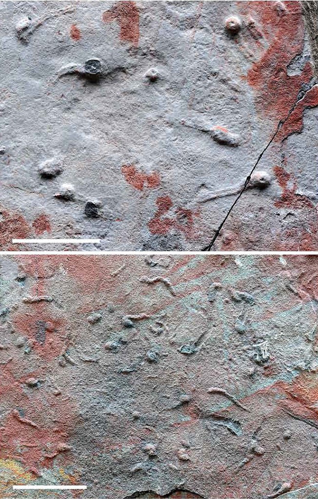
About 530 Ma ago most of the basic body plans of today’s living organisms can be detected as fossils, i.e. preserved hard parts. Yet studies of trace fossils (ichnofossils) – marks left in sediments by active soft bodied creatures suggest that many modern phyla arose before the start of the Cambrian (~539 Ma), as early as 545 Ma. So the term ‘Cambrian explosion’ seems to be a bit of a misnomer on two counts: it lasted around 15 Ma and began before the Cambrian. Preceding it was the Ediacaran Period that began around 100 Ma earlier in the Neoproterozoic Era. Traces of its eponymous fauna of large soft-bodied organisms are found on all continents, but apparently none of them made it into the Phanerozoic fossil record. Another characteristic of the Ediacaran is that its sedimentary rocks – and those of earlier times – show no signs of burrowing: they are not bioturbated. That may be why the Ediacaran pancake-, bun-, bag- and pen-like lifeforms are so remarkably well preserved. But a lack of burrowing did not extend to the beginning of Cambrian times. The most likely reason why it was absent during the early Ediacaran Period is that sea-floor sediments then were devoid of oxygen so eukaryote animals could not live in them. But the presence of these large organisms showed that seawater must have been oxygenated. Now clear signs of burrowing have emerged from study of Ediacaran rocks exposed in the Yangtze Gorge of Hubei,southern China ( Zhe Chen & Yarong Liu 2025. Advent of three-dimensional sediment exploration reveals Ediacaran-Cambrian ecosystem transition. Science Advances, v. 11, article eadx9449; DOI: 10.1126/sciadv.adx9449).
Tadpole-like trace fossils from the Ediacaran Dengying Formation in the Yangtze Gorge: 5 cm scale bars. The ‘heads’ show tiny depressions suggesting that there maker probed into the sediments as well as foraging horizontally. Credit: Zhe Chen & Yarong Liu; Figs 3B and 3D
Zhe Chen and Yarong Liu of the Nanjing Institute of Geology and Palaeontology and Chinese Academy of Sciences in China examined carbonates of the upper Ediacaran Dengying Formation. This overlies the Doushantuo Formation (550 to 635 Ma), known for tiny fossils of possibly the oldest deuterostome Saccorhytus coronaries; a potential candidate for the ancestor of modern bilaterian phyla. In the Yangtze Gorge locality sediments at this level show only traces of browsing of bacterial mats on the sediment surface; i.e. 2-D feeders. The basal Dengying sediments host clear signs that organisms could then penetrate into the sediments. These 3-D feeders , would have had access to buried organic remains, hitherto unexploited by living organisms. Such animal-sediment interactions would have disturbed and diminished the living microbial mats that held the sediment surface in place, and thus began to dismantle the substrate for the typical Edicaran fauna. Similar 3-D feeders occur throughout the 11 Ma represented by the Dengying Formation to the start of the Cambrian. This beginning of bioturbation heralded a period during which the Ediacaran fauna steadily waned. It also released nutrients into deep water, and opened up new ecological niches for more advanced animals on the seabed. Dissolved oxygen could only slowly enter the sediments since atmospheric and oceanic O2 levels were low. But by the earliest Cambrian it had risen to about 5 to 10% by volume to support many other kinds of burrowing animals that could penetrate more deeply, as witnessed by the abundant sandstones that occur at the base of the Cambrian in Britain.
Assigning human fossils older than around 250 ka to different groups of the genus Homo depends entirely on their physical features. That is because ancient DNA has yet to be found and analysed from specimens older than that. The phylogeny of older human remains is also generally restricted to the bones that make up their heads; 21 that are fixed together in the skull and face, plus the moveable lower jaw or mandible. Far more teeth than crania have been discovered and considerable weight is given to differences in human dentition. Teeth are not bones, but they are much more durable, having no fibrous structure and vary a great deal. The main problem for palaeoanthropologists is that living humans are very diverse in their cranial characteristics, and so it is reasonable to infer that all ancient human groups were characterised by such polymorphism, and may have overlapped in their physical appearance. A measure of this is that assigning fossils to anatomically modern humans, i.e. Homo sapiens, relies to a large extent on whether or not their lower mandible juts out to define a chin. All earlier hominins and indeed all other living apes might be regarded as ‘chinless wonders’! This pejorative term suggests dim-wittedness to most people, and anthropologists have had to inure themselves to such crude cultural conjecture.
The extraction, sequencing and comparison of ancient DNA from human fossils since 2010 has revealed that three distinct human species coexisted and interbred in Eurasia. Several well preserved examples of ancient Neanderthals and anatomically modern humans (AMH) have had their DNA sequenced, but a Denisovan genome has only emerged from a few bone fragments from the Denisova Cave in western Siberia. Whereas Neanderthals have well-known robust physical characters, until 2025 palaeoanthropologists had little idea of what Denisovans may have looked like. Then proteins and, most importantly, mitochondrial DNA (mtDNA) were extracted from a very robust skull found around 1931 in Harbin, China, dated at 146 ka. Analysis of the mtDNA and proteins, from dental plaque and bone respectively, reveal that the Harbin skull is likely to be that of a Denisovan. Previously it had been referred to as Homo longi, or ‘Dragon Man’, along with several other very robust Chinese skulls of a variety of ages.
The distorted Yunxian cranium (right) and its reconstruction (middle) [Credit: Guanghui Zhao] compared with the Harbin Denisovan cranium (left) [Hebei Geo University]
The sparse genetic data have been used to suggest the times when the three different coexisting groups diverged. DNA in Y chromosomes from Denisovans and Neanderthals suggest that the two lineages split from a common ancestor around 700 ka ago, whereas Neanderthals and modern humans diverged genetically at about 370 ka. Yet the presence of sections of DNA from both archaic groups in living humans and the discovery that a female Neanderthal from Denisova cave had a Neanderthal mother and a Denisovan father reveals that all three were interfertile when they met and interacted. Such admixture events clearly have implications for earlier humans. There are signs of at least 6 coexisting groups as far back as the Middle Pleistocene (781 to 126 ka), referred to by some as the ‘muddle in the middle’ because such an association has increasingly mystified palaeoanthropologists. A million-year-old, cranium found near Yunxian in Hubei Province, China, distorted by the pressure of sediments in which it was buried, has been digitally reconstructed.
This reconstruction encouraged a team of Chinese scientists, together with Chris Stringer of the UK Museum of Natural History, to undertake a complex statistical study of the Yunxian cranium. Their method compares it with anatomical data for all members of the genus Homo from Eurasia and Africa, i.e. as far back as the 2.4 Ma old H. habilis(Xiabo Feng and 12 others 2025. The phylogenetic position of the Yunxian cranium elucidates the origin of Homo longi and the Denisovans. Science, v. 389, p. 1320-1324; DOI: 10.1126/science.ado9202). The study has produced a plausible framework that suggests that the five large-brained humans known from 800 ka ago – Homo erectus (Asian), H. heidelbergensis, H. longi (Denisovans), H. sapiens, and H. neanderthalensis – began diverging from one another more than a million years ago. The authors regard the Yuxian specimen as an early participant in that evolutionary process. The fact that at least some remained interfertile long after the divergence began suggests that it was part of the earlier human evolutionary process. It is also possible that the repeated morphological divergence may stem from genetic drift. That process involves small populations with limited genetic diversity that are separated from other groups, perhaps by near-extinction in a population bottleneck or as a result of the founder effect when a small group splits from a larger population during migration. The global population of early humans was inevitably very low, and migrations would dilute and fragment each group’s gene pool.
The earliest evidence for migration of humans out of Africa emerged from the discovery of five 1.8 Ma old crania of H. erectus at Dmanisi to the east of the Black Sea in Georgia. similar archaic crania have been found in eastern Eurasia, especially China, at various localities with Early- to Middle Pleistocene dates. The earliest European large-brained humans – 1.2 to 0.8 Ma old H. antecessor from northern Spain – must have migrated a huge distance from either Africa or from eastern Eurasia and may have been a product of the divergence-convergence evolutionary framework suggested by Xiabo Feng and colleagues. Such a framework implies that even earlier members of what became the longi,heidelbergensis, neanderthalensis, and sapiens lineages may await either recognition or discovery elsewhere. But the whole issue raises questions about the widely held view that Homo sapiens first appeared 300 ka ago in North Africa and then populated the rest of that continent. Was that specimen a migrant from Eurasia or from elsewhere in Africa? The model suggested by Xiabo Feng and colleagues is already attracting controversy, but that is nothing new among palaeoanthropologists. Yet it is based on cutting edge phylogeny derived from physical characteristics of hominin fossils: the traditional approach by all palaeobiologists. Such disputes cannot be resolved without ancient DNA or protein assemblages. But neither is a completely hopeless task, for Siberian mammoth teeth have yielded DNA as old as 1.2 Ma and the record is held by genetic material recovered from sediments in Greenland that are up to 2.1 Ma old. The chances of pushing ancient human DNA studies back to the ‘muddle’ in the Middle Pleistocene depend on finding human fossils at high latitudes in sediments of past glacial maxima or very old permafrost, for DNA degrades more rapidly as environmental temperature rises.
For over a century Chinese scientists have been puzzling over ancient human skulls that show pronounced brow ridges. Some assigned them to Homo, others to species that they believe were unique to China. A widely held view in China was that people now living there evolved directly from them, adhering to the ‘Multiregional Evolution’ hypothesis as opposed to that of ‘Out of Africa’. However, the issue might now have been resolved. In the last few years palaeoanthropologists have begun to suspect that these fossilised crania may have been Denisovans, but none had been subject to genetic and proteomic analysis. The few from Siberia and Tibet that initially proved the existence of Denisovans were very small: just a finger bone and teeth. Out of the blue, teeth in a robust hominin mandible dredged from the Penghu Channel between Taiwan and China yielded protein sequences that matched proteomic data from Denisovan fossils in Denisova Cave and Baishiya Cave in Tibet, suggesting that Denisovans were big and roamed widely in East Asia. In 2021 a near-complete robust cranium came to light that had been found in the 1930s near Harbin in China and hidden – at the time the area was under Japanese military occupation. It emerged only when its finder revealed its location in 2018, shortly before his death. It was provisionally called Homo longi or ‘Dragon Man’. Qiaomei Fu of the Institute of Vertebrate Paleontology and Paleoanthropology in Beijing and her colleagues have made a comprehensive study of the fossil.
The cranium found near Harbin, China belonged to a Denisovan. Credit: Hebei Geo University
It is at least 146 ka old, probably too young to have been H.erectus, but predates the earliest anatomically modern humans to have reached East Asia from Africa (~60 ka ago). The Chinese scientists have developed protein- and DNA extraction techniques akin to those pioneered at the Max Planck Institute for Evolutionary Anthropology in Leipzig. It proved impossible to extract sufficient ancient nuclear DNA from the cranium bone for definitive genomic data to be extracted, but dental plaque (calculus) adhering around the only surviving molar in the upper jaw did yield mitochondrial DNA. The mtDNA matched that found in Siberian Denisovan remains (Qiaomei Fu et al. 2025. Denisovan mitochondrial DNA from dental calculus of the >146,000-year-old Harbin cranium. Cell, v. 188, p. 1–8; DOI: 10.1016/j.cell.2025.05.040). The bone did yield 92 proteins and 122 single amino acid polymorphisms, as well as more than 20 thousand peptides (Qiaomei Fu and 8 others 2025. The proteome of the late Middle Pleistocene Harbin individual. Science, v. 388: DOI: 10.1126/science.adu9677). Again, these established a molecular link with the already known Denisovans, specifically with one of the Denisova Cave specimens. Without the painstaking research of the Chinese team, Denisovans would have been merely a genome and a proteome without much sign of a body! From the massive skull it is clear that they were indeed big people with brains much the same size as those of living people. Estimates based on the Harbin cranium suggest an individual weighing around 100 kg (220 lb or ~15 stone): a real heavyweight or rugby prop!
The work of Qiaomei Fu and her colleagues, plus the earlier, more limited studies by Tsutaya et al., opens a new phase in palaeoanthropology. Denisovans now have a genome and well-preserved parts of an entire head, which may allow the plethora of ancient skulls from China to be anatomically assigned to the species. Moreover, by extracting DNA from dental plaque for the first time they have opened a new route to obtaining genomic material: dental calculus is very much tougher and less porous than bone.
During the Middle Palaeolithic (250 to 30 ka) anatomically modern humans (AMH) and Neanderthals were engaged in new technological developments in Europe and Africa as well as in migration and social interaction. This is reflected in the tools that they left at occupation sites and the fact that most living non-Africans carry Neanderthal DNA. One of the major cultural developments was a novel means of manufacturing stone implements. It developed from the Levallois technique that involved knapping sharp-edged flakes of hard rock from larger blocks or cores. A type of tool first found at a Neanderthal site near La Quina in France is a thick flake of stone with a broad, sharp edge that shows evidence of having been resharpened many times. Most other flake tools seem to have been ‘one-offs’ that were discarded after brief usage. The Quina version was not only durable but seems to have been multipurpose. Analysis of wear patterns on the sharpened edges suggest that they were deployed in carving wood and bone, removing fat and hair from animal hides, and butchery. Such scrapers have been found over a wide area of Europe, the Middle East and NE Asia mostly at Neanderthal sites, including the famous Denisova Cave of southern Siberia that yielded the first Denisovan DNA as well as that of Neanderthals.
Making a typical Quina scraper and related tools. The toolmaker would flake pieces of stone off the core and then carefully shape the Quina scraper. (Image credit: Pei-Yuan Xiao)
Until now, the early humans of East Asia were thought not to have proceeded beyond more rudimentary tools during the Middle Palaeolithic: in fact that archaeological designation hasn’t been applied there. Recent excavations at Longtan Cave in south-west China have forced a complete revision of that view (Ruan, Q.-J., et al. 2025. Quina lithic technology indicates diverse Late Pleistocene human dynamics in East Asia. Proceedings of the National Academy of Sciences, v. 122, article e2418029122; DOI: 10.1073/pnas.2418029122). The Longtan site has yielded more than fifty scrapers and the cores from which they had been struck that clearly suggest the Quina technology had been used there. They occur in cave sediments dated at between 60 and 50 ka. As yet, no human remains have been found in the same level at Longtan, although deeper levels dated at 412 ka have yielded hominin crania, mandibular fragments, and teeth, that have been suggested to be Homo erectus.
Quina type tools in East Asia may previously have been overlooked at other hominin sites in China: re-examination of archived tool collections may show they are in fact widespread. The technology could have been brought in by migrating Neanderthals, or maybe it was invented independently by local East Asian hominins. Because most living people in China carry Denisovan DNA in the genomes so perhaps that group developed the technique before interbreeding with AMH immigrants from the west. Indeed there is no reason to discard the notion that early AMH may have imported the Quina style. A lot of work lies ahead to understand this currently unique culture at Longtan Cave. However, interpretation of another discovery published shortly after that from Longtan has spectacularly ‘stolen the thunder’ of the Qina tools, and it was made in Taiwan …
Right (top) and downward (lower) views of the partial Penghu mandible. Credit: Yousuke Kaifu University of Tokyo, Japan and Chun-Hsiang Chang Tunghai University, Taichung, from Tsutaya et al. Fig. 1 (inset)Taiwan.
About 10 years ago, Taiwanese fishers trawling in the Penghu Channel between Taiwan and China were regularly finding bones in their nets. Between 70 to 10 ka and 190 to 130 ka ago much lower sea level due to continental ice cap formation exposed the Penghu seabed. Animals and humans were thus able to move between the East Asian mainland and what is now Taiwan. The bones brought to the surface included those of elephants, water buffaloes and tigers, but one was clearly a human lower jawbone (mandible). Its shape and large molar teeth are very different from modern human mandibles and molars. A multinational team from Japan, Denmark, Taiwan and Ireland has extracted proteins from the mandible to check its genetic affinities (Tsutaya, T. and 14 others 2025. A male Denisovan mandible from Pleistocene Taiwan. Science, v. 388, p. 176-180; DOI: 10.1126/science.ads3888). Where DNA has not been preserved in bones proteomics is a useful tool, especially if results are matched with other bones that have yielded both DNA and protein sequences. In the case of the Penghu mandible, proteins from its teeth matched those of Denisovans from the Denisova Cave in Siberia which famously yielded the genome of this elusive human group. They also matched proteins from a rib found in Tibet associated with Denisovan mitochondrial DNA in cave sediments that enclosed the bones.
The three sites (Denisova, Baishiya Cave in Tibet and Penghu Channel) that have produced plausible Denisovan specimens span a large range of latitudes and altitudes. This suggests that Denisovans were capable of successful subsistence across much of East Asia. The Penghu mandible and teeth are similar to several hominin specimens from elsewhere in China that hitherto have been attributed to H. erectus. Apart from the Denisovan type locality, most of the sites have yet to be accurately dated. Having been immersed in sea water for thousands of years isotopes used in dating have been contaminated in the Panghu specimen. It can only be guessed to have lived when the seabed from which it was recovered was dry land; i.e. between 70 to 10 ka and 190 to 130 ka. China was undoubtedly occupied by Homo erectus during the early Pleistocene, but much younger fossils have been attributed to that species by Chinese palaeoanthropologists. Could it be that they are in fact Denisovans? Maybe such people independently developed the Quina knapping technique
See also: Marwick, B. 2025. Unknown human species in East Asia used sophisticated tools at the same time Neanderthals did in Europe. Live Science, 31 March 2025; Ashworth. J. 2025. Denisovan jawbone helps to reveal appearance of ancient human species. Natural History Museum News 11 April 2025.
A fully revised edition of Steve Drury’s book Stepping Stones: The Making of Our Home World can now be downloaded as a free eBook
Chinese apothecary shops sell an assortment of fossils. They include shells of brachiopods that when ground up and dissolved in water allegedly treat rheumatism, skin diseases, and eye disorders. Traditional apothecaries also supply ‘dragons’ teeth’, said by Dr Subhuti Dharmananda, Director of the Institute for Traditional Medicine in Portland, Oregon to treat epilepsy, madness, manic running about, binding qi (‘vital spirit’) below the heart, inability to catch one’s breath, and various kinds of spasms, as well as making the body light, enabling one to communicate with the spirit light, and lengthening one’s life. Presumably have done a roaring trade in ‘dragons’ teeth’ since they were first mentioned in a Chinese pharmacopoeia (the Shennong Bencao Jing) from the First Century of the Common Era. In 1935 the anthropologist Gustav von Koenigswald came across two ‘dragons’ teeth’ in a Hong Kong shop. They were unusually large molars and he realised they were from a primate, but far bigger (20 × 22 mm) than any from living or fossil monkeys, apes or humans.
Eventually, in 1952 (he had been interned by Japanese forces occupying Java), von Koenigswald formally described the teeth and others that he had found. Their affinities and size prompted him to call the former bearer the ‘Huge Ape’ (Gigantopithecus). By 1956 Chinese palaeontologists had tracked down the cave site in Guangxi province where the teeth had been sourced, and a local farmer soon unearthed a complete lower jawbone (mandible) that was indeed gigantic. More teeth and mandibles have since been found at several sites in Southern and Southeast Asia, with an age range from about 2.0 to 0.3 Ma. Anatomical differences between teeth and mandibles suggest that there may have been 4 different species. Using mandibles as a very rough guide to overall size it has been estimated that Gigantopithecus may have been up to 3 m tall weighing almost 600kg.
Above: Size comparison of G. blacki with a 1.8 m tall human male; NB G.blacki probably walked on all fours, as do living orangutans when they rarely descend from the forest canopy. (Credit: Frido Welker) Below: Mandible of Gigantopithecus blacki from India (Credit: Prof. Wei Wang, Photo retouched by Theis Jensen)
Plaque on some teeth contain evidence for fruit, tubers and roots, but not grasses, which suggest suggest that Gigantopithecus had a vegetarian diet based on forest plants. Mandibles also showed affinities with living and fossil orangutans (pongines). Analysis of proteins preserved in tooth enamel confirm this relationship (Welker, F. and 17 others 2019. Enamel proteome shows that Gigantopithecus was an early diverging pongine. Nature, v.576, p. 262–265; DOI: 10.1038/s41586-019-1728-8). It was one of the few members of the southeast Asian megafauna to go extinct at the genus level during the Pleistocene. Its close relative Pongo the orangutan survives as three species in Borneo and Sumatra. Detailed analysis of material from 22 southern Chinese caves that have yielded Gigantopithecus teeth has helped resolve that enigma (Zhang, Y. and 20 others 2024. The demise of the giant ape Gigantopithecus blacki. Nature, v. 625; DOI: 10.1038/s41586-023-06900-0).
At the time Gigantopithecus first appeared in the geological record of China (~2.2 Ma), it ranged over much of south-western China. The early Pleistocene ecosystem there was one of diverse forests sufficiently productive to support large numbers of this enormous primate and also the much smaller orangutan Pongo weidenreichi. By 295 to 215 ka, the age of the last known Gigantopithecus fossils, its range had shrunk dramatically. The teeth show marked increases in size and complexity by this time, which suggests adaptation of diet to a changing ecosystem. That is confirmed by pollen analysis of cave sediments which reveal a dramatic decrease in forest cover and increases in fern and non-arboreal flora at the time of extinction. One physical sign of environmental stress suffered by individual late G. blacki is banding in their teeth defined by large fluctuations of barium and strontium concentrations relative to calcium. The bands suggest that each individual had to change its diet repeatedly over its lifetime. Closely related orangutans, on the other hand survived into the later Pleistocene of China, having adapted to the changed ecosystem, as did early humans in the area. It thus seems likely that Gigantopithecus was an extreme specialist as regards diet, and was unable to adapt to changes brought on by the climate becoming more seasonal. Today’s orangutans in Indonesia face a similar plight, but that is because they have become restricted to forest ‘islands’ in the midst of vast areas of oil palm plantations. Their original range seems to have been much the same as that of Gigantopithecus, i.e. across south-eastern Asia, but Pongo seems to have gone extinct outside of Indonesia (by 57 ka in China) during the last global cooling and when forest cover became drastically restricted.
Geologists of my generation leaned that the earliest signs of abundant and diverse animal life were displayed by an extraordinary assemblage of fossils in a mudstone exposure high on a ridge in the Rocky Mountains of British Columbia. The Burgess Shale lagerstätte, or ‘site of exceptional preservation’, was discovered by Charles Walcott in 1909. It contained exquisite remains, some showing signs of soft tissue, of a great range of animals, many having never before been seen. Though dated at 509 Ma (Middle Cambrian) it was regarded for much of the 20th century as the sign of a sudden burgeoning from which all subsequent life had evolved: the Cambrian Explosion. Walcott only scratched the surface of its riches, its true wonders only being excavated and analysed later by Harry Whittington and his protégé Simon Conway Morris of Cambridge University. Their results were summarised and promoted in one of the great books on palaeontology and evolutionary biology, Wonderful Life (1989) by Steven Jay Gould.
Harbingers of animal profusion first appear around 635 Ma in the Late Neoproterozoic as the Ediacaran Fauna, with the oldest precursors turning up around a billion years ago in the Torridonian Sandstone Formation of northern Scotland. The evolutionary links between them and the Cambrian Explosion are yet to be documented, as creatures of the Ediacaran remain elusive in the earliest Phanerozoic rocks. As regards the conditions that promoted the explosion of animal faunas, the Burgess Shale is a blank canvas, for its riches were not preserved in situ, but had drifted onto deep, stagnant ocean floor to be preserved in oxygen-poor muds that enabled their intricate preservation. The animals could not have lived and evolved without abundant oxygen: what that environment was is not recorded by Walcott’s famous stratigraphic site.
Artistic impression of the Chengjian Biota
China, it has emerged, offers a major clue from around 40 lagerstätten in Chengjian County, Yunnan. They are not only older (518 Ma) than the Burgess Shale but contain 27 percent more faunal diversity: 17 phylums and more than 250 species. Since the discovery of the Chengjian Biota in the first decade of the 21st century palaeontologists have, understandably, been preoccupied by describing its riches in hundreds of scientific papers. The nature of the ecosystem has remained as obscure as that of the Burgess Shale, largely due to the exposed host rocks (laminated siltstones and mudstones) having been weathered. They are superficially similar to the Burgess Shale. In March 2022, 10 scientists working at laboratories in China, Canada, Switzerland and the UK published the results of their painstaking sedimentological investigation of a core dilled through through the entire fossiliferous sequence (Salih, F. and 9 others 2022. The Chengjiang Biota inhabited a deltaic environment. Nature Communications, v. 13, article 1569; DOI: 10.1038/s41467-022-29246-z).
Reconstruction of the near-shore deltaic environment in which the Chengjian Biota lived and evolved. Several rock types and the
sedimentary processes that probably formed them shown in ‘cores’ (Credit: Salih et al. Figure 3)
The unweathered core displays a variety of tiny sedimentary structures. These include cross laminations formed by migrating ripples, occasional fine sandstones that include signs of burrowing, graded bedding formed by minor turbidity currents, hummocks formed by back and forth water flow, ripples formed by flow in a single direction and small channels. Unlike the Burgess Shale, the fine-grained Chengjian sediments seem to have been deposited in environments that were far from stagnant and deep. They most closely resemble the offshore parts of the delta of a predominantly muddy river, subject to occasional floods and storms and characterised by large and rapid accumulation of mud and silt by dense sediment-loaded river water flowing down a gently sloping seabed into clearer seawater. That the sediment supply was full of nutrients and oxygen is reflected by small organisms living in burrows. The high-quality preservation of fossils in some layers can be attributed to sudden influxes of freshwater into their marine habitat during storms, so that they were killed in place. Such a near-shore environment, full of nutrients and oxygen but subjected to repeated geochemical and physical stresses, can explain adaptive radiation and evolution at a fast pace. Clearly, that is by no means a full explanation of the Cambrian Explosion, but offers sufficient insight for research to proceed fruitfully.
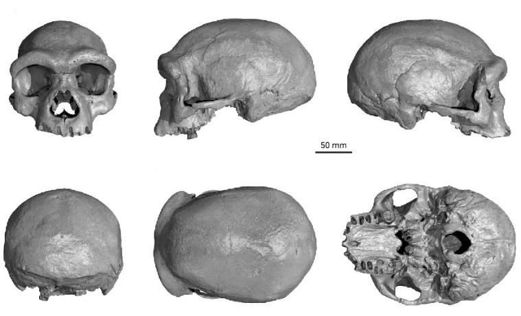
In 1933 labourers unearthed a very large skull during the construction of a bridge near Harbin, Northern China. At that time, the area was under occupation by Imperial Japanese forces. To keep it out of the invaders’ hands the skull was quickly wrapped in a cloth and hidden in an old well. It was only in 2018 that the original finder’s grandson recovered it to pass on to archaeologists at Hebei Geo University. It lacks a lower jawbone, so technically it is a cranium, but is very well preserved. The face has very large brow ridges – generally taken as a primitive feature – but also some more modern features. With a 1,420 ml brain case, it is significantly larger than most modern human crania. Apparently, it is of an adult male. As well as a big head, he had a large nose, as do Neanderthals: a possible adaptation to very cold conditions. Without waiting to see if the bones might yield DNA, five of the team who examined the cranium claimed it as a new species, Homo longi or ‘Dragon Man’; i.e. distinct from modern humans and Neanderthals and all known older hominins (Ni, X. et al. 2021. Massive cranium from Harbin establishes a new Middle Pleistocene human lineage in China. The Innovation, v. 2, article 100130; DOI: 10.1016/j.xinn.2021.100130. Ji, Q. et al. 2021. Late Middle Pleistocene Harbin cranium represents a new Homo species. The Innovation, v. 2, article 100132; DOI: 10.1016/j.xinn.2021.100132). They based this phylogenetic interpretation on morphology alone. At least one of the team, Chris Stringer a leading hominin palaeoanthropologist at The Natural History Museum in London, demurred. The cranium is not unique and bears close similarity to another from the central Chinese province of Shaanxi, which was found in the late 1970s. In fact there are three other Chinese crania that resemble that from Harbin, although they are less well preserved.
All-sided views of the Harbin cranium. (Credit: Ni et al., Fig 2)
Dating the fossil was not easy, as the site where labourers discovered him was destroyed during construction of the bridge. Researchers used a variety of geochemical analyses, including from sediment stuck in his nasal cavity, to derive a likely stratigraphic profile from which the cranium may have been excavated. The best fit is with Middle Pleistocene sediments in the Harbin area. Uranium-series dating of the bone suggests that it is older than 146 ka (Shao, Q. et al. 2021. Geochemical locating and direct dating of the Harbin archaic human cranium. The Innovation, v. 2, article 100131; DOI: 10.1016/j.xinn.2021.100131). So it is likely that this man and his companions did not cohabit China with anatomically modern humans, who arrived no more than about 50 ka ago. The highly robust nature of all the similar crania suggests that the individuals must have been large and physically active. Like the Neanderthals, they had adapted to harsh conditions over several hundred thousand years of repeated climate change. Even today, winters in northern China average around -16°C, and far inland conditions are semi-arid to arid. For them to migrate would have involved traversing some of highest, bleakest passes in the world. These people evolved to survive extreme climatic and environmental change, much as did the Neanderthals in West Asia and Europe. By comparison anatomically modern humans evolved in the more stable environments of Africa and the Middle East, surviving only the last ice age once they had migrated northwards. Those who made it to northern Siberia and crossed the Bering Strait via Beringia around the last glacial maximum did evolve physical traits that helped them survive, but minor ones compared with the earlier humans.
So what do these Chinese fossils represent? Using cranial features alone to propose distinct species smacks of the techniques of 19th and early 20th century anatomical anthropologists, albeit with powerful statistical analysis. We know that anatomically modern humans carry genetic signatures of interbreeding with at least two known ‘species’ with whom they cohabited Eurasia – Neanderthals and Denisovans. Indeed, traces in the DNA of living African and Eurasian humans hint at other unknown and probably very ancient ‘ghost’ populations. Genetic, physical and probably cultural differences did not deter repeated interbreeding with these ‘others’. To be frank, erecting new human ‘species’ these days seems to serve little purpose. ‘Dragon Man’ is just as likely to represent the Denisovans as the fully sequenced DNA from a couple of bones from caves in Siberia and Tibet. The latter matched stretches of the DNA from living people of East Asia and parts of the Pacific. There are no other such live genetic tracers awaiting a different candidate to fill the role that we know Neanderthals and Denisovans to have filled. That may yet change, but the first job for the mainly Chinese consortium of scientists is to get genetic material from these crania and sequence it, or invite other highly successful palaeogeneticists who would leap at the opportunity.
It is easy to think that firm evidence for past glaciations lies in sedimentary strata that contain an unusually wide range of grain size, a jumble of different rock types – including some from far-off outcrops – and a dominance of angular fragments: similar to the boulder clay or till on which modern glaciers sit. In fact such evidence, in the absence of other signs, could have formed by a variety of other means. To main a semblance of hesitancy, rocks of that kind are now generally referred to as diamictites in the absence of other evidence that ice masses were involved in their deposition. Among the best is the discovery that diamictites rest on a surface that has been scored by the passage of rock-armoured ice – a striated pavement and, best of all, that the diamictites contain fragments that bear flat surfaces that are also scratched. The Carboniferous to Permian glaciation of the southern continents and India that helped Alfred Wegener to reconstruct the Pangaea supercontinent was proved by the abundant presence of striated pavements. Indeed, it was the striations themselves that helped clinch his revolutionising concept. On the reconstruction they formed a clear radiating pattern away from what was later to be shown by palaeomagnetic data to be the South Pole of those times.
29 Ma old striated pavement beneath the Dwyka Tillite in South Africa (credit: M.J Hambrey)
The multiple glacial epochs of the Precambrian that extended to the Equator during Snowball Earth conditions were identified from diamictites that are globally, roughly coeval, along with other evidence for frigid climates. Some of them contain dropstones that puncture the bedding as a result of having fallen through water, which reinforces a glacial origin. However, Archaean and Neoproterozoic striated pavements are almost vanishingly rare. Most of those that have been found are on a scale of only a few square metres. Diamictites have been reported from the latest Neoproterozoic Ediacaran Period, but are thin and not found in all sequences of that age. They are thought to indicate sudden climate changes linked to the hesitant rise of animal life in the run-up to the Cambrian Explosion. One occurrence, for which palaeomagnetic date suggest tropical latitude, is near Pingdingshan in central China above a local unconformity that is exposed on a series of small plateaus (Le Heron, D.P. and 9 others 2019. Bird’s-eye view of an Ediacaran subglacial landscape. Geology, v. 47, p. 705-709; DOI: 10.1130/G46285.1). To get a synoptic view the authors deployed a camera-carrying drone. The images show an irregular surface rather than one that is flat. It is littered with striations and other sub-glacial structures, such as faceting and fluting, together with other features that indicate plastic deformation of the underling sandstone. The structures suggest basal ice abrasion in the presence of subglacial melt water, beneath a southward flowing ice sheet
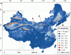
Two weeks after Earth pages featured arsenic in groundwater below the Mekong Delta another important paper has emerged about modelling risk of arsenic contamination throughout the People’s Republic of China (Rodriguez-Lado, L. et al. 2013. Groundwater arsenic contamination throughout China. Science, v. 341, p. 866-868). Scientists based in the Swiss Federal Institute of Aquatic Science and technology and the China Medical University follow up the results of geochemical testing of groundwater from almost 450 thousand wells in 12% of China’s counties; part of a nationwide aim to test millions of wells. That is a programme likely to last for decades, and their work seeks to develop a predictive model that might better focus such an enormous effort and help in other large regions where well sampling is not so advanced.
As well as the well-known release of arsenic-containing ions through the dissolution of iron oxy-hydroxides in aquifers that exhibit reducing conditions, aridity that causes surface evaporation can create alkaline conditions in groundwater that also desorbs arsenic from similar minerals. The early results from China suggested 16 environmental factors available in digital map form, mainly geological, topographic and hydrogeochemical, that possibly encourage contamination; a clear indication of the sheer complexity of the problem. Using GIS techniques these possible proxies were narrowed down to 8 that show significant correlation with arsenic levels above the WHO suggested maximum tolerable concentration of 10 micrograms per litre (10 parts per billion by volume). Geology (Holocene sediments are most likely sources), the texture of soils and their salinity, the potential wetness of soils predicted from topography and the density of surface streams carrying arsenic correlate positively with high well-water contamination, whereas slope, distance from streams and gravity (a measure of depth of sedimentary basins) show a negative correlation. These parameters form the basis for the predictive model and more than 2500 new arsenic measurements were used to validate the results of the analysis.
Estimated probability of arsenic in Chinese groundwater above the WHO acceptable maximum concentration (Credit:Rodriguez-Lado, et al. 2013)
The results graphically highlight possible high risk areas, mainly in the northern Chinese provinces that are partly confirmed by the validation. Using estimated variations in population density across the country the team discovered that as many as 19.6 million people may be affected by consumption of arsenic contaminated water. In fact if groundwater is used for irrigation, arsenic may also be ingested with locally grown food. It seems that the vast majority of Chinese people live outside the areas of risk, so that mitigating risk is likely to be more manageable that it is in Bangladesh and West Bengal.
As well as being an important input to environmental health management in the PRC the approach is appropriate for other large areas where direct water monitoring is less organised, such as Mongolia, Kazakhstan and Kyrgyzstan in central Asia, and in the arid regions of South America.
In late 2010 it emerged from genomic studies of a finger bone from Denisova Cave in eastern Siberia that a probably archaic human group had shared genes with ancestors of some modern humans who colonised West Pacific islands around 45 Ka ago, well before the last glacial maximum. Melanesians, including tpeople living in Papua-New Guinea have DNA that contains on average around 6% contributed from fertile interbreeding with Denisovans. This ancient groups are suggested by comparative studies of their and Neanderthal mitochondrial DNA to have split from them as lond as a million years ago. Now it seems possible that much more complete fossils of Denisovans may have been discovered in China (Curnoe, D. And 16 others 2012. Human Remains from the Pleistocene-Holocene Transition of Southwest China Suggest a Complex Evolutionary History for East Asians. PLoS ONE, http://www.plosone.org/article/info:doi/10.1371/journal.pone.0031918).
Skull from Red Deer Cave in Guanxi Province, southern China. Darren Curnoe
A block of sediment from Longlin Cave in Guanxi Province in southern China that was collected more than 30 years ago, has yielded skull fragments whose reconstruction reveals a most unusual individual, very different from anatomically modern humans, Neanderthals and from H. erectus. It had a wide flat face with highly prominent cheek bones, strong brow ridges and a diminutive chin. Remains of three other individuals found by recent excavations in Maludong (Red Deer) Cave 300 km to the south of Longlin share similar characteristics. Yet there are similarities to moderns, for instance CT-scans show that the brain likely had a height and frontal lobes similar to ours, but different from Neanderthals.
These are not truly ancient fossils; radiocarbon and uranium-series dating give an age range from 14.3 to 11.5 ka, around the time of the Younger Dryas cold episode that preceded the Holocene. These two individuals lived when East Asia had long been home to fully modern humans.
The finds perhaps open a major new focus for human evolution, directed towards less-well studied older fossils from elsewhere in the East including those referred to by Jonathan Kingdon as ‘Mapas’ from both southern and northern China. Certainly it will boost palaeoanthropological research within China
China's growing REE market share. Image via Wikipedia
Since the now far-off founding of the Club of Rome and the re-emergence of Malthusian ideology, time and again there have been warnings about the imminent running out of resources that are essential for modern life. The latest concern one of the formerly haunted wings of the Periodic Table, central to petrogenetic geochemistry, but little else; the rare-earth elements. From early beginnings as the source for phosphors in the screens of colour televisions all 15 REEs now have a growing commercial role in applications ranging from precision guided weapons, night-vision goggles and stealth technology in the military sphere, through the satiation of artificial appetites for electronic gaming and mobile phones, to applications of super-efficient magnets in medial scanners and ‘green’ power generation. The crisis being discussed currently is not so much a shortage – REEs are not so rare – but the cornering of their mining by the Peoples’ Republic of China, which produces more than 95% of RREs used at present (~120 thousand tons). Yet world reserves are estimated at almost 100 million t, of which China has 36 million. Mining is often in only a few known, high-grade deposits; for instance most of the US reserves of 13 million t are locked in the Mountain Pass Mine, California that is currently on a ‘care-and-maintenance’ regime, i.e. shut. This one-sided economy sends shudders through capital’s strategy forums, i.e. in the US, Silicon Valley and the Pentagon.
Not surprisingly, geochemists and oceanographers from Japan, the world’s most hi-tech country, have bent their collective will to finding alternative sources, and may have revealed one in an unexpected location (Kato, Y. et al. 2011. Deep-sea mud in the Pacific Ocean as a potential resource for rare-earth elements. Nature Geoscience, v. 4, p. 535-539). Their work stems from ‘mining’ existing geochemical data from deep-sea drilling projects on the floor of the Pacific Ocean, that reveal a wide range of REE concentrations in the ooze coating the seabed: from <250 to >2000 parts per million. The richest pickings seem to lie in a swath either side of the East Pacific Rise at around 15°S, where the group estimate that a 1 km2 plot could yield about one fifth of current world annual production, even though REE concentrations lie way below their on-shore economic cut-off grade. Apart from the need for dredging at depths around 3-5 km on the abyssal plains, and the inevitability of destroying a largely unknown ecosystem, the positive aspect of these metal-rich oozes is that the REE can be extracted simply by acid leaching of the goethite (FeOOH) in which the bulk of the elements reside. Goethite is something of a geochemical ‘mop’ with a capacity for adsorbing elements of all kinds on grain surfaces; so much so that it is being considered as a means of cleaning up heavy-metal pollution. Both the REEs and the iron probably arise from seabed hot springs where oxidising conditions result in dissolved ferrous iron combining in ferric form with oxygen to form goethite, which in turn scavenges other dissolved ions. Many of the on-shore REE deposits are carbonatites (intrusions of carbonate-rich magmas) that contain fluoro-carbonates and phosphates that host the REE, or beach sands in which wave swash concentrates the durable heavy phosphates in so-called black-sand deposits. Carbonatites are rare, most occurring in ancient ‘shields’, as in southern Africa, Canada and China, but being so unusual are not difficult to find. One in the Canadian Shield known as the Big Spruce Lake deposit provides phosphorus- and potassium-rich soil that encourages the growth f conifers and so creates a geobotanical anomaly of large trees where local climate generally supports only stunted ones.
The rising demand and currently restricted supply of REEs is creating an exploration boom for carbonatites as the metal prices rise inexorably. Yet it may also produce a shift to what seems to be an alternative kind of source; iron-rich deep-sea sediments, though more likely those preserved on-shore in ophiolite complexes than at the huge depths of the abyssal plains. It is worth bearing in mind, however, that oceanographers and geochemists have pointed to untold metal riches before: manganese nodules that litter huge tracts of the seabed and contain sufficient copper, nickel and cobalt to maintain supplies for millennia. Despite a half-billion dollar investment in the 1960s and 70s, there is no nodule-dredging industry. There are however well-advanced plans for deep water mining of gold-rich hydrothermal sites, but miners will go just about anywhere to gloat over Marx’s ‘money commodity’