Followers can now download newly posted annual logs for Human Evolution and Migrations covering the years 2022 to 2025. By downloading them you can get a clear idea of how palaeoanthropology has moved forward since the Covid pandemic.
Enjoy the experience if you have the time and inclination!
Curiously, two weeks after my previous post about Stonehenge, a wider geochemical study of the Devonian sandstones and a number of Neolithic megaliths in Orkney seems to have ruled out the Stonehenge Altar Stone having been transported from there (Bevins, R.E. et al. 2024. Was the Stonehenge Altar Stone from Orkney? Investigating the mineralogy and geochemistry of Orcadian Old Red sandstones and Neolithic circle monuments. Journal of Archaeological Science: Reports, v. 58, article 104738; DOI: 10.1016/j.jasrep.2024.104738). Since two of the authors of Clarke et al. (2024) were involved in the newly published study, it is puzzling at first sight why no mention was made in that paper of the newer results. The fact that the topic is, arguably, the most famous prehistoric site in the world may have generated a visceral need for getting an academic scoop, only for it to be dampened a fortnight later. In other words, was there too much of a rush?
The manuscript for Clarke et al. (2024) was received by Nature in December 2023 and accepted for publication on 3 June 2024; a six-month turnaround and plenty of time for peer review. On the other hand, Bevins et al. (2024) was received by the Journal of Archaeological Science on 23 July 2024, accepted a month later and then hit the website a week after that: near light speed in academic publishing. And it does not refer to the earlier paper at all, despite two of its authors’ having contributed to it. Clarke et al. (2024) was ‘in press’ before Bevins et al. (2024) had even hit the editor’s desk. The work that culminated in both papers was done in the UK, Australia, Canada and Sweden, with some potential for poor communication within the two teams. Whatever, the first paper dangled the carrot that Orkney might have been the Altar Stone’s source, on the basis of geochemical evidence that the grains that make up the sandstone could not have been derived from Wales but were from the crystalline basement of NE Scotland. The second shows that this ‘most popular’ Scottish source may be ruled out. To Orcadians and the archaeologists who worked there, long in the shade of vast outpourings from Salisbury Plain, this might come as a great disappointment.
Cyclical sediments of the Devonian Stromness Flagstones. (Credit Mike Norton, Wikimedia)
The latest paper examines 13 samples from 8 outcrops of the Middle Devonian Stromness Flagstones strata in the south of the main island of Orkney close to the Ring of Brodgar and the Stones of Stenness, and the individual monoliths in each. On the main island, however, there is a 500 m sequence of Stromness Flagstones in which can be seen 50 cycles of sedimentation. Each cycle contains sandstone beds of various thicknesses and textures. They are fluviatile, lacustrine or aeolian in origin. So the Neolithic builders of Orkney had a wide choice, depending on where they erected monumental structures. Almost certainly they chose monolithic stones where they were most easy to find: close to the coast where exposure can be 100 %. The Ring of Brodgar and the Stones of Stenness are not on the coast, so the enormous stones would have to be dragged there. There is an ancient pile of stones (Vestra Fiold) about 20 km to the NW where some of the mmegaliths may have been extracted, but ancient Orcadians would have been spoilt for choice if they had their hearts set on erecting monoliths!
In a nutshell, the geological case made by Bevins et al. (2024) for rejecting Orkney as the source for the Stonehenge Altar Stone (AS) is as follows: 1. Grains of the mineral baryte (BaSO4) present in the AS are only found in two of the Orkney rock samples. 2. All the Orcadian sandstone samples contain lots of grains of K-feldspar (KAlSi3O8) – common in the basement rocks of northern Scotland – but the AS contains very little. 3. A particular clay mineral (tosudite) is plentiful in the AS, but was not detected in the rock samples from Orkney. Does that rule out a source in Orkney altogether? Well, no: only the outcrops and megalith samples involved in the study are rejected.
To definitely negate an Orcadian source would require a monumental geochemical and mineralogical study across Orkney; covering every sedimentary cycle. Searching the rest of the Old Red Sandstone elsewhere in NE Scotland – and there is a lot of it – would be even more likely to be fruitless. Tracking down the source for the basaltic bluestones at Stonehenge was easy by comparison, because they crystallised from a particular magma over a narrow time span and underwent a specific degree of later metamorphism. They were easily matched visually and under the microscope with outcrops in West Wales in the 1920s and later by geochemical features common to both.
But all that does not detract from the greater importance of the earlier paper (Clarke et al., 2024), which enhanced the idea of Neolithic cultural coherence and cooperation across the whole of Britain. The building of Stonehenge drew people from the far north of Scotland together with those of what are now Wales and England. Since then it hasn’t always been such an amicable relationship …
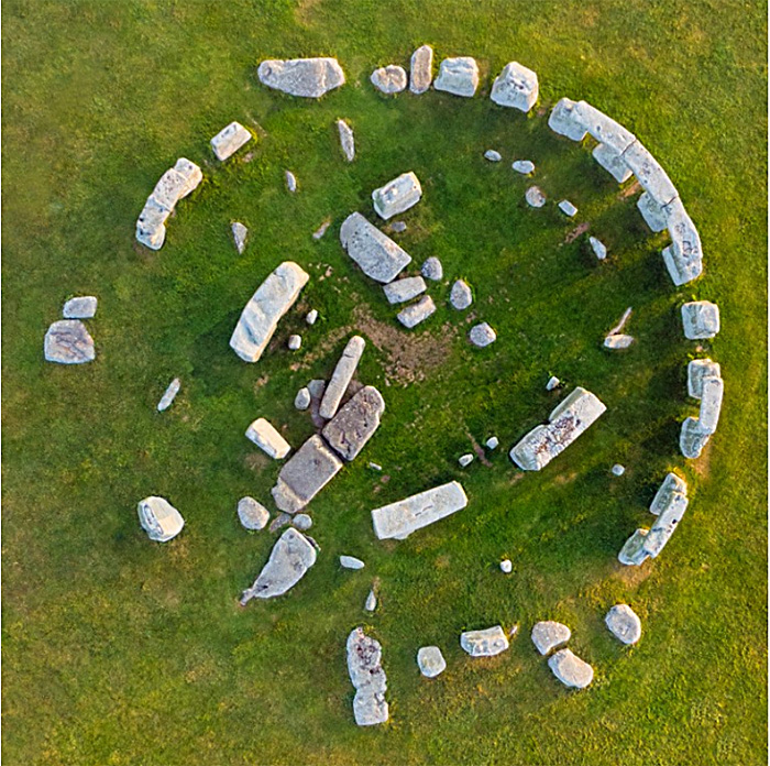
High resolution vertical aerial photograph of Stonehenge. (Credit: Gavin Hellier/robertharding/Getty)
During the later parts of the Neolithic the archipelago now known as the British Isles and Ireland was a landscape on which large stone buildings with ritual and astronomical uses were richly scattered. The early British agricultural societies also built innumerable monuments beneath which people of the time were buried, presumably so that they remained in popular memory as revered ancestors. Best known among these constructions is the circular Stonehenge complex of dressed megaliths set in the riot of earlier, contemporary and later human-crafted features of the Chalk downs known as Salisbury Plain. Stonehenge itself is now known to have been first constructed some five thousand years ago (~3000 BCE) as an enclosure surrounded by a circular ditch and bank, together with what seems to have been a circular wooden palisade. This was repeatedly modified during the following two millennia. Around 2600 BCE the wooden circle was replaced by one of stone pillars, each weighing about 2 t. These ‘bluestones’ are of mainly basaltic igneous origin unknown in the Stonehenge area itself. The iconic circle of huge, 4 m monoliths linked by 3 m lintel stones that enclose five even larger trilithons arranged in a horseshoe dates to the following two-centuries to 2400 BCE coinciding with the Early Bronze Age when newcomers from mainland Europe – perhaps as far away as the steppe of western Russia – began to replace or assimilate the local farming communities. This phase included several major modifications of the earlier bluestones.
It might seem that the penchant for circular monuments began with the Neolithic people of Salisbury Plain, and then spread far and wide across the archipelago in a variety of sizes. However, it seems that building of sophisticated monuments, including stone circles, began some two centuries earlier than in southern England in the Orkney Islands 750 km further north and, even more remote, in the Outer Hebrides of Scotland. A variety of archaeological and geochemical evidence, such as the isotopic composition of the bones of livestock brought to the vicinity of Stonehenge during its period of development and use, strongly suggests that people from far afield participated. Remarkably, a macehead made of gneiss from the Outer Hebrides turned up in an early Stonehenge cremation burial. Ideas can only have spread during the Neolithic through the spoken word. As it happens, the very stones themselves came from far afield. The earliest set into the circular structure, the much tinkered-with bluestones, were recognised to be exotic over a century ago. They match late Precambrian dolerites exposed in western Wales, first confirmed in the 1980s through detailed geochemical analyses by the late Richard Thorpe and his wife Olwen Williams-Thorpe of the Open University. Some suggested that they had been glacially transported to Salisbury Plain, despite complete lack of any geological evidence. Subsequently their exact source in the Preseli Hills was found, including a breakage in the quarry that exactly matched the base of one of the Stonehenge bluestones. They had been transported 230 km to the east by Neolithic people, using perhaps several means of transport. The gigantic monoliths, made of ‘sarsen’ – a form of silica-cemented sandy soil or silcrete – were sourced from some 25 km away where Salisbury Plain is still liberally scattered with them. Until recently, that seemed to be that as regards provenance, apart from a flat, 5 x 1 m slab of sandstone weighing about 6 t that two fallen trilithon pillars had partly hidden. At the very centre of the complex, this had been dubbed the ‘Altar Stone’, originally supposed to have been brought with the bluestones from west Wales.
The stones of Stonehenge colour-coded by lithology. The sandstone ‘Altar Stone’ lies beneath fallen blocks of a trilithon at the centre of the circle. (Credit: Clarke et al. 2024, Fig 1a)
A group of geologists from Australia and the UK, some of whom have long been engaged with Stonehenge, recently decided to apply sophisticated geochemistry at two fragments broken from the Altar Stone, presumably when the trilithons fell on it (Clarke, A. J. I. et al.2024. A Scottish provenance for the Altar Stone of Stonehenge. Nature v.632, p. 570–575; DOI: 10.1038/s41586-024-07652-1). In particular they examined various isotopes and trace-elements in sedimentary grains of zircon, apatite and rutile that weathering of igneous rocks had contributed to the sandstone, along with quartz, feldspar, micas and clay minerals. It turned out that the zircon grains had been derived from Mesoproterozoic and Archaean sources beneath the depositional site of the sediment (the basement). The apatite and rutile grains show clear signs of derivation from 460 Ma old (mid-Ordovician) granites. The basement beneath west Wales is by no stretch of the imagination a repository of any such geology. That of northern Scotland certainly does have such components, and it also has sedimentary rocks derived from such sources: the Devonian of Orkney and mainland Scotland surrounding the Moray Firth. Unlike the lithologically unique bluestones, the sandstone is from a thick and widespread sequence of terrestrial sediments colloquially known as the ‘Old Red Sandstone’. The ORS of NE Scotland was deposited mainly during the Devonian Period (419 to 369 Ma) as a cyclical sequence in a vast, intermontane lake basin. Much the same kinds of rock occur throughout the sequence, so it is unlikely that the actual site where the ‘Alter Stone’ was selected will ever be known.
To get the ‘Alter Stone’ (if indeed that is what it once was) to Stonehenge demanded transport from its source over a far more rugged route, three times longer than the journey that brought the bluestones from west Wales: at least 750 km. It would probably have been dragged overland. Many Neolithic experts believe that transport of such a large block by boat is highly unlikely; it could easily have been lost at sea and, perhaps more important, few would have seen it. An overland route, however arduous, would have drawn the attention of everyone en route, some of whom might have been given the honour of helping drag such a burden for part of the way. The procession would certainly have aroused great interest across the full extent of Britain. Its organisers must have known its destination and what it signified, and the task would have demanded fervent commitment. In many respects it would have been a project that deeply unified most of the population. That could explain why people from near and far visited the Stonehenge site, herding livestock for communal feasting on arrival. Evidence is now pointing to the construction and use of the ritual landscape of Salisbury Plain as an all-encompassing joint venture of most of Neolithic Britain’s population. It would come as no surprise if objects whose provenance is even further afield come to light. It remained in use and was repeatedly modified during the succeeding Bronze Age up to 1600 BCE. By that time, the genetic group whose idea it was had been assimilated, so that only traces of its DNA remain in modern British people. This seems to have resulted from waves of immigrants from Central Europe, the Yamnaya, who brought new technology and the use of metals and horses.
That the Earth has undergone sudden large changes is demonstrated by all manner of geoscientific records. It seems that many of these catastrophic events occurred whenever steady changes reach thresholds that trigger new behaviours in the interlinked atmosphere, hydrosphere, atmosphere, biosphere and lithosphere that constitute the Earth system. The driving forces for change, both steady and chaotic, may be extra-terrestrial, such as the Milankovich cycles and asteroid impacts, due to Earth processes themselves or a mixture of the two. Our home world is and always has been supremely complicated; the more obviously so as knowledge advances. Abrupt transitions in components of the Earth system occur when a critical forcing threshold is passed, creating a ‘tipping point’. Examples in the geologically short term are ice-sheet instability, the drying of the Sahara, collapse of tropical rain forest in the Amazon Basin, but perhaps the most important is the poleward transfer of heat in the North Atlantic Ocean. That is technically known as the Atlantic Meridional Overturning Circulation with the ominous acronym AMOC.
As things stand today, warm Atlantic surface water, made more saline and dense by evaporation in the tropics is transferred northwards by the Gulf Stream. Its cooling at high latitudes further increases the density of this water, so at low temperatures it sinks to flow southwards at depth. This thermohaline circulation continually pulls surface water northwards to create the AMOC, thereby making north-western European winters a lot warmer than they would be otherwise. Data from Greenland ice cores show that during the climatic downturn to the last glacial maximum, the cooling trend was repeatedly interrupted by sudden warming-cooling episodes, known as Dansgaard-Oeschger events, one aspect of which was the launching of “armadas” of icebergs to latitudes as far south as Portugal (known as Heinrich events), which left their mark as occasional gravel layers in the otherwise muddy sediments on the deep Atlantic floor (see: Review of thermohaline circulation; February 2002).
These episodes involved temperature changes over the Greenland icecap of as much as 15°C. They began with warming on this scale within a matter of decades followed by slow cooling to minimal temperatures, before the next turn-over. Various lines of evidence suggest that these events were accompanied by shutdowns of AMOC and hence the Gulf Stream, as shown by variations in the foraminifera species in sea-floor sediments. The culprit was vast amounts of fresh water pouring into the Arctic and northernmost Atlantic Oceans, decreasing the salinity and density of the surface ocean water. In these cases that may have been connected to repeated collapse of circumpolar ice sheets to launch Heinrich’s iceberg armadas. A similar scenario has been proposed for the millennium-long Younger Dryas cold spell that interrupted the onset of interglacial conditions. In that case the freshening of high-latitude surface water was probably a result of floods released when glacial barriers holding back vast lakes on the Canadian Shield burst.
At present the Greenland icecap is melting rapidly. Rising sea level may undermine the ice sheet’s coastal edges causing it to surge seawards and launch an iceberg armada. This may be critical for AMOC and the continuance of the Gulf Stream, as predicted by modelling: counter-intuitive to the fears of global warming, at least for NW Europe. In August 2024 scientists from Germany and the UK published what amounts to a major caution about attempts to model future catastrophes of this kind (Ben-Yami, M. et al 2024, Uncertainties too large to predict tipping times of major Earth system components from historical data, Science Advances, v. 10, article eadl4841; DOI 10.1126/sciadv.adl4841). They focus on records of the AMOC system, for which an earlier modelling study predicted that a collapse could occur between 2025 and 2095: of more concern than global warming beyond the 1.5° C currently predicted by greenhouse-gas climate models .
Maya Ben-Yami and colleagues point out that the assumptions about mechanisms in Earth-system modelling and possible social actions to mitigate sudden change are simplistic. Moreover, models used for forecasting rely on historical data sets that are sparse and incomplete and depend on proxies for actual variables, such as sea-surface and air temperatures. The further back in geological time, the more limited the data are. The authors assess in detail data sets and modelling algorithms that bear on AMOC. Rather than a chance of AMOC collapse in the 21st century, as suggested by others, Ben Yami et al. reckon that any such event lies between 2055 and 8065 CE, which begs the question, “Is such forecasting worth the effort?”, however appealing it might seem to the academics engaged in climatology. The celebrated British Met Office and other meteorological institutions, use enormous amounts of data, the fastest computers and among the most powerful algorithms on the planet to simulate weather conditions in the very near future. They openly admit a limit on accurate forecasting of no more than 7 day ahead. ‘Weather’ can be regarded as short-term climate change.
It is impossible to stop scientists being curious and playing sophisticated computer games with whatever data they have to hand. Yet, while it is wise to take climate predictions with a pinch of salt because of their gross limitations, the lessons of the geological past do demand attention. AMOC has shut down in the past – the last being during the Younger Dryas – and it will do so again. Greenhouse global warming probably increases the risk of such planetary hiccups, as may other recent anthropogenic changes in the Earth system. The most productive course of action is to reduce and, where possible, reverse those changes. In my honest opinion, our best bet is swiftly to rid ourselves of an economic system that in the couple of centuries since the ‘Industrial Revolution’ has wrought these unnatural distortions.
In 1961 ten scientists interested in a search for extra-terrestrial intelligence met at Green Bank, West Virginia, USA, none of whom were geologists or palaeontologists. The participants called themselves “The Order of the Dolphin”, inspired by the thorny challenge of discovering how small cetaceans communicated: still something of a mystery. To set the ball rolling, Frank Drake an American astrophysicist and astrobiologist, proposed an algorithm aimed at forecasting the number of planets elsewhere in our galaxy on which ‘active, communicative civilisations’ (ACCs) might live. The Drake Equation is formulated as:
ACCs = R* · fp · ne · fl · fi · fc · L
where R* = number of new stars formed per year, fp = the fraction of stars with planetary systems, ne = the average number of planets that could support life (habitable planets) per planetary system, fl = the fraction of habitable planets that develop primitive life, fi = the fraction of planets with life that evolve intelligent life and civilizations, fc = the fraction of civilizations that become ACCs,L = the length of time that ACCs broadcast radio into space. A team of then renowned scientists from several disciplines discussed what numbers to attach to these parameters. Their ‘educated guesses’ were: R* – one star per year; fp – one fifth to one half of all stars will have planets; ne – 1 to 5 planets per planetary system will be habitable; of which 100% will develop life (fl) and 100% (fi) will eventually develop intelligent life and civilisations; of those civilisations 10 to 20 % (fc) will eventually develop radio communications; which will survive for between a thousand years and 100 Ma (L). Acknowledging the great uncertainties in all the parameters, Drake inferred that between 103 and 108 ACCs exist today in the Milky Way, which is ~100 light years across and contains 1 to 4 x 10¹¹ stars).
Today the values attached to the parameters and the outcomes seem absurdly optimistic to most people, simply because, despite 4 decades of searching by SETI there have been no signs of intelligible radio broadcasts from anywhere other than Earth and space probes launched from here. This is humorously referred to as the Fermi Paradox. There are however many scientists who still believe that we are not alone in the galaxy, and several have suggested reasons why nothing has yet been heard from ACCs. Robert Stern of the University of Texas (Dallas), USA and Taras Gerya of ETH-Zurich, Switzerland have sought clues from the history of life on Earth and that of the inorganic systems from which it arose and in which it has evolved that bear on the lack of any corrigible signals in the 63 years since the Drake Equation (Stern, R.J & Gerya, T.V. 2024. The importance of continents, oceans and plate tectonics for the evolution of complex life: implications for finding extraterrestrial civilizations. Nature (Scientific Reports), v. 14, article 8552; DOI: 10.1038/s41598-024-54700-x – definitely worth reading). Of course, Stern and Gerya too are fascinated by the scientific question as to whether or not there are ‘active, communicative civilisations’ elsewhere in the cosmos. Their starting point is that the Drake Equation is either missing some salient parameters, or that those it includes are assigned grossly optimistic magnitudes.
Life seems to have been present on Earth 3.8 Ga ago but multicelled animals probably arose only in the Late Neoproterozoic since 1.0 Ga ago. So here it has taken a billion years for their evolution to achieve terrestrial ACC-hood. Stern and Gerya address what processes favour life and its rapid evolution. Primarily, life depends on abundant liquid water: i.e. on a planet within the ‘Goldilocks Zone’ around a star. The authors assume a high supply of bioactive compounds – organic carbon, ammonium, ferrous iron and phosphate to watery environments. Phosphorus is critical to their scenario building. It is most readily supplied by weathering of exposed continental crust, but demands continual exposure of fresh rock by erosion and river transport to maintain a steady supply to the oceans. Along with favourable climatic conditions, that can only be achieved by an oxidising environment that followed the Great Oxidation Event (2.4 to 2.1 Ga) and continual topographic rejuvenation by plate tectonics.
A variety of Earth-logs posts have discussed various kinds of evidence for the likely onset of plate tectonics, largely focussing on the Hadean and Archaean. Stern and Gerya prefer the Proterozoic Eon that preserves more strands of relevant evidence, from which sea-floor spreading, subduction and repeated collision orogenies can confidently be inferred. All three occur overwhelmingly in Neoproterozoic and Phanerozoic times. Geologists often refer to the whole of the Mesoproterozoic and back to about 2.0 Ga in the Palaeoproterozoic as the ‘Boring Billion’ during which carbon isotope data suggest very little change in the status of living processes: they were present but nothing dramatic happened after the Great Oxidation Event. ‘Hard-rock’ geology also reveals far less passive extensional events that indicate continental break-up and drift than occur after 1.0 Ga and to the present. It also includes a unique form of magmatism that formed rocks dominated by sodium-rich feldspar (anorthosites) and granites that crystallised from water-poor magmas. They are thought to represent build-ups of heat in the mantle unrelieved by plate-tectonic circulation. Before the ‘Boring Billion’ such evidence as there is does point to some kind of plate motions, if not in the modern style.
How different styles of tectonics influence living processes differently: a single stagnant ‘lid’ versus plate tectonics. (Credit: Stern and Gerya, Fig 2)
Stern and Gerya conclude that the ‘Boring Billion’ was dominated by relative stagnation in the form of lid tectonics. They compare the influence of stagnant ‘lid’ tectonics on life and evolution with that of plate tectonics in terms of: bioactive element supply; oxygenation; climate control; habitat formation; environmental pressure (see figure). In each case single lid tectonics is likely to retard life and evolution, whereas plate tectonics stimulates them as it has done from the time of Snowball Earth and throughout the Phanerozoic. Only one out of 8 planets that orbit the sun displays plate tectonics and has both oceans and continents. Could habitable planets be a great deal rarer than Drake and his pals assumed? [look at exoplanets in Wikipedia] Whatever, Stern and Gerya suggest that the seemingly thwarted enthusiasm surrounding the Drake Equation needs to be tempered by the addition of two new terms: the fraction of habitable exoplanets with significant continents and oceans (foc)and the fraction of them that have experienced plate tectonics for at least half a billion years (fpt). They estimate foc to be on the order of 0.0002 to 0.01, and suggest a value for fpt of less than 0.17. Multiplied together yields value between less than 0.00003 and 0.002. Their incorporation in the Drake Equation drastically reduces the potential number of ACCs to between <0.006 and <100,000, i.e. to effectively none in the Milky Way galaxy rising to a still substantial number
There are several other reasons to reject such ‘ball-parking’ cum ‘back-of-the-envelope’ musings. For me the killer is that biological evolution can never be predicted in advance. What happened on our home world is that the origin and evolution of life have been bound up with the unique inorganic evolution of the Solar System and the Earth itself over more than 4.5 billion years. That ranges in magnitude from the early collision with another, Mars-sized world that reset the proto-Earth’s geochemistry and created a large moon whose gravity has cycled the oceans through tides and changed the length of the day continually for almost the whole of geological history. At least once, at the end of the Cretaceous Period, a moderately sized asteroid in unstable orbit almost wiped out life at an advanced stage in its evolution. During the last quarter billion years internally generated geological forcing mechanisms have repeatedly and seriously stressed the biosphere in roughly 36 Ma cycles (Boulila, S. et al. 2023. Earth’s interior dynamics drive marine fossil diversity cycles of tens of millions of years. Proceedings of the National Academy of Sciences, v. 120 article e2221149120; DOI: 10.1073/pnas.2221149120). Two outcomes were near catastrophic mass extinctions, at the ends of the Permian and Triassic Periods, from which life struggled to continue. As well as extinctions, such ‘own goals’ reset global ecosystems repeatedly to trigger evolutionary diversification based on the body plans of surviving organisms.
Such unique events have been going on for four billion years, including whatever triggered the Snowball Earth episodes that accompanied the Great Oxygenation Event around 2.4 Ga and returned to coincide with the rise of multicelled animals during the Cryogenian and Ediacaran Periods of the Late Neoproterozoic. For most of the Phanerozoic a background fibrillation of gravitational fields in the Solar System has occasionally resulted in profound cycling between climatic extremes and their attendant stresses on ecosystems and their occupants. The last of these coincided with the evolution of humanity: the only creator of an active, communicative civilisation of which we know anything. But it took four billion years of a host of diverse vagaries, both physical and biological to make such a highly unlikely event possible. That known history puts the Drake Equation firmly in its place as the creature of a bunch of self-publicising and regarding, ambitious academics who in 1961 basically knew ‘sweet FA’. I could go on … but the wealth of information in Stern and Gerya’s work is surely fodder for a more pessimistic view of other civilisations in the cosmos.
Someone – I forget who – provided another, very practical reason underlying the lack of messages from afar. It is not a good idea to become known to all and sundry in the galaxy, for fear that others might come to exploit, enslave and/or harvest. Earth is still in a kind of imperialist phase from which lessons could be drawn!
The International Commission on Stratigraphy (ICS) issues guidance for the division of geological history that has evolved from the science’s original approach: that was based solely on what could be seen in the field. That included: variations in lithology and the law of superposition; unconformities that mark interruptions through deformation, erosion and renewed deposition; the fossil content of sediments and the law of faunal succession; and more modern means of division, such as geomagnetic changes detected in rock over time. That ‘traditional’ approach to relative time is now termed chronostratigraphy, which has evolved since the 19th century from the local to the global scale as geological research widened its approach. Subsequent development of various kinds of dating has made it possible to suggest the actual, absolute time in the past when various stratigraphic boundaries formed – geochronology. Understandably, both are limited by the incompleteness of the geological record – and the whims of individual geologists. For decades the ICS has been developing a combination of both approaches that directly correlates stratigraphic units and boundaries with accurate geochronological ages. This is revised periodically, the ICS having a detailed protocol for making changes. You can view the Cenozoic section of the latest version of the International Chronostratigraphic Chart and the two systems of units below. If you are prepared to travel to a lot of very remote places you can see a monument – in some cases an actual Golden Spike – marking the agreed stratigraphic boundary at the ICS-designated type section for 80 of the 93 lower boundaries of every Stage/Age in the Phanerozoic Eon. Each is a sonorously named Global Boundary Stratotype Section and Point or GSSP (see: The Time Lords of Geology, April 2013). There are delegates to various subcommissions and working groups of the ICS from every continent, they are very busy and subject to a mass of regulations …
Chronostratigraphic Chart for the Cenozoic Era showing the 5 tiers of stratigraphic time division. The little golden spikes mark where a Global Boundary Stratotype Section and Point monument has been erected at the boundary’s type section.
On 11 May 2011, the Geological Society of London hosted a conference, co-sponsored by the British Geological Survey, to discuss evidence for the dawn of a new geological Epoch: the Anthropocene, supposedly marking the impact of humans on Earth processes. There has been ‘lively debate’ about whether or not such a designation should be adopted. An Epoch is at the 4th tier of the chronostratigraphic/geochronologic systems of division, such as the Holocene, Pleistocene, Pliocene and Miocene, let alone a whole host of such entities throughout the Phanerozoic, all of which represent many orders of magnitude longer spans of time and a vast range of geological events. No currently agreed Epoch lasted less than 11.7 thousand years (the Holocene) and all the others spanned 1 Ma to tens of Ma (averaged at 14.2 Ma). Indeed, even geological Ages (the 5th tier) span a range from hundreds of thousands to millions of years (averaged at 6 Ma). Use ‘Anthropocene’ in Search Earth-logs to read posts that I have written on this proposal since 2011, which outline the various arguments for and against it.
In the third week of May 2019 the 34-member Anthropocene Working Group (AWG) of the ICS convened to decide on when the Anthropocene actually started. The year 1952 was proposed – the date when long-lived radioactive plutonium first appears in sediments before the 1962 International Nuclear Test-Ban Treaty. Incidentally, the AWG proposed a GSSP for the base of the Anthropocene in a sediment core through sediments in the bed of Crawford Lake an hour’s drive west of Toronto, Canada. After 1952 there are also clear signs that plastics, aluminium, artificial fertilisers, concrete and lead from petrol began to increase in sediments. The AWG accepted this start date (the Anthropocene ‘golden spike’) by a 29 to 5 vote, and passed it into the vertical ICS chain of decision making. This procedure reached a climax on Monday 4 March 2024, at a meeting of the international Subcommission on Quaternary Stratigraphy (SQS): part of the ICS. After a month-long voting period, the SQS announced a 12 to 4 decision to reject the proposal to formally declare the Anthropocene as a new Epoch. Normally, there can be no appeals for a losing vote taken at this level, although a similar proposal may be resubmitted for consideration after a 10 year ‘cooling off’ period. Despite the decisive vote, however, the chair of the SQS, palaeontologist Jan Zalasiewicz of the University of Leicester, UK, and one of the group’s vice-chairs, stratigrapher Martin Head of Brock University, Canada have called for it to be annulled, alleging procedural irregularities with the lengthy voting procedure.
Had the vote gone the other way, it would marked the end of the Holocene, the Epoch when humans moved from foraging to the spread of agriculture, then the ages of metals and ultimately civilisation and written history. Even the Quaternary Period seemed under threat: the 2.5 Ma through which the genus Homo emerged from the hominin line and evolvd. Yet a pro-Anthropocene vote would have faced two more, perhaps even more difficult hurdles: a ratification vote by the full ICS, and a final one in August 2024 at a forum of the International Union of Geological Sciences (IUGS), the overarching body that represents all aspects of geology.
There can be little doubt that the variety and growth of human interferences in the natural world since the Industrial Revolution poses frightening threats to civilisation and economy. But what they constitute is really a cultural or anthropological issue, rather than one suited to geological debate. The term Anthropocene has become a matter of propaganda for all manner of environmental groups, with which I personally have no problem. My guess is that there will be a compromise. There seems no harm either way in designating the Anthropocene informally as a geological Event. It would be in suitably awesome company with the Permian and Cretaceous mass extinctions, the Great Oxygenation Event at the start of the Proterozoic, the Snowball Earth events and the Palaeocene–Eocene Thermal Maximum. And it would require neither special pleading nor annoying the majority of geologists. But I believe it needs another name. The assault on the outer Earth has not been inflicted by the vast majority of humans, but by a tiny minority who wield power for profit and relentless growth in production. The ‘Plutocracene’ might be more fitting. Other suggestions are welcome …
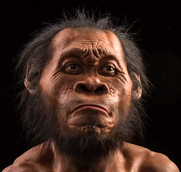
Good illustrations of self publicity and soaring ambition are the private space programmes of oligarchs Elon Musk (SpaceX), Jeff Bezos (Blue Origin) and Richard Branson (Virgin Galactic). For a cool US$65 million a ‘civilian’ can get a trip to the International Space Station on SpaceX; a one-hour suborbital flight on Blue Origin will cost US$300,000, with luck having Bezos as a companion; a reservation on Virgin Galactic for a 1 hour trip to the ‘edge of space’ (~100 km up) now costs US$624,000. It’s a tourist trip for the very, very rich only … but even the long-dead can go … or bits of them. On 8 September 2023 aboard Virgin Galactic flight Tim Nash, a South African billionaire had in his pocket a sturdy tube containing a thumb bone of Homo nalediand the collarbone of Australopithecus sediba. Nash reportedly said afterwards, “I am humbled and honoured to represent South Africa and all of humankind as I carry these precious representations of our collective ancestors”.
Reconstructed head of a somewhat annoyed Homo naledi. Credit: John Gurche, Mark Thiessen, National Geographic.
Nash was entrusted with these unique fossils by Lee Berger, Professor in Palaeoanthropology at Witwatersrand University, South Africa and a National Geographic Explorer-in-Residence. Berger recovered fossils of both species from limestone caves in the UNESCO World Heritage Site grandly named the Cradle of Humankind near Johannesburg. He is no stranger to controversy, and this venture cooked up with Nash seems to aim at promotion of South African achievements rather than having any scientific purpose. It has backfired spectacularly (see: McKie, R. 2023. ‘Callous, reckless, unethical’: scientists in row over rare fossils flown into space. The Observer, 22 October 2023). Comments from the anthropological world, six national and international bodies and perhaps the leading hominin specialist Professor Chris Stringer of the Natural History Museum in London include the words and phrases “callous”, “unethical”, “extraordinarily poorly thought-out”, “a publicity stunt”, “reckless” and “utterly irresponsible”. The caper breaks the South African, indeed international, scientific rule that fossils can only be allowed to travel for scientific purposes, applied consistently by similarly hominin-rich African countries such as Ethiopia, Kenya and Tanzania.
But, Hey, that’s how you get on in the world … isn’t it?
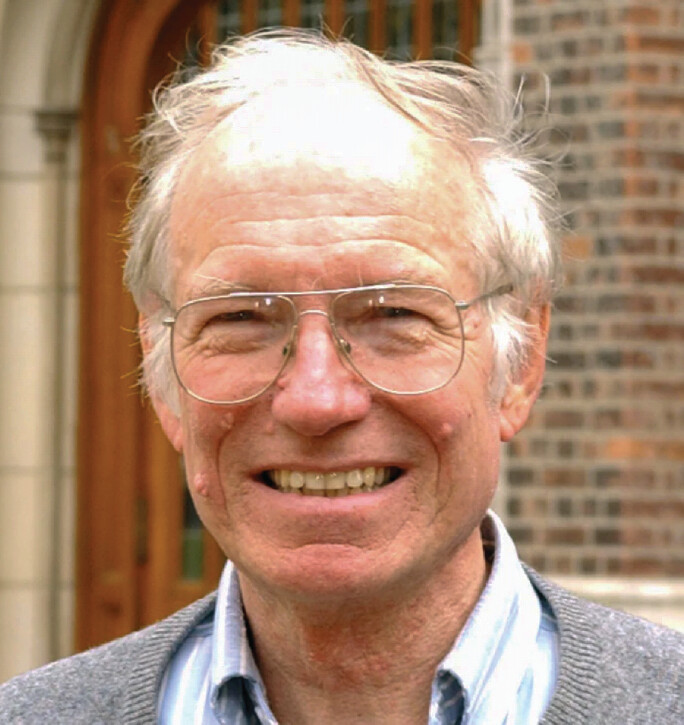
The theory of plate tectonics had a long gestation. Continental drift, one of its central tenets, was first proposed by the meteorologist Alfred Wegener in 1912. Apart from a few enthusiasts of such a dynamic aspect of geology, such as Alex du Toit and Arthur Holmes, the majority of geoscientists remained with the non-revolutionary fixist ideology of their Victorian predecessors. Wegener’s stumbling block was his proposed driving mechanism – polflucht (flight from the poles) – which assumed that supercontinents had formed in polar regions to be subject to centrifugal force resulting from Earth’s rotation. This broke them apart to be driven towards the Equator. Such a mechanism being easily invalidated, most contemporary geologists preferred to ‘throw Wegener’s baby out with the bathwater’. Yet every piece of his evidence that continents had moved around and most of his ideas about the nature of their movements were steadily verified and amplified over the next six decades, which attracted more curious and flexible scientists. What is now the central paradigm of the Earth Sciences had to wait for a set of major discoveries in the 1950s and ‘60s enabled by emerging technologies, such as the magnetometers used by Fred Vine and Drummond Matthews to discover sea-floor magnetic striping and thus sea-floor spreading. Their breakthrough presented a plausible mechanism for continental drift and launched a near frenzy of collaborative research among a global milieu of young geoscientists, one of whom being W. Jason Morgan.
W. Jason Morgan outside the Department of Earth Sciences, Princeton University. (Credit: Denise Applewhite, Princeton University)
His initial interest was in the great fracture zones on the floors of the Atlantic and Pacific Oceans. He grasped that each of them was very nearly a great circle. This was a central key to unifying seafloor spreading and continental drift – to move across a spherical surface every point on the seafloor had to follow such a path. Morgan recognised that the fracture zones could only result from rigid plates having to fracture to accommodate that motion. Using spherical geometry he was able to link together ridges, trenches and these huge transform faults with poles of rotation and triple junctions to predict plate motions in a quantitative manner. That insight provided a key to active earthquakes, mountain belts and volcanoes. His scientific unification was a result of genius: in just a few weeks Morgan established the fundamentals of what became known as plate tectonics.
W. Jason Morgan was one of the revolutionaries who made geology dynamic and launched its resurrection from the boring province of damp field workers in anoraks tramping across tracts of extremely puzzling rocks and structures, noses to the ground. He died at the age of 87 on 31 July 2023.
Many readers will have heard the vibration signal of an earthquake, as recorded by a seismometer, and replayed through a speaker: listen to some examples here. They are eerily like the sounds of falling, multi-storey buildings. Scary, especially if you think of the horrors of the devastation in SE Turkiye and NE Syria caused by the 6 February 2023 magnitude 7.8 event on the East Anatolian Fault system
Since P-waves are very like sound waves, audibly converting the one to the other is relatively simple. However, earthquakes are rarely single events, each major one being preceded by foreshocks and followed by aftershocks, both recurring over weeks or months. Highly active areas are characterised by earthquake swarms that can go on continuously, as happens with sea-floor spreading at mid-ocean ridges. In the case of Yellowstone National Park there are continual quakes, but there the seismicity results from magma rising and falling above a superplume. Most of such swarm-quakes are diminutive, so playing the speeded-up signal through a loudspeaker just sounds like a low, tremulous hiss.
Domenico Vicinanza a physicist at the Anglia Ruskin University in Cambridge UK specialises in creating music from complex scientific data, including those from CERN’s Large Hadron Collider in Geneva, to help interpret them. He has recently turned his hand to the Yellowstone earthquake swarm, converting the amplitudes and frequencies of its real-time seismograph to notes in a musical score: listen to the results here. They are surprisingly soothing, perhaps in the manner of the song of the humpback whale used by some to help with their chronic insomnia.
Most people are familiar with the term ‘blood diamonds’, meaning diamonds clandestinely exported from areas infested by the lethal activities of military and paramilitary forces. Indeed such conflicts are often fuelled by the large profits to be made from trading diamonds. One such source was in Sierra Leone during the civil war of 1991-2002. Others include Liberia, Côte d’ Ivoire, Angola and the Democratic Republic of Congo. Like illicit money, gemstones can be ‘laundered’ and find their way into conventional trade. To some extent the blood diamond trade has been slowed down by a programme of certification of packaged uncut diamond ‘rough’ by bona fide producers, and banning the sale of uncertified rough. The Kimberley Programme has been criticised because certificates can be issued in corrupt ways, so that blood diamonds probably still make their way to the international diamond markets: certification may hold no fears for those who force people to ine at gun point. However, because diamonds often show geochemical signatures and minute inclusions of other minerals that are unique to individual pipe-like intrusions of kimberlite that carry deep-mantle material to the surface. So, it is technically possible – but costly – to check for suspect rough. Such controls do not apply to other gemstones. A major source of very-high value gems is Myanmar (formerly Burma), whose widely condemned military dictatorship may be engaged in their unethical trade, including smuggling to neighbouring Thailand and China to avoid scrutiny.
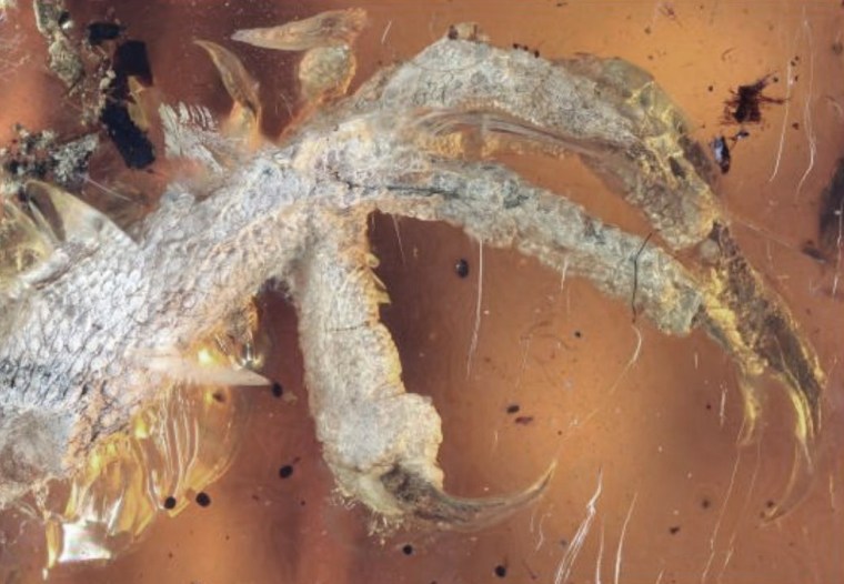
Foot of bird chick preserved in Cretaceous amber from Kachin, Myanmar. Credit: Pinterest, Xing Lida, China University of Geosciences)
Myanmar is well endowed with sedimentary deposits that contain amber, the solidified resin from a variety of now extinct trees. Oddly, completely clear amber has low intrinsic value: it is semi-precious, albeit attractive. But it often contains inclusions of vegetation fragments, insects, feathers and small vertebrates, of interest to palaeontologists. Myanmar amber is especially interesting as it is dated to the Middle Cretaceous (~130 Ma), older than that found around the Baltic Sea (Eocene ~44 Ma), which was the main source for European jewellery since the 12th century, and that from Canada (Upper Cretaceous ~80 Ma). Myanmar amber has been used decoratively and medicinally in China since the 3rd century CE, and in Europe since prehistoric times. It is attractive but quite common, so historically amber never commanded high prices but was widely used as a trade item. Since the publicity attending the supposed extraction of dinosaur DNA from the bodies of reptile parasites to resurrect dinosaurs in Steven Spielberg’s 1993 film Jurassic Park, public and scientific interest in amber has boomed. It is primarily the exquisite preservation of encased organisms that piques the interest of palaeontologists. Papers that rely on the Myanmar amber have grown in number over the last ten years, despite the country being infamous for military repression of tribal and religious groups in its rural areas.
One of the most conflict-riven areas is the northern state of Kachin where the most interesting amber to palaeontologists is collected by the Kachin people of the Hukawng Valley. Government forces have been in conflict with the Kachin Independence Army since the 1960s, most particularly for control of the amber industry. A recent paper has focussed on the ethical issue of publications based on fossil-bearing amber from the area (Dunne, E.M. et al. 2022. Ethics, law, and politics in palaeontological research: The case of Myanmar amber. Communications Biology, v. 5, article no. 1023; DOI: 10.1038/s42003-022-03847-2).
In 2010 the military began forcibly to take over mines in Kachin. Between 2014 and 2021 the annual number of publication underwent a tenfold growth from between 10 to 15 to over 150, despite the fact that in 2015 the government in Yangon prohibited removal of fossils from the country. But the export laws exempt gemstones, so the growing demand for fossiliferous amber is clearly reflected in its supply to foreign scientists. Rare specimens that include vertebrate remains command prices up to US$100,000. The Myanmar amber trade is now estimated at around US$ 1 billion per annum. The Myanmar military took over all the mines in 2017, and is clearly the main supplier to palaeontologists.
In the seven-year period, only 3 papers out of 872 included contributors from Myanmar, which also suggests an element of ‘parachute science’: unsurprisingly Myanmar-based scientists also find it difficult to visit the Kachin area. Before 2014 most of the 69 publications involved scientists in the US; since then, the top spot has been occupied by Chinese scientists who have amassed 417. It seems clear that there is a web of contacts linking together the source of Myanmar amber, its market and science. In 2020 the Society of Vertebrate Paleontology called for a moratorium on publishing data from Kachin sources. But since then there is little sign that palaeontologists have taken any notice.
In November 2019 the Conservative government of Boris Johnson declared a moratorium on development of shale gas by hydraulic fracturing (‘fracking’) in England. This followed determined public protests at a number of potential fracking sites, the most intransigent being residents of Lancashire’s Fylde peninsula. They had been repeatedly disturbed since mid 2017 by low-magnitude earthquakes following drilling and hydraulic-fluid injection tests by Cuadrilla Resources near Little Plumpton village. Their views were confirmed in a scientific study by the British Geological Survey for the Oil and Gas Authority that warned of the impossibility of predicting the magnitude of future earthquakes that future fracking might trigger. The shale-gas industry of North America, largely in areas of low population and simple geology, confirmed the substantial seismic hazard of this technology by regular occurrences of earthquakes up to destructive magnitudes greater than 5.0. The Little Plumpton site was abandoned and sealed in February 2022.
Cuadrilla’s exploratory fracking site near Little Plumpton in Fylde, Lancashire. (Credit: BBC)
On 22 September 2022 the moratorium was rescinded by Jacob Rees-Mogg, Secretary of State for Business, Energy and Industrial Strategy in the new government of Liz Truss, two weeks after his appointment. This was despite the 2019 Conservative manifesto pledging not to lift the moratorium unless fracking was scientifically proven to be safe. His decision involved suggesting that the seismicity threshold for pausing fracking operations be lifted from magnitude 0.5 to 2.5, which Rees-Mogg claimed without any scientific justification to be ‘a perfectly routine natural phenomenon’. He further asserted that opposition to fracking was based around ‘hysteria’ and public ignorance of seismological science, and that some protestors had been funded by Vladimir Putin. In reality the Secretary of State’s decision was fuelled by the Russian Federation’s reducing gas supplies to Europe following its invasion of Ukraine, the soaring world price of natural gas and an attendant financial crisis. There was also a political need to be seen to be ‘doing something’, for which he has a meagre track record in the House of Commons. Rees Mogg claimed that lifting the moratorium would bolster British energy security. That view ignored the probable lead time of around 10 years before shale gas can become an established physical resource in England. Furthermore, an August 2018 assessment of the potential of UK shale-gas, by a team of geoscientists, including one from the British Geological Survey, suggested that shale-gas potential would amount to less than 10 years supply of UK needs: contrary to Rees-Mogg’s claim that England has ‘huge reserves of shale’. Indeed it does, but the vast bulk of these shales have no commercial gas potential.
Ironically, the former founder of Cuadrilla Resources, exploration geologist Chris Cornelius, and its former public affairs director, Mark Linder, questioned the move to unleash fracking in England, despite supporting shale-gas operations where geologically and economically appropriate. Their view is largely based on Britain’s highly complex geology that poses major technical and economic challenges to hydraulic fracturing. Globally, fracking has mainly been in vast areas of simple, ‘layer-cake’ geology. A glance at large-scale geological maps of British areas claimed to host shale-gas reserves reveals the dominance of hundreds of faults, large and small, formed since the hydrocarbon-rich shales were laid down. Despite being ancient, such faults are capable of being reactivated, especially when lubricated by introduction of fluids. Exactly where they go beneath the surface is unpredictable on the scales needed for precision drilling. Many of the problems encountered by Cuadrilla’s Fylde programme stemmed from such complexity. Over their 7 years of operation, hundreds of millions of pounds were expended without any commercial gas production. Each prospective site in Britain is similarly compartmentalised by faulting so that much the same problems would be encountered during attempts to develop them. By contrast the shales fracked profitably in the USA occur as horizontal sheets deep beneath entire states: entirely predictable for the drillers. In Britain, tens of thousands of wells would need to be drilled on a ‘compartment-by-compartment’ basis at a rate of hundreds each year to yield useful gas supplies. Fracking in England would therefore present unacceptable economic risks to potential investors. Cornelius and Linder have moved on to more achievable ventures in renewables such as geothermal heating in areas of simple British geology.
Jacob Rees-Mogg’s second-class degree in history from Oxford and his long connection with hedge-fund management seem not to be appropriate qualifications for making complex geoscientific decisions. Such a view is apparently held by several fellow Conservative MPs, one of whom suggested that Rees-Mogg should lead by example and make his North East Somerset constituency the ‘first to be fracked’, because it is underlain by potentially gas-yielding shales. The adjoining constituency, Wells, has several sites with shale-gas licences but none have been sought within North East Somerset. Interestingly, successive Conservative governments since 2015, mindful of a ‘not-in-my-backyard’ attitude in the party’s many rural constituencies, have placed a de-facto ban on development of onshore wind power.
I don’t often review books on Earth-logs, but one that is pending publication may interest readers (Ian Francis, Stuart Holmes and Bruce Yardley 2022. The Lake District: Landscape and Geology. Marlborough: The Crowbrook Press; ISBN: 078 0 7198 4011 1). Ian Francis urged me to create Earth Pages, the predecessor to Earth-logs. One good turn deserves another, but this is a very good book. Unlike nearly all area-specific geoscientific books it is not primarily a guidebook. Instead it uses the internationally famous Lake District as a means of teaching how to fathom what a landscape represents. In this case, one with a history going back half a billion years, involving closure of an ocean, destruction of a mountain chain and sediment deposition in a ‘shallow, inland sea’. The last couple of million years or so of cycles of glaciation and river erosion have sculpted its present form. Finally, it became the home range of human hunter gatherers, once the ice had melted away around 10 thousand years ago. Britain’s first stone-age tillers and herders colonised its lower elevations, followed by miners and metal smelters, Roman, Viking and Anglo Saxon invaders and settlers. Its beauty and complexity have inspired poets and artists, and they in turn have drawn in more visitors per km2 than perhaps any other National Park on Earth, and far more per annum than its indigenous population.
Cover of The Lake District: Landscape and Geology
Ian, Stuart and Bruce lace their book with some of the best landscape images of the Lake District that I have come across, which invite you to read the text. The Lake District is pitched at a level that anyone can understand, with a minimum of jargon and a pleasant style. Basic geological concepts are covered in separate ‘boxes’, where the main thread requires them and for those who want a little more science. Geology being an observational science, there is some emphasis on indicators of natural processes, such as elliptical drumlins whose sculpting by flowing ice aligns their long axes, and exotic boulders made of rocks only present miles away whose presence suggests the source of the ice that had moved them. Solid rock outcrops in the Lakes are products of many Earth processes, both internal and at the former surface. There are granitic rocks that intruded through once volcanic and sedimentary rocks. Their internal features tell the rocktypes apart, such as the layering of sediments, often cleaved and folded by deformation. and the lack of structure in granite that cuts the layering, yet imparts new minerals to the older marine rocks as a result of igneous heating to very high temperatures.
Most of the geological concepts raised in the main text are amplified by narratives of seven field trips; provided the reader physically walks through them. And why shouldn’t they? Each of them involves only a few kilometres of gentle walking from parking spaces on metalled roads. They cover all the solid geology, from the regionally oldest rocks, the Early-Ordovician, deep-water Skiddaw Slates; upwards in geological time through the varied products of later Ordovician volcanism and marine sediments; the thick Silurian mudstones and silts; and the youngest and structurally simplest shallow-marine Carboniferous limestone. The sediments all contain fossils and the volcanics are full of evidence of the environment onto which they poured – an oceanic island arc. A simple story is unveiled by all, such as following a track on the flanks of Blencathra, a hill in the Northern Fells. From slates with cleavage formed by compressive forces acting on muds; to a point where new minerals have grown in them through later heating; then to where heat was so intense that the slates came to resemble igneous rocks; and finally outcrops of a granite whose much later intrusion as magma explains the simple sequence. All the trips are like that: not too much to take in, but enough to hammer home the various rudiments of geology.
Britain was where the modern Earth sciences were largely forged. But that was in the absence of complete exposure of all the solid rock that underpins it. What lies between outcrops is the modern natural world and a diversity of ecosystems to which The Lake District also draws attention. Even professional geologists get bored to tears by trudging unendingly over nothing but rock. They enjoy flowers, trees, birds, streams and tarns with fish as a relief. Some of the text also taught me about oddities created by Cumbrian farmers: bields, which are shelters for shepherds and sheep; washfolds where sheep used to be gathered and cleaned prior to shearing, and lots more about the unique upland farming culture of Cumbria. I hope the book proves physically durable, for it will surely find its way into secondary-school and first-year undergraduate field trips. It is also ideal for any family aiming at a fortnight’s holiday in the Lakes, but wondering what to do. The book will get well-thumbed and wet – the one drawback of the Lake District is its annual rainfall, averaging 3.3 metres! Go in April, May or early June to escape the worst of it and that of tourists, and to see its ecology at its best. I’m giving my complimentary copy to my grandchildren, because I get annoyed when they complain of boredom!
The Vattenfall lignite mine in Germany; the Anthropocene personified
The issue of whether or not to assign the time span during which human activities have been significantly affecting the planet and its interwoven Earth Systems has been dragging on since the term ‘Anthropocene’ was first proposed more than two decades ago. A suggestion that may resolve matters, both amicably and with a degree of scientific sense, has emerged in a short letter to the major scientific journal Nature, written by six eminent scientists (Bauer, A.M. et al. 2021. Anthropocene: event or epoch? Nature, v. 597, p. 332; DOI: 10.1038/d41586-021-02448-z). The full text is below
“The concept of the Anthropocene has inspired more than two decades of constructive scholarship and public discussion. Yet much of this work seems to us incompatible with the proposal to define the Anthropocene as an epoch or series in the geological timescale, with a precise start date and stratigraphic boundary in the mid-twentieth century. As geologists, archaeologists, environmental scientists and geographers, we have another approach to suggest: recognize the Anthropocene as an ongoing geological event.
The problems with demarcating the Anthropocene as a globally synchronous change in human–environment relations, occurring in 1950 or otherwise, have long been evident (P. J. Crutzen and E. F. Stoermer IGBP Newsletter41, 17–18; 2000). As an ongoing geological event, it would be analogous to other major transformative events, such as the Great Oxidation Event (starting around 2.4 billion years ago) or the Great Ordovician Biodiversification Event (around 500 million years ago).
Unlike formally defined epochs or series, geological events can encompass spatial and temporal heterogeneity and the diverse processes — environmental and now social — that interact to produce global environmental changes. Defining the Anthropocene in this way would, in our view, better engage with how the term has been used and criticized across the scholarly world.”
AUTHORS: Andrew M. Bauer, Stanford University, Stanford, California, USA; Matthew Edgeworth, University of Leicester, Leicester, UK; Lucy E. Edwards, Florence Bascom Geoscience Center, Reston, Virginia, USA; Erle C. Ellis, University of Maryland, Baltimore County, Maryland, USA ; Philip Gibbard, Scott Polar Research Institute, University of Cambridge, Cambridge, UK; Dorothy J. Merritts, Franklin and Marshall College, Lancaster, Pennsylvania, USA.
I have been grousing about the attempt to assign Epoch/Series status to the Anthropocene for quite a while (you can follow the development of my personal opinions by entering ‘Anthropocene’ in the Search Earth-logs box). In general I believe that the proposal being debated is scientifically absurd, and a mere justification for getting a political banner to wave. What the six authors of this letter propose seems eminently sensible. I hope it is accepted by International Commission on Stratigraphy as a solution to the increasingly sterile discussions that continue to wash to and fro in our community. Then perhaps the focus can be on action rather than propaganda.
As things have stood since 21 May 2019, a proposal to accept the Anthropocene as a formal chrono-stratigraphic unit defined by a GSSP at its base around the middle of the 20th century is before the ICS and the International Union of Geological Sciences (IUGS) for ratification. It was accepted by 88% of the 34-strong Anthropocene Working Group of the ICS Subcommission on Quaternary Stratigraphy. But that proposal has yet to be ratified by either the ICS or IUGS. Interestingly, one of the main Anthropocene proponents was recently replaced as chair of the Working Group.
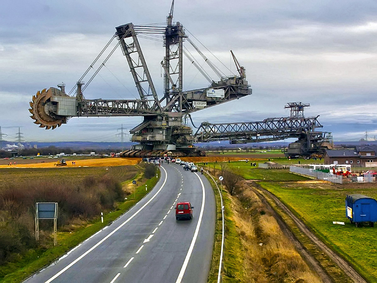
The Bagger 288 bucket wheel reclaimer moves from one lignite mine to another in Germany: an apt expression of modern times
Followers of Earth-logs and its predecessor, should be familiar with the concept of ‘The Anthropocene’. More recent readers can hardly have escaped it, for it has become a recurrent motif that extends far beyond science to the media, the social sciences and even the arts. Some circles among the ‘chattering classes’ speak of little else. It has become a trope – a word with figurative or metaphorical meaning. In 2000, atmospheric chemist and Nobel Laureate Paul Crutzen suggested that the increasingly clear evidence that human society is having growing impacts on the Earth system should be recognised by a new stratigraphic Epoch. Some Fellows of the Geological Society of London launched an attempt to formalise the suggestion through the society’s Stratigraphic Commission (Zalasiewicz, J. and 20 others 2008. Are we now living in the Anthropocene?GSAToday, v.18(ii), p. 4-8; DOI: 10.1130/GSAT01802A.1). In 2009 Jan Zalasiewicz of the University of Leicester became the first chair of the Anthropocene Working Group (AWG) within the International Commission on Stratigraphy (ICS). A dozen years on, stratigraphers continue to debate the Anthropocene (See: Brazil, R. 2021. Marking the Anthropocene. Chemistry World, 29 January 2021). One of the problems facing its supporters is the lack of agreement about what it is and when it started.
Since 1977 the ICS has been searching for localities, known as Global Boundary Stratotype Sections and Points, or GSSPs, that mark the actual beginning of each basic division of the geological record: Eons, Eras, Periods, Epochs and Ages. So far, those for Epochs and longer divisions have been agreed and GSSP markers have been cemented in place, sometimes with quite large monuments, if not actual golden spikes. Those for the shortest timespans – Ages – are proving more difficult to agree on. These GSSPs have to have global significance, yet the very nature of stratigraphy means that a fair number of the most brief rock sequences revealed by field work either formed at different times across the globe, or there is no incontrovertible dating method to record their beginning and end.
Currently, we live in the Holocene Epoch whose beginning marked the global climate system’s exit from the frigid Younger Dryas at 11.7 ka ago. The Holocene (‘entirely recent’) Epoch marks the latest interglacial. When it began every human being was Homo sapiens, made a living as a hunter-gatherer and eventually expanded into every ecosystem that offered sustenance on all continents bar Antarctica. Within a few thousand years some began sedentary life as farmers and herders after their domestication of a range of plant and animal species. A few millennia later agriculture had a growing foothold everywhere except in Australia. Natural tree cover began to be cleared and organised grazing steadily changed other kinds of ecosystem. Human influences, other than scattered artefacts and bones, became detectable in geological formations such as lake-bed sediments and peat mires. The geological record of the Holocene is by no means consistent globally, there being lots of gaps. That is partly because sedimentary systems continually deposited, eroded and transported sediments on the landmasses. In the tropics and much of the Southern Hemisphere the Younger Dryas is, in any case, barely recognisable in post-Ice Age deposits, so the start of the Holocene there is vague. Things are simpler on the deep sea floor, as muds accumulate with no interruption. But it was only when data became available from drill cores through continental ice masses on Antarctica, Greenland and scattered high mountains that any detailed sense of changes and their pace emerged. The major climatic perturbation of the Younger Dryas and its end only became clear from the undisturbed annual layering in Greenland ice cores. It proved to have been extremely fast: a couple of decades at most. The GSSP for the start of the Holocene therefore lies in a single Greenland ice core preserved by cold storage in Copenhagen. It is a somewhat ephemeral record.
Leaving aside for the moment that the Anthropocene adds the future to the geological record, when was it supposed to start? Its name demands that it be linked to some human act that began to change the world. That is implicit in the beginning of agriculture which held out the prospect of continuous growth in human populations by securing food resources rather than having to seek them. But such an event is not so good from the standpoint of purist stratigraphy as it happened at different times at different places and probably for different reasons (See: Mithen, S. 2004. After the Ice: A Global Human History, 20,000 – 5000 BC. Weidenfeld and Nicolson, London; ISBN-13: 978-0753813928 [A superb read]). A case has been made for the European conquest and colonisation of the Americas which was eventually followed by the death from European diseases of tens of millions of native people, many of whom were farmers in the Amazon basin. The Greenland ice records a decline in atmospheric CO2 between 1570 to 1620 CE, which has been ascribed to massive regrowth of previously cleared tropical rainforest. That would define a start for the Anthropocene at around 1610 CE. Yet the main driver for erecting an Anthropocene Epoch is global warming, which has grown exponentially with the burning of fossil fuels and CO2 emissions since the ill-defined start of the Industrial Revolution (late 18th – early 19th century). It looks like in a year or so the ICS is due to debate a much later start at the peak of nuclear weapon fallout in 1964, which its champions claim to coincide with the ‘Great Acceleration’ in world economic growth, emissions and warming.
If that is accepted, anyone still alive who was born before 1964 is a relic of the Holocene, as Philip Gibbard secretary-general of ICS wryly observed, whereas our children and grandchildren will be wholly of the Anthropocene. We Holocene relics only grasped the change at the start of the 21st century! The very nature of exponential growth is that its tangible effects always come as a surprise. The build-up of human influence on the world has been proceeding stealthily since not long after the Holocene began. Annoyingly, the very name Anthropocene lays the blame on the whole of humanity. In reality it is an outcome of a mode of economy that demands continual exponential growth. That mode – the World Economy – lies completely beyond the reach of social and political control. It is effectively inhuman. So, why the pessimism – can’t human beings get rid of an ethos that is obviously alien to their interests? Perhaps ‘Anthropocene’ might be an apt name for the aftermath of such a reckoning, which may last long enough to be properly regarded as an Epoch …
I last wrote about sedimentation during the ‘Anthropocene’ a year ago (See: Sedimentary deposits of the ‘Anthropocene’, November 2019). Human impact in that context is staggeringly huge: annually we shift 57 billion tonnes of rock and soil, equivalent to six times the mass of the UKs largest mountain, Ben Nevis. All the world’s rivers combined move about 35 billion tonnes less. I don’t particularly care for erecting a new Epoch in the Stratigraphic Column, and even less about when the ‘Anthropocene’ is supposed to have started. The proposal continues to be debated 12 years after it was first suggested to the IUGS International Commission on Stratigraphy. I suppose I am a bit ‘old fashioned’, but the proposals is for a stratigraphic entity that is vastly shorter than the smallest globally significant subdivision of geological time (an Age) and the duration of most of the recorded mass extinctions, which are signified by horizontal lines in the Column. By way of illustration, the thick, extensive bed of Carboniferous sandstone on which I live is one of many deposited in the early part of the Namurian Age (between 328 and 318 Ma). Nonetheless, anthropogenic sediments of, say, the last 200 years are definitely substantial. A measure of just how substantial is provided by a paper published online this week (Kemp, S.B. et al. 2020. The human impact on North American erosion, sediment transfer, and storage in a geologic context. Nature Communications, v. 11, article 6012; DOI: 10.1038/s41467-020-19744-3).
‘Badlands’ formed by accelerated soil erosion.
Anthropogenic erosion, sediment transfer and deposition in North America kicked off with its colonisation by European immigrants since the early 16th century. First Americans were hunter-gatherers and subsistence farmers and left virtually no traces in the landscape, other than their artefacts and, in the case of farmers, their dwellings. Kemp and colleagues have focussed on late-Pleistocene alluvial sediment, accumulation of which seems to have been pretty stable for 40 ka. Since colonisation began the rate has increased to, at present, ten times that previously stable rate, mainly during the last 200 years of accelerated spread of farmland. This is dominated by outcomes of two agricultural practices – ploughing and deforestation. Breaking of the complex and ancient prairie soils, formerly held together by deep, dense mats of grass root systems, made even flat surfaces highly prone to soil erosion, demonstrated by the ‘dust bowl’ conditions of the Great Depression during the 1930s. In more rugged relief, deforestation made slopes more likely to fail through landslides and other mass movements. Damming of streams and rivers for irrigation or, its opposite, to drain wetlands resulted in alterations to the channels themselves and their flow regimes. Consequently, older alluvium succumbed to bank erosion. Increased deposition behind an explosion of mill dams and changed flow regimes in the reaches of streams below them had effects disproportionate to the size of the dams (see: Watermills and meanders, March 2008). Stream flow beforehand was slower and flooding more balanced than it has been over the last few hundred years. Increased flooding, the building of ever larger flood defences and an increase in flood magnitude, duration and extent when defences were breached form a vicious circle that quickly transformed the lower reaches of the largest American river basins.
North American rates of alluvium deposition since 40 Ka ago – the time axis is logarithmic. (Credit: Kemp et al., 2020; Fig. 2)
All this deserves documentation and quantification, which Kemp et al. have attempted at 400 alluvial study sites across the continent, measuring >4700 rates of sediment accumulation at various times during the past 40 thousand years. Such deposition serves roughly as a proxy for erosion rate, but that is a function of multiple factors, such as run-off of rain- and snow-melt water, anthropogenic changes to drainage courses and to slope stability. The scale of post-settlement sedimentation is not the same across the whole continent. In some areas, such as southern California, the rate over the last 200 years is lower than the estimated natural, pre-settlement rate: this example may be due to increased capture of surface water for irrigation of a semi-arid area so that erosion and transport were retarded. In others it seems to be unchanged, probably for a whole variety of reason. The highest rates are in the main areas of rain-fed agriculture of the mid-west of the US and western Canada.
In a nutshell, during the last century the North American capitalism shifted as much sediment as would be moved naturally in between 700 to 3000 years. No such investigation has been attempted in other parts of the world that have histories of intense agriculture going back several thousand years, such as the plains of China, northern India and Mesopotamia, the lower Nile valley, the great plateau of the Ethiopian Highlands, and Europe. This is a global problem and despite its continent-wide scope the study by Kemp et al. barely scratches the surface. Despite earnest endeavours to reduce soil erosion in the US and a few other areas, it does seem as if the damage has been done and is irreversible.
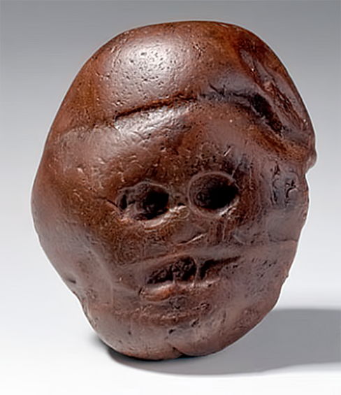
Maybe because of the Covid-19 pandemic, there has been a dearth of interesting new developments in the geosciences over that last few months: the ‘bread and butter’ of Earth-logs. So instead of allowing a gap in articles to develop, and as a sign that I haven’t succumbed, this piece concerns one of the most intriguing discoveries in palaeoanthropology. In 1925 Wilfred Eitzman, a school teacher, investigated a cave in the Makapansgat Valley in Limpopo Province, South Africa that had been exposed by quarry workers. His most striking discovery was a polished pebble made of very fine-grained, iron-rich silica, probably from a Precambrian banded iron formation. Being round and deeply pitted, it had clearly been subject to prolonged rolling and sand blasting in running water and wind. Eerily, whichever way it was viewed it bore a striking resemblance to a primate face: eyes, mouth, nose and, viewed from the rear, a disturbing, toothless grin. We have all picked up odd-looking pebbles on beaches or a river bank: I recently found a sandstone demon-cat (it even has pointy ears) when digging a new vegetable patch.
The Makapansgat Pebble. Inverted it still resembles a face and its obverse side does too.
What is different about the Makapansgat Pebble is that Eitzman found it in a cave-floor layer full of bones, including those of australopithecines. The cave is located in dolomitic limestone outcrops high in the local drainage system, so it’s unlikely that the pebble was washed into it. The nearest occurrence of banded iron formation is about 20 kilometres away, so something must have carried the pebble for a day or more to the cave. The local area has since yielded a superb palaeontological record of early hominin evolution, stimulated by Eitzman’s finds. He gave the fossils and the pebble to Raymond Dart, the pioneer of South African palaeoanthropology. Dart named the hominin fossils Australopithecus prometheus because associated bones of other animals were covered in black stains that Dart eagerly regarded as signs of burning and thus cooking. When it became clear that the stains were of manganese oxide the name was changed to Au. africanus, the fossils eventually being dated to around 3 million years ago.
Dart was notorious for his showmanship, and the fossils and the Makapansgat Pebble ‘did the rounds’ and continue to do so. In 2016 the pebble was displayed with a golden rhino, a collection of apartheid-era badges and much more in the British Museum’s South Africa: the art of a nation exhibition. Well, is the pebble art? As it shows no evidence of deliberate working it can not be considered art, but could be termed an objet trouvé. That is, an ‘object found by chance and held to have aesthetic value to an artist’. The pebble’s original finder 3 million years ago must have found the 0.25 kg pebble sufficiently interesting to have carried it back to the cave, presumably because of its clear resemblance to a hominin head: in fact a multiple-faced head. Was it carried by a cave-dwelling australopithecine or an early member of genus Homo who left no other trace at Makapansgat? At an even earlier time a so-far undiscovered hominin did indeed make simple stone toolsto dismember joints of meat on the shores of Lake Turkana in Kenya. It is impossible to know who for sure carried the pebble, nor to know why. Yet all living primates are curious creatures, so it is far from impossible that any member of the hominins in our line of descent would have collected portable curiosities.
In 1994 Clark Chapman of the Planetary Science Institute in Arizona and David Morrison of NASA’s Ames Research Center in California published a paper that examined the statistical hazard of death by unnatural causes in the United States (Chapman, C. & Morrison, D. 1994. Impacts on the Earth by asteroids and comets: assessing the hazard. Nature, v. 367, p. 33–40; DOI:10.1038/367033a0). Specifically, they tried to place the risk of an individual being killed by a large asteroid (~2 km across) hitting the Earth in the context of more familiar unwelcome causes. Based on the then available data about near-Earth objects – those whose orbits around the Sun cross that of the Earth – they assessed the chances as ranging between 1 in 3,000 and 1 in 250,000; a chance of 1 in 20,000 being the most likely. The results from their complex calculations turned out to be pretty scary, though not as bad as dying in a car wreck, being murdered, burnt to death or accidentally shot. Asteroid-risk is about the same as electrocution, at the higher-risk end, but significantly higher than many other causes with which the American public are, unfortunately, familiar: air crash; flood; tornado and snake bite. The lowest asteroid-risk (1 in 250 thousand) is greater than death from fireworks, botulism or trichloroethylene in drinking water; the last being 1 in 10 million.
Chapman and Morrison cautioned against mass panic on a greater scale than Orson Welles’s 1938 CBS radio production of H.G. Wells’s War of the Worlds allegedly resulted in. Asteroid and comet impacts are events likely to kill between 5,000 and several hundred million people each time they happen but they occur infrequently. Catastrophes at the low end, such as the 1908 Tunguska air burst over an uninhabited area in Siberia, are likely to happen once in a thousand years. At the high end, mass extinction impacts may occur once every hundred million years. As might be said by an Australian, ‘No worries, mate’! But you never know…
Michelle Knapp’s Chevrolet Malibu the morning after a stony-iron mmeteorite struck it. Bought for US$ 300, Michelle sold the car for US$ 25,000 and the meteorite fetched US$ 50,000 (credit: John Bortle)
How about ordinary meteorites that come in their thousands, especially when the Earth’s orbit takes it through the former paths taken by disintegrating comets? When I was a kid rumours spread that a motor cyclist had a narrow escape on the flatlands around Kingston-upon-Hull in East Yorkshire, when a meteorite landed in his sidecar: probably apocryphal. But Michelle Knapp of Peeskill, New York, USA had a job for the body shop when a 12 kg extraterrestrial object hit her Chevrolet Malibu, while it was parked in the driveway. In 1954, Ann Hodges of Sylacauga, Alabama was less fortunate during an afternoon nap on her sofa, when a 4 kg chondritic meteorite crashed through her house roof, hit a radiogram and bounced to smash into her upper thigh, badly bruising her. For an object that probably entered the atmosphere at about 15 km s-1, that was indeed a piece of good luck resulting from air’s viscous drag, the roof impact and energy lost to her radiogram. The offending projectile became a doorstop in the Hodge residence, before the family kindly donated it to the Alabama Museum of Natural History. Another fragment of the same meteorite, found in a field a few kilometres away, fetched US$ 728 per gram at Christie’s auction house in 2017. Perhaps the most unlucky man of the 21st century was an Indian bus driver who was killed by debris ejected when a meteorite struck the dirt track on which he was driving in Tamil Nadu in 2016 – three passengers were also injured. Even that is disputed, some claiming that the cause was an explosive device.
The issue of erecting a new stratigraphic Epoch encompassing the time since humans had a global effect on the Earth System has irked me ever since the term emerged for discussion and resolution by the scientific community in 2000. An Epoch in a chronostratigraphic sense is one of several arbitrary units that encompass all the rocks formed during a defined interval of time. The last 541 million years (Ma) of geological time is defined as an Eon – the Phanerozoic. In turn that comprises three Eras – Palaeozoic, Mesozoic and Cenozoic. The third level of division is that of Periods, of which there are 11 that make up the Phanerozoic. In turn the Periods comprise a total of 38 fourth-level Epochs and 85 at the fifth tier of Ages. All of these are of global significance, and there are even finer local divisions that do not appear on the International Chronostratigraphic Chart . If you examine the Chart you will find that no currently agreed Epoch lasted less than 11.7 thousand years (the Holocene) and all the others spanned 1 Ma to tens of Ma (averaged at 14.2 Ma). Indeed, even Ages span a range from hundreds of thousands to millions of years (averaged at 6 Ma).
The Vattenfall lignite mine in Germany; the Anthropocene personified
In the 3rd week of May 2019 the 34-member Anthropocene Working Group (AWG) of the International Commission on Stratigraphy (ICS) sat down to decide on when the Anthropocene actually started. That date would be passed on up the hierarchy of the geoscientific community eventually to meet the scrutiny of its highest body, the executive committee of the International Union of Geological Sciences, and either be ratified or not. In the meantime the AWG is seeking a site at which the lower boundary of the Anthropocene would be defined by the science’s equivalent of a ‘golden spike’; the Global boundary Stratotype Section and Point (GSSP). Continue reading “Anthropocene edging closer to being ‘official’”→
Massive open online courses (MOOCs for short) first mooted in 2006, surfaced with something of a pop in 2012. Intended to be open to all with Internet access, they promised a renaissance of higher education with the ’best’ professors, educational technologies and materials, flexibility, innovative assessment and accreditation (if chosen), no entry requirements, and very low cost at a time of relentlessly rising fees for conventional study. And they did not require attendance, although certificates of successful completion may be a currency for acceptance in conventional HE. They could be about literally anything at a variety of levels and involving a range of study times. By the end of 2016 MOOC programs had been set up by more than 700 universities worldwide, and around 58 million students had signed up to one of more courses. The general business model is described as ‘freemium’; i.e. a pricing strategy whereby a product or service is provided free of charge, with a premium charged for certification. There are innumerable variants of this model. The top providers are mainly consortia linking several universities and other academic and cultural entities. Futurelearn, although wholly owned by the formerly world-leading distance-learning distributor the British Open University, has 157 partners in Britain and globally. Its venture into the field involved its investing several tens of million UK pounds at start-up, which some believe was the source of its current financial difficulties.
The 11 January issue of Science published a brief account of the fortunes of a range of MOOC providers (Reich, J. & Ruipérez, J.A. 2019. The MOOC pivot. Science, v. 363, p. 130-131; DOI: 10.1126/science.aav7958) using data from edX that links Harvard University and MIT. The vast majority of learners who chose MOOCs never return after their first year. Growth in the market is concentrated almost entirely in affluent countries, whereas the model might seem tailor-made, and indeed vital, for less fortunate parts of the world. Completion rates are very low indeed, largely as a result of poor retention: since 2012 drop-out rates in the first year are greater than 80%. In the data used in the study both enrollments and certifications from 2012 to last year rose to peaks in the first three years (to 1.7 million and 50 thousand respectively) then fell sharply in the last two years (to <1 million and <20 thousand, respectively). Whatever the ‘mission’ of the providers – was it altruistic or seeking a revenue stream? – the MOOC experience seems to be falling by the wayside. Perhaps many students took MOOCs for self-enlightenment rather than for a credential, as their defenders maintain. Well, the figures suggest that few saw fit to continue the experience. Surely, if knowledge was passed on at a level commensurate with participants requirements in a manner that enthused them, a great many would have signed up for ‘more of the same’: clearly that didn’t happen.
The authors conclude with, ‘Dramatic expansion of educational opportunities to underserved populations will require political movements that change the focus, funding, and purpose of higher education; they will not be achieved through new technologies alone.’