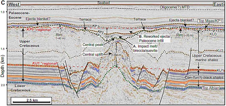
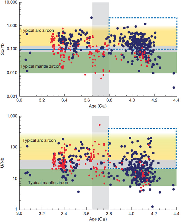
Hydrogen and how the Earth formed

A third piece with hydrogen as its focus in a couple of months? Well, from a galactic perspective there’s a lot of it about. Modern cosmology suggests that only 4.6% of the energy in the universe consists of elemental atoms made of protons, neutrons and electrons, dwarfed by dark energy and dark matter that are something of mystery. But of the more familiar energy equivalent, tangible matter (as in E=mc2), 74% of the universe is hydrogen, 24% is helium and the other 92 elements amount to just 2%. That tiny proportion of heavier elements was created by nucleosynthesis within stars from the two products of the Big Bang (H and He). Nuclear fusion reactions formed those with atomic numbers (protons in their nuclei) up to that of iron (26), whereas the heavier elements were created through neutron- and proton capture when the largest stars destroyed themselves cataclysmically as supernovae. Yet the planet whose surface we inhabit contains only minute amounts of helium and elemental hydrogen. Of course water at and beneath the surface, in the form of atmospheric vapour and locked within minerals retains some of the cosmically available hydrogen. But current estimates suggest that hydrogen accounts for a mere 0.03% of Earth’s mass. Despite the fact that some forms of radioactive decay generate alpha particles that become helium it forms a vanishingly small proportion of terrestrial mass.

The solar system formed around 4.6 billion years ago by a complex gravitational accretion of the gas and dust of an interstellar cloud: mainly H and He. Its dynamic collapse resulted in gravitational potential energy being transformed into heat: in the case of the Sun, sufficient to set off self-sustaining nuclear fusion. As a body grows in this way so does its gravity and thus the speed needed for matter to escape from its pull (escape velocity). As temperature increases so does the speed at which atoms of each element vibrate; the lower the atomic mass the faster the vibration and the greater the chance of escape. So the ‘blend’ of elements that an astronomical body retains during its early evolution depends on its gravity and its surface temperature. The Sun is so massive that very little has escaped its pull, despite a surface temperature of about 5 to 6 thousand degrees Celsius. Its composition is thus close to the cosmic average. Those of the giant planets Jupiter, Saturn, Uranus and Neptune are not far short because of their large gravities and low surface temperatures. Even today, the smaller Inner Planets are unable to cling on to elemental hydrogen and helium and nearly all that is left of the matter from which they formed is the 2% of heavier cosmic elements locked into solids, liquids and gases.

Processes in the early solar system were far more complicated than they are today. In the mainly gaseous disc, from which the solar system evolved, gravity dragged matter towards its centre. That eventually ignited nuclear fusion of hydrogen to form our star. More remote from its gravitational pull vortices aggregated dust into bodies known as planetesimals that in turn accreted to larger protoplanets. Solar gravity dragged gas from the inner solar system leaving rocky protoplanets, whereas gas was able to be attracted to the surface of what became the gas giants where their gravity outweighed that of the far-off Sun. This was complicated by a sort of Milankovich Effect on steroids in which protoplanets continuously changed their orbits and underwent collisions. The best known of these was between the protoEarth and a Mars-sized body that formed the Earth-Moon system, both bodies having deep magma oceans as a result of the huge energy focussed on them by the collision. What may have happened to the protoplanet that became Earth before the Moon-forming collision has been addressed by three geoscientists at the University of California Los Angeles and the Carnegie Institution for Science Washington DC, USA (Young, E.D. et al. 2023. Earth shaped by primordial H2 atmospheres. Nature, v. 616, p. 306–311; DOI: 10.1038/s41586-023-05823-0 [PDF request to: eyoung@epss.ucla.edu]).

A thick hydrogen-rich atmosphere’s interacting chemically with a protoplanet (left). A possible later stage (right) where iron oxide in the magma ocean of the Early Hadean after Moon formation oxidises a hydrogen atmosphere to form surface water (Credit: Sean Raymond 2023, Fig 1)

The focus of the work of Edward Young, Anat Shahar and Hilke Schlichting is directed at the possibility that the Earth-forming protoplanets originally retained thick hydrogen atmospheres. They use thermodynamic modelling of the equilibrium between hydrogen and silicate magma oceans that had resulted from the energy of their accretion. The authors’ main assumption is that insufficient time had elapsed during accretion for the protoplanets to cool and crystallise: a distinct possibility because loss of accretionary heat by thermal radiation would have been ‘blanketed’ by actively accreting dust and gas in orbit around the growing protoplanets. Effectively, the equilibrium would have been chemical in nature: reactions between highly reducing hydrogen and oxidised silicate melts or even vaporised rock evaporated from the very hot surface. The authors suggest that protoplanets bigger than Mars (0.2 to 0.3 times that of Earth) could retain a hydrogen-rich atmosphere long enough for the chemical reactions to come to a balance, despite high temperatures. There would have been no shortage of hydrogen at this early stage in solar system evolution: perhaps as much as 0.2% percent the mass of the Earth surrounding a protoplanet about half its present size.

Two outcomes may have emerged. Reaction between hydrogen and anhydrous silicates could produce H2O in amounts up to three times that currently in the Earth’s oceans, some locked in the magma ocean, some in the dense atmosphere. A by-product would have been iron oxide, giving the current mantle its oxidising properties known from the geochemistry of basaltic magmas.  Hydrogen might also have dissolved in molten iron alloys, thereby contributing to the nascent core. That second outcome would help explain why the modern core is less dense than expected for iron-nickel alloy, both solid and liquid. In fact densities calculated by geophysicists from the speeds of seismic waves that have travelled through the core are 5 to 10% percent lower than expected for the alloy. So the core must contain substantial amounts of elements with low atomic numbers.

Several other possibilities have been suggested to account for Earth’s abundance of water. Two popular ideas are comets arriving in the ‘settled’ times of the Hadean or by original accretion of hydrous chondrite meteorites, whose hydrogen isotope proportions match those of ocean water. Hydrogen as the light element needed in the core is but one possibility along with oxygen, sulfur and other ‘light’ elements. Also, the oxidising potential of the modern mantle may have resulted from several billion years of wet lithosphere being subducted. To paraphrase Sean Raymond (below), ‘other hypotheses are available’!

See also: Raymond, S.N. 2023. Earth’s molten youth had long-lasting consequences. Nature (News & Views), v. 616, p. 251-252; DOI: 10.1038/d41586-023-00979-1 [PDF request to: rayray.sean@gmail.com]

The Moon may have water resources in its soil

Apart from signs of water ice in permanently shadowed areas of some polar craters, the Moon’s surface has generally been considered to be very dry. Rocks returned by the various Apollo missions contain minute traces of water by comparison with similar rocks on Earth. They consist only of anhydrous minerals such as feldspars, pyroxenes and olivines. But much of the lunar surface is coated by regolith: a jumble of rock fragments and dust ejected from a vast number of impact craters over billions of years. It is estimated to be between 3 and 12 m deep. Much of the finer grained regolith is made up of silicate-glass spherules created by the most powerful impacts.

The lunar regolith at Tranquillity Base bearing an astronaut’s bootprint (Credit: Buzz Aldrin, NASA Apollo 11, Photo ID AS11-40-5877)

The scientific and economic (i.e. mining) impetus for the establishment of long term human habitation on the lunar surface hangs on the possibility of extracting water from the Moon itself. It is needed for human consumption and as a source through electrolysis of both oxygen and hydrogen for breathing and also for rocket fuel. The stupendous cost, in both monetary and energy terms, of shifting mass from Earth to the Moon clearly demands self-sufficiency in water for a lunar base occupied for more than a few weeks.

Remote sensing that focussed on the ability of water molecules and hydroxyl (OH) ions to absorb solar radiation with a wavelength of 2.8 to 3.0 micrometres was deployed by the Indian lunar orbiter Chandrayaan-1 that collected data for several months in 2008-9. The results suggested that OH and H2O were detectable over a large proportion of the lunar surface at concentrations estimated at between 10 parts per million (ppm) up to about 0.1%. Where did these hydroxyl ions and water molecules come from and what had locked them up? There are several possibilities for their origin: volcanic activity that tapped the Moon’s mantle (magma could not have formed had some water not been present at great depths); impacts of icy bodies such as comets; even the solar wind that carries protons, i.e. hydrogen atoms stripped of their electrons. Conceivably, protons could react with oxygen in silicate material at the surface to produce both OH and H2O to be locked within solid particles. To assess the possibilities a group of researchers at Chinese and British institutions have examined in detail the 1.7 kg of lunar-surface materials collected and returned to Earth by the 2020 Chinese Chang’e 5 lunar sample return mission (He, H. and 27 others 2023. A solar wind-derived water reservoir on the Moon hosted by impact glass beads. Nature Geoscience, online article; DOI: 10.1038/s41561-023-01159-6)

He et al. focussed on glass spherules formed by impact melting of lunar basalts, whose bulk composition they retain. The glass ‘beads’ contain up to 0.2 % water, mainly concentrated in their outermost parts. This alone suggests that the water and hydroxyl ions were formed by spherules being bathed in the solar wind rather than being of volcanic or cometary origin and trapped in the glass. An abnormally low proportion of deuterium (2H) relative to the more abundant 1H isotope of hydrogen in the spherules is consistent with that hypothesis. Indeed, the high temperatures involved in impact melting would be expected to have driven out any ‘indigenous’ water in the source rocks. The water and OH ions seem to have built up over time, diffusing into the glass from their surfaces rather than gradually escaping from within.

An awful lot of regolith coats the lunar surface, as many of the images taken by the Apollo astronauts amply show. So how much water might be available from the lunar regolith? The Chinese-British team reckon between 3.0 × 10⁸ to 3.0 × 10¹¹ metric tons. But how much can feasibly be extracted at a lunar base camp? The data suggest that a cubic metre (~2 t) of regolith could yield enough to fill 4 shot glasses (~0.13 litres). Using a solar furnace and a condenser – the one in full sunlight the other in the shade – is not, as they say, ‘rocket science’. But for a minimum 3 litres per day intake of fluids per person, a team of 4 astronauts would need to shift and process roughly 100 m3 of regolith every day. Over a year, this would produce a substantial pit. But that assumes all the regolith contains some water, yet the data are derived from the surface alone …See also:Glass beads on moon’s surface may hold billions of tonnes of water, scientists say. The Guardian, 27 March 2023.

Curiosity rover hints at the carbon cycle on Mars

The Mars Science Laboratory carried by the Curiosity rover is still functioning 10 years after a jetpack lowered Curiosity onto the surface of Gale crater. It includes a system aimed at scooping and drilling samples of soil and rock from the sedimentary strata deposited in the lake that once filled the crater about 3.5 to 3.8 billion years ago. The system on the rover is also capable of analysing the samples in various ways. A central objective of the mission was to obtain data on oxygen and carbon isotopes in carbon dioxide and methane released by heating samples, which uses a miniature mass spectrometer. In early 2022 a paper on Martian carbon isotopes was published in the Proceedings of the National Academy of Sciences (PNAS) that I have only just found (House, C.H. et al. 2022. Depleted carbon isotope compositions observed at Gale crater, Mars. Proceedings of the National Academy of Sciences, v. 119, article e2115651119; DOI: 10.1073/pnas.2115651119). PNAS deemed it to be one of the 12 most important of its articles during 2022.

Oblique view of Curiosity’s landing site in Gale crater on Mars, from which the rover has traversed the lower slopes of Mount Sharp. Credit: NASA-Jet Propulsion Laboratory

Carbon isotopic analyses chart the type and degree of fractionation between carbon’s two stable isotopes 12C and 13C. This is expressed by their relative abundances to one another in a sample and in a reference standard, signified by δ13C. The measure is a natural tracer of both inorganic and biological chemical processes: hence the potential importance of the paper by Christopher House and colleagues from the University of California, San Diego. The thin atmosphere of Mars contains both CO2 and traces of CH4, so a carbon cycle is part and parcel of the planet’s geochemical functioning. The ‘big question’ is: Did that involve living processes at any stage in the distant past and even now? Carbon held in various forms within Mars’s ancient rocks and soils may provide at least a hint, one way of the other. At the very least it should say something about the Martian carbon cycle.

House et al. focus on methane released by heating 22 samples drilled from sandstones and mudstones traversed by Curiosity up a slope leading from the floor of Gale crater towards its central peak, Mount Sharp.  The sampled sedimentary rocks span a 0.5 km thick sequence. Carbon in the expelled methane has δ13C values that range from -137 to +22 ‰ (per mil). Samples from six possibly ancient exposed surfaces were below -70 ‰. This depletion in 13C is similar to the highly negative δ13C that characterises carbon-rich sediments on Earth that were deposited at the Palaeocene-Eocene boundary. That anomaly is suspected to have resulted from releases of methane from destabilised gas hydrate on the sea floor during the Palaeocene–Eocene Thermal Maximum. Organic photosynthesis takes up ‘light’ 12C in preference to 13C, thereby imparting low δ13C to organic matter. In the case of the Mars data that might seem to point to the lake that filled Gale crater 3.5 to 3.8 billion years ago has contained living organisms of some kind. Perhaps on exposed surfaces of wet sediment primitive organisms consumed methane and inherited its δ13C. Some Archaean sediments of about the same age on Earth show similar 13C depletion associated with evidence for microbial mats that are attributed to the activities of such methanotrophs.

Before exobiologists become too excited, no images of possible microbial mats in Gale crater sediments have been captured by Curiosity. Moreover, there are equally plausible scenarios with no recourse to once-living organisms that may account for the carbon-isotope data,. Extreme depletion in 13C is commonly found in the carbon within meteorites, almost certainly inherited from the interstellar dust from which they accreted. It is estimated that the solar system passes through giant molecular clouds every 100 Ma or so: the low δ13C may be inherited from interstellar dust. Alternatively, because Mars has an atmosphere almost entirely composed or CO2 – albeit thin at present – various non-biological chemical reactions driven by sunlight or electrically charged particles may have reduced that gas to form methane and other compounds based on C-H bonds. Carbon dioxide still in Mars’s atmosphere is highly enriched in 13C, suggesting that earlier abiotic reduction may have formed 13C-depleted methane that became locked in sediments. Yet such an abundant supply of inorganic methane may have encouraged the evolution of methanotrophs, had life emerged on early Mars. No one knows …

It’s becoming a cliché that, ‘We may have to await the return of samples from the currently active Perseverance rover, or a crewed mission at some unspecifiable time in the future. The Curiosity carbon-isotope data keep the lamp lit for those whose livelihoods have grown around humans going to the Red Planet.

End-Ordovician mass extinction, faunal diversification, glaciation and true polar wander

Enormous events occurred between 460 and 435 Ma around the mid-point of the Palaeozoic Era and spanning the Ordovician-Silurian (O-S) boundary. At around 443 Ma the second-most severe mass extinction in Earth’s history occurred, which eliminated 50 to 60% of all marine genera and almost 85% of species: not much less than the Great Dying at the end of the Permian Period. The event was accompanied by one of the greatest biological diversifications known to palaeontology, which largely replaced the global biota initiated by the Cambrian Explosion. Centred on the Saharan region of northern Africa, Late Ordovician glacial deposits also occur in western South America and North America. At that time all the current southern continents and India were assembled in the Gondwana supercontinent, with continental masses that became North America, the Baltic region, Siberia and South China not far off: all the components that eventually collided to form Pangaea from the Late Silurian to the Carboniferous.

The mass extinction has troubled geologists for quite a while. There are few signs of major volcanism having been involved, although some geochemists have suggested that very high mercury concentrations in some Late Ordovician marine sediments bear witness to large, albeit invisible, igneous events. No large impact crater is known from those times, although there is a curious superabundance of extraterrestrial debris, including high helium-3, chromium and iridium concentrations, preserved in earlier Ordovician sedimentary rocks, around the Baltic Sea. Another suggestion, poorly supported by evidence, is destruction of the atmospheric ozone layer by a gamma-ray burst from some distant but stupendous supernova. A better supported idea is that the oceans around the time of the event lacked oxygen. Such anoxia can encourage solution of toxic metals and hydrogen sulfide gas. Unlike other mass extinctions, this one was long-drawn out with several pulses.

The glacial epoch also seems implicated somehow in the mass die-off, being the only one known to coincide with a mass extinction. It included spells of frigidity that exceeded those of the last Pleistocene glacial maximum, with the main ice cap having a volume of from 50 to 250 million cubic kilometres. The greatest of these, around 445 Ma, involved a 5°C fall in global sea-surface temperatures and a large negative spike in δ13C in carbon-rich sediments, both of which lasted for about a million years. The complex events around that time coincided with the highest ever extinction and speciation rates, the number of marine species being halved in a short space of time: a possible explanation for the δ13 C anomaly. Yet estimates of atmospheric CO2 concentration in the Late Ordovician suggests it was perhaps 8–16 times higher than today; Earth should have been a warm planet then. One probable contributor to extreme glacial conditions has been suggested to be that the South Pole at that time was well within Gondwana and thus isolated from the warming effect of the ocean. So, severe glaciation and a paradoxical combination of mass extinction with considerable biological diversification present quite an enigma.

A group of scientists based in Beijing, China set out to check the palaeogeographic position of South China between 460 and 435 Ma and evaluate those in  O-S sediments at locations on 6 present continents (Jing, X., Yang, Z., Mitchell, R.N. et al. 2022. Ordovician–Silurian true polar wander as a mechanism for severe glaciation and mass extinction. Nature Communications, v. 13, article 7941; DOI: 10.1038/s41467-022-35609-3). Their key tool is determining the position of the magnetic poles present at various times in the past from core samples drilled at different levels in these sedimentary sequences. The team aimed to test a hypothesis that in O-S times not only the entire lithosphere but the entire mantle moved relative to the Earth’s axis of rotation, the ‘slippage’ probably being at the Core-mantle boundary [thanks to Steve Rozario for pointing this out]. Such a ‘true polar wander’ spanning 20° over a mere  2 Ma has been detected during the Cretaceous, another case of a 90° shift over 15 Ma may have occurred at the time when Snowball Earth conditions first appeared in the Neoproterozoic around the time when the Rodinia supercontinent broke up and a similar event was proposed in 1994 for C-O times albeit based on sparse and roughly dated palaeomagnetic pole positions.

Xianqing Jing and colleagues report a wholesale 50° rotation of the lithosphere between 450 and 440 Ma that would have involved speeds of about 55 cm per year. It involved the Gondwana supercontinent and other continental masses still isolated from it moving synchronously in the same direction, as shown in the figure. From 460 to 450 Ma the geographic South Pole lay at the centre of the present Sahara. At 445 Ma its position had shifted to central Gondwana during the glacial period. By 440 Gondwana had moved further northwards so that the South Pole then lay at Gondwana’s southernmost extremity.

Palaeogeographic reconstructions charting true polar wander and the synchronised movement of all continental masses between 460 and 440 Ma. Note the changes in the trajectories of lines of latitude on the Mollweide projections. The grey band either side of the palaeo-Equator marks intense chemical weathering in the humid tropics. Credit Jing et al. Fig 5.

As well as a possible key to the brief but extreme glacial episode this astonishing journey by a vast area of lithosphere may help account for the mass extinction with rapid speciation and diversification associated with the O-S boundary. While the South Pole was traversing Gondwana as the supercontinent shifted the ‘satellite’ continental masses remained in or close to the humid tropics, exposed to silicate weathering and erosion. That is a means for extracting CO2 from the atmosphere and launching global cooling, eventually to result in glaciation over a huge tract of Gondwana around 445 Ma. Gondwana then moved rapidly into more clement climatic zones and was deglaciated a few million years later. The rapid movement of the most faunally diverse continental-shelf seas through different climate zones would have condemned earlier species to extinction simultaneous adaptation to changed conditions could have encouraged the appearance of new species and ecosystems. This does not require the catastrophic mechanisms largely established for the other mass extinction events. It seems that during the stupendous, en masse slippage of the Earth’s lithosphere plate tectonic processes still continued, yet it must have had a dynamic effect throughout the underlying mantle.

Yet the fascinating story does have a weak point. What if the position of the magnetic poles shifted during O-S times from their assumed rough coincidence with the geographic poles? In other words, did the self-exciting dynamo in the liquid outer core undergo a large and lengthy wobble? How the outer core’s circulation behaves depends on its depth to the solid core, yet the inner core seems only to have begun solidifying just before the onset of the Cambrian, about 100 Ma before the O-S events. It grew rapidly during the Palaeozoic, so the thickness of the outer core was continuously increasing. Fluid dynamic suggests that the form of its circulation may also have undergone changes, thereby affecting the shape and position of the geomagnetic field: perhaps even shifting its poles away from the geographic poles …

Did giant impacts trigger formation of the bulk of continental crust?

Earth is the only one of the rocky Inner Planets that has substantial continental crust, the rest being largely basaltic worlds. That explains a lot. For a start, it means that almost 30 percent of its surface area stands well above the average level of the basaltic ocean basins – more than 5 km – because of the difference in density between continental and oceanic lithosphere. Without continents and the inability of subduction to draw them back  into the mantle  Earth would remain a water-world as it is thought to have been during the Hadean and early Archaean Eons. The complex processes involved in geochemical differentiation and the repeated reworking of the continents through continual tectonic and sedimentary processes has further enriched parts of them in all manner of useful elements and chemical compounds. And, of course, the land has had a huge biosphere since the Devonian period that subsequently helped to draw down CO­2 well as evolving us.

It has been estimated that during the Archaean (4.0 to 2.5 Ga) around 75% of continental crust formed. Much of this Archaean crust is made up of sodium-rich granitoids: grey tonalite-trondhjemite-granodiorite (TTG) gneisses in the main. Their patterns of trace elements strongly suggest that their parent magmas formed by partial melting at shallow depths (25 to 50 km). Their source was probably basalts altered by hydrothermal fluids to amphibolites, unlike the post-Archaean dominance of melting associated with subducted slabs of lithosphere. Yet most of the discourse on early continents has centred on when plate tectonics began and when they became strong enough to avoid disruption into subductible ‘chunks’. Yet 10 years ago geochemists at the University of St Andrews in Scotland used hafnium and oxygen isotopes in Archaean zircons to suggest that the first continents grew very quickly in the Hadean and early Archaean at around 3.0 km3 yr-1, slowing to an average of 0.8 km3 yr-1 after 3.5 Ga. In 2017 Geochemists working on one of the oldest cratons in the Pilbara region of Western Australia developed a new, multistage model for early crust formation that did not have a subduction component. They proposed that high degrees of mantle melting first produced a mafic-ultramafic crust of komatiites, which became the source for a 3.5 Ga mafic magma with a geochemistry similar to those of modern island-arc basalts. If a crust of that composition attained a thickness greater than 25 km and was itself partially melted at its base, theoretically it could have generated TTG magma and Archaean continental crust. Three members of that team from Curtin University, Western Australia, and others have now contributed to formulating a new possibility for early continent formation (Johnson, T.E. et al. 2022.  Giant impacts and the origin and evolution of continents. Nature, v. 608, p. 330–335; DOI: 10.1038/s41586-022-04956-y).

The distinctive Archaean granite-greenstone terrain of the Pilbara craton of Western Australia. TTG granites are shown in reds in the form of domes, which are enveloped by metamorphosed sediments and mafic-ultramafic volcanics in khaki and emerald green. Other colours signify post Archaean rocks. (Credit: Warren B. Hamilton; Earth’s first two billion years. GSA, 2007)

Tim Johnson and colleagues base their views on oxygen isotopes in Archaean zircon grains from the Pilbara. The zircons’ O-isotopes fall into three kinds of cluster: low 18O that indicate a hydrothermally altered source; intermediate 18O suggesting a mantle source; high 18O signifying contamination by metasedimentary and volcanic rocks. The first two alternate in the 3.6 to 3.4 Ga period; 4 clusters with mantle connotations occupy the 3.4 to 3.0 Ga range; a cluster with supracrustal contamination follows 3.0 Ga. This record can be reconciled agreeably with the geological and broad geochemical history of the Pilbara craton. But there is another connection: the Late Heavy Bombardment (LHB) recognised on most rocky bodies in the Solar System.

Bodies with much more sluggish internal processes than the Earth have preserved much of their earliest surfaces and the damage they have suffered since the Hadean. The Moon is the best example. Its earliest rocks in the lunar Highlands record a vast number of impact craters. Their relative ages, deduced from older ones being affected by later ones, backed up by radiometric ages of materials produced by impacts, such as melt spherules and basaltic magmas that flooded the lunar maria, revealed the time span of the LHB. The maria formed between 4.2 and 3.2 billion years ago and the damage done then is shown starkly by the dark maria that make up the ‘face’ of the Man in the Moon. The lunar bombardment was at a maximum between 4.1 and 3.8 Ga but continued until 3.5 Ga, dropping off sharply from its maximum effects. Earth preserves no tangible sign of the LHB, but because it is larger and more massive than the Moon, and both have always been in much the same orbit around the Sun, it must have been subject to impacts on a far grander scale. Projectiles carry kinetic energy that enables them to do geological work when they impact: 1/2 x mass x speed2. The minimum speed of an impact is the same as the target’s escape velocity – 2.4 km s-1 for the Moon and 11.2 km s-1 for the Earth. So the energy of an object hitting the Earth would be 20 times more than if it struck the lunar surface. Taking into account the Earth’s larger cross sectional area, the amount of geological work done here by the LHB would have been as much as 300 times greater than that on Earth’s battered satellite.

The Earth’s early geological history was rarely seen in that context before the 21st century, but that is the framework plausibly adopted by Johnson and colleagues. Archaean  sediments in South Africa contain several beds of impact spherules older than 3.2 Ga, as do those of the Pilbara. The LHB also left a geochemical imprint on Earth in the form of anomalous isotope proportions of tungsten in 3.8 Ga gneisses from West Greenland (See: Tungsten and Archaean heavy bombardment and Evidence builds for major impacts in Early Archaean; respectively, July and August 2002). Johnson et al. suggest a 3-stage process for the evolution of the Pilbara craton: First a giant impact akin to the lunar Maria that formed a nucleus of mafic-ultramafic crust from shallow melting of the mantle; its chemical fractionation to produce low-magnesium basalts; and in turn their melting to form TTG magmas and thus a continental nucleus. They conclude:

‘The search for evidence of the Late Heavy Bombardment on Earth has been a long one. However, all along it seems that the evidence was right beneath our feet.’

I agree wholeheartedly, but would add that, until quite recently, many scientists who referred to extraterrestrial influences over Earth history were either pilloried or lampooned by their peers as purveyors of ‘whizz-bang’ science. So, many ‘kept their powder dry’. The weight of evidence and a reversal of wider opinion over the last couple of decades has made such hypotheses acceptable. But it has also opened the door to less plausible notions, such as an impact cause for sudden climate change and even for mythological catastrophes such as the destruction of Sodom and Gomorrah!

See also: Timmer, J. 2022. Did giant impacts start plate tectonics? arsTechnica 11 August 2022.

Late formation of the Earth’s inner core

The layered structure of the Earth was discovered using the varying arrival times of seismic waves from major earthquakes, which pass through the Earth, at seismometer stations located across the planet’s surface. Analysis of these arrival times indicates the wavepaths taken through the planet, involving reflections and refractions at boundaries of materials with distinctly different physical properties. S-waves from an earthquake do not arrive in a wide ‘shadow zone’ around its antipode. Since that kind of wave depends on shearing and cannot pass through liquid the shadow reveals the presence of an outer core made of very dense liquid iron and nickel. P-waves that travel in a manner akin to sound waves also show a shadow but it is annular in form around the antipode because of refraction at the core-mantle boundary, but they do penetrate to reach the antipode. However, their arrival times there show faster speeds than expected from an entirely liquid core, and so reveal a central mass, the inner core, which is a ball of solid iron-nickel alloy about 70% of the Moon’s size.

The Earth’s internal structure as revealed by seismic waves (Credit: Smithsonian Institute)

Movements of liquid Fe-Ni in the outer core generate Earth’s magnetic field in the manner of a self-exciting dynamo. Motion in the outer core results from convection of heat from below – probably mainly heat generated by planetary accretion – coupled with the Earth’s rotation and the Coriolis Effect.  The present style of motion is in a thick molten layer trapped between the solid mantle and the inner core. Its circulation results in a magnetic field with two distinct poles close to the geographic ones. The field is crudely similar to that of a bar magnet, with lesser deviations spread around the planet. However, it is not particularly stable, as shown by periodic flips or reversals of polarity through geological time (see: How the core controls Earth’s magnetic field reversals; April 2005).

Few geoscientists doubt that the core formed early in Earth’s history from excess iron, nickel and sulfur, plus other siderophile elements such as gold, that cannot be accommodated by the dominant silicates of the mantle. This could not have been achieved other than by iron-rich melts sinking in some way because of their density. Gradual loss of original heat of accretion and declining radiogenic heat from rare isotopes (e.g. 40K) in the melt suggests an original, totally molten core that at some time began to crystallise under stupendous pressure in its lowest parts. A fully molten core would have been turbulent and therefore able to generate a magnetic field, and Archaean rocks still retain remanent magnetisation. The form that the field took can only be modelled. At times it may have been dipolar – paleomagnetic pole positions match geological evidence for early supercontinents –  and it may have undergone reversals. When the inner core formed has long remained disputed, yet thanks to advances in palaeomagnetic analysis it may now have been resolved  (Zhou, T. and 11 others 2022. Early Cambrian renewal of the geodynamo and the origin of inner core structure. Nature Communications, v. 13, article 4161; DOI:10.1038/s41467-022-31677-7).

Tinghong Zhou of the University of Rochester, USA, and colleagues from other US, Chinese and British institutions have assiduously measured the original magnetic intensities locked in tiny iron- and iron-titanium oxide needles trapped in feldspars that dominate plutonic igneous rocks, known as anorthosites, of late Precambrian age. They found that, by about 565 Ma ago during the Ediacaran Period, the Earth’s magnetic field strength had fallen to almost a sixth of its value in the early Archaean: about 15 times less than it is today. Within a mere 30 Ma it had risen to become 5 times its lowest value , as recorded by a Cambrian anorthosite, and then rose steadily through the Phanerozoic Eon to its present strength. Modelling of the rapid rebound suggests that the inner core had begun to crystallise by about 550 Ma to reach half its present radius by the end of the Ordovician Period (~450 Ma).

That event may also have been a milestone for the continuation of biological evolution on Earth. While Mars once probably had a molten core and magnetic field, it vanished 4 billion years ago, probably when its core became solid. Early Mars had an ocean in its northern hemisphere up to about 3.8 Ga, and there is plenty of evidence for erosion by water on its higher surfaces. For liquid water to have existed there for hundreds of million years demands a thick, warm atmosphere able to initiate a greenhouse effect. With low atmospheric pressure water could have existed only as ice or water vapour. Now its atmosphere is very thin and except at its poles there is no sign of surface water, even as ice (it is possible that significant amounts of water ice remain protected beneath the surface of Mars). One hypothesis is that when Mars lost its magnetic field it also lost protection from the stream of energetic particles known as the solar wind, which can strip water vapour and carbon dioxide – and thus their ability to retain atmospheric heat – from the top of the atmosphere. Earth is currently protected from the solar wind by its strong magnetic field and magnetosphere that deflects high-speed, charged particles. During the Ediacaran Period it almost lost that protection, but was spared by the self-exciting dynamo being regenerated.

See also: How did Earth avoid a Mars-like fate? Ancient rocks hold clues. Science Daily, 25 July 2022

Rare meteorite gives clues to the early history of Mars

Apart from the ages and geochemistry of a few hundred zircon grains we have no direct evidence of what the earliest crust of the Earth was like. The vast bulk of the present crust is younger than about 4 billion years. The oldest tangible crustal rocks occur in the 4.2 billion year (Ga) old Nuvvuagittuq greenstone belt on Hudson Bay. The oldest zircon grains have compositions that suggest that they formed during the crystallisation of andesitic magmas about 4.4 Ga ago about 140 Ma after the Earth accreted. But, according to an idea that emerged decades ago, that does not necessarily represent the earliest geology. Geochemists have shown that the bulk compositions of the Earth and Moon are so similar that they almost certainly share an early history. Rocks from the lunar highlands – the light areas that surround the dark basaltic maria – collected during the Apollo missions are significantly older (up to 4.51 Ga). They are made mainly of calcium-rich feldspars. These anorthosites have a lower density that basaltic magma. So it is likely that the feldspars crystallised from an all-enveloping ‘magma ocean’ and floated to form an upper crust on the moon. Such a liquid outer layer could only have formed by a staggering input of energy. It is believed that what became the Moon was flung from the Earth following collision with another planetary body as vapour, which then collapsed under gravity and condensed to a molten state (see: Moon formed from vapour cloud; January 2008). Crystallisation of the bulk of anorthosites has been dated to between 4.42 to 4.35 Ga (see: Moon-forming impact dated; March 2009). The Earth would likely have had a similar magma ocean produced by the impact (a much fuller discussion can be found here), but no tangible trace has been discovered, though there is subtle geochemical evidence.

The surface geology of Mars has been mapped in great detail from orbiting satellites and various surface Rovers have examined sedimentary rocks – one of them is currently collecting samples for eventual return to Earth. Currently, the only materials with a probable Martian origin are rare meteorites; there are 224 of them out of 61 thousand meteorites in collections. They are deemed to have been flung from its surface by powerful impacts to land fortuitously on Earth. It is possible to estimate when they were ejected from the effects of cosmic-ray bombardment to which they were exposed after ejection, which produces radioactive isotopes of a variety of elements that can be used in dating. So far, those analysed were flung into space no more than 20 Ma ago. Meteorites with isotopic ‘signatures’ and mineral contents so different from others and from terrestrial igneous rocks are deemed to have a Martian origin by a process of elimination. They also contain proportions of noble gases (H, Ne, Ar, Kr and Xe) that resemble that of the present atmosphere of Mars. Almost all of them are mafic to ultramafic igneous rocks in two groups: about 25 % that have been dated at between 1.4 to 1.3 Ga; the rest are much younger at about 180 Ma. But one that was recovered from the desert surface in West Sahara, NW Africa (NWA 7034, nicknamed ‘Black Beauty’) is unique. It is a breccia mainly made of materials derived from a sodium-rich basaltic andesite source, and contains much more water than all other Martian meteorites.

The ‘Black Beauty’ meteorite from Mars (NWA 7035) with a polished surface and a 2 mm wide microscope view of a thin section: the pale clasts are fragments of pyroxenes and plagioclase feldspars; the rounded dark grey clast is a fine-grained basaltic andesite. (Credits: NASA; Andrew Tindall)

If you would like to study the make-up of NWA 7035 in detail you can explore it and other Martian meteorites by visiting the Virtual Microsope devised by Dr Andrew Tindall and Kevin Quick of the British Open University.

The initial dating of NWA 7034 by a variety of methods yielded ages between 1.5 to 1.0 Ga, but these turned out to represent radiometric ‘resetting’ by a high-energy impact event around 1.5 Ga ago. Its present texture of broken clasts set in a fine-grained matrix suggests that the breccia formed from older crustal rock smashed and ejected during that impact to form a debris ‘blanket’ around the crater. Cosmogenic dating of the meteorite indicates that the debris was again flung from the surface of Mars at some time in the last 10 Ma to launch NWA 7034 beyond Mars’s gravitational field eventually to land in northwest Africa. But that is not the end of the story, because increasingly intricate radiometric dating has been conducted more recently.

‘Black Beauty’ contains rock and mineral fragments that have yielded dates as old as 4.48 Ga. So the breccia seems to have formed from fragments of the early crust of Mars. Indeed it represents the oldest planetary rock that has ever come to light. Some meteorites (carbonaceous chondrites) date back to the origin of the Solar System at around 4.56 Ga ago, and were a major contributor to the bulk composition of the rocky planets. However, the material in NWA 7034 could only have evolved from such primordial materials through processes taking place within the mantle of Mars. That was very early in the planet’s history: less than 80 Ma after it first began to accrete. It could therefore be a key to the early history of all the rocky planets, including the Earth.

There are several scenarios that might account for the composition of NWA 7034. The magma from which its components originated may have been produced by direct partial melting of the planet’s mantle shortly after accretion. However, experimental partial melting of ultramafic mantle suggests that andesitic magmas would be unlikely to form by such a primary process. But other kinds of compositional differentiation, perhaps in an original magma ocean, remain to be explored. Unlike the Earth-Moon system, there is no evidence for anorthosites exposed at the Martian surface that would have floated to become crust once such a vast amount of melt began to cool. Some scientists, however, have suggested that to be a possibility for early Mars. Another hypothesis, by analogy with what is known about the earliest Archaean processes on Earth, is secondary melting of a primordial basaltic crust, akin to the formation of Earth’s early continental crust.

Only a new robotic or crewed mission to the area from which NWA 7034  was ‘launched’ can take ideas much further. But where on Mars did ‘Black Beauty’ originate? A team from Australia, France, Cote d’ Ivoire, and the US have used a range of Martian data sets to narrow down the geographic possibilities (Lagain, A., and 13 others 2022. Early crustal processes revealed by the ejection site of the oldest martian meteorite. Nature Communications, v. 13, article 3782; DOI 10.1038/s41467-022-31444-8). The meteorite contains a substantially higher content of the elements thorium and potassium than do other Martian meteorites. Long-lived radioactive isotopes of K, Th and U generate gamma-ray emissions with distinctly different wavelengths and energy levels. Those for each element have been mapped from orbit. NWA 7034 also has very distinct magnetic properties, and detailed data on variations on the magnetic field intensity of Mars have also been acquired by remote sensing. Images from orbit allow relative ages of the surface to be roughly mapped from the varying density of impact craters: the older the surface, the more times it has been struck by projectiles of all sizes. These data also detect of craters large enough to have massively disrupted Martian crustal materials to form large blankets of impact breccias like NWA 7034. That is, ‘targets’ for the much later impact that sent the meteorite Earthwards. Using a supercomputer, Lagain et al. have cut the possibilities down to 19 likely locations. Their favoured source is the relatively young Karratha crater in the Southern Hemisphere to the west of the Tharsis Bulge. It formed on a large ejecta blanket associated with the ancient (~1.5 Ga) 40 km wide Khujirt crater.

Interesting, but sufficiently so to warrant an awesome bet in the form of a mission budget?

A new twist to Pleistocene climate cycles

The combined gravitational pulls of the sun and moon modulate variations in local tidal range. High spring tides occur when the two bodies are opposed at full moon or in roughly the same direction at new Moon. When the positions of sun and moon are at right angles (1st quarter and 3rd quarter) their gravitational pulls partly cancel each other to give neap tides. Consequently, there are two tidal cycles every lunar month.  In a similar way, the varying gravitational pulls of the planets during their orbital cycles impart a repetitive harmony to Earths astronomical behaviour. But their combined effects are on the order of tens of thousand years. Milutin Milankovich (1879-1958), a Serbian engineer, pondered on the possible causes of Earth’s climatic variations, particularly the repetition of ice ages. He was inspired by 19th century astronomers’ suggestion that maybe the gravitational effects of other planets might be a fruitful line of research. Milankovich focussed on how the shape of Earth’s orbit, the tilt of its rotational axis and the way the axis wobbles like that of a spinning top affect the amount of solar heating at all points on the surface: the effects of varying eccentricity, obliquity and precession, respectively.

 Earlier astronomers had calculated cycles of gravitational effects on Earth of the orbits of Jupiter and Saturn of the three attributes of Earth’s astronomical behaviour and found periods of about 100, 41 and 23 thousand years (ka) respectively. The other 3 inner planets and the much more distant giants Uranus and Neptune also have gravitational effects on Earth, but they are negligible compared with those of the two nearest giant planets, because gravitation force varies with mass and inversely with the square of distance. Sadly, Milankovich was long dead when his hypothesis of astronomical climate forcing was verified in 1976 by frequency analysis of the record of oxygen isotopes in foraminifera found in two ocean sediment core from the Southern Indian Ocean. It revealed that all three periods interfered in complex ways during the Late Pleistocene, to dominate variations in sea-surface temperatures and the fluctuating volume of continental ice sheets for which δ18O is a proxy (see: Odds and ends about Milankovich and climate change; February 2017).

Precession of the axis of a spinning top and that of the Earth. At present the northern end of Earth’s axis points to what we now call the Pole Star. Around 11.5 ka from now it will point to the star Vega

This was as revolutionary for climatology as plate tectonics was for geology. We now know that in the early Pleistocene glacial-interglacial cycles were in lockstep with the 41 ka period of axial obliquity, and since 700 ka followed closely – but not perfectly – the 100 ka orbital eccentricity forcing. The transitional period between 1.25 and 0.7 Ma (the Mid-Pleistocene Transition or MPT) suggested neither one nor the other. Milankovich established that axial tilt variations have the greatest influence on solar heating, so the early 41 ka cycles were no surprise. But the dominance of orbital eccentricity on the last 700 ka certainly presented a puzzle, for it has by far the weakest influence on solar heating: 10 times less than those of axial obliquity and precession. The other oddity concerns the actual effect of axial precession on climate change. There are no obvious 23 ka cycles in the climate record, despite the precession signal being clear in frequency analysis and its effect on solar heating being almost as powerful as obliquity and ten times greater than that of orbital eccentricity. Precessional wobbling of the axis controls the time of year when one hemisphere or the other is closest to the Sun. At one extreme it will be the Northern and 11.5 ka later it will be the Southern. The times of solstices and equinoxes also change relative to the calendar that we use today.

There is an important, if obvious, point about astronomical forcing of climate. It is always there, with much the same complicated interactions between the factors: human activities have absolutely no bearing on them. Climatic ‘surprises’ are likely to continue!

Changes in ice-rafted debris (IRD) since 1.7 Ma in a sediment core from the North Atlantic (orange fill) compared with its oxygen-isotope (δ18O) record of changes in continental ice cover (blue fill). At the top are the modelled variations in 23 ka axial precession (lilac) and 41 ka obliquity (green). The red circles mark major interglacial episodes, blue diamonds show the onset of significant ice rafting and orange diamonds are terminations of ice-rafting (TIR). (Credit: Barker et al., Fig. 2)

Sea temperature and ice-sheet volume are not the only things that changed during the Pleistocene. Another kind of record from oceanic sediments concerns the varying proportion in the muddy layers of abnormally coarse sand grains and even small pebbles that have been carried by icebergs; they are known as ice-rafted debris (IRD). The North Atlantic Ocean floor has plenty of evidence for them appearing and disappearing on a layer-by-layer basis. They were first recognised in 1988 by an oceanographer called Helmut Heinrich, who proposed that six major layers rich in IRD in North Atlantic cores bear witness to iceberg ‘armadas’ launched by collapse, or ablation, at the front of surging ice sheets on Scandinavia, Greenland and eastern Canada. Heinrich events, along with Dansgaard-Oeschger events (rapid climatic warming followed by slower cooling) in the progression to the last glacial maximum have been ascribed to a variety of processes  operating on a ‘millennial’ scale. However, ocean-floor sediment cores are full of lesser fluctuations in IRD, back to at least 1.7 Ma ago. That record offers a better chance of explaining fluctuations in ice-sheet ablation. A joint European-US group has investigated their potential over the last decade or so (Barker, S. et al. 2022. Persistent influence of precession on northern ice sheet variability since the early Pleistocene. Science, v. 376, p. 961-967; DOI: 10.1126/science.abm4033). The authors noted that in each glacial cycle since 1.7 Ma the start of ice rafting consistently occurred during a time of decreasing axial obliquity. Yet the largest ablation events were linked to minima in the precession cycles. In the last 700 ka, such extreme events are associated with the terminations of each ice age.

In the earlier part of the record, the 41 ka obliquity ‘signal’ was sufficient to drive glacial-interglacial cycles, hence their much greater regularity and symmetry than those that followed the Mid-Pleistocene Transition. The earlier ice sheets in the Northern Hemisphere also had consistently smaller extents than those after the MPT. Although the records show a role for precession in pre-MPT times in the form of ice-rafting events, the lesser effect of precession on summer warming at higher latitudes, compared with that of axial obliquity, gave it no decisive influence. After 700 ka the northern ice sheets extended much further south – as far as 40°N in North America – where summer warming would always have been commensurately greater than at high northern latitudes. So they were more susceptible to melting during the increased summer warming driven by the precession cycles. When maximum summer heating induced by axial precession in the Northern Hemisphere coincided with that of obliquity the ice sheets as a whole would have become prone to catastrophic collapse.

It is hard to say whether these revelations have a bearing on future climate. Of course, astronomical forcing will continue relentlessly, irrespective of anthropogenic greenhouse gas emissions. Earth has been in an interglacial for the last 11.5 ka, since the Younger Dryas; i.e. about half a precession cycle ago. The combination of obliquity- and precession-driven influences suggest that climate should be cooling and has been since 6,000 years ago, until the Industrial Revolution intervened. Can the gravitational pull of the giant planets prevent a runaway greenhouse effect, or will human effects defy astronomical forces that continually distort Earth’s astronomical behaviour?

Lower-mantle blobs may reveal relics of event going back to the Hadean

The World-Wide Standardised Seismograph Network (WWSSN) records the arrivals of waves generated by earthquakes that have passed through the Earth’s interior. There are two types of these body waves: S- or shear waves that move matter at right angles to their direction of movement; compressional or P-waves that are a little like sound waves as materials are compressed and expanded along the direction of movement. Like sound, P-waves can travel through solids, liquids and gases. Since liquids and gases are non-rigid they cannot sustain shearing, so S-waves only travel through the solid Earth’s mantle but not its liquid outer core. However, their speed is partly controlled by rock rigidity, which depends on the temperature of the mantle; the hotter the lower the mantle’s rigidity.

Analysis of the S-wave arrival times throughout the WWSSN from many individual earthquakes enables seismologists to make 3-D maps of how S-wave speeds vary throughout the mantle and, by proxy, the variation of mantle rigidity with depth. This is known as seismic tomography, which since the late 1990s has revolutionised our understanding of mantle plumes and subduction zones, and also the overall structure of the deep mantle. In particular, seismic tomography has revealed two huge, blob-like masses above the core-mantle boundary that show anomalously low S-wave speeds, one beneath the Pacific Ocean and another at about the antipode beneath Africa: by far the largest structures in the deep mantle. They are known as ‘large low-shear-wave-velocity provinces’ (LLSVPs) and until recently they have remained the enigmatic focus of much speculation around two broad hypotheses: ‘graveyards’ for plates subducted throughout Earth history; or remnants of the magma ocean thought to have formed when another protoplanet impacted with the early Earth to create the Moon about 4.4 billion years ago.

Three-dimensional rendition of seismic tomography results beneath Africa. Mantle with anomalously low S-wave speeds is show in red, orange and yellow. The faint grey overlay represents the extent of surface continental crust today – Horn of Africa at right and Cape Town at the lower margin – the blue areas near the top are oceanic crust on the floor od the Mediterranean Sea. (Image credit: Mingming Li/ASU)

Qian Yuan and Mingming Li of Arizone State University, USA have tried to improve understanding of the shapes of the two massive blobs (Yuan, Q. & Li, M. 2022. Instability of the African large low-shear-wave-velocity province due to its low intrinsic density. Nature Geoscience, v. 15  DOI: 10.1038/s41561-022-00908-3) using advanced geodynamic modelling of the seismic tomography. Their work reveasl that the Pacific LLSVP extends between 500 to 800 km above the core-mantle boundary. Yet that beneath Africa reaches almost 1000 km higher, at 1300 to 1500 km. Both of them are less rigid and therefore hotter than the surrounding mantle. In order to be stable they must be considerably denser than the rest of the mantle surrounding them. But, because it reaches much higher above the core, the African LLSVP is probably less dense than the Pacific one. A lower density suggests two things: the African blob may be less stable; the two blobs may have different compositions and origins.

Both the Pacific Ocean floor and the African continent are littered with volcanic rocks that formed above mantle plumes. The volcanic geochemistry above the two LLSVPs differs. African samples show signs of a source enriched by material from upper continental crust, whereas those from the Pacific do not. Yuan and Li suggest that the enrichment supports the ‘plate graveyard’ hypothesis for the African blob and a different history beneath the Pacific. The 3-D tomography beneath Africa (see above) shows great complexity, perhaps reflecting the less stable nature of the LLSVP. Interestingly, 80 % of the pipe-like African kimberlite intrusions that have brought diamonds up from mantle depths over that last 320 Ma formed above the blob.

But why are there just two such huge blobs of anomalous material that lie on opposite sides of the Earth rather than a continuous anomaly or lots of smaller ones? The subduction graveyard hypothesis is compatible with the last two distributions. In a 2021 conference presentation the authors suggest from computer simulations that the two blobs may have originated at the time of the Moon’s formation after a planetary collision (Yuan, Q. et al. 2021. Giant impact origin for the large low shear velocity provinces. Abstracts for the 52nd Lunar and Planetary Science Conference: Lunar and Planetary Institute, Houston). Specifically, they suggest that the LLSVPs originated from the mantle of the other planet (Theia) after its near complete destruction and melting, which sank without mixing through the magma ocean formed by the stupendous collision. Yet, so far, no geochemists have been bold enough to suggest that there are volcanic rocks of any age that reveal truly exotic compositions inherited from deep mantle material with such an origin. If Theia’s mantle was dense enough to settle through that of the Earth when both were molten, it would be sufficiently anomalous in its chemistry for signs to show up in any melts derived from it. There again, because of a high density it may never have risen in plumes to source any magma that reached the Earth’s surface …

Note added later: Simon Hamner’s Comment about alternative views on seismic tomography has prompted me to draw attention to something I wrote 19 years ago

‘Smoking gun’ for Younger Dryas trigger refuted

In 2018 airborne ice-penetrating radar over the far northwest of the Greenland revealed an impact crater as large as the extent of Washington DC, USA beneath the Hiawatha Glacier. The ice surrounding it was estimated to be younger than 100 ka. This seemed to offer a measure of support for the controversial hypothesis that an impact may have triggered the start of the millennium-long Younger Dryas episode of frigidity (12.9 to 11.7 ka). This notion had been proposed by a group of scientists who claimed to have found mineralogical and geochemical signs of an asteroid impact at a variety of archaeological sites of roughly this age in North America, Chile and Syria. A new study of the Hiawatha crater by a multinational team, including the original discoverers of the impact structure, has focussed on sediments deposited beyond the edge of the Greenland ice cap by meltwater streams flowing along its base. (Kenny, G.G. et al. 2022. A Late Paleocene age for Greenland’s Hiawatha impact structure. Science Advances, v.8, article eabm2434; DOI: 10.1126/science.eabm2434).

Colour-coded subglacial topography from airborne radar sounding over the Hiawatha Glacier of NW Greenland (Credit: Kjaer et al. 2018; Fig. 1D)

Where meltwater emerges from the Hiawatha Glacier downstream of the crater there are glaciofluvial sands and gravels that began to build up after 2010 when rapid summer melting began, probably due to global warming. As luck would have it, the team found quartz grains that contained distinctive planar features that are characteristic of impact shock. They also found pebbles of glassy impact melts that contain clasts of bedrock, further grains of shocked quartz and tiny needles of plagioclase feldspar that crystallised from the melt. Also present were small grains of the mineral zircon (ZrSiO4), both as pristine crystals in the bedrock clasts and porous, grainy-textured grains showing signs of deformation in the feldspathic melt rock. So, two materials that can be radiometrically dated are available: feldspars suitable for the 40Ar/39Ar method and zircons for uranium-lead (U-Pb) dating. The feldspars proved to be about 58 million years old; i.e. of Late Palaeocene age. The pristine zircon grains from bedrock clasts yielded Palaeoproterozoic U-Pb ages (~1915 Ma), which is the general age of the Precambrian metamorphic basement that underpins northern Greenland. The deformed zircon samples have a very precise U-Pb age of 57.99±0.54 Ma. There seems little doubt that the impact structure beneath the Hiawatha Glacier formed towards the beginning of the Cenozoic Era.

During the Palaeocene, Northern Greenland was experiencing warm conditions and sediments of that age show that it was covered with dense forest. The group that since 2007 has been advocating the influence of an impact over the rapid onset of the Younger Dryas acknowledges that the Hiawatha crater cannot support their view. But they have an alternative: an airburst of an incoming projectile. Although scientists know such phenomena do occur, as one did over the Tunguska area in Siberia on the morning of 30 June 1908. Research on the Tunguska Event has discovered  geochemical traces that may implicate an extraterrestrial object, but coincidentally the area affected is underlain by the giant SIberian Traps large igneous province that arguably might account for geochemical anomalies. Airbursts need to have been observed to have irrefutable recognition. Two posts from October 2021 – A Bronze Age catastrophe: the destruction of Sodom and Gomorrah? and Wide criticism of Sodom airburst hypothesis emerges – suggest that some scientists question the data used repeatedly to infer extraterrestrial events by the team that first suggested an impact origin for the Younger Dryas.

See also: Voosen, P, 2022. Controversial impact crater under Greenland’s ice is surprisingly ancient. Science, v. 375, article adb1944;DOI: 10.1126/science.adb1944