Nappe tectonics at the end of the Archaean

The beginning of modern-style plate tectonics is still debated in the absence of definite evidence. Because Earth’s mantle generates heat through radioactive decay and still contains heat left over from planetary accretion and core formation it must always have maintained some kind of heat transfer through some kind of circulatory motion involving the mantle and lithosphere. That must always too have involved partial melting and chemical differentiation that created materials whose density was lower than that of the mantle; e.g. continental crust. Since continental materials date back to more than 4 billion years ago and some may have been generated earlier in the Hadean, only to be lrgely resorbed, a generalised circulation and chemical differentiation have been Earth’s main characteristics from the start. One view is that early circulation was a form of vertical tectonics without subduction via a sort of ‘dripping’ or delamination of particularly dense crustal materials back into the mantle. A sophisticated model of how the hotter early Earth worked in this way has been called ‘lid tectonics’, from which plate tectonics evolved as the Earth cooled and developed a thicker, more rigid lithosphere. Such an outer layer would be capable of self-generating the slab pull that largely drives lateral motions of lithospheric plates. That process occurs once a slab of oceanic lithosphere becomes cool and dense enough to be subducted (see: How does subduction start?; August 2018).

The most convincing evidence for early plate tectonics would therefore be tangible signs of both subduction and large horizontal movements of lithospheric plates: common enough in the Neoproterozoic and Phanerozoic records, but not glaringly obvious in the earlier Archaean Eon. These unequivocal hallmarks have now emerged from studies of Archaean rocks in the Precambrian basement that underpins northern China and North Korea. The North China Craton has two main Archaean components: an Eastern Block of gneisses dated between 3.8 and 3.0 Ga and a Western Block of younger (2.6 to 2.5 Ga) gneisses, metavolcanics and metasediments. They are separated by a zone of high deformation. A key area for understanding the nature of the deformed Central Orogenic Belt is the Zanhuan Complex near the city of Kingtai (Zhong, YL. et al. 2021. Alpine-style nappes thrust over ancient North China continental margin demonstrate large Archean horizontal plate motions. Nature  Communications, v. 12, article6172, DOI: 10.1038/s41467-021-26474-7).

Schematic cross sections through the Zanhuan Complex of northern China, showing early and final development of the Central Orogenic Belt in the North China Block . (Credit: Zhong, YL. et al.;Figs 10b and c)

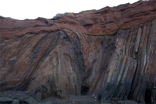
This small, complex area reveals that the older Eastern Block is unconformably overlain by Neoarchaean sediments, above which has been thrust a stacked series of nappes similar in size and form to those of the much younger Alpine orogenic belt of southern Europe. Though highly complex, the rocks involved having been folded and stretched by ductile processes, they are still recognisable as having originally been at the surface. Metavolcanics in the nappes can be assigned from their geochemistry to a late-Archaean fore-arc, through comparison with that of modern igneous rocks formed at such a setting in the Western Pacific. Thrust over the nappe complex is a jumble or mélange of highly deformed metasediments containing blocks of metabasalts and occasional ultramafic igneous rocks that geochemically resemble oceanic crust formed at a mid-ocean ridge. Some of them contain high-pressure minerals formed at depth in the mantle, indicating that they had once been subducted. The whole complex is cut by undeformed dykes of granitic composition dated at 2.5 Ga, confirming that the older rocks and the structures within them are Archaean in age. Thrust over the melange and tectonically underlying nappe complex are less-deformed volcanic rocks and granitic intrusions that closely resemble what is generally found in modern island arcs.

Orogenic belts bear witness to enormous crustal shortening caused by horizontal compressive forces. Assuming the average rate of modern subduction (2 cm yr-1) the 178 Ma history of the Zanhuan Complex implies more than 3,500 km of lateral transport. 2.5 billion years ago, higher radioactive heat production in the mantle would have made tectonic overturning considerably faster  The unconformity at the base of the complex suggests that it was driven over the equivalent of a modern passive, continental margin. So the complex provides direct evidence of horizontal plate tectonics and associated subduction during the latter stages of the Archaean that ranks in scale with that of many Phanerozoic orogenic belts, such as that of the European Alps. The Zanhuan Complex is a result of arc accretion that played a major role in many later orogens. The North China craton itself is reminiscent of continent-continent collision, as required in the formation of supercontinents.

What controls the height of mountains?

‘Everybody knows’ that mountains grow: the question is, ‘How?’ There is a tale that farmers once believed that they grew from pebbles: ‘every year I try to rid my field of stones, but more are back the following year, so they must grow’… Geoscientists know better – or so they think[!] – and for 130 years have referred to ‘orogeny’, a classically-inspired term (from the Ancient Greek óros and geneia – high-ground creation’) adopted by the US geologist Grove Gilbert. It incorporates the concept of crustal thickening that results from lateral forces and horizontal compression. Another term, now rarely used, is ‘epeirogeny’ (coined too by G.K. Gilbert), wherein the continental surface rises or falls in response to underlying gravitational forces. That could include: changing mantle density over a hot, rising plume; detachment or delamination into the mantle of dense lower lithosphere; loading or unloading by ice during glacial cycles. Epeirogeny is bound up with isostasy, the maintenance of gravitational balance of mass in the outermost Earth.

A small part of the High Himalaya (credit: Access-Himalaya)

In 1990, Peter Molnar and Philip England pointed out that the incision of deep valleys into mountain ranges results in stupendous and rapid removal of mass from orogenic belts, which adds a major isostatic force to mountain building (Molnar, P. & England, P. 1990. Late Cenozoic uplift of mountain ranges and global climate change: chicken or egg? Nature, v. 346, p. 29–34; DOI: 10.1038/346029a0). In their model, the remaining peaks are driven higher by isostasy. They, and others, coupled climate change with compressional tectonics in a positive feedback that drives peaks to elevations that they would otherwise never achieve. Molnar and England’s review saw complex interplays contributing to mountain building, accompanying chemical weathering even changing global climate by sequestering atmospheric CO2 into the minerals that it produces. As well as the height of peaks in active zones of crustal shortening and thickening, such as the Himalaya, Molnar and England’s theory explained the aberrant high peaks at the edge of high plateaus that are passively subject to erosion. Examples of the latter are the isolated peaks beyond the eastern edge of the Ethiopian Plateau that locally have the greatest elevation than the flood basalts that form the plateau: unloading around these peaks has caused them to rise isostatically.

Thirty years on, this paradigm is being questioned, at least as regards active orogens (Dielforder, A. et al. 2020. Megathrust shear force controls mountain height at convergent plate margins. Nature, v. 582, p. 225–229; DOI: 10.1038/s41586-020-2340-7). Armin Dielforder and colleagues at the German Research Centre for Geosciences in Potsdam and The University of Münster consider that overall mountain height is sustained by interactions between three forces. 1. They are prevented from falling apart under their own weight or being pushed up further against gravity by lateral tectonic force. 2. Climate controlled erosion limits mountain height by removing material from the highest elevations. 3. Isostasy keeps the mountains ‘afloat’ above the asthenosphere. The authors have attempted to assess and balance all three major forces that determine the overall elevation of mountain belts.

At a convergent plate margin where one plate is shoved beneath another, the megathrust above the subduction zone behaves in a brittle fashion, with associated friction, towards the surface. At depth this transitions to a zone of ductile deformation dominated by viscosity. A major assumption in this work is that stress in the crust below a mountain belt is neutral; i.e. horizontal, tectonic compression is equal to the weight of the mountains themselves and thus to their height. So, the greater the tectonic compressive force the higher the mountain range that it can support. The test is to compare the actual elevation with that predicted from plate-tectonic considerations. For 10 active orogenic belts there is a remarkable correspondence between the model and actuality. the authors conclude that variation over time of mountain height reflects log-term variations in the force balance, in which they find little sign of a climatic/erosional control. But that doesn’t resolve the issue satisfactorily, at least for me.

The study focuses on the mean elevation, and this leaves out the largest mountains; for instance, their maximum mean elevation for the Himalaya is about 5.46 km (in fact for a narrow  NE-SW swath that may not be representative of the whole range). Yet the Himalaya contains 10 of the world’s highest mountains, all over 8 km high and 50 peaks that top 7 km, adjacent to the Tibetan Plateau. The mean elevation of the whole Himalayan range is 6.1 km. Consequently, it seems to me, the range’s maximum mean elevation must be somewhat higher than that reported by Dielforder et al.  The difference suggests that non-tectonic forces do contribute significantly to Himalayan terrain

See also:  Wang, K. 2020. Mountain height may be controlled by tectonic force, rather than erosion. Nature, v. 582, p. 189-190; DOI: 10.1038/d41586-020-01601-4

Geochemistry and the Ediacaran animals

Hopefully, readers will be fairly familiar with the sudden appearance of the Ediacaran fauna – the earliest abundant, large animals – at the start of the eponymous Period of the Neoproterozoic around 635 Ma. If not, use the Search Earth-logs box in the side bar to find extensive coverage since the start of the 21st century. A June 2019 Earth-logs review of the general geochemical background to the Ediacaran Period can be found here. Ten years ago I covered the possible role of the element phosphorus (P) – the main topic here – in the appearance of metazoans (see: Phosphorus, Snowball Earth and origin of metazoans – November 2010).

One of the major changes in marine sedimentation seen during the Ediacaran was a rapid increase in the deposition on the ocean floor of large bodies of P-rich rock (phosphorite), on which a recent paper focuses (Laakso, T.A. et al. 2020. Ediacaran reorganization of the marine phosphorus cycle. Proceedings of the National Academy of Sciences, v. 117, p. 11961-11967; DOI: 10.1073/pnas.1916738117). It has been estimated that on million-year time scales phosphorites remove only a tiny amount of the phosphorus carried into the oceans by rivers. So, conversely, an increase in deposition of marine P-rich sediment would have little effect on the overall availability of this essential nutrient from the oceans. The Ediacaran boost in phosphorites suggests a connection between them and the arrival of totally new ecosystems: the global P-cycle must somehow have changed. This isn’t the only change in Neoproterozoic biogeochemistry. Thomas Laakso and colleagues note signs of slightly increased ocean oxygenation from changes in sediment trace-element concentrations, a major increase in shallow-water evaporites dominated by calcium sulfate (gypsum) and changes in the relative proportions of different isotopes of sulfur.

Because all marine cycles, both geochemical and those involving life, are interwoven, the authors suggest that changes in the fate of dead organic matter may have created the phosphorus paradox. Phosphorus is the fifth most abundant element in all organisms after carbon, hydrogen, nitrogen and oxygen, followed by sulfur (CHNOPS), P being a major nutrient that limits the sheer bulk of marine life. Perhaps changes to dead organic matter beneath the ocean floor released its phosphorus content, roughly in the manner that composting garden waste releases nutrients back to the soil. Two chemical mechanisms can do this in the deep ocean: a greater supply of sinking organic matter – essentially electron donors – and of oxidants that are electron acceptors. In ocean-floor sediments organic matter can be altered to release phosphorus bonded in organic molecules into pore water and then to the body of the oceans to rise in upwellings to the near surface where photosynthesis operates to create the base of the ecological food chain.

Caption The Gondwana supercontinent that accumulated during the Neoproterozoic to dominate the Earth at the time of the Ediacaran (credit: Fama Clamosa, at Wikimedia Commons)

There is little sign of much increase in deep-ocean oxygen until hundreds of million years after the Ediacaran. It is likely, therefore, that increased availability of oxidant sulfate ions (SO42-) in ocean water and their reduction to sulfides in deep sediment chemically reconstituted the accumulating dead organic matter to release P far more rapidly than before. This is supported by the increase in CaSO4 evaporites in the Ediacaran shallows. So, where did the sulfate come from? Compressional tectonics during the Neoproterozoic Era were at a maximum, particularly in Africa, South America, Australia and Antarctica, as drifting continental fragments derived from the break-up of the earlier Rodinia supercontinent began to collide. This culminated during the Ediacaran around 550 Ma ago with assembly of the Gondwana supercontinent. Huge tracts of it were new mountain belts whose rapid erosion and chemical weathering would have released plenty of sulfate from the breakdown of common sulfide minerals.

So the biological revolution and a more productive biosphere that are reflected in the Ediacaran fauna ultimately may have stemmed from inorganic tectonic changes on a global scale

Thin- or thick-skinned tectonics: a test

How the continental lithosphere deforms at convergent plate margins has been a matter of opinion that depends on where observations have been made in ancient orogenic belts. One view is that arc and collisional orogens are dominated by deformation of the upper crust and especially the cover of sedimentary and volcanic rocks above deeper and older basement. This is a ‘thin-skinned’ model in which rocks of the upper crust are detached from those below and thicken more or less independently by thrust faulting, the formation of ductile nappes or a combination of the two. Mountain ranges, in this view, are the product of piling up of thrust slices or nappes, as exemplified by the Alps, Canadian Rockies and the Caledonian thrust belt of NW Scotland. Thick-skinned processes, as the name suggests, see crustal shortening and thickening as being distributed through the crust from top to bottom and even involving the lithospheric mantle. The hinterlands of both the Alps and the Scottish Caledonides show plenty of evidence for entire-crust deformation, deep crustal rocks being found sheared together with deformed rocks of the cover. It stands to reason that orogenic processes on the grand scale must involve a bit of both.

Both hypotheses stem from field work in deeply eroded, structurally complex segments of the ancient crust, and it is rarely if ever possible to say whether both operated together or one followed the other during the often lengthy periods taken by orogeny to reach completion, and the sheer scale of the process. Orogenesis is going on today, to which major seismic activity obviously bears witness. But erosion has not progress from cover through basement so, up to now, only seismicity and geodetic GPS measurements have been available to show that continental crust in general is being shortened and thickened, as well as being moved about. Potentially, a means of assessing active deformation, even in the deep crust, is to see whether or not the speeds of seismic waves at different depths are biased depending on their direction of travel. Such anisotropy would develop if the mineral grains making up rocks were deformed and rotated to preferred directions; a feature typical of metamorphic rocks. But to make such measurements on the scale of active orogens requires a dense network of seismometers and software that can tease directionality and depth out of the earthquake motions detected by it.

LS-tectonite from the Paraiba do Sul Shear Zon...
Aligned minerals in a Brazilian metamorphic rock (credit: Eurico Zimbres in Wikipedia)

A joint Taiwanese-American consortium set up such a network in Taiwan, which is capable of this type of seismic tomography. Taiwan is currently taking up a strain rate of 8.2 cm per year due to motion of the Philippine Plate on whose western flank the island lies: it is part of an island arc currently colliding with the stationary Eurasian Plate and whose crust is shortening. Results of seismic anisotropy (Huang, T.-Y. et al. 2015. Layered deformation in the Taiwan orogen. Science, v. 349, p. 720-723) show that the fast direction of shear (S) waves changes abruptly at about 10 to 15 km deep in the crust. In the upper crust this lines up with the roughly N-S structural ‘grain’ of the orogen. At between 13 to 17 km down there is no discernible anisotropy, below which it changes to parallel the direction of plate motion, ESE-WNW. It seems that thin skinned tectonics is indeed taking place, although probably not above a structural detachment. Simultaneously the deep crust is being deformed but the shearing is ascribed to the descent of lithospheric mantle of the Philippine Plate beneath the Eurasian Plate, while the deep crust remains attached to the upper crust. If it were possible to examine the mineral lineations now forming in both the Taiwanese upper and lower crust where metamorphism is active, then the two directions would be apparent. Although not mentioned by the authors, perhaps the detection of different directionality of aligned metamorphic minerals in low- and high-grade metamorphic rocks might indicate such tectonic processes in the past.

January 2015 photo of the month

Angular unconformity on the coast of Portugal at Telheiro Beach (credit: Gabriela Bruno)
Angular unconformity at Telheiro Beach, Portugal (credit: Gabriela Bruno)

This image posted at Earth Science Picture of the Day would be hard to beat as the definitive angular unconformity. It shows Upper Carboniferous  marine metagreywackes folded during the Variscan orogeny overlain by Triassic redbeds. Structurally it is uncannily similar to Hutton‘s famous unconformity at Siccar Point on the coast of SE Scotland, although the tight folding there is Caledonian in age and the unconformable redbeds are Devonian in age.