Followers can now download newly posted annual logs for Human Evolution and Migrations covering the years 2022 to 2025. By downloading them you can get a clear idea of how palaeoanthropology has moved forward since the Covid pandemic.
Enjoy the experience if you have the time and inclination!
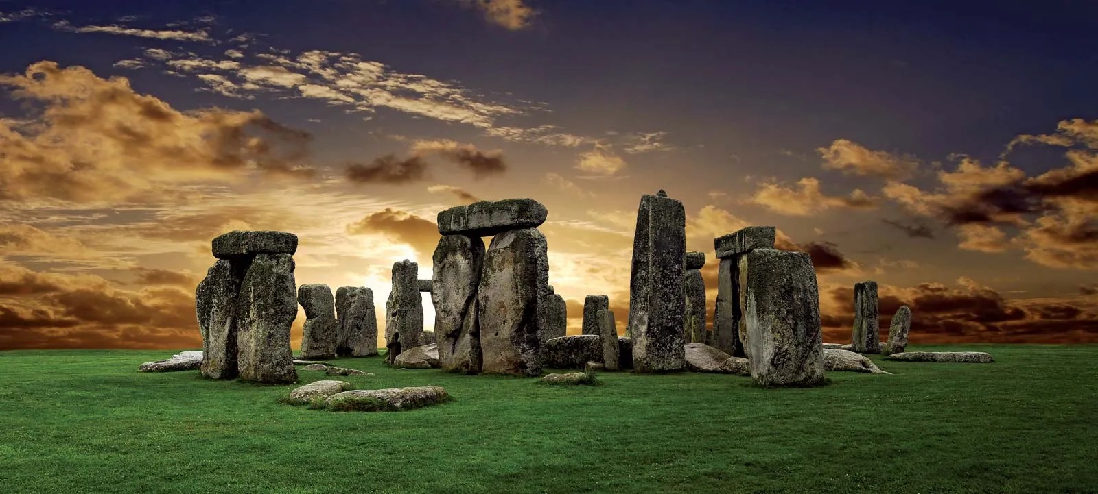
The great megalithic structure is the centrepiece of a vast ritual landscape on a 780 km2 plateau known as Salisbury Plain, underpinned by Cretaceous limestone: the largest remaining area of calcareous grassland in northwest Europe. The earliest sign that the Plain was used for ritual purposes dates to ten thousand years ago (8,000 BCE), when Mesolithic hunter gatherers erected large wooden posts to define by an E-W line the Sun’s rise and setting at the equinoxes. The area seems to have been continuously populated until 4,000 BCE when the first Neolithic farmers settled the Plain and began building burial mounds (barrows) to celebrate notable individuals and families.
The Stonehenge monument began as a circular cemetery around 3,100 BCE. Its development to the astonishing structure that remains largely intact today occupied the Neolithic populace and succeeding Bronze Age immigrants for the next 1,600 years. This involved setting up and then repeatedly shuffling around several kinds of boulders or megaliths. The first, around 2,600 BCE, were 2 to 3 tonne blocks mainly of igneous rock (the ‘bluestones’), now known to have originated from outcrops of Ordovician volcanics in Pembrokeshire about 230 km to the west. Next to arrive was a 6 tonne grey-green sandstone slab, now lying flat (hence its being named the ‘Altar’ Stone) beneath a fallen, far bigger megalith,. Once thought to be of Welsh provenance – in the Brecon Beacons 150 km to the west – the Altar Stone is now beyond a shadow of doubt to have come from Devonian strata in northern Scotland, possibly Orkney. The final erection of 30 truly enormous ‘sarsens’ to create Stonehenge’s signature circle and inner ‘horseshoe’ of vertical slabs capped by lintels took place between 2,600 to2 400 BCE. Weighing up to 50 tonnes, the sarsens are locally derived from remnants of Lower Eocene (~55 Ma) sands cemented by chemically precipitated silica (SiO2) that once covered much of southern England.
After 1,600 BCE, serious fiddling with the various stones, the bluestones in particular, ceased. The monument may have remained in some form of use during the Iron Age: it could hardly have been ignored. The first record of antiquarian interest is from the late 17th century and continued sporadically until systematic excavation of archaeological features on the Plain got underway during the 19th century and continues to the present.
Much recent literature has concentrated on what Stonehenge was for and how it was built, leading to a rich eclecticism and a little experimentation. But given the size of its stones and the obviously exotic nature of some of them, there have been disputes between those who consider them to have been brought by natural means and those who suggest collective human endeavour. The latter would have involved vast amounts of labour, shifting the bluestones over 250 km, entire community muscle power to drag the locally occurring sarsens about 25 km from their probable source, and a journey of at least 700 km to get the Altar Stone in place. Since none of the stones could conceivably have been moved by river flow, the only natural alternative for their transport is by glacial action.
Such an ice-transport theory rests on at least one of the several known advances of Pleistocene ice sheets having reached as far south as Salisbury Plain and deposited upon it glacial till that contains material from NE Scotland and South Wales. The most obvious indicators of glacial transport are large erratic boulders strewn far from their source down a previous ice stream that their distribution helps to reconstruct. In Northern Britain a great many megaliths that people erected long ago are glacial erratics of one kind or another. Of course, glacial tills contain grains of all sizes ripped and ground from the course of glacial flow. No so obvious, but equally capable of revealing transportation paths. After ice sheets melt, the till that they dump is eroded so that exotic rock and mineral grains enter drainage systems, some to remain in stream sediments. Two geologists based at Curtin University in Perth, Western Australia collected river sands from four active drainage systems on Salisbury Plain to test the glacial-transport hypothesis for the Stonehenge megaliths (Clarke, A.J.I. & Kirkland, C.L. 2026. Detrital zircon–apatite fingerprinting challenges glacial transport of Stonehenge’s megaliths. Communications Earth & Environment, v. 7, article 54; DOI: 10.1038/s43247-025-03105-3).
Using standard mineral-separation techniques – removal of low-density minerals (mainly quartz and feldspar) and those that are magnetic – Anthony Clarke and Christopher Kirkland mounted and polished samples of the remaining high-density grains embedded in resin. Using automated X-ray spectroscopy they identified grains of two minerals, zircon and apatite, that can be dated using uranium and lead isotopes. Zircons are virtually absent from the underlying Chalk although phosphorus-rich horizons in that rock sometimes contain apatite, a complex calcium phosphate. Both minerals are commonly found in igneous and metamorphic rocks and, being chemically resistant and hard, are often present in sediments derived by erosion of such parent rocks. The authors analysed U-Pb isotopes using laser ablation plasma mass spectrometry of suitable grains of each mineral. The U-Pb data from 250 apatite grains revealed a dominant age peak at 60 Ma, roughly the base of the once overlying Palaeogene sediments. Far fewer grains hint at older ages (175, 215, 300 and 625 Ma) in the Mesozoic, Palaeozoic and Neoproterozoic. The 550 analysed zircons span an age range from the Silurian to Palaeoproterozoic (432 to 1870 Ma), with a few outliers as young as 285 Ma and as old as 3396 Ma.
These data seem to suggest that they can support virtually any glacial transport hypothesis, including that of the Altar Stone, let alone the Stonehenge bluestones. However, that would be to misunderstand the complexity of sediment transport in relation to their original provenance. Erosion from a bedrock source leads to transport and deposition in sedimentary rock. Later uplift and erosion of that secondary host rock is followed by later sediment transport to another rock repository and so on and so forth through the entire geological history of Britain, across its jumble of many tectonic terranes and the effects of numerous orogenic episodes! The Salisbury Plain chalk lands were covered by Palaeogene sedimentary rocks of the London Basin. And, lo and behold, one of those younger sediments, the Thanet Formation sandstones, tell much the same U-Pb story as do the modern river sediments of Salisbury! Those Palaeocene sands elsewhere directly overlie the Chalk and, in some localities on Salisbury Plain, still do today in the form of the chemically cemented sarsens. About 50 Ma ago (early Eocene) the Palaeocene rocks and those beneath were broadly buckled by the outermost ripples of the Alpine orogeny. Once eroded from above the Plain they would certainly have delivered that signature to the mercy of subsequent back and forth river transport. And indeed the sarsens, hard to miss in that landscape, perhaps still do so. Yet no one has thought to examine their content of heavy-mineral grains.
It does seem to me that the authors, perhaps inadvertently, walked into a sedimentological minefield in a vain attempt to put the lid on the fractious debate about human- versus glacial-transport of the Stonehenge megaliths. It is not their data that fling down a ‘challenge’ to the latter hypothesis (see their Conclusions), but the widely accepted absence of even the tiniest nugget of bluestone or Devonian sandstone on the vast and heavily excavated ritual landscape of Salisbury Plain, or indeed in the gravels of the streams that currently drain the Plain. But this where the plot thickens. A recent paper by one of the proponents of the glacial hypothesis (John, B.S. 2024. A bluestone boulder at Stonehenge: implications for the glacial transport theory. E&G Quaternary Science Journal v. 73, p. 117-134;DOI: 10.5194/egqsj-73-117-2024) describes a small piece of bluestone (22 × 15 × 10 cm) that was found during excavations at Stonehenge in 1924 and mysteriously ‘rescued’ by a Robert Newall and stored in his attic for almost 50 years, eventually examined by geologists and then returned to the attic. In 1976, two years before his death Newall passed it to the curator of Salisbury Museum ‘for safe keeping’. Brian John claims that its shape and surface texture suggests glacial transport. It also has several percussion scars suggesting that it had been worked, perhaps by someone hoping to make a stone tool. Unsurprisingly, Johns succeeded in provoking a storm of criticism from archaeologists largely of the human-transport wing of the controversy. And then there is the Mumbles Erratic, found at the eponymous Mumbles headland to the west of Swansea Bay. It too looks like a ‘bluestone’, but is it an erratic or from a Neolithic ship wreck carrying bluestones from Pembrokeshire?
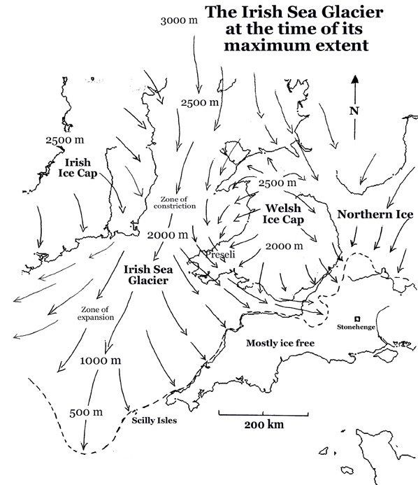
Maximum extent of glaciation in SW Britain during the Anglian Stage 478 to 424 ka ago (Credit: Wikipedia Commons)
A great deal of work by British glaciologists has established the flow patterns and extent of major ice sheets, but only for four onshore, even though there is offshore evidence for repeated glaciation back as far as 2.5 Ma ago. The most extensive of these was the Anglian Stage between 478 and 424 ka ago. The figure above shows that the Irish Sea Glacier did not reach the Stonehenge area, but it did cross Pembrokeshire to reach Somerset on the eastern side of the Bristol Channel. Bluestone erratics may have been much more easily available than blocks hewn at their source in SW Wales, an hypothesis that is currently in vogue. Nope, the quest is not over …
The origin of animals occurred sometime during the Proterozoic Eon, perhaps as early as 2.1 Ga (billion years ago) after the Great Oxygenation Event. Available oxygen is a prerequisite for animal life, and that is about as far back as palaeobiologists can push it. More familiar are the trace fossils known as the Ediacaran fauna which emerged after the environmentally highly stressful Cryogenian Period that was marked by two Snowball Earth events. Traces of these animals may have been big enough to be easily found, but they were not particularly diverse and are difficult to place in any particular modern group. Most modern animals have front- and rear ends, tops and bottoms, and input and output orifices. The earliest of these bilaterian beasts may have emerged during the Ediacaran as well, but were not very prepossessing. It was during the Cambrian Period (541 to 485 Ma) that most modern animal phyla became recognisable to palaeobiologists. That carnival of diversification is widely known as the Cambrian Explosion. Yet it was later in geological time that the full panoply of Phanerozoic diversity among taxa below the level of the phylum truly exploded, punctuated by mass extinctions and the diversification that followed each of them. So, what lay behind the initial emergence of the characteristics that form the basic templates of the phyla themselves?
Cartoon of the Cambrian Explosion in benthic faunas. Credit: Gabriela Mangano and Luis A. Buatois, 2016 The Cambrian Explosion, Fig 3.15
A multinational team of modellers and geoscientists have moved the focus from long-term shifts in climate and atmospheric chemistry to what might change from day to night in an ecosystem during the diel cycle (Hammarlund, E.U. and 13 others 2025. Benthic diel oxygen variability and stress as potential drivers for animal diversification in the Neoproterozoic-Palaeozoic Nature Communications, v. 16, article 2223; DOI:10.1038/s41467-025-57345-0). During the Neoproterozoic oxygen levels in Earth atmosphere rose to about half the amount present today. But animals arose and evolved in sea water. The most prolific source of food for them would have been in shallow water (the benthic zone), simply because sunlight in the photic zone encourages photosynthesis. As well as a thriving base for animal life’s food chain shallow water is where oxygen is produced; but only during daylight hours. At night decay of organic matter on the seabed draws down dissolved oxygen. Emma Hammarlund and colleagues wondered if day-night changes in oxygen levels might have exerted sufficient stress to force early animals to adapt and thus diversify. Their model shows that in warm, shallow water the lower oxygen levels at the start of the Phanerozoic could change dramatically in the diel cycle. Algae at the base of the food chain would swiftly oxygenate the water in daylight, but at night would consume it to produce much lower levels. Animals that were better adapted to the stress of this daily ‘feast-and-famine’ cycle in oxygen availability would outcompete others that were less resilient for the available nutrients. Environmental stress had flipped from an obstacle to evolution to a catalyst for it. The earliest appearances of organisms in the 10 modern phyla seem to coincide with global warming at low latitudes to an air temperature of about 25° C at the start of the Cambrian, perhaps when this shift began.
Another empirical coincidence lies in the sedimentary rock record. On modern continents the base of Phanerozoic sediments is widely marked by shallow-water sandstones often at an unconformity. Often white and containing abundant burrows, the sandstones are signs of abundant life, though rarely contain body fossils. They represent global sea-level rise that flooded the existing continents, so the highly productive benthic environment became about four times more widespread at the end of the Cambrian than it was during the previous Ediacaran Period. Abundant life forms were under stress more or less everywhere. Thereafter these ‘shelf seas’ halved in total area, but the basic ‘templates’ for animal life were well-established and the numbers of classes, orders, families etcetera steadily burgeoned. By the end of the Cambrian oxygen production rose so that atmospheric concentration of the gas reached 25%, higher then it is at present.
Anyone who read the manifestos of the mainstream political parties in the UK – there may not be many who did – would have been amused to see that all promised to resolve the plague of potholes in the countries roads, both major and minor. For decades road users have been alarmed when hitting a pothole and in some cases had damage inflicted on their vehicles, and in the case of those on two wheels, on themselves. The RAC (Royal Automobile Club) has estimated that there are, on average, six potholes per mile on Britain’s roads: the greatest density in Europe. The AA (Automobile Association) estimated that almost £0.6 billion was spent in 2024 repairing pothole-damaged vehicles. This is not a new phenomenon. Before the advent of turnpike trusts in the late 18th century, which maintained roads travelled by Britain’s mail coach services, it was not uncommon to encounter potholes up to two metres deep. Legend has it that on one such route through northern Nottinghamshire two coach horses fell into a pothole and drowned. Scottish engineer, John Loudon McAdam invented a solution around 1820: crushed stone laid on the road surface in slightly convex layers, the topmost being bonded with stone dust. This ‘macadam’ surface created cambered highways that drained rainwater to the sides and downwards. Modern roads are still based on that principle, with the addition of tar or bitumen to the top layer to produce a hard, impermeable surface, which also prevents aggregate and dust being sucked from the surface by fast moving vehicles.
A spore of the club moss Lycopodium
So, why the potholes? Several reasons: increased traffic; heavier vehicles; less maintenance; patching rather than resurfacing. Most important: the materials and the weather. Dry, hot weather softens the bitumen and drives out volatile hydrocarbons making the bitumen less plastic. The pounding of tyres in cooler weather fractures the now stiffened bitumen, mainly at microscopic scales. Wetting of the tarmac seeps water into the microfractures. The formation of ice films jacks opens the microfractures and produces more in the cold stiff bitumen, eventually to separate the particles of aggregate in the asphalt. The wearing course begins to crumble so that aggregate grains escape and scatter. Thus weakened, the top layer breaks up into larger fragments and a pit forms to join up with others so that a pothole forms and grows. Wheels of traffic bounce when they cross a pothole, the shock of which causes the centre of degradation to shift and create more cavities. Simply filling the existing potholes merely serves to create new ones: a vicious cycle that can only be broken by complete resurfacing: the traffic cones come out!.
All this has been known for well over a century by civil engineers. Around the start of the 21st century – maybe slightly earlier – it dawned on engineers that the critical problem was degradation of bitumen. A petroleum derivative, occurring naturally as surface seeps in some oilfields, bitumen is chemically complex: a combination of asphaltenes and maltenes (resins and oils). Deterioration of bitumen through evaporation, oxidation and exposure to ultraviolet radiation decreases the maltene content and stiffens the binding agent in asphalt. So the earliest attempts at reducing pothole formation centred on rejuvenation by periodically adding substitutes for maltenes to road surfaces. Diesel (gas-oil) works, but is obviously hazardous. More suitable are vegetable oils such as waste cooking oils or those produced by pyrolysis of cotton, straw, wood waste and even animal manure. The problem is getting the rejuvenators into existing asphalt surfaces: clearly, simply spraying them on the surface seems a recipe for disaster! A solution that dawned on engineers around 2005 was to make bitumen that is ‘self-healing’.
Schematic of the production of microcapsules from club moss spores to contain sunflower oil to be used in self-healing asphalt (Credit: Alpizar-Reyes, E. et al. 2022)
Simply mixing rejuvenators into bitumen during asphalt manufacture will not do the trick, for the result would be a weakened binding agent at the outset. For the last 15 years researchers have sought means of adding rejuvenators in porous capsules, to release them as microfractures begin to form: on demand, as it were. There have been dozens of publications about experiments that found ‘sticking points’. However, in early 2025 what seems to be a viable breakthrough splashed in the British press. It was made by an interdisciplinary team of scientists from King’s College London and Swansea University, in collaboration with scientists in Chile. They chemically treated spores of Lycopodiumclub mosses to perforate their cell walls and clear out their contents to be replaced by sunflower oil, an effective bitumen rejuvenator. Experiments showed that such microcapsules released the oil to heal cracks in aged bitumen samples in around an hour. Mixed into bitumen to be added to asphalt they would remain ‘dormant’ until a microfracture formed in their vicinity released it, thereby making the asphalt binder self healing.
Will such an advance finally resolve the pothole plague? It may take a while …
You will have noticed a 5-week break in my posting news items, for which I need to apologise and to explain.
Despite weekly searching all the leading journals that publish geoscientific papers, none have appeared that meet my criteria for commenting. That is, nothing has emerged that makes a significant breakthrough in any of the the Categories that Earth-logs covers. In fact, since Covid I have noticed a drop in the number of publications that do. Maybe there was a downturn in research during the pandemic, or perhaps some other reason such as a decline in the discipline, of journal policy changes.
There’s not much I can do other than wait patiently, and post when something turns up – you will be among the first to know about it, as ever!
In the meantime, maybe one or more of you have come across something interesting that I missed, or have a question about topics covered earlier. Either way, don’t hesitate to get in touch with me, either with a comment or using the Contact Author link in the Menu bar.
Climate during the last Ice Age was continually erratic. Generally fine-grained muds cored from the floor of the North Atlantic Ocean show repeated occurrences of layers containing gravelly debris. These have been ascribed to periods when ice sheets on Greenland and Scandinavia calved icebergs at an exceptionally fast rate, to release coarse debris as they melted while drifting to lower latitudes. These ‘iceberg armadas’ (known as Heinrich events) left their unmistakable signs as far south as Portugal. Their timing correlates with short-lived (1 to 2 ka) warming-cooling episodes (Dansgaard-Oeschger events) recorded in Greenland ice cores that involved variations in air temperature of up to 15°C. The process that resulted in these sudden climate shifts seems to have been changing ocean circulation brought about by vast amounts of fresh water flooding into the Arctic and North Atlantic Oceans. This lowered seawater density to the extent that its upper parts could not sink when cooled. It is this thermohaline circulation that drags warmer surface water northwards, known as the Atlantic Meridional Overturning Circulation (AMOC), part of which is the Gulf Stream. When it fails or slows the result is plummeting temperatures at high latitudes. The last major AMOC shutdown was after 8 ka of warming that followed the last glacial maximum. Between 12.9 and 11.7 ka major glaciers grew again north of about 50°N in the period known as the Younger Dryas, almost certainly in the aftermath of a flood to the Arctic Ocean of glacial meltwater from the Canadian Shield. Around 8.2 thousand years ago human re-colonisation of Northern Europe was set back by a similar but lesser cooling event.
The Atlantic Meridional Overturning Circulation (AMOC). Red – warm surface currents; cyan – cold deep-water flow. (Credit: Stefano Crivellari)
Three researchers at Utrecht University, the Netherlands have issued an early warning that the AMOC may have reached a critical condition (Van Westen, R.M., Kliphuis, M & Dijkstra, H.A. 2024. Physics-based early warning signal shows that AMOC is on tipping course. Science Advances, v. 10, article adl1189; DOI: 10.1126/sciadv.adk1189). Previous modelling of AMOC has suggested that only rapid, massive decreases in the salinity of North Atlantic surface water near the Arctic Circle could shut down the Gulf Stream in the manner of Younger Dryas and Dansgaard-Oeschger events. René van Westen and colleagues have simulated the effects of steady, long-term addition of fresh water from melting of the Greenland ice sheet. They ran a sophisticated Earth System model for six months on the Netherlands’ Snellius super computer. Their model used a slowly increasing influx of glacial meltwater to the Atlantic at high northern latitudes.
The various feedbacks in the model eventually shut down the AMOC, predicted to result in cooling of NW Europe by 10 to 15 °C in a matter of a few decades. Yet to achieve that required the model to simulate more than 2000 years of change. It took 1760 years for a persistent AMOC transport of 10 to 15 million m3 s-1 to drop over a century or so and reach near-zero. That collapse involved around 80 times more melting of Greenland’s ice sheet than at present. Yet their modelling does not take into account global warming: including that factor would have exceeded their budgeted supercomputer time by a long way. Melting of the Greenland ice sheet is, however, accelerating dramatically
Van Westen et al. have shown the possibility that steadily increasing ice-sheet melting can, theoretically, ’flip’ the huge current system associated with the Atlantic Ocean, and with it regional climate patterns. The tangible fear today is of a more than 1.5°C increase in global surface temperature, yet a warming-induced failure of AMOC may cause local annual temperatures to fall by up to ten times that. Rather than the currently heralded disappearance of sea-ice from the Arctic Ocean, it may spread in winter to as far south as the North Sea. The only way of forecasting in detail what may actually happen – and where – is ever-more sophisticated and costly modelling of ocean currents and ice melting in a warming world. Uncertain as it stands, the work by van Westen and colleagues may well be ignored: perhaps as a ‘thing we dinnae care to speak aboot’.
Good illustrations of self publicity and soaring ambition are the private space programmes of oligarchs Elon Musk (SpaceX), Jeff Bezos (Blue Origin) and Richard Branson (Virgin Galactic). For a cool US$65 million a ‘civilian’ can get a trip to the International Space Station on SpaceX; a one-hour suborbital flight on Blue Origin will cost US$300,000, with luck having Bezos as a companion; a reservation on Virgin Galactic for a 1 hour trip to the ‘edge of space’ (~100 km up) now costs US$624,000. It’s a tourist trip for the very, very rich only … but even the long-dead can go … or bits of them. On 8 September 2023 aboard Virgin Galactic flight Tim Nash, a South African billionaire had in his pocket a sturdy tube containing a thumb bone of Homo nalediand the collarbone of Australopithecus sediba. Nash reportedly said afterwards, “I am humbled and honoured to represent South Africa and all of humankind as I carry these precious representations of our collective ancestors”.
Reconstructed head of a somewhat annoyed Homo naledi. Credit: John Gurche, Mark Thiessen, National Geographic.
Nash was entrusted with these unique fossils by Lee Berger, Professor in Palaeoanthropology at Witwatersrand University, South Africa and a National Geographic Explorer-in-Residence. Berger recovered fossils of both species from limestone caves in the UNESCO World Heritage Site grandly named the Cradle of Humankind near Johannesburg. He is no stranger to controversy, and this venture cooked up with Nash seems to aim at promotion of South African achievements rather than having any scientific purpose. It has backfired spectacularly (see: McKie, R. 2023. ‘Callous, reckless, unethical’: scientists in row over rare fossils flown into space. The Observer, 22 October 2023). Comments from the anthropological world, six national and international bodies and perhaps the leading hominin specialist Professor Chris Stringer of the Natural History Museum in London include the words and phrases “callous”, “unethical”, “extraordinarily poorly thought-out”, “a publicity stunt”, “reckless” and “utterly irresponsible”. The caper breaks the South African, indeed international, scientific rule that fossils can only be allowed to travel for scientific purposes, applied consistently by similarly hominin-rich African countries such as Ethiopia, Kenya and Tanzania.
But, Hey, that’s how you get on in the world … isn’t it?
Along with algae, jellyfish, oak trees, sharks and nearly every organism that can be seen with the naked eye, we are eukaryotes. The cells of every member of the Eukarya, one of the three great domains of life, all contain a nucleus – the main location of genetic material – and a variety of other small bodies known as organelles, such as the mitochondria of animals and the chloroplasts of plant cells. The vast bulk of organisms that we can’t see unaided are prokaryotes, divided into the domains of Bacteria and Archaea. Their genetic material floats around in their cells’ fluid. The DNA of eukaryotes shares some stretches with prokaryotes, but no prokaryotes contain any eukaryote genetic material. This suggests that the Eukarya arose after the Bacteria and Archaea, and also that they are a product of evolution from prokaryotes, probably by several combining in symbiotic relationships inside a shared cell membrane. Earth-logs has followed developments surrounding this major issue since 2002, as reflected in some of the posts linked to what follows.
While prokaryotes can live in every conceivable environment at the Earth’s surface and even in a few kilometres of crust beneath, the vast majority of eukaryotes depend on free oxygen for their metabolism. Logically, the earliest of the Eukarya could only have emerged when oxygen began to appear in the oceans following the Great Oxidation Event around 2.4 billion years ago. That is more than a billion years after the first prokaryotes had left their geological signature in the form of curiously bulbous, layered carbonate structures (stromatolites), probably formed by bacterial mats. The oldest occur in the Archaean rocks of Western Australia as far back as 3.5 Ga, and disputed examples have been found in the 3.7 Ga Isua sediments of West Greenland. The oldest of them are thought to have been produced through the anoxygenic photosynthesis of purple bacteria (See: Molecular ‘fossils’ and the emergence of photosynthesis; September 2000), suggested by organic molecules found in kerogen from early Archaean sediments. Later stromatolites (<3.0 Ga) have provided similar evidence for oxygen-producing cyanobacteria.
Acritarchs are microfossils of single-celled organisms made of kerogen that have been found in sediments up to 1.8 billion years old. Features protruding from their cell walls distinguish them from prokaryote cells, which are more or less ‘smooth’: acritarchs have been considered as possible early eukaryotes. Yet the oldest undisputed eukaryote microfossils – red and green algae – are much younger (about 1.0 Ga). A means of estimating an age for the crown group from which every later eukaryote organism evolved – last eukaryotic common ancestor (LECA) – is to use an assumed rate of mutation in DNA to deduce the time when differences in genetics between living eukaryotes began to diverge: i.e. a ‘molecular clock’. This gives a time around 2 Ga ago, but the method is fraught with uncertainties, not the least being the high possibility of mutation rates changing through time. So, when the Eukarya arose is blurred within the so-called ‘boring billion’ of the early Proterozoic Eon. A way of resolving this uncertainty to some extent is to look for ‘biomarker’ chemicals in the geological record that provide a ‘signature’ for eukaryotes.
A new study has been undertaken by a group of Australian, German and French scientists to analyse sediments ranging in age from 635 to 1640 Ma from Australia, China, Asia, Africa, North and South America (Brocks, J.J and 9 others 2023. Lost world of complex life and the late rise of the eukaryotic crown. Nature, v. 618, p. 767–773; DOI: 10.1038/s41586-023-06170-w; contact for PDF). Their chosen biomarkers are sterols (steroids) that regulate eukaryote cell membranes. Some prokaryotes also synthesise steroids but all of them produce hopanepolyols (hopanoids), which eukaryotes do not. The key measures for the presence/absence of eukaryote remains in ancient sea-floor sediments is thus the relative proportions of preserved steroids and hopanoids, together with those for the breakdown products of both – steranes and hopanesthat are, crudely speaking, carbon ‘skeletons’ of the original chemicals.
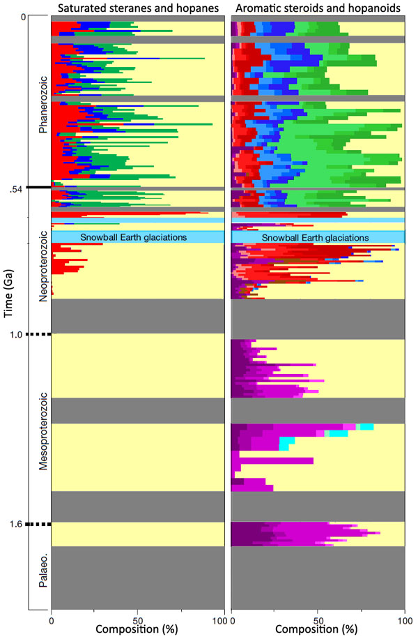
Proportions of biomarkers in sediments from present to 1.64 Ga. Cholesteroids – reds; ergosteroids – blues; stigmasteroids – greens; protosteroids magentas, hopanoids – yellows; unsampled – grey. Snowball glaciations are shown in pale blue. (Credit: Simplified from Figure 3 in Brocks et al.)
Interpretation of the results by Jochen Brocks and colleagues is complicated, and what follows is a summary based partly on an accompanying Nature News & Views article(Kenig, F. 2023. The long infancy of sterol biosynthesis. Nature, v. 618, p. 678-680; DOI: 10.1038/d41586-023-01816-1). The conclusions of Brocks et al. are surprising. First, the break-down products of steroids (saturated steranes) that can be attributed to crown eukaryotes (left on the figure above) are only present in sediments going back to about 200 Ma before the first Snowball Earth event (~900 Ma). Before that only hopanes formed by hopanoid degradation are present: a suggestion that LECA only appeared around that time – the authors suggest sometime between 1 and 1.2 Ga. That is far later than the time when eukaryotes could have emerged: i.e. once there was available oxygen after the Great Oxidation Event (~2.4 to 2.2 Ga). So what was going on before this? The authors broke new ground in analysis of biomarkers by being able to detect signs of the presence of actual hopanoids and steroids of several different kinds. Steroids were present as far back as 1.6 Ga in the oldest sediments that were analysed.
Steroids of crown eukaryotes are represented by cholesteroids, ergosteroids and stigmasteroids. All three are present throughout the Phanerozoic Eon and into the time of the Ediacaran Fauna that began 630 Ma ago. In that time span they generally outweigh hopanoids, thus reflecting the dominance of eukaryotes over prokaryotes. Back to about 900 Ma, only cholesteroids are present, together with archaic forms that are not found in living Eukarya, termed protosteroids. Before that, only protosteroids are found. Moreover, these archaic steroids are not present in sediments that follow the Snowball Earth episodes (the Cryogenian Period).
Thus, it is possible that crown group eukaryotes – and their descendants, including us – evolved from and completely replaced an earlier primitive form (acritarchs?) at around the time of the greatest climatic changes that the Earth had experienced in the previous billion years or more. Moreover, the Cryogenian and Ediacaran Periods seem to show a rapid emergence of stigmasteroid- and ergosteroid production relative to cholesteroid: perhaps a result of explosive evolution of the Eukarya at that time. The organisms that produced protosteroids were present in variable amounts throughout the Mesoproteroic. Clearly there need to be similar analyses of sediments going back to the Great Oxygenation Event and the preceding Archaean to see if the protosteroid producers arose along with increasing levels of molecular oxygen. The ‘boring billion’ (2.0 to 1.0 Ga) may well be more interesting than previously thought.
For ease of access to annual developments within the general topics that Earth-logs covers I have now compiled all the Earth-logs posts from 2020 and 2021 into the categories: Geohazards; Geomorphology; Human Evolution; Magmatism; Palaeobiology; Palaeoclimatology; Physical Resources; Planetary Science; Remote Sensing; Sediments and Stratigraphy, and Tectonics. You can download them by ‘hovering’ over the Annual logs pull-down in the main menu and clicking on a category, whose index page will appear. Then scroll down to the 2020 or 2021 entry and click on the link to the PDF.
I hope that readers find this option useful in showing how each general topic has developed over the 21st century so far. Of course, it is based on my personal view of what constitute important developments published in international journals
Two decades ago the world of palaeoanthropologists was in turmoil with the publication of an account of a new find in Chad (see: Bonanza time for Bonzo; July 2002). A fossil cranium, dubbed Sahelanthropus tchadensis (nicknamed Toumaï or ‘hope of life’ in the Goran language), appeared like a cross between a chimpanzee and an australopithecine. The turmoil erupted partly because of its age: Upper Miocene, around 7 Ma old. Such an antiquity was difficult to reconcile with the then accepted ~5 Ma estimate for the evolutionary split between humans and chimpanzees, based on applying a ‘molecular clock’ approach to the difference between their mtDNA. The other point of contention was the size of Sahelanthropus’s canine teeth: far too large for australopithecines and humans, but more appropriate for a gorilla or chimp.
Cast of the reconstructed skull of Sahelanthropus tchadensis. (Credit: Didier Descouens, University of Toulouse)
In the absence of pelvic- and foot bones, or signs of the foramen magnum where the spinal cord enters the skull – crucial in distinguishing habitual bipedalism or being an obligate quadruped – encouraged the finders of a 6.1 to 5.7 Ma-old Kenyan hominin Orrorin tugenensis to insist that its skeletal remains – several teeth, fragments of a lower jaw, a thigh bone, an upper arm and of a finger and thumb but no cranial bones – were of ‘the earliest human ancestor’. In Orrorin’s favour were smaller canine teeth than those of later australopithecines. At the time of the dispute, centred mainly on absence of crucial evidence, doyen of hominin fossils Bernard Wood of George Washington University and an advocate of ‘untidy’ evolution, suggested that both early species may well have been evolutionary ‘dead ends’ (see: A considered view; October 2002). And there the ‘muddle’ has rested for 20 years.
In 2002 not only a cranium of Sahelanthropus had been unearthed. Three lower jaw bones and a collection of teeth suggested that as many as 5 individuals had been fossilised. A partial leg bone (femur) and three from forearms (ulna) cannot definitely be ascribed to Sahelanthropus but, in the absence of evidence of any other putative hominin species, they may well be. It has taken two decades for these remains to be analysed to a standard acceptable to peer review (Daver, G. et al. 2022. Postcranial evidence of late Miocene hominin bipedalism in Chad. Nature v. 608, published online; DOI: 10.1038/s41586-022-04901-z). The authors present convoluted anatomical evidence that Toumaï’s femur, which had been gnawed by a porcupine and lacks joints at both ends, suggesting that it was indeed suited to upright walking. Yet the arm bones hint that it may have been equally comfortable in tree canopies. Yet it does look very like an ape rather than a hominin.
Much the same conclusion has been applied to Australopithecus afarensis, indeed its celebrated representative ‘Lucy’ met her end through falling out of a large tree ~3.2 Ma ago (see: Lucy: the australopithecine who fell to Earth?; September 2016). So, dual habitats may have been adopted by hominins long after they emerged. Yet Au afarensis was capable of trudging through mud as witnessed by the famous footprints at Laetoli in Tanzania. Only around 3 Ma has reasonably convincing evidence for upright walking similar to ours been discovered in Au africanus. The full package of signs from pelvis and foot for habitual bipedalism dates to 2 Ma ago in Au sediba. Even this latest known australopithecine seems to have had a gait oddly different from that of members of the genus Homo.
So, in many respects the benefits of full freeing of the hands to develop manipulation of objects, as first suggested by Freidrich Engels, may have had to await the appearance of early humans. Earlier hominins almost certainly did make tools of a kind, but the revolutionary breakthrough associated with humanity was more than 5 million years in the making.
Charles Darwin’s ideas on the evolution of species through natural selection became imprinted by his participation in the second survey expedition of HMS Beagle (1831-1836), commanded by Captain Robert Fitzroy. The voyage aimed at comprehensive surveys along its circumnavigation, Darwin having been engaged to provide geological expertise. At that time he would have been best described as a ‘natural historian’ and his only qualification was that he had an ordinary degree (BA) from Cambridge and had read widely in natural science: had it not been for joining the Beagle he may have become a country parson.
The voyage was a maritime venture typical of British and other European imperialism and colonisation during the early 19th century – a survey not only of geodesy, geography and natural science but also of the economic potential of the places that it visited. European science benefitted immensely from such voyages and overland expeditions. Today, research in the natural sciences is still dominated by academics from the better-off nations. Significantly, the charting of the ocean floor during the 20th and 21st centuries has been conducted almost exclusively by those nations with a global reach: plate tectonics is a science for the very wealthy. It is only in the last 60 years that geological mapping of the bulk of the continental surface has been relinquished by former colonial powers to local surveys. In the majority of cases the geological surveys of these now independent countries are grossly underfunded and they still largely depend on maps produced more than half a century ago by their former rulers.
In the 19th century global palaeontology, botany and zoology, which lie at the roots of evolutionary studies, shipped specimens to the museums and universities of the colonising powers. Their scientists today still retain a near monopoly of access to those old collections. Now it is economic power that enables continued collection by researchers mainly from the former colonising countries and their institutions. There are a few exceptions, such as the rapid rise of Chinese natural science in a mere three to four decades, which has become a major ‘player’ in early and Mesozoic evolution. Gradually, hominin palaeontology has drawn in local scientists from countries well-endowed with productive sites, such as Kenya, Tanzania and Ethiopia, yet funding remains largely external. Nussaïbah Raja at Friedrich-Alexander University in Erlagen, Germany and colleagues from Britain, South Africa, Brazil and India (Raja, N.B. et al. 2021. Colonial history and global economics distort our understanding of deep-time biodiversity. Nature Ecology & Evolution, v. 6, p. 1-10 ; DOI: 10.1038/s41559-021-01608-8) have used the vast Paleobiology Database (PBDB) to assess which countries are the main influence over global fossil collection.
Proportion of publications on national fossil data with a local lead author, for regions of the world. (Credit: Raja et al., Extended Data Fig 9)
Their findings are unsurprising. The 29 thousand papers referenced by PBDB that give fossil-occurrence data from the last 30 years involved 97% of authors who were resident in high- and upper-middle-income countries: more than a third from the US and the rest of the top ten from, in order, Germany, Britain, France, Canada, Russia, China, Australia, Italy and Spain: and 92% of the publications were published in English. Interestingly, it appears that old colonial ties still exert an influence on palaeontology research in former colonies: a quarter of that conducted in Morocco, Tunisia and Algeria was done by scientists based in France; 10% of work in South Africa and Egypt was authored by UK-based researchers; and 17% of Namibian palaeontology was conducted by scientists from Germany. When it comes to first authors of papers about fossils, local scientists get increasingly short shrift as the overall wealth of their homelands decreases. The authors of the PBDB study devised an index of what they call ‘parachute science’, based on the proportion of a country’s fossil data that was contributed by foreign teams that lacked any local co-authors.
The ‘Parachute Index’ for the ten countries most exploited by external palaeontological researchers. (Credit: Raja et al., Fig 3b)
This lack of engagement with and assistance for local scientists ‘hinders local scientists and domestic scientific development, by favouring foreign input and exacerbating power imbalances between those from foreign countries and those located ‘on the ground’. Furthermore, this can also lead to mistrust by local scientists towards foreign researchers, affecting future collaborations’. Scientific ‘colonialism’ is still pervasive for much of the world, and is a major force in imposing opinions on evolution in particular. Raja and colleagues rightly call for external economic and ‘intellectual’ power over research to be replaced by ‘equitable, ethical and sustainable collaboration’. Without that, scientific expertise will advance at a very slow pace in less well-endowed regions, with the same-old, same-old beneficiaries getting the benefits.
A follower of Earth-logs has brought to my attention a wide range of concerns regarding the veracity of the paper by Bunch et al in Nature Scientific Reports, which Earth-logs covered on 8 October 2021. The reactions are summarised by the Retraction Watch website (Criticism engulfs paper claiming an asteroid destroyed Biblical Sodom and GomorrahRetraction Watch 1 October 2021). It seems that the Chief Editor of Scientific Reports is considering the issues that have been raised. Anyone who has downloaded and read the paper by Bunch et al will have noted the very large amount of data that it cites. It is alleged that there are flaws in the evidence, and that some of the figures may have been falsified. Some of the authors also contributed to the ‘airburst’ hypothesis for onset of the Younger Dryas, covered in Earth-pages several times, which uses similar data. More information can be accessed through Paul Braterman’s comments on the Sodom post
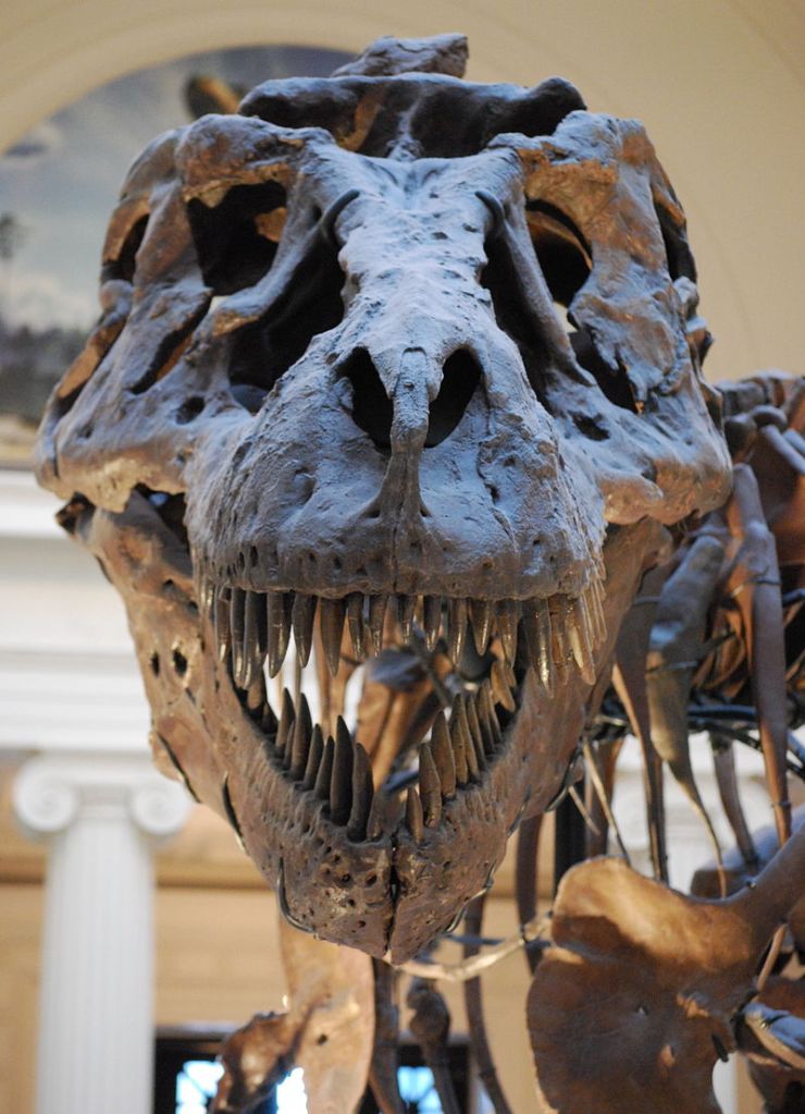
Full-frontal skull of ‘Sue’, the best-preserved and among the largest specimens of T. rex (Credit: Scott Robert Anselmo, Wikimedia Commons)
Long-term followers of Earth-logs and its predecessor Earth-pages News will have observed my general detachment from the dinosaur hullabaloo, which just runs and runs. That is, except for real hold-the-front-page items. One popped up in the 16 April 2021 issue of Science (Marshall, C.R. et al. 2021. Absolute abundance and preservation rate of Tyrannosaurus rex. Science, v. 372, p. 284-287; DOI:10.1126/science.abc8300). For over two million years in the Late Cretaceous, just before all dinosaurs – except for birds – literally bit the dust, the authors estimated a lot of the dinosaurian poster-childTyrannosaurus rex lurking in North America. I write ‘lurking’ because ‘tyrant lizard the king’ when fully grown was so big that if it ran and fell over, it would have been unable to get up! Tangible evidence from trackways suggests that it ambled from place to place. The leg bones of a 7-tonner would probably have shattered at speeds above 18 km per hour, and accelerating to the speed of a human jogger would, anyhow, have exhausted its energy reserves, But it was agile enough to be an ambush predator; it could even pirouette! And it could crush bones so well that it was able to consume prey entirely. It has been suggested that T. rex may have been a scavenger, at least in old age. Whatever, how is it possible to estimate numbers of any extinct species, let alone dinosaurs?
The stumbling block to getting a result that is better than guesswork is the fossil record of a species. First, it is incomplete, secondly the chance of finding a fossil varies from area to area, depending on all kinds of factors. These include the degree of exposure of sedimentary rock formed by the environment in which they thrived, as well as the vagaries of preservation due to post-mortem scavenging, erosion and water transport. In life the population density of a particularspecies varies between different ecosystems and from species to species. For instance, more lions can thrive in open rangeland than in wooded environments, whereas the opposite holds for tigers: probably because of different hunting strategies. Many factors such as these conspire to thwart realistic estimates of ancient populations. Studies of living species, however, suggest that population density of an animal species is inversely related to the average body mass of individuals. Take British herbivores: there are many more rabbits than there are deer. On the grasslands of East Africa hyenas and wild dogs outnumber lions. This mass-population relationship (Damuth’s Law) outlined by US ecologist John Damuth also depends on where a species exists in the food chain (its trophic level) as well as its physiology. Yet for living species, populations of flesh-eating mammals of similar mass show a 150-fold variation; a scatter that results from their different habits and habitats and also their energy requirements. Because they are warm-blooded (endothermic), small carnivorous mammals need a greater energy intake than do similar sized, cold-blooded reptiles, which need to eat far less. But not all living reptiles are ectothermic, especially the bigger ones. The Komodo dragon is mesothermic, midway between the two, and uses about a fifth of the energy needed by a similar-sized mammal carnivore. Population densities of dragons in the Lesser Sunda Islands are more than twice those of physiologically comparable mammalian predators.
A number of features suggest that the metabolism of carnivorous dinosaurs lay midway between those of large predatory mammals and big lizards like the Komodo dragon. This is the basic assumption for the analysis by Charles Marshall and colleagues. They did not focus on the biggest T. rex specimens, but on the average, estimated body mass of adults. There are numerous smaller specimens of the beast, but clearly some of these would have been sexually immature. It has been estimated that adulthood would have been achieved by around 15 years. The size data seem to show that achieving sexual maturity was accompanied by a 4 to 5 year growth spurt from the 2 to 3 tonnes of the largest juveniles to reach >7 t in the largest known adults which may have lived into their early 30s. The authors used this range to estimate a mean adult mass of 5.2 t. Taking this parameter and much more intricate factors into account, using intricate Monte Carlo simulations Marshall et al. came up with an estimate of 20 thousand T. rex adults across North America at any one time: but with an uncertainty of between 1,300 to 328,000. Spread over the 2.3 million km2 area of Late Cretaceous North America that lay above sea level their best-estimated population density would have been about 1 individual for every 100 square kilometres. An area the size of California could have had about 3800 adult Tyrannosaurus rex, while there may well have been two in Washington DC. Lest one’s imagination gets overly excited, were tigers and lions living wild today in North America under similar ecological conditions there would have been 12 and 28 respectively in the US capital. Yet those two adult Washingtonian T. rexs would have been unable to catch anything capable of a sustained jog, without keeling over. The juveniles weighing in at up to 3 tonnes would probably have been the real top predators; the smaller, the swifter and thus most fierce. Which leaves me to wonder, “Did the early teenagers catch the prey for their massive parents to chow-down on?”
I have now compiled all the Earth-logs posts from 2019 into PDFs for the categories: Geohazards; Geomorphology; Human Evolution; Miscellaneous; Palaeobiology; Palaeoclimatology; Physical Resources; Planetary Science; Sediments and Stratigraphy, and Tectonics. They are available for download through the Annual logs pull-down in the main menu – just select a category, then scroll down to the2019 list of contents and click on the link.
I hope this format is useful for reference purposes.
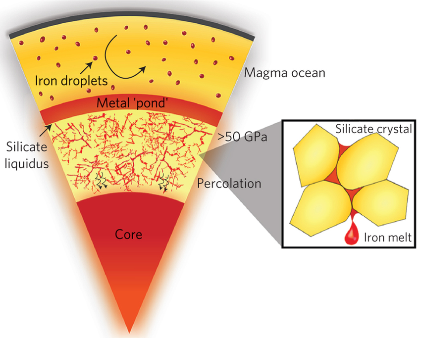
Understandably, the nature of what lies at the centre of the Earth is as much the subject of speculation as tangible evidence. That there must be something very dense within the planet emerged once the Earth’s bulk density was calculated. Because a high proportion of meteorites are dominated by an alloy of the metals iron and nickel, geoscientists adopted that combination as plausible core material. Study of the arrival times around the globe of seismic waves from earthquakes then revealed the actual size of the Earth’s core. Iron-nickel alloy fitted the bill quite nicely. It also fits geochemical evidence, such as the crust and mantle’s depletion in some trace elements that theoretically have an affinity for iron. The fact that seismology showed also that the outer core was molten and able to flow, together with metals’ high electrical conductivity, gave rise to the current concept of the geomagnetic field being generated by a dynamo effect in the core. However the density of Fe-Ni is not ‘quite right’ because the core is somewhat lighter than predicted for the pure alloy under stupendous pressure: it must contain a substantial amount – up to 13% – of lower density materials. Silicon, sulfur and oxygen have been suggested as candidates, with evidence from a variety of minor minerals in metallic meteorites.
A recent model for core formation (credit Crystal Y. Shi et al 2013; DOI: 10.1038/NGEO1956 Fig. 5)
The world is currently awash with models that attempt to throw light on the course of the Covid-19 pandemic. Many are based on highly uncertain data, leading to suggestions by some people that they have become tools for political elites and a means of helping ambitious scientists into the limelight: a sort of fuel for hubris. In the midst of this unprecedented turmoil there has appeared a suggestion (from modelling) that the core also contains abundant hydrogen (Li, Y. et al. 2020. The Earth’s core as a reservoir of water. Nature Geoscience, v. 13, published online; DOI: 10.1038/s41561-020-0578-1). Yunguo Li and colleagues, from University College London, the Chinese Academy of Science and the University of Oslo, explore the idea that the dominant hydrogen of the pre-planetary Solar nebula, which accreted to form the Earth, may have joined iron during core formation. This had been predicted from the thermodynamics of chemical reactions between water and iron. The team takes this further through the geochemical theory that elements and compounds tend to enter other materials preferentially. For example, during partial melting of the crust alkali metals (Na, K etc) are more likely to enter the granitic melt than to remain in the solid residue. Li et al. have used thermodynamics to predict the partitioning of hydrogen between iron and silicate melts under the very high temperature and pressure conditions at the boundary between the core and mantle.
Their calculations suggest that hydrogen then behaves in much the same manner as, say gold and platinum: it becomes ‘iron-loving’ or siderophile and prefers the molten core, as would H2O. The amount that gets in depends on the water content of the molten silicate that eventually becomes the mantle. If the water now making up Earth’s ocean was ‘degassed’ from the mantle during core formation then the original silicate melt would have been ‘wetter’ than it is now. The implication of such early degassing is that the core may contain 5 ‘oceans worth’ of water! The alternative scenario for Earth’s becoming a watery world is the later accretion of, for instance, cometary material. In that case, the early core would have been drier. Yet, the continual subduction of hydrated oceanic lithosphere into the deep mantle during billions of years of plate tectonics would steadily have added water to the core, in the form of iron oxides and hydrogen. So, the core might, in either case, contain several ‘oceans’ of the components of water. One line of indirect evidence is the deficiency in Earth’s actual water of the heavier isotope of hydrogen (deuterium) relative to the D/H ratio of chondritic meteorites. Theory suggests that D has slightly more affinity for joining iron than does H. Substantial water in the core does help explain the core’s apparent low density, but that notion requires as much faith as politicians seem to have in ‘following the Science’ during the current pandemic …
Well, surely we ought to know, 52 years after W. Jason Morgan proposed that the Earth’s surface consists of 12 rigid plates that move relative to each other. But that is not completely true, although most of its mechanisms expressed by external and internal Earth processes are known in great detail. It is still a ‘chicken and egg’ issue: do convective motions in the mantle drive the superficial plates around by dragging at the base of the lithosphere or is it the subduction of plates and slab-pull force that result in overturn of the mantle? Nicolas Coltice of the University of Paris and colleagues from those of Grenoble, Rome and Texas consider that posing plate tectonics in such a manner is an abstraction; rather like the plot for a novel that is yet to be written (Coltice, N. et al. 2019. What drives tectonic plates?Science Advances, v. 5, online eaax4295; DOI: 10.1126/sciadv.aax4295). Instead, all the solid Earth’s vagaries and motions have to be considered as an indivisible whole rather than the traditional piecemeal approach of focussing on the forces that act on the interfaces between plates.
Their approach is to model a combination of mechanisms throughout the Earth as a single, evolving three-dimensional system without the constraint of perfectly rigid plates, which of course they are not. The physical parameters boil down to those involved in relative buoyancy, viscosity, and gradients of temperature, pressure and gravitational potential energy within a spherical planet. Designing the algorithms and running the model on a supercomputer took 9 months to reconstruct the evolution of the planet over 1.5 billion years.
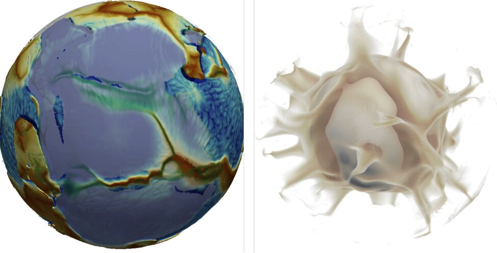
Still from a movie of simulated breakup of a supercontinent, in bland blue-grey, showing what happens at the surface (left) and, at the same time, in the mantle (right): note the influence of rising plumes (credit: Nicolas Coltice)
The result is a remarkable series of unfolding scenarios. In them, 2/3 of the planet’s surface moves faster than does the underlying mantle, suggesting that the surface is dragging the interior. For the remainder, mantle motions exceed those of the surface. Continents are dragged by the underlying mantle to aggregate in supercontinents, which in turn are torn apart by the sinking of cold oceanic slabs. The model takes on a highly visual form, showing in 3-D, for instance: ocean closure and supercontinent assembly; and example of continental breakup; how subduction is initiated.
It will be fascinating to see the reaction of the authors’ peers to their venture, and the extent to which the technicalities of the paper are translated into a form that is suitable for teaching. My suspicion is that most Earth scientists will be happy to stay with the old conceptions until the latter is achieved, and laptops are able to run the model(!)