Seismic tomography provides no evidence that slabs of oceanic lithosphere descend intact through the whole mantle to the core-mantle boundary. It might once have happened when they were capped by abundant high-density rocks, such as Precambrian banded-iron formations. A great many actively descending slabs have been shown to cease sinking, slide sideways and accumulate at depths around 660 and 1000 km. Until recently these discontinuities were been generally ascribed to transitions in the structure of the dominant mafic mineral olivine (Mg2SiO4) in mantle peridotite induced by increasing pressure and temperature. The resulting increases in mantle density supposedly form barriers to further slab descent. Pressure-induced mineral transitions in the slabs themselves that increase their density, such as pyroxene to garnet, may somehow be inhibited thereby leading to stagnation in slab descent. That may be true for the 660 km discontinuity, but for stagnation at 1000 km deep no such density-changing mineral transitions have shown up in high-P high-T mineralogical experiments. Some other process must therefore be responsible for slab descent to that depth. Recent work by geoscientists at several universities in China gives insights into what may be going on (Li, J., Li, K., Li, J. et al 2026. Dual slab stagnation depths controlled by grain-size-induced sporadic low-viscosity zones at around 1000 km depth. Nature Communications DOI: 10.1038/s41467-026-69987-9).
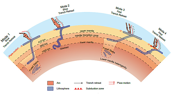
Four different modes of subduction at island arcs. Credit: Li et al. Fig 6
Jing Li and colleagues have focussed on the possibility that changes in the bulk viscosity of the mantle may play an important role. Their approach is twofold: experimental mineral physics and geodynamic modelling. Results suggest that recrystallization in the mantle when deeply penetrating slabs pass through it may patchily reduce the mantle’s grain size and thus its viscosity; the more so with larger volumes of subducted slab material. In turn, the resulting physical heterogeneity probably disrupts the steady downward passage of the slabs; fine-grained, less viscous zones ‘lubricating’ slab penetration, unchanged zones hindering it. The authors link such hypothetical micro-structural processes to modes of subduction that are currently active. They consider four modes of active subduction beneath island arcs with either a slow or a fast rate of trench retreat (see Figure). A slowly retreating trench system combined with low-viscosity patches at depth (Mode 1) results in penetration below 660 km and slab stagnation at 1000 km. Slow trench retreat with a homogenous lower mantle (Mode 2) gives rise to penetration and buckling of the descending slab between 660 and 1000 km. Fast trench retreat with a deeper low-viscosity zone (Mode 3), or with a homogeneous lower mantle (Mode 4) both result in slab stagnation at 660 km.
The models developed by Jing Li et al convincingly simulate various results of seismic tomography beneath island arcs. Interestingly, they suggest that the eventual assimilation of older slab materials into the deeper mantle (‘fossil’ slabs) may play a major role in mineral comminution and reduced mantle strength. That may leave behind low viscosity zones that later subduction may exploit. In fact, there are signs of possible fossil slabs in seismic tomograms more than 1000 km below the present Pacific Ocean floor in the form of zones of high P-wave velocity.
This work shows that plate tectonics is far from ‘done-and-dusted’, the mantle being far from uniform in its properties. Li et al’s results potentially open up new insights into whole-mantle convection, in which older tectonic events influence plate motions that are currently operating and the triggering of plumes rising from the deepest mantle. It also hints that such complex physical mixing of subducted material into the mantle may have resulted in the geochemical heterogeneities that increasingly emerge from analysis of magmas with ultimate origins in the mantle.
The emergence of the eukaryotes – of which we are a late-entry member – has been debated for quite a while. In 2023 Earth-logs reportedthat a study of ‘biomarker’ organic chemicals in Proterozoic sediments suggests that eukaryotes cannot be traced back further than about 900 Ma ago using such an approach. At about the same time another biomarker study showed signs of a eukaryote presence at around 1050 Ma. Both outcomes seriously contradicted a ‘molecular-clock’ approach based on the DNA of modern members of the Eukarya and estimates of the rate of genetic mutation. That method sought to deduce the time in the past when the last eukaryotic common ancestor (LECA) appeared. It pointed to about 2 Ga ago, i.e. a few hundred million years after the Great Oxygenation Event got underway. Since eukaryote metabolism depends on oxygen, the molecular-clock result seems reasonable. The biomarker evidence does not. But were the Palaeo- and Mesoproterozoic Eras truly ‘boring’? A recent paper by Dietmar Müller and colleagues from the Universities of Sydney and Adelaide, Australia definitely shows that geologically they were far from that (Müller, R.D. et al. 2025. Mid-Proterozoic expansion of passive margins and reduction in volcanic outgassing supported marine oxygenation and eukaryogenesis. Earth and Planetary Science Letters, v. 672; DOI: 10.1016/j.epsl.2025.119683).
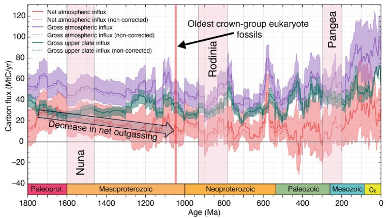
Carbon influx (million tons per year) into tectonic plates and into the ocean-atmosphere system from 1800 Ma to present. The colour bands represent: total carbon influx into the atmosphere (mauve); sequestered in tectonic plates (green); net atmospheric influx i.e. total minus carbon sequestered into plates (orange). The widths of the bands show the uncertainties of the calculated masses shown as darker coloured lines.
From 1800 to 800 Ma two supercontinents– Nuna-Columbia and Rodinia – aggregated nearly all existing continental masses, and then broke apart. Continents had collided and then split asunder to drift. So plate tectonics was very active and encompassed the entire planet, as Müller et al’s palaeogeographic animation reveals dramatically. Tectonics behaved in much the same fashion through the succeeding Neoproterozoic and Phanerozoic to build-up then fragment the more familiar supercontinent of Pangaea. Such dynamic events emit magma to form new oceanic lithosphere at oceanic rift systems and arc volcanoes above subduction zones, interspersed with plume-related large igneous provinces and they wax and wane. Inevitably, such partial melting delivered carbon dioxide to the atmosphere. Reaction on land and in the rubbly flanks of spreading ridges between new lithosphere and dissolved CO2 drew down and sequestered some of that gas in the form of solid carbonate minerals. Continental collisions raised the land surface and the pace of weathering, which also acted as a carbon sink. But they also involved metamorphism that released carbon dioxide from limestones involved in the crustal transformation. This protracted and changing tectonic evolution is completely bound up through the rock cycle with geochemical change in the carbon cycle.
From the latest knowledge of the tectonic and other factors behind the accretion and break-up of Nuna and Rodinia, Müller et al. were able to model the changes in the carbon cycle during the ‘boring billion’ and their effects on climate and the chemistry of the oceans. For instance, about 1.46 Ga ago, the total length of continental margins doubled while Nuna broke apart. That would have hugely increased the area of shallow shelf seas where living processes would have been concentrated, including the photosynthetic emission of oxygen. In an evolutionary sense this increased, diversified and separated the ecological niches in which evolution could prosper. It also increased the sequestration of greenhouse gas through reactions on the flanks of a multiplicity of oceanic rift systems, thereby cooling the planet. Translating this into a geochemical model of the changing carbon cycle (see figure) suggests that the rate of carbon addition to the atmosphere (outgassing) halved during the Mesoproterozoic. The carbon cycle and probable global cooling bound up with Nuna’s breakup ended with the start of Rodinia’s aggregation about 1000 Ma ago and the time that biomarkers first indicate the presence of eukaryotes.
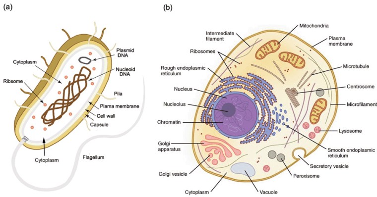
Simplified structures of (a) a prokaryote cell; (b) a simple eukaryote animal cell. Plants also contain organelles called chloroplasts
So, did tectonics play a major role in the rise of the Eukarya? Well, of course it did, as much as it was subsequently the changing background to the appearance of the Ediacaran animals and the evolutionary carnival of the Phanerozoic. But did it affect the billion-year delay of ‘eukaryogenesis’ during prolonged availability of the oxygen that such a biological revolution demanded? Possibly not. Lyn Margulis’s hypothesis of the origin of the basic eukaryote cell by a process of ‘endosymbiosis’ is still the best candidate 50 years on. She suggested that such cells were built from various forms of bacteria and archaea successively being engulfed within a cell wall to function together through symbiosis. Compared with prokaryote cells those of the eukaryotes are enormously complex. At each stage the symbionts had to be or become compatible to survive. It is highly unlikely that all components entered the relationship together. Each possible kind of cell assembly was also subject to evolutionary pressures. This clearly was a slow evolutionary process, probably only surviving from stage to stage because of the global presence of a little oxygen. But the eukaryote cell may also have been forced to restart again and again until a stable form emerged.
A symposium hosted by the Royal Society in 1965 aimed at resurrecting Alfred Wegener’s hypothesis of continental drift. During the half century since Wegener made his proposal in 1915, it had been studiously ignored by most geologists. The majority had bumbled along with the fixist ideology of their Victorian predecessors. The symposium launched what can only be regarded as a revolution in the Earth Sciences. In the three years following the symposium, the basic elements of plate tectonics had emerged from a flurry of papers, mainly centred on geophysical evidence. Geology itself became part of this cause célèbre through young scientists eager to make a name for themselves. The geological history of Britain, together with that of the eastern North America, became beneficiaries only four years after the Royal Society meeting (Dewey, J. 1969. Evolution of the Appalachian/Caledonian Orogen. Nature222, 124–129; DOI: 10.1038/222124a0).
In Britain John Dewey, like a few other geologists, saw plate theory as key to understanding the many peculiarities revealed by geological structure, igneous activity and stratigraphy of the early Palaeozoic. These included very different Cambrian and Ordovician fossil assemblages in Scotland and Wales, now only a few hundred kilometres apart. The Cambro-Ordovician of NW Scotland was bounded to the SE by a belt of highly deformed and metamorphosed Proterozoic to Ordovician sediments and volcanics forming the Scottish Highlands. That was terminated to the SE by a gigantic fault zone containing slivers of possible oceanic lithosphere. The contorted and ‘shuffled’ Ordovician and Silurian sediments of the Southern Uplands of Scotland. The oldest strata seemed to have ocean-floor affinities, being deposited on another sliver of ophiolites. A few tens of km south of that there was a very different Lower Palaeozoic stratigraphy in the Lake District of northern England. It included volcanic rocks with affinities to those of modern island arcs. A gap covered by only mildly deformed later Palaeozoic shelf and terrestrial sediments, dotted by inliers of Proterozoic sediments and volcanics separated the Lake District from yet another Lower Palaeozoic assembly of arc volcanics and marine sediments in Wales. Intervening in Anglesey was another Proterozoic block of deformed sediments that also included ophiolites.
Dewey’s tectonic assessment from this geological hodge-podge, which had made Britain irresistible to geologists through the 19th and early 20th centuries, was that it had resulted from blocks of crust (terranes), once separated by thousands of kilometres, being driven into each other. Britain was thus formed by the evolution and eventual destruction of an early Palaeozoic ocean, Iapetus: a product of plate tectonics. Scotland had a fundamentally different history from England and Wales; the unification of several terranes having taken over 150 Ma of diverse tectonic processes. Dewey concluded that the line of final convergence lay at a now dead, major subduction zone – the Iapetus Suture – roughly beneath the Solway Firth. During the 56 years since Dewey’s seminal paper on the Caledonian-Appalachian Orogeny details and modifications have been added at a rate of around one to two publications per year. The latest seeks to date when and where the accretion of 6 or 7 terranes was finally completed (Waldron, J.W.F. et al. 2025. Is Britain divided by an Acadian suture?Geology, v. 53, p. 847–852; DOI: 10.1130/G53431.1).
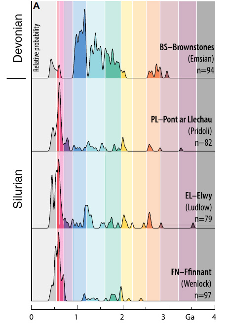
Kernel density plots – smoothed versions of histograms – of detrital zircon ages in Silurian and Devonian sandstones from Wales. The bracketed words are stratigraphic epochs. Credit: Waldron et al. 2025, Fig 3A
John Waldron and colleagues from the University of Alberta and Acadia University in Canada and the British Geological Survey addressed this issue by extracting zircons from four late Silurian and early Devonian sandstones in North and South Wales. These sediments had been deposited between 433 and 393 Ma ago at the southernmost edge of the British Caledonide terrane assemblage towards the end of terrane assembly. The team dated roughly 250 zircons from each sandstone using the 207Pb/206Pb and 206Pb/238U methods. Each produced a range of ages, presumed to be those of igneous rocks from whose magma the zircon grains had crystallised. These data are expressed as plots of probable frequency against age. Each pattern of ages is assumed to be a ‘fingerprint’ for the continental crust from which the zircons were eroded and transported to their resting place in their host sediment. In this case, the researchers were hoping to see signs of continental crust from the other side of the Caledonian orogen; i.e. from the Precambrian basement of the Laurentia continent.
The three late-Silurian sediments showed distinct zircon-age peaks around 600 Ma and a spread of smaller peaks extending to 2.2 Ga. This tallied with a sediment source in Africa, from which the southernmost Caledonian terrane was said to have split and moved northwards. The Devonian sediment lacked signs of such an African ‘heritage’ but had a prominent age peak at about 1.0 Ga, absent from the Welsh Silurian sediments. Not only is this a sign of different sediment provenance but closely follows the known age of a widespread magmatic pulse in the Laurentian continent. So, sediment transport from the opposite side of the Iapetus Ocean across the entire Caledonian orogenic belt was only possible after the end of the Silurian Period at around 410 Ma. There must have been an intervening barrier to sediment movement from Laurentia before that, such as deep ocean water further north. Previous studies from more northern Caledonian terranes show that Laurentian zircons arrived in the Southern Uplands of Scotland and the English Lake District around 432 Ma in the mid-Silurian. Waldron et al. suggest, on these grounds that the suture marking the final closure of the Iapetus Ocean lies between the English Lake District and Anglesey, rather than beneath the Solway. They hint that the late-Silurian to early Devonian granite magmatism that permeated the northern parts of the Caledonian-Appalachian orogen formed above northward subduction of the last relics of Iapetus, which presaged widespread crustal thickening known as the Acadian orogeny in North America.
Readers interested in this episode of Earth history should download Waldron et al.’s paper for its excellent graphics, which cannot be reproduced adequately here.
About 70 Ma ago the magnetic striping of the Indian Ocean floor suggests that the Indian subcontinent was then moving towards the huge, almost stationary Eurasian continent at about 8 cm per year. Over the next 5 Ma this convergence rate underwent a tectonically startling acceleration to reach 18 cm yr-1 by around the time of the Cretaceous-Palaeogene boundary (65 Ma): more than doubling the approach rate. Thereafter it slowed, eventually to a few centimetres per year once collision and building of the Himalayan mountain belt were more or less complete about 30 Ma ago. This cannot easily be explained by a speeding up of the sea-floor spreading rate at an Indian Ocean ridge to the south, 18 cm yr-1 being as fast as tectonic forces can manage at present. At that time ocean floor to the north of India was being subducted beneath Eurasia, and basaltic volcanism was flooding what is now the Deccan Plateau on western India. A couple of suggestions have been made: two northward subduction zones may have developed or the mantle plume feeding the Deccan flood basalts may have driven the tectonic acceleration. A third possibility is that the subduction was somehow lubricated. That approach has recently been considered by geoscientists from China and Singapore (Zhou, H. et al. 2024. India–Eurasia convergence speed-up by passive-margin sediment subduction. Nature, v. 635, p. 114-120; DOI: 10.1038/s41586-024-08069-6).
Hao Zhou and colleagues studied the isotopic and trace-element geochemistry of volcanic and plutonic igneous complexes to the north of the Himalaya. They were emplaced in arc environments in three stages: from 98 to 89; 65 to 60; and 57 to 50 Ma. In this tectonic setting fluids rise from the subducted slab to induce the mantle part of the overriding lithosphere to partially melt. That yields magmas which penetrate the crust above. The first and last magmatic events produced similar isotopic and trace-element ‘signatures’, which suggest fluids rose from subducted ocean lithosphere. But those in the latest Cretaceous to earliest Palaeocene are markedly different. Instead of showing signs of their magmas being entirely mantle derived like the earlier and later groups, the 65 to 60 Ma rocks exhibit clear evidence of partial melting having incorporated materials that had originated in older continental crust. The authors suggest that this crustal contamination stemmed from sediments that had been deposited at the northern margin of the Indian subcontinent during the Mesozoic. These sediments had formed by weathering of the ancient rocks that underpin India, transport of the debris by rivers and deposition on the seafloor as water-saturated sands, silts and clays. Once those sediments were subducted beneath what is now Tibet they would yield fluids with a geochemical ‘fingerprint’ inherited from old continental crust. Moreover, far more fluids than subducted oceanic crust could ever release would rise into the overriding lithosphere than.
The fluids rising from a subducted wedge of sediments may have reduced friction between the overriding Eurasian lithosphere and the subducted slab derived from the Indian tectonic plate. That scenario would not only have lubricated subduction, but allowed compressive forces in the overriding lithosphere to relax. Both would have allowed convergence of the two plates to move significantly faster as the sediments were progressively consumed. Once completed, convergence would have slowed without such ‘lubrication’.Earlier continent-continent collision zones, such as those that united Pangaea and older supercontinents may well have involved such tectonic surges. And the same kind of process may eventually speed up the reassembly of the latest distribution of continents.
Watch an animation of the India-Eurasia convergence (just over 3 minutes long)compiled by Christopher Scotese of Northwestern University in Evanston, Illinois, USA, which is a component of his Paleomap Project. It starts by following India from its current position to its origin in the break-up of Gondwanaland ~100 Ma ago. The last half reverses the motions to show India’s slow collision with Eurasia.
In 1961 ten scientists interested in a search for extra-terrestrial intelligence met at Green Bank, West Virginia, USA, none of whom were geologists or palaeontologists. The participants called themselves “The Order of the Dolphin”, inspired by the thorny challenge of discovering how small cetaceans communicated: still something of a mystery. To set the ball rolling, Frank Drake an American astrophysicist and astrobiologist, proposed an algorithm aimed at forecasting the number of planets elsewhere in our galaxy on which ‘active, communicative civilisations’ (ACCs) might live. The Drake Equation is formulated as:
ACCs = R* · fp · ne · fl · fi · fc · L
where R* = number of new stars formed per year, fp = the fraction of stars with planetary systems, ne = the average number of planets that could support life (habitable planets) per planetary system, fl = the fraction of habitable planets that develop primitive life, fi = the fraction of planets with life that evolve intelligent life and civilizations, fc = the fraction of civilizations that become ACCs,L = the length of time that ACCs broadcast radio into space. A team of then renowned scientists from several disciplines discussed what numbers to attach to these parameters. Their ‘educated guesses’ were: R* – one star per year; fp – one fifth to one half of all stars will have planets; ne – 1 to 5 planets per planetary system will be habitable; of which 100% will develop life (fl) and 100% (fi) will eventually develop intelligent life and civilisations; of those civilisations 10 to 20 % (fc) will eventually develop radio communications; which will survive for between a thousand years and 100 Ma (L). Acknowledging the great uncertainties in all the parameters, Drake inferred that between 103 and 108 ACCs exist today in the Milky Way, which is ~100 light years across and contains 1 to 4 x 10¹¹ stars).
Today the values attached to the parameters and the outcomes seem absurdly optimistic to most people, simply because, despite 4 decades of searching by SETI there have been no signs of intelligible radio broadcasts from anywhere other than Earth and space probes launched from here. This is humorously referred to as the Fermi Paradox. There are however many scientists who still believe that we are not alone in the galaxy, and several have suggested reasons why nothing has yet been heard from ACCs. Robert Stern of the University of Texas (Dallas), USA and Taras Gerya of ETH-Zurich, Switzerland have sought clues from the history of life on Earth and that of the inorganic systems from which it arose and in which it has evolved that bear on the lack of any corrigible signals in the 63 years since the Drake Equation (Stern, R.J & Gerya, T.V. 2024. The importance of continents, oceans and plate tectonics for the evolution of complex life: implications for finding extraterrestrial civilizations. Nature (Scientific Reports), v. 14, article 8552; DOI: 10.1038/s41598-024-54700-x – definitely worth reading). Of course, Stern and Gerya too are fascinated by the scientific question as to whether or not there are ‘active, communicative civilisations’ elsewhere in the cosmos. Their starting point is that the Drake Equation is either missing some salient parameters, or that those it includes are assigned grossly optimistic magnitudes.
Life seems to have been present on Earth 3.8 Ga ago but multicelled animals probably arose only in the Late Neoproterozoic since 1.0 Ga ago. So here it has taken a billion years for their evolution to achieve terrestrial ACC-hood. Stern and Gerya address what processes favour life and its rapid evolution. Primarily, life depends on abundant liquid water: i.e. on a planet within the ‘Goldilocks Zone’ around a star. The authors assume a high supply of bioactive compounds – organic carbon, ammonium, ferrous iron and phosphate to watery environments. Phosphorus is critical to their scenario building. It is most readily supplied by weathering of exposed continental crust, but demands continual exposure of fresh rock by erosion and river transport to maintain a steady supply to the oceans. Along with favourable climatic conditions, that can only be achieved by an oxidising environment that followed the Great Oxidation Event (2.4 to 2.1 Ga) and continual topographic rejuvenation by plate tectonics.
A variety of Earth-logs posts have discussed various kinds of evidence for the likely onset of plate tectonics, largely focussing on the Hadean and Archaean. Stern and Gerya prefer the Proterozoic Eon that preserves more strands of relevant evidence, from which sea-floor spreading, subduction and repeated collision orogenies can confidently be inferred. All three occur overwhelmingly in Neoproterozoic and Phanerozoic times. Geologists often refer to the whole of the Mesoproterozoic and back to about 2.0 Ga in the Palaeoproterozoic as the ‘Boring Billion’ during which carbon isotope data suggest very little change in the status of living processes: they were present but nothing dramatic happened after the Great Oxidation Event. ‘Hard-rock’ geology also reveals far less passive extensional events that indicate continental break-up and drift than occur after 1.0 Ga and to the present. It also includes a unique form of magmatism that formed rocks dominated by sodium-rich feldspar (anorthosites) and granites that crystallised from water-poor magmas. They are thought to represent build-ups of heat in the mantle unrelieved by plate-tectonic circulation. Before the ‘Boring Billion’ such evidence as there is does point to some kind of plate motions, if not in the modern style.
How different styles of tectonics influence living processes differently: a single stagnant ‘lid’ versus plate tectonics. (Credit: Stern and Gerya, Fig 2)
Stern and Gerya conclude that the ‘Boring Billion’ was dominated by relative stagnation in the form of lid tectonics. They compare the influence of stagnant ‘lid’ tectonics on life and evolution with that of plate tectonics in terms of: bioactive element supply; oxygenation; climate control; habitat formation; environmental pressure (see figure). In each case single lid tectonics is likely to retard life and evolution, whereas plate tectonics stimulates them as it has done from the time of Snowball Earth and throughout the Phanerozoic. Only one out of 8 planets that orbit the sun displays plate tectonics and has both oceans and continents. Could habitable planets be a great deal rarer than Drake and his pals assumed? [look at exoplanets in Wikipedia] Whatever, Stern and Gerya suggest that the seemingly thwarted enthusiasm surrounding the Drake Equation needs to be tempered by the addition of two new terms: the fraction of habitable exoplanets with significant continents and oceans (foc)and the fraction of them that have experienced plate tectonics for at least half a billion years (fpt). They estimate foc to be on the order of 0.0002 to 0.01, and suggest a value for fpt of less than 0.17. Multiplied together yields value between less than 0.00003 and 0.002. Their incorporation in the Drake Equation drastically reduces the potential number of ACCs to between <0.006 and <100,000, i.e. to effectively none in the Milky Way galaxy rising to a still substantial number
There are several other reasons to reject such ‘ball-parking’ cum ‘back-of-the-envelope’ musings. For me the killer is that biological evolution can never be predicted in advance. What happened on our home world is that the origin and evolution of life have been bound up with the unique inorganic evolution of the Solar System and the Earth itself over more than 4.5 billion years. That ranges in magnitude from the early collision with another, Mars-sized world that reset the proto-Earth’s geochemistry and created a large moon whose gravity has cycled the oceans through tides and changed the length of the day continually for almost the whole of geological history. At least once, at the end of the Cretaceous Period, a moderately sized asteroid in unstable orbit almost wiped out life at an advanced stage in its evolution. During the last quarter billion years internally generated geological forcing mechanisms have repeatedly and seriously stressed the biosphere in roughly 36 Ma cycles (Boulila, S. et al. 2023. Earth’s interior dynamics drive marine fossil diversity cycles of tens of millions of years. Proceedings of the National Academy of Sciences, v. 120 article e2221149120; DOI: 10.1073/pnas.2221149120). Two outcomes were near catastrophic mass extinctions, at the ends of the Permian and Triassic Periods, from which life struggled to continue. As well as extinctions, such ‘own goals’ reset global ecosystems repeatedly to trigger evolutionary diversification based on the body plans of surviving organisms.
Such unique events have been going on for four billion years, including whatever triggered the Snowball Earth episodes that accompanied the Great Oxygenation Event around 2.4 Ga and returned to coincide with the rise of multicelled animals during the Cryogenian and Ediacaran Periods of the Late Neoproterozoic. For most of the Phanerozoic a background fibrillation of gravitational fields in the Solar System has occasionally resulted in profound cycling between climatic extremes and their attendant stresses on ecosystems and their occupants. The last of these coincided with the evolution of humanity: the only creator of an active, communicative civilisation of which we know anything. But it took four billion years of a host of diverse vagaries, both physical and biological to make such a highly unlikely event possible. That known history puts the Drake Equation firmly in its place as the creature of a bunch of self-publicising and regarding, ambitious academics who in 1961 basically knew ‘sweet FA’. I could go on … but the wealth of information in Stern and Gerya’s work is surely fodder for a more pessimistic view of other civilisations in the cosmos.
Someone – I forget who – provided another, very practical reason underlying the lack of messages from afar. It is not a good idea to become known to all and sundry in the galaxy, for fear that others might come to exploit, enslave and/or harvest. Earth is still in a kind of imperialist phase from which lessons could be drawn!
Tangible signs of past subduction take the form of rocks whose mineralogy shows that they have been metamorphosed under conditions of high pressure and low temperature, and then returned to the surface somehow. Ocean-crust basaltic rocks become blueschist and eclogite. The latter is denser than mantle peridotite so that oceanic lithosphere can sink and be recycled. That provides the slab-pull force, which is the major driver of plate tectonics. Unfortunately, neither blueschists nor eclogites are found in metamorphic complexes older than about 800 Ma. This absence of direct proof of subduction and thus modern style plate tectonics has resulted in lively discussion and research seeking indirect evidence for when it did begin, the progress of which since 2000 you can follow through the index for annual logs about tectonics. An interesting new approach emerged in 2017 that sought a general theory for the evolution of silicate planets, which involves the concept of ‘lid tectonics’. A planet in a stagnant-lid phase has a lithosphere that is weak as a result of high temperatures: indeed so weak and warm that subduction was impossible. Stagnant-lid tectonics does not recycle crustal material back to its source in the mantle and it simply builds up the lithosphere. Once planetary heat production wanes below a threshold level that permits a rigid lithosphere, parts of the lid can be driven into the mantle. The beginnings of this mobile-lid phase and thus plate tectonics of some kind involves surface materials in mantle convection: the may be recycled.
Cartoon of possible Hadean stagnant lid tectonics, dominated by mantle plumes. (Credit: Bédard, J.H. 2018, Fig 3B, DOI: 10.1016/j.gsf.2017.01.005)
A group of geochemists from China, Canada and Australia have sought evidence for recycled crustal rocks from silicon and oxygen isotopes in the oldest large Archaean terrane, the 4.0 Ga old Acasta Gneiss Complex in northern Canada (Zhang, Q. and 10 others 2023. No evidence of supracrustal recycling in Si-O isotopes of Earth’s oldest rocks 4 Ga ago. Science Advances, v.9, article eadf0693; DOI: 10.1126/sciadv.adf0693). Silicon has three stable isotopes 28Si, 29Si, and 30Si. As happens with a number of elements, various geochemical processes are able to selectively change the relative proportions of such isotopes: a process known as isotope fractionation. As regards silicon isotopes used to chart lithosphere recycling, the basic steps are as follows: Organisms that now remove silicon from solution in seawater to form their hard parts and accumulate in death as fine sediments like flint had not evolved in the Archaean. Because of that reasonable supposition it has been suggested that seawater during the Archaean contained far more dissolved silicon than it does now. Such a rich source of Si would have entered Archaean oceanic crust and ocean-floor sediments to precipitate silica ‘cement’. The heaviest isotope 30Si would have left solution more easily than the lighter two. Should such silicified lithosphere have descended to depths in the mantle where it could partially melt the anomalously high 30Si would be transferred to the resulting magmas.
Proportions of 30Si in zircons, quartz and whole rock for Acasta gneisses (coloured), other Archaean areas (grey) and Jack Hills zircons (open circles. Vertical lines are error bars. (Credit: simplified from Zhang et al. Fig 1)
Stable-isotope analyses by Zhang et al. revealed that zircon and quartz grains and bulk rock samples from the Acasta gneisses, with undisturbed U-Pb ages, contain 30Si in about the same proportions relative to silicon’s other stable isotopes as do samples of the mantle. So it seems that the dominant trondhjemite-tonalite-granodiorite (TTG) rocks that make up the oldest Acasta gneisses were formed by partial melting of a source that did not contain rocks from the ocean crust. Yet the Acasta Gneiss Complex also contains younger granitic rocks (3.75 to 3.50 Ga) and they are significantly more enriched in 30Si, as expected from a deep source that contained formerly oceanic rocks. A similar ‘heavy’ silicon-isotope signature is also found in samples from other Archaean terranes that are less than 3.8 Ga old. Thus a major shift from stagnant-lid tectonics to the mobile-lid form may have occurred at the end of the Hadean. But apart from the Acasta Gneiss Complex only one other, much smaller Hadean terrane has been discovered, the 4.2 Ga Nuvvuagittuq Greenstone Belt. It occupies a mere 20 km2 on the eastern shore of Hudson Bay in Canada, and appears to be a sample of Hadean oceanic crust. It does include TTG gneisses, but they are about 3.8 Ga old and contain isotopically heavy silicon. So it seems unlikely that testing this hypothesis with silicon-isotope data from other Hadean gneissic terranes will be possible for quite a while, if at all.
How the Earth has been shaped has depended to a large extent on a very simple variable among rocks: their density. Contrasts in density between vast rock masses are expressed when gravity attempts to maintain a balance of forces. The abrupt difference in elevation of the solid surface at the boundaries of oceans and continents – the Earth’s hypsometry – stems from the contrasted densities of continental and oceanic crust: the one dominated by granitic rocks (~2.8 t m-3) the other by those of basaltic composition (~ 3.0 t m-3). Astronomers have estimated that Earth’s overall density is about 5.5 t m-3 – it is the densest planet in the Solar System. The underlying mantle makes up 68% of Earth’s mass, with a density that increases with depth from 3.3 to 5.4 t m-3 in a stepwise fashion, at a number of discontinuities, because mantle minerals undergo changes induced by pressure. The remaining one third of Earth’s mass resides in the iron-nickel core at densities between 9.5 to 14.5 t m-3. Such density layering is by no means completely stable. Locally increased temperatures in mantle rocks reduce their density sufficiently for masses to rise convectively to be replaced by cooler ones, albeit slowly. By far the most important form of convection affecting the lithosphere involves the resorption of oceanic lithosphere plates at destructive margins, which results in subduction. This is thought to be due to old, cold oceanic basalts undergoing metamorphism as pressure increases during subduction. They are transformed at depth to a mineral assemblage (eclogite) that is denser (3.4 to 3.5 t m-3) than the enveloping upper mantle. That density contrast is sufficient for gravity to pull slabs of oceanic lithosphere downwards. This slab-pull force is transmitted through oceanic lithosphere that remains at the surface to become the dominant driver of modern plate tectonics. As a result, extension of the surface oceanic lithosphere at constructive margins draws mantle upwards to partially melt at reduced pressure, thus adding new basaltic crust at mid-ocean rift systems to maintain a form of mantle convection. Seismic tomography shows that active subducted slabs become ductile about 660 km beneath the surface and below that no earthquakes are detected. Quite possibly, the density of the reconstituted lithospheric slab becomes less than that of the mantle below the 660 km discontinuity. So the subducted slab continues by moving sideways and buckling in response to the ‘push’ from its rigid upper parts above. But it has been suggested that some subducted slabs do finally sink to the core-mantle boundary, but that is somewhat conjectural.
Typical banded iron formation
There are sedimentary rocks whose density at the surface exceeds that of the upper mantle: banded iron formations (BIFs) that contain up to 60% iron oxides (mainly Fe2O3) and have an average density at the surface of around 3.5 t m-3. BIFs formed mainly in the late Archaean and early Proterozoic Eons (3.2 to 1.0 Ga) and none are known from the last 400 Ma. They formed when soluble iron-2 (Fe2+) – being added to ocean water by submarine hydrothermal activity –was precipitated as Fe3+ in the form of iron oxide (Fe2O3) where oxygen was present in ocean water. With little doubt this happened only in shallow marine basins where cyanobacteria that appeared about 3.5 Ga ago had sufficient sunlight to photosynthesise. Until about 2.4 Ga the atmosphere and thus the bulk of ocean water contained very little oxygen so the oceans were pervaded by soluble iron so that BIFs were able to form wherever such biological activity was going on. Conceivably (but not proven), that BIF-forming biochemical reaction may even have operated far from land in ocean surface water, slowly to deposit Fe2O3 on the deep ocean floor. After 2.4 Ga oxygen began to build in the atmosphere after the Great Oxidation Event had begon. That time was also when the greatest production of BIFs took place. Strangely, the amount of BIF in the geological record fell during the next 600 Ma to rise again to a very high peak at 1.8 Ga. Since there must have been sufficient soluble iron and an increasing amount of available oxygen for BIFs to form throughout that ‘lean’ period the drop in BIF formation is paradoxical. After 1.0 Ga BIFs more or less disappear. By then so much oxygen was present in the atmosphere and from top to bottom in ocean water that soluble iron was mostly precipitated at its hydrothermal source on the ocean floor. Incidentally, modern ocean surface water far from land contains so little dissolved iron that little microbiological activity goes on there: iron is an essential nutrient so the surface waters of remote oceans are effectively ‘wet deserts’.
Plots of probability of LIPs and BIFs forming at the Earth’s surface during Precambrian times, based on actual occurrences (Credit: Keller, et al., modified Fig 1A)
Spurred by the fact that if a sea-floor slab dominated by BIFs was subducted it wouldn’t need eclogite formation to sink into the mantle, Duncan Keller of Rice University in Texas and other US and Canadian colleagues have published a ‘thought experiment’ using time-series data on LIPs and BIFs compiled by other geoscientists (Keller, D.S. et al. 2023. Links between large igneous province volcanism and subducted iron formations. Nature Geoscience, v. 16, article; DOI: 10.1038/s41561-023-01188-1.). Their approach involves comparing the occurrences of 54 BIFs through time with signs of activity in the mantle during the Palaeo- and Mesoproterozoic Eras, as marked by large igneous provinces (LIPs) during that time span. To do this they calculated the degree of correlation in time between BIFs and LIPs. The authors chose a minimum area for LIPs of 400 thousand km2 – giving a total of 66 well-dated examples. Because the bulk of Precambrian flood-basalt provinces, such as occurred during the Phanerozoic, have been eroded away, most of their examples are huge, well-dated dyke swarms that almost certainly fed such plateau basalts. Rather than a direct time-correlation, what emerged was a match-up that covered 74% of the LIPs with BIFs that had formed about 241 Ma earlier. They also found a less precise correlation between LIPs associated with 241 Ma older BIFs and protracted periods of stable geomagnetic field, known as ‘superchrons’. These are thought by geophysicists to be influenced by heat flow through the core-mantle boundary (CMB).
The high bulk density of BIFs at the surface would be likely to remain about 15 % greater than that of peridotite as pressure increased with depth in the mantle. Such slabs could therefore penetrate the 660 mantle discontinuity. Their subduction would probably result in their eventually ‘piling up’ in the vicinity of the CMB. The high iron content of BIFs may also have changed the way that the core loses heat, thereby triggering mantle plumes. Certainly, there is a complex zone of ultra-low seismic velocities (ULVZ) that signifies hot, ductile material extending above the CMB. Because BIFs’ high iron-content makes them thermally highly conductive compared with basalts and other sediments, they may be responsible. Clearly, Keller et al’s hypothesis is likely to be controversial and they hope that other geoscientists will test it with new or re-analysed geophysical data. But the possibility of BIFs falling to the base of the mantle spectacularly extends the influence of surface biological processes to the entire planet. And, indeed, it may have shaped the later part of its tectonic history having changed the composition of the deep mantle. The interconnectedness of the Earth system also demands that the consequences – plumes and large igneous provinces – would have fed back to the Precambrian biosphere. See also: Iron-rich rocks unlock new insights into Earth’s planetary history, Science Daily, 2 June 2023
Modern plate tectonics is largely driven by slab-pull: a consequence of high-pressure, low-temperature metamorphism of the oceanic crust far from its origin at an oceanic ridge. As it ages, basaltic crust cools, become increasingly hydrated by hydrothermal circulation of seawater through it and its density increases. That is why the abyssal plains of the ocean floor are so deep relative to the shallower oceanic ridges where it formed. Due to the decrease in the Earth’s internal heat production by decay of radioactive isotopes, once oceanic lithosphere breaks and begins to descend high-P low-T metamorphism transforms the basaltic crust to a denser form: eclogite, in which the dense, anhydrous minerals garnet and sodium-rich pyroxene (omphacite) form. Depending on local heat flow, the entire oceanic slab may then exceed the density of the upper mantle to drag the plate downwards under gravity. Metamorphic reactions of any P-T regime creates minerals less capable of holding water and drive H2O-rich fluids upwards into the overriding lithosphere, thus inducing it to partially melt. Magmas produced by this create volcanism at the surface, either at oceanic island arcs or near to continental margins, depending on the initial position of the plate subduction.
A direct proof of active subduction in the geological record is the presence of eclogite and related blueschists. Such rocks are unknown before 2100 Ma ago (mid-Palaeoproterozoic of the Democratic Republic of Congo) but there are geochemical means of ‘sensing’ plate tectonic control over arc magmatism (See:So, when did plate tectonics start up? February 2016). The relative proportions of rare-earth elements in ancient magmatic rocks that make up the bulk of continental crust once seemed to suggest that plate tectonics started at the end of the Archaean Eon (~2500 Ma). That method, however, was quite crude and has been superseded by looking in great detail at the geochemistry of the Earth’s most durable mineral: zircon (ZrSiO4), which began more than two decades ago. Minute grains of that mineral most famously have pushed back the geological record into what was long believed to be half a billion years with no suggestion of a history: the Hadean. Zircon grains extracted from a variety of ancient sediments have yielded U-Pb ages of their crystallisation from igneous magma that extend back 4.4 billion years (Ga) (see:Pushing back the “vestige of a beginning”;January 2001).
Though simple in their basic chemical formula, zircons sponge-up a large range of other trace elements from their parent magma. So, in a sense, each tiny grain is a capsule of their geochemical environment at the time they crystallised. In 2020 Australian geochemists presented the trace-element geochemistry of 32 zircons extracted from a 3.3 Ga old sedimentary conglomerate in the Jack Hills of Western Australia, which lie within an ancient continental nucleus or craton. They concluded that those zircons mainly reveal that they formed in andesitic magmas, little different from the volcanic rocks that are erupted today above subduction zones. From those data it might seem that some form of plate tectonics has been present since shortly after the Earth’s formation. Oxygen-isotope data from zircons are useful in checking whether zircons had formed in magmas derived directly from partial melting of mantle rocks or by recycling of crustal magmatic rocks through subduction. Such a study in 2012 (see: Charting the growth of continental crust; March 2012) that used a very much larger number of detrital zircon grains from Australia, Eurasia, North America, and South America seemed, in retrospect, to contradict a subduction-since-the-start view of Earth dynamics and crust formation. Instead it suggested that recycling of crust, and thus plate-tectonic subduction, first showed itself in zircon geochemistry at about 3 Ga ago.
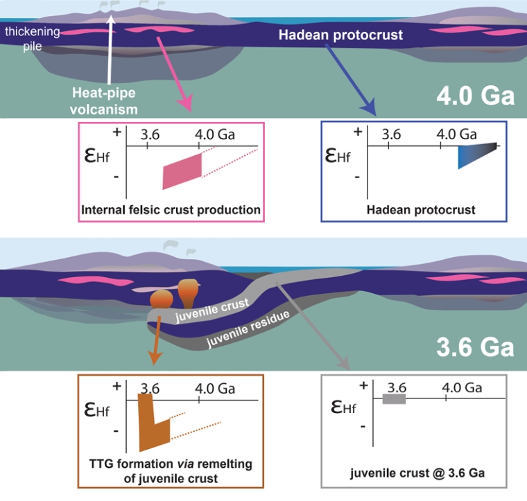
Detailed chemical and isotopic analysis of zircons using a variety of instruments has steadily become faster and cheaper. Actually finding the grains is much easier than doing interesting things with them. It is a matter of crushing the host rock to ‘liberate’ the grains. Sedimentary hosts that have not been strongly metamorphosed are much more tractable than igneous rocks. Being denser than quartz, the dominant sedimentary mineral, zircon can be separated from it along with other dense, trace minerals, and from them in turn by various methods based on magnetic and electrical properties. Zircons can then be picked out manually because of their distinctive colours and shapes. A tedious process, but there are now several thousand fully analysed zircons aged between 3.0 to 4.4 Ga, from eleven cratons that underpin Australia, North America, India, Greenland and southern Africa. The latest come from a sandstone bed laid down about 3.31 Ga ago in the Barberton area of South Africa (Drabon, N. et al. 2022. Destabilization of Long‐Lived Hadean Protocrust and the Onset of Pervasive Hydrous Melting at 3.8 Ga. AGU Advances, v. 3, article e2021AV000520; DOI: 10.1029/2021AV000520). The authors measured lutetium (Lu), hafnium (Hf) and oxygen isotopes, and concentrations of a suite of trace element in 329 zircons from Barberton dated between 3.3 to 4.15 Ga.
A schematic model of transition from Hadean-Eoarchaean lid tectonics to a type of plate tectonics that subsequently evolved to its current form, based on hafnium isotope data in ancient zircons (credit: Bauer et al. 2020; Fig 3)
The Hf isotopes show two main groups relative to the values for chondritic meteorites (assumed to reflect the composition of the bulk Earth). Zircons dated between 3.8 and 4.15 Ga all show values below that expected for the whole Earth. Those between 3.3 and 3.8 Ga show a broader range of values that extend above chondritic levels. The transition in data at around 3.8 Ga is also present in age plots of uranium relative to niobium and scandium relative to ytterbium, and to a lesser extent in the oxygen isotope data. On the basis of these data, something fundamentally changed in the way the Earth worked at around 3.8 Ga. Nadja Drabon and colleagues ascribe the chemical features of Hadean and Eoarchaean zircons to an early protocrust formed by melting of chemically undepleted mantle. This gradually built up and remained more or less stable for more than 600 Ma, without being substantially remelted through recycling back to mantle depths. After 3.8 billion years ago, geochemical signatures of the zircons start showing similarities to those of zircons derived from modern subduction zones. Hf isotopes and trace-element geochemistry in 3.6 to 3.8 Ga-old detrital zircons from other cratons are consistent with a 200 Ma transition from ‘lid’ tectonics (see:Lid tectonics on Earth; December 2017) to the familiar tectonics of rigid plates whose basalt-capped lithosphere ultimately returns to the mantle to be involved in formation of new magmas from which continental crust stems. Parts of plates bolstered by this new, low density crust largely remain at the surface.
While Drabon et al. do provide new data from South Africa’s Kaapvaal craton, their conclusions are similar to earlier work by other geochemists based on data from other area (e.g. Bauer, A.M. et al. 2020. Hafnium isotopes in zircons document the gradual onset of mobile-lid tectonics. Geochemical Perspectives Letters, v. 14; DOI: 10.7185/geochemlet.2015), which the accompanying figure illustrates.
Nowadays, plate tectonics is thought mainly to be driven by the sinking of old, relatively cold and dense oceanic lithosphere at subduction zones: slab-pull force dominates the current behaviour of the outermost Earth. At the eastern edge of Eurasia subduction beneath Japan has yet to consume Pacific Ocean lithosphere younger than 180 Ma (Middle Jurassic). The Pacific Plate extends eastwards from there for over 7000 km to its source at the East Pacific Rise. That spreading axis has disappeared quite recently beneath the North American Plate between Baha California and northern California. It has been subducted. Since, to a first approximation, sea-floor spreading is at the same pace either side of mid-ocean constructive plate margins, subduction at the western edge of the North America has consumed at least 7000 km of old ocean lithosphere. Slab-pull force there has been sustained for probably more than 250 Ma. As a result several former island arcs have been plastered onto the leading edge of the North American Plate to create the geological complexity of its western states. If at any time the weight of the subducting slab had caused it leading edge literally to snap and fall independently wouldn’t that have decreased slab-pull force or shut it off, and spreading at the East Pacific Rise, altogether? No, says the vast expanse of the West Pacific plate
That dichotomy once encouraged scientists of the plate-tectonic era to assume that a subducted slab remains as strong as rigid plates at the surface. They believed that subduction merely bends a plate so that it can slide into the mantle. The use of seismic waves (seismic tomography) to peer into the mantle has revealed a far more complex situation. Beneath North America traces of subducted slabs are highly deformed and must have lost their rigidity, yet they still maintain slab-pull force. Three geoscientists from the Swiss Federal Institute of Technology Zurich, Switzerland, and the University of Texas at Austin, USA (Gerya T. V., Becovici, D. & Becker, T.W. 2021. Dynamic slab segmentation due to brittle–ductile damage in the outer rise. Nature, v. 599, p 245-250; DOI: 10.1038/s41586-021-03937-x) used computer-generated models of how various forces and temperature conditions at small and large scales bear on the behaviour of slabs being subducted. Where a plate bends into a subduction zone its rigidity results in cracking and faulting of its no convex upper surface, while the base is compressed. Seismic anomalies in the descending slab reflect the formation of pulled-apart segments, similar to those in a bar of chocolate (for a possible example from an exhumed subduction zone see: A drop off the old block? May 2008). Thermo-mechanical modelling suggests that the slab becomes distinctly weakened through brittle damage and by reduction in grain size because of ductile deformation, yet each segment maintains a high viscosity relative to the surrounding mantle rocks. Under present conditions and those extrapolated back into the Proterozoic, where the slab is thinned between segments it remains sufficiently viscous to avoid segments detaching to sink independently of one another. Such delamination would reduce slab-pull force. Another process operates in the surrounding mantle. The occurrence of earthquakes in a subducted slab down to a depth of about 660 km – the level of a major discontinuity in the mantle where pressure induces a change in its mineralogy and density – confirms that a modern slab maintains some rigidity and deforms in a brittle fashion. But at this depth it cannot continue to descend steeply and travels horizontally along the discontinuity, pushed by the more shallow subduction. It can now become buckled as the mantle resists its lateral motion.
Left: the subduction zone beneath Japan defined by seismic tomography (yellow to red = lower seismic wave speeds – more ductile; yellow to blue = higher speeds – more rigid). Right: modelled evolution of viscosity in a similar subduction zone under modern conditions showing slab segmentation (blue to brown = increasing viscosity). (Credit: Gerya et al., Figs 4c & 1a-e)
Rather than trying to mimic the chaos beneath North America the authors compared their results with seismic tomography of the younger system of westward subduction beneath Japan. This allowed them to ‘calibrate’ their modelling against actual deep structure well-defined by seismic tomography. The tectonic jumble beneath North America probably resulted from a much longer history of eastwards subduction. The complexity there may be explained by successive foundering of deformed slabs into the deeper mantle looking a bit like a sheet of still viscous pie pastry dropped on its edge. This happened, perhaps, as island arcs that had formed in the eastern Pacific sporadically accreted to the continent as the intervening oceanic lithosphere was subducted.
There is ample evidence that modern-style subduction was widespread back as far as the Palaeoproterozoic. But in the Archaean the evidence is fitful: some hints of subduction, but plenty of contrary evidence. Gerya and co-workers suggest that higher heat production from radioactive decay mantle earlier in Earth’s history would have reduced plate strength and mantle resistance to slab penetration. Subduction may have occurred but was interrupted repeatedly by foundering/delamination of individual detached segments at much shallower depths. That implies weaker as well as intermittent slab pull, or even further back its complete absence, so that planetary recycling would then have required other mechanisms, such as ‘drip tectonics’.
The beginning of modern-style plate tectonics is still debated in the absence of definite evidence. Because Earth’s mantle generates heat through radioactive decay and still contains heat left over from planetary accretion and core formation it must always have maintained some kind of heat transfer through some kind of circulatory motion involving the mantle and lithosphere. That must always too have involved partial melting and chemical differentiation that created materials whose density was lower than that of the mantle; e.g. continental crust. Since continental materials date back to more than 4 billion years ago and some may have been generated earlier in the Hadean, only to be lrgely resorbed, a generalised circulation and chemical differentiation have been Earth’s main characteristics from the start. One view is that early circulation was a form of vertical tectonics without subduction via a sort of ‘dripping’ or delamination of particularly dense crustal materials back into the mantle. A sophisticated model of how the hotter early Earth worked in this way has been called ‘lid tectonics’, from which plate tectonics evolved as the Earth cooled and developed a thicker, more rigid lithosphere. Such an outer layer would be capable of self-generating the slab pull that largely drives lateral motions of lithospheric plates. That process occurs once a slab of oceanic lithosphere becomes cool and dense enough to be subducted (see: How does subduction start?; August 2018).
The most convincing evidence for early plate tectonics would therefore be tangible signs of both subduction and large horizontal movements of lithospheric plates: common enough in the Neoproterozoic and Phanerozoic records, but not glaringly obvious in the earlier Archaean Eon. These unequivocal hallmarks have now emerged from studies of Archaean rocks in the Precambrian basement that underpins northern China and North Korea. The North China Craton has two main Archaean components: an Eastern Block of gneisses dated between 3.8 and 3.0 Ga and a Western Block of younger (2.6 to 2.5 Ga) gneisses, metavolcanics and metasediments. They are separated by a zone of high deformation. A key area for understanding the nature of the deformed Central Orogenic Belt is the Zanhuan Complex near the city of Kingtai (Zhong, YL. et al. 2021. Alpine-style nappes thrust over ancient North China continental margin demonstrate large Archean horizontal plate motions. Nature Communications, v. 12, article6172, DOI: 10.1038/s41467-021-26474-7).
Schematic cross sections through the Zanhuan Complex of northern China, showing early and final development of the Central Orogenic Belt in the North China Block . (Credit: Zhong, YL. et al.;Figs 10b and c)
This small, complex area reveals that the older Eastern Block is unconformably overlain by Neoarchaean sediments, above which has been thrust a stacked series of nappes similar in size and form to those of the much younger Alpine orogenic belt of southern Europe. Though highly complex, the rocks involved having been folded and stretched by ductile processes, they are still recognisable as having originally been at the surface. Metavolcanics in the nappes can be assigned from their geochemistry to a late-Archaean fore-arc, through comparison with that of modern igneous rocks formed at such a setting in the Western Pacific. Thrust over the nappe complex is a jumble or mélange of highly deformed metasediments containing blocks of metabasalts and occasional ultramafic igneous rocks that geochemically resemble oceanic crust formed at a mid-ocean ridge. Some of them contain high-pressure minerals formed at depth in the mantle, indicating that they had once been subducted. The whole complex is cut by undeformed dykes of granitic composition dated at 2.5 Ga, confirming that the older rocks and the structures within them are Archaean in age. Thrust over the melange and tectonically underlying nappe complex are less-deformed volcanic rocks and granitic intrusions that closely resemble what is generally found in modern island arcs.
Orogenic belts bear witness to enormous crustal shortening caused by horizontal compressive forces. Assuming the average rate of modern subduction (2 cm yr-1) the 178 Ma history of the Zanhuan Complex implies more than 3,500 km of lateral transport. 2.5 billion years ago, higher radioactive heat production in the mantle would have made tectonic overturning considerably faster The unconformity at the base of the complex suggests that it was driven over the equivalent of a modern passive, continental margin. So the complex provides direct evidence of horizontal plate tectonics and associated subduction during the latter stages of the Archaean that ranks in scale with that of many Phanerozoic orogenic belts, such as that of the European Alps. The Zanhuan Complex is a result of arc accretion that played a major role in many later orogens. The North China craton itself is reminiscent of continent-continent collision, as required in the formation of supercontinents.
There are very few tangible signs that the Earth had continents at the surface before about 4 billion years (Ga) ago. The most cited evidence that they may have existed in the Hadean Eon are zircon grains with radiometric ages up to 4.4 Ga that were recovered from much younger sedimentary rocks in Western Australia. These tiny grains also show isotopic anomalies that support the existence of continental material, i.e. rocks of broadly granitic composition, only 100 Ma after the Earth formed (see: Zircons and early continents no longer to be sneezed at; February 2006). So, how come relics of such early continents have yet to be discovered in the geological record? After all granitic rocks – in the broad sense – which form continents are so less dense than the mantle that modern subduction is incapable of recycling them en masse. Indeed, mantle convection of any type in the hotter Earth of the Hadean seems unlikely to have swallowed continents once they had formed. Perhaps they are hiding in another guise among younger rocks of the continental crust. But, believe me; geologists have been hunting for them, to no avail, in every scrap of existing continental crust since 1971 when gneisses found in West Greenland by New Zealander Vic McGregor turned out to be almost 3.8 Ga old. This set off a grail-quest, which still continues, to negate James Hutton’s ‘No vestige of a beginning …’ concept of geological time.
There is another view. Early continental lithosphere may have returned to the mantle piece by piece by other means. One that has been happening since the Archaean is as debris from surface erosion and its transportation to the ocean floor, thence to be subducted along with denser material of the oceanic lithosphere. Another possibility is that before 4 Ga continental lithosphere had far less strength than characterised it in later times; it may have been continually torn into fragments small enough for viscous drag to defy buoyancy and consign them into the mantle by convective processes. Two things seem to confer strength on continental lithosphere younger than 4 billion years: its depleted surface heat flow and heat-production that stem from low concentrations of radioactive isotopes of uranium, thorium and potassium in the lower crust and sub-continental mantle; bolstering by cratons that form the cores of all major continents. Three geoscientists at Monash University in Victoria, Australia have examined how parts of early convecting mantle may have undergone chemical and thermal differentiation (Capitanio, F.A. et al. 2020. Thermochemical lithosphere differentiation and the origin of cratonic mantle. Nature, v.588, p. 89-94; DOI: 10.1038/s41586-020-2976-3). These processes are an inevitable outcome of the tendency for mantle melting to begin as it becomes decompressed when pressure decreases when it rises during convection. Continual removal of the magmas produced in this way would remove not only much of the residue’s heat-producing capacity – U, Th and K preferentially enter silicate melts – but also its content of volatiles, especially water. Even if granitic magmas were completely recycled back to the mantle by the greater vigour of the hot, early Earth, at least some of the residue of partial melting would remain. Its dehydration would increase its viscosity (strength). Over time this would build what eventually became the highly viscous thick mantle roots (tectosphere) on which increasing amounts of the granitic magmas could stabilise to establish the oldest cratons. Over time more and more such cratonised crust would accumulate, becoming increasingly unlikely to be resorbed into the mantle. Although cratons are not zoned in terms of the age of their constituent rocks, they do jumble together several billion years’ worth of continental crust in what used to be called ‘the Basement Complex’.
Development of depleted and viscous sub-continental mantle on the early Earth – a precedes b – TTG signifies tonalite-trondhjemite-granodiorite rocks typical of Archaean cratons (Credit, Capitanio et al.; Fig 5)
Early in this process, heat would have made much of the lithosphere too weak to form rigid plates and the tectonics with which geologists are so familiar from the later parts of Earth’s history. The evolution that Capitanio et al. propose suggests that the earliest rigid plates were capped by Archaean continental crust. That implies subduction of oceanic lithosphere starting at their margins, with intra-oceanic destructive plate margins and island arcs being a later feature of tectonics. It is in the later, Proterozoic Eon that evidence for accretion of arc terranes becomes obvious, plastering their magmatic products onto cratons, further enlarging the continents.
Well, surely we ought to know, 52 years after W. Jason Morgan proposed that the Earth’s surface consists of 12 rigid plates that move relative to each other. But that is not completely true, although most of its mechanisms expressed by external and internal Earth processes are known in great detail. It is still a ‘chicken and egg’ issue: do convective motions in the mantle drive the superficial plates around by dragging at the base of the lithosphere or is it the subduction of plates and slab-pull force that result in overturn of the mantle? Nicolas Coltice of the University of Paris and colleagues from those of Grenoble, Rome and Texas consider that posing plate tectonics in such a manner is an abstraction; rather like the plot for a novel that is yet to be written (Coltice, N. et al. 2019. What drives tectonic plates?Science Advances, v. 5, online eaax4295; DOI: 10.1126/sciadv.aax4295). Instead, all the solid Earth’s vagaries and motions have to be considered as an indivisible whole rather than the traditional piecemeal approach of focussing on the forces that act on the interfaces between plates.
Their approach is to model a combination of mechanisms throughout the Earth as a single, evolving three-dimensional system without the constraint of perfectly rigid plates, which of course they are not. The physical parameters boil down to those involved in relative buoyancy, viscosity, and gradients of temperature, pressure and gravitational potential energy within a spherical planet. Designing the algorithms and running the model on a supercomputer took 9 months to reconstruct the evolution of the planet over 1.5 billion years.
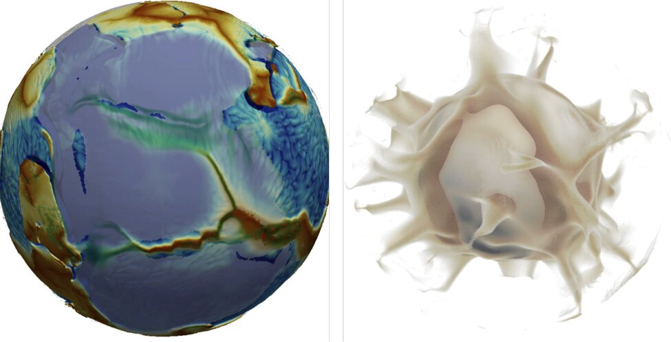
Still from a movie of simulated breakup of a supercontinent, in bland blue-grey, showing what happens at the surface (left) and, at the same time, in the mantle (right): note the influence of rising plumes (credit: Nicolas Coltice)
The result is a remarkable series of unfolding scenarios. In them, 2/3 of the planet’s surface moves faster than does the underlying mantle, suggesting that the surface is dragging the interior. For the remainder, mantle motions exceed those of the surface. Continents are dragged by the underlying mantle to aggregate in supercontinents, which in turn are torn apart by the sinking of cold oceanic slabs. The model takes on a highly visual form, showing in 3-D, for instance: ocean closure and supercontinent assembly; and example of continental breakup; how subduction is initiated.
It will be fascinating to see the reaction of the authors’ peers to their venture, and the extent to which the technicalities of the paper are translated into a form that is suitable for teaching. My suspicion is that most Earth scientists will be happy to stay with the old conceptions until the latter is achieved, and laptops are able to run the model(!)
The essence of plate tectonics that dominates the Earth system today is the existence of subduction zones that carry old, cold oceanic lithosphere to great depths where they become denser by the conversion of the mineralogy of hydrated basalt to near-anhydrous eclogite. Such gravitational sinking imparts slab-pull force that is the largest contributor to surface plate motions. Unequivocally demonstrating the action of past plate tectonics is achieved from the striped magnetic patterns above yet-to-be-subducted oceanic lithosphere, the oldest being above the Jurassic remnant of the West Pacific. Beyond that geoscientists depend on a wide range of secondary evidence that suggest the drifting and collision of continents and island arcs, backed up by palaeomagnetic pole positions for various terranes that give some idea of the directions and magnitudes of horizontal motions.
Occasionally – the more so further back in time – metamorphic rocks (eclogites and blueschists) are found in linear belts at the surface, which show clear signs of low-temperature, high pressure metamorphism that created the density contrast necessary for subduction. Where such low T/P belts are paired with those in which the effects of high T/P metamorphism occurred they suggest distinctly different geothermal conditions: low T/P associated with the site of subduction of cold rock; high T/P with a zone of magmagenesis – at island- or continental arcs – induced by crustal thickening and flux of volatiles above deeper subduction. Such evidence of geothermal polarity suggests a destructive plate margin and also the direction of relative plate motions. The oldest known eclogites (~2.1 Ga) occur in the Democratic Republic of the Congo, but do they indicate the start of modern-style plate tectonics?
Interestingly, ‘data mining’ and the use of statistic may provide another approach to this question. Determination of the temperatures and pressures at which metamorphic rocks formed using the mineral assemblages in them and the partitioning of elements between various mineral pairs has built up a large database that spans the last 4 billion years of Earth history. Plotting each sample’s recorded pressure against temperature shows the T/P conditions relative to the thermal gradients under which their metamorphism took place. Robert Holder of Johns Hopkins University and colleagues from the USA, Australia and China used 564 such points to investigate the duration of paired metamorphism (Holder, R.M. et al. 2019. Metamorphism and the evolution of plate tectonics. Nature, v. 572, p. 378–381; DOI: 10.1038/s41586-019-1462-2).
The 109 samples from Jurassic and younger metamorphosed terranes that demonstrably formed in arc- and subduction settings form a benchmark against which samples from times devoid of primary evidence for tectonic style can be judged. The post-200 Ma data show a clear bimodal distribution in a histogram plot of frequency against thermal gradient, with peaks either side of a thermal gradient of 500°C GPa-1 (~17°C km-1); what one would expect for paired metamorphic belts. A simple bell-shaped or Gaussian distribution of temperatures would be expected from metamorphism under a similar geothermal gradient irrespective of tectonic setting.
Pressure-temperature data from Jurassic and younger metamorphic rocks (a) pressure vs temperature plot; (b) Frequency distribution vs log thermal gradient. (Credit: Holder et al. 2019, Fig. 1)
Applying this approach to metamorphic rocks dated between 200 to 850 Ma; 850 to 1400 Ma; 1400 to 2200 Ma, and those older than 2200 Ma, Holder and colleagues found that the degree of bimodality decreased with age. Before 2200 Ma barely any samples fell outside a Gaussian distribution. Also, the average T/P of metamorphism decreased from the Palaeoproterozoic to the present. They interpret the trend towards increased bimodality and decreasing average T/P as an indicator that the Earth’s modern plate-tectonic regime has developed gradually since the end of the Archaean Eon (2500 Ma). Their findings also tally with the 2.1 Ga age of the oldest eclogites in the DRC.
Plate tectonics is primarily defined as the interaction between slabs of lithosphere that are rigid and brittle and move laterally above the ductile asthenosphere. Their motion rests metaphorically on the principle that ‘what comes up’ – mantle-derived magma – ‘must go down’ in the form of displaced older material that the mantle resorbs. That is more likely to be oceanic lithosphere whose bulk density is greater than that supporting the thick, low-density continental crust. Without the steeper subduction and slab pull conferred by the transformation of hydrated basalt to much denser eclogite, subduction would not result in low T/P metamorphism paired with that resulting from high T/P conditions in magmatic arcs. But, while ever lithosphere was rigid and brittle, plate tectonics would operate, albeit in forms different from that which formned terranes younger than the Jurassic
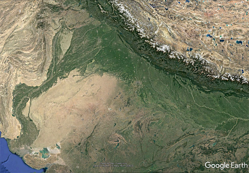
Active sedimentation in the Indus and Upper Ganges plains (green vegetated) derived from rapid erosion of the Himalaya (credit: Google Earth)
The Proterozoic Eon of the Precambrian is subdivided into the Palaeo-, Meso- and Neoproterozoic Eras that are, respectively, 900, 600 and 450 Ma long. The degree to which geoscientists are sufficiently interested in rocks within such time spans is roughly proportional to the number of publications whose title includes their name. Searching the ISI Web of Knowledge using this parameter yields 2000, 840 and 2700 hits in the last two complete decades, that is 2.2, 1.4 and 6.0 hits per million years, respectively. Clearly there is less interest in the early part of the Proterozoic. Perhaps that is due to there being smaller areas over which they are exposed, or maybe simply because what those rocks show is inherently less interesting than those of the Neoproterozoic. The Neoproterozoic is stuffed with fascinating topics: the appearance of large-bodied life forms; three Snowball Earth episodes; and a great deal of tectonic activity, including the Pan-African orogeny. The time that precedes it isn’t so gripping: it is widely known as the ‘boring billion’ – coined by the late Martin Brazier – from about 1.75 to 0.75 Ga. The Palaeoproterozoic draws attention by encompassing the ‘Great Oxygenation Event’ around 2.4 Ga, the massive deposition of banded iron formations up to 1.8 Ga, its own Snowball Earth, emergence of the eukaryotes and several orogenies. The Mesoproterozoic witnesses one orogeny, the formation of a supercontinent (Rodinia) and even has its own petroleum potential (93 billion barrels in place in Australia’s Beetaloo Basin. So it does have its high points, but not a lot. Although data are more scanty than for the Phanerozoic Eon, during the Mesoproterozoic the Earth’s magnetic field was much steadier than in later times. That suggests that motions in the core were in a ‘steady state’, and possibly in the mantle as well. The latter is borne out by the lower pace of tectonics in the Mesoproterozoic. Continue reading “The effect of surface processes on tectonics”→
Robert Stern of the University of Texas at Dallas, USA, and Taras Gerya of ETH, Zurich, have produced a masterly review of how subduction gets started from place to place, and from time to time in geological history (Stern, R.J. & Gerya, T. 2018. Subduction initiation in nature and models: A review. Tectonophysics, v. 744 (in press); (PDF). It is the foundering of oceanic lithosphere into the mantle and gravity that give modern plate tectonics the bulk of energy that drives it along by slab pull. Yet the mantle’s consumption of a lithospheric slab somehow has to be set in motion from the symmetrical spreading of ocean floor as occurs either side of a constructive margin. It could not happen were the lithosphere to retain its low bulk density relative to mantle peridotite for all time. Moreover, it wouldn’t last for long were the lithosphere not to retain its strength through hundreds of kilometres depth as it sinks into the mantle. Active subduction zones have consumed vast amounts of oceanic lithosphere, for more than 65 million years, especially in fast-spreading ocean basins such as the western and eastern Pacific. The record is held by the destructive margin on the west flank of South America where more than 150 million years-worth of eastern Pacific lithosphere has been swallowed. Yet in order for oceanic lithosphere, which is stronger than that beneath the continents, somehow to fail and begin to sink a linear weak zone must develop at the interface between two incipient new plates. On top of that, all subduction on Earth is one-sided. A simple mechanism involving just thermal convection predicts that both plates either side of a break would have similar density so both should sink, more or less symmetrically.
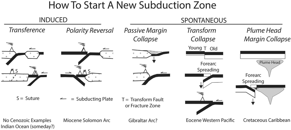
Various ways in which subduction may start. (Credit: Stern and Gerya 2018 – in press – Figure 4)
Geophysical observations reveal that terrestrial subduction can be divided into that which is induced by plate motions and changes in force balance within spreading plates, or spontaneously due to unique conditions developing along the line of initiation. In the first class are cases where a microcontinent is driven into another continental margin and extinguishes the subduction responsible, while spreading continues behind the accreted microcontinent drive older lithosphere beneath the suture (this may have happened in the past but is not seen today). Another, similar, induced case occurs where an oceanic island arc accretes by subduction beneath it so that subduction flips in polarity to consume the driving sea-floor spreading. The loading of oceanic lithosphere by sediments piled onto it by erosion of a continental margin may spontaneously collapse to result in subduction beneath the sedimentary wedge and the continent (again, not happening today, but inferred from examples inferred by earlier geological history). Spontaneous failure may also occur where old, cold lithosphere is juxtaposed with younger by transform faulting, or where a mantle plume heats up lithosphere to create a thermally weakened zone.
Stern and Gerya do not leave the issue at simple mechanics but discuss how plates may develop weak zones or inherit them from earlier tectonic events. The role of water released by metamorphism of descending materials may encourage the observed one-sidedness of subduction by reducing frictional resistance and plate strength and make the process self-sustaining. The paper also discusses the various permutations and combinations that affect the style of induced destructive margins in compressional and extensional environments and a whole variety of nuanced cases of spontaneous initiation. Numerical modelling of the subduction process plays an important, though somewhat bewildering role in discussion, as do considerations of the forces likely to be at play. Applying theoretical considerations to actual examples from the geological record are sublimely enlivening, as are speculations about the future evolution of the passive margins of the Atlantic. Clearly, there is a healthy future for field and mathematical study on the processes at destructive plate margins, such as building in the aspects of magmagenesis. Since Stern has built his career on study of long dead collusions zones, products of arc accretion etcetera, development of their understanding is undoubtedly the main thrust of his and Gerya’s tour de force. Stern provides a full PDF at his University of Texas website for the benefit of anyone who wants to delve deeper than space at Earth-pages and my limited intellect permit!
A fully revised edition of Steve Drury’s book Stepping Stones: The Making of Our Home World can now be downloaded as a free eBook
The Snowball Earth hypothesis first arose when Antarctic explorer Douglas Mawson (1882-1958)speculated towards the end of his career on an episode of global glaciations, based on his recognition in South Australia of thick Neoproterozoic glacial sediments. Further discoveries on every continent, together with precise dating and palaeomagnetic indications of the latitude at which they were laid down, have steadily concretised Mawson’s musings. It is now generally accepted that frigid conditions enveloped the globe at least twice – the Sturtian (~715 to 660 Ma) and Marinoan (650 to 635 Ma) glacial episodes – and perhaps more often during the Neoproterozoic Era. Such an astonishing idea has spurred intensive studies of geochemistry associated with the events, which showed rapid variations in carbon isotopes in ancient seawater, linked to the terrestrial carbon cycle that involves both life- and Earth processes. Strontium isotopes suggest that the Neoproterozoic launched erratic variation of continental erosion and weathering and related carbon sequestration that underpinned major climate changes in the succeeding Phanerozoic Eon. Increased marine phosphorus deposition and a change in sulfur isotopes indicate substantial change in the role of oxygen in seawater. The preceding part of the Proterozoic Eon is relatively featureless in most respects and is known to some geoscientists as the ‘Boring Billion’.
Artist’s impression of the glacial maximum of a Snowball Earth event (Source: NASA)
Noted tectonician Robert Stern and his colleague Nathan Miller, both of the University of Texas, USA, have produced a well- argued and -documented case (and probably cause for controversy) that suggests a fundamental change in the way the Precambrian Earth worked at the outset of the Neoproterozoic (Stern, R.J. & Miller, N.R. 2018. Did the transition to plate tectonics cause Neoproterozoic Snowball Earth. Terra Nova, v. 30, p. 87-94). To the geochemical and climatic changes they have added evidence from a host of upheavals in tectonics. Ophiolites and high-pressure, low-temperature metamorphic rocks, including those produced deep in the mantle, are direct indicators of plate tectonics and subduction. Both make their first, uncontested appearance in the Neoproterozoic. Stern and Miller ask the obvious question; Was this the start of plate tectonics? Most geologists would put this back to at least the end of the Archaean Eon (2,500 Ma) and some much earlier, hence the likelihood of some dispute with their views.
They consider the quiescent billion years (1,800 to 800 Ma) before all this upheaval to be evidence of a period of stagnant ‘lid tectonics’, despite the Rodinia supercontinent having been assembled in the latter part of the ‘Boring Billion’, although little convincing evidence has emerged to suggest it was an entity formed by plate tectonics driven by subduction. But how could the onset of subduction-driven tectonics have triggered Snowball Earth? An early explanation was that the Earth’s spin axis was much more tilted in the Neoproterozoic than it is at present (~23°). High obliquity could lead to extreme variability of seasons, particularly in the tropics. A major shift in axial tilt requires a redistribution of mass within a planetary body, leading to true polar wander, as opposed to the apparent polar wander that results from continental drift. There is evidence for such an episode around the time of Rodinia break-up at 800 Ma that others have suggested stemmed from the formation of a mantle superplume beneath the supercontinent.
Considering seventeen possible geodynamic, oceanographic and biotic causes that have been plausibly suggested for global glaciation Stern and Miller link all but one to a Neoproterozoic transition from lid- to plate tectonics. Readers may wish to examine the authors’ reasoning to make up their own minds – their paper is available for free download as a PDF from the publishers.
A fully revised edition of Steve Drury’s book Stepping Stones: The Making of Our Home World can now be downloaded as a free eBook
Around 63 Ma ago, during the Palaeocene Epoch, major igneous activity broke out in what are now both sides of the North Atlantic Ocean. After initial sputtering it culminated massively between 57 and 53 Ma. Relics are to be seen in Baffin Island, West and East Greenland, the Faeroes and north-western parts of the British Islands, in the form of flood basalts, dyke swarms and scattered remnants of central volcanoes. Offshore drilling on the North Atlantic’s continental shelves suggests that the volcanism extended over 1.3 million km2 and blurted out around 6.6 million km3 of magma. Not for nothing have the products of this event been categorised as a Large Igneous Province. Its formation took place before the North Atlantic existed. It began to form as this precursor magmatic paroxysm waned. Continued basaltic magma production created the ocean floor each side of the mid-Atlantic Ridge system to divide North America and Greenland from northern Europe. Sea floor spreading continues, rising above sea level in Iceland, which is underlain by a large mantle plume.
The plume beneath Iceland may have been present at a fixed position in the mantle for tens of million years. A hot spot over which plate movements have shifted lithosphere to be heated in a similar way to a sheet of paper dragged slowly over a candle flame. The Iceland plume may have left a hot-spot track similar to that involved in the Hawaiian island chain. The ocean floor to the east and west of Iceland is shallower and forms broad rides at right angles to the trend of the Mid-Atlantic Ridge system, judged to be such tracks that are still warm and buoyant after formation over the plume. But are there traces of earlier passage of drifting lithosphere over the plume. A way to detect older hot-spot tracks is through variations in geothermal heat flow through the continental surface, a linear pattern raising suspicions of such trace of passage. There is no sign to the east beneath Europe, so what about to the west. Greenland, being mainly blanketed in ice, is not a good place to conduct such a search as it would involve deep drilling through the ice at huge cost for each hole. But there is a roundabout way of obtaining geothermal information without even setting foot on Greenland’s icy wastes.
The geomagnetic field measured at the surface records anomalies in rock magnetisation in the solid Earth beneath. Near-surface variations due to large variations in rock types that comprise the continental crust appear as sharp, high frequency signals. Aeromagnetic surveys over Greenland are characterised by such noisy patterns because the subsurface geology is extremely complicated. However, the underlying upper mantle beneath all continents is geologically quite bland, but being uniformly rich in iron it contains a high proportion of magnetic minerals such as magnetite (Fe3O4). The upper mantle should therefore leave a signal in the surface geomagnetic field, albeit a commensurately bland one. Like radio signals that span a large range of wavelengths, Earth properties that vary spatially, such as the geomagnetic field, may be analysed using filters. Once the high-frequency geomagnetic features of the crust are filtered out what should remain is a signal that reflects the magnetic structure of the upper mantle. It should be more or less featureless, yet beneath Greenland it isn’t.
Estimated Curie depth variation below Greenland (left) converted to geothermal heat flow variation (right). (Credit: Martos et al. 2018; Figures 1b and 1c)
Magnetic anomalies are created by magnetisation induced in magnetic minerals in rocks by the Earth’s magnetic field. Yet minerals lose their ability to be magnetised at temperatures above a threshold known as the Curie point, which is 580 °C for magnetite, the most abundant magnetic mineral. Depending on the geothermal heat flow the Curie point is exceeded at some depth in the lithosphere. So magnetic anomalies can safely be assumed to be produced only by rocks above the so-called Curie depth. Yasmina Martos of the British Antarctic Survey (now at the University of Maryland) and scientists from Britain, the US and Spain used a complex procedure, including gravity data and a few direct measurements of heat flow below Greenland as well as filtered aeromagnetic data, to estimate the variation in Curie depth beneath the ice cap. (Martos, Y.M. et al. 2018. Geothermal heat flux reveals the Iceland hotspot track underneath Greenland. Geophysical Research Letters, v. 45, online publication; doi: 10.1029/2018GL078289). Using that as an inverse proxy for heat flow they were able to map the likely geothermal variation beneath the island. Rather than a random and narrow variation in depth, as would be expected for roughly uniform heat flow, the Curie depth varied in a non-random way by over 20 km, equivalent to roughly 20 mW m-2.
The shallowest Curie depth and highest estimated heat flow occurs in East Greenland around Scoresby Sund where the largest sequence of Palaeocene flood basalts occur. It is also on a line perpendicular to the mid-Atlantic Rift system that meets the active Iceland plume. Running north-west from Scoresby Sund is a zone of locally high estimated heat flow. Martos et al. suggest that this is the track of Greenland’s motion over the Iceland hot spot from about 80 Ma to the period of maximum on-shore volcanism and the start of sea-floor spreading at around 50 Ma.
A fully revised edition of Steve Drury’s book Stepping Stones: The Making of Our Home World can now be downloaded as a free eBook
Because continental crust is so light – an average density of 2700 kg m-3 compared with the mantles’ value of 3300 – it has been widely believed that continents cannot be subducted en masse. Yet it is conceivable that sial can be ‘shaved’ from below during subduction and from above by erosion and added to subductable sediment on the ocean floor. Certainly, there is overwhelming evidence for the net growth of continents through time and plenty for periods of increased and dwindling growth in the past. In some ancient orogens there are substantial slabs of continental composition whose mineralogy bears witness to ultra-high pressure metamorphism at depths greater than that of the base of continents. These slabs had been caught-up in subduction but never reached sufficiently high density to be retained by the mantle; they eventually ‘bobbed up’ again. On the other hand, if early continents were less silica rich through incorporation of substantial proportions of rock with basaltic composition parts of them could founder if subjected to high-pressure, low-temperature metamorphism. But not all crustal recycling to the mantle is through subduction. Some abnormally highly elevated parts of the continents that rose quickly in geological terms, such as the Tibetan Plateau, may have formed by lower crustal slabs becoming detached or delaminated from their base. Again modelling can help assess the past magnitude of continental recycling (Chowdhury, P. et al. 2017. Emergence of silicic continents as the lower crust peels off on a hot plate-tectonic Earth. Nature Geoscience, v. 10, p. 698-703; DOI: 10.1038/NGEO3010).
Various lines of evidence suggest that between 65 to 70% of the present continental volume existed by 3 billion years ago, yet that does not manifest itself in the rock record; perhaps a sign that some has returned to the mantle. It is also widely suggested that plate tectonics in the modern style began at about that time. Pryadarshi Chowdhury and colleagues simulate what may happen at depth in continent-continent collision zones – the classic site of orogenies –at different times in the past. Under the hotter conditions in the early Archaean mantle delamination would have been more likely than it has been during the Phanerozoic; i.e. the peeling off and sinking of the denser, more mafic lower crust and the attached upper mantle. The authors show that increased mantle temperature further back in time increases the likelihood and extent of such delamination. It also encourages partial melting of the descending continental material so creating rising bodies of more silicic magma that add to the remaining continent at the surface. Together with the lower crust’s attachment of to a mantle slab, this ensures that the peeled off material is able to descend under its own load. Once below a depth of 250 km felsic rocks are doomed to further descent. Waning of radiogenic mantle heat production encourages descending slabs to fail and break from the connection with lithosphere at higher levels so that a smaller proportion of the lower crust becomes detached and recycled. This evolution suggests that less and less continental crust is recycled with time. This broadly fits with current geochemical ideas based on the record of radiogenic Nd-, Sr- and Pb-isotopes in rocks ranging from early Archaean to Phanerozoic age.
As DNA is to tracing human evolution and migration, so various isotope systems are to the evolution of the Earth. One of the most fruitful is the samarium-neodymium (Sm-Nd) system. The decay of 147Sm to 143Nd is used in dating rocks across the full range of Earth history, given coeval rocks with a suitable range of Sm/Nd ratios, because the decay has a long half life (1.06 x 10¹¹ years). However, samarium has another radioactive isotope 147Sm with a half life that is a thousand times shorter (1.06 x 10⁸ years). So it remains only as a minute proportion of the total Sm in rocks, most having decayed since it was formed in a pre-Solar System supernova. But its daughter isotope 142Nd is present in easily measurable quantities, having accumulated from 147Sm decay over the first few hundred million years of Earth’s history; i.e. during the Hadean and earliest Archaean Eons. It is this fact that allows geochemists to get an indirect ‘handle’ on events that took place in the Earth’s earliest, largely vanished history. The principle behind this approach is that when an ancient rock undergoes partial melting to produce a younger magma the rock that crystallizes from it inherits the relative proportions of Nd isotopes of its source and thereby carries a record of the earlier history.
Metamorphosed volcanosedimentary rocks from the Porpoise Cove locality, Nuvvuagittuq supracrustal belt, Canada. Possibly the oldest rocks on Earth. (credit: Wikipedia)
The eastern shore of Hudson Bay in Canada hosts the oldest tangible geology known, in form of some metamorphosed basaltic rocks dated at 4200 Ma old known as the Nuvvuagittuq Greenstone Belt – the only known Hadean rocks. They occur in a tiny (20 km2) patch associated with gneisses of tonalite-trondjhemits-granodiorite composition that are dated between 3760 and 3350 Ma. Engulfing both are younger (2800 to 2500 Ma) Archaean plutonic igneous rocks of felsic composition. Jonathan O’Neil and Richard Carlson of the University of Ottawa, Canada and the Carnegie Institution for Science, Washington DC, USA respectively, measured proportions of Nd isotopes in both sets of felsic igneous rocks (O’Neil, J. & Carlson, R.W. 2017. Building Archean cratons from Hadean mafic crust. Science, v. 355, p. 1199-1202; doi:10.1126/science.aah3823).
The oldest gneisses contained relative proportions of 142Nd commensurate with them having been formed by partial melting of the Hadean mafic rocks about a few hundred million years after they had been erupted to form the oldest known crust; no surprise there. However, the dominant components of the local continental crust that are about a billion years younger also contain about the same relative proportions of 142Nd. A reasonable conclusion is that the Archaean continental crust of NE Canada formed by repeated melting of mafic crust of Hadean age over a period of 1.5 billion years. The modern Earth continually replenishes its oceanic crust over about 200 Ma due to plate tectonics. During the Archaean mantle dynamics would have been driven faster by much higher internal heat production. Had this involved simply faster plate tectonics the outermost skin of mafic crust would have been resorbed into the mantle even faster. By the end of the Archaean (2500 Ma) barely any Hadean crust should have been available to produce felsic magmas. But clearly at least some did linger, adding more weight to the idea that plate tectonics did not operate during the Hadean and Archaean Eons. See Formation of continents without subduction below.
As computing power and speed have grown ever more sophisticated models of dynamic phenomena have emerged, particularly those that focus on meteorology and climatology. Weather and climate models apply to the thin spherical shell that constitutes Earth’s atmosphere. They consider incoming solar radiation and longer wavelength thermal radiation emitted by the surface sources and sinks of available power, linked to the convective circulation of energy and matter, most importantly water as gas, aerosols, liquid and ice in atmosphere and oceans. Such general circulation models depend on immensely complex equations that relate to the motions of viscous media on a rotating sphere, modulated by other aspects of the outermost Earth: the absorptive and reflective properties of the materials from which it is composed – air, rocks, soils, vegetation, water in liquid, solid and gaseous forms; different means whereby energy is shifted – speeds of currents and wind, adiabatic heating and cooling, latent heat, specific heat capacity of materials and more still. The models also have to take into account the complex forms taken by circulation on account of Coriolis’ Effect, density variations in air and oceans, and the topography of land and ocean floor. The phrase ‘and much more besides’ isn’t really adequate for such an enormous turmoil, for the whole caboodle has chaotic tendencies in time as well as 3-D space. The fact that such modelling does enable weather forecasting that we can believe together with meaningful forward and backward ‘snapshots’ of overall climate depends on increasing amounts of empirical data about what is happening, where and when. Models of this kind are also increasingly able to address issues of why such and such outcomes occur, an important example being the teleconnections between major weather events around the globe and phenomena such as the El Nino-Southern Oscillation – the periodic fluctuation of ocean movements, winds and sea-surface temperatures over the tropical eastern Pacific Ocean.
The Earth’s 15 largest tectonic plates. (credit: Wikipedia)
The Earth’s lithosphere and deeper mantle in essence present much the same challenge to modellers. Silicate materials circulate convectively in a thick spherical shell so that radiogenic heat and some from core formation can escape to keep the planet in thermal balance. There are differences, the obvious ones being sheer scale and a vastly more sluggish pace, but most important are the interactions between materials with very different viscosities; the ability of the deep mantle to move by plastic deformation while the lithosphere moves as rigid, brittle plates. For geophysicists interested in modelling there are other differences; information that bears on the system is orders of magnitude less, its precision is much poorer and all of it is based on measurement of proxies. For instance, information on temperature comes from variations in seismic wave speed given by analysis of arrival times at surface observatories of different kinds of wave emitted by individual earthquakes. That is, from seismic tomography, itself a product of immensely complex computation. Temptation by computing power and the basic equations of fluid dynamics, however, has proved hard to resist and the first results of a general circulation model for the solid Earth have emerged (Mallard, C. et al. 2016. Subduction controls the distribution and fragmentation of Earth’s tectonic plates. Nature, v. 535, p. 140-143).
As the title suggests, the authors’ main objective was understanding what controls the variety of lithospheric tectonic plates, particularly how strain becomes localised at plate boundaries. They used a circulation model for an idealised planet and examined several levels of a plastic limit at which the rigidity of the lithosphere drops to localise strain. At low levels the lithosphere develops many plate boundaries, and as the plastic limit increases so the lithosphere ends up with increasingly fewer plates and eventually a rigid ‘lid’. The modelling also identified divergent and convergent margins, i.e. mid-ocean ridges and subduction zones. The splitting in two of a single plate must form two triple junctions, whose type is defined by the kinds of plate boundary that meet: ridges; subduction zones; transform faults. Both the Earth and the models show significantly more triple junctions associated with subduction than with extension, despite the fact that ridges extend further than do subduction zones. And these trench-associated triple junctions are mainly those dividing smaller plates. This suggests that it is subduction that focuses fragmentation of the lithosphere, and the degree of fragmentation is controlled by the lithosphere’s strength. There is probably a feedback between mantle convection and lithosphere strength, suggesting that an earlier, hotter Earth had more plates but operated with fewer, larger plates as it cooled to the present. But that idea is not new at all, although the modelling gives support to what was once mere conjecture.
Tiny, 4.4 billion year old zircon grains extracted from much younger sandstones in Western Australia are the oldest known relics of the Earth system. But they don’t say much about early tectonic processes. For that, substantial exposures of rock are needed, of which the undisputedly oldest are the Acasta gneisses 300 km north of Yellowknife in Canada’s North West Territories, which have an age of slightly more than 4 Ga. The ‘world’s oldest rock’ has been something of a grail for geologists and isotope geochemists who have combed the ancient Archaean cratons for 5 decades. But since the discovery of metasediments with an age of 3.8 Ga in West Greenland during the 1970s they haven’t made much headway into the huge time gap between Earth’s accretion at 4.54 Ga and the oldest known rocks (the Hadean Eon).
Continental cratons (orange) where very-old rocks are likely to lurk. (credit: Wikipedia)
There have been more vibrant research themes about the Archaean Earth system, specifically the issue of when our planet settled into its modern plate tectonic phase A sprinkling of work on reconstructing the deep structural framework of Archaean relics has convinced some that opposed motion of rigid, brittle plates was responsible for their geological architecture, whereas others have claimed signs of a more plastic and chaotic kind of deformation of the outer Earth. More effort has been devoted to using the geochemistry of all the dominant rocks found in the ancient cratons, seeking similarities with and differences from those of more recent vintage. There can be little doubt that the earliest processes did form crust whose density prevented or delayed it from being absorbed into the mantle. Even the 4.4 Ga zircons probably crystallized from magma that was felsic in composition. Once trapped by buoyancy at the surface and subsequently wrapped around by similarly low density materials continental crust formed as a more or less permanent rider on the Earth’s deeper dynamics. But did it all form by the same kinds of process that we know to be operating today?
Plate tectonics involves the perpetual creation of rigid slabs of basalt-capped oceanic lithosphere at oceanic rift systems and their motions and interactions, including those with continental crust. Ocean floor cools as it ages and becomes hydrated by seawater that enters it. The bulk of it is destined eventually to oppose, head-to-head, the motions of other such plates and to deform in some way. The main driving force for global tectonics begins when an old, cold plate does deform, breaks, bends and drives downwards. Increasing pressure on its cold, wet basaltic top transforms it into a denser form: from a wet basaltic mineralogy (feldspar+pyroxene+amphibole) to one consisting of anhydrous pyroxene and garnet (eclogite) from which watery fluid is expelled upwards. Eclogite’s density exceeds that of mantle peridotite and compels the whole slab of oceanic lithosphere to sink or subduct into the mantle, dragging the younger parts with it. This gravity-induced ‘slab pull’ sustains the sum total of all tectonic motion. The water rising from it induces the wedge of upper mantle above to melt partially, the resulting magma evolves to produce new felsic crust in island arcs whose destiny is to be plastered on to and enlarge older continental masses.
Relics of eclogites and other high-pressure, low-temperature versions of hydrated basalts incorporated into continents bear direct and unchallengeable witness to plate tectonics having operated back to about 800 Ma ago. Before that, evidence for plate tectonics is circumstantial and in need of special pleading. Adversarial to-ing and fro-ing seems to be perpetual, between geoscientists who see no reason to doubt that Earth has always behaved in this general fashion and others who see room for very different scenarios in the distant past. The non-Huttonian tendency suggests an early, more ductile phase when greater radioactive heat production in the mantle produced oceanic crust so fast that when it interacted with other slabs it was hot enough to resist metamorphic densification wherever it was forced down. Faster production of magma by the mantle without slab-pull could have produced a variety of ‘recycling’ turnover mechanisms that were not plate-tectonic.
One thing that geochemists have discovered is that the composition of Archaean continental crust is very different from that produced in later times. In 1985 Ross Taylor and Scott McLennan, then of the Australian National University, hit on the idea of using shales of different ages as proxies for the preceding continental crust from which they had been derived by long erosion. Archaean and younger shales differed in such a way that suggests that after 2.5 Ga (the end of the Archaean) vast amounts of feldspar were extracted from the continent-forming magmas. This left the later Precambrian and Phanerozoic upper crust depleted in the rare-earth element europium, which ended up in a mafic, feldspar-rich lower crust. On the other hand, no such mass fractionation had left such a signature before 2.5 Ga. Another ANU geochemist, now at the University of Maryland, Roberta Rudnick has subsequently carried this approach further, culminating in a recent paper (Tang, M., Chen, K and Rudnick, R.L. 2016. Archean upper crust transition from mafic to felsic marks the onset of plate tectonics. Science, v. 351, p. 372-375). This uses nickel, chromium and zinc concentrations in ancient igneous and sedimentary rocks to track the contribution of magnesium (the ‘ma’ in ‘mafic’) to the early continents. The authors found that between 3.0 to 2.5 Ga continental additions shifted from a dominant more mafic composition to one similar to that of later times by the end of the Archaean. Moreover, this accompanied a fivefold increase in the pace of continental growth. Such a spurt has long been suspected and widely suggested to mark to start of true plate tectonics: but an hypothesis bereft of evidence.
A better clue, in my opinion, came 30 years ago from a study of the geochemistry of actual crustal rocks that formed before and after 2.5 Ga (Martin, H. 1986. Effect of steeper Archean geothermal gradient on geochemistry of subduction-zone magmas. Geology, v. 14, p. 753-756). Martin showed that plutonic Archaean and post-Archaean felsic rocks of the continental crust lie in distinctly different fields on plots of their rare-earth element (REE) abundances. Archaean felsic plutonic rocks show a distinct trend of enrichment in light REE relative to heavy REE as measures of the degree of partial melting decreases, whereas the younger crustal rocks show almost constant, low values of heavy REE/light REE whatever the degree of melting. The conclusion he reached was that while in the post Archaean the source was consistent with modern subduction processes – i.e. partial melting of hydrated peridotite in the mantle wedge above subduction zones – but during the Archaean the source was hydrated, garnet-bearing amphibolite of basaltic composition, in the descending slab of subducted oceanic crust. Together with Taylor and McLennan’s lack of evidence for any fractional crystallization in Archaean continental growth, in contrast to that implicated in Post-Archaean times.
The geochemistry forces geologists to accept that a fundamental change took place in the generation and speed of continental growth at the end of the Archaean, marking a shift from a dominance of melting of oceanic, mafic crust to one where the upper mantle was the main source of felsic, low-density magmas. Yet, no matter how much we might speculate on indirect evidence, whether or not subduction, slab-pull and therefore plate tectonics dominated the Archaean remains an open question.
Although Alfred Wegener first began to present his ideas on Continental Drift in 1912 his publication in 1915 of The Origin of Continents and Oceans (Die Entstehung der Kontinente und Ozeane) is generally taken as the global launch of his hypothesis. Apart from support from Alexander du Toit and Arthur Holmes, geoluminaries of the day panned it unmercifully because, in the absence of evidence for a driving mechanism, he speculated that his proposed ‘urkontinent’ (primal continent) Pangaea had been split apart by a centrifugal mechanism connected to the precession of Earth’s rotational axis. This ‘polflucht’ (flight from the poles) is in fact far too weak to have any such influence. Wegener’s masterly assembly of geological evidence for former links between the major continents was ignored by the critics, suggesting that their motive for excoriation of his suggested mechanism was as much spite against an ‘outsider’ as a full consideration of his hypothesis. It must have been hurtful in the extreme, yet Wegener defended himself with a series of revised editions that amassed yet more concrete evidence. What is often overlooked, even now that his ideas have become part of the geoscientific canon, is that in his initial Geologische Rundschau paper in 1912 he mused that the floor of the Atlantic is continuously spreading by tearing apart at the mid-Atlantic Ridge where ‘relatively fluid and hot sima’ rises. Strangely, he dropped that idea in later works. Anyhow, neither 2012 nor 2015 was celebrated in the manner of the centenary-and-a-half of Darwin’s On the Origin of Species: 2009 was marked by palaeobiologists and geneticists metaphorically dancing in the streets, if not foaming at the mouth. There have been a few paragraphs, and some minor symposia about Wegener’s dragging geology out of the 18th century and into the 20th, but that’s about it. The best centenary item I have seen is by Marco Romano and Richard Cifelli (Romano, M. & Cifelli, R.L. 2015. 100 years of continental drift. Science, v. 350, p. 916-916).
In the shape of plate tectonics the Earth sciences hosted what was truly a revolution in science, albeit 50 years on from its discoverer’s announcement. It was through the persistent agitation by his tiny band of supporters, that the upheaval was unleashed when the revelations from palaeomagnetism, seismology and many other lines of evidence were resolved as plate tectonics by the discovery of ocean-floor magnetic stripes by Vine, Matthews and Morley in 1963. Despite an explosion of papers that followed, elaborating onthe new theory and showing examples of its influence on ‘big’ geology , counter-revolutionary resistance lasted almost to the first years of the new century. By then so much evidence had emerged from every geological Eon that opponents looked truly stupid. Even so, the skepticism among those sub-disciplines that were ‘left out’ of geodynamic thought continued to blurt out with the emergence of other exciting aspects of the Earth’s history. I remember that, when three of us in the Open University’s Department of Earth Sciences proposed in 1994 that the influence of impacts by extraterrestrial objects ought to figure in a new course on the evolution of Earth and Life we were sneered at as ‘whizz-bang kids’ by those more earth-bound. Trying belatedly in 1996 to introduce students to another revolutionary development – the use of sedimentary and glacial oxygen isotopes in unraveling past climate change – became a huge struggle in the OU’s Faculty of Science. It went to the press eventually and for 2 years our students had the benefit. But the murmuration of dissent ended with a force-majeur re-edit of the course, by someone who had played no role in its development, expunged the lot and changed the ‘offending’ section back to the way it had been a decade before. As they say: ho hum!
Oddly, in the last 15 years or so of trying to follow in Earth-Pages what I considered to be the most exciting developments in the geosciences, it has become increasing difficult to find papers in the top journals that are truly ground-breaking. Of course that may just be ageing and a certain cynicism that often companies it. From being spoiled for choice week after week it has become increasingly difficult from month to month to maintain the standards that I have set for new work. Has Earth science entered the fifth phase of a ‘paradigm shift’ predicted by philosopher Thomas Kuhn in his 1962 book The Structure of Scientific Revolutions? According to him once a science has entered a period when there is little consensus on the theories that might lie at the root of natural processes there is a drift in opinion to a few conceptual frameworks that seem to work, albeit leaving a lot to be desired. Weaknesses at the frontier between theory and empirical knowledge become increasingly burdensome as a result of the steady plod of ‘normal science’ until the science in question reaches a crisis. If existing paradigms fail repeatedly, science is ripe for the metaphorical equivalent of a ‘Big Bang’: maybe an entirely new discovery or hypothesis, or an idea that has been suppressed which new data fits better than any others that have been common currency. Plate Tectonics is the second kind. After the revolution much is reexamined and new lines of work emerge, until in Kuhn’s 5th phase scientists return to ‘normal science’. That looks like a pretty good story, on paper, but other forces are at work in science; external to scientific objectives. Most of these are a blend of economics, political ideologies and managerial ‘practicalities’. If the Earth sciences have entered the doldrums of novelty, I suspect it is these forces that are bearing some kind of glum fruit.
The old concept of academic freedom has gone by the board. Institutions demand that research is externally funded – the more the better as the institution, at least in the UK, demands a kind of tax (40% of that proposed) supposedly to cover corporate overheads including salaries of support staff. If an academic doesn’t pull in the dosh, she is not much favoured. If the individual doesn’t publish regularly either, there is a weasel sanction: Josephine Soap is declared ‘research inactive’. Consortia of researchers are more and more in vogue: managers and funders like ‘team players’, so individuals who are bright and confident enough to ‘stick their necks out’ cannot do that in a consortium publication and as often as not are ‘left on the bench’. Risk taking is more dangerous now and to stay ‘research active’, and in many cases of non-tenured posts getting a salary, an individual, even a few like-minded colleagues have to publish 2 or 3 papers a year.
It’s worth mentioning that open access publishing is not just all the rage, it has become more or less compulsory. Of course, it has some benefits for scientists in less well-heeled countries, but there is a downside. You have to raise the cash demanded by journals for the privilege or potentially universal access – at least US$1000 a pop, depending on a journals Impact Factor, and that of course is an odiously essential corporate consideration – and having done that woe betide those who do not publish and spend it. Academic publishing is the most profitable sector of the trade, the more so as print is supplanted by electronic delivery – the 50 free reprints is a thing of the past. So there are more and more journals and each of them strives to get out more issues per year, and of course those have to be filled. To me, this all adds up to more and more ‘pot-boiler’ articles and a tendency to maximise the flesh rendered from the body of research work and into the pot. Taken together with the stresses of commodification in higher education and the now vertical corporate structures from which it is constituted, it shouldn’t be a surprise that excitement and inspiration are at a premium in the weekly and monthly output of such a marginal science as that concerned with how the world works.
Although no one can be sure about the details of processes in the Earth’s core what is accepted by all is that changes in core dynamics cause the geomagnetic field to change in strength and polarity, probably through some kind of physical interaction between core and deep mantle at the core-mantle boundary (CMB). Throughout the last 73 Ma and especially during the Cenozoic Era geomagnetism has been more fickle than at any time since a more or less continuous record began to be preserved in the Jurassic to Recent magnetic ‘stripes’ of the world ocean floor. Moreover, they came in bursts: 5 in a million years at around 72 Ma; 10 in 4 Ma centred on 54 Ma; 17 over 3 Ma around 42 Ma; 13 in 3 Ma at ~24 Ma; 51 over a period of 12 Ma centring on 15 Ma. During the Late Jurassic and Early Cretaceous the core was similarly ‘busy’, the two time spans of frequent reversals being preceded by quiet ‘superchrons’ dominated by the same normal polarity as we have today i.e. magnetic north being roughly around the north geographic pole.
The Cenozoic history of magnetic reversals – black periods were when geomagnetic field polarity was normal and white when reversed. (credit: Wikipedia)
Until recently geomagnetic ‘flips’ between the two superchrons were regarded as random , perhaps suggesting chaotic behaviour at the CMB. But such a view depends on the statistical method used. A novel approach to calculating reversal frequency through time, however, shows peak-trough pairs recurring 5 times through the Cenozoic Era, approximately 13 Ma apart: maybe the chaos is illusory (Chane, J. et al. 2015. The 13 million year Cenozoic pulse of the Earth. Earth and Planetary Science Letters, v. 431, p. 256-263). So, here is a kind of yardstick to see if there may be any connection between core processes and those at the surface, which Chen of the Fujian Normal University, Fushou China and Canadian and Chinese colleagues compared with the very detailed Cenozoic oxygen-isotope (δ18O) record preserved by foraminifera in ocean-floor sediments, which is a well established proxy for changes in climate. Removing the broad trend of cooling through the Cenozoic resulted in a plot of more intricate climatic shifts that matches the geomagnetism record in both shape and timing of peak-trough pairs. It also turns out, or so the authors claim, that both measures correlate with changes in the rate of Cenozoic subduction of oceanic lithosphere (a measure of plate tectonic activity), albeit negative – peaks in magnetism and climate connecting with slowing in the pace of tectonics.
The analyses involved some complicated maths, but taken at face value the correlations beg the questions why and how? Long-term climate change contains an astronomical signal, encapsulated in the Milankovich hypothesis which has been tested again and again with little room for refutation. So is this all to do with gravitational influences in the Solar System. More exotic still is the possibility of 13 Ma cyclicity linking the Milankovich mechanism with the vaster scale of the Sun’s orbit oscillating through the disc of the Milky Way galaxy and theoretical hints of a mysterious role for dark matter in or near the galaxy. Or, is it a relationship in which climate and the magnetic field are modulated by plate tectonics through varying volcanic emissions of greenhouse gases and the deep effect of subduction on processes at the CMB respectively? To me that seems more plausible, but it is still as exceedingly complex as the maths used to reveal the correlations.
One of the pioneers of plate tectonics, W. Jason Morgan, recognised in the 1970s that chains of volcanic islands and seamounts that rise from the ocean floor may have formed as the movement of lithospheric plates passed over sources of magma that lay in the mantle beneath the plates. He suggested that such hotspots were fixed relative to plate movements at the surface and likened the formation of chains such as that to the west of the volcanically active of the Hawaiian ‘Big Island’ to linear scorching of a sheet of paper moved over a candle flame. If true, it should be possible to use hotspots as a framework for the absolute motion of lithospheric plates rather than the velocities of individual plates relative to the others. But Morgan’s hypothesis has been debated ever since he formulated it. A test would be to see whether or not plumes of rising hot material in the deep part of the mantle can be detected. This became one of the first objectives of seismic tomography when it was devised in the last decade of the 20th century: a method that uses global earthquakes records to detect parts of the mantle where seismic waves traveled faster or slower than the norm: effectively patches of hot (probably rising) and cold rock. The first such evidence was equally hotly debated, one view being that the magma sources beneath oceanic islands such as Hawaii and Iceland were actually related to plate tectonics and that the hotspot hypothesis had become a kind of belief system.
Global distribution of hotspots ( credit: Wikipedia)
The problem was that mantle plumes supposedly linked to magmatic hotspots in the upper mantle would be so thin that they would be difficult to detect even with seismic tomography. Geophysicists have been trying to sharpen up seismic resolution partly by using supercomputers to analyse more and more seismic records and also by improving the theory about how seismic waves interact with 3-D mantle structure. This has culminated in more believable visualisation of mantle structure (French, S.W. & Romanowicz, B. 2015. Broad plumes rooted at the base of the Earth’s mantle beneath major hotspots). The two researchers from the University of California at Berkeley in fact showed something different, but still robust support for Morgan’s 40-year old ideas. Instead of thin plumes, they have been able to show much broader conduits beneath at least 5 and maybe more active ends of hotspot chains. The zones extend upwards from the core-mantle boundary to about 1000 km below the Earth’s surface, where some bend sideways towards hotspots, perhaps as a result of another kind of upper mantle circulation.
The sources of these hot columns at the core-mantle boundary appear to be zones of very low shear-wave velocities; i.e. almost, but not quite molten blobs. French and Romanowicz suggest that the columns are extremely long-lived and may even have a chemical dimension – as in the hypothesis of mantle heterogeneity. Another interesting feature of their results is that the striking vertical linearity of the columns could indicate that the overall motion of the lower mantle is extremely sluggish and punctured by discrete convection.
By far the least costly means of surveying the ocean floor on a global scale is the use of data remotely sensed from Earth orbit. That may sound absurd: how can it be possible to peer through thousands of metres of seawater? The answer comes from a practical application of lateral thinking. As well as being influenced by lunar and solar tidal attraction, sea level also depends on the Earth’s gravity field; that is, on the distribution of mass beneath the sea surface – how deep the water is and on varying density of rocks that lie beneath the sea floor. Water having a low density, the deeper it is the lower the overall gravitational attraction, and vice versa. Consequently, seawater is attracted towards shallower areas, standing high over, say, a seamount and low over the abyssal plains and trenches. Measuring sea-surface elevation defines the true shape that Earth would take if the entire surface was covered by water – the geoid – and is both a key to variations in gravity over the oceans and to bathymetry.
Radar altimeters can measure the average height of the sea surface to within a couple of centimetres: the roughness and tidal fluctuations are ‘ironed out’ by measurements every couple of weeks as the satellite passes on a regular orbital schedule. There is absolutely no way this systematic and highly accurate approach could be achieved by ship-borne bathymetric or gravity measurements, although such surveys help check the results from radar altimetry over widely spaced transects. Even after 40 years of accurate mapping with hundreds of ship-borne echo sounders 50% of the ocean floor is more than 10 km from such a depth measurement (80% lacks depth soundings)
This approach has been used since the first radar altimeter was placed in orbit on Seasat, launched in 1978, which revolutionised bathymetry and the details of plate tectonic features on the ocean floor. Since then, improvements in measurements of sea-surface elevation and the computer processing needed to extract the information from complex radar data have show more detail. The latest refinement stems from two satellites, NASA’s Jason-1(2001) and the European Space Agency’s Cryosat-2 (2010) (Sandwell, D.T. et al. 2014. New global marine gravity model from CryoSat-2 and Jason-1 reveals buried tectonic structure. Science, v. 346. p. 65-67; see also Hwang, C & Chang, E.T.Y. 2014. Seafloor secrets revealed. Science, v. 346. p. 32-33). If you have Google Earth you can view the marine gravity data by clicking here. The maps throw light on previously unknown tectonic features beneath the China Sea (large faults buried by sediments), the Gulf of Mexico (an extinct spreading centre) and the South Atlantic (a major propagating rift) as well as thousands of seamounts.
Global gravity over the oceans derived from Jason-1 and Cryosat-2 radar altimetry (credit: Scripps Institution of Oceanography)
There are many ways of processing the data, and so years of fruitful interpretation lie ahead of oceanographers and tectonicians, with more data likely from other suitably equipped satellites: sea-surface height studies are also essential in mapping changing surface currents, variations in water density and salinity, sea-ice thickness, eddies, superswells and changes due to processes linked to El Niño.