The last known Homo erectus

There are a lot of assumptions made about Homo erectus and, indeed, there is much confusion surrounding the species (see: various items in Human evolution and migrations logs for 2001, 2002, 2003 and several other years). For a start, the name derives from Eugene Dubois’s 1891 discovery of several hominin cranial fragments in sediments deposited by the Solo River in Java. Dubois was the first to recognise in ‘Java Man’ the human-ape ‘missing link’ about which Charles Darwin speculated in his The Descent of Man, and Selection in Relation to Sex (1871). Dubois named the beings Pithecanthropus (now Homo) erectus. Once the “multiregional” versus “out-of-Africa” debate about the origin of anatomically modern humans (AMH) emerged after a variety of H. erectus-like fossils had also turned up in Africa and Europe, as well as in East and SE Asia, ‘Java Man’ was adopted by the multiregionalists as ‘evidence’ for separate evolution of AMH in Asia. Such a view remains adhered to by a tenacious number of Chinese palaeoanthropologists, but by virtually no-one else.

Reconstruction of the Nariokotome Boy from the skeleton found in the Turkana Basin of Kenya (credit: Atelier Daynes/Science Photo Library)

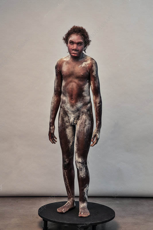
The earliest of the African ‘erects’ were distinguished as H. ergaster, represented by the 1.6 Ma old, almost intact skeleton of Nariokotome Boy from the Turkana area of Kenya. In Africa the specific names ergaster and erectus often seem to be used as synonyms, whereas similar-looking fossils from Asia are almost always referred to as ‘Asian ­H. erectus’. Matters became even more confusing when the earliest human migrants from Africa to Eurasia were discovered at Dmanisi in Georgia (see; Human evolution and migrations logs for 2002, 2003, 2007, 2013). Anatomically they deviate substantially from both H. ergaster and Asian erectus – and from each other! – and at 1.8 Ma they are very old indeed. Perhaps as a palliative in the academic rows that broke out following their discovery, for the moment they are called Homo erectus georgicus; a sub-species. But, then, how can Asian H. erectus be regarded as their descendants. Yet anatomically erectus-like fossils are known in East and SE Asia from 1.5 Ma onwards.

There is another mystery. Homo ergaster/erectus in Africa made distinctive tools, typified by the bifacial Acheulian hand axe. Their tool kit remained substantially the same for more than a million years, and was inherited by all the descendants of H. erectus in Africa and Europe: by H. antecessor, heidelbergensis, Neanderthals and early AMH. Yet in Asia, such a technology has not been discovered at sites older than around 250 thousand years. Either no earlier human migrants into Asia made and carried such artefacts or stone tools were largely abandoned by early Asian humans in favour of those more easily made from woods, for instance bamboo.

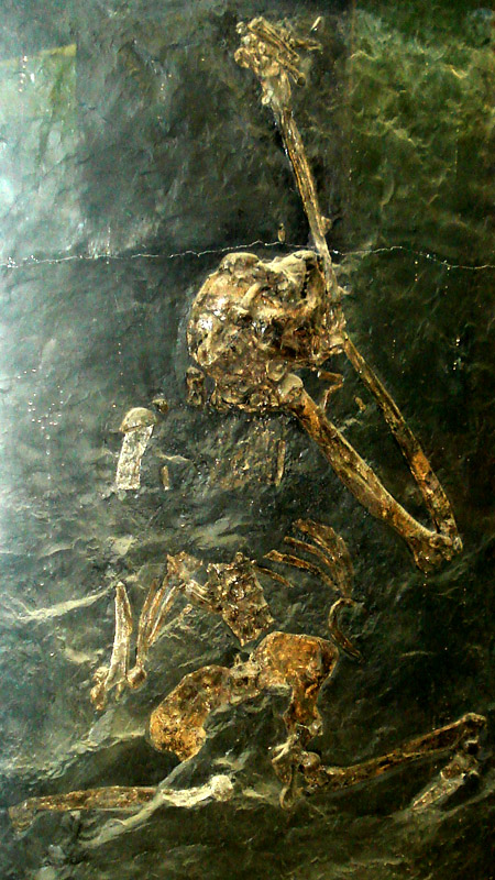
In 1996 the youngest Solo River sediments that had yielded H. erectus remains in the 1930s were dated using electron-spin resonance and uranium-series methods. The results suggested occupation by ‘erects’ between 53 and 27 ka, triggering yet more astonishment, because fully modern humans had by then also arrived in Indonesia. Could anatomically modern humans have co-existed with a species whose origin went back to almost two million years beforehand? It has taken another two decades for this perplexing issue to be clarified – to some extent. The previous dates were checked using more precise versions of the original geochronological methods covering a wider range of sediment strata (Rizal, Y. et al. 2019. Last appearance of Homo erectus at Ngandong, Java, 117,000–108,000 years ago. Nature, published online; DOI:10.1038/s41586-019-1863-2). No AMH presence in Asia is known before about 80 ka, so can the astonishment be set aside? Possibly, but what is known for sure from modern and ancient DNA comparisons is that early modern human migrants interbred with a more ancient Asian group, the Denisovans. At present that group is only known from a site in Siberia and another in Tibet through a finger bone and a few molar teeth that yielded DNA significantly different from both living humans and ancient Neanderthals. So we have no tangible evidence of what the Denisovans looked like, unlike Asian H. erectus of whom there are many substantial fossils. Yet DNA has not been extracted from any of them. That is hardly surprising for the Indonesian specimens because hot and humid conditions cause DNA to break down quickly and completely. There is a much better chance of extracting genomes from the youngest H. erectus fossils from higher latitudes in China. Once that is achieved, we will know whether they are indeed erects or can be matched genetically with Denisovans.

See also:  Price, M. 2019. Ancient human species made ‘last stand’ 100,000 years ago on Indonesian island (Science)

Chewing gum and the genetics of an ancient human

The sequencing of DNA has advanced to such a degree of precision and accuracy that minute traces of tissue, hair, saliva, sweat, semen and other bodily solids and fluids found at crime scenes are able to point to whomever was present. That is, provided that those persons’ DNA is known either from samples taken from suspects or resides in police records. In the case of individuals unknown to the authorities, archived DNA sequences from members of almost all ethnic groups can be used to ‘profile’ those present at a crime. Likely skin and hair pigmentation, and even eye colour, emerge from segments that contain the genes responsible.

One of the oddest demonstrations of the efficacy of DNA sequencing from minute samples used a wad of chewed birch resin. Such gums are still chewed widely for a number of reasons: to stave off thirst or hunger; to benefit from antiseptic compounds in the resin and to soften a useful gluing material – resin derived by heating birch bark is a particularly good natural adhesive . Today we are most familiar with chicle resin from Central America, the base for most commercial chewing gum, but a whole range of such mastics are chewed on every inhabited continent, birch gum still being used by Native North Americans: it happens to be quite sweet. The chewed wad in this case was from a Neolithic site at Syltholm on the Baltic coast of southern Denmark (Jensen, T.Z.T. and 21 others 2019. A 5700 year-old human genome and oral microbiome from chewed birch pitch. Nature Communications v. 10, Article 5520; DOI: 10.1038/s41467-019-13549-9). The sample contained enough ancient human DNA to reconstruct a full genome, and also yielded fragments from a recent meal – duck with hazelnuts – and from several oral bacteria and viruses, including a herpes variety that is a cause of glandular fever. The sample also shows that the carrier did not have the gene associated with lactase persistence that allows adults to digest milk.

An artist’s impression of the gum chewing young woman from southern Denmark (credit: Tom Bjorklund)

The chewer was female and had both dark skin and hair, together with blue eyes; similar to a Mesolithic male found in a cave in Cheddar Gorge in SW England whose petrous ear bone yielded DNA. By no means all fossil human bones still carry enough DNA for full sequencing, and are in any case rare. Chewed resin is much more commonly found and its potential awaits wider exploitation, particularly as much older wads have been found. Specifically, the Danish woman’s DNA reveals that she did not carry any ancestry from European Neolithic farmers whose DNA is well known from numerous burials. It was previously thought that farmers migrating westward from Anatolia in modern Turkey either replaced or absorbed the earlier Europeans. By 5700 years ago farming communities were widespread in western Europe, having arrived almost two thousand years earlier. The blue-eyed, dark Danish woman was probably a member of a surviving group of earlier hunter gatherers who followed the retreat of glacial conditions at the end of the Younger Dryas ice re-advance about 11,500 years ago. The Syltholm site seems to have been occupied for hundreds of generations. Clearly, the community had not evolved pale skin since its arrival, as suggested by a once popular theory that dark skin at high latitudes is unable to produce sufficient vitamin-D for good health. That notion has been superseded by knowledge that diets rich in meat, nuts and fungi provide sufficient vitamin-D. Pale skins may have evolved more recently as people came to rely on a diet dominated by cereals that are a poor source of vitamin-D.

How marine animal life survived (just) Snowball Earth events

diamict3
A Cryogenian glacial diamictite containing boulders of many different provenances from the Garvellach Islands off the west coast of Scotland. (Credit: Steve Drury)

Glacial conditions during the latter part of the Neoproterozoic Era extended to tropical latitudes, probably as far as the Equator, thereby giving rise to the concept of Snowball Earth events. They left evidence in the form of sedimentary strata known as diamictites, whose large range of particle size from clay to boulders has a range of environmental explanations, the most widely assumed being glacial conditions. Many of those from the Cryogenian Period are littered with dropstones that puncture bedding, which suggest that they were deposited from floating ice similar to that forming present-day Antarctic ice shelves or extensions of onshore glaciers. Oceans on which vast shelves of glacial ice floated would have posed major threats to marine life by cutting off photosynthesis and reducing the oxygen content of seawater. That marine life was severely set back is signalled by a series of perturbations in the carbon-isotope composition of seawater. Its relative proportion of 13C to 12C (δ13C) fell sharply during the two main Snowball events and at other times between 850 to 550 Ma. The Cryogenian was a time of repeated major stress to Precambrian life, which may well have speeded up evolution, sediments of the succeeding Ediacaran Period famously containing the first large, abundant and diverse eukaryote fossils.

For eukaryotes to survive each prolonged cryogenic stress required that oxygen was indeed present in the oceans. But evidence for oxygenated marine habitats during Snowball Earth events has been elusive since these global phenomena were discovered. Geoscientists from Australia, Canada, China and the US have applied novel geochemical approaches to occasional iron-rich strata within Cryogenian diamictite sequences from Namibia, Australia and the south-western US in an attempt to resolve the paradox (Lechte, M.A. and 8 others 2019. Subglacial meltwater supported aerobic marine habitats during Snowball Earth. Proceedings of the National Academy of Sciences, 2019; 201909165 DOI: 10.1073/pnas.1909165116). Iron isotopes in iron-rich minerals, specifically the proportion of 56Fe relative to that of 54Fe (δ56Fe), help to assess the redox conditions when they formed. This is backed up by cerium geochemistry and the manganese to iron ratio in ironstones.

In the geological settings that the researchers chose to study there are sedimentological features that reveal where ice shelves were in direct contact with the sea bed, i.e. where  they were ‘grounded’. Grounding is signified by a much greater proportion of large fragments in diamictites, many of which are striated through being dragged over underlying rock. Far beyond the grounding line diamictites tend to be mainly fine grained with only a few dropstones. The redox indicators show clear changes from the grounding lines through nearby environments to those of deep water beneath the ice. Each of them shows evidence of greater oxidation of seawater at the grounding line and a falling off further into deep water. The explanation given by the authors is fresh meltwater flowing through sub-glacial channels at the base of the grounded ice fed by melting at the glacier surface, as occurs today during summer on the Greenland ice cap and close to the edge of Antarctica. Since cold water is able to dissolve gas efficiently the sub-glacial channels were also transporting atmospheric oxygen to enrich the near shore sub-glacial environment of the sea bed. In iron-rich water this may have sustained bacterial chemo-autotrophic life to set up a fringing food chain that, together with oxygen, sustained eukaryotic heterotrophs. In such a case, photosynthesis would have been impossible, yet unnecessary. Moreover, bacteria that use the oxidation of dissolved iron as an energy source would have caused Fe-3 oxides to precipitate, thereby forming the ironstones on which the study centred. Interestingly, the hypothesis resembles the recently discovered ecosystems beneath Antarctic ice shelves.

Small and probably unconnected ecosystems of this kind would have been conducive to accelerated evolution among isolated eukaryote communities. That is a prerequisite for the sudden appearance of the rich Ediacaran faunas that colonised sea floors globally once the Cryogenian ended. Perhaps these ironstone-bearing diamictite occurrences where the biological action seems to have taken place might, one day, reveal evidence of the precursors to the largely bag-like Ediacaran animals

Should you worry about being killed by a meteorite?

In 1994 Clark Chapman of the Planetary Science Institute in Arizona and David Morrison of NASA’s Ames Research Center in California published a paper that examined the statistical hazard of death by unnatural causes in the United States (Chapman, C. & Morrison, D. 1994. Impacts on the Earth by asteroids and comets: assessing the hazard. Nature, v. 367, p. 33–40; DOI:10.1038/367033a0). Specifically, they tried to place the risk of an individual being killed by a large asteroid (~2 km across) hitting the Earth in the context of more familiar unwelcome causes. Based on the then available data about near-Earth objects – those whose orbits around the Sun cross that of the Earth – they assessed the chances as ranging between 1 in 3,000 and 1 in 250,000; a chance of 1 in 20,000 being the most likely. The results from their complex calculations turned out to be pretty scary, though not as bad as dying in a car wreck, being murdered, burnt to death or accidentally shot. Asteroid-risk is about the same as electrocution, at the higher-risk end, but significantly higher than many other causes with which the American public are, unfortunately, familiar: air crash; flood; tornado and snake bite. The lowest asteroid-risk (1 in 250 thousand) is greater than death from fireworks, botulism or trichloroethylene in drinking water; the last being 1 in 10 million.

Chapman and Morrison cautioned against mass panic on a greater scale than Orson Welles’s 1938 CBS radio production of H.G. Wells’s War of the Worlds allegedly resulted in. Asteroid and comet impacts are events likely to kill between 5,000 and several hundred million people each time they happen but they occur infrequently. Catastrophes at the low end, such as the 1908 Tunguska air burst over an uninhabited area in Siberia, are likely to happen once in a thousand years. At the high end, mass extinction impacts may occur once every hundred million years. As might be said by an Australian, ‘No worries, mate’! But you never know…

Michelle Knapp’s Chevrolet Malibu the morning after a stony-iron mmeteorite struck it. Bought for US$ 300, Michelle sold the car for US$ 25,000 and the meteorite fetched US$ 50,000 (credit: John Bortle)

How about ordinary meteorites that come in their thousands, especially when the Earth’s orbit takes it through the former paths taken by disintegrating comets? When I was a kid rumours spread that a motor cyclist had a narrow escape on the flatlands around Kingston-upon-Hull in East Yorkshire, when a meteorite landed in his sidecar: probably apocryphal. But Michelle Knapp of Peeskill, New York, USA had a job for the body shop when a 12 kg extraterrestrial object hit her Chevrolet Malibu, while it was parked in the driveway. In 1954, Ann Hodges of Sylacauga, Alabama was less fortunate during an afternoon nap on her sofa, when a 4 kg chondritic meteorite crashed through her house roof, hit a radiogram and bounced to smash into her upper thigh, badly bruising her. For an object that probably entered the atmosphere at about 15 km s-1, that was indeed a piece of good luck resulting from air’s viscous drag, the roof impact and energy lost to her radiogram. The offending projectile became a doorstop in the Hodge residence, before the family kindly donated it to the Alabama Museum of Natural History. Another fragment of the same meteorite, found in a field a few kilometres away, fetched US$ 728 per gram at Christie’s auction house in 2017. Perhaps the most unlucky man of the 21st century was an Indian bus driver who was killed by debris ejected when a meteorite struck the dirt track on which he was driving in Tamil Nadu in 2016 – three passengers were also injured. Even that is disputed, some claiming that the cause was an explosive device.

When rain kick-started evolution

The end of the Palaeozoic Era was marked by the greatest known mass extinction at the Permian-Triassic boundary 252 Ma ago. An estimated 96% of known marine fossil species simply disappeared, as did 70% of vertebrates that lived on land. Many processes seem to have conspired against life on Earth although it seems that one was probably primary: the largest known flood-basalt event, evidence for which lies in the Siberian Traps. It took as long as 50 Ma for ecosystems to return to their former diversity. But, oddly, it was animals at the top of the marine food chain that recovered most quickly, in about 5 million years. There must have been food in the sea, but it was at first somewhat monotonous. The continents were still configured in the Pangaea supercontinent, so much land was far from oceans and thus dry. Oxygen was being drawn down from the atmosphere to combine with iron in Fe2O3 to form vast tracts of redbeds for which the Triassic is famous. From a peak of 30% in the Permian, atmospheric oxygen descended to 16% in the early Triassic, so living even at sea level would have been equivalent to surviving today at 2.7 km elevation today. Potential ecological niches were vastly reduced in fertility and in altitude, and Pangaea still had vast mountain ranges inherited from its formative tectonics as well as being arid, apart from in polar regions. Unsurprisingly, recovery of terrestrial diversity, especially among vertebrates, was slow during the early Triassic.

Triassic grey terrestrial sediments on the Somerset coast of SW England (credit: Margaret W. Carruthers; https://www.flickr.com/photos/64167416@N03/albums/72157659852255255)

Then, about halfway through the Triassic Period, it began to rain across Pangaea. Whether that was continual or seasonal is uncertain, although the presence of large mountains and high plateaus would favour monsoon circulation, akin to the present-day Indian monsoon associated with the Himalaya and Tibetan Plateau. How do geologists know that central Pangaea became wetter? The evidence lies in grey sedimentary strata between the otherwise universal redbeds, which occur in the Carnian Age and span one to two million years around 232 Ma (Marshall, M. 2019. Did a million years of rain jump-start dinosaur evolution? Nature, v. 576, p. 26-28; doi: 10.1038/d41586-019-03699-7). A likely driver for this change in colour is a rise in water tables that would exclude oxygen from sediments deposited recently. The red Iron-3 oxides were reduced, so that soluble iron-2 was leached out. Some marine groups, such as crinoids, underwent a sudden flurry of extinctions, as did plants and amphibians on land. But others received a clear boost from this Carnian Pluvial Event. A few dinosaurs first appear in older Triassic sediments, but during the Carnian they began to diversify from diminutive bipedal species into the main groups so familiar to many: ornithischians that lead to Stegosaurus and Triceratops and the forerunners of the saurischians that included huge long-necked herbivores and the bipedal theropods and birds. Within 4 Ma dinosaurs had truly begun their global hegemony. Offshore in shallow seas, the scleractinian corals, which dominate modern coral reef systems, also exploded during the Carnian from small beginnings in the earlier Triassic. It is even suspected that the Carnian nurtured the predecessor of mammals, although the evidence is only from isolated fossil teeth.

A Carnian shift in carbon isotopes, measured in Triassic limestones of the Italian Dolomites, to lower proportions of the heavier 13C suggests that a huge volume of the lighter 12C had entered the atmosphere. That could have resulted from large-scale volcanism, the 232 Ma old laves of the Wrangell Mountains in Alaska being a likely suspect. Such an input would have had a warming climatic outcome that would have increased tropical evaporation of ocean water and the humidity over continental masses. The once ecologically monotonous core of Pangaea may have greatly diversified into many more niches awaiting occupants, thereby stimulating the terrestrial evolutionary burst. Perhaps ironically, and fortunately, a volcanic near snuffing-out of life on Earth was soon followed by another with the opposite effect. Yet another negative outcome arrived with the flood basalts of the Central Atlantic Magmatic Province at the end of the Triassic (201 Ma), to be followed by further adaptive radiation among those organisms that survived into the Jurassic.

Why did anatomically modern humans replace Neanderthals?

Extinction of the Neanderthals has long been attributed to pressure on resources following the first influx into Europe by AMH bands and perhaps different uses of the available resources by the two groups. One often quoted piece of evidence comes from the outermost layer in the teeth of deer. Most ruminants continually replace tooth enamel to make up for wear, winter additions being darker than those during summer. Incidentally, the resulting layering gives away their age, as in, ‘Never look a gift horse in the mouth’! Deer teeth associated with Neanderthal sites show that they were killed throughout the year. Those around AMH camps are either summer or winter kills. The implication is that AMH were highly mobile, whereas Neanderthals had fixed hunting ranges whose resources would have been depleted by passing AMH bands. That is as may be, but another possibility has received more convincing support.

Neanderthal populations across their range from Gibraltar to western Siberia were extremely low and band sizes seem to have been small, even before AMH made their appearance. This may have been critical in their demise, based on considerations that arise from attempts to conserve threatened species today (Vaesen, K. et al. 2019. Inbreeding, Allee effects and stochasticity might be sufficient to account for Neanderthal extinction. PLoS One, v. 14, article e0225117; DOI: 10.1371/journal.pone.0225117). The smaller and more isolated groups are, the more likely they are to resort to inbreeding in the absence of close-by potential mates. There is evidence from Neanderthal DNA that such endogamy was practised. Long-term interbreeding between genetic relatives among living human groups is known to result in decreased fitness as deleterious traits accumulate. On top of that, very low population density makes finding mates, closely related or not, difficult (the Allee effect). A result of that is akin to the modern tendency of young people born in remote areas to leave, so that local population falls and becomes more elderly. The remaining elders face difficulties in assembling hunting and foraging parties; i.e. keeping the community going. Many Neanderthal skeletons show signs of extremely hard, repetitive physical effort and senescence; e.g. loss of teeth and evidence of having to be cared for by others. Both factors in small communities are exacerbated by fluctuating birth and death rates and changed gender ratios more than are those with larger numbers; i.e. random events have a far greater overall effect (stochasticity). Krist Vaesen and colleagues from the Netherlands use two modern demographic techniques that encapsulate these tendencies to model Neanderthal populations over  10,000 years.

By themselves, none of the likely factors should have driven Neanderthals into extinction. But in combination they may well have done so, even if modern humans hadn’t arrived around 40 ka. Completely external events, such as epidemics or sudden climate change, would have made little difference. Indeed the very isolation of Neanderthal bands over their vast geographic range would have shielded them from infection, and they had been able to survive almost half a million years of repeated climate crises. If their numbers were always small that begs the question of how they survived for so long. The authors suggest that they ran out of luck, in the sense that, finally, their precariousness came up against a rare blend of environmental fluctuations that ‘stacked the odds’ against them. It is possible that interactions, involving neither competition nor hostility, with small numbers of AMH migrants may have tipped the balance. A possibility not mentioned in the paper, perhaps because it is speculation rather than modelling, is social fusion of the two groups and interbreeding. Perhaps the Neanderthals disappeared because of hybridisation through choice of new kinds of mate. Some closely-related modern species are under threat for that very reason. Although individual living non-African humans carry little more than 3% of Neanderthal genetic material it has been estimated that a very large proportion of the Neanderthal genome is distributed mainly in the population of Eurasia. For that to have happened suggests that interbreeding was habitual and perhaps a popular option

See also: Sample, I. 2019. Bad luck may have caused Neanderthals’ extinction – study. (Guardian 27 November 2019)

Risks of sudden changes linked to climate

The Earth system comprises a host of dynamic, interwoven components or subsystems. They involve processes deep within Earth’s interior, at its surface and in the atmosphere. Such processes combine inorganic chemistry, biology and physics. To describe them properly would require a multi-volume book; indeed an entire library, but even that would be even more incomplete than our understanding of human history and all the other social sciences. Cut to its fundamentals, Earth system science deals with – or tries to – a planetary engine. In it, the available energy from inside and from the Sun is continually shifted around to drive the bewildering variety, multiplicity of scales and variable paces of every process that makes our planet the most interesting thing in the entire universe. It has done so, with a variety of hiccups and monumental transformations, for some four and half billion years and looks likely to continue on its roiling way for about five billion more – with or without humanity. Though we occupy a tiny fraction of its history we have introduced a totally new subsystem that in several ways outpaces the speed and the magnitude of some chemical, physical and organic processes. For example: shifting mass (see the previous item, Sedimentary deposits of the ‘Anthropocene’); removing and modifying vegetation cover; emitting vast amounts of various compounds as a result of economic activity – the full list is huge. In such a complex natural system it is hardly surprising that rapidly increasing human activities in the last few centuries of our history have hitherto unforeseen effects on all the other components. The most rapidly fluctuating of the natural subsystems is that of climate, and it has been extraordinarily sensitive for the whole of Earth history.

Cartoon metaphor for a ‘tipping point’ as water is added to a bucket pivoted on a horizontal axis. As water level rises to below the axis the bucket becomes increasingly stable. Once the level rises above this pivot instability sets in until the syetem suddenly collapses

Within any dynamic, multifaceted system-component each contributing process may change, and in doing so throw the others out of kilter: there are ‘tipping points’. Such phenomena can be crudely visualised as a pivoted bucket into which water drips and escapes. While the water level remains below the pivot, the system is stable. Once it rises above that axis instability sets in; an external push can, if strong enough, tip the bucket and drain it rapidly. The higher the level rises the less of a push is needed. If no powerful push upsets the system the bucket continues filling. Eventually a state is reached when even a tiny force is able to result in catastrophe. One much cited hypothesis invokes a tipping point in the global climate system that began to allow the minuscule effect on insolation from changes in the eccentricity of Earth’s orbit to impose its roughly 100 ka frequency on the ups and downs of continental ice volume during the last 800 ka. In a recent issue of Nature a group of climate scientists based in the UK, Sweden, Germany, Denmark, Australia and China published a Comment on several potential tipping points in the climate system (Lenton, T.M. et al. 2019. Climate tipping points — too risky to bet against. Nature, v. 575, p. 592-595; DO!: 10.1038/d41586-019-03595-0). They list what they consider to be the most vulnerable to catastrophic change: loss of ice from the Greenland and Antarctic ice sheets; melting of sea ice in the Arctic Ocean; loss of tropical and boreal forest; melting of permanently frozen ground at high northern latitudes; collapse of tropical coral reefs; ocean circulation in the North and South Atlantic.

The situation they describe makes dismal reading. The only certain aspect is the steadily mounting level of carbon dioxide in the atmosphere, which boosts the retention of solar heat by delaying the escape of long-wave, thermal radiation from the Earth’s surface to outer space through the greenhouse effect. An ‘emergency’ – and there can be little doubt that one of more are just around the corner – is the product of ‘risk’ and ‘urgency’. Risk is the probability of an event times the damage it may cause. Urgency is the product of reaction time following an alert divided by the time left to intervene before catastrophe strikes. Not a formula designed to make us confident of the ‘powers’ of science! As the commentary points out, whereas scientists are aware of and have some data on a whole series of tipping points, their understanding is insufficient to ‘put numbers on’ These vital parameters. And there may be other tipping points that they are yet to recognise.  Another complicating factor is that in a complex system catastrophe in one component can cascade through all the others: a tipping may set off a ‘domino effect’ on all the others. An example is the steady and rapid melting of boreal permafrost. Frozen ground contains methane in the solid form of gas hydrate, which will release this ‘super-greenhouse’ gas as melting progresses.   Science ‘knows of’ such potential feedback loops in a largely untried, theoretical sense, which is simply not enough.

A tipping point that has a direct bearing on those of us who live around the North Atlantic resides in the way that water circulates in that vast basin. ‘Everyone knows about’ the Gulf Stream that ships warm surface water from equatorial latitudes to beyond the North Cape of Norway. It keeps NW Europe, otherwise subject to extremely cold winter temperatures, in a more equable state. In fact this northward flow of surface water and heat exerts controls on aspects of climate of the whole basin, such as the tracking of tropical storms and hurricanes, and the distribution of available moisture and thus rain- and snowfall. But the Gulf Steam also transports extra salt into the Arctic Ocean in the form of warm, more briny surface water. Its relatively high temperature prevents it from sinking, by reducing its density. Once at high latitudes, cooling allows Gulf-Steam water to sink to the bottom of the ocean, there to flow slowly southwards. This thermohaline circulation effectively ‘drags’ the Gulf Stream into its well-known course. Should it stop then so would the warming influence and the control it exerts on storm tracks. It has stopped in the past; many times. The general global cooling during the 100 ka that preceded the last ice age witnessed a series of lesser climate events. Each began with a sudden global warming followed by slow but intense cooling, then another warming to terminate these stadials or Dansgaard-Oeschger cycles (see: Review of thermohaline circulation, Earth-logs February 2002). The warming into the Holocene interglacial since about 20 ka was interrupted by a millennium of glacial cold between 12.9 and 11.7 ka, known as the Younger Dryas (see: On the edge of chaos in the Younger Dryas, Earth-logs May 2009). A widely supported hypothesis is that both kinds of major hiccup reflected shuts-down of the Gulf Stream due to sudden influxes of fresh water into North Atlantic surface water that reduced its density and ability to sink. Masses of fresh water are now flowing into the Arctic Ocean from melting of the Greenland ice sheet and thinning of Arctic sea ice (also a source of fresh water). Should the Greenland ice sheet collapse then similar conditions for shut-down may arise – rapid regional cooling amidst global warming – and similar consequences in the Southern Hemisphere from the collapse of parts of the Antarctic ice sheets and ice shelves.  Lenton et al. note that North Atlantic thermohaline circulation has undergone a 15% slowdown since the mid-twentieth century…

See also: Carrington, D. 2019. Climate emergency: world ‘may have crossed tipping points’ (Guardian, 27 November 2019)

Sedimentary deposits of the ‘Anthropocene’

Economic activity since the Industrial Revolution has dug up rock – ores, aggregate, building materials and coal. Holes in the ground are a signature of late-Modern humanity, even the 18th century borrow pits along the rural, single-track road that passes the hamlet where I live. Construction of every canal, railway, road, housing development, industrial estate and land reclaimed from swamps and sea during the last two and a half centuries involved earth and rock being pushed around to level their routes and sites. The world’s biggest machine, aside from CERN’s Large Hadron Collider near Geneva, is Hitachi’s Bertha the tunnel borer (33,000 t) currently driving tunnels for Seattle’s underground rapid transit system. But the record muck shifter is the 14,200 t MAN TAKRAF RB293 capable of moving about 220,000 t of sediment per day, currently in a German lignite mine. The scale of humans as geological agents has grown exponentially. We produce sedimentary sequences, but ones with structures that are very different from those in natural strata. In Britain alone the accumulation of excavated and shifted material has an estimated volume six times that of our largest natural feature, Ben Nevis in NW Scotland. On a global scale 57 billion t of rock and soil is moved annually, compared with the 22 billion t transported by all the world’s rivers. Humans have certainly left their mark in the geological record, even if we manage to reverse  terrestrial rapacity and stave off the social and natural collapse that now pose a major threat to our home planet.

A self propelled MAN TAKRAF bucketwheel excavator (Bagger 293) crossing a road in Germany to get from one lignite mine to another. (Credit: u/loerez, Reddit)

The holes in the ground have become a major physical resource, generating substantial profit for their owners from their infilling with waste of all kinds, dominated by domestic refuse. Unsurprisingly, large holes have become a dwindling resource in the same manner as metal ores. Yet these stupendous dumps contain a great deal of metals and other potentially useful material awaiting recovery in the eventuality that doing so would yield a profit, which presently seems a remote prospect. Such infill also poses environmental threats simply from its composition which is totally alien compared with common rock and sediment. Three types of infill common in the Netherlands, of which everyone is aware, have recently been assessed (Dijkstra, J.J. et al. 2019. The geological significance of novel anthropogenic materials: Deposits of industrial waste and by-products. Anthropocene, v. 28, Article 100229; DOI: 10.1016/j.ancene.2019.100229). These are: ash from the incineration of household waste; slags from metal smelting; builders’ waste. What unites them, aside from their sheer mass, is the fact that are each products of high-temperature conditions: anthropogenic metamorphic rocks, if you like. That makes them thermodynamically unstable under surface conditions, so they are likely to weather quickly if they are exposed at the surface or in contact with groundwater. And that poses threats of pollution of soil-, surface- and groundwater

All are highly alkaline, so they change environmental pH. Ash from waste incineration is akin to volcanic ash in that it contains a high proportion of complex glasses, which easily break down to clays and soluble products. Curiously, old dumps of ash often contain horizons of iron oxides and hydroxides, similar to the ‘iron pans’ in peaty soils. They form at contacts between oxidising and reducing conditions, such as the water table or at the interface with natural soils and rocks. Soluble salts of a variety of trace elements may accumulate, such copper, antimony and molybdenum. Slags not only contain anhydrous silicates rich in the metals of interest and other trace metals, which on weathering may yield soluble chromium and vanadium, but they also have high levels of calcium-rich compounds from the limestone flux used in smelting, i.e. agents able to create high alkalinity. Portland cement, perhaps the most common material in builders’ waste, is dominated by hydrated calcium-aluminium silicates that break-down if the concrete is crushed, again with highly alkaline products. Another component in demolition debris is gypsum from plaster, which can be a source of highly toxic hydrogen sulfide gas generated in anaerobic conditions by sulfate-sulfide reducing bacteria.

Extraterrestrial sugar

The coding schemes for Earth’s life and evolution (DNA and RNA), its major building blocks and basic metabolic processes have various sugars at their hearts. How they arose boils down to two possibilities: either they were produced right here by the most basic, prebiotic processes or they were supplied from interplanetary or interstellar space. All kinds of simple carbon-based compounds turn up in spectral analysis of regions of star formation, or giant molecular clouds: CN, CO, C­2H, H2CO up to 10 or more atoms that make up recognisable compounds such as benzonitrile (C6H5CN). Even a simple amino acid (glycene –CH2NH2COOH) shows up in a few nearby giant molecular clouds. Brought together in close proximity, instead of dispersed through huge volumes of near-vacuum, a riot of abiotic organic chemical reactions could take place. Indeed, complex products of such reactions are abundant in carbonaceous meteorites whose parent asteroids formed within the solar system early in its formation. Some contain a range of amino acids though not, so far, the five bases on which genetics depends: in DNA adenine, cytosine, guanine and thymine (replaced by uracil in RNA). Yet, surprisingly, even simple sugars have remained elusive in both molecular clouds and meteorites.

Artist’s impression of the asteroid belt from which most meteorites are thougtht to originate (Credit: NASA/JPL)

A recent paper has broken through that particular barrier (Furukawa, Y. et al. 2019. Extraterrestrial ribose and other sugars in primitive meteorites. Proceedings of the National Academy of Sciences. Online; DOI: 10.1073/pnas.1907169116). Yoshihiro Furukawa and colleagues analysed three carbonaceous chondrites and discovered traces of 4 types of sugars. It seems that sugar compounds have remained elusive because those now detected are at concentrations thousands of times lower than those of amino acids. Contamination by terrestrial sugars that may have entered the meteorites when they slammed into soil is ruled out by their carbon isotope ratios, which are very different from those in living organisms. One of the sugars is ribose, a building block of RNA (DNA needs deoxyribose). Though a small discovery, it has great significance as regards the possibility that the components needed for living processes formed in the early Solar System. Moon formation by giant impact shortly after accretion of the proto-Earth would almost certainly have  destroyed such organic precursors. So, if the Earth’s surface was chemically ‘seeded’ in this way it is more likely to have occurred at a later time, perhaps during the Late Heavy Bombardment 4.1 to 3.8 billion years ago (see: Did mantle chemistry change after the late heavy bombardment? In Earth-logs September 2009)

Early human migrations in southern Africa

Comparing the DNA profiles of living people who are indigenous to different parts of the world has achieved a lot as regards tracing the migrations of their ancestors and amalgamations between and separations from different genetic groups along the way. Most such analyses have centred on alleles in DNA from mitochondria (maternal) and Y chromosomes (paternal), and depend on the assumption that rates of mutation (specifically those that have neither negative nor positive outcomes) in both remain constant over tens of thousand years and genetic intermixing through reproduction. Both provide plausible hypotheses of where migrations began, the approximate route that they took and the timing of both departures from and arrival at different locations en route. Most studies have focused on the ‘Out of Africa’ migration, which began, according to the latest data, around 80 ka ago. Arrival times at various locations differ considerably, from around 60 ka for the indigenous populations of Australia and New Guinea, roughly 40 ka for Europe and ~12 ka for the Americas. Yet an often overlooked factor is that not all migrating groups have descendants that are alive today. For instance, remains of anatomically modern humans (AMH)have been found in sediments in the Levant as old as 177 ka (see: Earliest departure of modern humans from Africa, January 2018), and between 170 to 210 ka in southern Greece (See: Out of Africa: The earliest modern human to leave). Neither have yielded ancient DNA, yet nor are their arrival times compatible with the ‘route mapping’ provided by genetic studies of living people. Such groups became extinct and left no traceable descendants, and there were probably many more awaiting discovery. Maybe these mysteries will be penetrated by DNA from the ancient bones, should that prove possible.

The recorded history of AMH within Africa began around 286 to 315 ka in Morocco (see: Origin of anatomically modern humans, June 2017) and their evolutionary development may have spanned much of the continent, judging by previously discovered fossils in Ethiopia and South Africa that are older than 200 ka. Again, ancient DNA has not been extracted from the oldest fossils; nor is that likely to be possible because the double helix breaks down quickly in hot and humid climates. Genetic data from living Africans are growing quickly. An additional 198 African mtDNA genomes reported recently have pushed up the total available for analysis, the bulk of them being from eastern and southern Africa (Chan, E.K.F. and 11 others 2019. Human origins in a southern African palaeo-wetland and first migrations. Nature, v. 575, p. 185-189; DOI: 10.1038/s41586-019-1714-1). The study focuses on data from the KhoeSan ethnic group, restricted to areas south of the Zambezi River, who speak a language with distinctive  click consonants. Some KhoeSan still practice a hunter-gatherer lifestyle. Previous genetic studies showed the KhoeSan to differ markedly from other inhabitants of southern Africa, and they are widely regarded as having inhabited the area for far longer than any other groups. A sign of this emerges from their mtDNA in a genetic lineage signified as L0. Comparing KhoeSan mtDNA with the wider genetic database allowed the researchers to plot a ‘family tree’. Measures of the degree of difference between samples push back the origin of L0 and the KhoeSan themselves to roughly 200 ka.

okavango
The Okavango Delta today during the wet season (Credit: Wikimedia Commons)

It turns out that the LO lineage has several variants, whose geographic distributions allow the approximate place of origin for the lineage and directions of later migration from it to be mapped. It seems that LO was originally indigenous to the modern Okavango Delta and Makgadikgadi salt flats of Botswana. People carrying the original (L0k) variant are estimated to have remained in the broad area for about 70 thousand years. During that time it was all lush, low-lying wetland around a huge, now vanished lake. The hydrology of the area was dramatically split by regional tectonic activity at around 60 ka. The lake simply evaporated to form the salt pan of the Makgadikgadi, leaving only the seasonal Okavango Delta as a destination for flood water. People carrying Lok stayed in the original homeland whereas other shifted. Migration routes to the northeast and towards the southwest and south are crudely mapped by the distribution of the other L0 variants among modern populations. They followed ‘green corridors’ between 130 and 110 ka, the collapse of the ecosystem leaving a small group of the founding population isolated from its descendants.

The paper claims that the former Botswana wetlands were the cradle of the first modern humans. Perhaps in southern Africa, but other, older AMH remains found far off and perhaps undiscovered elsewhere are more likely. But that can only be reconciled with the KhoeSan study by ancient DNA from fossils. Criticism of the sweeping claims in the paper has already been voiced, on these grounds and the study’s lack of data on paternal DNA or whole genomes from the sampled population.

See also: Gibbons, A. 2019. Experts question study claiming to pinpoint birthplace of all humans. Science (online); DOI: 10.1126/science.aba0155

Tracing hominin evolution further back

The earliest hominin known from Africa is Sahelanthropus tchadensis, announced in 2002 by Michel Brunet and his team working in 7 Ma old Miocene sediments deposited by the predecessor to Lake Chad in the central Sahara Desert. Only cranial bones were present. From the rear the skull and cranial capacity resembled what might have been regarded as an early relative of chimpanzees. But its face and teeth look very like those of an australopithecine. Sadly, the foramen magnum – where the cranium is attached to the spine – was not well preserved, and leg bones were missing. The position of the first is a clue to posture; forward of the base of the skull would suggest an habitual upright posture, towards the rear being characteristic of knuckle walkers. Some authorities, including Brunet, believe Sahelanthropus may have been upright, but others strongly contest that. The angle of the neck-and-head ball joint of the femur (thigh bone), where the leg is attached to a socket on the pelvis to form the hip joint is a clue to both posture and gait. The earliest clear sign of an upright, bipedal gait is the femur of a fossil primate from Africa – about a million years younger than Sahelanthropus, found in the Tugen Hills of Kenya. Orrorin tugenensis was described from 20 bone fragments, making up: a bit of the other femur, three hand bones; a fragment of the upper arm (humerus); seven teeth; part of the left and right side of a lower jawbone (mandible). Apart from the femur that retains a neck and head and signifies an upright gait, only the teeth offer substantial clues. Orrorin has  a dentition similar to humans apart from ape-like canines but significantly smaller in size – all known hominins lack the large canines, relative to other teeth. Despite being almost 2 Ma older than Ardipithecus ramidus, the first clearly bipedal hominin, Orrorin is more similar to humans than both it and Australopithecus afarensis, Lucy’s species.

Oreopithecus_bambolii_1
Near-complete skeleton of Oreopithecus bambolii from Italy (credit: Wikipedia Commons)

DNA differences suggest that human evolution split from that of chimpanzees about 12 Ma ago. Yet the earlier Miocene stratigraphy of Africa has yet to provide a shred of evidence for earlier members of either lineage or a plausible last common ancestor of both. In 1872, a year after publication of Charles Darwin’s The Descent of Man parts of an extinct primate were found in Miocene sediments in Tuscany and Sardinia, Italy. In 1950 an almost complete skeleton was unearthed and named Oreopithecus bambolii (see Hominin evolution becoming a thicket, January 2013). Despite dozens of specimens having been found in different localities, the creature was largely ignored in subsequent debate about human origins, until 1990 when it was discovered that not only could Oreopithecus walk on two legs, albeit differently from humans, it had relatively small canine teeth and its hands were like those of hominins, capable of a precision grip. Dated at 7 to 9 Ma, it may lie further back on the descent path of hominins; but it lived in Europe not Africa. Now the plot has thickened, for another primate has emerged from a clay pit in Bavaria, Germany (Böhme, M. and 8 others 2019. A new Miocene ape and locomotion in the ancestor of great apes and humans. Nature, online publication; DOI: 10.1038/s41586-019-1731-0).

Danuvius
Bones from 4 Danuvius guggenmosi individuals. Note the diminutive sizes compared with living apes (Credit: Christoph Jäckle)

Danuvius guggenmosi lived 11.6 Ma ago and its fossilised remains represent four individuals. Both femurs and a tibea (lower leg), together with the upper arm bones are preserved. The femurs and vertebrae strongly suggest that Danuvius could walk on two legs, indeed the vertebral shapes indicate that it had a flexible spine; essential for balance by supporting the weight of the torso over the pelvis. It also had long arms, pointing to its likely hanging in and brachiating through tree canopies. Maybe it had the benefit of two possible lifestyles; arboreal and terrestrial. Its discoverers do not go that far, suggesting that it probably lived entirely in trees using both forms of locomotion in ‘extended limb clambering’. It may not have been alone, another younger European primate found in the Miocene of Hungary, Rudapithecus hungaricus, may also have had similar clambering abilities, as might have Oreopithecus.

There is sure to be a great deal of head scratching among palaeoanthropologists, now that three species of Miocene primate seem – for the moment – to possess  ‘prototype specifications’ for early entrants on the evolutionary path to definite hominins. Questions to be asked are ‘If so, how did any of them cross the geographic barrier to Africa; i.e. the Mediterranean Sea?’, ‘Did the knuckle-walking chimps evolve from a bipedal common ancestor shared with hominins?, ‘Did bipedalism arise several times?’. The first may not have been as difficult as it might seem (see Africa_Europe exchange of faunas in the Late Miocene, July 2013). The Betic Seaway that once separated Iberia from NW Africa, in a similar manner to the modern Straits of Gibraltar, closed during the Miocene after a ‘mild’ tectonic collision that threw up the Betic Cordillera of Southern Spain. Between 5.6 and 5.3 Ma there was a brief ‘window of opportunity’ for the crossing, that ended with one of the most dramtic events in the Cenozoic Era; the Zanclean Flood, when the Atlantic burst through what is now the Straits of Gibraltar cataclysmically to refill the Mediterranean .

See also: Barras, C. 2019. Ancient ape offers clues to evolution of two-legged walking. Nature, v. 575, online; Kivell, T.L. 2019. Fossil ape hints at how walking on two feet evolved. Nature, v. 575, online; DOI: 10.1038/d41586-019-03347-0

How permanent is the Greenland ice sheet?

80% of the world’s largest island is sheathed in glacial ice up to 3 km thick, amounting to 2.85 million km3. A tenth as large as the Antarctic ice sheet, if melted it could still add over 7 m to global sea level if it melted completely; compared with 58 m should Antarctica suffer the same fate. Antarctica accumulated glacial ice from about 34 to 24 million years ago during the Oligocene Epoch, deglaciated to became largely ice free until about 12 Ma and then assumed a permanent, albeit fluctuating, ice cap until today. In contrast, Greenland only became cold enough to support semi-permanent ice cover from about 2.4 Ma during the late-Pliocene to present episode of ice-age and interglacial cycles. The base of the GRIP ice core from central Greenland has been dated at 1 Ma old, but such is the speed of ice movement driven by far higher snow precipitation than in Antarctica that it is possible that basal ice is shifted seawards. The deepest layers recovered by drilling have lost their annual layering as a result of ice’s tendency to deform in a plastic fashion so do not preserve detailed glacial history before about 110 ka. In contrast, the more slowly accumulating and more sluggishly moving Antarctic ice records over 800 ka of climatic cyclicity in continuous cores and has yielded 2.7 Ma old blue ice exposed at the surface with another 2 km lying beneath it.

However, sediments at the base of two ice cores from Greenland have raised the possibility of periods when the island was free of ice. One such example is from an early core drilled to a depth of 1390 m beneath the 1960’s US military’s nuclear weapons base, Camp Century. It helped launch the use of continental ice as a repository of Earth recent climatic history at a far better resolution than do sediment cores from the ocean floors. It languished in cold storage after it was transferred from the US to the University of Copenhagen. Recently, samples from the bottom 3 m of sediment-rich ice were rediscovered in glass jars. A workshop centring on this seemingly unprepossessing material took place in the last week of October 2019 at the University of Vermont, USA (Voosen, P. 2019. Mud in stored ice core hints at thawed Greenland. Science, v. 366, p. 556-557; DOI: 10.1126/science.366.6465.556.

Sediment recovered from the base of the Camp Century core through the Greenland ice sheet (credit Jean-Louis Tison, Free University of Brussels)

To the participants’ astonishment, among the pebbles and sand were fragments of moss and woody material. It was not till, but a soil; Greenland had once lost its ice cover. Measurement of radioactive isotopes 26Al and 10Be, that form when cosmic rays pass through exposed sand grains, revealed that the once vegetated soil had formed at about 400 ka. Preliminary DNA analyses of preserved plant material indicates species that would have thrived at around 10°C. Samples have been shared widely for comprehensive analysis  to reconstruct the kind of surface environment that developed during the 400 ka interglacial. Also, Greenland may have been bare of ice during several such relatively warm intervals. So other cores to the base of the ice may be in the funding pipeline. But most interest centres on the implications of a period of rapid anthropogenic climatic warming that may take Arctic temperatures above those that melted the Greenland ice sheet 400 ka ago.

See also: UVM Today 2019. Secrets under the ice.

More on the Younger Dryas causal mechanism

The divergence of opinion on why a millennium-long return to glacial conditions began 12.8 thousand years recently deepened. The Younger Dryas stadial was an unprecedented event that halted and even reversed the human recolonisation of mid- to high northern latitudes after the end of the last ice age. Its inception was phenomenally rapid, taking a couple of decades to as little as perhaps a few years. The first plausible explanation was put forward by Wallace Broecker in 1989, who looked to explosive release of meltwater trapped in glacial lakes astride the Canadian-US border along the present St Lawrence River Valley, effectively flooding the source of NADW with a surface layer of low-density, low-salinity water. This, he suggested, would have shut down the thermohaline circulation in the North Atlantic. This is currently driven by cooling of salty surface water brought from the tropics to the Arctic Ocean by the Gulf Stream so that the resulting increase in density causes it to sink and thereby drive this part of the ocean water ‘conveyor’ system. A massive freshwater influx would prevent sinking and shut down the Gulf Stream, with the obvious effect of cooling high northern latitudes allowing ice caps to return to the surrounding continents. Yet Broecker’s St Lawrence flood mechanism was flawed by lack of evidence and the knowledge that a well-documented flood along that valley a thousand years before had raise se level by 20 m with no climatic effect. In 2005 clear evidence was found for a huge glacial outburst flood directly to the Arctic Ocean at around 12.8 ka that had followed Canada’s MacKenzie River; a route that would force low-density seawater to the very source of North Atlantic Deep Water through the Fram Straits, thereby stopping thermohaline circulation.

The year 2007 saw the emergence of a totally different account (see Whizz-bang view of Younger Dryas, July 2007; Impact cause for Younger Dryas draws flak, May 2008) centring on evidence for a 12.8 ka major impact in the form of excess iridium; spherules; fullerenes and evidence for huge wildfires in soils directly above the last known occurrences of the superbly crafted tools known as Clovis points – the hallmark of the earliest known humans in North America. Later (see Comet slew large mammals of the Americas?, March 2009) the same team reported minute diamonds from the same soils along with evidence for extinction of the Pleistocene megafauna; a view that was panned unmercifully.  Like the yet-to-be-found ‘end-Permian impact’ previously proposed by the same team, no crater of Younger Dryas age was then known. However, in 2018, ice-penetrating radar surveys revealed a convincing, 31 km wide subglacial impact structure beneath the Greenland ice cap, that is directly overlain by ice of Holocene (<11.7 ka) age. This reopened the case for an extraterrestrial origin for the Younger Dryas, followed by evidence from Chile for 12.8 ka wildfires presented by a team that includes academics who first made claims of an impact cause.

Untitled-2
Colour-coded subglacial topography from radar sounding over the Hiawatha Glacier of NW Greenland (Credit: Kjaer et al. 2018; Fig. 1D)

Last week, the impact-hungry team provided further evidence in lake-bed sediments from South Carolina, USA, which they have dated using an advanced approach to the radiocarbon method (Moore, C.R. and 16 others 2019. Sediment Cores from White Pond, South Carolina, contain a Platinum Anomaly, Pyrogenic Carbon Peak, and Coprophilous Spore Decline at 12.8 ka. Nature Scientific Reports, v. 9, online 15121; DOI: 10.1038/s41598-019-51552-8). This centres on a large spike in platinum and palladium, which they date to 12,785 ± 58 years before present; i.e. the start of the Younger Dryas. Preceding it is a peak in soot with a distinctive δ13C value attributed to wildfires (12, 838 ± 103 years b.p), and is followed by a peak in nitrogen isotopes (δ15N), indicating environmental changes, and a sharp decline in spores (12,752 ± 54 years b.p) attributed to fungi that consume herbivore dung – a sign of a decline in the local megafauna. In other words, a confirmation of previous findings at the Clovis site– but no diamonds. The variations in different parameters are based on 30 to 35 samples (each about 2 cm long) from about 0.8 m of sediment core, so it is curious that most of the data are presented as continuous curves. That issue may become the focus of criticism, as may the need for confirmation from other lake-bed cores from a wider number of localities. With such polarised views on a crucial episode in recent geological and biological history critical scrutiny is sure to come.

How does plate tectonics work?

Well, surely we ought to know, 52 years after W. Jason Morgan proposed that the Earth’s surface consists of 12 rigid plates that move relative to each other. But that is not completely true, although most of its mechanisms expressed by external and internal Earth processes are known in great detail. It is still a ‘chicken and egg’ issue: do convective motions in the mantle drive the superficial plates around by dragging at the base of the lithosphere or is it the subduction of plates and slab-pull force that result in overturn of the mantle? Nicolas Coltice of the University of Paris and colleagues from those of Grenoble, Rome and Texas consider that posing plate tectonics in such a manner is an abstraction; rather like the plot for a novel that is yet to be written (Coltice, N. et al. 2019. What drives tectonic plates? Science Advances, v. 5, online eaax4295; DOI: 10.1126/sciadv.aax4295). Instead, all the solid Earth’s vagaries and motions have to be considered as an indivisible whole rather than the traditional piecemeal approach of focussing on the forces that act on the interfaces between plates.

Their approach is to model a combination of mechanisms throughout the Earth as a single, evolving three-dimensional system without the constraint of perfectly rigid plates, which of course they are not. The physical parameters boil down to those involved in relative buoyancy, viscosity, and gradients of temperature, pressure and gravitational potential energy within a spherical planet. Designing the algorithms and running the model on a supercomputer took 9 months to reconstruct the evolution of the planet over 1.5 billion years.

4-whatmakesthe
Still from a movie of simulated breakup of a supercontinent, in bland blue-grey, showing what happens at the surface (left) and, at the same time, in the mantle (right): note the influence of rising plumes (credit: Nicolas Coltice)

The result is a remarkable series of unfolding scenarios. In them, 2/3 of the planet’s surface moves faster than does the underlying mantle, suggesting that the surface is dragging the interior. For the remainder, mantle motions exceed those of the surface. Continents are dragged by the underlying mantle to aggregate in supercontinents, which in turn are torn apart by the sinking of cold oceanic slabs. The model takes on a highly visual form, showing in 3-D, for instance: ocean closure and supercontinent assembly; and example of continental breakup; how subduction is initiated.

It will be fascinating to see the reaction of the authors’ peers to their venture, and the extent to which the technicalities of the paper are translated into a form that is suitable for teaching. My suspicion is that most Earth scientists will be happy to stay with the old conceptions until the latter is achieved, and laptops are able to run the model(!)

What followed the K-Pg extinction event?

A study of boron isotopes in the tests of foraminifera that lived deep in the oceans and near their surface just after the K-Pg boundary event has revealed that ocean water suddenly became more acidic (Henehan, M.J. and 13 others 2019. Rapid ocean acidification and protracted Earth system recovery followed the end-Cretaceous Chicxulub impact. Proceedings of the National Academy of Sciences. Online; DOI: 10.1073/pnas.1905989116). Because the data came from marine sediment sequences exposed in Europe and North America  and from ocean-floor cores beneath the Atlantic and Pacific Oceans, the acidification was global in scope. The sharp fall in pH, almost certainly due to massive release of sulphuric and carbonic acids from thick anhydrite  and limestone beds beneath the Chicxulub impact site was instrumental in the collapse of marine ecosystems. A rebound to higher, more alkaline pH values (overshooting those of the preceding Late Cretaceous) was equally rapid. That is ascribed to the post-extinction dearth of marine organisms that take up calcium in their shells so that dissolved Ca became more abundant. Within less than 100 ka of the Chicxulub impact ocean pH had returned to its pre-impact levels. Since Deccan flood-basalt volcanism was active until long after, Henehan et al. consider that its influence on ocean acidification was minimal and that The Chicxulub impact ‘was key in driving end-Cretaceous mass extinction’.

Records of marine fossils are both more abundant and continuous than are those of land-based organisms. That animal extinctions on the continents were dramatic has been clear for over a century. Entire classes, notably the dinosaurs (except for birds), as well as orders, families, genera and species disappear from the fossil record. The event more than decimated plant taxa too. How and at what pace the vacated ecological niches were reoccupied during the evolutionary radiation among what became modern fauna and flora remain poorly understood. For the first million years of post-impact time fossils of terrestrial and freshwater organisms are very rare. Well-dated sedimentary sequences are patchily distributed, and fossils preserved in them as rare as proverbial hen’s teeth, apart from a few, better endowed strata separated by thick, unproductive sediments. A Lower Palaeocene site near Denver in Colorado, USA extends for 27 km. At first sight it does not impress palaeontologists, but it carries concretions that yield rich hauls of tiny vertebrate fossils. Dating using U-Pb dating of interleaved volcanic ash layers, stratigraphy based on normal and reversed polarity of remanent magnetism, and plant pollen variations. The 250 m thick sedimentary unit can be divided into 150 levels that represent the first million years flowing the Chicxulub impact (Lyson, T.R. and 15 others 2019. Paleogene mass extinction -Exceptional continental record of biotic recovery after the Cretaceous. Science, online first release; DOI: 10.1126/science.aay2268.

Taeniolabis_NT_small
Reconstruction of the 35 kg early Palaeocene mammal Taeniolabis (credit: Wikipedia)

The levels contain abundant remains of early Cenozoic mammals, particularly skulls that are vitally important in taxonomy and size estimation. During the last few hundred thousand years of the Cretaceous, mammals about the size of a modern racoon (~8 kg) were abundant. The oldest Palaeocene holds nothing bigger than a 600 g rat, and few of them. Then, remarkably, the numbers, diversity and mean body mass of mammals grow; raccoon-size back within 100 ka then, in a series of steps, beasts around 25, 35 and 45 kg emerged successively during the next 600 ka. Clearly, the local food chain had to support this growth in size as well as numbers. Pollen records reveal a terrain first dominated by ferns – not especially nutritious – then after 200 ka by palms and finally legumes (pulses) appear. The diversification of animals and plants changed in lockstep. Studies of fossil-leaf shapes (toothed = cooler; smooth = warmer) indicated a similarly triple-stepwise amelioration in climate from cool, post-impact to hot by 65 Ma ago. This climatic warming may have been connected to successive pulses of Deccan volcanism that drove up atmospheric CO2 levels. Geologically, that is pretty quick. In the context of a possible, equally rapid mass extinction as a result of anthropogenic factors, such a pace of recovery is hardly reassuring…

Chaos and the Palaeocene-Eocene thermal maximum

The transition from the Palaeocene to Eocene Epochs (56 Ma) was marked by an abrupt increase in global mean temperature of about 5 to 8°C within about 10 to 20 thousand years. That is comparable to a rate of warming similar to that currently induced by human activities. The evidence comes from the oxygen isotopes and magnesium/calcium ratios in the tests of both surface- and bottom dwelling foraminifera. The event is matched by a similarly profound excursion in the δ13C of carbon-rich strata of that age, whose extreme negative value marks the release of a huge mass of previously buried organic carbon to the atmosphere. The Epoch-boundary coincides with the beginning of rapid diversification among mammals and plants that had survived the end-Cretaceous mass extinction some 10 Ma beforehand. The most likely cause was the release of methane, a more potent greenhouse gas than CO2, from gas hydrate buried just beneath the surface of sea-floor sediments on continental shelves. An estimated mass of 1.5 trillion tonnes of released methane has been suggested. Methane rapidly oxidizes to CO2 in the atmosphere, which dissolves to make rainwater slightly acid so that the oceans also become more acid; a likely cause for the mass extinction of foraminifera species at the boundary.

Since the discovery of the Palaeocene-Eocene Thermal Maximum (PETM) in the late-1990s a range of possible causes have been suggested. Releasing methane suddenly from sea-floor gas hydrates needs some kind of trigger, such as a steady increase in the temperature of ocean-bottom water to above the critical level for gas-hydrate stability. The late-Palaeocene witnessed slow global warming by between 3 to 5°C over 4 to 5 Ma. There are several hypotheses for this precursor warming, such as a direct CO2 release from the mantle by volcanic activity for which there are several candidates in the geological record of the Palaeocene. Such surface warming would have had to be transferred to the sea floor on continental shelves to destabilise gas hydrates, which implicates a change in oceanic current patterns. An extraterrestrial cause has also been considered (see Impact linked to the Palaeocene-Eocene boundary event, Earth-logs October 2016). Sediment cores from the North Atlantic off the eastern seaboard of the US have revealed impact debris including glass spherules and shocked mineral grains at the same level as the PETM, together with iridium in terrestrial sediments onshore of the same age: there are no such global signatures). But apart from two small craters in Texas and Jordan (12 and 5 km across, respectively) of roughly the same age, no impact event of the necessary magnitude for truly global influence is known. However, there may have been an altogether different triggering mechanism.

Since the confirmation of the Milanković-Croll hypothesis to explain the cyclical shifts in climate during the Pleistocene Epoch in terms of changes in Earth’s orbital characteristics induced by varying gravitational forces in the solar system, the findings have been used as an alternative means of dating other stratigraphic events that show cyclicity. In essence, the varying forces at work are inherently chaotic in a formally mathematical sense. Although Milanković cycles sometimes pop-up when ancient, repetitive stratigraphic sequences are analysed, consistently using the method as a tool to calibrate the geological record to an astronomical timescale breaks down for sediments older than about 50 Ma. Calculations disagree markedly beyond that time. Richard Zeebe and Lucas Lourens of the Universities of Hawaii and Utrecht tried an opposite approach, using the known geological records from deep-sea cores to calibrate the astronomical predictions and, in turn, used the solution to take the astronomical time scale further back than 50 Ma (Zeebe, R.E. & Lourens, L.J. 2019. Solar System chaos and the Paleocene–Eocene boundary age constrained by geology and astronomy. Science, v. 365, p. 926-929; DOI: 10.1126/science.aax0612). They reached back about 8 Ma, so putting the PETM in focus. As well as refining its age (56.01 ± 0.05 Ma) they showed that the PETM coincided with a 405 ka maximum in Earth’s orbital eccentricity lasting around 170 ka: a possible orbital trigger for the spike in temperature and δ13C together, with evidence for a period of chaos in the Solar System about 50 Ma ago. But, what did that chaos actually do, other than mess up orbital dating? To me it seems to suggest something narsty happening to the behaviour of the Giant Planets that are the Lords of the astronomical dance…

See also: Grabowski, M. 2019. Deep-sea sediments reveal solar system chaos: an advance in dating geologic archives. SOEST News

Ancient oil migration

In order for petroleum deposits to form, the first requirement is a source of abundant hydrocarbons, most usually from a mudstone that was deposited under highly reducing conditions. In such an environment dead organic matter can accumulate without complete decay and oxidation to form a source rock or black shale. The next step comes from burial and heating until the dead matter matures to release liquid and gaseous hydrocarbons. In turn these fluids, along with heated water, must leave the impermeable source rock and migrate through more porous and permeable strata, such as sandstone or limestone reservoir rocks. Either they reach the surface to escape or become trapped in some kind of geological structure. In migrating, the hydrocarbons induce reducing condition in the rocks through which they flow, often bleaching them as the colouring agents based on insoluble iron-3 compounds are reduced to iron-2 that dissolves and is carried out of the system along with the hydrocarbons.

Throughout the Precambrian, the Earth was lacking in free or dissolved oxygen, even after the Great Oxidation Event at around 2.4 to 2.1 billion years ago; ideal conditions for the formation of black-shale source rocks. And indeed there are huge volumes of them going back to the Palaeoarchaean Era (>3.25 Ga). The Earth’s heat flow having be greater then, due to less decay of radioactive heat-producing elements in the mantle, petroleum must have been generated in volumes at least as large as that released during the Phanerozoic. Yet there are few oilfields of Precambrian age, and geologists usually don’t bother looking for oil in very ancient rocks, largely because the older a rock sequence is the more likely it has been deeply buried and heated above the temperature at which oil breaks down into hydrocarbon gases (~130°C), which in turn are destroyed above about 250°C. Moreover, many such ancient rocks have generally been deformed by many phases of brittle tectonic processes that formed zones of fracturing that give lines of easy escape for pressurised fluids.

gunflint
Interleaved chert (white) and ironstone of the Palaeoproterozoic Gunflint Iron Formation of Ontario, Canada and Minnesota, USA.

So, looking for telltale signs of oil formation and migration in Precambrian strata is pretty much a matter of academic curiosity. Solid, bituminous hydrocarbons granules and veins are not uncommon in Precambrian sediments, although their relationships do not rule out later introduction into ancient rocks. Birger Rasmussen of the University of Western Australia has been tracking down such signs for over 30 years, his best known discovery – in 2005 – being in Archaean rocks (3.2 to 2.6 Ga) of the Pilbara craton in Western Australia. Recently, he and Janet Muhling of the same institution reported stunning evidence of migration in the Palaeoproterozoic Era (Rasmussen, B. & Muhling, J.R. 2019. Evidence for widespread oil migration in the 1.88 Ga Gunflint Formation, Ontario, Canada. Geology, v. 47, p. 899-903; DOI: 10.1130/G46469.1). The sedimentary unit is a banded iron formation containing interleaved cherts (famous for their content of some of the oldest incontrovertible microfossils), a granular variant of which is pervaded by solid bitumen in both granules and former pore spaces. This is interpreted as the result of oil migration during the actual cementation of the ironstone by silica; i.e. during diagenesis below the seabed rather than through solid sedimentary rock. Bitumen also fills later fractures. Rasmussen and Muhling consider the most likely scenario for this undoubted Palaeoproterozoic reservoir to have formed. They conclude that it coincided with the tectonic burial of the BIF basin beneath an exotic thrust block about 20 Ma after its formation. This generated petroleum from older source rocks, remote from the site of BIF deposition, that migrated away and up-dip from the thrust belt following the unconsolidated BIF formation.

Ordovician ice age: an extraterrestrial trigger

The Ordovician Period is notable for three global events; an explosion in biological diversity; an ice age, and a mass extinction. The first, colloquially known as the Great Ordovician Biodiversification Event, occurred in the Middle Ordovician around 470 Ma ago (see The Great Ordovician Diversification, September 2008) when the number of recorded fossil families tripled. In the case of brachiopods, this seems to have happened in no more than a few hundred thousand years. The glacial episode spanned the period from 460 to 440 Ma and left tillites in South America, Arabia and, most extensively, in Africa. Palaeogeographic reconstructions centre a Gondwanan ice cap in the Western Sahara, close to the Ordovician South Pole. It was not a Snowball Earth event, but covered a far larger area than did the maximum extent the Pleistocene ice sheets in the Northern Hemisphere. It is the only case of severe global cooling bracketing one or the ‘Big Five’ mass extinctions of the Phanerozoic Eon. In fact two mass extinctions during the Late Ordovician rudely interrupted the evolutionary promise of the earlier threefold diversification, by each snuffing-out almost 30% of known genera.

ord met
L-chondrite meteorite in iron-stained Ordovician limestone together with a nautiloid (credit: Birger Schmitz)

A lesser-known feature of the Ordovician Period is a curious superabundance of extraterrestrial debris, including high helium-3, chromium and iridium concentrations, preserved in sedimentary rocks, particularly those exposed around the Baltic Sea (Schmitz, B. and 19 others 2019. An extraterrestrial trigger for the mid-Ordovician ice age: Dust from the breakup of the L-chondrite parent body. Science Advances, v. 5(9), eaax4184; DOI: 10.1126/sciadv.aax4184). Yet there is not a sign of any major impact of that general age, and the meteoritic anomaly occupies a 5 m thick sequence at the best studied site in Sweden, representing about 2 Ma of deposition, rather than the few centimetres at near-instantaneous impact horizons such as the K-Pg boundary. Intact meteorites are almost exclusively L-chondrites dated at around 466 Ma. Schmitz and colleagues reckon that the debris represents the smashing of a 150 km-wide asteroid in orbit between Mars and Jupiter. Interestingly, L-chondrites are more abundant today and in post-Ordovician sediments than they were in pre-Ordovician records, amounting to about a third of all finds. This suggests that the debris is still settling out in the Inner Solar System hundreds of million years later. Not long after the asteroid was smashed a dense debris cloud would have entered the Inner Solar System, much of it in the form of dust.

The nub of Schmitz et al’s hypothesis is that considerably less solar radiation fell on Earth after the event, resulting in a sort of protracted ‘nuclear winter’ that drove the Earth into much colder conditions. Meteoritic iron falling the ocean would also have caused massive phytoplankton blooms that sequestered CO2 from the Ordovician atmosphere to reduce the greenhouse effect. Yet the cooling seems not to have immediately decimated the ‘booming’ faunas of the Middle Ordovician. Perhaps the disruption cleared out some ecological niches, for new species to occupy, which may explain sudden boosts in diversity among groups such as brachiopods. Two sharp jumps in brachiopod species numbers are preceded and accompanied by ‘spikes’ in the number of extraterrestrial chromite grains in one Middle Ordovician sequence. One possibility, suggested in an earlier paper (Schmitz, B. and 8 others 2008. Asteroid breakup linked to the Great Ordovician Biodiversification Event. Nature Geoscience, v. 1, p. 49-53; DOI: 10.1038/ngeo.2007.37)  is that the undoubted disturbance may have killed off species of one group, maybe trilobites, so that the resources used by them became available to more sturdy groups, whose speciation filled the newly available niches. Such a scenario would make sense, as mobile predators/scavengers (e.g. trilobites) may have been less able to survive disruption, thereby favouring the rise of less metabolically energetic filter feeders (e.g. brachiopods).

See also: Sokol, J. 2019. Dust from asteroid breakup veiled and cooled Earth. Science, v. 365, pp. 1230: DOI: 10.1126/science.365.6459.1230, How the first metazoan mass extinction happened (Earth-logs, May 2014)

Last day of the dinosaurs

As they say, ‘everyone knows’ that the dinosaurs were snuffed out, except, of course, for those that had evolved to become birds and somehow survived. When it happened is known quite precisely – at the end of the Cretaceous (66.043 ± 0.011 Ma) – and there were two possible causal mechanisms: emissions from the Deccan Trap flood basalts and/or the Chicxulub impact crater. But what was the Cretaceous-Palaeogene (K-Pg) boundary event actually like? Many have speculated, but now there is evidence.

In 2016 a deep-sea drilling rig extracted rock core to a depth of 1.35 km beneath the sea floor off Mexico’s Yucatan Peninsula, slightly off the centre of the circular Chicxulub structure (see K-T (K-Pg) boundary impact probed, November 2016). This venture was organised and administered jointly by the International Ocean Discovery Program IODP) and the International Continental Scientific Drilling Program (ICDP) as Mission Specific Platform Expedition no. 364. Results from the analysis of the cored rock sequence have been generating pulses of excitement among palaeontologists, petrologists and planetary scientist on a regular basis. The science has been relatively slow to emerge in peer-reviewed print. Appetites have been whetted and the first substantial paper is about the bottom 130 metres of the core (Gulick, S.P.S. and 29 others 2019. The first day of the Cenozoic. Proceedings of the National Academy of Sciences. 9 September 2019; DOI: 10.1073/pnas.1909479116). It might seem as though the publication schedule has been stage managed to begin with, literally, the ‘bang’ itself.

The deepest 20 m thick layer is mainly silicate glass. It was formed in the seconds after the 12 km-wide impactor arrived to smash through the water and sea-floor sediments of the early Caribbean Sea, at speed of around 20 Km s-1. It vaporised water and rock as well as shoving aside the surrounding sea and blasting debris skyward and outward. In an instant a new hole in the crust was filled with molten rock. The overlying rock is a veritable apple-crumble of shattered debris mixed with and held together by glass, and probably formed as water flowed into the crater to result in explosive reaction with the molten crystalline crust beneath. The fragments lessen in size up the core, probably reflecting ejected material mixed in the displaced seawater. Impact specialists have estimated that this impactite layer formed in little more than ten minutes after collision. The glass-laden breccia is abruptly capped by bedded sediments, considered to have been delivered by the backwash of a huge, initial tsunami. In them are soils and masses of charcoal, from the surrounding land areas, scorched and burnt by the projectile’s entry flash, inundated by the tsunami and then dragged out to sea as it receded. These are the products of the hours following the impact as successive tsunamis swashed to and fro across the proto-Caribbean Basin; hence ‘The first day of the Cenozoic’, of Gulick et al.’s title.

IMGP6086
Artist’s impression of the Chicxulub impact (Credit: Barcroft Productions for the BBC)

Other cores drilled beyond the scope of the Chicxulub crater during offshore oil exploration show a sequence of limestones with thick beds of gypsum (CaSO4.2H2O). Yet the crater debris itself contains no trace of this mineral. Around 325 Gt of sulfur, almost certainly in the form of SO2, entered the atmosphere on that first day, adding to the dust. Ending up in the stratosphere as aerosols it would have diffused solar radiation away from the surface, resulting in an estimated 25°C global cooling that lasted 25 years. The sulfur oxides in the lower atmosphere ended up in acid rain that eventually acidified the upper ocean to devastate shallow-marine life.

See also: Amos, J. 2019. The day the dinosaurs’ world fell apart. (BBC News 10 September 2019); Rocks at asteroid impact site record first day of dinosaur extinction (Phys.org); Wei-Haas, M. 2019. Last day of the dinosaurs’ reign captured in stunning detail.  National Geographic, 9 September 2019.

Life with the Neanderthals

From Robinson Crusoe’s discovery of Friday’s footprint on his desert island to Mary Leakey’s unearthing of a 3.6 Ma old trackway left by two adults and a juvenile of the hominin species Australopithecus afarensis at Laetoli in Tanzania, such tangible signs of another related creature have fostered an eerie thrill in whoever witnesses them. Other ancient examples have turned up, such as the signs of mud trampled by 800 ka humans (H. antecessor?) at Happisburgh, Norfolk, UK (see Traces of the most ancient Britons, February 2014). From a purely scientific standpoint, footprints provide key evidence of foot anatomy, gait, travel speed, height, weight, and the number of individuals who contributed to a trackway. At Le Rozel on the Cherbourg Peninsula in Normandy, France – about 30 km west of the D-Day landing site at Utah beach – Yves Roupin, an amateur archaeologist, discovered a footprint on the foreshore in the 1960s close to the base of a thick sequence of late-Pleistocene dune sediments exposed below a rocky cliff. Fifty years later, rapid onset of wind and tidal erosion threatened to destroy the site, so excavations and scientific analysis began. This involved excavation of thick overburden on an annual basis to expose as much of five footprint-bearing horizons as possible (about 90 m2).

Le Rozel
The Le Rozel excavation, with weighted plastic sheets to protect the site from erosion between visits (credit: Dominique Cliquet)

More and more prints emerged, each photographed and modelled in 3-D, with the best being preserved as casts using a flexible material, similar to that used by dentists (Duveau, J. eyt al. 2019. The composition of a Neandertal social group revealed by the hominin footprints at Le Rozel (Normandy, France). Proceedings of the National Academy of Sciences. 9 September 2019; DOI: 10.1073/pnas.1901789116). At the end of the excavation hundreds of prints had been found and recorded. They had been preserved in wet sand, probably deposited in an interdune pond. Luminescence dating of sand grains revealed that the footprints were produced around 80 ka ago, 35 ka before Europe was occupied by anatomically modern humans. Scattered around the site are numerous fossils of butchered prey animals, together with stone tools typical of Neanderthal technology.

Such a large number of footprints presented a unique opportunity to analyse the social structure of the Neanderthal group that produced them, for they came in many different sizes. During the very short period in which they were produced and buried by wind-blown sand, an estimated 10 to 13 individuals had crossed and re-crossed the site – there may have been more individuals who didn’t happen to cross the wet patch But the evidence suggests that children and adolescents, one of whom may have been as young as 2 years, predominated. Two or three with the biggest feet were probably adults as tall as 1.9 metres – about 20 cm taller that the average for modern human males. That is surprising for Neanderthals who are widely believed to have been more stocky. The fact that footprints occur in 5 horizons suggests that the band, or perhaps family, found the site to be good for occupation. Wider hypotheses are a little shaky. Did Neanderthals have large families? Does the predominance of children and adolescents indicate that they died young? But perhaps children stayed close to habitations with just a few ‘minders’, while other adults went off hunting and foraging. Were the kids playing?

Australopithecus anamensis; a face to fit the name

Ethiopian palaeoanthropologist Yohannes Haile-Selassie of the Cleveland Museum of Natural History, Ohio, USA has been involved in the search for early human ancestors in the Awash Valley of the Afar Depression in Ethiopia since 1990. The Middle Awash Project, founded by his mentor Tim White, has been enormously successful over the years. That is because most members from the top down are persistent, inured to heat and sharp sighted. Haile-Selassie is a case in point. In 2016 near a place called Miro Dora, he and a local worker independently spotted two parts of what turned out to be a near-complete cranium of an australopithecine (Au. anamensis) (Haile-Selassie, Y. et al. 2019. A 3.8-million-year-old hominin cranium from Woranso-Mille, Ethiopia. Nature, v. 572, published online; DOI: 10.1038/s41586-019-1513-8). When it was dated at about 3.8 Ma, using the 40Ar/39Ar method and magnetic reversal stratigraphy (Saylor, B.Z. and 13 others 2019. Age and context of mid-Pliocene hominin cranium from Woranso-Mille, Ethiopia. Nature, v. 572, published online; DOI: 10.1038/s41586-019-1514-7), his find caused quite a stir.

anamensis
The near-complete cranium of an Au. anamensis found in the Afar Depression of NE Ethiopia. Note the lateral fflattening caused by sedimentary burial. (Credit: Cleveland Museum of Natural History)

Fragmentary hominin fossils, including a complete lower jaw, found near Lake Turkana, Kenya in 1994 were sufficiently different from other, known australopithecines to warrant their recognition as a new species, Australopithecus anamensis. Seeming more ape-like than the famous ‘Lucy’ fossil Au. afarensis and also older – 3.9 to 4.2 Ma compared with 3.0 to 3.8 Ma for Lucy’s species –  Au anamensis  has long been regarded as a possible ancestor of afarensis, or even a more primitive member if the same species. The new, almost perfect cranium – except for some distortion during burial – cohabited the Afar Depression with Au. afarensis, for as long as 100 ka, and is sufficiently different to retain its species status. Because many palaeoanthropologists consider Au. afarensis to be early in the evolutionary line that lead to humans, the new find seems to throw a spanner in this linear hypothesis. However, there is another possibility that may resolve the issue.

During the Pliocene, Afar was a very diverse place with many volcanoes, lava flows and minor rift systems. It is possible that geographic complexity separated and isolated small groups allowing them to diverge genetically, in the manner of island faunas. Australopithecus afarensis may have arisen from such isolation, going on to outcompete its ‘parent’ species Au anamensis whose numbers progressively dwindled. Nevertheless, the emerging diversity of coexisting hominin populations in the Pliocene seriously challenges linear evolutionary hypotheses aimed at understanding the origin of our own genus (see Taking stock of hominid evolution February 2002 and Hominid evolution: a line or a bush? May 2006).

See also: Video of the discovery and summary of subsequent research

Barras, C. 2019. Rare 3.8-million-year-old skull recasts origins of iconic ‘Lucy’ fossil. Nature, v. 572, p. ; DOI: 10.1038/d41586-019-02573-w

Spoor, F. 2019. Elusive cranium of early hominin found. Nature, v. 572, p. ; DOI: 10.1038/d41586-019-02520-9


Symbolic art made by Denisovans (?)

The deep soil by a permanent spring in a vegetable allotment on the edge of the small town of Lingjing near Xuchang City in Henan Province, China has provided a wealth of stone artefacts and bone fragments to a depth of 10 m (see Denisovan(?) remains in the garden, March 2017). Optically stimulated luminescence (OSL) dating of mineral grains shows that the last time that the deepest soils were exposed to sunlight was between 78 to 123 ka. Long before the first arrival of anatomically modern humans (AMH) in China the site had been much as it is today, a human habitation site. Among the bones were fragments of the crania from five human individuals, perhaps either Homo erectus descended from the earliest arrivals in China or more recent Denisovans closely related to the Neanderthals of western Eurasia. Reconstruction of the two most complete crania hinted at the second possibility by resemblance to Neanderthal anatomy yet the complete lack of evidence that Neanderthals travelled so far to the east.

denisovan arft
Top: lines etched through ochre veneer on a rib bone from Lingjing, China; bottom: hashed lines carved on a faceted block of hematite from Blombos Cave (Credit: Li et al 2019; Fig. 3 and Chris Henshilwood)

So far there have been no reports of DNA from these enigmatic fossils, but some of the bones from the deepest layers show etched, roughly parallel lines (Li, Z et al. 2019. Engraved bones from the archaic hominin site of Lingjing, Henan Province. Antiquity, v. 370, p. 886-900; DOI: 10.15184/aqy.2019.81). Analysis shows that they were deliberately made after the bones had been defleshed: the fragments have thin veneers of red ochre through which the deep scratches reveal white bone. They are not cut marks, but the scratches on previously reddened bone suggest some form of design. This is by no means the earliest symbolic art, for shells associated with Eugene Dubois’s ~500 ka old ‘Pithecanthropus’ (Homo) erectus remains from Trinil, Java are similarly engraved (see Art from half a million years ago. December 2014). Yet the Lingjing engravings predate the oldest know symbolic art from the Blombos Cave of South Africa that was produced by AMH who lived in about 75 ka ago. Neanderthal artistic ability has shown up at many sites (see Human evolution and migrations, March 2011; May 2016; February 2018)

An ability to express mental concepts of some kind in a durable way now seems to have characterised at least four human species over the last half-million years.

See also: Schuster, R. 2019. Prehistoric Art or Doodle? 110,000-year-old Engraved Bones Create New Mystery (Haaretz, 31 July 2019); Denisovan(?) remains in a Chinese garden (Earth-logs, March 2017)

UK shale gas: fracking potential dramatically revised downwards

In 2013, much to the joy of the British government and the fracking industry, the British Geological Survey (BGS) declared that there was likely to be between 24 and 68 trillion m3 (TCM) of gas available to fracking ventures in the Carboniferous Bowland Shale, the most promising target in Britain. That is equivalent to up to about 90 years’ supply at the current UK demand for natural gas.  The BGS estimate was based on its huge archives of subsurface geology, including that of the Bowland Shale; they know where the rock is present and how much there is. But their calculations of potential gas reserves used data on the gas content of shales in the US where fracking has been booming for quite a while. Fracking depends on creating myriad cracks in a shale so that gas can escape what is an otherwise impermeable material.

Bowland Shale 1
Areas in Britain underlain by the Bowland Shale formation (credit: British Geological Survey)

How much gas might be available from a shale depends on its content of solid hydrocarbons (kerogen) and whether it has thermally matured and produced gas that remains locked within the rock. So a shale may be very rich in kerogen, but if it has not been heated to ‘maturity’ during burial it may contain no gas at all, and is therefore worthless for fracking. Likewise, a shale from which the gas has leaked away over millions of years. A reliable means of checking has only recently emerged. High-pressure water pyrolysis (HPWP) mimics the way in which oil and gas are generated during deep burial and then expelled as once deep rock is slowly uplifted (Whitelaw, P. et al. 2019. Shale gas reserve evaluation by laboratory pyrolysis and gas holding capacity consistent with field data. Nature Communications, v. 10, article 3659; DOI: 10.1038/s41467-019-11653-4). The authors from the University of Nottingham, BGS and a geochemical consulting company show that two samples of the Bowland Shale are much less promising than originally thought. Based on the HPWP results, it seems that the Bowland Shale as a whole may have gas reserves of only around 0.6 TCM of gas that may be recoverable from the estimated 4 TCM of gas that may reside in the shale formation as a whole. This is ‘considerably below 10 years supply at the current [UK] consumption’.

Unsurprisingly, the most prominent of the fracking companies, Cuadrilla, have dismissed the findings brusquely, despite having published analyses of other samples that consistent with results in this paper. Opinion in broader petroleum circles is that the only way of truly putting a number to potential reserves is to drill and frack many wells … The British government may well have a collective red face only a week after indicating that they were prepared to review regulation of fracking, which currently forces operations to stop if it causes seismic events above magnitude 0.5 on the Richter scale. A spokesperson for Greenpeace UK said that, ‘Fracking is our first post-truth industry, where there is no product, no profit and no prospect of either.’

See also: McGrath, M. 2019. Fracking: UK shale reserves may be smaller than previously estimated. (BBC News 20 August); Ambrose, J. 2019. Government’s shift to relax shale gas fracking safeguards condemned (Guardian 15 August); Fracking in the UK; will it happen? (Earth-logs June 2014)

Humans gorged on giant mole rats during Ethiopian glaciation

Until recently it was believed that humans only adapted to life at high elevations, such as those of the Tibetan Plateau, during the Holocene. Then it turned out that the DNA of modern Tibetans contains a mutated gene (EPAS1) that boosts haemoglobin production that underpins their comfortably living at above 4000 m. In quick succession it was discovered that modern humans were living in Tibet as early as 30 to 40 ka, the same gene was found in Denisovan DNA and then a jawbone of that earlier human emerged from a Tibetan cave. It has been estimated that ancestral Tibetans inherited the DNA segment from Denisovans at around 40 ka. The ancestral African homeland of our genus Homo has large highland tracts that rise above 4000 m, most notably Mount Kilimanjaro (5895 m, Tanzania), Mount Kenya (5199 m Kenya) and Mount Stanley (5109 m, Rwenzori, Uganda). Those three retain glaciers, albeit small ones. But during the last glacial maximum permanent ice fields also capped highland areas in Morocco, Ethiopia and South Africa. Today there are permanent or seasonal habitations above 4000 m in all these African settings because of warmer conditions, but DNA analyses of the inhabitants have yet to be tested for the EPAS1 genetic mutation.

erratic Bale
Glacial erratic in the Bale Mountains National Park, Ethiopia (credit: James Steamer)

Understandably, research into the former glaciation of highland areas in tropical Africa is a hot topic. One of the largest areas of glacial till and moraine in Africa lies on the >4000 m high Sanetti Plateau in the Bale Mountains of south-eastern Ethiopia. These mountains are the dissected remnants of a Miocene shield volcano and host a rich ecosystem; in fact the largest reserve of Afro-alpine flora and fauna. Like many mountains in tropical Africa, Bale helps rising moist air to condense as mists. The resulting rich ecology makes such mountain systems high-elevation ‘oases’ surrounded by semi-arid to arid savannah and desert. Because this was likely to have been equally true during the more arid conditions of the last glacial period areas such as Bale may have been refuges for humans during those times, despite the risk of altitude sickness (hypoxia). Aarchaeologist Götz Ossendorf of the University of Cologne, together with a large team from Germany, France, Ethiopia, Switzerland the USA, set out to test this hypothesis ( Ossendorf, G. and 21 others 2019. Middle Stone Age foragers resided in high elevations of the glaciated Bale Mountains, Ethiopia. Science, v. 365, p. 583–587; DOI: 10.1126/science.aaw8942).

Their main target was to excavate a rock shelter at around 3500 m, but outcrops of volcanic glass (obsidian) at 4200 m had clearly attracted human interest  as they are scattered with flaked tools and debitage from their manufacture. The upper sediment layers in the rock shelter yielded ashes, charcoal, a few pottery shards and a glass bead, together with evidence for herbivore droppings. Dates fall in the last 800 years; hardly surprising as the Bale Plateau is seasonally visited by local herders who use rock shelters as corrals for livestock. The lower levels, however, contain artefacts of the Middle Stone Age (MSA); the African terminology roughly equivalent to the Upper Palaeolithic in Eurasia. The MSA layer also contain coprolites, some of hyena in its upper parts but also massive amounts likely to be human that extend to the base of the cave sediments. Dated at 47 to 31 ka, the sediments bracket the age of maximum glacier extent.

giant_molerat
Alert giant mole rat in Ethiopia’s Bale Mountains (credit: M. Watson)

The lower cave sediments contain abundant animal bones and signs of several hearths. Some of the bones show signs of cooking from burn marks. Although several prey species occur, more than 90% of the bones are those of giant mole rats (Tachyoryctes macrocephalus). It is not difficult to conclude that the human population’s meat consumption was almost entirely of roasted mole rat. That is not surprising because the thin soils of the Bale Mountains support at least 29 mole rats per hectare, each adult weighing around a kilogram. Like the guinea pig (Cavia porcellus), which forms a major source of protein for people living today in the high Andes of Peru and Bolivia – an estimated 65 million being eaten annually by Peruvians, mole rats are extremely easy to catch; an attractive proposition for consumers surviving under the stress of hypoxia. They also reproduce at a phenomenal rate Today, Andean people domesticate guinea pigs for the table. Until other sites of human habitation during the Bale ‘ice age’ whether the MSA people lived permanently at high elevation or migrated there seasonally, to gorge on mole rats, cannot be resolved.

Metamorphic evidence of plate tectonic evolution

The essence of plate tectonics that dominates the Earth system today is the existence of subduction zones that carry old, cold oceanic lithosphere to great depths where they become denser by the conversion of the mineralogy of hydrated basalt to near-anhydrous eclogite. Such gravitational sinking imparts slab-pull force that is the largest contributor to surface plate motions. Unequivocally demonstrating the action of past plate tectonics is achieved from the striped magnetic patterns above yet-to-be-subducted oceanic lithosphere, the oldest being above the Jurassic remnant of the West Pacific. Beyond that geoscientists depend on a wide range of secondary evidence that suggest the drifting and collision of continents and island arcs, backed up by palaeomagnetic pole positions for various terranes that give some idea of the directions and magnitudes of horizontal motions.

Occasionally – the more so further back in time – metamorphic rocks (eclogites and blueschists) are found in linear belts at the surface, which show clear signs of low-temperature, high pressure metamorphism that created the density contrast necessary for subduction. Where such low T/P belts are paired with those in which the effects of high T/P metamorphism occurred they suggest distinctly different geothermal conditions: low T/P associated with the site of subduction of cold rock; high T/P with a zone of magmagenesis – at island- or continental arcs – induced by crustal thickening and flux of volatiles above deeper subduction. Such evidence of geothermal polarity suggests a destructive plate margin and also the direction of relative plate motions. The oldest known eclogites (~2.1 Ga) occur in the Democratic Republic of the Congo, but do they indicate the start of modern-style plate tectonics?

Interestingly, ‘data mining’ and the use of statistic may provide another approach to this question. Determination of the temperatures and pressures at which metamorphic rocks formed using the mineral assemblages in them and the partitioning of elements between various mineral pairs has built up a large database that spans the last 4 billion years of Earth history. Plotting each sample’s recorded pressure against temperature shows the T/P conditions relative to the thermal gradients under which their metamorphism took place. Robert Holder of Johns Hopkins University and colleagues from the USA, Australia and China used 564 such points to investigate the duration of paired metamorphism (Holder, R.M. et al. 2019. Metamorphism and the evolution of plate tectonics. Nature, v. 572, p. 378–381; DOI: 10.1038/s41586-019-1462-2).

The 109 samples from Jurassic and younger metamorphosed terranes that demonstrably formed in arc- and subduction settings form a benchmark against which samples from times devoid of primary evidence for tectonic style can be judged. The post-200 Ma data show a clear bimodal distribution in a histogram plot of frequency against thermal gradient, with peaks either side of a thermal gradient of 500°C GPa-1 (~17°C km-1); what one would expect for paired metamorphic belts. A simple bell-shaped or Gaussian distribution of temperatures would be expected from metamorphism under a similar geothermal gradient irrespective of tectonic setting.

Metc PvT
Pressure-temperature data from Jurassic and younger metamorphic rocks (a) pressure vs temperature plot; (b) Frequency distribution vs log thermal gradient. (Credit: Holder et al. 2019, Fig. 1)

Applying this approach to metamorphic rocks dated between 200 to 850 Ma; 850 to 1400 Ma; 1400 to 2200 Ma, and those older than 2200 Ma, Holder and colleagues found that the degree of bimodality decreased with age. Before 2200 Ma barely any samples fell outside a Gaussian distribution. Also, the average T/P of metamorphism decreased from the Palaeoproterozoic to the present. They interpret the trend towards increased bimodality and decreasing average T/P as an indicator that the Earth’s modern plate-tectonic regime has developed gradually since the end of the Archaean Eon (2500 Ma). Their findings also tally with the 2.1 Ga age of the oldest eclogites in the DRC.

Plate tectonics is primarily defined as the interaction between slabs of lithosphere that are rigid and brittle and move laterally above the ductile asthenosphere. Their motion rests metaphorically on the principle that ‘what comes up’ – mantle-derived magma – ‘must go down’ in the form of displaced older material that the mantle resorbs. That is more likely to be oceanic lithosphere whose bulk density is greater than that supporting the thick, low-density continental crust. Without the steeper subduction and slab pull conferred by the transformation of hydrated basalt to much denser eclogite, subduction would not result in low T/P metamorphism paired with that resulting from high T/P conditions in magmatic arcs. But, while ever lithosphere was rigid and brittle, plate tectonics would operate, albeit in forms different from that which formned terranes younger than the Jurassic