Sun, sand and sangria on the Mediterranean Costas – and tsunamis?

You can easily spot a tourist returning from a few summer weeks on the coast of the western Mediterranean, especially during 2022’s record-breaking heat wave and wildfires: sunburnt and with a smoky aroma that expensive après-sun lotion can’t mask. Judging from the seismic records, they may have felt the odd minor earthquake too, perhaps putting it down to drink, lack of sleep and an overdose of trance music. Data from the last 100 years show that southern Spain and north-west Africa have a generally uniform distribution of seismic events, mostly less than Magnitude 5. Yet there is a distinct submarine zone running NNE to SSW from Almeria to the coast of western Algeria. It crosses the Alboran Basin, and reveals significantly more events greater than M 5. Most earthquakes in the region occurred at depths less than 30 km mainly in the crust. Five geophysicists from Spain and another two from Algeria and Italy have analysed the known seismicity of the region in the light of its tectonics and lithospheric structure (Gómez de la Peña, L., et al. 2022. Evidence for a developing plate boundary in the western Mediterranean. Nature Communications, v. 13, article 4786; DOI: 10.1038/s41467-022-31895-z).

Topography of the Alboran Basin beneath the western Mediterranean. The colours grey through blue to purple indicate increasing depth of seawater. Grey circles indicate historic earthquakes, the smallest being M 3 to 4, the largest greater than M 6. Green arrows show plate motions in the area measured using GPS. Active faults are marked in red (see key for types of motion). (Credit: based on Fig 1 of Gómez de la Peña et al.)

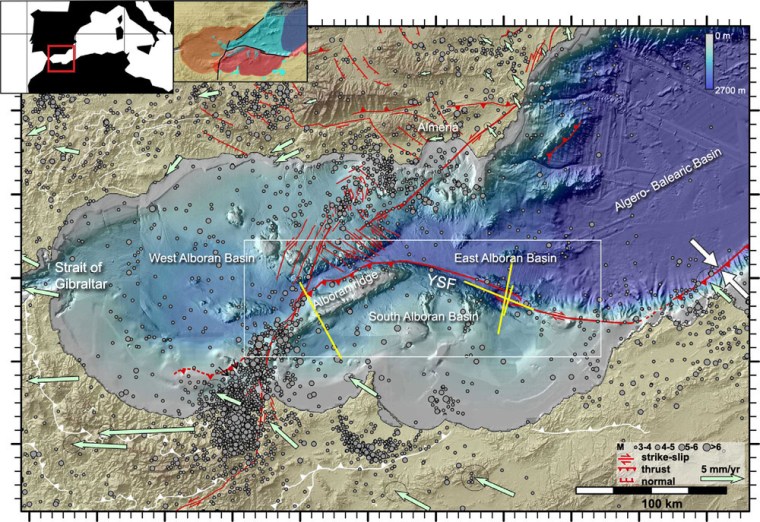
The West Alboran Basin is underlain by thinner continental crust (orange on the inset to the map) than beneath southern Spain and western Algeria. Normal crust underpins the Southern Alboran Basin. To the east are the deeper East Alboran and Algero-Balearic Basins, the floor of the latter being true oceanic crust and that of the former created in a now extinct island arc. Running ENE to WSW across the Alboran Basin are two ridges on the sea floor. Tectonic motions determined using the Global Positioning System reveal that the African plate is moving slowly westwards at up to 1 cm yr-1, about 2 to 3 times faster than the European plate. This reflected by the dextral strike-slip along the active ~E-W Yusuf Fault (YSF). This bends southwards to roughly parallel the Alboran Ridge, and becomes a large thrust fault that shows up on ship borne seismic reflection sections. The reflection seismic survey also shows that the shallow crust beneath the Alboran Ridge is being buckled under compression above the thrust. The thrust extends to the base of the African continental crust, which is beginning to override the arc crust of the East Alboran basin. Effectively, this system of major faults seems to have become a plate boundary between Africa and Europe in the last 5 million years and has taken up about 25 km of convergence between the two plates. An estimated 16 km of this has taken place across the Alboran Ridge Thrust which has detached the overriding African crust from the mantle beneath.

The authors estimate an 8.5 to 10 km depth beneath the Alboran fault system at which the overriding crust changes from ductile to brittle deformation – the threshold for strains being taken up by earthquakes. By comparison with other areas of seismic activity, they reckon that there is a distinct chance of much larger earthquakes (up to M 8) in the geologically near future. A great earthquake in this region, where the Mediterranean narrows towards the Strait of Gibraltar, may generate a devastating tsunami. An extension of the Africa-Europe plate boundary into the Atlantic is believed to have generated a major earthquake that launched a tsunami to destroy Lisbon and batter the Atlantic coasts of Portugal, Spain and NW Africa on 1st November 1755. The situation of the active plate boundary in the Alboran Basin may well present a similar, if not worse, risk of devastation.

Should you worry about being killed by a meteorite?

In 1994 Clark Chapman of the Planetary Science Institute in Arizona and David Morrison of NASA’s Ames Research Center in California published a paper that examined the statistical hazard of death by unnatural causes in the United States (Chapman, C. & Morrison, D. 1994. Impacts on the Earth by asteroids and comets: assessing the hazard. Nature, v. 367, p. 33–40; DOI:10.1038/367033a0). Specifically, they tried to place the risk of an individual being killed by a large asteroid (~2 km across) hitting the Earth in the context of more familiar unwelcome causes. Based on the then available data about near-Earth objects – those whose orbits around the Sun cross that of the Earth – they assessed the chances as ranging between 1 in 3,000 and 1 in 250,000; a chance of 1 in 20,000 being the most likely. The results from their complex calculations turned out to be pretty scary, though not as bad as dying in a car wreck, being murdered, burnt to death or accidentally shot. Asteroid-risk is about the same as electrocution, at the higher-risk end, but significantly higher than many other causes with which the American public are, unfortunately, familiar: air crash; flood; tornado and snake bite. The lowest asteroid-risk (1 in 250 thousand) is greater than death from fireworks, botulism or trichloroethylene in drinking water; the last being 1 in 10 million.

Chapman and Morrison cautioned against mass panic on a greater scale than Orson Welles’s 1938 CBS radio production of H.G. Wells’s War of the Worlds allegedly resulted in. Asteroid and comet impacts are events likely to kill between 5,000 and several hundred million people each time they happen but they occur infrequently. Catastrophes at the low end, such as the 1908 Tunguska air burst over an uninhabited area in Siberia, are likely to happen once in a thousand years. At the high end, mass extinction impacts may occur once every hundred million years. As might be said by an Australian, ‘No worries, mate’! But you never know…

Michelle Knapp’s Chevrolet Malibu the morning after a stony-iron mmeteorite struck it. Bought for US$ 300, Michelle sold the car for US$ 25,000 and the meteorite fetched US$ 50,000 (credit: John Bortle)

How about ordinary meteorites that come in their thousands, especially when the Earth’s orbit takes it through the former paths taken by disintegrating comets? When I was a kid rumours spread that a motor cyclist had a narrow escape on the flatlands around Kingston-upon-Hull in East Yorkshire, when a meteorite landed in his sidecar: probably apocryphal. But Michelle Knapp of Peeskill, New York, USA had a job for the body shop when a 12 kg extraterrestrial object hit her Chevrolet Malibu, while it was parked in the driveway. In 1954, Ann Hodges of Sylacauga, Alabama was less fortunate during an afternoon nap on her sofa, when a 4 kg chondritic meteorite crashed through her house roof, hit a radiogram and bounced to smash into her upper thigh, badly bruising her. For an object that probably entered the atmosphere at about 15 km s-1, that was indeed a piece of good luck resulting from air’s viscous drag, the roof impact and energy lost to her radiogram. The offending projectile became a doorstop in the Hodge residence, before the family kindly donated it to the Alabama Museum of Natural History. Another fragment of the same meteorite, found in a field a few kilometres away, fetched US$ 728 per gram at Christie’s auction house in 2017. Perhaps the most unlucky man of the 21st century was an Indian bus driver who was killed by debris ejected when a meteorite struck the dirt track on which he was driving in Tamil Nadu in 2016 – three passengers were also injured. Even that is disputed, some claiming that the cause was an explosive device.

The risk of landslides in Africa

The most widespread risk from natural hazards is, with little doubt, that posed by ground instability; landslides and landslips; mudflows; rock avalanches and a range of other categories in which large volumes of surface material are set in motion. They can be triggered by earthquakes, volcanism or heavy rainfall that changes the physical properties of rock and soil. Not only steep slopes pose a risk, for some affect ground with quite gentle topography, as witness the terrible scenes from Sulawesi triggered by the 28 September 2018 magnitude 7.5 earthquake beneath the Minhasa Peninsula. This set in motion mudflows on gently sloping ground when the seismic waves caused liquefaction of unconsolidated sediments that not only shattered dwellings by the lateral motion, but whole communities sank into the slurry with little trace. The rapid events left a death toll confirmed at 2010 people with about 5000 missing, feared to have been swallowed by the earth. In the last 9 months mass movement has resulted in fatalities in many places, the most publicised being in Uganda, Japan, Philippines, Sulawesi, Ethiopia, Sumatra, South India, Bangladesh, California, Nepal, and the list grows as it does every year.

407458aa.2
Types of mass movement (Credit: US Geological Survey

As well as purely natural causes, human activities, such as deforestation, excavations and dumping of materials, greatly exacerbate risks. The South Wales former coal-mining communities commemorate every year the collapse of a mine spoil heap on a steep hillside on 21 October 1966 that engulfed a primary school at Aberfan, killing 116 small children and 28 adults. Wherever they occur, there seems to be little chance of escape for those in their path. Slowly it has become possible for geoscientists to outline areas that are potentially at risk from catastrophic mass wastage, sometimes from the distribution of scars of previous events on remotely sensed images, but increasingly by multivariate analysis of landscapes in terms of the factors that may contribute to future ground failures. The principal ones are: topographic slope and relief; annual rainfall, especially the likely precipitation in a single day; vegetation cover, particularly by trees; strength of surface rock and soils, including degrees of consolidation, interbedding and water content; geological structure, such as the trajectory of faults, degree of  jointing and the dip of strata. Modelling risk has to grapple with the global scale of the problem, which cannot be addressed in the least developed regions by piecemeal local studies, although those are urgent, of course, in areas with recorded instances of catastrophic ground failure. Regional studies can screen vast areas of probably low risk so that meagre resources can focus on those that appear to be most dangerous to populated places.

afr landslide
Degree of risk from landslides of all types in the northern part of the East African Rift System (Credit: Broeckx et al. 2018; Fig. 6)

Belgian engineering geologists and GIS specialists have assembled a monumental risk assessment of Africa, together with a bibliography of all published work on mass movement across the continent (Broeckx, J. et al. 2018. A data-based landslide susceptibility map of Africa. Earth-Science Reviews, v. 185, p. 102-121; DOI: 10.1016/j.earscirev.2018.05.002). They point out that Google Earth’s 3-D viewing potential at fine spatial resolution provides a free and rapid means of mapping scars of previous earth movements in considerable detail over areas that data analysis suggests to be susceptible. Their paper provides continent-scale maps of the parameters that they used as well as maps showing several versions of their risk analysis. The supplementary data to the paper include downloadable, full-resolution maps of landslide susceptibility.