A major boost for the ‘Hydrogen Economy’?

The notion of large-scale use of hydrogen as an energy source has a surprisingly long history. It was first proposed by J.B.S. Haldane in 1923, who envisaged electrolysis of water – releasing hydrogen and oxygen – using power from wind turbines to address this renewable source’s highly variable output effectively by storing it in the form of hydrogen. Since the only other output is oxygen, a hydrogen economy might seem to avoid global warming from the current release of greenhouse gases. However, as a 2023 post on Earth-logs concluded, of all the means for mass production and use of hydrogen only one source is a truly ‘green’ energy source: that emitted from rock by natural processes: so-called ‘white’ hydrogen.  It is known to be generated by the breakdown of the mineral olivine [(Fe,Mg)2SiO4] by water in the absence of oxygen:

3Fe2SiO4 + 2H2O → 2 Fe3O4 + 3SiO­2 +3H2

A more complex reaction is the hydration of olivine to the mineral serpentine [Mg3Si2O5(OH)4], which also yields hydrogen. Olivine is the most important mineral in the Earth’s mantle and abundant in crustal basalts and ultramafic rocks too. Oceanic lithosphere (ophiolites) added by tectonics to the continental crust form obvious targets for seeking natural hydrogen seepage. Yet such surface gas escapes have been documented only from a few sites, including an irrigation well in rural Mali that emitted gas containing 98% hydrogen, and a few natural springs from the Oman ophiolite.

The latest study may have taken the hydrogen economy to a literally deeper level  (Sherwood Lollar, B. &  Warr, O. 2026. Decadal record of continental H2 reservoirs reveals potential for subsurface microbial life and natural H2 exploration. Proceedings of the National Academy of Sciences, v. 123, article e2603895123; DOI: 10.1073/pnas.2603895123. PDF requests to owarr@uOttawa.ca and/or barbara.sherwoodlollar@utoronto.ca). Over fifteen years Barbara Sherwood Lollar and Oliver Warr of the Universities of Toronto and Ottawa, Canada monitored gas released by 35 boreholes originally drilled to assess and plan mining of an orebody in Precambrian basement rocks at Kidd Creek near Timmins, Ontario. On average, each of the boreholes released 8 kg of hydrogen per year. Scaled up to the mine’s 15 thousand exploratory boreholes, the mine itself  is estimated to be yielding 140 metric tons of the gas annually. That could provide 4.7 gigawatts of energy per annum, sufficient for the needs of more than 400 Canadian homes.
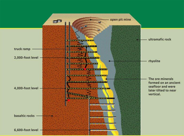
Schematic cross section through the Kidd Creek Mine, Ontario, Canada. Source American Museum of Natural History

The Timmins mining district is typical of Archaean greenstone belts in the Canadian Shield and in cratons across the world: supracrustal rocks including ultramafic and mafic volcanics and a variety of metasedimentary rocks. The Timmins district is historically Canada’s largest gold producer, but also hosts ores of many other metals. The Kidd Creek Cu-Ag-Zn mine is one of the deepest in North America, which penetrates interlayered felsic, mafic, ultramafic, and metasedimentary rocks to a depth of 2.9 km below the surface. The ores formed by submarine hydrothermal processes around 2.7 Ga ago. The sampled boreholes were drilled horizontally at mine levels between 2.04 to 2.9 km below the surface to penetrate the ore zone and its mafic-ultramafic host rocks. Rather than yielding gas, the holes release briny fluids in which hydrogen, helium and various hydrocarbon gases are dissolved. They are similar to fluids issuing from other deep mines, but differ in showing their formation mainly to be through inorganic reactions with the bed rock rather than as a result of microbial metabolism that exploits a variety of chemical interactions in the ore, such as reduction of sulfate ions to sulfide. The authors have studied hydrogen yields from a number of other mines in mafic-ultramafic rocks, which are comparable with Kidd Creek. So it may be that hydrogen in vast volumes is being emitted by existing and abandoned metal mines in such igneous terrains.

Sherwood Lollar and Warr authoritatively outline the economic potential of hydrogen production for remote communities and mines in greenstone-belt terrains. They also assess active serpentinisation of ophiolites and kimberlites by near-surface groundwater and associated microbial ecosystems as hydrogen sources, the few that have been studied seeming to produce even larger amounts of hydrogen. But they also note that their closer proximity to the surface means that these geological features are generally ‘open-systems’ prone to rapid loss of gases. However, in the manner of hydrocarbon gas fields, some ophiolites may host large amounts of hydrogen if they are capped by younger clay-rich sedimentary strata. Whatever, the global warming of what might be called the ‘Hydrocarbon Age’ is set to become a disaster. Breaking its death grip should be the principal economic agenda, which requires the most rapid turn to long-term energy alternatives. Natural hydrogen could be a part of that, and hopefully the work of Sherwood Lollar and Warr, and others like them, should lead to determined exploration and assessment of this novel physical resource. In Scandinavia a Nordic Hydrogen Route is being proposed. This Swedish-Finnish initiative is based on the Scandinavian Shield and its greenstone terrains and numerous mines driven into them. One would hope that its entrepreneurs are considering naturally emitted hydrogen rather than or as well as sources given other coloured labels.

See also: Canada’s Billion-Year-Old Rocks Could Hold the Future of Clean Energy. Sci Tech Daily, 21 May 2026.

Gravity survey reveals signs of Archaean tectonics in Canadian Shield

Much of the Archaean Eon is represented by cratons, which occur at the core of continental parts of tectonic plates. Having low geothermal heat flow they are the most rigid parts of the continental crust.  The Superior Craton is an area that makes up much of the eastern part of the Canadian Shield, and formed during the Late Archaean from ~4.3 to 2.6 billion years (Ga) ago. Covering an area in excess of 1.5 million km2, it is the world’s largest craton. One of its most intensely studied components is the Abitibi Terrane, which hosts many mines. A granite-greenstone terrain, it consists of volcano-sedimentary supracrustal rocks in several typically linear greenstone belts separated by areas of mainly intrusive granitic bodies. Many Archaean terrains show much the same ‘stripey’ aspect on the grand scale. Greenstone belts are dominated by metamorphosed basaltic volcanic rock, together with lesser proportions of ultramafic lavas and intrusions, and overlying metasedimentary rocks, also of Archaean age. Various hypotheses have been suggested for the formation of granite-greenstone terrains, the latest turning to a process of ‘sagduction’. However the relative flat nature of cratonic areas tells geologists little about their deeper parts. They tend to have resisted large-scale later deformation by their very nature, so none have been tilted or wholly obducted onto other such stable crustal masses during later collisional tectonic processes. Geophysics does offer insights however, using seismic profiling, geomagnetic and gravity surveys.

The Geological Survey of Canada has produced masses of geophysical data as a means of coping with the vast size and logistical challenges of the Canadian Shield. Recently five Canadian geoscientists have used gravity data from the Canadian Geodetic Survey to model the deep crust beneath the huge Abitibi granite-greenstone terrain, specifically addressing variations in its density in three dimensions. They also used cross sections produced by seismic reflection and refraction data along 2-D survey lines (Galley, C. et al. 2025. Archean rifts and triple-junctions revealed by gravity modeling of the southern Superior Craton. Nature Communications, v. 16, article 8872; DOI: 10.1038/s41467-025-63931-z). The group found that entirely new insights emerge from the variation in crustal density down to its base at the Moho (Mohorovičić discontinuity). These data show large linear bulges in the Moho separated by broad zones of thicker crust.

Geology of the Abitibi Terrane (upper),; Depth to the Moho beneath the Abitibi Terrane with rifts and VMS deposits superimposed (lower). Credit: After Galley et al. Figs 1 and 5.

Galley et al. suggest that the zones are former sites of lithospheric extensional tectonics and crustal thinning: rifts from which ultramafic to mafic magmas emerged. They consider them to be akin to modern mid-ocean and continental rifts. Most of the rifts roughly parallel the trend of the greenstone belts and the large, long-lived faults that run west to east across the Abitibi Terrain. This suggests that rifts formed under the more ductile lithospheric condition of the Neoarchaean set the gross fabric of the granites and greenstones. Moreover, there are signs of two triple junctions where three rifts converge: fundamental features of modern plate tectonics. However, both rifts and junctions are on a smaller scale than those active at present. The rift patterns suggest plate tectonics in miniature, perhaps indicative of more vigorous mantle convection during the Archaean Eon.

There is an interesting spin-off. The Abitibi Terrane is rich in a variety of mineral resources, especially volcanic massive-sulfide deposits (VMS). Most of them are associated with the suggested rift zones. Such deposits form through sea-floor hydrothermal processes, which Archaean rifting and triple junctions would have focused to generate clusters of ‘black smokers’ precipitating large amounts of metal sulfides. Galley et al’s work is set to be applied to other large cratons, including those that formed earlier in the Archaean: the Pilbara and Kaapvaal cratons of Australia and South Africa. That could yield better insights into earlier tectonic processes and test some of the hypotheses proposed for them

See also: Archaean Rifts, Triple Junctions Mapped via Gravity Modeling. Scienmag, 6 October 2025

Ancient mining pollutants in river sediments reveal details of early British economic history

People have been mining in Britain since Neolithic farmers opened the famous Grimes Graves in Norfolk – a large area dotted with over 400 pits up to to 13 metres deep. The target was a layer of high quality black flint in a Cretaceous limestone known as The Chalk. Later Bronze Age people in Wales and Cornwall drove mine shafts deeper underground to extract copper and tin ores to make the alloy bronze. The Iron Age added iron ore to the avid search for sources of metals. The production and even export of metals and ores eventually attracted the interest of Rome. Roman invasion in 43 CE during the reign of Claudius annexed most of England and Wales to create the province of Britannia. This lasted until the complete withdrawal of Roman forces around 410 CE. Roman imperialism and civilisation depended partly on lead for plumbing and silver coinage to pay its legionaries. Consequently, an important aspect in Rome’s four-century hegemony was mining, especially for lead ore, as far north as the North Pennines. This littered the surface in mining areas with toxic waste. Silver occurs in lead ore in varying proportions. In the Bronze Age early metallurgists extracted silver from smelted, liquid lead by a process known as cupellation. The molten Pb-Ag alloy is heated in air to a much higher temperature than its melting point, when lead reacts with oxygen to form a solid oxide (PbO) and silver remains molten.

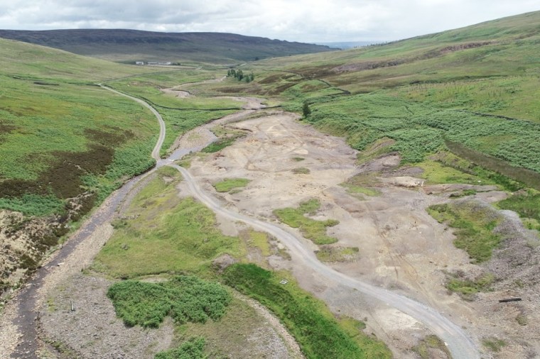
Mine waste in the North Pennine orefield of England. Credit: North Pennines National Landscape

Until recently, historians believed that the fall of the Western Empire brought economic collapse to Britain. Yet archaeologists have revealed that what was originally called the “Dark Ages” (now Early Medieval Period) had a thriving culture among both the remaining Britons and Anglo Saxon immigrants. A means of tracking economic activity is to measure the amount of pollutants from mining waste at successive levels in the alluvium of rivers that flow through orefields. Among the best known in Britain is the North Pennine Orefield of North Yorkshire and County Durham through which substantial rivers flow eastwards, such as the River Ure that flows through the heavily mined valley of Wensleydale. A first attempt at such geochemical archaeology has been made by a British team led by Christopher Loveluck of Nottingham University (Loveluck, C.P. and 10 others 2025. Aldborough and the metals economy of northern England, c. AD 345–1700: a new post-Roman narrative. Antiquity: FirstView, online article; DOI: 10.15184/aqy.2025.10175). Aldborough in North Yorkshire – sited on the Romano-British town of Isurium Brigantum – lies in the Vale of York, a large alluvial plain. The River Ure has deposited sands, silts and muds in the area since the end of the last Ice Age, 11 thousand years ago.

Loveluck et al. extracted a 6 m core from the alluvium on the outskirts of Aldborough, using radiocarbon and optically-stimulated luminescence of quartz grains to calibrate depth to age in the sediments.  The base of the core is Mesolithic in age (~6400 years ago) and extends upwards to modern times, apparently in an unbroken sequence. Samples were taken for geochemical analysis every 2 cm through the upper 1.12 m of the core, which spans the Roman occupation (43 to 410 CE), the early medieval (420 to 1066 CE), medieval (1066 to 1540 CE), post-medieval (1540 to 1750 CE) and modern times (1750 CE to present). Each sample was analysed for 56 elements using mass spectrometry; lead, silver, copper, zinc, iron and arsenic being the elements of most interest in this context. Other data gleaned from the sediment are those of pollen, useful in establishing climate and ecological changes. Unfortunately, the metal data begin in 345 CE, three centuries after the Roman invasion, by which time occupation and acculturation were well established. The authors assume that Romans began the mining in the North Pennines. They say nothing about the pre-mining levels of pollution from the upstream orefield nor mining conducted by the Iron Age Brigantes. For this kind of survey, it is absolutely essential that a baseline is established for the pollution levels under purely natural conditions. The team could have analysed sediment from the Mesolithic when purely natural weathering, erosion and transport could safely be assumed, but they seem not to have done that.

The team has emphasised that their data suggest that mining for lead continued and even increased through the ‘Dark Ages’ rather than declining, in an economic ‘slump’ once the Romans left, as previous historians have suggested. Lead pollution continued at roughly the same levels as during the Roman occupation through the Early Medieval Period and then rose to up to three times higher after the late 14th century. The data for silver are different. The Ag data from Aldborough show a large ‘spike’ in 427 to 427 CE. Interestingly this is after the Roman withdrawal. Its level in alluvium then ‘flatlines’ at low abundances until the beginning of the 14th century when again there is a series of ‘booms’. This seems to me to mark sudden spells of coining, after the Romans left perhaps first to ensure a money economy remained possible, and then as a means of funding wars with the French in the 14th century. The authors also found changing iron abundances, which roughly double from low Roman levels to an Early Medieval peak and then fall in the 11th century: a result perhaps of local iron smelting. The overall patterns for zinc and copper differ substantially from those of lead, as does that for arsenic which roughly follows the trend for iron. That might indicate that local iron production was based on pyrite (FeS2) which can contain arsenic at moderate concentrations: pyrite is a common mineral in the ore bodies of the North Pennines’ The paper by Loveluck et al. is worth reading as a first attempt to correlate stratigraphic geochemistry data with episodes in British and, indeed, wider European history. But I think it has several serious flaws, beyond the absence of any pre-Roman geochemical baseline, as noted above. No data are presented for barium (Ba) and fluorine (F) derived from the gangue minerals baryte (BaSO4) and fluorite (CaF2), which outweigh lead and zinc sulfides in North Pennine ore bodies, yet had no use value until the Industrial Revolution. They would have made up a substantial proportion of mine spoil heaps – useful ores would have been picked out before disposal of gangue – whose erosion, comminution and transport would make contributions to downstream deposition of alluvium consistent with the pace of mining. That is: Ba and F data would be far better guides to industrial activity. There is a further difficulty with such surveys in northern Britain. The whole of the upland areas were subjected to repeated glaciation, which would have gathered exposed ore and gangue and dumped it in till, especially in the numerous moraines exposed in valleys such as Wensleydale. Such sources may yield sediment in periods of naturally high erosion during floods. Finally, the movement of sediment downstream is obviously not immediate, especially when waste is disposed in large dumps near mines Therefore phases of active mining may not contribute increased toxic waste far downstream until decades or even centuries later. These factors could easily have been clarified by a baseline study from earlier archaeological periods when mining was unlikely, into which the Aldborough alluvium core penetrates

A cure for the Great British Pothole Plague?

Anyone who read the manifestos of the mainstream political parties in the UK – there may not be many who did – would have been amused to see that all promised to resolve the plague of potholes in the countries roads, both major and minor. For decades road users have been alarmed when hitting a pothole and in some cases had damage inflicted on their vehicles, and in the case of those on two wheels, on themselves. The RAC (Royal Automobile Club) has estimated that there are, on average, six potholes per mile on Britain’s roads: the greatest density in Europe. The AA (Automobile Association) estimated that almost £0.6 billion was spent in 2024 repairing pothole-damaged vehicles. This is not a new phenomenon. Before the advent of turnpike trusts in the late 18th century, which maintained roads travelled by Britain’s mail coach services, it was not uncommon to encounter potholes up to two metres deep. Legend has it that on one such route through northern Nottinghamshire two coach horses fell into a pothole and drowned. Scottish engineer, John Loudon McAdam invented a solution around 1820: crushed stone laid on the road surface in slightly convex layers, the topmost being bonded with stone dust. This ‘macadam’ surface created cambered highways that drained rainwater to the sides and downwards. Modern roads are still based on that principle, with the addition of tar or bitumen to the top layer to produce a hard, impermeable surface, which also prevents aggregate and dust being sucked from the surface by fast moving vehicles.

A spore of the club moss Lycopodium

So, why the potholes? Several reasons: increased traffic; heavier vehicles; less maintenance; patching rather than resurfacing. Most important: the materials and the weather. Dry, hot weather softens the bitumen and drives out volatile hydrocarbons making the bitumen less plastic. The pounding of tyres in cooler weather fractures the now stiffened bitumen, mainly at microscopic scales. Wetting of the tarmac seeps water into the microfractures. The formation of ice films jacks opens the microfractures and produces more in the cold stiff bitumen, eventually to separate the particles of aggregate in the asphalt. The wearing course begins to crumble so that aggregate grains escape and scatter. Thus weakened, the top layer breaks up into larger fragments and a pit forms to join up with others so that a pothole forms and grows. Wheels of traffic bounce when they cross a pothole, the shock of which causes the centre of degradation to shift and create more cavities. Simply filling the existing potholes merely serves to create new ones: a vicious cycle that can only be broken by complete resurfacing: the traffic cones come out!.

All this has been known for well over a century by civil engineers. Around the start of the 21st century – maybe slightly earlier – it dawned on engineers that the critical problem was degradation of bitumen. A petroleum derivative, occurring naturally as surface seeps in some oilfields, bitumen is chemically complex: a combination of asphaltenes and maltenes (resins and oils). Deterioration of bitumen through evaporation, oxidation and exposure to ultraviolet radiation decreases the maltene content and stiffens the binding agent in asphalt. So the earliest attempts at reducing pothole formation centred on rejuvenation by periodically adding substitutes for maltenes to road surfaces. Diesel (gas-oil) works, but is obviously hazardous. More suitable are vegetable oils such as waste cooking oils or those produced by pyrolysis of cotton, straw, wood waste and even animal manure. The problem is getting the rejuvenators into existing asphalt surfaces: clearly, simply spraying them on the surface seems a recipe for disaster! A solution that dawned on engineers around 2005 was to make bitumen that is ‘self-healing’.

Schematic of the production of microcapsules from club moss spores to contain sunflower oil to be used in self-healing asphalt (Credit: Alpizar-Reyes, E. et al. 2022)

Simply mixing rejuvenators into bitumen during asphalt manufacture will not do the trick, for the result would be a weakened binding agent at the outset. For the last 15 years researchers have sought means of adding rejuvenators in  porous capsules, to release them as microfractures begin to form: on demand, as it were. There have been dozens of publications about experiments that found ‘sticking points’. However, in early 2025 what seems to be a viable breakthrough splashed in the British press. It was made by an interdisciplinary team of scientists from King’s College London and Swansea University, in collaboration with scientists in Chile. They chemically treated spores of Lycopodium club mosses to perforate their cell walls and clear out their contents to be replaced by sunflower oil, an effective bitumen rejuvenator. Experiments showed that such microcapsules released the oil to heal cracks in aged  bitumen samples in around an hour. Mixed into bitumen to be added to asphalt they would remain ‘dormant’ until a microfracture formed in their vicinity released it, thereby making the asphalt binder self healing.

Will such an advance finally resolve the pothole plague? It may take a while …

See: Alpizar-Reyes, E. et al. 2022. Biobased spore microcapsules for asphalt self-healing. ACS Applied Materials & Interfaces, v. 14, p. 31296-31311; DOI: 10.1021/acsami.2c07301

A fully revised edition of Steve Drury’s book Stepping Stones: The Making of Our Home World can now be downloaded as a free eBook

Global natural hydrogen resources: a CO2 free future??

The idea of a ‘Hydrogen Economy’ has been around for at least six decades, its main attraction being that when hydrogen is burned it combines with oxygen to form H2O. It might seem to be the ultimate ‘green’ energy source, but it is currently being touted by governments and petroleum companies in what is widely regarded as ‘green washing’. The technology favoured by that axis uses steam reforming of the methane that dominates natural petroleum gas, through the reaction:

CH4 + H2O  → CO + 3H2

It’s actually not much different from producing coke gas from coal, which began in the 19th century and is now largely abadoned. Because carbon monoxide (CO) reacts with atmospheric oxygen to form CO2 this process is by no means ‘green’ and is properly referred to as ‘grey’ hydrogen. Only if the CO is stored permanently underground could steam reforming not add to greenhouse warming. That puts the approach in the same category as ‘carbon capture and storage’, with all the possible difficulties inherent in that technology, which has yet to be demonstrated on a large scale. Such hydrogen is classified as a ‘blue’. Colour coding hydrogen is described nicely by the British National Grid. They give another six varieties. Green and yellow hydrogen are produced by electrolysing water using wind or solar power respectively. The pink variety uses nuclear power in the same fashion. Black or brown hydrogen is that produced by coking coal or stewing-up brown coal (lignite) which amazingly are contemplated in Australia and Germany. There is even a turquoise variety can be produced if methane is somehow turned into hydrogen and solid carbon using renewables. There is another category (white) which is hydrogen produced by a variety of natural, geochemical processes.

Distribution of ophiolites around the Eastern Mediterranean and Black Seas. Many orogenic belts are endowed to a similar extent. (Credit: Gültekin Topuz, Istanbul Technical University)

Earth-logs discussed white hydrogen in March 2023 when news emerged of gas that was 98% hydrogen leaking from a water borehole in Mali. The local people harnessed this surprising resource to generate electricity for their village. It also emerges in springs from ultramafic rocks, having formed through weathering of the mineral olivine:

3Fe2SiO4 + 2H2O → 2 Fe3O4 + 3SiO­2 +3H2

Much the same reaction occurs beneath the ocean floor where hydrothermal fluids alter basalts and in geothermal springs that emerge from onshore basalt lavas. Such ‘white’ hydrogen emissions are widespread. So an unknown, but possibly huge amount of hydrogen is leaking into the atmosphere continuously. Because of its tiny nucleus – just a single proton – atmospheric hydrogen quickly escapes to outer space: what a waste! Equally as interesting is that inducing the breakdown of ultramafic rock to yield hydrogen, by pumping water and carbon dioxide into them, may also be a means of leak-free carbon sequestration. This produces the complex mineral serpentine and magnesium carbonate. The reaction gives off heat and so is self sustaining until pumping is stopped.

It has been estimated that by 2050 the annual global demand for hydrogen will reach 530 million t.  Just how big is the potential resource to meet such a demand? Natural weathering and hydrothermal processes have always functioned. Some of the hydrogen produced by them may have built-up in reservoirs like the one in Mali, some is escaping. Neither the magnitude of annual natural generation of hydrogen nor the amount trapped in porous sedimentary rocks are known in any detail. A recent survey of how much may be trapped gives a range from 103 to 1010 million metric tons (Ellis, G.S. & Gelman, S.E. 2024. Model predictions of global geologic hydrogen resources. Science Advances, v. 10, article eado0955; DOI: 10.1126/sciadv.ado0955), most probably 5.6 trillion t. If only a tenth of that is recoverable, replacing fossil-fuel energy with that from white hydrogen to achieve net-zero CO2 emissions would be sustainable for about 400 years. That magnitude of trapped hydrogen reserves well exceeds all proven reserves of natural gas.

This estimate assumes using only hydrogen that has been naturally produced and stored beneath the Earth’s surface. Basalts and ultramafic rocks exposed at the land surface as ophiolites – ancient oceanic crust thrust onto continental crust – are abundant on every continent. Inducing hydrogen-producing chemical reactions in them by pumping water and CO2 into them is little different from the technology being used in fracking. This potential resource is effectively limitless. Combined with renewable energy technology, a hydrogen economy has no conceivable need for fossil fuels, except as organic-chemistry feedstock. Such a scenario for stabilising climate is almost certainly feasible. It could use the capital, technology and skills currently deployed by the petroleum industry that is currently driving society and the Earth in the opposite direction. It is capable of drilling 10 km below the continental surface or the ocean floor, and even into the Earth’s mantle that is made of . . . ultramafic rock.

Best wishes for the festive season to all Earth-logs followers and visitors

A major breakthrough in carbon capture and storage?

Carbon capture and storage is in the news most weeks and is increasingly on the agenda for some governments. But plans to implement the CCS approach to reducing and stopping global warming increasingly draws scorn from scientists and environmental campaigners. There is a simple reason for their suspicion. State engagement, in the UK and other rich countries, involves major petroleum companies that developed the oil and gas fields responsible for unsustainably massive injection of CO2 into the atmosphere. Because they have ‘trousered’ stupendous profits they are a tempting source for the financial costs of pumping CO2 into porous sedimentary rocks that once contained hydrocarbon reserves. Not only that, they have conducted such sequestration over decades to drive out whatever petroleum fluids remaining in previously tapped sedimentary strata. For that second reason, many oil companies are eager and willing to comply with governmental plans, thereby seeming to be environmentally ‘friendly’. It also tallies with their ambitions to continue making profits from fossil-fuel extraction. But isn’t that simply a means of replacing the sequestered greenhouse gas with more of it generated by burning the recovered oil and natural gas; i.e. ‘kicking the can down the road’? Being a gas – technically a ‘free phase’ – buried CO2 also risks leaking back to the atmosphere through fractures in the reservoir rock. Indeed, some potential sites for its sequestration have been deliberately made more gas-permeable by ‘fracking’ as a means of increasing the yield of petroleum-rich rock. Finally, a litre of injected gas can drive out pretty much the same volume of oil. So this approach to CCS may yield a greater potential for greenhouse warming than would the sequestered carbon dioxide itself.

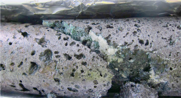
Image of calcite (white) and chlorite (cyan) formed in porous basalt due to CO2-charged water-rock interaction at the CarbFix site in Iceland. (Credit: Sandra Ósk Snæbjörnsdóttir)

Another, less widely publicised approach is to geochemically bind CO2 into solid carbonates, such as calcite (CaCO­3), dolomite (CaMgCO3), or magnesite (MgCO3). Once formed such crystalline solids are unlikely to break down to their component parts at the surface, under water or buried. One way of doing this is by the chemical weathering of rocks that contain calcium- and magnesium-rich minerals, such as feldspar (CaAl2Si2O8), olivine ([Fe,Mg]2SiO4) and pyroxene ([Fe,Mg]CaSi2O6) . Mafic and ultramafic rocks, such as basalt and peridotite are commonly composed of such minerals. One approach involves pumping the gas into a Icelandic borehole that passes through basalt and letting natural reactions do the trick. They give off heat and proceed quickly, very like those involved in the setting of concrete. In two experimental field trials 95% of injected CO2 was absorbed within 18 months. Believe it or not, ants can do the trick with crushed basalt and so too can plant roots. There have been recent experiments aimed at finding accelerants for such subsurface weathering (Wang, J. et al. 2024. CO2 capture, geological storage, and mineralization using biobased biodegradable chelating agents and seawater. Science Advances, v. 10, article eadq0515; DOI: 10.1126/sciadv.adq0515). In some respects the approach is akin to fracking. The aim is to connect isolated natural pores to allow fluids to permeate rock more easily, and to release metal ions to combine with injected CO2.

Chelating agents are biomolecules that are able to dissolve metal ions; some are used to remove toxic metals, such as lead, mercury and cadmium, from the bodies of people suffering from their effects. Naturally occurring ones extract metal ions from minerals and rocks and are agents of chemical weathering; probably used by the aforesaid ants and root systems. Wang and colleagues, based at Tohoku University in Japan, chose a chelating agent GLDA (tetrasodium glutamate diacetate –  C9H9NNa4O8) derived from plants, which is non-toxic, cheap and biodegradable. They injected CO2 and seawater containing dissolved GDLA into basaltic rock samples. The GDLA increases the rock’s porosity and permeability by breaking down its minerals so that Ca and Mg ions entered solution and were thereby able to combine with the gas to form carbonate minerals. Within five days porosity was increased by 16% and the rocks permeability increased by 26 times. Using electron microscopy the authors were able to show fine particles of carbonate growing in the connected pores. In fact these carbonate aggregates become coated with silica released by the induced mineral-weathering reactions. Calculations based on the previously mentioned field experiment in Iceland suggest that up to 20 billion tonnes of CO2 could be stored in 1.3 km3 of basalt treated in this way: about 1/25000 of the active rift system in Iceland (3.3 x 10⁴ km2 covered by 1 km of basalt lava). In 2023 fossil fuel use emitted an estimated 36.6 bllion tons of CO2 into the atmosphere.

So, why do such means of efficiently reducing the greenhouse effect not receive wide publicity by governments or the Intergovernmental Panel on Climate Change? Answers on a yellow PostIt™ please . . .

Geology cracks Stonehenge mysteries

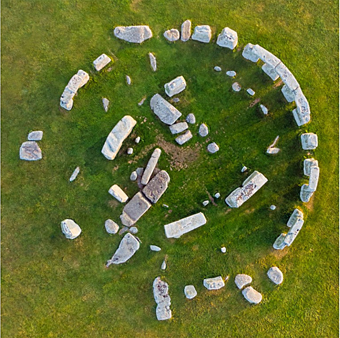
High resolution vertical aerial photograph of Stonehenge. (Credit: Gavin Hellier/robertharding/Getty)

During the later parts of the Neolithic the archipelago now known as the British Isles and Ireland was a landscape on which large stone buildings with ritual and astronomical uses were richly scattered. The early British agricultural societies also built innumerable monuments beneath which people of the time were buried, presumably so that they remained in popular memory as revered ancestors. Best known among these constructions is the circular Stonehenge complex of dressed megaliths set in the riot of earlier, contemporary and later human-crafted features of the Chalk downs known as Salisbury Plain. Stonehenge itself is now known to have been first constructed some five thousand years ago (~3000 BCE) as an enclosure surrounded by a circular ditch and bank, together with what seems to have been a circular wooden palisade. This was repeatedly modified during the following two millennia. Around 2600 BCE the wooden circle was replaced by one of stone pillars, each weighing about 2 t. These ‘bluestones’ are of mainly basaltic igneous origin unknown in the Stonehenge area itself. The iconic circle of huge, 4 m monoliths linked by 3 m lintel stones that enclose five even larger trilithons arranged in a horseshoe dates to the following two-centuries to 2400 BCE coinciding with the Early Bronze Age when newcomers from mainland Europe – perhaps as far away as the steppe of western Russia – began to replace or assimilate the local farming communities. This phase included several major modifications of the earlier bluestones.

It might seem that the penchant for circular monuments began with the Neolithic people of Salisbury Plain, and then spread far and wide across the archipelago in a variety of sizes. However, it seems that building of sophisticated monuments, including stone circles, began some two centuries earlier than in southern England in the Orkney Islands 750 km further north and, even more remote, in the Outer Hebrides of Scotland. A variety of archaeological and geochemical evidence, such as the isotopic composition of the bones of livestock brought to the vicinity of Stonehenge during its period of development and use, strongly suggests that people from far afield participated. Remarkably, a macehead made of gneiss from the Outer Hebrides turned up in an early Stonehenge cremation burial. Ideas can only have spread during the Neolithic through the spoken word. As it happens, the very stones themselves came from far afield. The earliest set into the circular structure, the much tinkered-with bluestones, were recognised to be exotic over a century ago. They match late Precambrian dolerites exposed in western Wales, first confirmed in the 1980s through detailed geochemical analyses by the late Richard Thorpe and his wife Olwen Williams-Thorpe of the Open University. Some suggested that they had been glacially transported to Salisbury Plain, despite complete lack of any geological evidence. Subsequently their exact source in the Preseli Hills was found, including a breakage in the quarry that exactly matched the base of one of the Stonehenge bluestones. They had been transported 230 km to the east by Neolithic people, using perhaps several means of transport. The gigantic monoliths, made of ‘sarsen’ – a form of silica-cemented sandy soil or silcrete – were sourced from some 25 km away where Salisbury Plain is still liberally scattered with them. Until recently, that seemed to be that as regards provenance, apart from a flat, 5 x 1 m slab of sandstone weighing about 6 t that two fallen trilithon pillars had partly hidden. At the very centre of the complex, this had been dubbed the ‘Altar Stone’, originally supposed to have been brought with the bluestones from west Wales.

The stones of Stonehenge colour-coded by lithology. The sandstone ‘Altar Stone’ lies beneath fallen blocks of a trilithon at the centre of the circle. (Credit: Clarke et al. 2024, Fig 1a)

A group of geologists from Australia and the UK, some of whom have long been engaged with Stonehenge, recently decided to apply sophisticated geochemistry at two fragments broken from the Altar Stone, presumably when the trilithons fell on it (Clarke, A. J. I. et al.2024.  A Scottish provenance for the Altar Stone of Stonehenge. Nature v.632, p. 570–575; DOI: 10.1038/s41586-024-07652-1). In particular they examined various isotopes and trace-elements in sedimentary grains of zircon, apatite and rutile that weathering of igneous rocks had contributed to the sandstone, along with quartz, feldspar, micas and clay minerals. It turned out that the zircon grains had been derived from Mesoproterozoic and Archaean sources beneath the depositional site of the sediment (the basement). The apatite and rutile grains show clear signs of derivation from 460 Ma old (mid-Ordovician) granites. The basement beneath west Wales is by no stretch of the imagination a repository of any such geology. That of northern Scotland certainly does have such components, and it also has sedimentary rocks derived from such sources: the Devonian of Orkney and mainland Scotland surrounding the Moray Firth. Unlike the lithologically unique bluestones, the sandstone is from a thick and widespread sequence of terrestrial sediments colloquially known as the ‘Old Red Sandstone’. The ORS of NE Scotland was deposited mainly during the Devonian Period (419 to 369 Ma) as a cyclical sequence in a vast, intermontane lake basin. Much the same kinds of rock occur throughout the sequence, so it is unlikely that the actual site where the ‘Alter Stone’ was selected will ever be known.

To get the ‘Alter Stone’ (if indeed that is what it once was) to Stonehenge demanded transport from its source over a far more rugged route, three times longer than the journey that brought the bluestones from west Wales: at least 750 km. It would probably have been dragged overland. Many Neolithic experts believe that transport of such a large block by boat is highly unlikely; it could easily have been lost at sea and, perhaps more important, few would have seen it. An overland route, however arduous, would have drawn the attention of everyone en route, some of whom might have been given the honour of helping drag such a burden for part of the way. The procession would certainly have aroused great interest across the full extent of Britain. Its organisers must have known its destination and what it signified, and the task would have demanded fervent commitment. In many respects it would have been a project that deeply unified most of the population. That could explain why people from near and far visited the Stonehenge site, herding livestock for communal feasting on arrival. Evidence is now pointing to the construction and use of the ritual landscape of Salisbury Plain as an all-encompassing joint venture of most of Neolithic Britain’s population. It would come as no surprise if objects whose provenance is even further afield come to light. It remained in use and was repeatedly modified during the succeeding Bronze Age up to 1600 BCE. By that time, the genetic group whose idea it was had been assimilated, so that only traces of its DNA remain in modern British people. This seems to have resulted from waves of immigrants from Central Europe, the Yamnaya, who brought new technology and the use of metals and horses.

See also: Gaind, N. & Smith, R. 2024. Stonehenge’s enigmatic centre stone was hauled 800 kilometres from Scotland. Nature, v. 632, p. 484-485; DOI: 10.1038/d41586-024-02584-2; Addley, E. 2024. Stonehenge megalith came from Scotland, not Wales, ‘jaw-dropping’ study finds. The Guardian, 14 August 2024.

The Moon may have water resources in its soil

Apart from signs of water ice in permanently shadowed areas of some polar craters, the Moon’s surface has generally been considered to be very dry. Rocks returned by the various Apollo missions contain minute traces of water by comparison with similar rocks on Earth. They consist only of anhydrous minerals such as feldspars, pyroxenes and olivines. But much of the lunar surface is coated by regolith: a jumble of rock fragments and dust ejected from a vast number of impact craters over billions of years. It is estimated to be between 3 and 12 m deep. Much of the finer grained regolith is made up of silicate-glass spherules created by the most powerful impacts.

The lunar regolith at Tranquillity Base bearing an astronaut’s bootprint (Credit: Buzz Aldrin, NASA Apollo 11, Photo ID AS11-40-5877)

The scientific and economic (i.e. mining) impetus for the establishment of long term human habitation on the lunar surface hangs on the possibility of extracting water from the Moon itself. It is needed for human consumption and as a source through electrolysis of both oxygen and hydrogen for breathing and also for rocket fuel. The stupendous cost, in both monetary and energy terms, of shifting mass from Earth to the Moon clearly demands self-sufficiency in water for a lunar base occupied for more than a few weeks.

Remote sensing that focussed on the ability of water molecules and hydroxyl (OH) ions to absorb solar radiation with a wavelength of 2.8 to 3.0 micrometres was deployed by the Indian lunar orbiter Chandrayaan-1 that collected data for several months in 2008-9. The results suggested that OH and H2O were detectable over a large proportion of the lunar surface at concentrations estimated at between 10 parts per million (ppm) up to about 0.1%. Where did these hydroxyl ions and water molecules come from and what had locked them up? There are several possibilities for their origin: volcanic activity that tapped the Moon’s mantle (magma could not have formed had some water not been present at great depths); impacts of icy bodies such as comets; even the solar wind that carries protons, i.e. hydrogen atoms stripped of their electrons. Conceivably, protons could react with oxygen in silicate material at the surface to produce both OH and H2O to be locked within solid particles. To assess the possibilities a group of researchers at Chinese and British institutions have examined in detail the 1.7 kg of lunar-surface materials collected and returned to Earth by the 2020 Chinese Chang’e 5 lunar sample return mission (He, H. and 27 others 2023. A solar wind-derived water reservoir on the Moon hosted by impact glass beads. Nature Geoscience, online article; DOI: 10.1038/s41561-023-01159-6)

He et al. focussed on glass spherules formed by impact melting of lunar basalts, whose bulk composition they retain. The glass ‘beads’ contain up to 0.2 % water, mainly concentrated in their outermost parts. This alone suggests that the water and hydroxyl ions were formed by spherules being bathed in the solar wind rather than being of volcanic or cometary origin and trapped in the glass. An abnormally low proportion of deuterium (2H) relative to the more abundant 1H isotope of hydrogen in the spherules is consistent with that hypothesis. Indeed, the high temperatures involved in impact melting would be expected to have driven out any ‘indigenous’ water in the source rocks. The water and OH ions seem to have built up over time, diffusing into the glass from their surfaces rather than gradually escaping from within.

An awful lot of regolith coats the lunar surface, as many of the images taken by the Apollo astronauts amply show. So how much water might be available from the lunar regolith? The Chinese-British team reckon between 3.0 × 10⁸ to 3.0 × 10¹¹ metric tons. But how much can feasibly be extracted at a lunar base camp? The data suggest that a cubic metre (~2 t) of regolith could yield enough to fill 4 shot glasses (~0.13 litres). Using a solar furnace and a condenser – the one in full sunlight the other in the shade – is not, as they say, ‘rocket science’. But for a minimum 3 litres per day intake of fluids per person, a team of 4 astronauts would need to shift and process roughly 100 m3 of regolith every day. Over a year, this would produce a substantial pit. But that assumes all the regolith contains some water, yet the data are derived from the surface alone …See also:Glass beads on moon’s surface may hold billions of tonnes of water, scientists say. The Guardian, 27 March 2023.

Naturally occurring hydrogen: an abundant green fuel?

Burning hydrogen produces only water vapour, so it is not surprising that it has been touted as the ultimate ‘green’ energy source, and increasingly attracts the view that the ‘Hydrogen Economy’ may replace that based on fossil fuels. It is currently produced from natural gas by ‘steam reforming’ of methane that transforms water vapour and CH4 to hydrogen and carbon monoxide. That clearly doesn’t make use of the hydrogen ‘green’ as the CO becomes carbon dioxide because it reacts with atmospheric oxygen; it is termed ‘grey hydrogen’. But should it prove possible to capture CO and store it permanently underground in some way then that can be touted as ‘blue hydrogen’ thereby covering up the carbon footprint of all the rigmarole in getting the waste CO into a safe reservoir. However, if carbon-free electricity from renewables is used to electrolyse water into H and O the hydrogen aficionados can safely call it ‘green hydrogen’.   It seem there is a bewildering colour coding for hydrogen that depends on the various options for its production: ‘yellow’ if produced using solar energy; ‘red’ if made chemically from biowaste; ‘black’ by coking coal using steam; ‘pink’ is electrolysis using nuclear power; and even ‘turquoise’ hydrogen if methane is somehow turned into hydrogen and solid carbon using renewables – a yet-to-be-developed technology! Very jolly but confusing: almost suspiciously so!

But not to be forgotten is the ‘white’ variety, applied to hydrogen that is emitted by natural processes within the Earth. Eric Hand, the European news editor for the major journal Science has written an excellent Feature article about ‘white’ hydrogen in a recent issue (Hand, E. 2023. Hidden hydrogen. Science, v. 379, article adh1460; DOI: 10.1126/science.adh1460). Hand’s feature is quirky, but well-worth a read. It is based on the proceedings of a Geological Society of America mini-conference about non-petroleum, geological energy resources  held in October 2022. He opens with a bizarre anecdote related by a farmer who lives in rural Mali. The only drilling that ever went on in his village was for water, and many holes were dry. But one attempt resulted in ‘wind coming out of the hole’. When a driller looked in the hole, the ‘wind’ burst into flame – he had a cigarette in his mouth. The fire burned for months. Some 20 years later the story reached a Malian company executive who began prospecting the area’s petroleum potential, believing the drilling had hit natural gas. Analysis of the gas revealed that it was 98% hydrogen – now the village has electricity generated by ‘white’ hydrogen.

Mantle rock in the Oman ophiolite, showing cores of fresh peridotite, surrounded by brownish serpentinite and white magnesium carbonate veins (credit: Juerg Matter, Oman Drilling Project, Southampton University, UK)

So how is hydrogen produced by geological processes? Some springs in the mountains of Oman also release copious amounts of the gas. The springs emerge from ultramafic rocks of the vast ophiolite that was emplaced onto the Arabian continental crust towards the end of the Cretaceous. The lower part of this obducted mass of oceanic lithosphere is mantle rock dominated by iron- and magnesium-rich silicates, mainly olivine [(Mg,Fe)2SiO4 – a solid solution of magnesium and iron end members]. When saturated with groundwater in which CO2 is dissolved olivine breaks down slowly but relentlessly. The hydration reaction is exothermic and generates heat, so is self-sustaining. Olivine’s magnesium end member is hydrated to form the soft ornamental mineral serpentine (Mg3Si2O5(OH)4) and magnesium carbonate. Under reducing conditions the iron end member reacts with water to produce an iron oxide, silica and hydrogen:

3Fe2SiO4 + 2H2O → 2 Fe3O4 + 3SiO­2 +3H2

Gases emanating from mid-ocean ridges contain high amounts of hydrogen produced in this way, for example from Icelandic geothermal wells. But Mali is part of an ancient craton, so similar reactions involving iron-rich ultramafic rocks deep in the continental crust are probably sourcing hydrogen in this way too. Hydrogen production on the scale of that discovered in Mali seems to be widespread, with discoveries in Australia, the US, Brazil and the Spanish Pyrenees that have pilot-scale production plants. The US Geological Survey has estimated that around 1 trillion tonnes of ‘white’ hydrogen may be available for extraction and use

Hydrogen, like other natural gases, may be trapped below the surface in the same ways as in commercial petroleum fields. But petroleum-gas wells emit little if any hydrogen mixed in with methane. That absence is probably because petroleum fields occur in deep sedimentary basins well above any crystalline basement. The geophysical exploration that discovers and defines the traps in petroleum fields has never been deployed over areas of crystalline continental crust because as far as the oil companies are concerned they are barren. That may be about to change. There is another exploration approach: known hydrogen seepage seems to deter vegetation so that the sites are in areas of bare ground, which have been called ‘fairy circles’. These could be detected easily using remote sensing techniques.

Artificially increasing serpentine formation by pumping water into the mantle part of ophiolites, such as that in Oman, and other near-surface ultramafic rocks is also a means of carbon sequestration, which should produce hydrogen as a by-product (see: Global warming: Can mantle rocks reduce the greenhouse effect?, July 2021). A ‘two-for-the-price-of-one’ opportunity?

British government fracking fan fracked

In November 2019 the Conservative government of Boris Johnson declared a moratorium on development of shale gas by hydraulic fracturing (‘fracking’) in England. This followed determined public protests at a number of potential fracking sites, the most intransigent being residents of Lancashire’s Fylde peninsula. They had been repeatedly disturbed since mid 2017 by low-magnitude earthquakes following drilling and hydraulic-fluid injection tests by Cuadrilla Resources near Little Plumpton village. Their views were confirmed in a scientific study by the British Geological Survey for the Oil and Gas Authority that warned of the impossibility of predicting the magnitude of future earthquakes that future fracking might trigger. The shale-gas industry of North America, largely in areas of low population and simple geology, confirmed the substantial seismic hazard of this technology by regular occurrences of earthquakes up to destructive magnitudes greater than 5.0. The Little Plumpton site was abandoned and sealed in February 2022.

Cuadrilla’s exploratory fracking site near Little Plumpton in Fylde, Lancashire. (Credit: BBC)

On 22 September 2022 the moratorium was rescinded by Jacob Rees-Mogg, Secretary of State for Business, Energy and Industrial Strategy in the new government of Liz Truss, two weeks after his appointment. This was despite the 2019 Conservative manifesto pledging not to lift the moratorium unless fracking was scientifically proven to be safe. His decision involved suggesting that the seismicity threshold for pausing fracking operations be lifted from magnitude 0.5 to 2.5, which Rees-Mogg claimed without any scientific justification to be ‘a perfectly routine natural phenomenon’.  He further asserted that opposition to fracking was based around ‘hysteria’ and public ignorance of seismological science, and that some protestors had been funded by Vladimir Putin. In reality the Secretary of State’s decision was fuelled by the Russian Federation’s reducing gas supplies to Europe following its invasion of Ukraine, the soaring world price of natural gas and an attendant financial crisis. There was also a political need to be seen to be ‘doing something’, for which he has a meagre track record in the House of Commons. Rees Mogg claimed that lifting the moratorium would bolster British energy security. That view ignored the probable lead time of around 10 years before shale gas can become an established physical resource in England. Furthermore, an August 2018 assessment of the potential of UK shale-gas, by a team of geoscientists, including one from the British Geological Survey, suggested that shale-gas potential would amount to less than 10 years supply of UK needs: contrary to Rees-Mogg’s claim that England has ‘huge reserves of shale’. Indeed it does, but the vast bulk of these shales have no commercial gas potential.

Ironically, the former founder of Cuadrilla Resources, exploration geologist Chris Cornelius, and its former public affairs director, Mark Linder, questioned the move to unleash fracking in England, despite supporting shale-gas operations where geologically and economically appropriate. Their view is largely based on Britain’s highly complex geology that poses major technical and economic challenges to hydraulic fracturing. Globally, fracking has mainly been in vast areas of simple, ‘layer-cake’ geology. A glance at large-scale geological maps of British areas claimed to host shale-gas reserves reveals the dominance of hundreds of faults, large and small, formed since the hydrocarbon-rich shales were laid down. Despite being ancient, such faults are capable of being reactivated, especially when lubricated by introduction of fluids. Exactly where they go beneath the surface is unpredictable on the scales needed for precision drilling.  Many of the problems encountered by Cuadrilla’s Fylde programme stemmed from such complexity. Over their 7 years of operation, hundreds of millions of pounds were expended without any commercial gas production. Each prospective site in Britain is similarly compartmentalised by faulting so that much the same problems would be encountered during attempts to develop them. By contrast the shales fracked profitably in the USA occur as horizontal sheets deep beneath entire states: entirely predictable for the drillers. In Britain, tens of thousands of wells would need to be drilled on a ‘compartment-by-compartment’ basis at a rate of hundreds each year to yield useful gas supplies. Fracking in England would therefore present unacceptable economic risks to potential investors. Cornelius and Linder have moved on to more achievable ventures in renewables such as geothermal heating in areas of simple British geology.

Jacob Rees-Mogg’s second-class degree in history from Oxford and his long connection with hedge-fund management seem not to be appropriate qualifications for making complex geoscientific decisions. Such a view is apparently held by several fellow Conservative MPs, one of whom suggested that Rees-Mogg should lead by example and make his North East Somerset constituency the ‘first to be fracked’, because it is underlain by potentially gas-yielding shales. The adjoining constituency, Wells, has several sites with shale-gas licences but none have been sought within North East Somerset. Interestingly, successive Conservative governments since 2015, mindful of a ‘not-in-my-backyard’ attitude in the party’s many rural constituencies, have placed a de-facto ban on development of onshore wind power.

Ancient deep groundwater

Worldwide, billions of people depend on groundwater for their water needs from wells, deep boreholes and natural springs. Even surface water in rivers and lakes is directly connected to that moving sluggishly below the surface. In fact the surface water level marks where the water table coincides with the land surface. From season to season the water table rises and falls and so too do river and lake levels, depending on fluctuations in rainfall, snow melt, evaporation and extraction. Where it is present, vegetation plays a role in the hydrological cycle, through transpiration from roots through stems and leaves, from which it is exhaled by minute pores or stomata; effectively plants are able to pump water through their tissues to a height of up to a hundred metres.  Groundwater, like that at the surface, moves under gravity roughly parallel to the slope of the land surface from the place where precipitation infiltrates soil and rock. But the deeper it is the slower the flow and the less it is in direct contact with surface processes to be replenished by infiltration. Wells and boreholes rarely penetrate deeper than a few hundred metres, so that the vast bulk of groundwater is never used. Indeed most deep groundwater would not be drinkable or suitable for irrigation since over millennia or longer it dissolves material from the rock that contains it to become saline. In some deep sedimentary aquifers it may actually be composed of seawater trapped at the time of sedimentation.

Damp conditions in the Mponeng gold mine near Johannesburg, South Africa, the world’s deepest at 3.8 km below the surface with planned expansion to 4.3 km (Credit: AngloGold Ashanti)

The pore spaces in sandstones and fractures in limestones, the most common aquifers, are not the only conduits for groundwater. Crystalline igneous and metamorphic rocks are generally full of minute fractures resulting from their tectonic history. The deepest mines in crystalline basement, such as the gold mines of the Johannesburg area in South Africa, penetrate almost 4 km below the surface, yet are by no means dry and have to be pumped to stave off flooding. The water is a brine containing sodium and calcium chloride with high concentrations of dissolved, reduced gases such as hydrogen, methane and ethane (C2H6). Studies of the proportions of oxygen isotopes in the water reveal that the water in the fractures is very different from that in modern rainwater: this fluid is completely isolated from the modern hydrological cycle and is very old indeed. Just how old has now been determined (Warr, O. et al. 2022. 86Kr excess and other noble gases identify a billion-year-old radiogenically-enriched groundwater system. Nature Communications v. 13, Article number 3768; DOI: 10.1038/s41467-022-31412-2).

Brine extracted from a borehole in the floor of the Moab Khotsong gold/uranium mine also contains the noble gases helium, neon, argon, krypton and xenon. Noble gases are present in today’s atmosphere, so conceivably they may have originally entered the brine in rain water that seeped along fractures. However, when their isotopes are measured their proportions are very different from those in air. There are excesses of 4He, 21Ne, 22Ne, 40Ar, 86Kr and several isotopes of Xe. These isotopes are emitted during the radioactive decay of uranium, thorium and 40K, the main heat producing isotopes in the crust and mantle. Oliver Warr of the University of Toronto Canada and geochemists from Oxford University UK, Princeton University and the New Mexico Institute of Mining and Technology US, and the Sorbonne France show that originally atmospheric noble gases have been enriched in these radiogenic isotopes. Their present isotopic proportions therefore give clues to the time when air dissolved in groundwater was trapped in the host rock more than a billion years ago. A complicating factor is that the host rocks themselves are dated at about three times that age. They suggest that the fractures systems were initiated by the Vredfort asteroid impact at 2.0 Ga to form aquifers, but they became isolated from hydrological circulation around 1.2 Ga and now now contain the world’s oldest groundwater.

One of the implications of the study is that such trapped water may be present at depth in the crust of Mars, despite its current aridity. Another is that, because the fluid contains hydrogen, sulfate ions and hydrocarbon gases, it can potentially support organisms that use them to power their metabolism and reproduce. In 2008 microbes were found living in similar ancient groundwater 2.4 km below the surface in the Kidd Creek Mine, Canada, at a level of around 5 thousand cells per millilitre (50 times less than in surface water). They are powered by reduction of sulfate ions to sulfide. In 2008 another peculiar discovery in the deep biosphere emerged from the Mponeng gold mine near Johannesburg, South African (the world’s deepest) in the form of a living sulfate reducing bacterium Desulforudis audaxviator. DNA  analysis of the ancient water revealed that it was the sole inhabitant, a biological mystery confirmed by later deep-biosphere studies in Death Valley, USA, and Siberia.

See also: Researchers uncover life’s power generators in the Earth’s oldest groundwaters, EurekaAlert, 5 July 2022; Mantle link with biosphere, July 2009

Geothermal heat from coalfields: a ‘green’ revolution?

Sooner rather than later all energy users will be forced to change their source of energy to ones that do not involve fossil fuels. On average, 84% of household energy consumption is for space heating and hot water. Reducing domestic greenhouse gas emissions must replace the current dominance of coal, natural gas and oil in keeping ourselves warm and clean. One widely suggested solution is the use of heat pumps to ‘concentrate’ the solar energy that is temporarily stored in air or in the soil and rock just beneath our homes and gardens: air- and ground-source heating systems. Heat pumps rely on overcoming the Second Law of Thermodynamics, as do refrigerators and air conditioners. The Law implies that hot things always cool down; that is, energy cannot move ‘of its own accord’ from a cooler source to a warmer destination. But reversing the natural flow of heat energy is possible. To achieve this involves work in some form. There are several kinds of heat pumps powered by electricity, the simplest using a vapour compression cycle, as in refrigeration, which ‘pumps’ heat out of a fridge interior or a room. So, warm air is emitted to the outside world. Reverse the flow and the pump becomes a device that captures heat from a cold source – either a gas or a fluid – and delivers it for a domestic or industrial use.

In the case of a ground-source heat pump, the energy delivered also includes geothermal heat flowing from deep in the Earth: ultimately from radioactive decay of unstable isotopes bound up in rocks and the minerals they contain. At the surface, this supply is far less than solar heating. Yet, because of the Second Law of Thermodynamics it flows from a much hotter source: the Earth’s mantle. The deeper down, the hotter it gets. Beneath most of the continental surface temperature increases at between 15 to 35°C per kilometre. Without surface air being circulated to the deepest parts of mines it would be impossible to work in them. I remember as a school student visiting the deepest level of Maltby Main coal mine in South Yorkshire. Because my school was co-educational, our guide shouted ahead to the miners that women were coming – these miners normally worked in just helmet, boots and a jock strap! Dozens of them rushed frantically to find their trousers. Maltby Main’s shafts reached almost a kilometre below the surface and without ventilation the air temperature would have been more than 50°C. As it was, it was well above 30 degrees

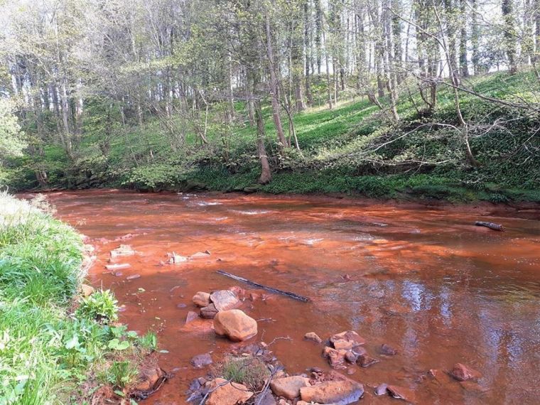
As well as methane (‘fire damp’), CO2 (‘choke damp’) and roof collapse, one of the main hazards of coal mining is flooding by groundwater. When operational, before the Conservative governments of the 1980s and early 90s set about destroying deep-coal mining in Britain, all mines had massive pumps to remove water from their deepest levels or ‘sumps’. It is hazardous stuff, being highly acidic and rich in dissolved metals – including arsenic in some areas – as well as being warm: a low-temperature hydrothermal fluid. In many cases such water seeps to the surface from the now flooded mine workings, and precipitates brightly coloured iron hydroxides. Most of the abandoned British coalfields are plagued by such minewater escaping to the surface. Untreated it contaminates surface water, soils and sediments, posing threats to vegetation, wild life and people. Yet, it has considerable potential as a heat source, especially for community heating systems based on large-scale heat pumps (Farr, G. et al. 2020. The temperature of Britain’s coalfields. Quarterly Journal of Engineering Geology and Hydrogeology, v. 54, article qjegh2020-109; DOI: 10.1144/qjegh2020-109).

Pollution of South Esk river near Edinburgh by water from old coal-mine workings (Credit: EdinburghLive, 11 June 2020)

For decades, geothermal energy has been touted as a near-ideal renewable, carbon-free resource, using natural hot-spring systems in volcanically active areas, such as Iceland and New Zealand, from areas of unusually high heat flow over highly radioactive granite intrusions or from very deep sedimentary aquifers as exploited in parts of the Paris Basin. But in Britain various optimistic projects have arisen and then faded away. All relied on pumping surface water down boreholes to depths that achieve high temperatures, returning it to the surface at around 60°C to the surface and then piping it to users: very expensive. About a quarter of the population live above the former coalfields of Britain. Around 2.2 million gigawatt hours of geothermal heat are currently stored in flooded mine workings, with the possibility of further expansion. The UK Coal Authority has about 40 minewater pumping stations aimed at reducing pollution, which remove 3,000 l s-1 at an average temperature of around 9-18°C. Expressed in terms of energy content this amounts to 63 MW if recovered. But this is just scratching the surface of the potential for large-scale district heating based on heat pumps, such as that planned at Seaham, County Durham to heat 1500 new homes. Community heating and wastewater treatment can be combined for all the former coal mining areas in Central Scotland, the North of England and Midlands and South Wales where population densities are still very high

See also: Lane, A.2021. How flooded coalmines could heat homes. BBC Future 7 July 2020. Taylor, M. 2021. Abandoned pits of former mining town fuel green revolution. The Guardian, 10 August 2021.

Is there a future for coal?

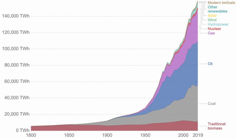
Burning coal is far and away the main culprit for elevated atmospheric CO2 and global climatic warming. That is a consequence of the Industrial Revolution and a mode of production that centres on the market value of commodities rather than their intrinsic usefulness and thus on the continual generation of profit. As the main original energy source for this capitalist mode, whose viability depends on incessant economic growth, world coal production grew at an exponential rate through the 19th and 20th centuries, as did its influence on global climate. Beginning in the 1920s, coal was joined by other carbon-based fossil fuels (oil and natural gas) in massively increasing energy and greenhouse-gas production. In the data there is little sign of an appetite to reduce this dependence on carbon burning, renewable energy output accounting today for only a few percent of the energy demands of capital. Although coal’s energy contribution is flattening off to be replaced by those of oil and gas, in terms of CO2 emissions it still dominates. That is because oil and gas are carbon-hydrogen compounds rather than almost pure carbon in the case of coal. Unless burning fossil fuels is outlawed and economic growth is drastically curtailed, we are set to live on a far warmer planet.

Growth in energy supply from different sources since 1800 CE (Credit: ourworldindata.org)

For various reasons coal is unique in a social sense. Every producing area has large communities who depend on mining for income. Britain now produces vastly less coal than it did up to the 1990s, with wholesale closure of underground mines. Since 1960 these communities have lost over half a million jobs in mining, let alone those in related industries and those that served mining communities. Three decades on from the last round of closures, those communities remain socially devastated in many respects. A huge amount of coal still lies beneath them. Can it make a come-back? A recent study suggests that perhaps it can, with diametrically opposite environmental consequences.

It seems that surfaces of coal particles are able to take-up and store gases, increasingly so as pressure increases. Miners faced the consequences of that in the form of adsorbed carbon dioxide and methane (‘choke damp’ and ‘fire damp’) that were released when coal was mined underground. Miners’ safety lamps (invented in 1815 by Humphry Davy) enable them to monitor the risks of suffocation by CO2 or explosion of CH4 when the lamps dim or flare, respectively. Engineers at Edith Cowan University in Perth, Western Australia, experimentally measured the amounts of hydrogen adsorbed by crushed coal at different pressures (Iglauer, S et al. 2021. Hydrogen adsorption on sub-bituminous coal: Implications for hydrogen geostorage. Geophysical Research Letters, v. 48, article 2021GL092976; DOI: 10.1029/2021GL092976). From surface atmospheric pressure to 40 times that, adsorption increases rapidly, especially for hydrogen (from 0.05 to 0.25 grams per kilogram). At higher pressures it rises less rapidly to about 0.6 g kg-1 at 100 times atmospheric pressure, which is equivalent to a depth of about 500 m in a sedimentary rock formation. At deeper levels hydrogen adsorption remains about the same.

The experimental results suggest that large amounts of hydrogen can be stored in coal at quite shallow depths. The potential storage in a ton of fractured coal is about 600 kg, equivalent to about 12 cubic metres of liquid hydrogen, but without the need for containment and refrigeration. In the absence of oxygen, such storage would be safe and long-term. If feasible from an engineering standpoint, underground storage of hydrogen in coal seams to overcome one of the current barriers to a hydrogen-based industrial economy through the storage of energy generated by carbon-free technologies, such as wind, wave, tidal and solar generation that operate at highly variable rates, not suited to energy use patterns. Effectively, coalfields could become giant ‘batteries’ without the need to mine vast amounts of elements, such as lithium, needed for conventional batteries; provided that a sustainable means of repeated hydrogen recovery can be devised. A central technology of a future ‘hydrogen economy’ is that of the fuel cell in which hydrogen and oxygen combine using a catalyst to generate electricity, without any combustion and emitting only water vapour.

‘Green’ metal mining?

A glance at statistics for the global consumption of any particular metal reveals much about the current unfairness of the world we live in. On a per capita basis, people in the developed, rich world use vastly more than do those in the less developed countries, on average. It is commonly said that in order for everyone to live in a fair world, the poor need more metals and other physical resources in order to match the living standards of the rich, or the wealthy will need to consume much less. A new factor in the equitability equation is the necessity to stave off CO2-induced global warming, largely through replacing energy from fossil fuels with that produced by a variety of ‘green’ sources. That carries with it another issue; the technologies for carbon-free energy generation, transmission, storage and use will consume a broad range of metals and other physical resources. These include cobalt and lithium, graphite, rare-earth elements and especially copper, whose annual production is set to soar.

Copper is particularly critical. If China alone fulfils its planned production of all-electric transportation, the demand for copper will over 2 billion tonnes requiring 119 years production at the current extraction rate of 20 Mt per year. The rush to electric cars has already forced copper demand above production, resulting in soaring prices on the world market. In the last year they have doubled, reaching US$10,000 per ton at the time ofwriting. Most metals are won by digging up their ores, often from considerable depths in the crust. Ores then have to be concentrated, smelted and the elemental metals refined. About 6 % of global energy is consumed by this process, adding CO2 and a variety of noxious gases to the atmosphere, let alone the stupendous amounts of uneconomic waste rock and polluted water. Copper is high up the list for environmental impact, being extracted from some of the world biggest mines. Like all physical resources, its extraction cannot be continued without further environmental deterioration. But is there a more sustainable way of extracting metals from the Earth?

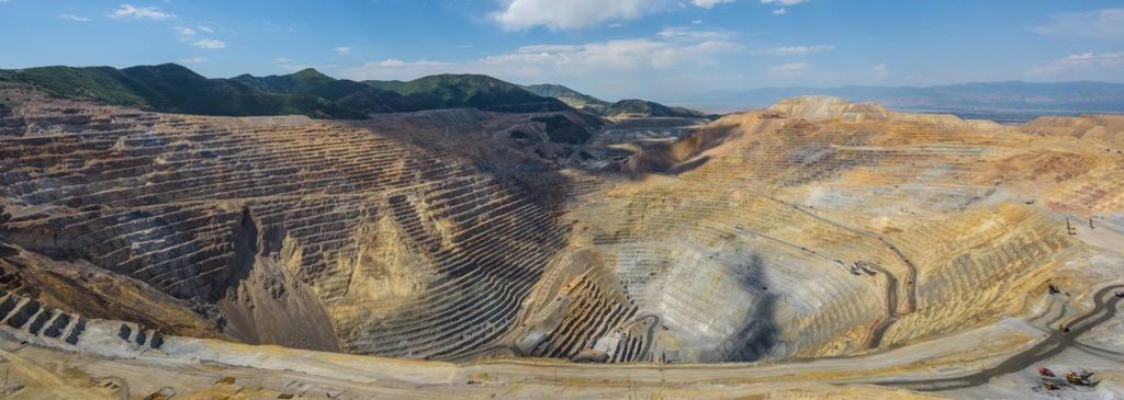
Bingham Canyon copper mine in Utah, USA; at 4.5 km diameter and 1.2 km depth it is the world’s largest excavation. (Credit: Mining Magazine)

Under the right chemical conditions many metals can be dissolved, so longs as fluids can pass through the ore. One example is the use of sodium cyanide solution (known as a lixiviant) to dissolve gold from low-grade ore: so-called ‘heap leaching’. But this is done at the surface, either using newly crushed ore from an excavation or waste from earlier mining that could not extract fine-grained gold. A similar approach uses bacteria whose metabolism involves oxidation of sulfide ore minerals, resulting in chemical reactions that liberate their desirable metal content to solution in water. If buried orebodies are fractured in situ this kind of leaching will supposedly transform metal production, in an analogous fashion to fracking for gas and oil. Like fracking, current operations that involve both forms of hydrometallurgy generate highly toxic fluids, and in many cases extract only a fraction of the target metal. But a novel alternative has just emerged, which involves leaching based on electrical means (Martens, E. and 9 others 2021. Toward a more sustainable mining future with electrokinetic in situ leaching. Science Advances, v. 7, article eabf9971; DOI: 10.1126/sciadv.abf9971). It isn’t totally new, for it uses the same chemistry as in heap leaching. However, it does not involve shattering the orebody at depth. Instead, low-voltage currents are passed through the orebody which induce a lixiviant to migrate through the rock, along mineral-grain boundaries rather than through fractures. Fluid movement becomes more efficient over time as the host rock is artificially ‘weathered’ thereby making it permeable. In effect, electrokinetic leaching creates a kind of hydrothermal system in reverse, by replacing the chemically reducing conditions of ore deposition with oxidising dissolution and transportation.

So far, the method has only been demonstrated through a small-scale test of concept using drill core samples of ore from a copper mine. Tests over a few days consumed more than half the grains of a copper ore mineral (chalcopyrite) present in the ore sample. So, it seems to work and astonishingly rapidly too. No doubt metal-mining companies, who are currently coining it hand-over-fist during a boom in metal prices, will beat a path to the doors of the team of researchers. But is it an economic proposition? They authors will soon find out … More important, if it is deployed widely will it increase the sustainability of metal mining? At first glance, yes: by removing the need for excavation of ore, liberation of ore-mineral grains by milling and their separation from valueless waste and many other aspects of beneficiation at the surface. Yet, the bottom line is that mining companies deploy their capital not so much to make ingots of useful metal but primarily to yield profits.  Speeding up metal extraction and thereby its supply to the world market could drive down the price that they can get for each tonne. Perversely, it is perceived shortages on metals and the resulting inflation of price that really yield bonanzas. My guess is that the industry will continue mining in the present manner, with all its lack of sustainability and environmental impact, for that very reason. The real way to reduce damage is to reduce demand for metals: do people in general really need more of them and the goods in which they are bound up in such vast amounts?

Indian groundwater shortage threatens food production

Farmers in India have been engaged in mass protests since September 2020. Their anger is directed at a series of laws introduced by the central government of Narendra Modi’s  Bharatiya Janata Party (BJP) that change farmers’ terms of trade. Agriculture in India also faces a future of reduced availability of groundwater on which farmers have become increasingly dependent, especially in the vast alluvial plains of the Ganges river system. The twin satellites of the Gravity Recovery  and Climate Experiment (GRACE), which chart changes in mass beneath the Earth’s surface, detected a major change in gravity over 3 million km2 of India’s largest area of agriculture in the northwestern Gangetic plains (Rodell, M. et al. 2009. Satellite-based estimates of groundwater depletion in India. Nature, v. 460, p.999-1002; DOI: 10.1038/nature08238). The data suggested a loss between 2002 and 2008 of around 109 cubic kilometres of water from the aquifers that support regional irrigation and the livelihoods of about 114 million people (see NASA summary). The loss of water and decline in well-water levels have continued since then.

Colour-coded GRACE data  from 2002 to 2008 showing the estimated drawdown in water levels in wells in NW India and NE Pakistan during this period. Green to dark-red colours indicate from 0 to 12 metres of decline (credit: Trent Schindler and Matt Rodell, NASA)

A recent comprehensive survey (Jain, M. and 8 others 2021. Groundwater depletion will reduce cropping intensity in India. Science Advances, v. 9, article eabd2849; DOI: 10.1126/sciadv.abd2849) uses satellite image and census data to document the actual changes in winter crops (those most dependent on irrigation) over the period 2001 to 2012. It roughly measures the realities of the unsustainable extraction of groundwater indicated by GRACE from 2002 to 2008. The study projects an average reduction of 20% in winter cropping across the whole of India, with some of the worst-hit areas being likely to experience a 68% loss. The dominant supplies of irrigation water are from countless tube wells and systems of canals supplied by dams or rivers. India has witnessed impressive gains in food production in the last half century, thanks to rapid and continuing growth in the number of tube wells driven by individual farmers. The livelihoods of about 600 million people depend on agriculture. There is no prospect of substituting either form of irrigation to maintain current levels of production. If increased canal supply was used to replace well water and reduce groundwater depletion, cropping intensity would still decline, albeit at about half the projected rate; however, that doesn’t take into account unpredictable droughts in surface water accumulation and movement.

Faced with this situation, it is hardly surprising that farmers fear for their families future and react massively to state intervention in their marketing and crop storage strategies.

For a wider context to the Indian agricultural crisis see also: The ecological roots of India’s farming crisis (Deutche Welle, 1 February, 2021)

Diamonds and the deep carbon cycle

When considering the fate of the element carbon and CO2, together with all their climatic connotations, it is easy to forget that they may end up back in the Earth’s mantle from which they once escaped to the surface. In fact all geochemical cycles involve rock, so that elements may find their way into the deep Earth through subduction, and they could eventually come out again: the ‘logic’ of plate tectonics. Teasing out the various routes by which carbon might get to mantle is not so easily achieved. Yet one of the ways it escapes is through the strange magma that once produced kimberlite intrusions, in the form of pure-carbon crystals of diamond that kimberlites contain. A variety of petrological and geochemical techniques, some hinging on other minerals that occur as inclusions, has allowed mineralogists to figure out that diamonds may form at depths greater than about 150 km. Most diamonds of gem quality formed in unusually thick lithosphere beneath the stable, and relatively cool blocks of ancient continental crust known as cratons, which extends to about 250 km. But there are a few that reflect formation depths as great as 800 km that span two major discontinuities in the mantle (at 410 and 660 km depth). These transition zones are marked by sudden changes in seismic speed due to pressure-induced transformations in the structure and density of the main mantle mineral, olivine.

Diamond crystal containing a garnet and other inclusions (Credit: Stephen Richardson, University of Cape Town, South Africa)

Carbon-rich rocks that may be subducted are not restricted to limestones and carbon-rich mudstones. Far greater in mass are the basalts of oceanic crust. Not especially rich in carbon when they crystallised as igneous rocks, their progress away from oceanic spreading centres exposes them to infiltration by ocean water. Once heated, aqueous fluids cause basalts to be hydrothermally altered. Anhydrous feldspars, pyroxenes and olivines react with the fluids to break down to hydrated-silicate clays and dissolved metals. Dissolved carbon dioxide combines with released calcium and magnesium to form pervasive carbonate minerals, often occupying networks of veins. So there has been considerable dispute as to whether subducted sediments or igneous rocks of the oceanic crust are the main source of diamonds. Diamonds with gem potential form only a small proportion of recovered diamonds. Most are only saleable for industrial uses as the ultimate natural abrasive and so are cheaply available for research. This now centres on the isotopic chemistry of carbon and nitrogen in the diamonds themselves and the various depth-indicating silicate minerals that occur in them as minute inclusions, most useful being various types of garnet.

The depletion of diamonds in ‘heavy’ 13C once seemed to match that of carbonaceous shales and the carbonates in fossil shells, but recent data from carbonates in oceanic basalts reveals similar carbon, giving three possibilities. Yet, when their nitrogen-isotope characteristics are taken into account, even diamonds that formed at lithospheric depths do not support a sedimentary source (Regier, M.E. et al. 2020. The lithospheric-to-lower-mantle carbon cycle recorded in superdeep diamonds. Nature, v. 585, p. 234–238; DOI: 10.1038/s41586-020-2676-z). That leaves secondary carbonates in subducted oceanic basalts as the most likely option, the nitrogen isotopes more reminiscent of clays formed from igneous minerals by hydrothermal processes than those created by weathering and sedimentary deposition. However, diamonds with the deepest origins – below the 660 km mantle transition zone – suggest yet another possibility, from the oxygen isotopes of their inclusions combined with those of C and N in the diamonds. All three have tightly constrained values that most resemble those from pristine mantle that has had no interaction with crustal rocks. At such depths, unaltered mantle probably contains carbon in the form of metal alloys and carbides. Regier and colleagues suggest that subducted slabs reaching this environment – the lower mantle – may release watery fluids that mobilise carbon from such alloys to form diamonds. So, I suppose, such ultra-deep diamonds may be formed from the original stellar stuff that accreted to form the Earth and never since saw the ‘light of day’.

‘Mud, mud, glorious mud’

Earth is a water world, which is one reason why we are here. But when it comes to sedimentary rocks, mud is Number 1. Earth’s oceans and seas hide vast amounts of mud that have accumulated on their floors since Pangaea began to split apart about 200 Ma ago during the Early Jurassic. Half the sedimentary record on the continents since 4 billion years ago is made of mudstones. They are the ultimate products of the weathering of crystalline igneous rocks, whose main minerals – feldspars, pyroxenes, amphiboles, olivines and micas, with the exception of quartz – are all prone to breakdown by the action of the weakly acidic properties of rainwater and the CO2 dissolved in it. Aside from more resistant quartz grains, the main solid products of weathering are clay minerals (hydrated aluminosilicates) and iron oxides and hydroxides. Except for silicon, aluminium and ferric iron, most metals end up in solution and ultimately the oceans.  As well as being a natural product of weathering, mud is today generated by several large industries, and humans have been dabbling in natural muds since the invention of pottery some 25 thousand years ago.  On 21 August 2020 the journal Science devoted 18 pages to a Special Issue on mud, with seven reviews (Malakoff, D. 2020. Mud. Science, v. 369, p. 894-895; DOI: 10.1126/science.369.6506.894).

Mud carnival in Brazil (Credit: africanews.com)

The rate at which mud accumulates as sediment depends on the rate at which erosion takes place, as well as on weathering. Once arable farming had spread widely, deforestation and tilling the soil sparked an increase in soil erosion and therefore in the transportation and deposition of muddy sediment. The spurt becomes noticeable in the sedimentary record of river deltas, such as that of the Nile, about 5000 years ago. But human influences have also had negative effects, particularly through dams. Harnessing stream flow to power mills and forges generally required dams and leats. During medieval times water power exploded in Europe and has since spread exponentially through every continent except Antarctica, with a similar growth in the capacity of reservoirs. As well as damming drainage these efforts also capture mud and other sediments. A study of drainage basins in north-east USA, along which mill dams quickly spread following European colonisation in the 17th century, revealed their major effects on valley geomorphology and hydrology (see: Watermills and meanders; March 2008). Up to 5 metres of sediment build-up changed stream flow to an extent that this now almost vanished industry has stoked-up the chances of major flooding downstream and a host of other environmental changes. The authors of the study are acknowledged in one Mud article (Voosen, P. 2020. A muddy legacy. Science, v. 369, p. 898-901; DOI: 10.1126/science.369.6506.898) because they have since demonstrated that the effects in Pennsylania are reversible if the ‘legacy’ sediment is removed. The same cannot be expected for truly vast reservoirs once they eventually fill with muds to become useless. While big dams continue to function, alluvium downstream is being starved of fresh mud that over millennia made it highly and continuously productive for arable farming, as in the case of Egypt, the lower Colorado River delta and the lower Yangtze flood plain below China’s Three Gorges Dam.

Mud poses extreme risk when set in motion. Unlike sand, clay deposits saturated with water are thixotropic – when static they appear solid and stable but as soon as they begin to move en masse they behave as a viscous fluid. Once mudflows slow they solidify again, burying and trapping whatever and whomever they have carried off. This is a major threat from the storage of industrially created muds in tailings ponds, exemplified by a disaster at a Brazilian mine in 2019, first at the site itself and then as the mud entered a river system and eventually reached the sea. Warren Cornwall explains how these failures happen and may be prevented (Cornwall, W. 2020. A dam big problem.  Science, v. 369, p. 906-909; DOI: 10.1126/science.369.6506.906). Another article in the Mud special issue considers waste from aluminium plants (Service, R.F. 2020. Red alert. Science, v. 369, p. 910-911; DOI: 10.1126/science.369.6506.910). The main ore for aluminium is bauxite, which is the product of extreme chemical weathering in the tropics. The metal is smelted from aluminium hydroxides formed when silica is leached out of clay minerals, but this has to be separated from clay minerals and iron oxides that form a high proportion of commercial bauxites, and which are disposed of in tailings dams. The retaining dam of such a waste pond in Hungary gave way in 2010, the thixotropic red clay burying a town downstream to kill 10 people. This mud was highly alkaline and inflicted severe burns on 150 survivors. Service also points out a more positive aspect of clay-rich mud: it can absorb CO2 bubbled through it to form various, non-toxic carbonates and help draw down the greenhouse gas.

Muddy sediments are chemically complex, partly because their very low permeability hinders oxygenated water from entering them: they maintain highly reducing conditions. Because of this, oxidising bacteria are excluded, so that much of the organic matter deposited in the muds remains as carbonaceous particles. They store carbon extracted from the atmosphere by surface plankton whose remains sink to the ocean floor. Consequently, many mudrocks are potential source rocks for petroleum. Although they do not support oxygen-demanding animals, they are colonised by bacteria of many different kinds. Some – methanogens – break down organic molecules to produce methane. The metabolism of others depends on sulfate ions in the trapped water, which they reduce to sulfide ions and thus hydrogen sulfide gas: most muds stink. Some of the H2S reacts with metal ions, to precipitate sulfide minerals, the most common being pyrite (FeS2). In fact a significant proportion of the world’s copper, zinc and lead resources reside in sulfide-rich mudstones: essential to the economies of Zambia and the Democratic Republic of Congo. But there are some strange features of mud-loving bacteria that are only just emerging. The latest is the discovery of bacteria that build chains up to 5 cm long that conduct electricity (Pennisi, E. 2020. The mud is electric. Science, v. 369, p. 902-905; DOI: 10.1126/science.369.6506.902). The bacterial ‘nanowires’ sprout from minute pyrite grains, and transfer electrons released by oxidation of organic compounds, effectively to catalyse sulfide-producing reduction reactions. NB Oxygen is not necessary for oxidation as its chemistry involves the loss of electrons, while reduction involves a gain of electrons, expressed by the acronym OILRIG (oxidation is loss, reduction is gain). It seems such electrical bacteria are part of a hitherto unsuspected chemical ecosystem that helps hold the mud together as well as participating in a host of geochemical cycles. They may spur an entirely new field of nano-technology, extending, bizarrely, to an ability to generate electricity from moisture in the air.

If you wish to read these reviews in full, you might try using their DOIs at Sci Hub.

Can rock weathering halt global warming?

The Lockdown has hardly been a subject for celebration, but there have been two aspects that are, to some extent, a comfort: the trickle of road traffic and the absence of convection trails. As a result the air is less polluted and much clearer, and the quietness, even in cities, has been almost palpable. Wildlife seems to have benefitted and far less CO2 has been emitted. Apart from the universal tension of waiting for one of a host of potential Covid-19 symptoms to strike and the fact that the world economy is on the brink of the greatest collapse in a century, it is tempting to hope that somehow business-as-usual will remain this way. B*gger the gabardine rush to work and the Great Annual Exodus to ‘abroad’. The crisis in the fossil fuel industry can continue, as far as I am concerned, But then, of course, I am retired, lucky to have a decent pension and live rurally. Despite the health risks, however, global capital demands that business-as-it-was must return now. A planet left to that hegemonic force has little hope of staving off anthropogenic ecological decline. But is there a way for capital to ‘have its cake and eat it’? Some would argue that there are indeed technological fixes. Among them is sweeping excess of the main greenhouse gas ‘under the carpet’ by burying it. There are three main suggestions: physically extracting CO2 where it is emitted and pumping it underground into porous rocks; using engineered biological processes in the oceans to take carbon into planktonic carbohydrate or carbonate shells and disposing the dead remains in soil or ocean-floor sediments; enhancing and exploiting the natural weathering of rock. The last is the subject of a recent cost-benefit analysis (Beerling, D.J. and 20 others 2020. Potential for large-scale CO2 removal via enhanced rock weathering with croplands. Nature, v. 583, p. 242–248; DOI: 10.1038/s41586-020-2448-9).

Carbon dioxide in the rock cycle (Credit: Skeptical Science, in Wikipedia)

Research into the climatic effects of rock weathering has a long history, for it represents one of the major components of the global carbon cycle, as well as the rock cycle. Natural chemical weathering is estimated to remove about a billion metric tons of atmospheric carbon annually. That is because the main agent of weathering is the slightly acid nature of rainwater, which contains dissolved CO2 in the form of carbonic acid (H2CO3). This weak acid comprises hydrogen ions (H+), which confer acidity, that are released by the dissolution of CO2 in water, together with HCO3ions (bicarbonate, now termed hydrogen carbonate). During weathering the hydrogen ions break down minerals in rock. This liberates metals that are abundant in the silicate minerals that make up igneous rocks – predominantly Na, Ca, K, and Mg – as their dissolved ions, leaving hydrated aluminium silicates (clay minerals) and iron oxides as the main residues, which are the inorganic basis of soils. The dissolved metals and bicarbonate ions may ultimately reach the oceans. However, calcium and magnesium ions in soil moisture readily combine with bicarbonate ions to precipitate carbonate minerals in the soil itself, a process that locks-in atmospheric carbon. Another important consequence of such sequestration is that it may make the important plant nutrient magnesium – at the heart of chlorophyll – more easily available and it neutralises any soil acidity built-up by continuous agriculture.  But carbon sequestration naturally achieved by weathering amounts to only about a thirtieth of that emitted by the burning of fossil fuels, and we know that is incapable of coping with the build-up of anthropogenic CO2 in the atmosphere: it certainly has not since the start of the Industrial Revolution.

What could chemical weathering do if it was deliberately enhanced?  One of the most common rocks, basalt, is made up of calcium-rich feldspar and magnesium-rich pyroxene and olivine. In finely granulated form this mix is particularly prone to weathering, and the magnesium released would enrich existing soil as well as drawing down CO2. Hence the focus by David Beerling and his British, US and Belgian colleagues on systematic spreading of ground-up basalt on cropland soils, in much the same way as crushed limestone is currently applied to reverse soil acidification. It is almost as cheap as conventional liming, with the additional benefit of fertilising: it would boost to crop yields. The authors estimate that removal of a metric ton of CO2 from the atmosphere by this means would cost between US$ 55 to 190, depending on where it was done. One of their findings is that the three largest emitters of carbon dioxide – China, the US and India – happen to have the greatest potential for carbon sequestration by enhanced weathering. Incidentally, increased fertility also yields more organic waste that itself could be used to increase the actual carbon content of soils, if converted through pyrolysis to ‘biochar’ .

It all sounds promising, almost ‘too good to be true’. The logistics that would be needed and the carbon emissions that the sheer mass of rock to be finely ground and then distributed would entail, for as long as global capital continues to burn fossil fuels, are substantial, as the authors admit. The grinding would have to be far more extreme than the production of igneous-rock road aggregate. Basalt or related rock is commonly used for resurfacing motorways, not especially well known for degrading quickly to a clay-rich mush. It would probably have to be around the grain size achieved by milling to liberate ore minerals in metal mines, or to produce the feedstock for cement manufacture: small particles create a greater surface area for chemical reactions. But there remains the issue of how long this augmented weathering would take to do the job: its efficiency. Experimental weathering to test this great-escape hypothesis is being conducted by a former colleague of mine, using dust from an Irish basalt quarry to coat experimental plots of a variety of soil types. After two months Mg and Ca ions were indeed being released from the dust, and tiny fragments of olivine, feldspar and pyroxene do show signs of dissolution. Whether this stems from rainwater – the main objective – or from organic acids and bacteria in the soils is yet to be determined. No doubt NASA is doing much the same to see if dusts that coat much of Mars can be converted into soils  Beerling et al. acknowledge that the speed of weathering is a major uncertainty. Large-scale field trials seem some way off, and are likely to be plagued by cussedness! Will farmers willingly change their practices so dramatically?

See also: Lehmann, J & Possinger, A. 2020. Removal of atmospheric CO2 by rock weathering holds promise for mitigating climate change. Nature, v. 583, p. 204-205; DOI: 10.1038/d41586-020-01965-7

Note (added 15 July 2020): Follower Walter Pohl has alerted me to an interesting paper on using ultramafic rocks in the same way (Kelemen, P.B. et al. 2020. Engineered carbon mineralization in ultramafic rocks for COremoval from air: Review and new insights. Chemical Geology, v.  550, Article 119628; DOI:10.1016/j.chemgeo.2020.119628). Walter’s own blog contains comments on the climatic efficacy of MgCO3 (magnesite) formed when olivine is weathered.

Sedimentary deposits of the ‘Anthropocene’

Economic activity since the Industrial Revolution has dug up rock – ores, aggregate, building materials and coal. Holes in the ground are a signature of late-Modern humanity, even the 18th century borrow pits along the rural, single-track road that passes the hamlet where I live. Construction of every canal, railway, road, housing development, industrial estate and land reclaimed from swamps and sea during the last two and a half centuries involved earth and rock being pushed around to level their routes and sites. The world’s biggest machine, aside from CERN’s Large Hadron Collider near Geneva, is Hitachi’s Bertha the tunnel borer (33,000 t) currently driving tunnels for Seattle’s underground rapid transit system. But the record muck shifter is the 14,200 t MAN TAKRAF RB293 capable of moving about 220,000 t of sediment per day, currently in a German lignite mine. The scale of humans as geological agents has grown exponentially. We produce sedimentary sequences, but ones with structures that are very different from those in natural strata. In Britain alone the accumulation of excavated and shifted material has an estimated volume six times that of our largest natural feature, Ben Nevis in NW Scotland. On a global scale 57 billion t of rock and soil is moved annually, compared with the 22 billion t transported by all the world’s rivers. Humans have certainly left their mark in the geological record, even if we manage to reverse  terrestrial rapacity and stave off the social and natural collapse that now pose a major threat to our home planet.

A self propelled MAN TAKRAF bucketwheel excavator (Bagger 293) crossing a road in Germany to get from one lignite mine to another. (Credit: u/loerez, Reddit)

The holes in the ground have become a major physical resource, generating substantial profit for their owners from their infilling with waste of all kinds, dominated by domestic refuse. Unsurprisingly, large holes have become a dwindling resource in the same manner as metal ores. Yet these stupendous dumps contain a great deal of metals and other potentially useful material awaiting recovery in the eventuality that doing so would yield a profit, which presently seems a remote prospect. Such infill also poses environmental threats simply from its composition which is totally alien compared with common rock and sediment. Three types of infill common in the Netherlands, of which everyone is aware, have recently been assessed (Dijkstra, J.J. et al. 2019. The geological significance of novel anthropogenic materials: Deposits of industrial waste and by-products. Anthropocene, v. 28, Article 100229; DOI: 10.1016/j.ancene.2019.100229). These are: ash from the incineration of household waste; slags from metal smelting; builders’ waste. What unites them, aside from their sheer mass, is the fact that are each products of high-temperature conditions: anthropogenic metamorphic rocks, if you like. That makes them thermodynamically unstable under surface conditions, so they are likely to weather quickly if they are exposed at the surface or in contact with groundwater. And that poses threats of pollution of soil-, surface- and groundwater

All are highly alkaline, so they change environmental pH. Ash from waste incineration is akin to volcanic ash in that it contains a high proportion of complex glasses, which easily break down to clays and soluble products. Curiously, old dumps of ash often contain horizons of iron oxides and hydroxides, similar to the ‘iron pans’ in peaty soils. They form at contacts between oxidising and reducing conditions, such as the water table or at the interface with natural soils and rocks. Soluble salts of a variety of trace elements may accumulate, such copper, antimony and molybdenum. Slags not only contain anhydrous silicates rich in the metals of interest and other trace metals, which on weathering may yield soluble chromium and vanadium, but they also have high levels of calcium-rich compounds from the limestone flux used in smelting, i.e. agents able to create high alkalinity. Portland cement, perhaps the most common material in builders’ waste, is dominated by hydrated calcium-aluminium silicates that break-down if the concrete is crushed, again with highly alkaline products. Another component in demolition debris is gypsum from plaster, which can be a source of highly toxic hydrogen sulfide gas generated in anaerobic conditions by sulfate-sulfide reducing bacteria.

Ancient oil migration

In order for petroleum deposits to form, the first requirement is a source of abundant hydrocarbons, most usually from a mudstone that was deposited under highly reducing conditions. In such an environment dead organic matter can accumulate without complete decay and oxidation to form a source rock or black shale. The next step comes from burial and heating until the dead matter matures to release liquid and gaseous hydrocarbons. In turn these fluids, along with heated water, must leave the impermeable source rock and migrate through more porous and permeable strata, such as sandstone or limestone reservoir rocks. Either they reach the surface to escape or become trapped in some kind of geological structure. In migrating, the hydrocarbons induce reducing condition in the rocks through which they flow, often bleaching them as the colouring agents based on insoluble iron-3 compounds are reduced to iron-2 that dissolves and is carried out of the system along with the hydrocarbons.

Throughout the Precambrian, the Earth was lacking in free or dissolved oxygen, even after the Great Oxidation Event at around 2.4 to 2.1 billion years ago; ideal conditions for the formation of black-shale source rocks. And indeed there are huge volumes of them going back to the Palaeoarchaean Era (>3.25 Ga). The Earth’s heat flow having be greater then, due to less decay of radioactive heat-producing elements in the mantle, petroleum must have been generated in volumes at least as large as that released during the Phanerozoic. Yet there are few oilfields of Precambrian age, and geologists usually don’t bother looking for oil in very ancient rocks, largely because the older a rock sequence is the more likely it has been deeply buried and heated above the temperature at which oil breaks down into hydrocarbon gases (~130°C), which in turn are destroyed above about 250°C. Moreover, many such ancient rocks have generally been deformed by many phases of brittle tectonic processes that formed zones of fracturing that give lines of easy escape for pressurised fluids.

gunflint
Interleaved chert (white) and ironstone of the Palaeoproterozoic Gunflint Iron Formation of Ontario, Canada and Minnesota, USA.

So, looking for telltale signs of oil formation and migration in Precambrian strata is pretty much a matter of academic curiosity. Solid, bituminous hydrocarbons granules and veins are not uncommon in Precambrian sediments, although their relationships do not rule out later introduction into ancient rocks. Birger Rasmussen of the University of Western Australia has been tracking down such signs for over 30 years, his best known discovery – in 2005 – being in Archaean rocks (3.2 to 2.6 Ga) of the Pilbara craton in Western Australia. Recently, he and Janet Muhling of the same institution reported stunning evidence of migration in the Palaeoproterozoic Era (Rasmussen, B. & Muhling, J.R. 2019. Evidence for widespread oil migration in the 1.88 Ga Gunflint Formation, Ontario, Canada. Geology, v. 47, p. 899-903; DOI: 10.1130/G46469.1). The sedimentary unit is a banded iron formation containing interleaved cherts (famous for their content of some of the oldest incontrovertible microfossils), a granular variant of which is pervaded by solid bitumen in both granules and former pore spaces. This is interpreted as the result of oil migration during the actual cementation of the ironstone by silica; i.e. during diagenesis below the seabed rather than through solid sedimentary rock. Bitumen also fills later fractures. Rasmussen and Muhling consider the most likely scenario for this undoubted Palaeoproterozoic reservoir to have formed. They conclude that it coincided with the tectonic burial of the BIF basin beneath an exotic thrust block about 20 Ma after its formation. This generated petroleum from older source rocks, remote from the site of BIF deposition, that migrated away and up-dip from the thrust belt following the unconsolidated BIF formation.

UK shale gas: fracking potential dramatically revised downwards

In 2013, much to the joy of the British government and the fracking industry, the British Geological Survey (BGS) declared that there was likely to be between 24 and 68 trillion m3 (TCM) of gas available to fracking ventures in the Carboniferous Bowland Shale, the most promising target in Britain. That is equivalent to up to about 90 years’ supply at the current UK demand for natural gas.  The BGS estimate was based on its huge archives of subsurface geology, including that of the Bowland Shale; they know where the rock is present and how much there is. But their calculations of potential gas reserves used data on the gas content of shales in the US where fracking has been booming for quite a while. Fracking depends on creating myriad cracks in a shale so that gas can escape what is an otherwise impermeable material.

Bowland Shale 1
Areas in Britain underlain by the Bowland Shale formation (credit: British Geological Survey)

How much gas might be available from a shale depends on its content of solid hydrocarbons (kerogen) and whether it has thermally matured and produced gas that remains locked within the rock. So a shale may be very rich in kerogen, but if it has not been heated to ‘maturity’ during burial it may contain no gas at all, and is therefore worthless for fracking. Likewise, a shale from which the gas has leaked away over millions of years. A reliable means of checking has only recently emerged. High-pressure water pyrolysis (HPWP) mimics the way in which oil and gas are generated during deep burial and then expelled as once deep rock is slowly uplifted (Whitelaw, P. et al. 2019. Shale gas reserve evaluation by laboratory pyrolysis and gas holding capacity consistent with field data. Nature Communications, v. 10, article 3659; DOI: 10.1038/s41467-019-11653-4). The authors from the University of Nottingham, BGS and a geochemical consulting company show that two samples of the Bowland Shale are much less promising than originally thought. Based on the HPWP results, it seems that the Bowland Shale as a whole may have gas reserves of only around 0.6 TCM of gas that may be recoverable from the estimated 4 TCM of gas that may reside in the shale formation as a whole. This is ‘considerably below 10 years supply at the current [UK] consumption’.

Unsurprisingly, the most prominent of the fracking companies, Cuadrilla, have dismissed the findings brusquely, despite having published analyses of other samples that consistent with results in this paper. Opinion in broader petroleum circles is that the only way of truly putting a number to potential reserves is to drill and frack many wells … The British government may well have a collective red face only a week after indicating that they were prepared to review regulation of fracking, which currently forces operations to stop if it causes seismic events above magnitude 0.5 on the Richter scale. A spokesperson for Greenpeace UK said that, ‘Fracking is our first post-truth industry, where there is no product, no profit and no prospect of either.’

See also: McGrath, M. 2019. Fracking: UK shale reserves may be smaller than previously estimated. (BBC News 20 August); Ambrose, J. 2019. Government’s shift to relax shale gas fracking safeguards condemned (Guardian 15 August); Fracking in the UK; will it happen? (Earth-logs June 2014)

Ecological hazards of ocean-floor mining

Spiralling prices for metals on the world market, especially those that are rare and involved in still-evolving technologies, together with depletion of onshore, high-grade reserves are beginning to make the opportunity of mining deep, ocean-floor resources attractive. By early 2018, fifteen companies had begun detailed economic assessment of one of the most remote swathes of the Pacific abyssal plains. In April 2018 (How rich are deep-sea resources?) I outlined the financial attractions and the ecological hazards of such ventures: both are substantial, to say the least. In Japan’s Exclusive Economic Zone (EEZ) off Okinawa the potential economic bonanza has begun, with extraction from deep-water sulfide deposits of zinc equivalent to Japan’s annual demand for that metal, together with copper, gold and lead. One of the most economically attractive areas lies far from EEZs, beneath the East Pacific Ocean between the Clarion and Clipperton transform faults. It is a huge field littered by polymetallic nodules, formerly known as manganese nodules because Mn is the most abundant in them. A recent article spelled out the potential environmental hazards which exploiting the resources of this region might bring (Hefferman, O. 2019. Seabed mining is coming – bringing mineral riches and fears of epic extinctions. Nature, v. 571, p. 465-468; DOI: 10.1038/d41586-019-02242-y).

ocean floor resources
The distribution of potential ocean-floor metal-rich resources (Credit: Hefferman 2019)

Recording of the ecosystem on the 4 km deep floor of the Clarion-Clipperton Zone (CCZ) began in the 1970s. It is extraordinarily diverse for such a seemingly hostile environment. Despite its being dark, cold and with little oxygen, it supports a rich and unique diversity of more than 1000 species of worms, echinoderms, crustaceans, sponges, soft corals and a poorly known but probably huge variety of smaller animals and microbes inhabiting the mud itself. In 1989, marine scientists simulated the effect on the ecosystem of mining by using an 8-metre-wide plough harrow to break up the surface of a small plot. A plume of fine sediment rained down to smother the inhabitants of the plot and most of the 11 km2 surrounding it. Four subsequent visits up to 2015 revealed that recolonisation by its characteristic fauna has been so slow that the area has not recovered from the disturbance after three decades.

The International Seabed Authority (ISA), with reps from 169 maritime member-states, was created in 1994 by the United Nations to encourage and regulate ocean-floor mining; i.e. its function seems to be ‘both poacher and gamekeeper’. In 25 years, the ISA has approved only exploration activities and has yet to agree on an environmental protection code, such is the diversity of diplomatic interests and the lack of ecological data on which to base it. Of the 29 approved exploration licences, 16 are in the CCZ and span about 20% of it, one involving British companies has an area of 55,000 km2. ISA still has no plans to test the impact of the giant harvesting vehicles needed for commercial mining, and its stated intent is to keep only 30% of the CCZ free of mining ‘to protect biodiversity’. The worry among oceanographers and conservationists is that ISA will create a regulatory system without addressing the hazards properly. Commercial and technological planning is well advanced but stalled by the lack of a regulatory system as well as wariness because of the huge start-up costs in an entirely new economic venture.

The obvious concern for marine ecosystems is the extent of disturbance and ecosystem impact, both over time and as regards scale. The main problem lies in the particles that make up ocean-floor sediments, which are dominated by clay-size particles. The size of sedimentary particles considered to be clays ranges between 2.0 and 0.06 μm. According to Stokes Law, a clay particle at the high end of the clay-size range with a diameter of 2 μm  has a settling speed in water of 2 μm s-1. The settling speed for the smallest clays is 1,000 time slower. So, even the largest clay particles injected only 100 m above the ocean floor would take 1.6 years to settle back to the ocean floor – if the water column was absolutely still. But even the 4,000 m deep abyssal plains are not at all stil, because of the ocean-water ‘conveyor belt’ driven by thermohaline circulation. An upward component of this flow would extend the time during which disturbed ocean-floor mud remains in suspension – if that component was a mere >2 μm s-1, even the largest clay particles would remain suspended indefinitely. Deepwater currents, albeit slow, would also disperse the plume of fines over much larger areas than those being mined. Moreover such turbidity pollution is likely to occur at the ocean surface as well, if the mining vessels processed the ore materials by washing nodules free of attached clay. Plumes from shipboard processing would be dispersed much further because of the greater speed of shallow currents. This would impact the upper and middling depths of the oceans that support even more diverse and, in the case of mid-depths poorly known, ecosystems Such plumes may settle only after decades or even centuries, if at all.

Processing on land, obviously, presents the same risk for near-shore waters. It may be said that such pollution could be controlled easily by settling ponds, as used in most conventional mines on land. But the ‘fines’ produced by milling hard ores are mainly silt-sized particles (2.0 to 60 μm) of waste minerals, such as quartz, whose settling speeds are proportional to the square of their diameter; thus a doubling in particle size results in four-times faster settling. The mainly clay-sized fines in deep-ocean ores would settle far more slowly, even in shallow ponds, than the rate at which they are added by ongoing ore processing; chances are, they would eventually be released either accidentally or deliberately

A mining code is expected in 2020, in which operating licences are likely to be for 30 years. Unlike the enforced allowance of environmental restoration once a land-based mining operation is approved, the sheer scale, longevity and mobility of fine-sediment plumes seem unlikely to be resolvable, however strong such environmental-protection clauses are for mining the ocean floor.

Frack me nicely?

‘There’s a seaside place they call Blackpool that’s famous for fresh air and fun’. Well, maybe, not any more. If you, dear weekender couples, lie still after the ‘fun’ the Earth may yet move for you. Not much, I’ll admit, for British fracking regulations permit Cuadrilla, who have a drill rig at nearby Preston New Road on the Fylde coastal plain of NW England, only to trigger earthquakes with a magnitude less than 0.5 on the Richter scale. This condition was applied after early drilling by Cuadrilla had stimulated earthquakes up to magnitude 3. To the glee of anti-fracking groups the magnitude 0.5 limit has been regularly exceeded, thereby thwarting Cuadrilla’s ambitions from time to time. Leaving aside the view of professional geologists that the pickings for fracked shale gas in Britain [June 2014] are meagre, the methods deployed in hydraulic fracturing of gas-prone shales do pose seismic risks. Geology, beneath the Fylde is about as simple as it gets in tectonically tortured Britain. There are no active faults, and no significant dormant ones near the surface that have moved since about 250 Ma ago; most of Britain is riven by major fault lines, some of which are occasionally active, especially in prospective shale-gas basins near the Pennines. When petroleum companies are bent on fracking they use a drilling technology that allows one site to sink several wells that bend with depth to travel almost horizontally through the target shale rock. A water-based fluid containing a mix of polymers and surfactants to make it slick, plus fine sand or ceramic particles, are pumped at very high pressures into the rock. Joints and bedding in the shale are thus forced open and maintained in that condition by the sandy material, so that gas and even light oil can accumulate and flow up the drill stems to the surface. Continue reading “Frack me nicely?”