Where is Mars’s water?

A delta at the edge of Jazero Crater on Mars; definite evidence that water once flowed into the crater. Colours show different minerals in the delta sediments (credit: Brown University)

Early in the exploration of Mars using orbiting imaging systems it was easy to be sceptical about evidence for water being present at or near the surface of the Red Planet. Resolution was poor and some claims seemed to be wishful thinking or a sort of astronautical agitprop. For instance, gullies on steep slopes appeared so sharp that they must be forming continually, otherwise Mars’s periodic huge dust storms would have muted them. Some scientists claimed that they were signs of flowing water and even presented pictures from different overpasses that showed changes in them, such as darkening and small shifts in microtopography, which may have resulted from flowing water. Because Mars has a mean surface temperature of about -50°C that seems unlikely; at such extremes in Antarctica spit at the ground and it lands as ice. Nonetheless a bit of special pleading that deeply buried ice in Martian sediments might melt because of pressure gave the idea some traction.

A far more plausible explanation for the active gulley formation is that loose fine sediment can flow in the manner of a liquid, as it does in sand dunes on Earth (see: First signs of liquid water on Mars? June 2000). Yet as remotely sensed image coverage expanded and its resolution improved (currently about 50 cm) masses of evidence for drainage networks, signs of catastrophic floods and even glaciers (The glaciers of Mars, July 2003) emerged. Huge areas of the planet bore witness to a period in its past history – 4.1 to 3.8 billion years (Ga) ago – when it was a warm and wet planet. It has even been suggested that the flat, low-elevation northern hemisphere was the bed of a former ocean, covering about a third of Mars to a depth of about a kilometre. Now the planet has a hyperarid surface and a very thin atmosphere dominated by CO2, a little nitrogen and argon but almost no water vapour (~0.03%). Its poles are covered by ice caps whose extents fluctuate seasonally. They each have a core of permanent water ice, and seasonally expand and contract due to formation and sublimation of dry ice made of solid CO2. So what happened to Mars’s once abundant water?

One long-held theory is that water and most of Mars’s original atmosphere escaped to space. A suggested mechanism is the photo-dissociation of water to hydrogen and oxygen. Mars’s gravity cannot prevent hydrogen escape, which would leave an excess of atmospheric oxygen. One thing in abundance on the Martian surface is oxygen combined in iron oxides (Fe2O3); hence its red coloration. This hematite may have formed during chemical weathering of surface rocks and sediments during the wet phase, which released Fe2+ ions that were immediately oxidised by the hyper-oxygenated atmosphere that resulted from photo-dissociation. But there is another plausible explanation …

The lake-bed sediments of Gale Crater on Mars from NASA’s Curiosity rover (credit: NASA/JPL, California Institute of Technology)

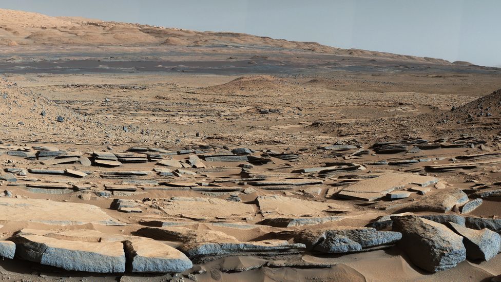
The much publicised successful landing of NASA’s Perseverance rover on 18 February 2021 was aimed at the small Jezero Crater, near the Martian equator. This contains an indisputable delta of a large drainage system that must once have filled the crater with a circular lake; a good place to seek out signs of early life, for which Perseverance is impressively equipped. Shortly afterwards there appeared a Research Article in Science (Scheller, E.L. et al. 2021. Long-term drying of Mars by sequestration of ocean-scale volumes of water in the crust. Science, Online research article eabc7717; DOI: 10.1126/science.abc7717) that examines the fate of the planet’s water. The authors estimate that by 3.0 Ga Mars’s surface had reached its current dry state. They model three processes – supply of water by volcanic degassing and its loss by atmospheric escape and chemical weathering of the Martian surface. The modelling was constrained by the ratio of deuterium (2H) to hydrogen inferred from meteorites believed to come from Mars and estimates by orbiting spacecraft of the current escape of hydrogen from the atmosphere. The latter is too slow to explain the huge loss of water between 4 and 3 Ga and subsequently. Addition of water from Mars’s mantle by volcanoes, even from the gigantic Olympus Mons, was far slower than on Earth because continuous plate tectonics was never achieved on Mars. Chemical weathering of the surface during Mars’s warm-wet phase formed abundant hydrated minerals as well as the hematite that gives the planet its characteristic hue. Water transport before 3 Ga moved clays and hydroxides etc to sedimentary basins, where they have remained undisturbed. On Earth, tectonics recycles sediments and their content of hydrated minerals into the mantle, eventually to regurgitate their water content through volcanism. On Mars, weathering and deposition has irreversibly locked-up between 30 and 99% of Mars’s original endowment of water in its ancient sedimentary crust.

That seems to be a ‘bit of a downer’ for ambitious prospects of terraforming Mars and making it a human escape destination. There are, however, some locations where water may be available in sufficient quantities to support some kind of permanent presence of small colonies, in the form of buried layers of ice, similar to permafrost (see: Ice cliffs on Mars, January 2018)

See also:  Carr, M.H. 2012. The fluvial history of Mars. Philosophical Transaction of the Royal Society (A), v. 370, p. 2193-2215; DOI: 10.1098/rsta.2011.0500.

The DNA of some old mammoths

The only positive outcome of the thawing of permafrost is that it exposes remains of ancient animals in a virtually intact state, most famously those of the woolly mammoth (Mammuthus primigenius). But not so well-preserved that anyone could be induced to feast on its thawed-out meat. Tales of select groups being served mammoth at banquets are almost certainly apocryphal, but several have tasted one, and found that the meat smelled rotten and tasted awful. Mammoth bones, being so large, are regularly found and most museums in the Northern Hemisphere display their enormous teeth. DNA from three species of these extinct elephants has been sequenced – North American and European woolly mammoths and the North American Columbian mammoth that thrived on the more temperate central plains. But they lived about 12 to 100 thousand years ago. Now genetic data are available from three molar teeth found in permafrost in the Chukochya river basin in northern Siberia. (van der Valk, T. and 21 others 2021. Million-year-old DNA sheds light on the genomic history of mammoths. Nature v.591, p. 265–269; DOI: 10.1038/s41586-021-03224-9).

Wooly mammoth tooth offered for sale at Christie’s in 2015, which fetched £2750 (Credit: Christie’s on-line archives)

The mammoth molars have been dated at 0.68, 1.0 and 1.2 Ma (conservative estimates), far older than a horse dated between 560 and 780 ka that yielded DNA several years back. The sheer mass of the teeth and the fact that they had been preserved in frozen soil shielded genetic material from complete breakdown, but it was nonetheless heavily degraded to fragments no more than 50 base pairs long. This presented a major challenge to the team of palaeogeneticists’ reconstruction of the three mammoths’ genomes. Comparing the genomes with those of far younger woolly mammoths and their closest living relatives, Indian elephants, reveals that the ancient beasts were cold-adapted and probably had woolly coats. Two of the genomes suggest direct ancestry to both later woolly mammoths, whereas the third – the oldest – can  be linked to the enormous Columbian mammoth (M. columbi) that lived on mid-American grasslands during the Late Pleistocene. During glacial maxima when sea levels were ~100 m lower than at present Siberian faunas could easily have migrated into and colonised the Americas, using the Beringia land bridge across the Bering Strait. An early migration by the oldest Siberian mammoth could have given rise to the Columbian mammoth, later crossings to the American woollies. In fact it seems that genetic strands from the two younger Siberian mammoths also entered the DNA of M. columbi at some stage in its evolution.

Interesting as these revelations are about Arctic ice-age megafaunas, finding human remains that predate a few 10’s of ka in permafrost is unlikely. Modern humans and  Neanderthals are known to have migrated through Arctic Siberia, and perhaps Denisovans did too. Some individuals may have been unfortunate enough to have fallen into boggy ground that froze to form permafrost. However, there is no evidence for older human species having moved north of about 40°N since the first Africans entered 1.8 Ma ago. In any case, without the protection of massive bones, human DNA would probably have degraded more quickly than did that of these old mammoths.

See also: Roca, A.L. 2021. Million-year-old DNA provides a glimpse of mammoth evolution. Nature, v. 591, p. 208-209; DOI: 10.1038/d41586-021-00348-w; Black, R. 2021. Oldest DNA sequenced yet comes from million-year-old mammoths (Smithsonian Magazine, 17 February, 2021)

News from the Chicxulub drilling project

Artist’s impression of an asteroid slamming into the shallow sea off the present Yucatán Peninsula about 65 Ma ago (Credit: Donald E. Davis of NASA)

Aimed at resolving the impact versus volcanism debate about the causes of the K-Pg mass extinction, the International Ocean Discovery Program (IODP) and International Continental Scientific Drilling Program (ICDP) began drilling into the focus of the Chicxulub impact structure off the Yucatán Peninsula, Mexico in 2016. The project recovered 830 m of rock core, of which  about 140 cm contained the boundary between tsunami deposits and the post-impact marine limestones of Danian Age (basal Palaeogene); as close as one can get to the moment when the asteroid hit the sea floor. That an impact close to the start of the Danian had taken place was first discovered from abnormally high concentrations of the platinum-group metal iridium (Ir), shocked mineral grains and glass spherules, among other anomalous materials, in 350 marine and terrestrial sections across the globe. If the Chicxulub crater contained similar features to these ‘smoking guns’ then the link might seem to be done and dusted. A report on the crucial few centimetres from the Chicxulub drill core shows this to be the case (Goderis, S. and 32 others 2021. Globally distributed iridium layer preserved within the Chicxulub impact structure. Science Advances, v. 9, article eabe3647; DOI: 10.1126/sciadv.abe3647).

Yet the boundary layer at Chicxulub could not have been emplaced at the instant of impact. The gigantic power involved would have flung debris outwards, including seawater as well as the rocks that were once at considerable depth below the seabed. Much in the manner of a stone falling into a pond molten crust would have rebounded from the initial strike to form an axial peak and a ringed basin. Likewise huge tsunamis would have rolled away from the impact, then to return and fill the new basin, perhaps several times. Some of the ejected debris would have reached low orbit in the form of pulverised rock and asteroid to remain there for a while before completely falling back to Earth. The core includes about 130 m of once partly molten debris (suevite) above more-or-less intact granitic basement. Only the top 3.5 m show signs of having been deposited in water; fine-grained, well-sorted and laminated suevite containing clasts of once molten material and even late-Cretaceous foraminifera tests, formed probably by the refilling of the impact basin during the backflow of tusunamis. A mere 3 cm of silt and clay just below marine limestones has yielded the characteristic high Ir and nickel concentrations. This Ir-rich layer also contains the earliest Palaeocene foraminifera.

Grains in the Ir-rich layer were the last to settle, the main question being ‘How long after the impact took place did that happen?’ Being very fine they are estimated to have fallen-out from suspension and circulation in the atmosphere over a period of up to a few decades. Coarser material below them would have taken no longer than a few weeks to years. Yet these estimates are based mainly on Stokes’ law governing particles of different sizes falling through a viscous fluid. Taking an empirical view based on actual rates of clay sedimentation in the ocean (~5 mm per thousand years) the Ir-rich layer may have been deposited over 6000 years. That is hardly the ‘instant of the impact’. But the timing does say something interesting about the return of life to the seas; in geological terms it was swift, if the forams are anything to go by. Since the tsunamis swept onto and drained the surrounding land masses a great deal of nutrient would have ended up in the sea awaiting organisms at the bottom of the food chain. Biomarker chemicals and trace fossils in the Ir-rich layer suggest  thriving bacterial communities, with forams, crustacea and larval fish.

The authors conclude ‘The clear association of the Ir anomaly within the Chicxulub impact structure and the recorded biotic response confirms the direct relationship between the impact event and the K-Pg mass extinction’. Whether that is accepted by those geoscientists with their eyes on the Deccan Trap hypothesis is not so certain …

Indian groundwater shortage threatens food production

Farmers in India have been engaged in mass protests since September 2020. Their anger is directed at a series of laws introduced by the central government of Narendra Modi’s  Bharatiya Janata Party (BJP) that change farmers’ terms of trade. Agriculture in India also faces a future of reduced availability of groundwater on which farmers have become increasingly dependent, especially in the vast alluvial plains of the Ganges river system. The twin satellites of the Gravity Recovery  and Climate Experiment (GRACE), which chart changes in mass beneath the Earth’s surface, detected a major change in gravity over 3 million km2 of India’s largest area of agriculture in the northwestern Gangetic plains (Rodell, M. et al. 2009. Satellite-based estimates of groundwater depletion in India. Nature, v. 460, p.999-1002; DOI: 10.1038/nature08238). The data suggested a loss between 2002 and 2008 of around 109 cubic kilometres of water from the aquifers that support regional irrigation and the livelihoods of about 114 million people (see NASA summary). The loss of water and decline in well-water levels have continued since then.

Colour-coded GRACE data  from 2002 to 2008 showing the estimated drawdown in water levels in wells in NW India and NE Pakistan during this period. Green to dark-red colours indicate from 0 to 12 metres of decline (credit: Trent Schindler and Matt Rodell, NASA)

A recent comprehensive survey (Jain, M. and 8 others 2021. Groundwater depletion will reduce cropping intensity in India. Science Advances, v. 9, article eabd2849; DOI: 10.1126/sciadv.abd2849) uses satellite image and census data to document the actual changes in winter crops (those most dependent on irrigation) over the period 2001 to 2012. It roughly measures the realities of the unsustainable extraction of groundwater indicated by GRACE from 2002 to 2008. The study projects an average reduction of 20% in winter cropping across the whole of India, with some of the worst-hit areas being likely to experience a 68% loss. The dominant supplies of irrigation water are from countless tube wells and systems of canals supplied by dams or rivers. India has witnessed impressive gains in food production in the last half century, thanks to rapid and continuing growth in the number of tube wells driven by individual farmers. The livelihoods of about 600 million people depend on agriculture. There is no prospect of substituting either form of irrigation to maintain current levels of production. If increased canal supply was used to replace well water and reduce groundwater depletion, cropping intensity would still decline, albeit at about half the projected rate; however, that doesn’t take into account unpredictable droughts in surface water accumulation and movement.

Faced with this situation, it is hardly surprising that farmers fear for their families future and react massively to state intervention in their marketing and crop storage strategies.

For a wider context to the Indian agricultural crisis see also: The ecological roots of India’s farming crisis (Deutche Welle, 1 February, 2021)

Magnetic reversal and demise of the Neanderthals?

A rumour emerged last week that the Neanderthals met their end as one consequence of an extraterrestrial, possibly even extragalactic influence. Curiously, it stems from a recent discovery in New Zealand, where of course Neanderthals never set foot and nor did anatomically modern humans, the ancestors of Maori people, until a mere 800 years ago. It started with an ancient log from a kauri tree (Agathis australis), a species that Maoris revere. Found in excavations of boggy ground, the log weighed about 60 tons, so it was a valuable commodity, especially as it is illegal to fell living kauri trees. The wood is unaffected by burial and insect attack, has a regular grain and colour throughout, so is ideal for monumental Maori sculpture. Such swamp kauri also preserves their own life history in annual growth rings, and the log in question has 1700 of them. Using growth rings to chart climate variation gives the most detailed records of the recent past, provided the wood can be dated. Matching growth ring records from several trees of different ages is key to charting local climate with annual precision over several millennia.

An ancient kauri tree log recovered by swampland excavations in New Zealand. (Credit: Jonathan Palmer, in Voosen 2021)

Radiocarbon dating indicates that this particular kauri tree was growing around 42 thousand years ago. That is close to the upper limit for using 14C concentration in organic matter to determine age because the isotope has a short half-life (5730 years). In this case samples of the log would contain only about 0.7 % of its original complement of radioactive carbon. Cosmic rays generate 14C when they hit nitrogen atoms in the atmosphere and it enters COand thus the carbon cycle. Carbon dioxide taken up by photosynthesis to contribute carbon to plants contains only about one part per trillion of 14C. Consequently wood as ancient as that in the kauri log contains almost vanishingly small amounts, yet it can still be measured using mass spectrometry to yield an accurate radiometric age.

The particularly interesting thing about the 42 ka date is that it coincides with the timing of the last reversal of the Earth’s magnetic field, known as the Laschamps event. The kauri tree bears detailed witness through its growth rings to the environmental effects of a decrease in that field to almost zero as the poles flipped. The bulk of cosmic rays are normally deflected away from the Earth by the geomagnetic field, but during a reversal a great many more pass through the atmosphere, the most energetic reaching the surface and the biosphere. The kauri growth rings record fluctuations in the generation of 14C by their passage and thereby the geomagnetic field strength, which was only 6% of normal levels from 42.3 to 41.6 ka (Cooper, A. and 32 others  2021. A global environmental crisis 42,000 years ago. Science, v. 371, p. 811-818; DOI: 10.1126/science.abb8677). This coincided with an unrelated succession of periods of low solar activity and a reduced solar ‘wind’, which also provides some cosmic-rayprotection when activity is at normal levels; a ‘double whammy’. One consequence would have been destruction of stratospheric ozone by cosmic rays and thus increased ultraviolet exposure at ground level.

Combined with the highly precise growth-ring dating, the climatic changes over the 1700 year lifetime of the kauri tree can be linked to other records of environmental change. These include glacial ice- and lake-bed cores together with stalactite layers. Apparently, the Laschamps geomagnetic reversal coincided with abrupt shifts in wind belts and precipitation, perhaps triggering major droughts in the southern continents. Highly plausible, but some of the other speculations are less certain. For instance, some time around 42 ka, but far from well-established, Australia’s marsupial megafauna experienced major extinctions, the Neanderthals disappear from the fossil record and modern humans started decorating caves in Europe (20 ka after they did in Indonesia). In fact, speculation becomes somewhat silly, with suggestions that early Europeans went to live in caves because of increased exposure to UV (they knew, did they, while Neanderthals didn’t?), their painting and, by implication, their entire culture shifting through the shock and awe of mighty displays of the aurora borealis. Just because the number 42 is (or was), according to the late Douglas Adams’s Hitchhiker’s Guide to the Galaxy, ‘the answer to life, the universe and everything’, the authors tag the episode as the ‘Adams Event’. In their summary for The Conversation they include an animation with a quintessential Stephen Fry narrative, which Earth-logs readers can judge for themselves. Perhaps ‘Lockdown Trauma’ has a lot more to answer for, other than upsurges in Zoom conferences, knitting and gourmet experimentation …

See also: Voosen, P. 2021. Kauri trees mark magnetic flip 42,000 years ago. Science, v. 371, p. 766; DOI: 10.1126/science.371.6531.766

When the Arctic Ocean was filled with fresh water

The salinity of surface water at high latitudes in the North Atlantic is a critical factor in its sinking to draw warm, low-latitude water northwards in the Gulf Stream while contributing to the southwards flow of North Atlantic Deep Water along the ocean floor. One widely supported hypothesis for rapid cooling events, such as the Younger Dryas, is the shutdown of this thermohaline circulation (Review of thermohaline circulation, February 2002). That may happen when surface seawater at high latitudes is freshened and made less dense by rapid melting or break-up of continental ice sheets, or through the release of vast amounts of fresh water from glacially dammed lakes. The climatic decline leading to the last glacial maximum at around 20 ka was punctuated by irregular episodes known as Dansgaard-Oeschger and Heinrich Events that have been attributed to such hiccups in thermohaline processes. In this context, a whole new barrel of fish has been opened up by a geochemical study of the top few metres of sediments on the Arctic Ocean floor (Geibert, W. et al. 2021. Glacial episodes of a freshwater Arctic Ocean covered by a thick ice shelfNature, v. 590, p. 97–102; DOI: 10.1038/s41586-021-03186-y), particularly their content of an isotope of thorium (230Th).

Being radioactive (half-life ~75 ka), 230Th is useful in working out sediment deposition rates, especially as it is insoluble and adheres to dust grains. The isotope is a decay product of uranium, yet it not only forms on land from uranium in hard rocks, eventually to be transported into marine sediments, but from uranium dissolved in seawater too. Interestingly, the amount of uranium that can enter seawater in solution depends on water salinity. Fresh water, especially that locked up in glacial ice, has very low concentrations of uranium. Consequently, ordinary seawater adds additional 230Th to sediments whereas fresh water does not. An excess of the isotope in marine sediments signifies their deposition from salty water, but those deposited in fresh water carry no excess. In the course of analysing deep-sea cores from the floors of the Arctic Ocean and the northernmost part of the North Atlantic, Walter Geibert and colleagues at the Alfred Wegener Institute in Bremerhaven, and the University of Bremen, Germany revealed a series of sediment layers that were devoid of excess 230Th. This suggests that twice, probably in periods between 150 to 131 and 70 to 62 ka, water in the Arctic Ocean and the connected Nordic Sea was entirely fresh. In two cores the evidence suggests a third, restricted occurrence of fresh water fill at about 15 ka.

The most likely explanation is that the fresh-water episodes marked the development of major ice shelves, similar to those still present around Antarctic; i.e. floating or grounded ice of glacial origin (not sea ice). That had been anticipated, but not previously proved for the northern polar region. The outlets from the Arctic Ocean basin to the Pacific and North Atlantic Oceans are marked by barriers of shallow seabed. One is the Bering Straits, which became the Beringia land bridge that facilitated animal and human migrations from Siberia to North America when sea level fell as continental ice sheets grew. The other is the Greenland-Scotland Ridge formed by volcanism connected to the Icelandic hot spot as the North Atlantic opened. It is possible that the suggested ice shelves grounded on these ridges, to effectively dam and isolate the Arctic Ocean. Fresh water from melting land ice would ‘pond’ beneath the ice shelves, floating on denser salt water and eventually expelling it from much of the polar marine basin. A side effect of this would have been partially to accumulate and isolate the oxygen-isotope proportions that characterise snow and glacial ice. Remember that the light 16O isotope is preferentially extracted from sea water during evaporation, to become stored in glacial ice sheets so that the proportion of the heavier 18O increases in ocean water; δ18O is therefore an important proxy for glacial waxing and waning and thus the fluctuations of global sea level. Trapping a proportion of water of glacial origin in isolated Arctic Ocean water and ice shelves would explain discrepancies in the oxygen-isotope records of successive ice ages. Also, if the ice shelves periodically broke up, fresh water derived from them and ponded in the deepest Arctic Ocean basin could change the salinity of surface ocean water elsewhere – being lower density that fresh water would ‘float’.

The work of Geibert and colleagues may well result in a great deal of head scratching among palaeoclimatologists and perhaps new ideas on the dynamics of ice age climates.

See also: Hoffmann, S. 2021. The Arctic Ocean might have been filled with freshwater during ice ages. Nature, v. 590, p. 37-38; DOI: 10.1038/d41586-021-00208-7

And here’s another snippet: Neanderthal link to our brain

Elizabeth Pennisi reports on a ‘Petri-dish’ experiment that substitutes a Neanderthal gene for a modern human one in a culture of human brain tissue. It gives some idea of how our very close relative may have thought differently from us. Pennisi, E. 2021. Neanderthal-inspired ‘minibrains’ hint at what makes modern humans specialScience, online news item; DOI:10.1126/science.abh0331

Worth a read: Genes that prepared fish to invade the land

Elizabeth Pennisi comments on three comparative studies of the genetics of modern fish and terrestrial tetrapods in the latest online issue of Science News. Apparently some fish genes were, perhaps fortuitously, ‘multipurpose’. They may have been exploited during the Devonian colonisation of land to help evolution of limbs, lungs and aspects of the nervous system to adapt shallow-water fishes to climb out onto dry land. (Pennisi, E. 2021. Fish had the genes to adapt to life on land—while they were still swimming the seas. Science, News 10 February 2021; DOI: 10.1126/science.abg9265).

The ancestry of our opposable thumbs

Since the appearance of smart phones and the explosion of social media our thumbs have found a new niche; typing while holding a mobile. At a desktop keyboard, most of us don’t use thumbs very much, unless we have mastered fast touch typing, but for a huge variety of manual tasks thumbs are essential. The first makers of sophisticated stone tools must have been able to grip between fingers and thumb to manipulate the materials from which they were made and to perform the various stages in creating a razor sharp edge. To do that, as most of us are aware, the tip of the thumb must be capable of touching the tips of all four fingers; an opposable thumb is essential for the ‘precision grip’. Being able to tell when opposable thumbs evolve depends, of course, on finding hand-bone fossils. Being made of many bones disarticulated hands are a lot more fragile than long bones or those of the skull. Complete fossil hands are rare, as are feet, but a number have been found more or less complete. Whichever hominin had evolved opposable thumbs, their potential would have given them a considerable advantage over those that hadn’t.

The main muscles that control the movements of modern human fingers and thumb (Credit: Wikipedia)

Simply comparing the shapes of fossilised bones of fingers and thumbs with those of modern humans and other living primates has, so far, not proved capable of resolving with certainty which hominin groups either did or did not have opposable thumbs. The key lies in the muscles that operate them. It has become commonplace to reconstruct faces and even whole bodies from fairly complete skeletal remains by modelling musculature from the positioning and shape of the points of attachment of muscles to bone. But that become increasingly difficult for the small-scale and intricate attachments in hands. The critical muscle for opposable thumbs is known as the Opponens pollicis (the Latin for thumb is Digitus pollex); a small triangular muscle that operates in conjunction with three others (with pollicis in their Latin names).

Fotios Karakostis and six colleagues from German, Swiss and Greek universities have devised software that can model muscles in 3-D (F.A. Karakostis et al. 2021. Biomechanics of the human thumb and the evolution of dexterityCurrent Biology, v.31,  online; DOI: 10.1016/j.cub.2020.12.041). Based on the anatomy of human and chimpanzee hand muscles and the positions of their attachment to individual bones, they have been able to establish a series of parameters that clearly distinguish the morphological and probably functional characteristics of the thumbs of these living primates. Complete sets of thumb bones from four Neanderthal skeletons show that they were significantly, but only slightly, different from anatomically modern humans. Those from three species of Australopithecus (africanus, sediba and afarensis) lie between ours and chimps’, with significantly closer affinity to chimpanzees. It seems that australopithecines of whatever age were not equipped with opposable thumbs and were possible tool producers and users with the very limited capabilities of modern chimps; holding, pounding and poking. A single set of hominin thumb bones from about two million years ago that were found in the famous Swartkrans Cave in South Africa show just as close affinity in thumb opposability to humans as do Neanderthals. So at 2 Ma there was a hominin species sufficiently dextrous to make and use sophisticated tools. The problem is, the bones are not directly associated with others and have been ascribed by different authors either to H. habilis or Paranthropus robustus. Interestingly, this paranthropoid has also been suggested (controversially) to have been the first known hominin to use fire, and it also used digging sticks. No one has ever suggested that the genus Homo descended from a paranthropoid ancestor or vice versa; these massively jawed beings did coexist with early humans in East Africa for over a million years. The other hominin who left hands in the geological record was Homo naledi; a controversial species because it was found in a barely accessible cave chamber, and took a while to date. This context gave rise to the notions that it was the direct ancestor of humans and that it buried its dead in a special place. However, it turned out to be relative recent, at about 280 ka (see: Homo naledi: an anti-climax; May 2017). Homo naledi does seem to have had opposable thumbs, but there is no associated evidence to suggest either tool making or use.

Fascinating as the methodology outlined by Karakostis et al. is, their findings do not take early human capabilities very much further than what is already known. Tools were made and used as far back as 3.3 Ma ago, and we know that H. habilis was doing this by about 2.6 Ma; i.e. long before the first evidence for opposable thumbs, and who had them first is uncertain. What is clear is that sophisticated tools, such as the bifacial Acheulian artifacts whose manufacture demands great dexterity, only appeared after the potential for nimble dexterity (about 1.8 Ma). The same goes for the first migration out of Africa, at about the same time, which demanded resourcefulness that may have sprung from the ability to manipulate natural materials effectively and carefully

See also: Handwerk B. 2012. How dexterous thumbs may have helped shape evolution two million years ago. (Smithsonian Magazine, 28 January 2021); Bower, B. 2021. Humanlike thumb dexterity may date back as far as 2 million years ago. (Science News, 28 January 2021)

Global warming: an important revision

Part of the turmoil surrounding the issue of anthropogenic global warming hinges on whether or not observed changes in annual mean global temperature since the Industrial Revolution may be due to natural climatic cycles similar to those that operated previously during the Holocene Epoch. Actual measurements of temperatures of the air, sea surface and so on date only as far back at the early 18th century when thermometers were invented. Getting an idea of natural climate change through the 11.65 thousand years since the end of the last period of extensive glaciation depends on a variety of indirect measurements or proxies for temperature. For sea-surface temperature (SST) the proxy of choice is based on the way that surface-dwelling organisms, specifically planktic foraminifera, extract magnesium and calcium from sea water to construct their tests (shells). The warmer the sea surface the more magnesium is incorporated as a trace element into the calcium carbonate that forms their tests. The Mg/Ca ratio in planktic foram tests recovered from sea-floor sediment layers changes in a reliably precise fashion with warming and cooling. Following the Younger Dryas frigid millennium this proxy suggests that the average sea-surface temperature at mid-latitudes in the North Atlantic rose to a maximum of 0.5°C above the present value between 10 to 6 thousand years ago. After this Holocene Climate Optimum the sea surface seems to have cooled until very recently. Much the same pattern has been recorded in sediment cores from many parts of the world. Another approach is based on the varying amount of solar heating modelled by the Milankovich theory of astronomical climatic forcing and a variety of other forcing factors, such as albedo changes and the greenhouse effect. The two sets of data, one measured the other based on well-accepted simulations, do not agree; the modelling suggests a steady rise in SST throughout the Holocene and no climatic optimum. This conundrum either casts doubt on computer modelling of climate forcing, otherwise reliable on the broader time scale, or on some unsuspected aspect of the Mg/Ca palaeothermometer. The second could involve some kind of bias.

Plots of global mean sea-surface temperature estimates during the Holocene: blue – based on the Mg/Ca ratios in the tests of planktic foraminifera; red – the Mg/Ca data corrected for seasonal bias (the pale blue and pink areas encompass the full range of mid-latitude marine records); grey – modelling based on all potential forcing factors, including anthropogenic greenhouse emissions. (credit: Jennifer Hertzberg, 2021; Fig 1)

Samatha Bova of Rutgers University, USA, and colleagues from the US and China have examined the possibility of seasonal bias in estimates of SSTs from West Pacific ocean floor sediment cores off New Guinea  (Bova, S. et al. 2021. Seasonal origin of the thermal maxima at the Holocene and the last interglacialNature, v. 589, p. 548–553; DOI: 10.1038/s41586-020-03155-x). First they examined the Mg/Ca proxy record from the last, Eemian interglacial episode (128-115 ka), on the grounds that astronomical modelling indicated much stronger seasonal contrasts in solar warming during that period, whereas other forcing factors were comparatively weak. By calculating the varying sensitivity of the older Mg/Ca record to seasonal factors they were able to devise a method of correcting such records for seasonal bias and apply it to the Holocene data from northeast New Guinea. The corrected Holocene SST record lacks the previously suspected climate optimum and its peak at ~8000 years ago. Instead, it reveals a continuous warming trend throughout the Holocene. The early part is far cooler than previously indicated by uncorrected SST thermometry. That may have resulted from the increased reflection of solar radiation – albedo forcing – from a larger area of remnant ice sheets on high-latitude parts of continents than was present during the warmer early-Eemian interglacial. Final melting of the great ice sheets of the Northern Hemisphere took until about 6500 years ago, when albedo effects would be roughly the same as at present. Thereafter, rising levels of atmospheric greenhouse gases warmed the planet towards modern levels.

Bova et al’s findings fundamentally change the context for modelling future climate change, and also for the interpretation of all previous interglacials, palaeotemperature records from which remain uncorrected. It seems likely that none of them had an early warm episode. As regards the future; climate modelling will have to change its parameters. For climate-change sceptics; two of their favourite arguments have been questioned. There are no longer signs of major, natural  ups and downs in the early Holocene that might suggest that current warming is simply repeating such fluctuations. The other aspect of the Holocene climate conundrum, that greenhouse gases increased naturally since 6000 years ago while global mean SSTs declined, has been removed from the sceptics’ arguments

See also: Hertzberg, J. 2021. Palaeoclimate puzzle explained by seasonal variation. Nature, v. 589, p. 521-522; DOI: 10.1038/d41586-021-00115-x. Kiefer, P. 2021. Earth used to be cooler than we thought, which changes our math on global warming, Popular Science, 28 January 2021

How flowering plants may have regulated atmospheric oxygen

Ultimately, the source of free oxygen in the Earth System is photosynthesis, but that is the result of a chemical balance in the biosphere and hydrosphere that operates at the surface and just beneath it in sediments. Burial of dead organic carbon in sedimentary rocks allows free oxygen to accumulate whereas weathering and oxidation of that carbon, largely to CO2, tends to counteract oxygen build-up. The balance is reflected in the current proportion of 21% oxygen in the atmosphere. Yet in the past oxygen levels have been much higher. During the Carboniferous and Permian periods it rose dramatically to an all-time high of 35% in the late Permian (about 250 Ma ago). This is famously reflected in fossils of giant dragonflies and other insects from the later part of the Palaeozoic Era.  Insects breathe passively by tiny tubes (trachea) through whose walls oxygen diffuses, unlike active-breathing quadrupeds that drive air into lung alveoli to dissolve O2 directly in blood. Insect size is thus limited by the oxygen content of air; to grow wing spans of up to 2 metres a modern dragon fly’s body would consist only of trachea with no room for gut; it would starve.

Woman holding a reconstructed Late Carboniferous dragonfly (Namurotypus sippeli)

During the early Mesozoic oxygen fell rapidly to around 15% during the Triassic then rose through the Jurassic and Cretaceous Periods to about 30%, only to fall again to present levels during the Cenozoic Era. Incidentally, the mass extinction at the end of the Cretaceous (the K-Pg boundary event) was marked in the marine sedimentary record by unusually high amounts of charcoal. That is evidence for the Chixculub impact being accompanied by global wild fires that a high-oxygen atmosphere would have encouraged. The high oxygen levels of the Cretaceous marked the emergence of modern flowering plants – the angiosperms. Six British geoscientists have analysed the possible influence on the Earth System of this new and eventually dominant component of the terrestrial biosphere. (Belcher, C.M. et al. The rise of angiosperms strengthened fire feedbacks and improved the regulation of atmospheric oxygenNature Communications, v. 12, article 503; DOI 10.1038/s41467-020-20772-2)

The episodic occurrence of charcoal in sedimentary rocks bears witness to wildfires having affected terrestrial ecosystems since the decisive colonisation of the land by plants at the start of the Devonian 420 Ma ago. Fire and vegetation have since gone hand in hand, and the evolution of land plants has partly been through adaptations to burning. For instance the cones of some conifer species open only during wildfires to shed seeds following burning. Some angiosperm seeds, such as those of eucalyptus, germinate only after being subject to fire . The nature of wildfires varies according to particular ecosystems: needle-like foliage burns differently from angiosperm leaves; grassland fires differ from those in forests and so on. Massive fires on the Earth’s surface are not inevitable, however. Evidence for wildfires is absent during those times when the atmosphere’s oxygen content has dipped below an estimated 16%. The current oxygen level encourages fires in dry forest during drought, as those of Victoria in Australia and California in the US during 2020 amply demonstrated. It is possible that with oxygen above 25% dry forest would not regenerate without burning in the next dry season. Wet forest, as in Brazil and Indonesia, can burn under present conditions but only if set alight deliberately. Evidence of a global firestorm after the K-Pg extinction implies that tropical rain forest burns easily when oxygen is above 30%. So, how come the dominant flora of Earth’s huge tropical forests – the flowering angiosperms – evolved and hung on when conditions were ripe for them to burn on a massive scale?

Early angiosperms had small leaves suggesting small stature and growth in stands of open woodland [perhaps shrubberies] that favoured the fire protection of wetlands. ‘Weedy’ plants regenerate and reach maturity more quickly than do those species that are destined to produce tall trees. With endemic wildfires, tree-sized plants – e.g. the gymnosperms of the Mesozoic – cannot attain maturity by growing above the height of flames. Diminutive early angiosperms in a forest understory would probably outcompete their more ancient companions.  Yet to become the mighty trees of later rain forests angiosperms must somehow have regulated atmospheric oxygen so that it declined well below the level where wet forest is ravaged by natural wild fires. The oldest evidence for angiosperm rain forest dates to 59 Ma, when perhaps more primitive tropical trees had been almost wiped-out by wildfires. Did angiosperms also encourage wildfires, that consumed oxygen on a massive scale, as well as evolving to resist their affects on plant growth? Claire Belcher et al. suggest that they did, through series of evolutionary steps. Key to their stabilising oxygen levels at around 21%, the authors allege, was angiosperms’ suppression of weathering of phosphorus from rocks and/or transfer of that major nutrient from the land to the oceans. On land nitrogen is the most important nutrient for biomass, whereas phosphorus is the limiting factor in the ocean. Its reduction by angiosperm dominance on land thereby reduces carbon burial in ocean sediments. In a very roundabout way, therefore, angiosperms control the key factor in allowing atmospheric build-up of oxygen; by encouraging mass burning and suppressing carbon burial.  Today, about 84 percent of wildfires are started by anthropogenic activities. As yet we have little, if any, idea of how such disruption of the natural flora-fire system is going to affect future ecosystems. The ‘Pyrocene’ may be an outcome of the ‘Anthropocene’ …

The oldest known impact structure (?)

That large, rocky bodies in the Solar System were heavily bombarded by asteroidal debris at the end of the Hadean Eon (between 4.1 to 3.8 billion years ago) is apparent from the ancient cratering records that they still preserve and their matching with dating of impact-melt rocks on the Moon. Being a geologically dynamic planet, the Earth preserves no tangible, indisputable evidence for this Late Heavy Bombardment (LHB), and until quite recently could only be inferred to have been battered in this way. That it actually did happen emerged from a study of tungsten isotopes in early Archaean gneisses from Labrador, Canada (see: Tungsten and Archaean heavy bombardment, August 2002; and Did mantle chemistry change after the late heavy bombardment? September 2009). Because large impacts deliver such vast amounts of energy in little more than a second (see: Graveyard for asteroids and comets, Chapter 10 in Stepping Stones) they have powerful consequences for the Earth System, as witness the Chicxulub impact off the Yucatán Peninsula of Mexico that resulted in a mass extinction at the end of the Cretaceous Period. That seemingly unique coincidence of a large impact with devastation of Earth’s ecosystems seems likely to have resulted from the geology beneath the impact; dominated by thick evaporite beds of calcium sulfate whose extreme heating would have released vast amounts of SO2 to the atmosphere. Its fall-out as acid rain would have dramatically affected marine organisms with carbonate shells. Impacts on land would tend to expend most of their energy throughout the lithosphere, resulting in partial melting of the crust or the upper mantle in the case of the largest such events.

The further back in time, the greater the difficulty in recognising visible signs of impacts because of erosion or later deformation of the lithosphere. With a single, possible exception, every known terrestrial crater or structure that may plausibly be explained by impact is younger than 2.5 billion years; i.e. they are post-Archaean. Yet rocky bodies in the Solar System reveal that after the LHB the frequency and magnitude of impacts steadily decreased from high levels during the Archaean; there must have been impacts on Earth during that Eon and some may have been extremely large. In the least deformed Archaean sedimentary sequences there is indirect evidence that they did occur, in the form of spherules that represent droplets of silicate melts (see: Evidence builds for major impacts in Early Archaean; August 2002, and Impacts in the early Archaean; April 2014), some of which contain unearthly proportions of different chromium isotopes (see: Chromium isotopes and Archaean impacts; March 2003). As regards the search for very ancient impacts, rocks of Archaean age form a very small proportion of the Earth’s continental surface, the bulk having been buried by younger rocks. Of those that we can examine most have been subject to immense deformation, often repeatedly during later times.

The Archaean geology of part of the Akia Terrane (Manitsoq area) in West Greenland. The suggested impact structure is centred on the Finnefjeld Gneiss (V symbols) surrounded by highly deformed ultramafic to mafic igneous rocks. (Credit: Jochen Kolb, Karlsruhe Institute of Technology, Germany)

There is, however, one possibly surviving impact structure from Archaean times, and oddly it became suspected in one of the most structurally complex areas on Earth; the Akia Terrane of West Greenland. Aeromagnetic surveys hint at two concentric, circular anomalies centred on a 3.0 billion years-old zone of grey gneisses (see figure) defining a cryptic structure. It is is surrounded by hugely deformed bodies of ultramafic and mafic rocks (black) and nickel mineralisation (red). In 2012 the whole complex was suggested to be a relic of a major impact of that age, the ultramafic-mafic bodied being ascribed to high degrees of impact-induced melting of the underlying mantle. The original proposers backed up their suggestion with several associated geological observations, the most crucial being supposed evidence for shock-deformation of mineral grains and anomalous concentrations of platinum-group metals (PGM).

A multinational team of geoscientists have subjected the area to detailed field surveys, radiometric dating, oxygen-isotope analysis and electron microscopy of mineral grains to test this hypothesis (Yakymchuck, C. and 8 others 2020. Stirred not shaken; critical evaluation of a proposed Archean meteorite impact in West Greenland. Earth and Planetary Science Letters, v. 557, article 116730 (advance online publication); DOI: 10.1016/j.epsl.2020.116730). Tectonic fabrics in the mafic and ultramafic rocks are clearly older than the 3.0 Ga gneisses at the centre of the structure. Electron microscopy of ~5500 zircon grains show not a single example of parallel twinning associated with intense shock. Oxygen isotopes in 30 zircon grains fail to confirm the original proposers’ claims that the whole area has undergone hydrothermal metamorphism as a result of an impact. All that remains of the original suggestion are the nickel deposits that do contain high PGM concentrations; not an uncommon feature of Ni mineralisation associated with mafic-ultramafic intrusions, indeed much of the world’s supply of platinoid metals is mined from such bodies. Even if there had been an impact in the area, three phases of later ductile deformation that account for the bizarre shapes of these igneous bodies would render it impossible to detect convincingly.

The new study convincingly refutes the original impact proposal. The title of Yakymchuck et al.’s paper aptly uses Ian Fleming’s recipe for James Bond’s tipple of choice; multiple deformation of the deep crust does indeed stir it by ductile processes, while an impact is definitely just a big shake. For the southern part of the complex (Toqqusap Nunaa), tectonic stirring was amply demonstrated in 1957 by Asger Berthelsen of the Greenland Geological Survey (Berthelsen, A. 1957. The structural evolution of an ultra- and polymetamorphic gneiss-complex, West Greenland. Geologische Rundschau, v. 46, p. 173-185; DOI: 10.1007/BF01802892). Coming across his paper in the early 60s I was astonished by the complexity that Berthelsen had discovered, which convinced me to emulate his work on the Lewisian Gneiss Complex of the Inner Hebrides, Scotland. I was unable to match his efforts. The Akia Terrane has probably the most complicated geology anywhere on our planet; the original proposers of an impact there should have known better …

Tsunami risk in East Africa

The 26 December 2004 Indian Ocean tsunami was one of the deadliest natural disasters since the start of the 20th century, with an estimated death toll of around 230 thousand. Millions more were deeply traumatised, bereft of homes and possessions, rendered short of food and clean water, and threatened by disease. Together with that launched onto the seaboard of eastern Japan by the Sendai earthquake of 11 March 2011, it has spurred research into detecting the signs of older tsunamis left in coastal sedimentary deposits (see for instance: Doggerland and the Storegga tsunami, December 2020). In normally quiet coastal areas these tsunamites commonly take the form of sand sheets interbedded with terrestrial sediments, such as peaty soils. On shores fully exposed to the ocean the evidence may take the form of jumbles of large boulders that could not have been moved by even the worst storm waves.

Sand sheets attributed to a succession of tsunamis, interbedded with peaty soils deposited in a swamp on Phra Thong Island, Thailand. Note that a sand sheet deposited by the 2004 Indian Ocean tsunami is directly beneath the current swamp surface (Credit: US Geological Survey)

Most of the deaths and damage wrought by the 2004 tsunami were along coasts bordering the Bay of Bengal in Indonesia, Thailand, Myanmar, India and Sri Lanka, and the Nicobar Islands. Tsunami waves were recorded on the coastlines of Somalia, Kenya and Tanzania, but had far lower amplitudes and energy so that fatalities – several hundred – were restricted to coastal Somalia. East Africa was protected to a large extent by the Indian subcontinent taking much of the wave energy released by the magnitude 9.1 to 9.3 earthquake (the third largest recorded) beneath Aceh at the northernmost tip of the Indonesian island of Sumatra. Yet the subduction zone that failed there extends far to the southeast along the Sunda Arc. Earthquakes further along that active island arc might potentially expose parts of East Africa to far higher wave energy, because of less protection by intervening land masses.

This possibility, together with the lack of any estimate of tsunami risk for East Africa, drew a multinational team of geoscientists to the estuary of the Pangani River  in Tanzania (Maselli, V. and 12 others 2020. A 1000-yr-old tsunami in the Indian Ocean points to greater risk for East Africa. Geology, v. 48, p. 808-813; DOI: 10.1130/G47257.1). Archaeologists had previously examined excavations for fish farming ponds and discovered the relics of an ancient coastal village. Digging further pits revealed a tell-tale sheet of sand in a sequence of alluvial sediments and peaty silts and fine sands derived from mangrove swamps. The peats contained archaeological remains – sherds of pottery and even beads. The tsunamite sand sheet occurs within the mangrove facies. It contains pebbles of bedrock that also litter the open shoreline of this part of Tanzania. There are also fossils; mainly a mix of marine molluscs and foraminifera with terrestrial rodents fish, birds and amphibians. But throughout the sheet, scattered at random, are human skeletons and disarticulated bones of male and female adults, and children. Many have broken limb bones, but show no signs of blunt-force trauma or disease pathology. Moreover, there is no sign of ritual burial or weaponry; the corpses had not resulted from massacre or epidemic. The most likely conclusion is that they are victims of an earlier Indian Ocean tsunami. Radiocarbon dating shows that it occurred at some time between the 11th and 13th centuries CE. This tallies with evidence from Thailand, Sumatra, the Andaman and Maldive Islands, India and Sri Lanka for a major tsunami in 950 CE.

Computer modelling of tsunami propagation reveals that the Pangani River lies on a stretch of the Tanzanian coast that is likely to have been sheltered from most Indian Ocean tsunamis by Madagascar and the shallows around the Seychelles Archipelago. Seismic events on the Sunda Arc or the lesser, Makran subduction zone of eastern Iran may not have been capable of generating sufficient energy to raise tsunami waves at the latitudes of the Tanzanian coast much higher than those witnessed there in 2004, unless their arrival coincided with high tide – damage was prevented in 2004 because of low tide levels. However, the topography of the Pangani estuary may well amplify water level by constricting a surge. Such a mechanism can account for variations of destruction during the 2011 Tohoku-Sendai tsunami in NE Japan.

If coastal Tanzania is at high risk of tsunamis, that can only be confirmed by deeper excavation into coastal sediments to check for multiple sand sheets that characterise areas closer to the Sunda Arc. So far, that in the Pangani estuary is the only one recorded in East Africa

Weak lithosphere delayed the formation of continents

There are very few tangible signs that the Earth had continents at the surface before about 4 billion years (Ga) ago. The most cited evidence that they may have existed in the Hadean Eon are zircon grains with radiometric ages up to 4.4 Ga that were recovered from much younger sedimentary rocks in Western Australia. These tiny grains also show isotopic anomalies that support the existence of continental material, i.e. rocks of broadly granitic composition, only 100 Ma after the Earth formed (see: Zircons and early continents no longer to be sneezed at; February 2006). So, how come relics of such early continents have yet to be discovered in the geological record? After all granitic rocks – in the broad sense – which form continents are so less dense than the mantle that modern subduction is incapable of recycling them en masse. Indeed, mantle convection of any type in the hotter Earth of the Hadean seems unlikely to have swallowed continents once they had formed. Perhaps they are hiding in another guise among younger rocks of the continental crust. But, believe me; geologists have been hunting for them, to no avail, in every scrap of existing continental crust since 1971 when gneisses found in West Greenland by New Zealander Vic McGregor turned out to be almost 3.8 Ga old. This set off a grail-quest, which still continues, to negate James Hutton’s ‘No vestige of a beginning …’ concept of geological time.

There is another view. Early continental lithosphere may have returned to the mantle piece by piece by other means. One that has been happening since the Archaean is as debris from surface erosion and its transportation to the ocean floor, thence to be subducted along with denser material of the oceanic lithosphere. Another possibility is that before 4 Ga continental lithosphere had far less strength than characterised it in later times; it may have been continually torn into fragments small enough for viscous drag to defy buoyancy and consign them into the mantle by convective processes. Two things seem to confer strength on continental lithosphere younger than 4 billion years: its depleted surface heat flow and heat-production that stem from low concentrations of radioactive isotopes of uranium, thorium and potassium in the lower crust and sub-continental mantle; bolstering by cratons that form the cores of all major continents. Three geoscientists at Monash University in Victoria, Australia have examined how parts of early convecting mantle may have undergone chemical and thermal differentiation (Capitanio, F.A. et al. 2020. Thermochemical lithosphere differentiation and the origin of cratonic mantle.  Nature, v. 588, p. 89-94; DOI: 10.1038/s41586-020-2976-3). These processes are an inevitable outcome of the tendency for mantle melting to begin as it becomes decompressed when pressure decreases when it rises during convection. Continual removal of the magmas produced in this way would remove not only much of the residue’s heat-producing capacity – U, Th and K preferentially enter silicate melts – but also its content of volatiles, especially water. Even if granitic magmas were completely recycled back to the mantle by the greater vigour of the hot, early Earth, at least some of the residue of partial melting would remain. Its dehydration would increase its viscosity (strength). Over time this would build what eventually became the highly viscous thick mantle roots (tectosphere) on which increasing amounts of the granitic magmas could stabilise to establish the oldest cratons. Over time more and more such cratonised crust would accumulate, becoming increasingly unlikely to be resorbed into the mantle. Although cratons are not zoned in terms of the age of their constituent rocks, they do jumble together several billion years’ worth of continental crust in what used to be called ‘the Basement Complex’.

Development of depleted and viscous sub-continental mantle on the early Earth – a precedes b – TTG signifies tonalite-trondhjemite-granodiorite rocks typical of Archaean cratons (Credit, Capitanio et al.; Fig 5)

Early in this process, heat would have made much of the lithosphere too weak to form rigid plates and the tectonics with which geologists are so familiar from the later parts of Earth’s history. The evolution that Capitanio et al. propose suggests that the earliest rigid plates were capped by Archaean continental crust. That implies subduction of oceanic lithosphere starting at their margins, with intra-oceanic destructive plate margins and island arcs being a later feature of tectonics. It is in the later, Proterozoic Eon that evidence for accretion of arc terranes becomes obvious, plastering their magmatic products onto cratons, further enlarging the continents.

Thawing permafrost, release of carbon and the role of iron

Projected shrinkage of permanently frozen ground i around the Arctic Ocean over the next 60 years

Global warming is clearly happening. The crucial question is ‘How bad can it get?’ Most pundits focus on the capacity of the globalised economy to cut carbon emissions – mainly CO2 from fossil fuel burning and methane emissions by commercial livestock herds. Can they be reduced in time to reverse the increase in global mean surface temperature that has already taken place and those that lie ahead? Every now and then there is mention of the importance of natural means of drawing down greenhouse gases: plant more trees; preserve and encourage wetlands and their accumulation of peat and so on. For several months of the Northern Hemisphere summer the planet’s largest bogs actively sequester carbon in the form of dead vegetation. For the rest of the year they are frozen stiff. Muskeg and tundra form a band across the alluvial plains of great rivers that drain North America and Eurasia towards the Arctic Ocean. The seasonal bogs lie above sediments deposited in earlier river basins and swamps that have remained permanently frozen since the last glacial period. Such permafrost begins at just a few metres below the surface at high latitudes down to as much as a kilometre, becoming deeper, thinner and more patchy until it disappears south of about 60°N except in mountainous areas. Permafrost is melting relentlessly, sometimes with spectacular results broadly known as thermokarst that involves surface collapse, mudslides and erosion by summer meltwater.

Thawing permafrost in Siberia and associated collapse structures

Permafrost is a good preserver of organic material, as shown by the almost perfect remains of mammoths and other animals that have been found where rivers have eroded their frozen banks. The latest spectacular find is a mummified wolf pup unearthed by a gold prospector from 57 ka-old permafrost in the Yukon, Canada. She was probably buried when a wolf den collapsed. Thawing exposes buried carbonaceous material to processes that release CO, as does the drying-out of peat in more temperate climes. It has long been known that the vast reserves of carbon preserved in frozen ground and in gas hydrate in sea-floor sediments present an immense danger of accelerated greenhouse conditions should permafrost thaw quickly and deep seawater heats up; the first is certainly starting to happen in boreal North America and Eurasia. Research into Arctic soils had suggested that there is a potential mitigating factor. Iron-3 oxides and hydroxides, the colorants of soils that overlie permafrost, have chemical properties that allow them to trap carbon, in much the same way that they trap arsenic by adsorption on the surface of their molecular structure (see: Screening for arsenic contamination, September 2008).

But, as in the case of arsenic, mineralogical trapping of carbon and its protection from oxidation to CO2 can be thwarted by bacterial action (Patzner, M.S. and 10 others 2020. Iron mineral dissolution releases iron and associated organic carbon during permafrost thaw. Nature Communications, v. 11, article 6329; DOI: 10.1038/s41467-020-20102-6). Monique Patzner of the University of Tuebingen, Germany, and her colleagues from Germany, Denmark, the UK and the US have studied peaty soils overlying permafrost in Sweden that occurs north of the Arctic Circle. Their mineralogical and biological findings came from cores driven through the different layers above deep permafrost. In the layer immediately above permanently frozen ground the binding of carbon to iron-3 minerals certainly does occur. However, at higher levels that show evidence of longer periods of thawing there is an increase of reduced iron-2 dissolved in the soil water along with more dissolved organic carbon – i.e. carbon prone to oxidation to carbon dioxide. Also, biogenic methane – a more powerful greenhouse gas – increases in the more waterlogged upper sediments. Among the active bacteria are varieties whose metabolism involves the reduction of insoluble iron in ferric oxyhdroxide minerals to the soluble ferrous form (iron-2). As in the case of arsenic contamination of groundwater, the adsorbed contents of iron oxyhydroxides are being released as a result of powerful reducing conditions.

Applying their results to the entire permafrost inventory at high northern latitudes, the team predicts a worrying scenario. Initial thawing can indeed lock-in up to tens of billion tonnes of carbon once preserved in permafrost, yet this amounts to only a fifth of the carbon present in the surface-to-permafrost layer of thawing, at best. In itself, the trapped carbon is equivalent to between 2 to 5 times the annual anthropogenic release of carbon by burning fossil fuels. Nevertheless, it is destined by reductive dissolution of its host minerals to be emitted eventually, if thawing continues. This adds to the even vaster potential releases of greenhouse gases in the form of biogenic methane from waterlogged ground. However, there is some evidence to the contrary. During the deglaciation between 15 to 8 thousand years ago – except for the thousand years of the Younger Dryas cold episode – land-surface temperatures rose far more rapidly than happening at present. A study of carbon isotopes in air trapped as bubbles in Antarctic ice suggests that methane emissions from organic carbon exposed to bacterial action by thawing permafrost were much lower than claimed by Patzner et al. for present-day, slower thawing (see: Old carbon reservoirs unlikely to cause massive greenhouse gas release, study finds. Science Daily, 20 February 2020) – as were those released by breakdown of submarine gas hydrates.

Origin of life: some news

For self-replicating cells to form there are two essential precursors: water and simple compounds based on the elements carbon, hydrogen, oxygen and nitrogen (CHON). Hydrogen is not a problem, being by far the most abundant element in the universe. Carbon, oxygen and nitrogen form in the cores of stars through nuclear fusion of hydrogen and helium. These elemental building blocks need to be delivered through supernova explosions, ultimately to where water can exist in liquid form to undergo reactions that culminate in living cells. That is only possible on solid bodies that lie at just the right distance from a star to support average surface temperatures that are between the freezing and boiling points of water. Most important is that such a planet in the ‘Goldilocks Zone’ has sufficient mass for its gravity to retain water. Surface water evaporates to some extent to contribute vapour to the atmosphere. Exposed to ultraviolet radiation H2O vapour dissociates into molecular hydrogen and water, which can be lost to space if a planet’s escape velocity is less than the thermal vibration of such gas molecules. Such photo-dissociation and diffusion into outer space may have caused Mars to lose more hydrogen in this way than oxygen, to leave its surface dry but rich in reddish iron oxides.

Despite liquid water being essential for the origin of planetary life it is a mixed blessing for key molecules that support biology. This ‘water paradox’ stems from water molecules attacking and breaking the chemical connections that string together the complex chains of proteins and nucleic acids (RNA and DNA). Living cells resolve the paradox by limiting the circulation of liquid water within them by being largely filled with a gel that holds the key molecules together, rather than being bags of water as has been commonly imagined. That notion stemmed from the idea of a ‘primordial soup’, popularised by Darwin and his early followers, which is now preserved in cells’ cytoplasm. That is now known to be wrong and, in any case, the chemistry simply would not work, either in a ‘warm, little pond’ or close to a deep sea hydrothermal vent, because the molecular chains would be broken as soon as they formed. Modern evolutionary biochemists suggest that much of the chemistry leading to living cells must have taken place in environments that were sometimes dry and sometimes wet; ephemeral puddles on land. Science journalist Michael Marshall has just published an easily read, open-source essay on this vexing yet vital issue in Nature (Marshall, M. 2020. The Water Paradox and the Origins of Life. Nature, v. 588, p. 210-213; DOI: 10.1038/d41586-020-03461-4). If you are interested, click on the link to read Marshall’s account of current origins-of-life research into the role of endlessly repeated wet-dry cycles on the early Earth’s surface. Fascinating reading as the experiments take the matter far beyond the spontaneous formation of the amino acid glycine found by Stanley Miller when he passed sparks through methane, ammonia and hydrogen in his famous 1953 experiment at the University of Chicago. Marshall was spurred to write in advance of NASA’s Perseverance Mission landing on Mars in February 2021. The Perseverance rover aims to test the new hypotheses in a series of lake sediments that appear to have been deposited by wet-dry cycles  in a small Martian impact crater (Jezero Crater) early in the planet’s history when surface water was present.

Crystals of hexamethylenetetramine (Credit: r/chemistry, Reddit)

That CHON and simple compounds made from them are aplenty in interstellar gas and dust clouds has been known since the development of means of analysing the light spectra from them. The organic chemistry of carbonaceous meteorites is also well known; they even smell of hydrocarbons. Accretion of these primitive materials during planet formation is fine as far as providing feedstock for life-forming processes on physically suitable planets. But how did CHON get from giant molecular clouds into such planetesimals. An odd-sounding organic compound – hexamethylenetetramine ((CH2)6N4), or HMT – formed industrially by combining formaldehyde (CH2O) and ammonia (NH3) – was initially synthesised in the late 19th century as an antiseptic to tackle UTIs and is now used as a solid fuel for lightweight camping stoves, as well as much else besides. HMT has a potentially interesting role to play in the origin of life.  Experiments aimed at investigating what happens when starlight and thermal radiation pervade interstellar gas clouds to interact with simple CHON molecules, such as ammonia, formaldehyde, methanol and water, yielded up to 60% by mass of HMT.

The structure of HMT is a sort of cage, so that crystals form large fluffy aggregates, instead of the gases from which it can be formed in deep space. Together with interstellar silicate dusts, such sail-like structures could accrete into planetesimals in nebular star nurseries under the influence of  gravity and light pressure. Geochemists from several Japanese institutions and NASA have, for the first time, found HMT in three carbonaceous chondrites, albeit at very low concentrations – parts per billion (Y. Oba et al. 2020. Extraterrestrial hexamethylenetetramine in meteorites — a precursor of prebiotic chemistry in the inner Solar SystemNature Communications, v. 11, article 6243; DOI: 10.1038/s41467-020-20038-x). Once concentrated in planetesimals – the parents of meteorites when they are smashed by collisions – HMT can perform the useful chemical ‘trick’ of breaking down once again to very simple CHON compounds when warmed. At close quarters such organic precursors can engage in polymerising reactions whose end products could be the far more complex sugars and amino acid chains that are the characteristic CHON compounds of carbonaceous chondrites. Yasuhiro Oba and colleagues may have found the missing link between interstellar space, planet formation and the synthesis of life through the mechanisms that resolve the ‘water paradox’ outlined by Michael Marshall.

See also: Scientists Find Precursor of Prebiotic Chemistry in Three Meteorites (Sci-news, 8 December 2020.)


How like the Neanderthals are we?

An actor made-up to resemble a Neanderthal man in a business suit traveling on the London Underground. (Source: screen-grab from BBC2 Neanderthals – Meet Your Ancestors)

In the most basic, genetic sense, we were sufficiently alike for us to have interbred with them regularly and possibly wherever the two human groups met. As a result the genomes of all modern humans contain snips derived from Neanderthals (see: Everyone now has their Inner Neanderthal; February 2020). East Asian people also carry some Denisovan genes as do the original people of Australasia and the first Americans. Those very facts suggest that members of each group did not find individuals from others especially repellent as potential sexual partners! But that covers only a tiny part of what constitutes culture. There is archaeological evidence that Neanderthals and modern humans made similar tools. Both had the skills to make bi-faced ‘hand axes’ before they even met around 45 to 40 ka ago.  A cave (La Grotte des Fées) near Châtelperron to the west of the French Alps that was occupied by Neanderthals until about 40 ka yielded a selection of stone tools, including blades, known as the Châtelperronian culture, which indicates a major breakthrough in technology by their makers. It is sufficiently similar to the stone industry of anatomically modern humans (AMH) who, around that time, first migrated into Europe from the east (Aurignacian) to pose a conundrum: Did the Neanderthals copy Aurignacian techniques when they met AMH, or vice versa? Making blades by splitting large flint cores is achieved by striking the cores with just a couple of blows with a softer tool. At the very least Neanderthals had the intellectual capacity to learn this very difficult skill, but they may have invented it (see: Disputes in the cavern; June 2012). Then there is growing evidence for artistic abilities among Neanderthals, and even Homo erectus gets a look-in (see: Sophisticated Neanderthal art now established; February 2018).

Reconstructed burial of a Neanderthal individual at La Chappelle-aux-Saints (Credit: Musée de La Chapelle-aux-Saints, Corrèze, France)

For a long time, a pervasive aspect of AMH culture has been ritual. Indeed much early art may be have been bound up with ritualistic social practices, as it has been in historic times. A persuasive hint at Neanderthal ritual lies in the peculiar structures – dated at 177 ka – found far from the light of day in the Bruniquel Cave in south-western France (see: Breaking news: Cave structures made by Neanderthals; May 2016). They comprise circles fashioned from broken-off stalactites, and fires seem to have been lit in them. The most enduring rituals among anatomically modern humans have been those surrounding death: we bury our dead, thereby preserving them, in a variety of ways and ‘send them off’ with grave goods or even by burning them and putting the ashes in a pot. A Neanderthal skeleton (dated at 50 ka) found in a cave at La Chappelle-aux-Saints appears to have been buried and made safe from scavengers and erosion. There are even older Neanderthal graves (90 to 100 ka) at Quafzeh in Palestine and Shanidar in Iraq, where numerous individuals, including a mother and child, had been interred. Some are associated with possible grave goods, such as pieces of red ochre (hematite) pigment, animal body parts and even pollen that suggests flowers had been scattered on the remains. The possibility of deliberate offerings or tributes and even the notion of burial have met with scepticism among some palaeoanthropologists. One reason for the scientific caution is that many of the finds were excavated long before the rigour of modern archaeological protocols

Recently a multidisciplinary team involving scientists from France, Belgium, Italy, Germany, Spain and Denmark exhaustively analysed the context and remains of a Neanderthal child found in the La Ferrassie cave (Dordogne region of France) in the early 1970s  (Balzeau, A. and 13 others 2020. Pluridisciplinary evidence for burial for the La Ferrassie 8 Neandertal childScientific Reports, v. 10, article 21230; DOI: 10.1038/s41598-020-77611-z). Estimated to have been about 2 years old, the child is anatomically complete. Bones of other animals found in the same deposit were less-well preserved than those of the child, adding weight to the hypothesis that a body, rather than bones, had been buried soon after death. Luminescence dating of the sediments enveloping the skeleton is considerably older than the radiocarbon age of one of the child’s bones. That is difficult to explain other than by deliberate burial. It is almost certain that a pit had been dug and the child placed in it, to be covered in sediment. The skeleton was oriented E-W, with the head towards the east. Remarkably, other Neanderthal remains at the La Ferrassie site also have heads to the east of the rest of their bones, suggesting perhaps a common practice of orientation relative to sunrise and sunset.

It is slowly dawning on palaeoanthropologists that Neanderthal culture and cognitive capacity were not greatly different from those of anatomically modern humans. That similar beings to ourselves disappeared from the archaeological record within a few thousand years of the first appearance of AMH in Europe has long been attributed to what can be summarised as the Neanderthals being ‘second best’ in many ways. That may not have been the case. Since the last glaciation something similar has happened twice in Europe, which analysis of ancient DNA has documented in far more detail than the disappearance of the Neanderthals. Mesolithic hunter-gatherers were followed by early Neolithic farmers with genetic affinities to living people in Northern Anatolia in Turkey – the region where growing crops began. The DNA record from human remains with Neolithic ages shows no sign of genomes with a clear Mesolithic signature, yet some of the genetic features of these hunter-gatherers still remain in the genomes of modern Europeans. Similarly, ancient DNA recovered from Bronze Age human bones suggests almost complete replacement of the Neolithic inhabitants by people who introduced metallurgy, a horse-centred culture and a new kind of ceramic – the Bell Beaker. This genetic group is known as the Yamnaya, whose origins lie in the steppe of modern Ukraine and European Russia. In this Neolithic-Bronze Age population transition the earlier genomes disappear from the ancient DNA record. Yet Europeans still carry traces of that earlier genetic heritage. The explanation now accepted by both geneticists and archaeologists is that both events involved assimilation and merging through interbreeding. That seems just as applicable to the ‘disappearance’ of the Neanderthals

See also: Neanderthals buried their dead: New evidence (Science Daily, 9 December 2020)

Doggerland and the Storegga tsunami

Britain is only an island when sea level stands high; i.e. during interglacial conditions. Since the last ice age global sea level have risen by about 130 m as the great northern ice sheets slowly melted. That Britain could oscillate between being part of Europe and a large archipelago as a result of major climatic cycles dates back only to between 450 and 240 ka ago. Previously it was a permanent part of what is now Europe, as befits its geological identity, joined to it by a low ridge buttressed by Chalk across the Dover Strait/Pas de Calais. All that remains of that are the white cliffs on either side. The drainage of what became the Thames, Seine and Rhine passed to the Atlantic in a much larger rive system that flowed down the axis of the Channel. Each time an ice age ended the ridge acted as a dam for glacial meltwater to form a large lake in what is now the southern North Sea. While continuous glaciers across the northern North Sea persisted the lake remained, but erosion during interglacials steadily wore down the ridge. About 450 ka ago it was low enough for this pro-glacial lake to spill across it in a catastrophic flood that began the separation. Several repeats occurred until the ridge was finally breached (See: When Britain first left Europe; September 2007). Yet sufficient remained that the link reappeared when sea level fell. What remains at present is a system of shallows and sandbanks, the largest of which is the Dogger Bank roughly halfway between Newcastle and Denmark. Consequently the swamps and river systems that immediately followed the last ice age have become known collectively as Doggerland.

The shrinkage of Doggerland since 16,000 BCE (Credit: Europe’s Lost Frontiers Project, University of Bradford)

Dredging of the southern North Sea for sand and gravel frequently brings both the bones of land mammals and the tools of Stone Age hunters to light – one fossil was a skull fragment of a Neanderthal. At the end of the Younger Dryas (~11.7 ka) Doggerland was populated and became a route for Mesolithic hunter-gatherers to cross from Europe to Britain and become transient and then permanent inhabitants. Melting of the northern ice sheets was slow and so was the pace of sea-level rise. A continuous passage across Dogger Land  remained even as it shrank. Only when the sea surface reached about 20 m below its current level was the land corridor breached bay what is now the Dover Strait, although low islands, including the Dogger Bank, littered the growing seaway. A new study examines the fate of Doggerland and its people during its final stage (Walker, J. et al. 2020. A great wave: the Storegga tsunami and the end of Doggerland? Antiquity, v. 94, p. 1409-1425; DOI: 10.15184/aqy.2020.49).

James Walker and colleagues at the University of Bradford, UK, and co-workers from the universities of Tartu, Estonia, Wales Trinity Saint David and St Andrews, UK, focus on one devastating event during Doggerland’s slow shrinkage and inundation. This took place around 8.2 ka ago, during the collapse of a section of the Norwegian continental edge. Known as the Storegga Slides (storegga means great edge in Norse), three submarine debris flows shifted 3500 km3 of sediment to blanket 80 thousand km2 of the Norwegian Sea floor, reaching more than half way to Iceland.  Tsunami deposits related to these events occur along the coast western Norway, on the Shetlands and the shoreline of eastern Scotland. They lie between 3 and 20 m above modern sea level, but allowing for the lower sea level at the time the ‘run-up’ probably reached as high as 35 m: more than the maximum of both the 26 December 2004 Indian Ocean tsunami and that in NW Japan on 11 March 2011. Two Mesolithic archaeological sites definitely lie beneath the tsunami deposit, one close to the source of the slid, another near Inverness, Scotland. At the time part of the Dogger Bank still lay above the sea, as did a wide coastal plain and offshore islands along England’s east coast. This catastrophic event was a little later than a sudden cooling event in the Northern Hemisphere. Any Mesolithic people living on what was left of Doggerland would not have survived. But quite possibly they may already have left as the climate cooled substantially

A seabed drilling programme financed by the EU targeted what lies beneath more recent sediments on the Dogger Bank and off the embayment known as The Wash of Eastern England. Some of the cores contain tsunamis deposits, one having been analysed in detail in a separate paper (Gaffney, V. and 24 others 2020. Multi-Proxy Characterisation of the Storegga Tsunami and Its Impact on the Early Holocene Landscapes of the Southern North Sea. Geosciences, v. 10, online; DOI: 10.3390/geosciences10070270). The tsunami washed across an estuarine mudflat into an area of meadowland with oak and hazel woodland, which may have absorbed much of its energy. Environmental DNA analysis suggests that this relic of Doggerland was roamed by bear, wild boar and ruminants. The authors also found evidence that the tsunamis had been guided by pre-existing topography, such as the river channel of what is now the River Great Ouse. Yet they found no evidence of human occupation. Together with other researchers, the University of Bradford’s Lost Frontiers Project have produced sufficient detail about Doggerland to contemplate looking for Mesolithic sites in the excavations for offshore wind farms.

See also: Addley, E. 2020.  Study finds indications of life on Doggerland after devastating tsunamis. (The Guardian, 1 December 2020); Europe’s Lost Frontiers website

Human impact on surface geological processes

I last wrote about sedimentation during the ‘Anthropocene’ a year ago (See: Sedimentary deposits of the ‘Anthropocene’, November 2019). Human impact in that context is staggeringly huge: annually we shift 57 billion tonnes of rock and soil, equivalent to six times the mass of the UKs largest mountain, Ben Nevis. All the world’s rivers combined move about 35 billion tonnes less. I don’t particularly care for erecting a new Epoch in the Stratigraphic Column, and even less about when the ‘Anthropocene’ is supposed to have started. The proposal continues to be debated 12 years after it was first suggested to the IUGS International Commission on Stratigraphy. I suppose I am a bit ‘old fashioned’, but the proposals is for a stratigraphic entity that is vastly shorter than the smallest globally significant subdivision of geological time (an Age) and the duration of most of the recorded mass extinctions, which are signified by horizontal lines in the Column. By way of illustration, the thick, extensive bed of Carboniferous sandstone on which I live is one of many deposited in the early part of the Namurian Age (between 328 and 318 Ma). Nonetheless, anthropogenic sediments of, say, the last 200 years are definitely substantial. A measure of just how substantial is provided by a paper published online this week (Kemp, S.B. et al. 2020. The human impact on North American erosion, sediment transfer, and storage in a geologic context. Nature Communications, v. 11, article 6012; DOI: 10.1038/s41467-020-19744-3).

‘Badlands’ formed by accelerated soil erosion.

Anthropogenic erosion, sediment transfer and deposition in North America kicked off with its colonisation by European immigrants since the early 16th century. First Americans were hunter-gatherers and subsistence farmers and left virtually no traces in the landscape, other than their artefacts and, in the case of farmers, their dwellings. Kemp and colleagues have focussed on late-Pleistocene alluvial sediment, accumulation of which seems to have been pretty stable for 40 ka. Since colonisation began the rate has increased to, at present, ten times that previously stable rate, mainly during the last 200 years of accelerated spread of farmland. This is dominated by outcomes of two agricultural practices – ploughing and deforestation. Breaking of the complex and ancient prairie soils, formerly held together by deep, dense mats of grass root systems, made even flat surfaces highly prone to soil erosion, demonstrated by the ‘dust bowl’ conditions of the Great Depression during the 1930s. In more rugged relief, deforestation made slopes more likely to fail through landslides and other mass movements. Damming of streams and rivers for irrigation or, its opposite, to drain wetlands resulted in alterations to the channels themselves and their flow regimes. Consequently, older alluvium succumbed to bank erosion. Increased deposition behind an explosion of mill dams and changed flow regimes in the reaches of streams below them had effects disproportionate to the size of the dams (see: Watermills and meanders, March 2008). Stream flow beforehand was slower and flooding more balanced than it has been over the last few hundred years. Increased flooding, the building of ever larger flood defences and an increase in flood magnitude, duration and extent when defences were breached form a vicious circle that quickly transformed the lower reaches of the largest American river basins.

North American rates of alluvium deposition since 40 Ka ago – the time axis is logarithmic. (Credit: Kemp et al., 2020; Fig. 2)

All this deserves documentation and quantification, which Kemp et al. have attempted at 400 alluvial study sites across the continent, measuring >4700 rates of sediment accumulation at various times during the past 40 thousand years. Such deposition serves roughly as a proxy for erosion rate, but that is a function of multiple factors, such as run-off of rain- and snow-melt water, anthropogenic changes to drainage courses and to slope stability. The scale of post-settlement sedimentation is not the same across the whole continent. In some areas, such as southern California, the rate over the last 200 years is lower than the estimated natural, pre-settlement rate: this example may be due to increased capture of surface water for irrigation of a semi-arid area so that erosion and transport were retarded. In others it seems to be unchanged, probably for a whole variety of reason. The highest rates are in the main areas of rain-fed agriculture of the mid-west of the US and western Canada.

In a nutshell, during the last century the North American capitalism shifted as much sediment as would be moved naturally in between 700 to 3000 years. No such investigation has been attempted in other parts of the world that have histories of intense agriculture going back several thousand years, such as the plains of China, northern India and Mesopotamia, the lower Nile valley, the great plateau of the Ethiopian Highlands, and Europe. This is a global problem and despite its continent-wide scope the study by Kemp et al. barely scratches the surface. Despite earnest endeavours to reduce soil erosion in the US and a few other areas, it does seem as if the damage has been done and is irreversible.

Earliest sign of a sense of aesthetics

Maybe because of the Covid-19 pandemic, there has been a dearth of interesting new developments in the geosciences over that last few months: the ‘bread and butter’ of Earth-logs. So instead of allowing a gap in articles to develop, and as a sign that I haven’t succumbed, this piece concerns one of the most intriguing discoveries in palaeoanthropology. In 1925 Wilfred Eitzman, a school teacher, investigated a cave in the Makapansgat Valley in Limpopo Province, South Africa that had been exposed by quarry workers.  His most striking discovery was a polished pebble made of very fine-grained, iron-rich silica, probably from a Precambrian banded iron formation. Being round and deeply pitted, it had clearly been subject to prolonged rolling and sand blasting in running water and wind. Eerily, whichever way it was viewed it bore a striking resemblance to a primate face: eyes, mouth, nose and, viewed from the rear, a disturbing, toothless grin. We have all picked up odd-looking pebbles on beaches or a river bank: I recently found a sandstone demon-cat (it even has pointy ears) when digging a new vegetable patch.

The Makapansgat Pebble. Inverted it still resembles a face and its obverse side does too.

What is different about the Makapansgat Pebble is that Eitzman found it in a cave-floor layer full of bones, including those of australopithecines. The cave is located in dolomitic limestone outcrops high in the local drainage system, so it’s unlikely that the pebble was washed into it. The nearest occurrence of banded iron formation is about 20 kilometres away, so something must have carried the pebble for a day or more to the cave. The local area has since yielded a superb palaeontological record of early hominin evolution, stimulated by  Eitzman’s finds. He gave the fossils and the pebble to Raymond Dart, the pioneer of South African palaeoanthropology. Dart named the hominin fossils Australopithecus prometheus because associated bones of other animals were covered in black stains that Dart eagerly regarded as signs of burning and thus cooking. When it became clear that the stains were of manganese oxide the name was changed to Au. africanus, the fossils eventually being dated to around 3 million years ago.

Dart was notorious for his showmanship, and the fossils and the Makapansgat Pebble ‘did the rounds’ and continue to do so. In 2016 the pebble was displayed with a golden rhino, a collection of apartheid-era badges and much more in the British Museum’s South Africa: the art of a nation exhibition. Well, is the pebble art? As it shows no evidence of deliberate working it can not be considered art, but could be termed an objet trouvé. That is, an ‘object found by chance and held to have aesthetic value to an artist’. The pebble’s original finder 3 million years ago must have found the 0.25 kg pebble sufficiently interesting to have carried it back to the cave, presumably because of its clear resemblance to a hominin head: in fact a multiple-faced head. Was it carried by a cave-dwelling australopithecine or an early member of genus Homo who left no other trace at Makapansgat? At an even earlier time a so-far undiscovered hominin did indeed make simple stone tools to dismember joints of meat on the shores of Lake Turkana in Kenya. It is impossible to know who for sure carried the pebble, nor to know why. Yet all living primates are curious creatures, so it is far from impossible that any member of the hominins in our line of descent would have collected portable curiosities.

Kerguelen Plateau: a long-lived large igneous province

It’s easy to think of the Earth’s largest outpourings of lava as being restricted to the continents; continental flood basalts with their spectacular stepped topography made up of hundreds of individual massive flows and intervening soil horizons. The Deccan Traps of western India are the epitome, having been so named by natural scientists of the late 18th century from the Swedish word for ‘stairs’ (trappa). Examples go back to the Proterozoic Era, younger ones still retaining much of their original form as huge plateaus. All began life within individual tectonic plates, although some presaged continental break-up and the formation of new oceanic spreading centres. They must have been spectacular events, up to millions of cubic kilometres of magma belched out in a few million years. They have been explained as manifestations of plumes of hot mantle rock rising from as deep as the core-mantle boundary. Unsurprisingly, the biggest continental flood-basalt outpourings coincided with mass extinction events. Otherwise known as large igneous provinces (LIPs), they are not the only signs of truly huge production of magma by partial melting in the mantle. The biggest LIP, with an estimated volume of 80 million km3, lies deep beneath the Western Pacific Ocean. To the northeast of New Guinea, the Ontong Java Plateau formed over a period of about 3 Ma in the mid-Cretaceous (~120 Ma) and blanketed one percent of the Earth’s solid surface with lavas erupted at a rate of 22 km3 per year. Possibly because this happened on the Pacific’s abyssal plains beneath around 4 km of sea water, there is little sign of any major perturbation of mid-Cretaceous life, but it is associated with evidence for global oceanic anoxia. Ontong Java isn’t the only oceanic LIP. Bearing in mind that oceanic lithosphere only goes back to the start of the Jurassic Period (200 Ma) – earlier material has largely been subducted – they are not as abundant as continental flood-basalt provinces. One of them is the Kerguelen Plateau 3000 km to the SE of Australia, which is about three times the area of Japan and the second largest LIP of the Phanerozoic Eon. The Plateau was split into two large fragments while sea-floor spreading progressed along the Southeast Indian Ridge.

Bathymetry of the Indian Ocean south-west of Australia, showing the Kerguelen Plateau and South-east Indian Ridge. The red arrows show the amount of sea-floor spreading on either side of the Ridge since it began to open. The pale blue area at the NE end of the arrow was formerly part of the Plateau (credit: Google Earth)

Long regarded as a microcontinental  fragment left when India parted company with Antarctica – based on isolated occurrences of gneisses – there is evidence that during the formation of the Kerguelen LIP the basalts rose above sea level. Because earlier radiometric dating of basalts from ocean-floor drill cores were of low quality, an Australian-Swedish group of geoscientists have re-evaluated those data and supplemented them with 25 new Ar-Ar dates from 12 sites (Jiang, Q. et al. 2020. Longest continuously erupting large igneous province driven by plume-ridge interaction. Geology, v. 48, online; DOI: 10.1130/G47850.1). Rather than a cluster of ages around a short time range as expected from the short life of most other LIPs, those from Kerguelen span 32 Ma during the Cretaceous (from 122 to 90 Ma). The magmatic pulse began at roughly the same time as that of Ontong Java, but continued for much longer. Smaller oceanic LIPs do seem to have lingered for unusually lengthy periods, but all seem to have constructed in several separate pulses. Large-volume eruption at Kerguelen was continuous for at least 32 Ma; the drilling did not penetrate the oldest of the plateau basalts. It seems that the Kerguelen LIP is unique in that respect and requires an explanation other than simply a mantle plume, however large.

Jiang et al. suggest a model of continuous interaction between a long-lived plume and the development of the Southeast Indian Ridge oceanic spreading centre. Their model involves the line of continental splitting between India and Antarctic taking place close to a major deep-mantle plume at around 128 Ma. There is nothing unique about that; incipient ocean rifting in the Horn of Africa and formation of the Red Sea and Gulf of Aden ridges is currently associated with the active Afar plume. This was followed by a kind of tectonic shuffling of the Ridge back and forth across the head of the Kerguelen plume: not far different from the Palaeogene North Atlantic LIP, where the mid-Atlantic Ridge and the still-active Iceland plume, except the ridge and plume seem more intimately involved there. However, there are probably many subtle relationships between plumes and various kind of oceanic plate margins that are still worth exploring. Since the first discovery of mantle plumes as an explanation for volcanic island chains (e.g. the Hawaiian chain) where volcanism becomes progressively older in the direction of plate movement, there is still much to discover.

See also: Magma .conveyor belt’ fuelled world’s longest erupting supervolcanoes (Science Daily, 4 November 2020)

More Denisovan connections

In 2006 mining operations in NE Mongolia uncovered a human skull cap with prominent brow ridges. After having been dubbed Mongolanthropus because of its primitive appearance and then suggested to be either a Neanderthal of Homo erectus. Radiocarbon dating in 2019 then showed the woman to be around 34,500 years old and the accompanying sequencing of its mtDNA assigned her to a widespread Eurasian haplotype of modern humans. Powdered bone samples ended up in Svante Paabo’s renowned ancient-DNA lab at the Max Planck Institute for Evolutionary Anthropology in Leipzig and yielded a full genome (Massilani, D. and 14 others 2020. Denisovan ancestry and population history of early East Asians. Science, v. 370, p. 579-583; DOI: 10.1126/science.abc1166). From this flowed some interesting genetic history.

Skull cap of a female modern human from Salkhit in Outer Mongolia, which superficially resembles those of Homo erectus from Java (Credit: Massilani et al. Fig 1a; © Institute of Archaeology, Mongolian Academy of Sciences)

First was a close overall resemblance to living East Asians and Native Americans, similar to that of an older individual from near Beijing, China. This confirmed the antiquity of the East Eurasian population’s split from that of the west, yet contained evidence of some interbreeding with West Eurasians to the extent of sharing 25% of DNA and with Neanderthals. The two specimens also contained evidence of Denisovan ancestry in their genomes, but fragments that are more akin to those in living people in East Asia than to those of Papuans and Aboriginal Australians: these were definitely cosmopolitan people! The simplest explanation is two distinct minglings with Denisovans: that involving ancestors of Papuans and Australian being the perhaps earlier, en route to their arrival at least 60 thousand years on what became an island continent in the run-up to the last glacial maximum. Be that as it may, two separate Denisovan populations interbred with modern human bands. Further genetic connections with ancient Northern Siberian humans suggests complex movement across the continent, probably inevitable because these hunter-gatherers would have followed prey animals on their seasonal migrations, which would have been longer than today because of climatic cooling. The same can be surmised for Denisovans which would have increased the chances of contact

See also: Denisovan DNA in the genome of early East Asians (Science Daily, 29 October 2020)

In May 2019 (Denisovan on top of the world) I wrote about a human lower jaw that a Buddhist monk had found in a cave at a height of 3.3 km on the Tibetan plateau. Analysis of protein traces in the teeth it retained suggested that it was Denisovan. Like the earlier small remnants from Siberia, dating this putative Denisovan precisely proved to be impossible. The jawbone was at least 160 ka old from the age of speleothem carbonate encrusting it. Excavation of the sediment layers from Baishiya Cave has enabled a large team of Chinese, Australian, US and Swedish scientists to try out the ‘environmental DNA’ approach pioneered by the Max Planck Institute for Evolutionary Anthropology (see: Detecting the presence of hominins in ancient soil samples, April 2017). The cave confirmed occupation by Denisovans from mtDNA found in layers dated using radiocarbon and optically stimulated luminescence methods. Denisovan mtDNA turned up in four layers dated at ~100, ~60 and possibly as young as 45 ka, as well at that from a variety of other mammals (Zhang, D. and 26 others. Denisovan DNA in Late Pleistocene sediments from Baishiya Karst Cave on the Tibetan Plateau. Science, v. 370, p. 584-587; DOI: 10.1126/science.abb6320).  Denisovans were clearly able to live at high elevations for at least 100 thousand years: long enough to evolve the metabolic processes essential to sustain living in low-oxygen conditions, which it has been suggested was passed on to ancestral modern Tibetans.

Up-to-date review of animals before the Cambrian ‘Explosion’

Artist’s impression of the Ediacaran Fauna (credit: Science)

Since I began this blog in 2000 one of my most regular topics concerns the animals of the latest Precambrian: the Ediacaran fauna. If you want to browse through the items use ‘Ediacaran’ in the Search Earth-logs box. New material and ideas about those precursors to modern life forms (and some that are still puzzling) appear on a regular basis. Science journalist Traci Watson has just summarised the latest developments in an essay for Nature. It is a nicely written and copiously illustrated piece with lots of links. Rather than precis her article, I suggest that you go straight to it, if the topic piques your interest.

(Watson, T. 2020. The bizarre species that are rewriting animal evolution. Nature, v. 586, p. 662-665; DOI: 10.1038/d41586-020-02985-z)

Environmental change and early-human innovation

Acheulean biface tools strewn on a bedding surface in the Olorgesailie Basin, Kenya (credit: mmercedes_78 Flickr)

The Olorgesailie Basin in Southern Kenya is possibly the world’s richest source for evidence of ancient stone-tool manufacture. For early humans, it certainly was rich in the necessary resources from which to craft tools. Lying in East Africa’s active rift system, its stratigraphy contains abundant beds of hydrothermal silica (chert), deposited by hot springs, and flows of fine grained lavas. Its sediments spanning the last 1.2 million years show that the Basin hosted lakes and extensive river systems for the earlier part of this period: it was rich in food resources too. The tools, together with bones from dismembered prey, bear witness to long-term human occupation, but hominin remains themselves have yet to be discovered. The time span suggests early occupation by Homo erectus, who probably manufactured Acheulean biface stone tools in large quantities that litter the surface at some archaeological sites.

There is a break in the stratigraphic sequence from about 500 to 320 thousand years ago caused by erosion during a period of tectonic uplift. Younger sediments reveal a striking change in archaeology. The earlier large cutting tools give way to a more diverse ‘toolkit’ of smaller tools produced by more sophisticated techniques than those used to make the Acheulean ‘hand axes’. In African archaeological parlance, the <320 ka-old tools mark the onset of the Middle Stone Age (NB not equivalent to the much younger Mesolithic of Europe). The sedimentary gap also marks what seems to have been very different human behaviour. The stone resources used in the 1.2 to 0.5 Ma sequence were local: no more than 5 km from the tool-yielding sites. After the gap a much more varied range of lithologies was used, from as far afield as 95 km. Not only that, but rock unsuitable for tools appears: soft pigments such as hematite.

The foregoing was known from three major papers that appeared in March 2018 (see: Human evolution and revolution in Africa, March 2018 – specifically the section Hominin cultural revolution 320,000 years ago). Now, many members of the teams who produced that published evidence report detailed analysis of samples from a deep drill core through the stratigraphy in a similar, nearby basin (Potts, R. and 21 others 2020. Increased ecological resource variability during a critical transition in hominin evolutionScience Advances, v. 6, article eabc8975; DOI:10.1126/sciadv.abc8975). As well as calibrating the timing of stratigraphic changes using 40Ar/39Ar dating from 22 volcanic layers, the team analysed sedimentary structures, body- and trace fossils, variations in sediment geochemistry, palaeobotany and carbon isotopes, to suggest variations in environmental conditions and ecology throughout the section in greater detail than previously achieved anywhere in Africa.

They conclude that as well as a change in topography resulting from the 500-320 ka period of tectonic uplift and erosion, the climate of this part of East Africa became more unstable. Combined, these two factors transformed the ecosystems of the Olorgesailie Basin. Between 1.2 to 0.5 Ma the Acheulean tool makers inhabited dominantly grassy plains with substantial, permanent lakes – a stable period of 700 thousand years, well suited to large herbivores and thus to these early humans. Tectonic and climatic change disrupted a ‘land of plenty’; the herbivores left to be replaced by smaller prey animals; vegetation shifted back and forth from grassland to woodland with the unstable climate; lakes became smaller and ephemeral. The problem in linking environmental change to changed human practices in this case, however, is the 180 thousand-year gap in the geological record. Lead author Richard Potts, director of the Human Origins Program at the Smithsonian’s National Museum of Natural History, and his team suggest that the change contributed to the ecological flexibility of the probable Homo sapiens who left the fancier, more diverse tools during the later phase. Yet 1.6 million years beforehand early H. erectus had sufficient flexibility to cross 30 to 40 degrees of latitude and end up on the shores of the Black Sea in Georgia! The likely late-stage H. erectus of Olorgesailie may have moved out around 500 ka ago and sometime later early H. sapiens moved in with new technology developed elsewhere. We know that the earliest known anatomically modern humans lived in Morocco at around 315 ka (see: Origin of anatomically modern humans, June 2017): but we don’t know what tools they had or where they went next. There are all sorts of possibilities that cannot be addressed by even the most intricate analysis of secondary evidence. The important issue seems, I think, to centre on the transition from erects to sapiens, in anatomical, cognitive and behavioural contexts, via some intermediary such as H. antecessor, to which this study can contribute very little. That needs complete stratigraphic records: ironically, the other basin from which the core was drilled is apparently more complete, especially for the 500 to 320 ka ‘gap’. That seems likely to offer more potential. Yet, such big questions also demand a much broader brush: perhaps on a continental scale. It’s to early to tell …

See also: Turbulent era sparked leap in human behavior, adaptability 320,000 years ago (Science Daily,21 October 2020)

How continental keels and cratons may have formed

There is Byzantine ring to the word craton: hardly surprising as it stems from the Greek kratos meaning ‘might’ or ‘strength’. Yes, the ancient cores of the continents were well named, for they are mighty. Some continents, such as Africa, have several of them: probably relics of very ancient supercontinents that have split and spread again and again. Cratons overlie what are almost literally the ‘keels’ of continents. Unlike other mantle lithosphere beneath continental crust (150 km on average) cratonic lithosphere extends down to 350 km and is rigid. Upper mantle rocks at that depth elsewhere are mechanically weaker and constitute the asthenosphere. Geologists only have evidence from the near-surface on which to base ideas of how cratons formed. Their exposed rocks are always Precambrian in age, from 1.5 to 3.5 billion years old, though in some cases they are covered by a thin veneer of later sedimentary rocks that show little sign of deformation. No cratons formed after the Palaeoproterozoic and they are the main repositories of Archaean rock. Their crust is thicker than elsewhere and dominated at the surface by crystalline rocks of roughly granitic composition. Cratons have the lowest amount of heat flowing out from the Earth’s interior; i.e. heat produced by the decay of long-lived radioactive isotopes of uranium, thorium and potassium. This relative coolness provides an explanation for the rigidity of cratons relative to younger continental lithosphere. Because granitic rocks are well-endowed with heat-producing isotopes, the implication of low heat flow is that the deeper parts of the crust are strongly depleted in them. As a result the deep mantle in cratonic keels is at higher pressure and lower temperature than elsewhere beneath the continental surface. Ideal conditions for the formation of diamonds in mantle rock, so that cratonic keels are their main source – they get to the surface in magma pipes when small amounts of partial melting take place in the lithospheric mantle.

The low heat flow through cratons beckons the idea that the heat-producing elements U, Th and K were at some stage driven from depth. An attractive hypothesis is that they were carried in low-density granitic magmas formed by partial melting of mantle lithosphere during the Precambrian that rose to form continental crust. Yet there is an abundance of younger granite plutons that are associated with thinner continental lithosphere. This seeming paradox suggests different kinds of magmagenesis and tectonics during the early Precambrian. Russian and Australian geoscientists have proposed an ingenious explanation (Perchuk, A.L. et al. 2020. Building cratonic keels in Precambrian plate tectonics. Nature, v. 586, p. 395-401; DOI: 10.1038/s41586-020-2806-7). The key to their hypothesis lies in the 2-layered nature of mantle keels beneath cratons, as revealed by seismic studies. Modelling of the data suggests that the layering resulted from different degrees of partial melting in the upper mantle during Precambrian subduction.

Development of a cratonic keel from melt-depleted lithospheric mantle during early Precambrian subduction. Mantle temperature is 250°C higher than it is today. The oceanic lithosphere being subducted in (a) has become a series of stagnant slabs in (b) (credit: Perchuk et al.; Fig. 2)

Perchuk et al. suggest that high degrees of partial melting of mantle associated with subduction zones produced the bulk of magma that formed the Archaean and Palaeoproterozoic crust. This helps explain large differences between the bulk compositions of ancient and more recent continental crust, which involves less melting. The residue left by high degrees of melting of mantle rock in the early Precambrian would have had a lower density than the rest of the mantle. While older oceanic crust at ancient subduction zones would be transformed to a state denser than the mantle as a whole and thus able to sink, this depleted lithospheric mantle would not. In its hot ductile state following partial melting, this mantle would be ‘peeled’ from the associated oceanic crust to be emplaced below. The figure shows one of several outcomes of a complex magmatic-thermomechanical model ‘driven’ by assumed Archaean conditions in the upper mantle and lithosphere An excellent summary of modern ideas on the start of plate tectonics and evolution of the continents is given by:Hawkesworth, C.J., Cawood, P.A. & Dhuime, B. 2020. The evolution of the continental crust and the onset of plate tectonics. In Topic: The early Earth crust and its formation, Frontiers in Earth Sciences; DOI: 10.3389/feart.2020.00326