Because they are fast as well as weighty, destination-Earth asteroids and comets pack quite a punch. That is because their kinetic energy is proportional to the square of their speed (at least 13 km s-1) as well as half their mass. So, even all one half a kilometre across carries an energy a hundred times the solar energy received by Earth in a year, and a great deal more when compared with geothermal heat production. Much of the focus on the effects of impact events has dwelled on the upper crust, the oceans and atmosphere. Yet they also have huge seismic effects, with a proportion of their shock effect being dissipated throughout the entire planet. One obvious consequence would be a thermal anomaly directly beneath the crater as well as some thinning of the lithosphere and body waves affecting the rest of the solid Earth.
Thermal and mechanical processes lie at the core of tectonics, so a big question has been ‘Could impacts create mantle plumes or set new tectonic processes in motion?’ There has been speculation of diverse kinds since impacts became popular following the link between the Chicxulub crater and the end-Cretaceous mass extinction, discovered in 1980. But ‘educated guesses’ have generated more hot air than clear conclusions. Much as most of us are modelling-averse, a mathematical approach is the only option in the welcome absence of any severe extraterrestrial battering to which scientists have borne witness. With refined algorithms that cover most of the nuances of projectiles and targets – conservation of mass, energy and momentum in the context of the solid Earth behaving as a viscous medium – Craig O’Neill and colleagues at Macquairie University, Australia, and the Southwest Research Centre in Boulder, CO USA, have simulated possible tectonic outcomes during plausible bombardment scenarios during the Hadean (O’Neil, C. et al. 2017. Impact-driven subduction on the Hadean Earth. Nature Geoscience, v. 10, p. 793-797; DOI: 10.1038/NGEO3029).
It appears that truly gargantuan objects – radius >500 km – are required to stimulate sufficient thermal anomalies that would lead to mantle upwellings whose evolution might lead to subduction at their margins. One at the limit posed by lunar cratering history (~1700 km radius) could have resulted in wholesale subduction of the entire lithosphere present at the time about 4 Ma after the impact. In the Hadean, it is likely that the lithosphere would have had a roughly mantle composition, so that the density excess needed for slab descent would have been merely temperature dependent. Note: after the onset of a basalt-capped lithosphere heat flow would have needed to be below the limit at which basalt converts to eclogite at high pressures, and thus to a density greater than that of the mantle, for continuing subduction. The authors’ Hadean scenario is one of episodic subduction dependent on the projectile flux and magnitude; i.e. with an early Hadean with stop-start subduction waning to tectonic stagnation and then a restart during the Late Heavy Bombardment after 4.1 Ga. Evidence for this is clearly scanty, except for Hadean zircons, whose presence indicates differentiation of early magmas with a peak between 4.0 to 4.2 Ga, in which magnetic intensities are preserved that are roughly as predicted by the scenario.
No impacts preserved in Precambrian to Recent times suggest extraterrestrial objects with the power to induce significant changes to global tectonics.
Because continental crust is so light – an average density of 2700 kg m-3 compared with the mantles’ value of 3300 – it has been widely believed that continents cannot be subducted en masse. Yet it is conceivable that sial can be ‘shaved’ from below during subduction and from above by erosion and added to subductable sediment on the ocean floor. Certainly, there is overwhelming evidence for the net growth of continents through time and plenty for periods of increased and dwindling growth in the past. In some ancient orogens there are substantial slabs of continental composition whose mineralogy bears witness to ultra-high pressure metamorphism at depths greater than that of the base of continents. These slabs had been caught-up in subduction but never reached sufficiently high density to be retained by the mantle; they eventually ‘bobbed up’ again. On the other hand, if early continents were less silica rich through incorporation of substantial proportions of rock with basaltic composition parts of them could founder if subjected to high-pressure, low-temperature metamorphism. But not all crustal recycling to the mantle is through subduction. Some abnormally highly elevated parts of the continents that rose quickly in geological terms, such as the Tibetan Plateau, may have formed by lower crustal slabs becoming detached or delaminated from their base. Again modelling can help assess the past magnitude of continental recycling (Chowdhury, P. et al. 2017. Emergence of silicic continents as the lower crust peels off on a hot plate-tectonic Earth. Nature Geoscience, v. 10, p. 698-703; DOI: 10.1038/NGEO3010).
Various lines of evidence suggest that between 65 to 70% of the present continental volume existed by 3 billion years ago, yet that does not manifest itself in the rock record; perhaps a sign that some has returned to the mantle. It is also widely suggested that plate tectonics in the modern style began at about that time. Pryadarshi Chowdhury and colleagues simulate what may happen at depth in continent-continent collision zones – the classic site of orogenies –at different times in the past. Under the hotter conditions in the early Archaean mantle delamination would have been more likely than it has been during the Phanerozoic; i.e. the peeling off and sinking of the denser, more mafic lower crust and the attached upper mantle. The authors show that increased mantle temperature further back in time increases the likelihood and extent of such delamination. It also encourages partial melting of the descending continental material so creating rising bodies of more silicic magma that add to the remaining continent at the surface. Together with the lower crust’s attachment of to a mantle slab, this ensures that the peeled off material is able to descend under its own load. Once below a depth of 250 km felsic rocks are doomed to further descent. Waning of radiogenic mantle heat production encourages descending slabs to fail and break from the connection with lithosphere at higher levels so that a smaller proportion of the lower crust becomes detached and recycled. This evolution suggests that less and less continental crust is recycled with time. This broadly fits with current geochemical ideas based on the record of radiogenic Nd-, Sr- and Pb-isotopes in rocks ranging from early Archaean to Phanerozoic age.
Geoscientists have become used to the idea that long-term global climate shifts are cyclical, as predicted by Milutin Milanković. The periods of shifts in the Earth’s orbital and rotational parameters are of the order of tens to hundreds of thousand years. The gravitational reasons why they occur have been known since the 1920s when Milanković came up with his hypothesis, and they were confirmed fifty years later. But there are plenty of other cycles with shorter periods. The last 115 years of worldwide records for earthquakes with magnitudes greater than 7 whose changing annual frequency shows a clear cyclical period of about 32 years. The records show peaks in 1910, 1943, 1970 and 2011 (see Bendick, R. & Bilham, R. 1917. Do weak global stresses synchronize earthquakes? Geophysical Research Letters, v. 44 online; doi/10.1002/2017GL074934). Unlike Milanković cycles, these oscillations were not predicted, but something synchronous with them must be forcing this behavior: a sort of “cross-talk”. Either global seismicity has a tendency for events to trigger others elsewhere on the Earth or some other process is periodically engaging with major brittle deformation to give it a nudge.
Rebecca Bendick, of the University of Montana, Missoula, and Roger Bilham of the University of Colorado, Boulder used a complex statistical method to check for synchronicity between the seismic cycles and other repetitive phenomena. It turns out that there is a close match with historic data for the length of the day which varies by several milliseconds. At first sight this may seem odd, until one realizes that day length is governed by the Earth’s speed of rotation (about 460 m s-1 at the Equator). The correlation is between increases in both major seismicity and the length of the day; i.e. quakes increase as rotation slows. Day length can vary by a millisecond over a year or so during el Niño, which involves shifts of vast masses of Pacific Ocean water that affect rotation. But what of larger changes on a three-decade cycle? Seismic events and the forces that they release result from buildup of strain in the lithosphere, so the episodic earthquake maxima require some kind of transfer of momentum within the Earth. It does not need to be large, as the Milanković astronomical forcing of climate demonstrates, just a regular pulse.
One possibility is that, as rotation decelerates, decoupling between the liquid outer core and the solid mantle may change the flow of molten iron-nickel alloy. That may be sufficient to transmit momentum and thus stress through the plastic mantle to the brittle lithosphere so that areas of high elastic strain are pushed beyond the rocks’ strength so that they fail. There are indeed signs that the geomagnetic field also changes with day length on a decadal basis (Voosen, P. 2017. Sloshing of Earth’s core may spike big quakes. Science, v. 358, p. 575; doi:10.1126/science.358.6363.575). Rotational deceleration began in 2011, and if the last century’s trend holds there may be an extra five large earthquakes next year. Could the deadly 7.3 magnitude earthquake at the Iran-Iraq border on 12 November 2017 be the start? If so, will the 32-year connection improve currently unreliable earthquake forecasting? Probably the best we can expect is increased global readiness. The study has nothing to add as regards which areas are at risk: although there is clustering in time there is none with location, even on the regional scale.
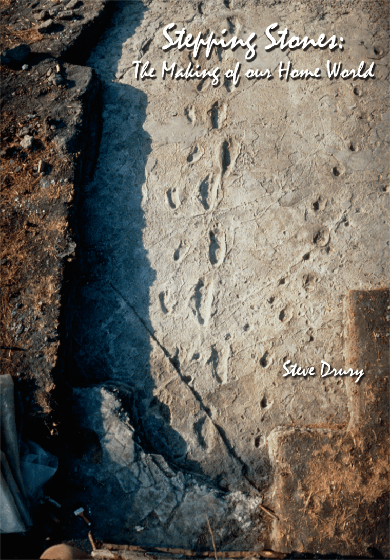
A fully revised edition of Steve Drury’s book Stepping Stones: The Making of Our Home World can now be downloaded as a free eBook
Iranians salvage their furniture and household appliances from damaged buildings in the town of Sarpol-e Zahab in Iran’s western Kermanshah province near the border with Iraq, on November 14, 2017
Under the auspices of the International Ocean Discovery Program (IODP), during April and May 2016 a large team of scientists and engineers sank a 1.3 km deep drill hole into the offshore, central part of the Chicxulub impact crater, which coincided with the K-Pg mass extinction event. Over the last year work has been underway to analyse the core samples aimed at investigating every aspect of the impact and its effects. Most of the data is yet to emerge, but the team has published the results of advanced modelling of the amount of climate-affecting gases and dusts that may have been ejected (Artemieva, N. et al. 2017. Quantifying the release of climate-active gases by large meteorite imp-acts with a case study of Chicxulub. Geophysical Research Letters, v. 44; DOI: 10.1002/2017GL074879). . From petroleum exploration in the Gulf of Mexico the impact site is known to have been underlain by about 2.5 to 3.5 km of Mesozoic sediments that include substantial amounts of limestones and evaporitic anhydrite (CaSO4) – thicknesses of each are of the order of a kilometre. The impact would inevitably have yielded huge volumes of carbon- and sulfur dioxide gases, as well as water vapour plus solid and molten ejecta. The first, of course, is a critical greenhouse gas, whereas SO2 would form sulfuric acid aerosols if it entered the stratosphere. They are known to block incoming solar radiation. So both warming and cooling influences would have been initiated by the impact. Dust-sized ejecta that lingered in the atmosphere would also have had climatic cooling effects. The questions that the study aimed to answer concerns the relative masses of each gas that would have reached more than 25 km above the Earth to have long-term, global climatic effects and whether the dominant effect on climate was warming or cooling. Both gases would have added the environmental effects of making seawater more acid.
3-D simulation of the Chicxulub crater based on gravity data (credit: Wikipedia)
Such estimates depend on a large number of factors beyond the potential mass of carbonate and sulfate source rocks. For instance: how big the asteroid was; how fast it was travelling and the angle at which it struck the Earth’s surface determine the kinetic energy involved and the impact mechanism. How that energy was distributed between atmosphere, seawater and the sedimentary sequence, together with the pressure-temperature conditions for the dissociation of calcite and anhydrite all need to be accounted for by modelling. Moreover, the computation itself becomes extremely long beyond estimates for the first second or so of the impact. Earlier estimates had been limited by computer speeds to only the first few seconds of the impact and could not allow for other than vertical impacts. The new study, by supercomputers and improved algorithms, used a likely 60° angle of impact, new data on mineral decomposition and simulated the first 15 to 30 seconds. The results suggested that 325 ± 130 Gt of sulfur and 425 ± 160 Gt CO2 were ejected, compared with earlier estimates of 40-560 Gt of sulfur and 350-3,500 Gt of CO2. The greater proportion of sulfur release to the stratosphere pushes the model decisively towards global cooling, probably over a lengthy period – perhaps centuries. Taking dusts into account implies that visible sunlight would also have been blocked, devastating the photosynthetic base of the global food chain, in the sunlit parts of oceans as well as on land.
But we have to remember that these are the results of a theoretical model. In the same manner as this study has thrown earlier modeling into doubt, more data – and there will be a great many from the Chicxulub drill core itself – and more sophisticated computations may change the story significantly. Also, the other candidate for the mass extinction event, the flood basalt volcanism of the Deccan Traps, and its geochemical effects on the climate have yet to be factored in. The next few lines of Shakespeare’s soliloquy for Richard III may well emerge from future work
… Made glorious summer by this sun of York;
And all the clouds that lour’d upon our house
In the deep bosom of the ocean buried …
Every evening’s TV schedules include either an ad for some kind of ‘virtual reality’ (VR) device or a ‘techie’ programme in which one appears. As well as massively multiplayer online role-playing games, commercial VR offers 3-D encounters with charging rhinoceroses, surfing, wingsuit flying and other ‘experiences’ that are either life threatening or viciously expensive. Second Life, the online virtual world (but not yet compatible with VR goggles), appeared as long ago as 2003 and at present has about a million regular users and many more have passed through its portal, eventually to tire of its cheesiness. Yet, Second Life no longer seems to be a topic of normal conversation; maybe aficionados don’t go out very often. The development software, the speed and resolution of computers, the peripheral technologies and the visual quality of immersive VR seem to be following something like Moore’s law – the observation that the number of transistors in a dense integrated circuit doubles approximately every two years. And VR gaming is clearly very profitable with revenues likely to rise from about US$17 million in 2014 to over US$ 20 billion by 2020.
Douglas McCauley writes in Science (Insights 20 October 2017) about the potential of digital games and simulation for expanding the reach of STEM education, particularly in his own field ecology (McCauley, D.J. 2017. Digital nature: Are field trips a thing of the past? Science, v. 359, p. 298-300; doi: 10.1126/science.aao1919). His view is partly positive, as they match the thirst for armchair experiences and the growing digital expertise of the billion or more gamers and many more whose culture is dominated by electronic media, skewed strongly to the under-24s. For instance, children in the US spend on average 7 hours per day online, but only 4 to 7 minutes of unstructured outdoor play. There are obvious opportunities to familiarise and enthuse young people with the staggering richness of the natural world, which none of us will ever be able to witness first hand. At a time when the UK National Trust reports, for instance, that only a third of British children can recognise a magpie (a distinctive and common European member of the crow family) whereas 9 out of 10 easily recognise a Dalek alien cyborg, there is clearly a need. Sixty years ago David Attenborough’s early monochrome Zoo Quest series on BBC TV definitely drew me into natural science as it did millions of others, and I for one am deeply grateful for his then somewhat awkward efforts. So it would be stupid to condemn the potential of VR and more plain-vanilla gaming methods as they could do much the same and probably a great deal more. But can it really teach the field skills needed by any potential observational scientist rather than just make people more interested?
McCauley is less certain on that front, and so am I. Studies have shown that virtual field trip participants perform no better than their peers who engaged only in conventional illustrated lectures. ‘Immersive’ experiences can simulate some, but not all aspects of real terrain, ecosystems and geological features. My own geological ventures have involved a ‘virtual’ aspect provided by remote sensing and image interpretation. Those now pretty aged technologies show ‘the big picture’ – with some zoom-in capacity – and provide insights into regional and, with Google Earth, local geological structures and relationships. By capturing imagery outside the humanly visible wavelength range they add a great deal about rock composition that would otherwise require large sample collections, petrographic interpretation of thin sections and some basic geochemistry. A stereoscopic 3-D view and the use of terrain in creating perspective oblique images also permit estimates of dip and strike of strata. But it is all a bit inhuman and alien, much the same as ‘doing’ geology on Mars without the opportunity to behave as a curious being would if actually on the surface. Any field scientist has real experience imprinted for years in much the same way as would her hunter-gatherer forbears, while it has been shown that virtual experiences may persist for a mere few weeks. My view is that often uncomfortable, total immersion in field reality, literally step-by-step and day after day fosters continual reflection during and for a long time after the experience. Much of science in general is about ‘mulling over’ observations at every level of detail; the more detail and the more repetition the deeper the insight and the more profound the breaks through.
As higher education continues along its path of commodification the more supposedly ‘immersive’ virtual experiences are likely to supplant field work, largely for cost reasons – both for students and institutions. In my former institution, to which I am still tenuously attached, a decision was taken 17 years ago to make residential field studies optional, and in 2011 to abandon them almost entirely in favour of ‘virtual’ experiences of one kind or another. The results have been dramatic: enrollment in geoscientific courses has fallen to a third of the pre-2000 level; retention has declined by up to 10% and pass rates have dropped significantly. The bottom line is that what we used to call Earth sciences has become increasingly marginalised as regards the range of courses on offer.
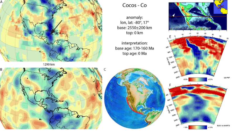
Where do old plates go to die? For the most part, down subduction zones to mix with their original source, the mantle. Earth-Pages has covered evidence for quite a few of the dead plates, which emerges from a geophysical technique known as seismic tomography – analogous to X-ray or magnetic resonance scans of the whole human body. For 20 years geophysicists have been analysing seismograms from many stations across the globe for every digitally recorded earthquake, i.e. virtually all of those since the 1970s. This form of depth sounding goes far beyond early deep-Earth seismometry that discovered the inner and outer core, various transition zones in the mantle and measured the average variation with depth of mantle properties. Tomography relies on complex models of the paths taken by seismic body waves and very powerful computing to assess variations in the speed of P- and S-waves as they travelled through the Earth: the more rigid/cool the mantle is the faster waves travel through it and vice versa. The result is images of deep structure in 2-D slices, but the quality of such sections depends, ironically, on plate tectonics. Most earthquakes occur at plate boundaries. Such linearly distributed, one-dimensional sources inevitably leave the bulk of the mantle as a blur. Around 20 different methodologies have been developed by the many teams working on seismic tomography. So sometimes conflicting images of the deep Earth have been produced.
Results of seismic tomography across Central America showing anomalously fast (in blue) P- (top) and S-wave (bottom) speeds in map view at a fixed mantle depth (1290 km, left) and as vertical sections (right). The blue zones at right are interpreted to show a steeply dipping slab that represents subduction of the eastern Pacific Cocos plate since about 175 Ma ago (credit: van der Meer, D.G et al. ‘Atlas of the Underworld)
The technique has come of age now that superfast computing and use of multiple models have begun to resolve some of tomography’s early problems. The latest outcome is astonishing: ‘The Atlas of the Underworld’ catalogues 94 2-D sections from surface to the core-mantle boundary each of which spans 40° or arc – about a ninth of the Earth’s circumference (see: van der Meer, D.G., van Hinsbergen, D.J.J., and Spakman, W., 2017, Atlas of the Underworld: slab remnants in the mantle, their sinking history, and a new outlook on lower mantle viscosity, Tectonophysics online; doi.org/10.1016/j.tecto.2017.10.004). Specifically, the Atlas locates remnants of relatively cold slabs in the mantle that are suspected to be remnants of former subduction zones, or those that connect to active subduction. The upper parts of active slabs are revealed by the earthquakes generate along them. At deeper levels they are too ductile to have seismicity, so what form they take has long been a mystery. Once subduction stops, so do the telltale earthquakes and the slabs ‘disappear’.
The slabs covered by the ‘Atlas’ only go back as far as the end of the Permian, when the current round of plate tectonics began as Pangaea started to break-up. It takes 250 Ma for slabs to reach the base of the mantle and beyond that time they will have heated up and begun to be mixed into the lower mantle and invisible. Nevertheless, the rich resource allows models of vanished Mesozoic to Recent plates and the tectonics in which they participated, based on geological information, to be evaluated and enriched. Just as important, the project opens up the possibility of finding out how the mantle ‘worked’ since Pangaea broke up, in 3-D; a key to more than plate tectonics, including the mantle’s chemical heterogeneity. Already it has been used to estimate changes in the total length of subduction zones since 250 Ma ago, and thus arc volcanism and CO2 emissions, which correlates with estimates of past atmospheric CO2 levels, climate and even sea levels.
Vindija cave near Varazdin in Croatia. (credit: Wikipedia)
Work on Neanderthal genomes continues, as expected. The latest news comes from remains of a Croatian female, whose genome has been determined by a team led by members of the Max Planck Institute for Evolutionary Anthropology in Leipzig (Prüfer, K. and 35 others 2017. A high-coverage Neandertal genome from Vindija Cave in Croatia. Science, online; doi:10.1126/science.aao1887). Her full genome is of higher quality than those previously published for Neanderthals. Dated at around 52 ka, her genetics is likely to be closer to those who mated with the ancestors of modern Eurasians. Kay Prüfer and his colleagues suggest that Neanderthals passed on to modern Eurasians genes associated with plasma levels of LDL cholesterol and vitamin D (mainly produced by skin exposure to sunlight, Vitamin D is essential for healthy bones and supports the immune system), together with risk factors for eating disorders, accumulation of visceral fat, rheumatoid arthritis and schizophrenia. Two other interesting possibilities stem from reconsidering genetic data from other Neanderthals, in the light of the new Croatian analysis. Ancestors of an older Neanderthal (122 ka) from the Altai region of Siberia had interbred with genetically modern humans as long ago as 130 ka. Yet the genomes of the Altai and Croatian Neanderthals are surprisingly similar, suggesting that both lived in isolated small groups around three thousand strong (Gibbons, A. 2017. Neanderthal genome reveals greater legacy in the living. Science, v. 358 p. 21).
Also published on-line by Science is a study of the genomes of 7 individual anatomically modern humans from KwaZulu-Natal in South Africa (Schlebusch, C.M. and 11 others 2017. Southern African ancient genomes estimate modern human divergence to 350,000 to 260,000 years ago. Science online; doi: 10.1126/science.aao6266). They are three 2000 year-old hunter-gatherers (probably San) and four Iron Age farmers, similar to modern Bantu speakers, from 300 to 500 years ago. Although genomes from modern Khoe-San suggest up to 30% admixture from East Africans and Eurasians, comparison between the two ancient groups suggest a very old divergence among African anatomically modern human (AMH) populations, of the order of 350 to 260 ka ago. This is long before the remains from Ethiopia, widely accepted as the oldest known AMH (190 ka), but roughly the same as recently described fossils from Jebel Irhoud in Morocco (325 to 286 ka) reckoned to be early AMH. The Moroccan humans and now the genetic analysis from much more recent South African skeletons point to a pan-African early evolution of modern people rather than some kind of ‘cradle of humanity’.
Adult male in an Upper Paleolithic (28-30 ka) burial at Sunghir, Russia. (credit: Wikipedia)
More ancient AMH hunter-gatherers (~28 to 30 ka) occur at Sunghir, about 200 km east of Moscow, a settlement that includes several burials – one of which contained a boy and a girl – many with abundant, ornate grave goods. It seems likely that all the interred individuals were related and so an excellent target for DNA analysis. Four individuals with roughly the same 14C age did yield enough for genome sequencing (Sikora, M. and 26 others 2017. Science, online; doi: 10.1126/science.aao1807). It turned out from their mtDNA that none were more closely related than first-cousins or great-grandchildren. The data suggested a relatively small breeding population (~300) that avoided inbreeding and its often negative consequences, possibly through exogamy (a wide mating network) as practiced by living hunter-gatherers. Remarkably, the data also hinted at relationship with earlier (36 ka) individuals from Kostenki about 300 km to the south-west. DNA from several Siberian Neanderthal individuals do suggest that inbreeding had been an issue. Had it been widespread among Neanderthals – risky to infer from such scanty information – that may account for their lack of competitiveness with AMH and eventual demise.
Enhanced gravity map of the Chicxulub crater (credit: Wikipedia)
Michael Rampino has produced a new book (Rampino, M.R. 2017. Cataclysms: A New Geology for the Twenty-First Century. Columbia University Press; New York). As the title subtly hints, Rampino is interested in mass extinctions and impacts; indeed quite a lot more, as he lays out a hypothesis that major terrestrial upheavals may stem from gravitational changes during the Solar System’s progress around the Milky Way galaxy. Astronomers reckon that this 250 Ma orbit involves wobbling through the galactic plane and possibly varying distributions of mass – stars, gas, dust and maybe dark matter – in a 33 Ma cycle. Changing gravitational forces affecting the Solar System may possibly fling small objects such as comets and asteroids towards the Earth on a regular basis. In the 1980s and 90s Rampino and others linked mass extinctions, flood-basalt outpourings and cratering events, with a 27 Ma periodicity. So the books isn’t entirely new, though it reads pretty well.
Such ideas have been around for decades, but it all kicked off in 1980 when Luis and Walter Alvarez and co-workers published their findings of iridium anomalies at the K-Pg boundary and suggested that this could only have arisen from a major asteroid impact. Since it coincided with the mass extinction of dinosaurs and much else besides at the end of the Cretaceous it could hardly be ignored. Indeed their chance discovery launched quite a bandwagon. The iridium-rich layer also included glass spherules, shocked mineral grains, soot and other carbon molecules –nano-scale diamonds, nanotubes and fullerenes whose structure is akin to a geodesic dome – and other geochemical anomalies. Because the Chicxulub crater off the Yucatán Peninsula of Mexico is exactly the right age and big enough to warrant a role in the K-Pg extinction, these lines of evidence have been widely adopted as the forensic smoking gun for other impacts. In the last 37 years every extinction event horizon has been scrutinized to seek such an extraterrestrial connection, with some success, except for exactly coincident big craters.
The K-Pg event is the only one that shows a clear temporal connection with a small mountain falling out of the sky, most of the others seeming to link with flood basalt events and their roughly cyclical frequency – but hence Rampino’s Shiva hypothesis that impacts may have caused the launch of mantle plumes from the core-mantle boundary. Others have used the ‘smoking gun’ components to link lesser events to a cosmic cause, the most notorious being the 2007 connection to the extinction of the North American Pleistocene megafauna and the start of the Younger Dryas return of glacial conditions. Since 1980 alternative mechanisms for producing most of the impact-connected materials have been demonstrated. It emerged in 2011 that nano-diamonds and fullerenes may form in a candle flame and their global distribution could be due to forest fires. And now it seems that shocked mineral grains can form during a lightning strike (Chen, J. et al. 2017. Generation of shock lamellae and melting in rocks by lightning-induced shock waves and electrical heating. Geophysical Research Letters, v. 44, p. 8757-8768; doi:10.1002/2017GL073843). Shocked or not, quartz and feldspar grains are resistant enough to be redistributed into sediments. Although platinum-group metals, such as iridium, are likely to be mainly locked away in Earth’s core, some volcanic exhalations and many flood basalts – especially those with high titanium contents – significantly are enriched in them. So even the Alvarez’s evidence for a K-Pg impact has an alternative explanation. Rampino is to be credited for acknowledging that in his book.
An awful lot of ideas about rare yet dreadful events in the biosphere depend, like many criminal cases, on the ‘weight of evidence’ and defy absolute proof. The evidence generally permits alternatives, such the cunning Verneshot hypothesis for the extinction-flood basalt connection supported by one of the founders of plate tectonics, W. Jason Morgan. As regards The K-Pg extinction, it is certain that a very large mass did fall on Chicxulub at the time of the mass extinction, whereas the Deccan flood basalts span a million years or so either side. But the jury is out on whether either or both did the deed. For other events of this scale and larger ones the money is on internal origins. As for Rampino’s galactic hypothesis, the statistics are decidedly dodgy, but chasing down more forensics is definitely on the cards.
Animation showing the Chicxulub Crater impact. ( credit: University of Arizona, Space Imagery Center)
Most volcanic activity stems from the rise of hot, deep rock, usually within the mantle. Pressure suppresses partial melting, so as hot rock rises the greater the chance that it will begin to melt without any rise in its temperature. That is the reason why mantle plumes are associated with many volcanic centres within plates. Extension at oceanic ridges allows upper mantle to rise in linear belts below rift systems giving rise to shallow partial melting, mid-ocean ridge basalts and sea-floor spreading. These aren’t the only processes that can reduce pressure to induce such decompression melting; any means of uplift will do, provided the rate of uplift exceeds the rate of cooling at depth. As well as tectonic uplift and erosion, melting of thick ice sheets and major falls in sea level may result in unloading of the lithosphere.
During Messinian Stage of the late Miocene up to 3 km of evaporitic salt was deposited in the deepest parts of the Mediterranean Basin. One mechanism might have been faster evaporation of seawater than its resupply from the Atlantic through the Straits of Gibraltar, similar to the way in which salts is deposited below the Dead Sea. But the salt layer beneath the modern Mediterranean Sea bed has interleaved riverine sediments containing fossils of land plants. The Straits had closed and the Mediterranean Sea evaporated away. From about 6 to 5.3 Ma ago sea level fell by 3 to 5 km, only returning to normal when the Straits reopened to launch the huge Zanclean flood, with which the Pliocene of southern Europe and North Africa commenced. A team from the Universities of Geneva, Orleans and Paris and the Instituto de Ciencias de la Tierra Jaume Almera in Barcelona has tested the hypothesis that the Messinian Crisis affected volcanic activity in the area (Sternai, P. et al. 2017. Magmatic pulse driven by sea-level changes associated with the Messinian salinity crisis. Nature Geoscience, v. 10 online; doi:10.1038/ngeo3032).
From the record of salt precipitation, Pietro Sternai and colleagues, reckon that the main phase of unloading of the Mediterranean Basin began at around 5.6 Ma. Allowing for loading by the thick evaporites they calculated that the effect of the loss of water mass was equivalent to an unloading of 15 MPa in the deeper Eastern Mediterranean and 10 MPa in the west. Using standard pressure-temperature melting curves for the upper mantle, they then estimated that any magma chambers affected by the decrease in pressure could yield up to 17% more melt. Radiometrically dated lavas and igneous dykes within the Mediterranean region became more frequent and the number of events more than doubled during the time of main salt deposition.
Stromboli, one of the most active volcanoes in the Mediterranean Basin (credit: Wikipedia)
In May 2017 a study of subglacial volcanoes in West Antarctica based on radar mapping of the solid surface identified 138, 91 of them previously unknown (van Wyk de Vries et al. 2017. A new volcanic province: an inventory of subglacial volcanoes in West Antarctica. Geological Society, London, Special Publication 461) They lie within a buried rift system and are covered by thick ice. Only one volcano in Antarctica is known to be active, Erebus, which is part of the cluster. Most of the news items stemming from the publication mentioned the possibility that the buried volcanic tract could be adding to the instability of the West Antarctic Ice Sheet through heating up its base. The WAIS is the ice sheet most feared to collapse seawards leading to a rise of about 3 m in global sea level. If the 2 km thick WAIS did slide off its underlying crust it might possibly trigger reactivation of the volcanic cluster.
Despite the lingering public image that Neanderthals were not as bright as fully modern humans some had significantly larger brains than we do, albeit with most of the difference being in the rear part of the brain region. So they may have had different powers, such as enhanced vision and awareness of position (proprioception). Because there are few cranial fossils of immature Neanderthals and, for them, little evidence of ages, not much is known about how they developed from birth. A common assumption has been that because their brain was larger post-natal development much have been faster than in modern humans. Set against our slow post-natal development and the faster pace in chimpanzees this assumption has been used in support of limited Neanderthal cognitive abilities.
The El Sidron Neanderthal boy, including a reconstruction of his skull and brain cast. (credit: Antonio Rosas, Museo Nacional de Ciencias Naturales, Madrid, Spain)
The El Sidron cave in Asturias region of northern Spain has yielded fossil remains of a dozen Neanderthals dated at between 49 and 37 ka, the time when anatomically modern humans were also present in Europe. They are among the best studied examples of this human group. Three were of boys, the best preserved of whom is estimated to have died at 7.7 years old from analysis of his dental development (Rosas, A. and 10 others 2017. The growth pattern of Neandertals, reconstructed from a juvenile skeleton from El Sidrón (Spain). Science, v. 357, p. 1282-1287; doi:10.1126/science.aan6463) Analysis of signs of the maturation stage that he had reached, including that of his brain, show no fundamental difference from modern human juveniles in his overall pace of growth. Other workers have found that a similarly aged Homo erectus boy from Kenya had indeed developed more quickly than modern human juveniles.
It’s not much to go on, but the El Sidron boy supports the view that Neanderthals were not much different from us.
You can find more information on migration of modern humans here.
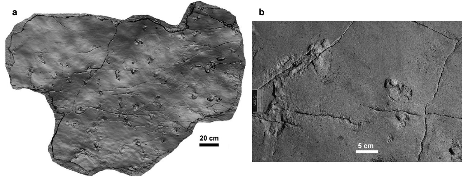
To see traces of where our forebears walked, such as the famous Australopithecusafarensistrackway at Laetoli in Tanzania, the footprints of Neanderthal children in 350 ka old Italian volcanic ash (The first volcanologists? Earth Pages March 2003) or even those of Mesolithic families in estuarine mud is about as heart stopping as it gets for a geologist. But imagine the astonishment of members of a multinational team working on Miocene shore-line sediments on Crete when they came upon a bedding surface covered with what are almost certainly the footprints of another bipedal animal from 5.7 Ma ago (Gierliński, G.D. et al. 2017. Possible hominin footprints from the late Miocene (c. 5.7 Ma) of Crete? Proceedings of the Geologists’ Association, online; https://doi.org/10.1016/j.pgeola.2017.07.006). Trackways preserve a few moments in time, however old they are and the chances of their being preserved are very small, yet they can supply information that is lost from even the best preserved fossil, such as gait, weight, speed and so forth.
Track bearing surface; (b) two footprints in 5.7 Ma old Miocene sediments at Trachilos, Crete (credit: Gierliński, G.D. et al. 2017; Figures 2 and 8)
The tracks clearly indicate that whatever left them was bipedal and lacked claws, and closely resemble those attributed to A. afarensis at Laetoli in a 3.7 Ma old volcanic ash. What they do not resemble closely are those of non-hominin modern primates, such as chimpanzees. They are diminutive compared with adult modern human prints, being about 12.5 cm long (equivalent to a UK child’ shoe size 4 – US size 4.5, EU 20) and about a third to half the size of those at Laetoli. Were they around the age of those at Laetoli or younger there seems little doubt that they would be widely interpreted as being of hominin origin. But being from an island in the Mediterranean as well as far from sites in Africa that have yielded Miocene hominins (Ardipithecus kadabba from Ethiopia, Orrorin from Kenya and Sahelanthropusfrom Chad), such an interpretation is bound to create controversy. Somewhat less controversial might be to regard them as having been created by a late-Miocene primate that convergently evolved a hominin-like upright gait and foot. Being preserved in what seem to be coastal marine sediments, there is probably little chance of body fossils being preserved in the exposed horizon. Since foot bones are so fragile, even if a primate fossil is discovered in the late Miocene of Crete the chances of resolving the issue are pretty remote. Yet fossil primate specialists will undoubtedly beat a well-trodden path to the Trachilos site near Kissamos on Crete
It is now certain that the Cretaceous-Palaeogene boundary 66 Ma ago coincided with the impact of a ~10 km diameter asteroid that produced the infamous Chicxulub crater north of Mexico’s Yucatán peninsula. Whether or not this was the trigger for the mass extinction of marine and terrestrial fauna and flora – the flood basalts of the Deccan Traps are still very much in the frame – the worldwide ejecta layer from Chicxulub coincides exactly with the boundary that separates the Mesozoic and Cenozoic Eras. As well as shocked quartz grains, anomalously high iridium concentrations and glass spherules the boundary layer contains abundant elemental carbon, which has been widely ascribed to soot released by vegetation that went up in flames on a massive scale. Atmospheric oxygen levels in the late Cretaceous were a little lower than those at present, or so recent estimates from carbon isotopes in Mesozoic to Recent ambers suggest (Tappert, R. et al. 2013. Stable carbon isotopes of C3 plant resins and ambers record changes in atmospheric oxygen since the Triassic. Geochimica et Cosmochimica Acta, v.121, p. 240-262,) – other estimates put the level substantially above that in modern air. Whatever, global wildfires occurred within the time taken for the Chicxulub ejecta to settle from the atmosphere; probably a few years. It has been estimated that about 700 billion tonnes of soot were laid down, suggesting that most of the Cretaceous terrestrial biomass and even a high proportion of that in soils literally went up in smoke.
Charles Bardeen and colleagues at the University of Colorado, Boulder, have modelled the climatic and chemical effects of this aspect of the catastrophe (Bardeen, C.G. et al. 2017. On transient climate change at the Cretaceous−Paleogene boundary due to atmospheric soot injections. Proceedings of the National Academy of Sciences; doi:10.1073/pnas.1708980114). Despite the associated release of massive amounts of CO2 and water vapour by both the burning and the impact into seawater, giving increased impetus to the greenhouse effect, the study suggests that fine-grained soot would have lingered as an all enveloping pall in the stratosphere. Sunlight would have been blocked for over a year so that no photosynthesis would have been possible on land or in the upper ocean, the temperatures of the continent and ocean surfaces would have dropped by as much as 28 and 11 °C respectively to cause freezing temperatures at mid-latitudes. Moreover, absorption of solar radiation by the stratospheric soot layer would have increased the temperature of the upper atmosphere by several hundred degrees to destroy the ozone layer. Consequently, once the soot cleared the surface would have had a high ultraviolet irradiation for around a year.
The main implication of the modelling is a collapse in both green terrestrial vegetation and oceanic phytoplankton; most of the food chain would have been absent for long enough to wipe out those animals that depended on it entirely. While an enhanced greenhouse effect and increased acidification of the upper ocean through CO2 emissions by the Deccan flood volcanism would have placed gradually increasing and perhaps episodic stresses on the biosphere, the outcome of the Chicxulub impact would have been immediate and terrible.
More on mass extinctions and impacts here and here
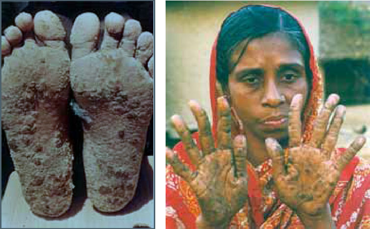
In the 1980s grim news began to emerge from the Indian State of West Bengal and a decade later from neighbouring Bangladesh. Villagers from the low-lying delta plains of the Ganges and Brahmaputra river systems at the head of the Bay of Bengal began to present at clinics with disfiguring skin lesions or keratoses on hands and feet, loss of feeling in fingers and toes and dark skin patches on their torsos. The latter were colloquially known as ‘black rain’. The victims were often stigmatised, as their neighbours believed they were suffering from leprosy. These symptoms were followed a few years later by increased incidences of lung, liver, kidney and bladder cancers. The first medical practitioner to recognise these typical signs of chronic arsenic poisoning in 1983, Dr Depankar Chakraborti of Kolkata, was branded as a ‘panic monger’ by local authorities. His warnings, backed by evidence published by the World Health Organisation (WHO) in 1988 that there was a connection with high arsenic levels in West Bengal drinking water supplies from new tubewells, went largely unheeded for a decade. Tragically, as it turned out, thousands of tubewells had been sunk in the Bengali delta plains from the 1970s onwards, aimed at reducing the risk of disease from pathogens in the previously used surface water from ponds and streams. After a conference on the perceived problem, organized in Kolkata by Dr Chakraborti in 1995, the WHO declared the situation in Bangladesh to be a ‘Major Public Health Issue’, and the world’s press took up the story. Clearly, millions of Bengali villagers were at risk or were already suffering from chronic arsenic poisoning. By the late 1990s thousands of samples of tubewell waters from the delta plains had been analysed, many of which revealed arsenic levels far above the 10 μg l-1 safe threshold. In 2002, 400 Bangladeshi victims sued the British Geological Survey (BGS) for negligence. The BGS had analysed 150 water samples from the Bangladesh delta plains in 1992 and had not reported any risks, but arsenic was not among the elements being analysed. The civil action eventually failed.
Skin lesions or keratoses that are symptomatic of chronic arsenic poisoning
Almost two decades after the arsenic scandal on the eastern side of the subcontinent well-water analyses showing high arsenic values have been published from the Indus plains of Pakistan (Podorski, J.E. et al. 2017. Extensive arsenic contamination in high-pH unconfined aquifers in the Indus Valley. Science Advances, v. 3,; doi:10.1126/wsciadv.1700935). The Indus catchment having a similar Himalayan source and being at a similar latitude it has long been considered to be at potential risk from arsenic derived from its thick alluvial sediments. The Swiss-Pakistani-Chinese team have produced geochemical data from 1200 tubewells throughout the catchment within Pakistan. A swath from Lahore to Karachi, with the country’s greatest population density, is at high risk of water with arsenic concentrations above the WHO guideline safe concentration, suggesting some 50 to 60 million people being subject to its hazard.
Although the geological setting is similar to that in the Bengal plains, a different natural chemical process causes the high concentrations ultimately from the iron hydroxide veneer on sediment grains which selectively absorbs several trace elements, including arsenic, from river water. In Bangladesh arsenic is released from sediments as a result of highly reducing conditions due to organic matter buried in some layers of alluvium, by a process known as reductive dissolution – when insoluble ferric iron (Fe3+) hydroxide (goethite) is exposed to a ready supply of electrons the iron is reduced to the soluble ferrous (Fe2+) form and the mineral breaks down to release its absorbed trace elements. Most of the alluvium in the Indus plain contains little organic carbon, so another mechanism is implicated. The high arsenic levels correlate with high pH in the groundwater and therefore seem most likely to be released from goethite grain coatings by alkaline water. That, in turn, is often a product of high evaporation and salinisation from the massive irrigation using groundwater in semi-arid southern Pakistan. The alkaline water then returns to the underlying groundwater in the highly permeable Indus alluvium; i.e. it is a consequence of irrigated agriculture rather than of a natural geochemical process as in more humid Bengal.
Whereas a remedy in Bangladesh and West Bengal has been to sink new tubewells into oxidising alluvial strata (red coloured rather than the reducing grey sediments) that yield water with safe arsenic levels, the risky areas in Pakistan may need expensive use of absorbent filters on a large scale to remove the hazard. Because irrigation using groundwater is on such a large scale on the Indus plain there is also a definite risk of ingesting arsenic from crops produced there, principally rice but also unwashed leaf vegetables
In late July 2017 news emerged that modern humans first reached Australia at least 65 thousand years ago. Confirming that the date of departure from Africa to end up in SE Asia and Australasia was considerable earlier than previously believed, deposits in Sumatra that contain remains of early Home sapiens have yielded even older ages (Westaway, K.E. and 22 others 2017. An early modern human presence in Sumatra 73,000–63,000 years ago. Nature v. 548 online; doi:10.1038/nature23452). This resulted from a re-examination of material from the Padang Caves first excavated more than a century ago by Eugène Dubois, famous for his discovery in Java of the first H. erectus remains. A richly fossiliferous breccia in the Lida Ajer cave yielded a fauna characteristic of a rainforest biome and included two teeth that Dubois considered to be human. Several later palaeontologists confirmed his identification as have hominin specialists in the present Australian-Indonesian-American-British-Dutch-German team. The fossil assemblage has long suggested great antiquity for the site, but only now has it been dated precisely. The dating employed three methods: optically stimulated luminescence dating of quartz grains from the breccia (85±25 to 62±5 ka); uranium-series dating of speleothem including fragments of hollow ‘soda-straw’ stalactites(84±1 to 71±7 ka); uranium-series dating of gibbon and orangutan teeth found together with the human teeth (86±13 to 76±7 ka). Statistical analysis of the age data suggests 73 to 63 ka for the fauna, with a maximum age for deposition of the breccia of 84±1 ka.
Satellite image of Lake Toba in NW Sumatra (at centre), the site of the largest volcanic eruption during the history of human evolution ~71,600 years ago (credit: Wikipedia)
Stone tools which may have been carried by anatomically modern humans into the area have previously been used to suggest a minimum date of the arrival of migrants, though they may have been carried by H. erectus. Remarkably, such tools have been found beneath a thick bed of volcanic ash found throughout southern Asia and in Indian Ocean sediment cores. This has been dated at 71.6 ka and represents the explosive collapse of the caldera now containing Lake Toba in NW Sumatra that was the largest volcanic event in the entire history of the genus Homo. The new age data from Lida Ajer suggests that modern humans were present in its vicinty before the eruption, a view also supported by ‘molecular-clock’ dating of the range of mitochondrial DNA carried by living SE Asian people (79 to 75 ka). So, despite the stupendous magnitude of the Toba eruption is seems likely that some of the migrants survived. Together with the dating of the earliest Australians the Sumatran evidence is at odds with the view, widely held by palaeoanthropologists, that the ‘Out of Africa’ exodus began by crossing the Straits of Bab el Mandab between 74 and 58 ka when global sea-level fell markedly during marine oxygen-isotope Stage 4 (MIS4). A problem with that hypothesis has been that climatic and ecological conditions in southern Asia during MIS4 were unfavourable. But is seems that modern humans were already there and capable of adapting to both the climate shift and to the devastation undoubtedly caused by Toba.
The dominant feature of Phanerozoic stratigraphy is surely the way that many of the formally named major time boundaries in the Stratigraphic Column coincide with sudden shifts in the abundance and diversity of fossil organisms. That is hardly surprising since all the globally recognised boundaries between Eras, Periods and lesser divisions in relative time were, and remain, based on palaeontology. Two boundaries between Eras – the Palaeozoic-Mesozoic (Permian-Triassic) at 252 Ma and Mesozoic-Cenozoic (Cretaceous-Palaeogene) at 66 Ma – and a boundary between Periods – Triassic-Jurassic at 201 Ma – coincide with enormous declines in biological diversity. They are defined by mass extinctions involving the loss of up to 95 % of all species living immediately before the events. Two other extinction events that match up to such awesome statistics do not define commensurately important stratigraphic boundaries. The Frasnian Stage of the late-Devonian closed at 372 Ma with a prolonged series of extinctions (~20 Ma) that eliminated at least 70% of all species that were alive before it happened. The last 10 Ma of the Ordovician period witnessed two extinction events that snuffed out about the same number of species. The Cambrian Period is marked by 3 separate events that in percentage terms look even more extreme than those at the end of the Ordovician, but there are a great many less genera known from Cambrian times than formed fossils during the Ordovician.
Faunal extinctions during the Phanerozoic in relation to the Stratigraphic Column.
Empirical coincidences between the precise timing of several mass extinctions with that of large igneous events – mainly flood basalts – suggest a repeated volcanic connection with deterioration of conditions for life. That is the case for four of the Famous Five, the end-Ordovician die-off having been ascribed to other causes; global cooling that resulted in south-polar glaciation of the Gondwana supercontinent and/or an extra-solar gamma-ray burst (predicated on the preferential extinction of Ordovician near-surface, planktonic fauna such as some trilobite families). Neither explanation is entirely satisfactory, but new evidence has emerged that may support a volcanic trigger (Jones, D.S. et al. 2017. A volcanic trigger for the Late Ordovician mass extinction? Mercury data from south China and Laurentia. Geology, v. 45, p. 631-634; doi:10.1130/G38940.1). David Jones and his US-Japan colleagues base their hypothesis on several very strong mercury concentrations in thin sequences in the western US and southern China of late Ordovician marine sediments that precede, but do not exactly coincide with, extinction pulses. They ascribe these to large igneous events that had global effects, on the basis of similar Hg anomalies associated with extinction-related LIPs. Yet no such volcanic provinces have been recorded from that time-range of the Ordovician, although rift-related volcanism of roughly that age has been reported from Korea. That does not rule out the possibility as LIPs, such as the Ontong Java Plateau, are known from parts of the modern ocean floor that formed in the Mesozoic and Cenozoic. Ordovician ocean floor was subducted long ago.
The earlier Hg pulses coincide with evidence for late Ordovician glaciations over what is now Africa and eastern South America. The authors suggest that massive volcanism may then have increased the Earth’s albedo by blasting sulfates into the stratosphere. A similar effect may have resulted from chemical weathering of widely exposed flood basalts which draws down atmospheric CO2. The later pulses coincide with the end of Gondwanan glaciation, which may signify massive emanation of volcanic CO2 into the atmosphere and global warming. Despite being somewhat speculative, in the absence of evidence, a common link between the Big Five plus several other major extinctions and LIP volcanism would quieten their popular association with major asteroid and/or comet impacts currently being reinvigorated by drilling results from the K-Pg Chicxulub crater offshore of Mexico’s Yucatan Peninsula.
When modern humans first reached Australia has an importance beyond the starting date for the island continent’s archaeology and confirmation that their ancestors are the oldest known migrants from Africa. The first native Australians carried within their genome important information about the minimum date at which some non-Africans interbred with more archaic Neanderthal and Denisovan humans, traces of whose DNA are are present in that of living Australian aborigines. Most dating of when modern humans first reached different parts of the non-African world has relied on the radiocarbon method, which is suspect from beyond 40 to 45 ka as 14C produced earlier has decayed to levels that are now below the practical limit of detection and measurement. It is therefore no accident that the bulk of ‘first-arrival’ dates for Eurasia and Australasia are around 45 ka. In fact, any accurate age, however old, for the earliest skeletal remains only indicates the minimum date of arrival until other remains are discovered.
Reliable dating of earlier events in the Pleistocene relies on other methods, the most important for settings other than speleothem from caves being optically stimulated luminescence (OSL) applied to soil minerals that estimates their time of burial. Briefly, molecules of soil grains made of a mineral such as quartz are ‘charged-up’ with energy by radiation emitted by unstable isotopes in the soil. Exposure to light releases that stored energy in the form of luminescence. Measuring the amount of luminescence emitted by optically stimulated grains therefore gives a measure of the time since they were buried and ceased to be exposed to sunlight.
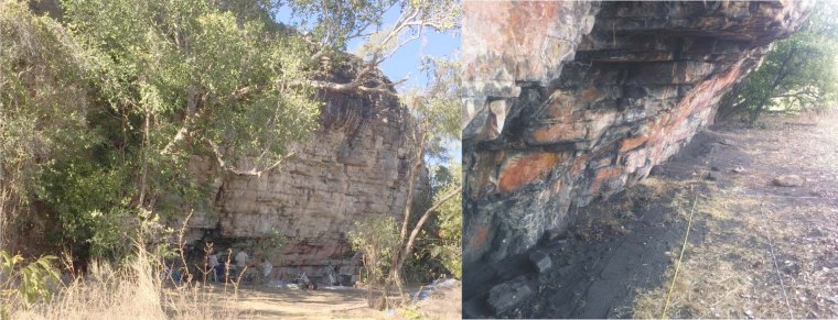
The Madjedbebe rock shelter in Arnhem Land, Northern Territories, Australia. (Credit: Chris Clarkson, University of Queensland)
A re-evaluation of the Madjedbebe site in the Northern Territory, widely accepted as having yielded Australia’s oldest artefacts in 1989, takes back human occupation more than 20 thousand years before previous estimates (Clarkson and 27 others 2017. Human occupation of northern Australia by 65, 000 years ago. Nature, v. 547, p. 306-310; doi:10.1038/nature22968). The soil profile in the Madjedbebe rock shelter turns out to be littered with artefacts – including hearths, tools and blocks of ochre and reflective mica pigments, plus remnants of plant foods – to a depth of ~2.5 m, with three particularly dense accumulations. Carbon-rich remains are also present throughout the profile which provided a means of accurate calibration and confirmation of OSL dates back as far as the radiocarbon method allows, giving confidence in the older OSL dates that extend to 65.0±5.7 ka in the earliest zone of dense artefact finds. Because the modern DNA of Australia’s first native people shows no sign of mixture with other modern humans, this places the timing of modern human interbreeding with archaic people before this time. The age also predates the range when the continent’s megafauna began to decline to eventual extinction, which supports the view that it was anthropogenic.
See also: Marean, C.W. 2017. Early signs of human presence in Australia. Nature, v. 547, p. 285-287; doi:10.1038/547285a.
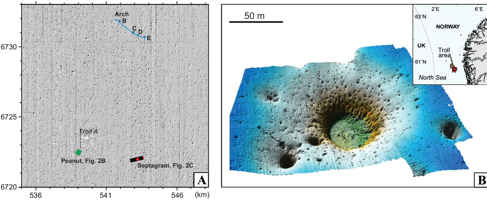
Detailed acoustic imaging above the Troll gas field in the northern North Sea off western Norway has revealed tens of thousands of elliptical pits on the seabed. At around 10 to 20 per square kilometre over an area of about 15,000 km2 there are probably between 150 to 300 thousand of them. They range between 10 to 100 m across and are about 6 m deep on average, although some are as deep as 20 m. They are pretty much randomly distributed but show alignment roughly parallel to regional N-S sea-floor currents. Many of the world’s continental shelves display such pockmark fields, but the Troll example is among the most extensive. Almost certainly the pockmarks formed by seepage of gas or water to the surface. However, detailed observations suggest they are inactive structures with no sign of bubbles or fluid seepage. Yet the pits cut though glacial diamictites deposited by the most recent Norwegian Channel Ice Stream through which icebergs once ploughed and which is overlain by thin Holocene marine sediments. One possibility is that they record gas loss from the Troll field, another being destabilisation of shallow gas hydrate deposits.
Parts of the Troll pockmark field off Norway. A: density of pockmarks in an area of 169 square km. B: details of a cluster of pockmarks. (Credit: Adriano Mazzini, Centre for Earth Evolution and Dynamics (CEED) University of Oslo)
Norwegian geoscientists have studied part of the field in considerable detail, analysing carbonate-rich blocks and foraminifera in the pits (Mazzini, A. and 8 others 2017. A climatic trigger for the giant Troll pockmark field in the northern North Sea. Earth and Planetary Science Letters, v. 464, p. 24-34; http://dx.doi.org/10.1016/j.epsl.2017.02.014). The carbonates show very negative δ13C values that suggest the carbon in them came from methane, which could indicate either of the two possible means of formation. However, U-Th dating of the carbonates and radiocarbon ages of forams in the marine sediment infill suggest that they formed at around 10 ka ago; 1500 years after the end of the Younger Dryas cold episode and the beginning of the Holocene interglacial. Most likely they represent destabilisation of a once-extensive, shallow layer of methane hydrates in the underlying sediments, conditions during the Younger Dryas having been well within the stability field of gas hydrates. Sporadic leaks from the deeper Troll gas field hosted by Jurassic sandstones is unlikely to have created such a uniform distribution of gas-release pockmarks. Adriano Mazzini and colleagues conclude that rapid early Holocene warming led to sea-floor temperatures and pressures outside the stability field of gas hydrates. There are few signs that hydrates linger in the area, explaining the present inactivity of the pockmarks – all the methane and CO2 escaped before 10 ka.
Gas hydrates are thought to be present beneath shallow seas today, wherever sea-floor sediments have a significant organic carbon content and within the pressure-temperature window of stability of these strange ice-like materials. Mazzini et al.’s analysis of the Troll pockmark field clearly has profound implications for the possible behaviour of gas hydrates at a time of global climatic warming. As well as their destabilisation adding to methane release from onshore peat deposits currently locked by permafrost and a surge in global warming, there is an even more catastrophic possibility. The whole of the seaboard of the southern North Sea was swept by a huge tsunami about 8000 years ago, which possibly wiped out Mesolithic human occupancy of lowland Britain, the former land mass of Doggerland, and the ‘Low Countries’ of western Europe. This was created by a massive submarine landslide – the Storegga Slide just to the north of the Troll field – which may have been triggered by destabilisation of submarine gas hydrates during early Holocene warming of the oceans.
The Earth’s mantle probably contained a significant amount of water from the start. Its earliest history was one of intense bombardment, including the impact that formed the Moon. Together with the conversion of gravitational potential energy to heat while the core was settling out from the mantle, impacts would have kept its overall temperature high enough to prevent water vapour from condensing on the surface until such heat input ceased and heat loss by radiation allowed the surface rapidly to cool. The atmosphere would have been rich in water vapour. Evidence from zircons that are the earliest tangible materials yet recovered hint at the formation of Zr-rich magmas – probably granitic in the broad sense – about 100 Ma after the Moon-forming event (see EPN July 2001: Zircons’ window on the Hadean). Yet no trace of substantial granitic rocks that old have ever been found.
Don Baker and Kassandra Sofonio of McGill University in Montreal, Canada have considered processes other than partial melting or fractional crystallisation that may have been possible during the earliest Hadean. In particular they have looked at one thought once to be a contender in the genesis of granite and latterly sidelined (Baker, D.R. & Sofonio, K. 2017. A metasomatic mechanism for the formation of Earth’s earliest evolved crust. Earth and Planetary Science Letters, v. 463, p. 48-55; http://dx.doi.org/10.1016/j.epsl.2017.01.022 ). They heated powdered artificial samples that chemically resembled the Earth’s original silicate mantle in sealed double capsules – an inner part containing the silicate powder and an outer one containing water. The capsules were held at around 727°C for a time and then quenched. The outer part of each capsule was found to be a glass of roughly granite composition. The experimental design ensured that superheated water diffused across the inner-outer capsule wall. So the ‘granite’ must have formed by a metasomatic process – essentially preferential solution of its component elements in supercritical water – the experimental temperature being insufficient to partially melt the ultramafic charge in the inner capsule.
Baker and Sofonio conclude that degassing of this metasomatic fluid – silicate-rich ‘steam’ – may have produced substantial masses of sialic crust on the Earth’s surface. Removal of material produced in such a manner would also have extracted trace elements with an affinity for granite from the early mantle – so-called incompatible elements. The subsequent recycling of such granitic blobs back into the mantle may explain geochemical signs in >500 Ma younger Archaean crust – produced by ‘normal’ igneous processes – of incompatible-element enriched reservoirs in the Early mantle.
How evolution proceeds and species arise are affected by many different processes. But, if members of every generation of the clade that led from the probable common ancestor of ourselves, Neanderthals, Denisovans and other hominins of the last 700 ka or so – widely thought to have been Homo heidelbergensis – were found as perfectly preserved fossils they would show gradually shifting anatomical features that from time to time and place to place would diverge to lead to different species. If, also, every specimen was accurately dated then there would be the last part of the human evolutionary bush laid out in a 3-D graphic. That is never going to be possible, of course. Human fossils are rare and there are few of them that are well-preserved. So the field of human origins throws up surprises on a regular basis, and if palaeoanthropologists were more dogmatic than most of them actually are there would be equally regular, public displays of the eating of hats.
As regards early modern H. sapiens, fossils from a couple of sites in Ethiopia have been the oldest known, at between 160 to 195 ka, for the last 15 years. However, in the 1960s quarry workers at Jebel Irhoud in SW Morocco exposed the infill of a cave network in which were found numerous items of the Levallois stone-tool technology, some human bone fragments that included a brain case and many dismembered and cut bones of prey animals. Initially they were thought to date from about 40 ka and to represent an African form of Neanderthals. Subsequently, re-evaluation of the remains revealed a greater likelihood that they were from modern humans, but too young to be of great interest. An upgraded date of ~160 ka caused them to be considered as peripheral to the core group of Ethiopian early modern humans. DNA analyses then suggested modern humans to have split from Neanderthals about 500 ka ago. Members of the French-Moroccan team that did the original work, accompanied by other scientists, recently re-excavated the site and exhumed a much richer fossil haul that pin-pointed an anatomically modern human (AMH) provenance, albeit with some archaic characteristics (Hublin, J.-J. and 10 others, 2017. New fossils from Jebel Irhoud, Morocco and the pan-African origin of Homo sapiens. Nature, v. 546, p. 289-294; doi:10.1038/nature22336), which can be referred to as ‘pre-modern’ H. sapiens. The bombshell stemming from their work was the precise dating of the fossils and their stratigraphic context by other members of the team (Richter, D. and 11 others. The age of the hominin fossils from Jebel Irhoud, Morocco, and the origins of the Middle Stone Age. Nature, v. 546, p. 293-296; doi:10.1038/nature22335), which yielded 315±34 ka from fire-heated flint fragments and 286±32 ka from a human tooth. Both dates are far older than the previously accepted maximum of 200 ka for AMH.
The early evolution of fully modern humans seems to have spanned the whole of Africa, rather than being set in an Ethiopian heartland, a view partly supported by a fragmentary 260 ka fossil from South Africa bearing close resemblance to the Moroccan individuals. Interestingly, Levallois stone tools, as their name suggests, are widespread in both Africa and Europe at around 300 ka, although that is not proof that AMH migrated out of Africa around 300 ka, for Neanderthals may also have been using a similar flint flaking method (another space to be watched).
See also: Stringer C. & Galway-Witham, J., 2017. On the origin of our species. Nature, v. 546, p. 212-215; doi:10.1038/nature 546212a.
You can find more information on migration of modern humans here.
Over several decades remote sensing – the interpretation and analysis of image data – has become a central part of many geologists’ ‘toolkit’. It continues a ‘tradition’ founded in the interpretation of panchromatic (black and white), stereoscopic aerial photographs that began after World War 2. But after 1972 and the launch of the first Landsat platform, it has been served by more synoptic views from space using a variety of systems that produce data in many wavelengths of EM radiation, thereby providing opportunities to study spectral properties of the Earth’s surface. This imagery also possesses the analytical flexibility afforded by being recorded in digital form. Since the 1986 launch of the first SPOT platform digital stereoscopic potential from space entered the options for geological interpretation. The Landsat Thematic Mapper (TM) launched in 1982 expanded the spectral range of data. Previously that had been restricted to the visible and near infrared (VNIR) affected mainly by living vegetation and the iron oxy-hydroxides that are the main colorants of rock and soil and TM added a shortwave infrared (SWIR) band. Natural reflectance spectra in that region are affected by Al-OH, Mg-OH and C-O bonds in various hydroxylated silicates and carbonate minerals. The data from TM and its successor the Enhanced Thematic Mapper (ETM) resulted in an explosion of effort into lithological mapping and structural analysis. The last depended on a step-change in resolution to 15 m in the panchromatic band of the ETM system since 1993, together with 10 m stereoscopic resolution from the SPOT family, that enable confident mapping at around 1:100 000 to 1:50 000 scales.
The ETM, its successor on Landsat-8 in 2013 – the Operational Land Imager (OLI) – and the somewhat similar ESA Sentinel-2 system (2015) suffer from one major frustration. Their single broad SWIR band is unable to discriminate –OH and C-O spectral features and hence the lithologically useful range of hydroxylated silicates and carbonate mineral spectra. Also missing from the spectral ‘toolkit’ was any data relating to the major rock-forming silicates. Both drawbacks were remedied to some extent by the launch in 1999 of the Japan/US Advanced Spaceborne Thermal Emission and Reflection Radiometer (ASTER). As well as the VNIR in three bands, including a stereo-image pair, this covered the mineralogically useful SWIR with 6 narrow wavelength range bands imaging and 5 bands in the thermally emitted infrared (TIR) where common silicates show substantial spectral differences. ASTER produced primarily geoscientific data that have been found to be of enormous use in geological and mineralogical mapping at the 1:100 000 scale.
Nowadays all the data types mentioned so far, except SPOT, are available for download free of cost from the Earth Explorer site operated by the US Geological Survey (use the Data Sets tab at the EE home page): a superb resource that would suit most geological applications. Yet none of these data have spatial resolution better than 10 m. The commercial Earth observation sector has mainly focussed on increasingly finer spatial resolution, mainly panchromatic and the VNIR range of wavelengths that yield information on vegetation and surface topographic and cultural detail, for which there are many profitable markets. Apart from the follow-on to SPOT – the Pléiades system with resolution as fine as 0.5 m – data from a whole constellation of once independent hi-res systems (WorldView, Quickbird, GeoEye, IKONOS and OrbView) are now administered by one vendor Digital Globe. The finest resolution currently available publically is that of WorldView-3 (0.3 m), beyond which is the classified purview of the US intelligence community. The figure illustrates just how much more detailed geological information there is in the finest resolution data than in the same kind of image reduced to 15 m resolution, the best offered by ASTER. That detail needs to be tempered by a few facts: by comparison with the high-res image ASTER shows a regional context, i.e. large-scale geological structures; it covers more spectral bands and is therefore more revealing lithologically; the highest resolution data (WorldView-3 archived) are priced at US$14 to 19 per km2 for each of 6 different band-bundles with a minimum order of 25 km2. Note: for some areas Google Earth has coverage at high-resolution captured at several dates, though some remain at 15 m resolution (based on Landsat-7 ETM).
An area in Utah, USA, with almost 100% exposure and very low vegetation cover shown by simulated natural colour images at ~0.3 m with a scale of ~1:1225 (top) and ~15 m at ~1:61275. Credit: Google Earth
The geologist’s dream data would, I suppose, consist of many bands that divide the VNIR, SWIR and TIR into narrow wavebands so that rock and soil spectra can be accurately reproduced, thereby allowing considerable discrimination between different rock types and their main constituent minerals. Oh yes, and it would have decent resolution – better than 15 m. There is indeed such a hyperspectral instrument called CRISM and data from it can be downloaded freely but, before there is a stampede to get access, note that the acronym stands for Compact Reconnaissance Imaging Spectrometer for Mars! For the Earth most hyperspectral data are captured from airborne missions, except for one orbital mission that occasionally functioned over a tiny fraction of the Earth from 2001 to 2017 – NASA’s EO-1 Hyperion system that produced 7.5 km swaths at 30 m resolution with 220 spectral bands covering the VNIR and SWIR regions. Apart from one aimed at oceanic and atmospheric issues, that will say little about rocks, NASA and ESA have no plans in this niche. One commercial developer, Satellogic of Argentina, has hyperspectral plans but only where an income stream is guaranteed, which seems to be just for crops and vegetation spanning the VNIR range. Other outfits have wish lists but few concrete plans in the geoscientific spectral range.
With pending budget cuts to NASA’s Earth science programme (9%), NOAA (22%) and the USGS (14%) demanded by the Trump administration, progress with US contributions to Earth observation can’t be anticipated with much hope. Commercial interests have to pay the shareholders and their dominant focus is on government intelligence agencies, the media, private weather forecasters and agribusiness. So do not expect another or better CRISM in Earth orbit. But it is possible to get by quite nicely at the reconnaissance, small-scale level of mapping, lithological discrimination and some mineral identification with the moderate resolution 14 spectral bands captured by ASTER. If you have the cash, then WorldView-3 offers similar panchromatic, VNIR and SWIR data options at 0.3, 1.2 and 3.7 m resolution, respectively, that should enable very intricate geological mapping.
You may learn more about geological remote sensing here.
A revised and updated edition of Stepping Stones: The Making of Our Home World by Steve Drury, first published in 1999, has been released as a free eBook on the book’s web site https://earthstep.wordpress.com/. The revision incorporates the hundreds of commentaries on geoscientific advances written since 2000 by Steve for earth-pages. It is a personal view of the evolution of the Earth System and the emergence of humanity from it. First published by Oxford University Press, Stepping Stones was widely acclaimed by fellow Earth scientists and general readers.
In September 2015 a barrage of publicity announced the remarkable unearthing of the remains of 15 diminutive hominins, dubbed Homo nadeli, from the floor sediments of an almost inaccessible South African cave, part of the equally hyped ‘Cradle of Humankind’ UNESCO World Heritage Site near Johannesburg. An international team of lithe women speleo-archaeologists was recruited for the excavation, for which the original discoverers were incapably burly. The remains included numerous examples of still articulated intricate bones, such as those of feet and hands, and none show signs of dismemberment by large scavengers. Indeed the discovery chamber was so far from the cave entrance that such animals probably were unaware of their presence. These features and the sheer complexity of the system strongly suggested that cadavers had been deliberately taken to the chamber; implying that the deep penetration had been accomplished using fire-brand illumination. What seized the headlines was the possibility of ritual burial, although sanitary disposal or panicked refuge from predators seem equally, if not more likely.
Lee Burger and the reconstructed skull of Homo naledi
Now yet more fossils have been reported from a separate chamber at a crawling distance about 150 m away from the original but closer to the system’s main entrance (~85 m). These add at least other 3 individuals to the H. nadeli association, with sufficient similarity to indicate that all 18 belong to H. naledi. This wealth of detail enabled the team of authors (Hawks, J. and 37 others 2017. New fossil remains of Homo naledi from the Lesedi Chamber, South Africa. eLife, v. 6, online; http://dx.doi.org/10.7554/eLife.24232) to perform a detailed comparative anatomic analysis of the species. The results are a mosaic, showing some post-cranial affinities with australopithecines, H. habilis, H.floresiensis, H. erectus, Neanderthals and anatomically modern humans, and others, such as the hands and shoulders, that are not well matched with other hominins. Their crania show a similar broad spectrum of resemblances, and as regards dentition they are distinctly primitive. They are also on the small-brained side of the hominin clade. Despite the astonishing abundance of fossil material, not a single artifact was found in the cave system, despite the apparent similarity of its hands to those of ourselves and Neanderthals.
With plenty of scope for speculation, H. nadeli remains enigmatic. The big question looming over the 2015 announcement of the species was its age, the discovers suggesting about 2 Ma, and placing on the direct line of human descent. On the same day as the fossil description there appeared a multi-method dating analysis (Dirks, P.H.G.M. and 19 others 2017. eLife, v. 6, online; http://dx.doi.org/10.7554/eLife.24231.001), which showed that with little doubt that the H. nadeli association was deposited between 236 ka and 335 ka; around the time when anatomically modern humans first emerged and stone tools had undergone a >2 Ma technological evolution. To me, the only sensible conclusion at present is that H. nadeli is another addition to the 6 species living and in some cases coexisting across the late Pleistocene world, and that expansion of ideas beyond that must await DNA analysis; a definite possibility considering the age of the fossils, their seemingly good preservation in a relatively dry cave system and the new possibility of cave soils as well as bones yielding genetic materials. The leader of the research team, Lee Berger of the University of the Witwatersrand now maintains, together with four other members of the research team, that H. nadeli may be a coelacanth-like survivor of Homo’s earliest diversification and that ‘we cannot exclude that this lineage was responsible for the production of Acheulean or Middle Stone Age tool industries’.
Out on the plains countless herbivores fertilise the ground by continual urination and defecation. A friend’s sheep are doing just that in the small field that came with my current home while they are keeping the grass under control. Millions of hectares of prime agricultural land in China are kept fertile through disposal of human night soil from ‘honey wagons’ every day; it is even fed to fishes in small ponds. Such a nice economy also donates the DNA of the animal and plant inhabitants to the soil system. In 2015 analysis of environmental DNA from permafrost in Siberia and Alaska produced ‘bar codes’ for the now vanished ecosystems of what was mammoth steppe during the climate decline to the last glacial maximum and the subsequent warming. The study revealed mammoth and pre-Columbian horse DNA and changes in the steppe vegetation, from which it was concluded that the steppe underwent regional extinction pulses of its megafauna linked to rapid climate ups and downs connected with Dansgaard-Oeschger cycles. It was but a small step to see the potential for studying distribution and timing of various hominins’ occupation of caves from the soils preserved within them, without depending on generally very rare occurrences of human skeletal remains.
Tourists at the entrance to Denisova Cave, Russia (credit: Wikipedia)
The Max Planck Institute for Evolutionary Anthropology in Leipzig, now famous for extracting DNA from Neanderthal, Denisovan and possibly H. antecessor fossils, has applied the environmental DNA approach to sediments from 7 caves in France, Belgium, Spain, Croatia and Russia that span the period from 550 to 14 ka (Slon, V. and 30 others 2017. Neandertal and Denisovan DNA from Pleistocene sediments. Science, v. 356 (online publication); doi:10.1126/science.aam9695). The sites had previously yielded fossils and/or artefacts. All of them contained mitochondrial DNA from diverse large mammals, four including archaic human genetic material supplied by Neanderthal individuals and Denisovans in the case of the Denisova cave. A key finding was Neanderthal mtDNA in one sedimentary layer that contained no skeletal remains – decay of a body was probably not involved. In two cases the DNA was from more than one individual. A variety of tests showed that surprisingly large quantities of DNA survive in soil and that it is spread evenly in sediment rather than being present in spots – an indication of derivation from urine, excreta or decayed soft tissue.
Although the study does not add to knowledge of hominin genetics, it confirms that the methodology is sufficiently advanced and efficient to detect hominin presence in fossil-free sediment. So this approach seems set to become a standard for many sites, such as that from California reported in the previous post, which suggest a human influence, or any cave sediments for that matter. Although skeletal remains are essential for reconstruction of bodily characteristics, hominin phylogeny seems set to cut loose from fossils. Hitherto suspected species’ presence in the time period where DNA analysis is feasible may be detected, such as Asian H. erectus. It may become possible to map or extend the geographic ranges of Denisovans and Neanderthals. Perhaps species new to science will emerge.
In 1991-2 palaeontologists excavated a site near San Diego, California where broken bones had been found. These turned out to be the disarticulated remains of an extinct mastodon. One feature of the site was the association of several large cobbles with bones of large limbs that seemed to have been smashed either to extract marrow or as source of tool-making material. The cobbles showed clear signs or pounding, such as loss of flakes – one flake could be fitted exactly to a scar in a cobble – pitted surfaces and small radiating fractures. The damage to one cobble suggested that it had been used as an anvil, the others being hammer stones. Broken pieces of rock identical to the hammer stones were found among the heap of bones. No other artefacts were found, and the bones show no sign of marks left by cutting meat from them with stone tools. The breakage patterns of the bones included spiral fractures that experimental hammering of large elephant and cow bones suggest form when bone is fresh. Other clear signs of deliberate breakage are impact notches and small bone flakes. Two detached, almost spherical heads of mastodon femora suggest that marrow was the target for the hammering and confirmed the breakage was deliberate.
Artist’s impression of American mastodon. (credit: Wikipedia)
Since the sediment stratum in which the remains occurred consists of fine sands and silt, typical of a low-energy river system, the chances that the cobbles had been washed into association with the mastodon are very small. The interpretation of the site is that it was the result of opportunistic exploitation of a partial carcase of a young adult mastodon by humans. In the early 1990s attempts were made to date the bones using the radiocarbon method, but failed due to insufficient preserved collagen. That the site may have been much older than the period of known occupation of North America by ancestors of native people (post 14.5 ka) emerged from attempts at optically stimulated luminescence dating of sand grains that can suggest the age of burial. These suggested burial by at least 60 to 70 ka ago. It was only when the uranium-series disequilibrium method was used on bone fragments that full significance of the site emerged. The results indicated that they had been buried at 130.7±9.4 ka (Holen, S.R. and 10 others 2017. A 130,000-year-old archaeological site in southern California, USA. Nature, v. 544, p. 479—493; doi:10.1038/nature22065 – full paper and supplements available free)
Not only is the date almost ten times that of the earliest widely accepted signs of Homo sapiensin the Americas, the earliest anatomically modern humans known to have left Africa are around the same age, but restricted to the Levant. The earliest evidence that modern humans had reached East Asia and Australasia through their eastward migration out of Africa is no more than 60 ka. The date from southern California is around the start of the interglacial (Eemian) before the one in which we live now. It may well have been possible then, as ~14 ka ago, to walk across the Bering Straits due to low sea level, or even by using coast-hugging boats – hominins had reached islands in the Mediterranean and the Indonesian peninsula certainly by 100 ka, and probably earlier. But whoever exploited the Californian mastodon marrow must have been cold-adapted to achieve such a migration. While the authors speculate about ‘archaic’ H. sapiens the best candidates would have been hominins known to have been present in East Asia: H. erectus, Neaderthals and the elusive Denisovans.
Surely there will be reluctance to accept such a suggestion without further evidence, such as tools and, of course, hominin skeletal remains. But these long-delayed findings seem destined to open up a new horizon for American palaeoanthropology, at least in California.
You can find more information on hominin migration here.
Mid-February 2017 saw the announcement in the world’s media of what was made out to be a previously unsuspected, drowned continent. No, not in the Atlantic, but surrounding New Zealand. For geoscientists this was not ‘fake news’, but neither was it a surprise. Precise bathymetry based on satellite data rather than more conventional soundings from ships had long shown a substantial area (4.9 million km2) of the Coral and Tasman Seas between Australia and New Zealand and the Pacific to the immediate south-east of New Zealand was considerably less deep than the mean for the world’s ocean floors. It shows up clearly on Google Earth. The name ‘Zealandia’ had been suggested in 1995. The media flurry emerged from a paper published in the March/April 2017 issue of the Geological Society of America’s on-line newsletter (Mortimer, N. and 10 others 2017. Zealandia: Earth’s hidden continent. GSA Today, v. 27(3 March April 2107); doi:10.1130/GSATG321A.1), the phrase ‘hidden continent’ no doubt pulling in the hacks like mackerel to a piece of tin foil.
The extent of Zealandia shown by Google Earth – the paler the blue coloration the shallower the ocean floor
The 10 New Zealander authors with one Australian, based their definition of the anomalously shallow ocean floor as a continent on data accumulated over many years from geophysical surveys and spot sampling of rocks from dredging, drilling and field work on the area’s few islands as well as New Zealand itself. As well as being at a relatively high elevation – a mean of -1100 m compared with -3700 for the oceans as a whole – samples are predominantly those expected from continental crust. In fact orogenic belts exposed in New Zealand can be traced lithologically and topographically on several large submerged ridges. Samples of its underlying mantle found as xenoliths in igneous rocks yield radiometric dates of 2.7 billion years. So it is an ancient entity, unlike oceanic crust none of which exceeds about 200 Ma. The ocean floor also exhibits a number of sedimentary basins dating back to the Cretaceous, which contain terrigenous clastic rocks and limestones that reach thicknesses of 2 to 10 km. Seismic surveys give an average P-wave speed of 6.5 km s-1 through the underlying crust, a density of 2830 kg m-3 and a crustal thickness between 30 and 46 km, none of which apply to mafic oceanic crust.
There are plenty of areas on the ocean floor that have such continental affinities, but they are small and referred to as microcontinents. To be dubbed ‘continent’ obviously involves an essence of mightiness, but for geologists the term also implies a lack of connection: hence Europe is a mere part of the Eurasian continent. The six geologically recognised continents (Africa, Eurasia, North America, South America, Antarctica, and Australia) are spatially isolated by geological and/or bathymetric features. Zealandia obeys that criterion, but only just: its NW end comes as close as 25 km to the crust of Australia, but the line of separation is a major fracture zone and 3600 m deep trough. However, Zealandia is considerably smaller than the recognised continents, but about the size of India and Arabia which some have regarded as having been a continent (India) and one in the process of formation (Arabia). Mortimer and co suggest that the size needed to be called a continent should be >1 million km2, which would clearly put New Zealand on a continent separate from Australia – long a source of irritation to Kiwis!
Setting aside any suggestion of some nationalist motives, Zealandia is very interesting. The very fact that it is uniquely drowned require some explanation. A great deal of evidence suggests that once being at the flank of Gondwanaland an extensional plate margin spalled it away around 85 Ma ago. In so doing tectonic forces substantially thinned the crust in a similar manner to what is presently happening on a smaller scale beneath the Afar Depression of Ethiopia. That would tend to result in widespread subsidence once any thermal buoyancy during rifting had cooled to increase crustal density. Such a process would explain the alternations of linear ridges and troughs that characterise this section of continental crust, but are less developed in the other continents.