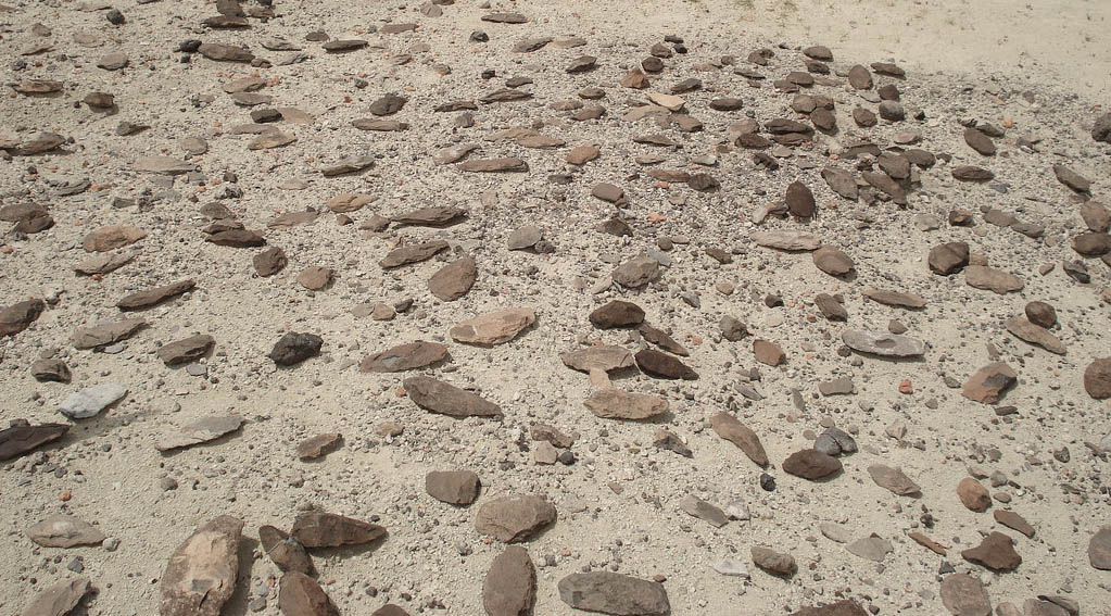
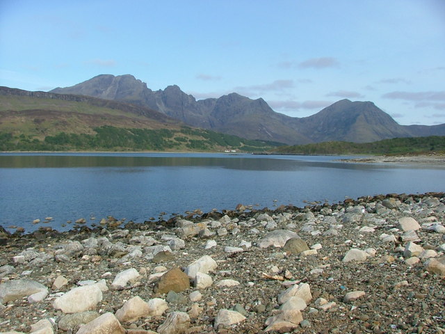
How does subduction start?

Robert Stern of the University of Texas at Dallas, USA, and Taras Gerya of ETH, Zurich, have produced a masterly review of how subduction gets started from place to place, and from time to time in geological history (Stern, R.J. & Gerya, T. 2018. Subduction initiation in nature and models: A review. Tectonophysics, v. 744 (in press); (PDF). It is the foundering of oceanic lithosphere into the mantle and gravity that give modern plate tectonics the bulk of energy that drives it along by slab pull. Yet the mantle’s consumption of a lithospheric slab somehow has to be set in motion from the symmetrical spreading of ocean floor as occurs either side of a constructive margin. It could not happen were the lithosphere to retain its low bulk density relative to mantle peridotite for all time. Moreover, it wouldn’t last for long were the lithosphere not to retain its strength through hundreds of kilometres depth as it sinks into the mantle. Active subduction zones have consumed vast amounts of oceanic lithosphere, for more than 65 million years, especially in fast-spreading ocean basins such as the western and eastern Pacific. The record is held by the destructive margin on the west flank of South America where more than 150 million years-worth of eastern Pacific lithosphere has been swallowed. Yet in order for oceanic lithosphere, which is stronger than that beneath the continents, somehow to fail and begin to sink a linear weak zone must develop at the interface between two incipient new plates. On top of that, all subduction on Earth is one-sided. A simple mechanism involving just thermal convection predicts that both plates either side of a break would have similar density so both should sink, more or less symmetrically.
subduction types
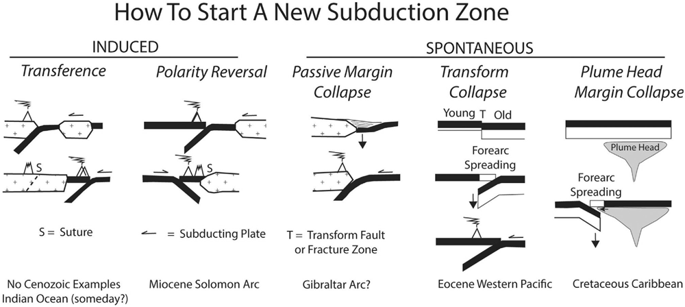
Various ways in which subduction may start. (Credit: Stern and Gerya 2018 – in press – Figure 4)

Geophysical observations reveal that terrestrial subduction can be divided into that which is induced by plate motions and changes in force balance within spreading plates, or spontaneously due to unique conditions developing along the line of initiation. In the first class are cases where a microcontinent is driven into another continental margin and extinguishes the subduction responsible, while spreading continues behind the accreted microcontinent drive older lithosphere beneath the suture (this may have happened in the past but is not seen today). Another, similar, induced case occurs where an oceanic island arc accretes by subduction beneath it so that subduction flips in polarity to consume the driving sea-floor spreading. The loading of oceanic lithosphere by sediments piled onto it by erosion of a continental margin may spontaneously collapse to result in subduction beneath the sedimentary wedge and the continent (again, not happening today, but inferred from examples inferred by earlier geological history). Spontaneous failure may also occur where old, cold lithosphere is juxtaposed with younger by transform faulting, or where a mantle plume heats up lithosphere to create a thermally weakened zone.

Stern and Gerya do not leave the issue at simple mechanics but discuss how plates may develop weak zones or inherit them from earlier tectonic events. The role of water released by metamorphism of descending materials may encourage the observed one-sidedness of subduction by reducing frictional resistance and plate strength and make the process self-sustaining. The paper also discusses the various permutations and combinations that affect the style of induced destructive margins in compressional and extensional environments and a whole variety of nuanced cases of spontaneous initiation. Numerical modelling of the subduction process plays an important, though somewhat bewildering role in discussion, as do considerations of the forces likely to be at play. Applying theoretical considerations to actual examples from the geological record are sublimely enlivening, as are speculations about the future evolution of the passive margins of the Atlantic. Clearly, there is a healthy future for field and mathematical study on the processes at destructive plate margins, such as building in the aspects of magmagenesis. Since Stern has built his career on study of long dead collusions zones, products of arc accretion etcetera, development of their understanding is undoubtedly the main thrust of his and Gerya’s tour de force. Stern provides a full PDF at his University of Texas website for the benefit of anyone who wants to delve deeper than space at Earth-pages and my limited intellect permit!

A fully revised edition of Steve Drury’s book Stepping Stones: The Making of Our Home World can now be downloaded as a free eBook

Snowball Earth: A result of global tectonic change?

The Snowball Earth hypothesis first arose when Antarctic explorer Douglas Mawson (1882-1958)speculated towards the end of his career on an episode of global glaciations, based on his recognition in South Australia of thick Neoproterozoic glacial sediments. Further discoveries on every continent, together with precise dating and palaeomagnetic indications of the latitude at which they were laid down, have steadily concretised Mawson’s musings. It is now generally accepted that frigid conditions enveloped the globe at least twice – the Sturtian (~715 to 660 Ma) and Marinoan (650 to 635 Ma) glacial episodes – and perhaps more often during the Neoproterozoic Era. Such an astonishing idea has spurred intensive studies of geochemistry associated with the events, which showed rapid variations in carbon isotopes in ancient seawater, linked to the terrestrial carbon cycle that involves both life- and Earth processes. Strontium isotopes suggest that the Neoproterozoic launched erratic variation of continental erosion and weathering and related carbon sequestration that underpinned major climate changes in the succeeding Phanerozoic Eon. Increased marine phosphorus deposition and a change in sulfur isotopes indicate substantial change in the role of oxygen in seawater. The preceding part of the Proterozoic Eon is relatively featureless in most respects and is known to some geoscientists as the ‘Boring Billion’.

Untitled-1
Artist’s impression of the glacial maximum of a Snowball Earth event (Source: NASA)

Noted tectonician Robert Stern and his colleague Nathan Miller, both of the University of Texas, USA, have produced a well- argued and -documented case (and probably cause for controversy) that suggests a fundamental change in the way the Precambrian Earth worked at the outset of the Neoproterozoic (Stern, R.J. & Miller, N.R. 2018. Did the transition to plate tectonics cause Neoproterozoic Snowball Earth. Terra Nova, v. 30, p. 87-94). To the geochemical and climatic changes they have added evidence from a host of upheavals in tectonics. Ophiolites and high-pressure, low-temperature metamorphic rocks, including those produced deep in the mantle, are direct indicators of plate tectonics and subduction. Both make their first, uncontested appearance in the Neoproterozoic. Stern and Miller ask the obvious question; Was this the start of plate tectonics? Most geologists would put this back to at least the end of the Archaean Eon (2,500 Ma) and some much earlier, hence the likelihood of some dispute with their views.

They consider the quiescent billion years (1,800 to 800 Ma) before all this upheaval to be evidence of a period of stagnant ‘lid tectonics’, despite the Rodinia supercontinent having been assembled in the latter part of the ‘Boring Billion’, although little convincing evidence has emerged to suggest it was an entity formed by plate tectonics driven by subduction. But how could the onset of subduction-driven tectonics have triggered Snowball Earth? An early explanation was that the Earth’s spin axis was much more tilted in the Neoproterozoic than it is at present (~23°). High obliquity could lead to extreme variability of seasons, particularly in the tropics. A major shift in axial tilt requires a redistribution of mass within a planetary body, leading to true polar wander, as opposed to the apparent polar wander that results from continental drift. There is evidence for such an episode around the time of Rodinia break-up at 800 Ma that others have suggested stemmed from the formation of a mantle superplume beneath the supercontinent.

Considering seventeen possible geodynamic, oceanographic and biotic causes that have been plausibly suggested for global glaciation Stern and Miller link all but one to a Neoproterozoic transition from lid- to plate tectonics. Readers may wish to examine the authors’ reasoning to make up their own minds –  their paper is available for free download as a PDF from the publishers.

A fully revised edition of Steve Drury’s book Stepping Stones: The Making of Our Home World can now be downloaded as a free eBook

Evolution of the River Nile

The longest river in the world, the Nile has all sorts of riveting connotations in terms of archaeology, Africa’s colonial history, the romance of early exploration and is currently the focus of disputes about rights to its waters. The last stems from its vast potential for irrigation and for hydropower. It is probably the most complex of all the major rivers of our planet because it stretches across so many climatic zones, topographic systems geological and tectonic provinces. Mohamed Abdelsalam of Oklahoma State University, who was born in the Sudan and began his career at the confluence of the White and Blue Nile in its capital Khartoum, is an ideal person to produce a modern scientific summary of how the Nile has evolved. That is because he has studied some of the key elements of the geology through which the river and its major tributaries travel, but most of all because he is a leading geological and geomorphological interpreter of remotely sensed data. Only space imagery can let us grasp the immense span and complexity of the Nile system. His recent review of its entirety (Abdelsalam, M.G. 2018. The Nile’s journey through space and time: A geological perspective. Earth Science Reviews, v. 177, p. 742-773; doi: 10.1016/j.earscirev.2018.01.010) is a tour de force, many years in the compilation, and it makes fittingly compulsive reading.

Abdelsalam lays out the geomorphology, underlying geology and regional tectonics of the Nile drainage basin, synthesized from publications over the last century, including his own work on the evolution of the Blue Nile in Ethiopia. On the regional scale elements of its complexity can be ascribed to the upwelling of mantle plumes beneath the Ethiopian Highlands and Red Sea, and under the Lake Plateau centred on Kenya, Tanzania, Rwanda and Burundi. These plumes are part of a much larger mantle mass rising from the core-mantle boundary beneath the African continent. Their influence on the lithosphere of north-east Africa began over 30 million years ago, producing vast outpourings of flood basalts followed by regional doming, the formation of large shield volcanoes and rifting to transform a once muted surface to one with a topographic range of up to 5 kilometres in the Nile’s two main source regions in Ethiopia and the Lakes Plateau.

Nile geology F5
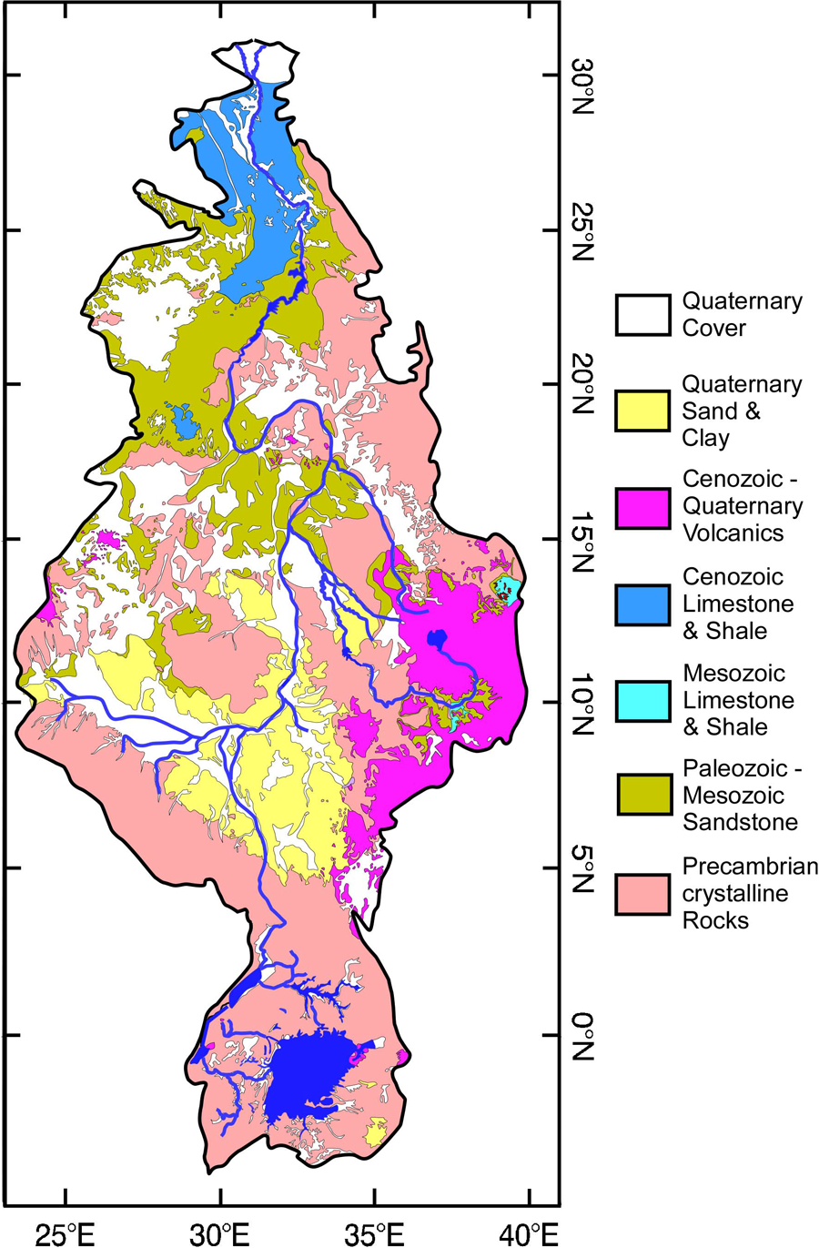
The geological underpinnings of the Nile system (Credit: Abdelsalam 2018; Fig. 5)

The basin can be divided into six distinct provinces, from south to north the Lakes, Sudd, Central Sudan, Ethiopia – East Sudan, Cataract and Egyptian Niles. Each of them has had a different history; in fact, the making of the Nile system as we know it has taken at least 6 million years and probably longer. For instance, the Lakes Nile basin, founded mostly on Precambrian crystalline basement, seems original to have drained westward through the Congo system to the Atlantic Ocean. Sometime between 20 and 12 Ma the western branch of the East African Rift System began to form along with slow, broad uplift, hindering westward flow to create the forerunners of the Great Lakes. The flow was reversed around 2.5 Ma ago by the rise of the Rwenzori and Virunga massifs on the western rift flank and eventually forced northwards into the low-lying Sudd, breaching a major divide in Northern Uganda. The vast swamps there have acted as a buffer for sediment supply, other than the finest silts and clays, into the northern stretches of the White Nile. The Blue Nile’s tortuous trajectory evolved as the Ethiopian flood basalt province rose after 30 Ma, rifted to form the Lake Tana Basin and drained to initiate erosion into the rising plateau with the interference of huge shield volcanoes that formed as uplift proceeded.

Other events are recorded along the Nile’ general trajectory by huge, abandoned alluvial fans, relics of now vanished lakes and evidence from satellite radar of palaeo-drainages with reversed flow beneath the surface of the eastern Sahara. The system evolved episodically, in five or more steps, at the whim of broad tectonic processes that affected flow direction and erosive capacity. The Cataract Nile that cuts through hard basement rocks perhaps records the increase in energy added by the Blue Nile which, which in turn may have encouraged the drainage of the huge Sudd swamps that established the White Nile’s course. Even the Mediterranean Sea played a role: the Egyptian Nile may have formed when the sea vanished to expose a deep saline basin during the Messinian Salinity Crisis 5.5 Ma ago. This reduction in the regional base level of erosion possibly directed drainage into the present course of the Nile. The various provinces only became a unified drainage system during the last half million years, and that emerged in its present form as recently as 15 thousand years ago.  But as Abdelsalam points out, there is a great deal to learn about the fabled river system. Hopefully his review will encourage others to take investigations forward and into previously unstudied regions.

The hobbits of Flores: An update

Homo floresiensis (the "Hobbit")
Homo floresiensis from Liang Bua Cave, Flores, Indonesia. (Credit: Wikipedia)

In October 2004 the world’s news media headlined the discovery of fossil remains of a tiny adult human on the Indonesian island of Flores, dated at around 18 ka. At only 1 m tall, with a brain cavity around a third the size of ours, yet having used stone tools and fire she was a sensational find. Someone so tiny and with such a small brain seemed highly unlikely to some palaeoanthropologists. Others claimed she was of a different species altogether. Homo floresiensis was also challenged as a new species and attributed to some congenital cause of small stature in a modern human – H. sapiens had first colonised Flores between 50 and 35 ka. But the subsequent discovery of remains of nine more individuals revealed skeletal details that were definitely un-human, with a suggestion of greater affinity to H. erectus. Her stature even suggested to a few anthropologists that she may have descended from migrant H. habilis, previously known only from 2 Ma ago in East Africa. The issue of relatedness was partly resolved by further dating of the cave strata that entombed the ‘hobbit’ which pushed her back to between 190 to 50 ka, beyond the earliest date of modern human colonisation. Further fragmentary fossil finds in more easily dated sediments on Flores showed the earliest known H. floresiensis lived around 700 ka ago. Stone tools and butchered prey remains on the island go back to 1 Ma, when the hominin trail goes cold.

English: Cave where the remainings of ' where ...
Liang Bua cave where the remains of Homo floresiensis were discovered in 2003. (credit: Wikipedia)

A plausible theory for these human’s ‘hobbit’-like size is an evolutionary process known as island dwarfism, akin to that which produced the tiny elephants (Stegodon) on which they preyed. Such dramatic size reduction may arise through the influence of stringently limited food resources on the evolution of descendants from a restricted founder population, genetically cut-off from larger, more widespread populations. It now appears that such dwarfism has also affected a modern human population living on Flores (Tucci, S and 14 others 2018. Evolutionary history and adaptation of a human pygmy population of Flores Island, Indonesia. Science,  v. 361, p. 511-516; doi: 10.1126/science.aar8486). A group of people of diminished stature live within shouting distance of the Liang Bua cave in which Homo floresiensis was first discovered. On average adults in the village are about 1.45 m tall. They certainly are not relict H. floresiensis, just significantly smaller than other Indonesian people living on Flores.

Serena Tucci and colleagues analysed the DNA of 32  adult pygmies from the village of Rampasasa. They show no sign of DNA from any other archaic human population than the Neanderthal and Denisovan traces that every living person outside of Africa carries – the pygmies are not descendants of H. floresiensis and are little different from other Indonesians and the rest of us. The analysis does show, however, that their ancestors carried a mixture of DNA from East Asia and New Guinea; perhaps a result of several waves of migration between 50 and 5 ka. They also carry significantly more DNA segments that are linked to short stature than do other East Asians. This suggests natural selection favored existing genes for shortness while the pygmies’ ancestors were on Flores; in other words they display an example of island dwarfism akin to that probably explaining the ‘hobbits’. Moreover, the people of Rampasasa show signs of an evolutionary adaptation to an almost exclusively meat and seafood diet, possibly arising after they migrated to Flores and had to depend on the available fauna but little in the way of plant foods.

A fully revised edition of Steve Drury’s book Stepping Stones: The Making of Our Home World can now be downloaded as a free eBook
Hot-spot track beneath the Greenland ice cap

Around 63 Ma ago, during the Palaeocene Epoch, major igneous activity broke out in what are now both sides of the North Atlantic Ocean. After initial sputtering it culminated massively between 57 and 53 Ma. Relics are to be seen in Baffin Island, West and East Greenland, the Faeroes and north-western parts of the British Islands, in the form of flood basalts, dyke swarms and scattered remnants of central volcanoes. Offshore drilling on the North Atlantic’s continental shelves suggests that the volcanism extended over 1.3 million km2 and blurted out around 6.6 million km3 of magma. Not for nothing have the products of this event been categorised as a Large Igneous Province. Its formation took place before the North Atlantic existed. It began to form as this precursor magmatic paroxysm waned.  Continued basaltic magma production created the ocean floor each side of the mid-Atlantic Ridge system to divide North America and Greenland from northern Europe. Sea floor spreading continues, rising above sea level in Iceland, which is underlain by a large mantle plume.

The plume beneath Iceland may have been present at a fixed position in the mantle for tens of million years. A hot spot over which plate movements have shifted lithosphere to be heated in a similar way to a sheet of paper dragged slowly over a candle flame. The Iceland plume may have left a hot-spot track similar to that involved in the Hawaiian island chain. The ocean floor to the east and west of Iceland is shallower and forms broad rides at right angles to the trend of the Mid-Atlantic Ridge system, judged to be such tracks that are still warm and buoyant after formation over the plume. But are there traces of earlier passage of drifting lithosphere over the plume. A way to detect older hot-spot tracks is through variations in geothermal heat flow through the continental surface, a linear pattern raising suspicions of such trace of passage. There is no sign to the east beneath Europe, so what about to the west. Greenland, being mainly blanketed in ice, is not a good place to conduct such a search as it would involve deep drilling through the ice at huge cost for each hole. But there is a roundabout way of obtaining geothermal information without even setting foot on Greenland’s icy wastes.

The geomagnetic field measured at the surface records anomalies in rock magnetisation in the solid Earth beneath. Near-surface variations due to large variations in rock types that comprise the continental crust appear as sharp, high frequency signals. Aeromagnetic surveys over Greenland are characterised by such noisy patterns because the subsurface geology is extremely complicated. However, the underlying upper mantle beneath all continents is geologically quite bland, but being uniformly rich in iron it contains a high proportion of magnetic minerals such as magnetite (Fe3O4). The upper mantle should therefore leave a signal in the surface geomagnetic field, albeit a commensurately bland one. Like radio signals that span a large range of wavelengths, Earth properties that vary spatially, such as the geomagnetic field, may be analysed using filters. Once the high-frequency geomagnetic features of the crust are filtered out what should remain is a signal that reflects the magnetic structure of the upper mantle. It should be more or less featureless, yet beneath Greenland it isn’t.

greenland hot spot
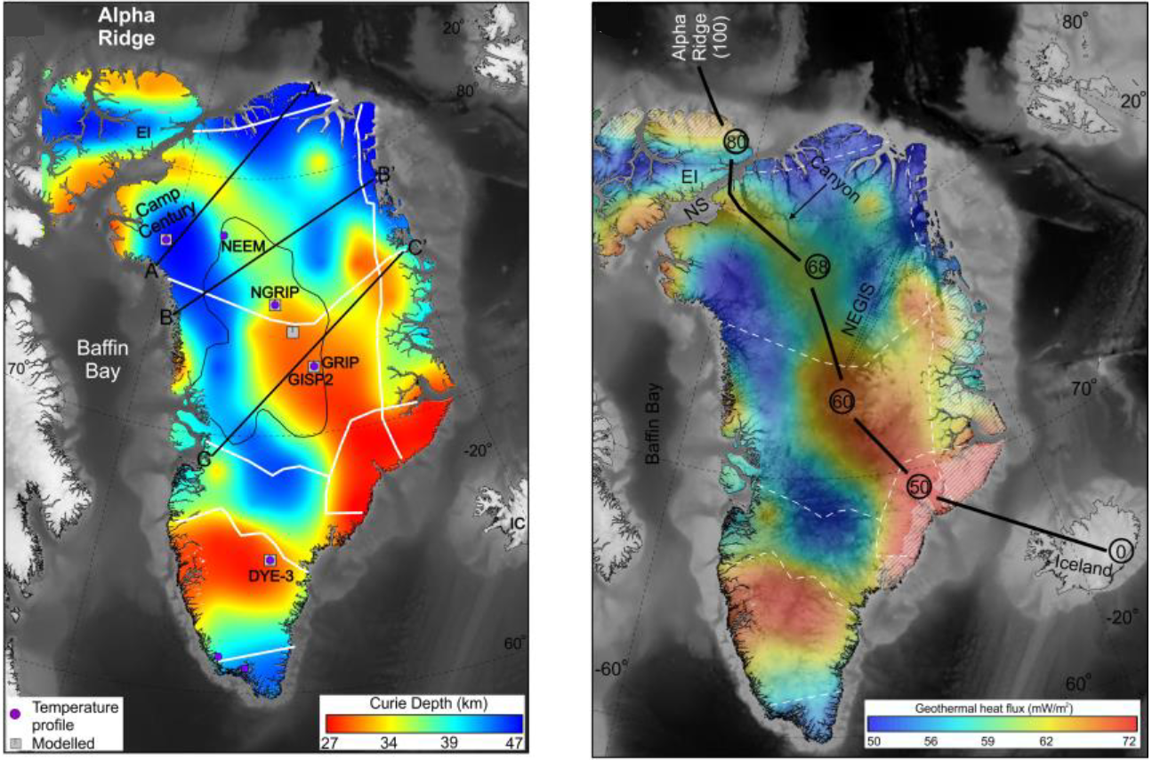
Estimated Curie depth variation below Greenland (left) converted to geothermal heat flow variation (right). (Credit: Martos et al. 2018; Figures 1b and 1c)

Magnetic anomalies are created by magnetisation induced in magnetic minerals in rocks by the Earth’s magnetic field. Yet minerals lose their ability to be magnetised at temperatures above a threshold known as the Curie point, which is 580 °C for magnetite, the most abundant magnetic mineral. Depending on the geothermal heat flow the Curie point is exceeded at some depth in the lithosphere. So magnetic anomalies can safely be assumed to be produced only by rocks above the so-called Curie depth. Yasmina Martos of the British Antarctic Survey (now at the University of Maryland) and scientists from Britain, the US and Spain used a complex procedure, including gravity data and a few direct measurements of heat flow below Greenland as well as filtered aeromagnetic data, to estimate the variation in Curie depth beneath the ice cap. (Martos, Y.M. et al. 2018. Geothermal heat flux reveals the Iceland hotspot track underneath Greenland. Geophysical Research Letters, v. 45, online publication; doi: 10.1029/2018GL078289). Using that as an inverse proxy for heat flow they were able to map the likely geothermal variation beneath the island. Rather than a random and narrow variation in depth, as would be expected for roughly uniform heat flow, the Curie depth varied in a non-random way by over 20 km, equivalent to roughly 20 mW m-2.

The shallowest Curie depth and highest estimated heat flow occurs in East Greenland around Scoresby Sund where the largest sequence of Palaeocene flood basalts occur. It is also on a line perpendicular to the mid-Atlantic Rift system that meets the active Iceland plume. Running north-west from Scoresby Sund is a zone of locally high estimated heat flow. Martos et al. suggest that this is the track of Greenland’s motion over the Iceland hot spot from about 80 Ma to the period of maximum on-shore volcanism and the start of sea-floor spreading at around 50 Ma.

A fully revised edition of Steve Drury’s book Stepping Stones: The Making of Our Home World can now be downloaded as a free eBook

The Great Barrier Reef and the Last Glacial Maximum (LGM)

The 2,300 km stretch of coral reefs and islands in the Coral Sea off the coast of Queensland, Australia is the largest single structure on Earth built by living organisms. The dominant reef builders are four hundred species of coral, most of which are a symbiosis that conjoins marine invertebrates in the class Anthozoa – part of the phylum Cnidaria – and photosynthesising single-celled eukaryotes known as dinoflagellates. These algae are mainly free-living marine plankton, some species of which evolved to be co-opted by corals. Their role in the symbiosis is complex; on the one hand providing energy in the form of sugars, glycerol and amino acids; on the other consuming the coral polyps’ carbon dioxide output. The latter is fixed, in the case of hard corals, by the secretion of calcium carbonate: the key to reef formation.

Marine photosynthesisers demand clear water in the upper few tens of metres of the sea, together with sunlight least affected by the atmosphere, as in the tropics where the sun rises to the zenith year round. The coral animal-algae connection limits reef growth to shallow seas, the top of the reef being close to mean sea level, sometimes rising above it at low tide. Hence the formation of fringing and barrier reefs. In the case of atoll reefs, a connection with sea-floor volcanoes that rose from hotspots on the oceanic abyssal plains to form active volcanic islands that began to sink once they became extinct. The pace at which reefs can grow is generally able to match that of crustal subsidence so that atolls remain throughout the Western Pacific. Reef growth is also capable of coping with global sea-level changes, so that the present top level of the Great Barrier Reef has been in balance with the generally static sea level of the Holocene since the ice caps of the last glaciation melted back to roughly their present extent about seven thousand years ago.

There are many cases of different reef levels on and around islands that match the sea-level fluctuations during the last Ice Age.  High-resolution bathymetry produced by multi-beam sonar across the eastern edge of parts of the Great Barrier Reef reveals a series of submerged terraces down to almost 120 m below modern sea-level (Yokoyama, Y. and 17 others 2018. Rapid glaciation and a two-step sea level plunge in the Last Glacial Maximum. Nature, v. 559, p. 603-607; doi:10.1038/s41586-018-0335-4). Globally, the LGM began at around 31 ka when sea level fell by about 40 metres, thanks to massive accumulation of glacial ice at high latitudes. Previous studies to chart the changes in global mean sea level during the LGM suggested a steady fall until about 20 ka, followed by rapid rise as ice caps melted back. The multinational team led by Yusuke Yokoyama of the University of Tokyo, obtained precise ages of coral samples from different depths in drill cores through the coral terraces. These data revealed a more complex pattern of sea-level change, in particular a hitherto unsuspected plunge between 21.9 and 20.5 ka of 20 m to reach -118 m. This immediately preceded the warming-related rise that continued to Holocene levels.

GBR Bathymetry
High-resolution sonar images of the sea floor at two sites on the eastern edge of Australia’s Great Barrier Reef. They show terraces associated with, the lowest of which corresponds to the Last Glacial Maximum. (Credit: Yokoyama et al. 2018, Figure 1)

Curiously, this massive phenomenon is not shown by sea-level estimates derived from the records of changing oxygen isotopes in ocean-floor sediments and ice cores. The team’s complex modelling incorporated global changes in land and sea-bed levels, and thus changes in the volume of the ocean basins, due to the changing isostatic effects of both ice-cap and ocean masses. From these it is possible to reach an interesting conclusion (Whitehouse, P. 2018. Ancient ice sheet had a growth spurt. Nature, v. 603, p. 487-488; doi:10.1038/d41586-018-05760-3). Rather than an increase in snowfall onto ice-caps, their retreat may have been hindered by thickening of marginal floating ice shelves that created buttresses around Antarctica and the northern ice sheets. Slowed glacial flow to the oceans could have promoted ice sheet growth for a time as melting of calved icebergs was hindered, especially in the case of the ice sheet over northern North America. Certainly, this crucial climatic turning point was a lot more complex than previously believed.

Technical problem with Earth-pages News

Followers of Earth-pages News have been unable to access the site for more than three weeks due to a technical problem that disabled the earth-pages.co.uk link. The fault has been found and remedied. Apologies for the loss of service.

Steve Drury

The earliest humans to leave Africa, in China

Since discovery in 2010 that remains of the genus Homo at Dmanisi in Georgia were about 1.85 Ma old several more instances of bones and stone tools a few hundred thousand years less than that age have turned up in China. All have been ascribed to H. erectus, although there are dissimilarities with African examples of the species and its predecessor H. ergaster. The technological breakthrough that led H. erectus/ergaster to knap the distinctive bifacial or Acheulean ‘handaxe’ was achieved at about the same time as the Dmanisi humans left Africa, yet there is no sign of such tools in eastern Asia until much later, most ancient artefacts there being of a more primitive, ‘Oldowan’ type. That is perhaps because more serviceable tools were fashioned from less durable materials than fine-grained rock that takes an edge. Maybe the skills were lost en route or the forebears of eastern Asian tool makers left Africa before the breakthrough. At any rate, the genus Homo is generally conferred on any being that had a tool-making culture, so that the presence of tools alone in a sedimentary deposit signifies that humans probably once inhabited that site. The earliest tools (3.3 Ma) from the Turkana area of Kenya were made half a million years before the first known appearance of well-documented remains of an un-named member of the genus Homo at  Ledi-Geraru in Afar, Ethiopia (2.8 Ma). At sites in Olduvai, Tanzania (1.9 Ma) and Turkana, Kenya (2.1 Ma) fossils of Homo habilis are found in association with ‘Oldovan’ stone tools.

Sites where early human fossils an tools have been found. (Credit: John Kappelman, Nature 2018; doi:10.1038/d41586-018-05293-9)

The latest development in the origin and wanderings of early humans has emerged from studies of a thick deposit of windblown silt or loess that makes up the Loess Plateau (Latitude 34°N) between the Yellow and Yangtze Rivers in central-east China. The loess is divided into several sequences by thin soil horizons (palaeosols). The entire stratigraphy contains tiny grains of iron minerals whose magnetic polarity was aligned with the Earth’s magnetic field at the time of deposition. This allows periods of normal and reversed geomagnetic polarity to be detected with considerable precision. Measurements have been taken at 10 cm intervals throughout the loess, to give an unbroken record of events throughout the Pleistocene Epoch that can be matched to a dated reference called the geomagnetic polarity timescale (GPTS). Palaeoclimate researchers have been able to show that the layers of loess correspond to successive glacial stages, whereas the palaeosol represent warm interglacials, exactly as recorded in sea-floor sediment profiles   A team of archaeologists from China and Britain have found primitive, Oldowan-type, artefacts in both the loess and palaeosol horizons at 17 different levels (Zhu, Z. and 10 others 2018. Hominin occupation of the Chinese Loess Plateau since about 2.1 million years ago. Nature, v. 559 advance publication online doi:10.1038/s41586-018-0299-4. See also). The artefacts are positioned at levels dated at between 1.26 to 2.12 Ma by the palaeomagnetic dating (from the Réunion to Cobb Mountain normally polarized subchrons).

Primitive stone tool (four sides shown) from the Loess Plateau of China. (Credit: Zhu et al./Nature 2018)

So, in both cool and warm conditions (34°N has cold winters today) toolmakers were regularly present in central, east China for almost 900 ka. The earliest must have made a 14 thousand km trek from tropical Africa across several climatic zones, and been physically, cognitively and technologically capable of surviving and reproducing for the one- to three-thousand years the journey must have taken (based on a dispersal rate of 5 to 15 km a year estimated from modern hunter-gatherers’ activities). Either there were repeated migrations of this scale or a pioneer population survived on or within reach of the loess steppe for hundreds of thousand years. The earliest emigrants would have been neither Homo erectus nor ergaster, for neither had evolved. Their age suggests that they may have been H. habilis, a view that has been expressed for the ancestors of the diminutive H. floresiensis known to have been present of the Indonesian island of Flores for around 700 ka. Until actual fossils are unearthed – not easy as the sequence is exposed in very steep slopes characteristic of dissected loess terrains – who the first occupants of China were remains mysterious. But one thing stands out: If early humans from that long ago could arrive, survive and prosper half a world away from their place of origin, then paleoanthropologists must consider the possibility of continual diffusion of the genus Homo away from its African origins once equipped with the ability to make tools. China may become the focus for early-human research as it became for that into the origins of birds and feathered dinosaurs.

You can read more about early humans and their evolution here.

A fully revised edition of Steve Drury’s book Stepping Stones: The Making of Our Home World can now be downloaded as a free eBook

A new kind of seismology

The detection and analysis of earthquake waves has played a major role in the study of how the Earth works for more than a century. Seismology has laid bare the deep structure of our planet. Using records from seismographs that showed the arrival times at different sites of body waves propagated by a 1909 earthquake near Zagreb Croatian scientist Andrija Mohorovičić deduced that the upper Earth was layered. His name is given to the boundary between the crust and underlying mantle; the Mohorovičić Discontinuity (Moho for short). Applying the principles of wave reflection and refraction to wave-arrival times from major seismic events at seismographic stations across the Earth’s surface resulted in the discovery of deeper discontinuities in the mantle and the structure of the core. As the number of stations increased, largely as a result of the need to detect and pin-point tests of nuclear weapons, reversing the principles enabled the 3-D positions of lesser events to be plotted. The resulting swathes of seismicity defined the boundaries of tectonic plates, and from the varying depths at which earthquakes occurred came ideas about their nature; especially important for the mapping of subduction zones. Expansion and standardisation of the global seismographic network and the millions of records that it has produced, together with advances in their digital analysis, has created the current method of charting deep-Earth properties using seismic tomography. A remarkable outcome of such studies is the strikingly named ‘The Atlas of the Underworld’.

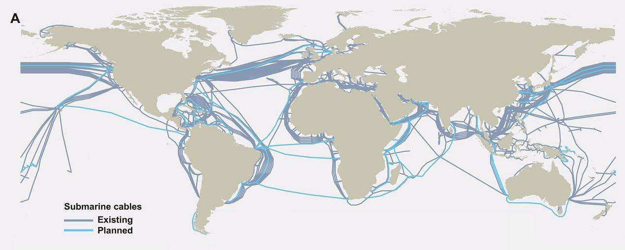
Up to now there has been a limit to the scope of such studies, particularly their resolution of features in the Earth’s mantle. Almost all the recording stations are on land, leaving the 70% of the surface covered by oceans devoid of data. Yet that might be set to change. The building of the Internet’s World Wide Web has largely depended on a growing network of telecommunications optic-fibre cables that criss-cross the oceans as well as the continents, stretching about a million kilometres. Using lasers at each end of a cable and interferometric analysis of two light signal that takes up a tiny proportion of the cable’s bandwidth it is possible to detect noise due to disturbances of the cable that result from earthquakes. On land this is compromised by local effects, such as traffic noise, but the ocean floors are remarkable quiet. Giuseppe Marra of Britain’s National Physical Laboratory discovered the potential of using optic fibre while testing a 79 km length cable linking atomic clocks at NPL and Reading (Marra, G. And 11 others 2018. Ultrastable laser interferometry for earthquake detection with terrestrial and submarine cables. Science online publication; doi:10.1126/science.aat4458). Purely by chance he observed unusually high spikes in noise during 2016. By no stretch of the imagination could they have been caused by events along the course of the cable. Curious, he eventually tracked the signals down to a series of earthquakes beneath Norcia in central Italy that cause death and destruction between 24 August and 30 October 2016. With a magnitude of 6.5, the last was the largest seismic event in Italy for 36 years. Subsequently, he and colleagues picked up the signal of a far less energetic event beneath the Mediterranean Sea (magnitude 3.4) from a cable linking Malta and Sicily.

F1.large
Map of submarine optic-fibre cables (credit: TeleGeography’s Telecom Resources)

With records from three suitably equipped cables an earthquake focus could be located precisely using triangulation. Together with the recorded signals, it would also be possible to use high magnitude earthquakes detected by optic-fibre cables to add to conventional seismic tomography, thereby sharpening the 3-D images of the deep Earth, which at present are plagued by blurring of much useful detail. Since both submarine and terrestrial cables might be used, such a method may become a bonanza for geophysicists

See also: Hand, E, 2018. Seafloor fibre optic cables can listen for earthquakes. Science, v. 360, p. 1160.

A fully revised edition of Steve Drury’s book Stepping Stones: The Making of Our Home World can now be downloaded as a free eBook

A hint of life on Mars

We can be certain that life was around on Planet Earth around 3.5 billion years ago, if not before, because unmetamorphosed sedimentary rocks of that age from Western Australia in which stromatolites occur contain a black to brownish, structureless material known as kerogen. The material is a hodgepodge of organic compounds that form during the breakdown of proteins and carbohydrates in living matter. It is the source material for petroleum compounds when kerogen-rich rocks are heated during burial. The vast bulk of organic compounds preserved on Earth are in the form of ancient kerogen, whose mass exceeds that of the living biosphere by about 10 thousand times. A good sign that it does represent ancient life lies in sedimentary kerogen’s depletion in ‘heavy’ 13C compared with 12C (negative values of δ13C), because in metabolising carbon dioxide living cells preferentially use the lighter of these two isotopes. Conceivably, 13C can be removed from inorganic carbon by metamorphic processes, so low values of δ13C in metasediments from West Greenland might be organically derived or, equally, they might not.

At the time of writing, geoscientists specialising in Martian matters had become excited by some results from the geochemical system aboard the surviving functional NASA rover. Curiosity has slowly been making its way up Mount Sharp at the centre of Gale Crater near to Mars’s equator. Analysis of high-resolution images taken from orbit suggest that the rocks forming the mountain are sediments. the lowest and oldest strata are suspected to have been deposited in a crater lake when conditions were warmer and wetter on Mars, about 3 billion years ago. Curiosity was equipped with a drill to penetrate and sample sediment unaffected by ultraviolet radiation that long ago would have destroyed any hydrocarbons exposed at the surface. In late 2016, before the rover had reached the lake sediments, the drill’s controller broke down. Since then, Curiosity had moved on to younger, less promising sediments. More than a year later mission engineers fixed the problem and the rover backtracked to try again. Heating the resulting samples to almost 900°C yields any volatile components as a gas to a mass spectrometer, results from which give clues to the molecules released.

‘Selfie’ of Curiosity rover en route to Mount Sharp. (Credit: NASA)

The Sample Analysis at Mars (SAM) team report a range of thiophenic, aromatic and aliphatic molecules of compounds of carbon, hydrogen and sulfur (Eigenbrode, J.L and 21 others 2018. Organic matter preserved in 3-billion-year-old mudtsones at Gale crater, Mars. Science, v. 360, p. 1096-1101; doi:10.1126/science.aas9185). The blend of pyrolysis products closely resembles those which form from heated terrestrial kerogens and coals, but also from pyrolysis of carbonaceous chondrite meteorites. So, the presence of Martian kerogen is not proven. But the results are so promisingly rich in hydrocarbons that another weapon in SAM’s armoury will be deployed, dissolving organic compounds directly from the drill cuttings. This may provide more convincing evidence of collagen. Yet only when samples are returned to labs on Earth will there be a chance to say one way or the other that there was once life on Mars. The results reported in Science’s 8 June issue will surely add weight to the clamour for the Mars 2020 sample-return mission to be funded. Whether or not there is life on Mars demands a great deal more investment still…

A fully revised edition of Steve Drury’s book Stepping Stones: The Making of Our Home World can now be downloaded as a free eBook

The great Cambrian unconformity

My first field trip from the Geology Department at the University of Birmingham in autumn 1964 was located within hooter distance of the giant British Leyland car plant at Longbridge. It involved a rubbish-filled linear quarry behind a row of shops on the main road through south Birmingham. Not very prepossessing but it clearly exposed a white quartzite, which we were told was a beach deposit laid down by a massive marine transgression at the start of the Cambrian. An hour later we were shown an equally grim exposure of weathered volcanic rocks in the Lickey Hills; they were a sort of purple brown, and said to be Precambrian in age. Not an excellent beginning to a career, but from time to time other Cambrian quartzites sitting unconformably on Precambrian rocks entered our field curriculum: in the West Midlands, Welsh Borders and much further afield in NW Scotland, as it transpired on what had been two separate continental masses of Avalonia and Laurentia. This had possibly been a global marine transgression.

In North America, then the Laurentian continent, what John Wesley Powell dubbed the Great Unconformity in the Grand Canyon has as its counterpart to the Lickey Quartzite the thrillingly named Tonto Group of the Lower Cambrian resting on the Vishnu Schists that are more than a billion years older. Part of the Sauk Sequence, the Tonto Group is, sadly, not accompanied by the Lone Ranger Group, but the Cambrian marine transgression crops out across the continent. In fact it was a phenomenon common to all the modern continents. Global sea level rose relative to the freeboard of the continents then existing. A recent study has established the timing for the Great Unconformity in the Grand Canyon by dating detrital zircons above and below the unconformity (Karlstrom, K, et al. 2018. Cambrian Sauk transgression in the Grand Canyon region redefined by detrital zircons. Nature Geoscience, v. 11, p. 438-443; doi:10.1038/s41561-018-0131-7). Rather than starting at the outset of the Cambria at 542 Ma, the marine transgression was a protracted affair that began around 527 Ma with flooding reaching a maximum at the end of the Cambrian.

Extensive flooding of the continents at the end of the Cambrian (credit: Ron Blakey , Colorado Plateau Geosystems)

It seems most likely that the associated global rise in sea level relative to the continents was a response to the break-up of the Rodinia supercontinent by considerable sea-floor spreading. The young ocean floor, having yet to cool to an equilibrium temperature, would have had reduced density so that the average depth of the ocean basins decreased, thereby flooding the continents. The creation of vast shallow seas across the continents has been suggested to have been a major factor in the explosive evolution of Cambrian shelly faunas, partly by expanding the range of ecological niches and partly due to increased release of calcium ions to to seawater as a result of chemical weathering.

A fully revised edition of Steve Drury’s book Stepping Stones: The Making of Our Home World can now be downloaded as a free eBook
Humans and mass extinction

It is often said that the biosphere is currently undergoing species losses that may rival those of the ‘Big Five’ mass extinction, with the rate of new extinctions being estimated at about 100 times the background rate during geological time. Scientifically, this is probably a dodgy assumption for palaeobiologists simply do not have the evidence to suggest what such a ‘normal’ rate might be. The fossil record is notoriously incomplete for a whole variety of reasons largely to do with both preservation and fossil collection strategies. For instance, as today, some genera may have been very common and widespread in past times, whereas others rare and restricted to small ecological niches. The record of life is prone to huge errors so that only huge, global shifts in diversity, such as mass extinctions, can be viewed with statistical rigour; and then only with caveats. For sure, the rapid demise of species today is cause for alarm and dismay, and more taxa – mainly of smaller and more restricted groups – probably have escaped identification, and will continue to do so. In the context of growing human impacts on ecosystems across the globe extinction is an increasingly emotive topic, as witness the clamour among some geoscientists for adding a new Anthropocene Epoch to the to the Stratigraphic Column. Does that require renaming the Holocene, beginning 11,700 years ago at the end of the last Ice Age, during which agriculture began? Should its start be assigned to some event during recorded history, such as the European invasion of the Americas after 1493, the beginning of the Industrial Revolution or the explosion of the first thermonuclear weapons in the 1940s and 50s? Or did humans begin significantly to affect the biosphere once their spread from Africa started after about 130 ka ago, i.e. in the late Pleistocene? That argument may well run and run: it is foremost a scientific issue, to which rules apply. A cogent example is that of the fate of megafaunas on the major continents except Antarctica as humans migrated far and wide.

The demise of the large flightless birds of Madagascar and New Zealand form a well known case as they almost certainly followed first colonisation by humans around 200 BC and 1300 CE respectively. The megafaunas of the much larger continents of Australia and the Americas have been deemed to have been more than decimated in the same way after about 65 ka and 15 ka respectively. There are no longer giant armadillos and ground sloths in South America, mammoths ceased to roam North America, and giant wombats, marsupial predators and kangaroos only remain as bones, to name but a few. It has been argued that their extinctions stemmed from the first human migrants literally eating their way through vast terrains. Yet the vast herds of Africa seem not to have been affected in the same way, until much more recently as population grew and modern projectile weapons became widely available. That has been suggested to have resulted from co-evolution of humans and megafauna over two million years, together with instinctive caution among large African beasts, whereas the ‘naivety’ of their counterparts in the Americas and Australia doomed them to extinction. Of course, it is likely that things were a great deal more complicated in every case, as argued in a review of Late Pleistocene megafaunal extinctions by Gilbert Price of the University of Queensland, and colleagues from Australia, the US and Denmark (Price, G.J. et al. 2018. Big data little help in megafauna mysteries. Nature, v. 558, p. 23-25;  doi:10.1038/d41586-018-05330-7).

The gist of Price and colleagues’ critique of meta-analyses of data – 32 since 1997 – concerning allegedly human-induced extinctions is that much of the pertinent data is either low quality or poorly understood. For starters, much of the dating is questionable, either using inaccurate and outdated methods or based on inference. For instance, fossils of some alleged victim, e.g.  Australian land crocodiles (Quinkana) and giant wombats (Ramsayia), have never been dated. Moreover, dates of the last known fossils are used when they may have remained extant until more recently: wooly Eurasian mammoths were long supposed not to have survived the last glacial maximum, yet recently mammoth bones from Wrangel island were found to be as young as the second millennium BCE. In 2010 spores of the fungus Sporormiella, in sediment cores, which grows only on digested plant matter in herbivore dung, was used as a proxy for the former presence or absence of large herbivore herds. Its decline in sediments after 13 ka in North America happened to coincide roughly with the start of the North American Clovis hunter culture, which was used to show that extinctions of large herbivores were linked to human predation. Yet such fungi also live on excrement of many animals both large and small, and its preservation is affected by changes in climate and water flow. To properly link declines and extinctions in human prey animals requires concrete evidence of predation, such as cut marks on identifiable bones within middens associated with human habitation, such as hearths.

When emotion, ambition and bandwagon tendencies become associated with science, objectivity sometimes gets compromised.

A fully revised edition of Steve Drury’s book Stepping Stones: The Making of Our Home World can now be downloaded as a free eBook

Sea-level rise following a Snowball Earth

The Cryogenian Period (850 to 635 Ma) of the Neoproterozoic is named for the intense glacial episodes recorded in strata of that age. There were two that palaeomagnetism  in glaciogenic sedimentary rocks indicates that ice covered all of the continents including those in the tropics, and a third, less extreme one. These episodes, when documented in the 1990s, became dubbed, aptly enough, as ‘Snowball Earth’ events. But evidence for frigidity does not pervade the entire Cryogenian, the glacial events being separated by long periods with no sign anywhere of tillites or glaciomarine diamictites shed by floating ice. Each Snowball Earth episode is everywhere overlain by thick carbonate deposits indicating clear, shallow seas and a massive supply of calcium and magnesium ions to seawater. The geochemical change is a clear indicator of intense chemical weathering of the exposed continents. The combination of Ca and Mg with carbonate ions likewise suggests an atmosphere rich in carbon dioxide. For frigidity episodically to have pervaded the entire planet indicates a distinct dearth of the greenhouse gas in the atmosphere during those events. The likely explanation for Snowball Earths is one of booms in the abundance of minute marine organisms, perhaps a consequence of the high phosphorus levels in the oceans during the Neoproterozoic when seawater was alkaline. The carbon-isotope record suggests that there were periodic, massive bursts of organic matter that would have drawn down atmospheric CO2, which coincide with the evidence for global frigidity, although marine life continued to flourish.

Artist’s impression of the glacial maximum of a Snowball Earth event (Source: NASA)

Under such ice-bound conditions the build-up of continental glaciers would have resulted in huge falls in global sea level, far exceeding the 150 m recorded during some late-Pleistocene glacial maxima. The end of each Snowball Earth would have led to equally dramatic rises and continental flooding. Such scenarios are well accepted to have occurred when accumulation of volcanic CO2 during full ice cover reached a threshold of global warming potential that could overcome the reflection of solar radiation by the high albedo of ice extending to the tropics. That threshold has been estimated to have been between 400 to 500 times the CO2 content of the atmosphere at present. Yet it has taken an intricate analysis of sedimentary structures that are commonplace in marine sediments of any age – ripple marks – to quantify the pace of sea-level rise at the end of a Snowball Earth event (Myrow, P.M. et al. 2018. Rapid sea level rise in the aftermath of a Neoproterozoic snowball Earth. Science, v. 360, p. 649-651; doi:10.1126/science.aap8612).

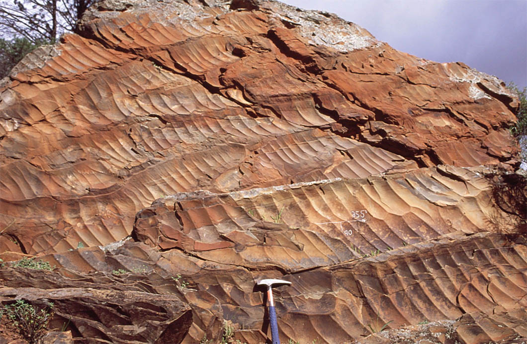
The Elatina Formation of South Australia, deposited during the Marinoan (~635 Ma) glaciation, is famous for the intricacy of its sedimentary structures especially in the clastic sedimentary rocks beneath the cap carbonate that marks the end of glacial conditions. Among them are laminated silts and fine sands that were originally thought to be the equivalent of modern varved sediments that form annually as lakes or shallow seas freeze over and then melt with the seasons. Since they contain ripple marks the laminates of the Elatina Formation clearly formed as a result of current flow and wave action – the sea surface was therefore ice free while these sediments accumulated. Careful study of the larger ripples, which are asymmetrical, shows that current-flow directions periodically reversed, suggesting that they formed as a result of tidal flows during the bi-monthly cycle of spring and neap tides in marine deltas. Data from experiments in wave tanks shows that the shapes (expressed as their amplitude to wavelength ratio) of wave ripples depend on the orbital motion of water waves at different depths. The smaller ripples are of this kind. So Myrow and colleagues have been able to tease out a time sequence from the tidal ripples and also signs of any variation in the water depth at which the smaller wave ripples formed.

Ripples on a bedding surface in the Elatina Formation, South Australia. They formed under the influence of tidal current flow. (Credit, University of Guelph, https://atrium.lib.uoguelph.ca/xmlui/handle/10214/9367?show=full)

Just over 9 metres of the tidal laminate sequence that escaped any erosion was deposited in about 60 years, giving a sedimentation rate of 27 cm per year. This is extremely high by comparison with those in any modern marine basins, probably reflecting the sediment-charged waters during a period of massive glacial melting. Throughout the full 27 m sequence smaller, wave ripples consistently show that water depth remained between 9 to 16 m for about a century. Over such a short time interval any tectonic subsidence or sag due to sediment load would have been minuscule. So sea-level rise kept pace with deposition; i.e. at the same rate of 27 cm per year. That is at least five times faster than during any of the Pleistocene deglaciations and about a hundred times faster than sea-level rise today that is caused by melting of the Greenland and Antarctic ice caps and thermal expansion of ocean water due to global warming. It has been estimated that the Marinoan ice sheets lowered global sea level by between 1.0 to 1.5 km – ten times more than in the last Ice Age – so deglaciation to the conditions of the cap carbonates, shallow, clear seas at around 50°C, would have taken about 6,000 years at the measured rate.

To read more on the Snowball Earth hypothesis and other early glacial epochs click here

A fully revised edition of Steve Drury’s book Stepping Stones: The Making of Our Home World can now be downloaded as a free eBook

Late Palaeozoic glacial features in Chad

The longest and most extreme glacial epoch during the Phanerozoic took place between 360 and 260 Ma ago, when it dominated the Carboniferous and Permian sedimentary sequences across the planet. On continents that lay athwart the Equator during these times, sedimentation was characterised by cycles between shallow marine and terrestrial conditions. These are epitomised by the recurring ‘Coal-Measure’ cyclothem of, from bottom to top: open-sea limestone; near-shore marine mudstone; riverine sandstone; coal formed in swamps. This sequence represents a rapid rise in sea level as ice sheets melted, sustained during an interglacial episode and then falling sea level as ice once again accumulated on land to culminate in a glacial maximum when coal formed in coastal mires. During the Late Palaeozoic Era a single supercontinent extended from pole to pole. The break-up of Pangaea was charted by Alfred Wegener in 1912, partly by his using glacial deposits and ice-gouged striations on the southern continents. With the present widely separated configuration of major landmasses glacial sediments and the directions of inferred ice movements could only be reconciled by reassembling Africa, India, South America, Antarctica and Australia in the form of a single, congruent southern continent that he called Gondwanaland. In Wegener’s reconstruction the glacial features massed together on Gondwanaland with the striations radiating outwards from what would then have been the centre of a huge ice cap.

There are many localities on the present southern continents where such striations can be seen on the surface of peneplains etched into older rocks that underlie Carboniferous to Permian tillites, but later erosion has removed the continuity of the original glacial landscape. There are, however, some parts of central Africa where it is preserved. By using the high-resolution satellite images (with pixels as small as 1 m square) that are mosaiced together in Google Earth, Daniel Paul Le Heron of Royal Holloway, University of London has revealed a series of 1 to 12 km wide sinuous belts in a 6000 km2 area of eastern Chad that are superimposed unconformably on pre-Carboniferous strata (Le Heron, D.P. 2018. An exhumed Paleozoic glacial landscape in Chad. Geology, v.46(1), p. 91-94; doi:10.1130/G39510.1). They comprise irregular tracts of sandstone to the south of a major Carboniferous sedimentary basin. Zooming in to them (try using 17.5° N 22.25°E as a search term in Google Earth) reveals surfaces dominated by wavy, roughly parallel lines. Le Heron interprets these as mega-scale glacial lineations, formed by ice flow across underlying soft Carboniferous glacial sediments as seen in modern glacial till landforms in Canada. In places they rest unconformably on older rocks, sometimes standing above the level of the sandstone plateaux as relics of what may have been nunataks. There are even signs of elliptical drumlins.

An oblique Google Earth view looking to the south-east shows mega-scale glacial lineations from a glacial flow way in eastern Chad. The lower-right quadrant shows the unconformity atop older bedded strata that are dipping to the west. Click on the image to see a full resolution view. (Credit: Google Earth)

Glacial tillites and glaciofluvial sediments of Late Palaeozoic age are common across the Sahara and in the Sahelian belt, but in areas as remote as those in eastern Chad. So a systematic survey using the resolving power of Google Earth may well yield yet more examples. It is tedious work in such vast areas, unless, of course, one bears in mind Alfred Wegener, the founder of the hypothesis of continental drift and ‘Big’ Earth Science as a whole, who would have been gleeful at the opportunity.

A fully revised edition of Steve Drury’s book Stepping Stones: The Making of Our Home World can now be downloaded as a free eBook

Neanderthals on the BBC

Since it began in 2000 Earth-Pages News has been covering the emergent science concerning the Neanderthals. To say that it has been a fertile field would be a considerable understatement, and I am certain that it will continue to be so. The first EPN item to mention them concerned the British Channel 4 TV documentary Neanderthals. In it I quoted Steve Jones FRS, former Head of the Department of Genetics, Evolution and Environment at University College London, who is always good for a humorous take on his science, and much more besides. ‘If you met an unwashed Cro Magnon dressed in a business suit on the Underground, you would probably change seats.  If you met a similarly garbed Neanderthal, you would undoubtedly change trains’. That they had the build of world-champion freestyle wrestlers, beetling brows and extremely large noses was illustrated in the programme by reconstructions based on their skeletal remains; yes, they did look  dangerous. But Jones’s theory is put to the test with a suitably attired actor made up as a Neanderthal man in new two-part series on BBC2, Neanderthals – Meet Your Ancestors (follow the link to watch the first programme – you need to create an account at BBC iPlayer and claim that you do have a British TV licence). Some commuters did give the chap a slightly worried glance, but there was not a rush for the doors. Ella Al-Shamahi, one of the presenters, even commented that some of her friends may well have actively sought a date with him! He certainly did not seem out of place in cosmopolitan London, and the same might be said for a cattle auction in rural Cumbria. On the New York subway he would undoubtedly have been ignored. Steve Jones was wrong!

An actor made-up to resemble a Neanderthal man in a business suit traveling on the London Underground. (Source: screen-grab from BBC2 Neanderthals – Meet Your Ancestors)

We now know that the majority of people who live on the planet today have Neanderthal segments in their genome. So between 80 and 30 ka ago to dally with Neanderthals and vice versa was as acceptable as it might be today, if they were around; probably more so, considering the amount of their DNA that is retained 2000 generations after the last possible contact. Most of the discoveries concerning Neanderthals that EPN has covered over the last 17 years are used by the two programmes to arrive at the best concept to date of just who Neanderthals were and what they were able to do.

The first episode focuses on the use of skeletal remains to visualise male and female Neanderthals, using digital techniques of forensic face and body reconstruction. Over several hundred thousand years their physiology had adapted to the fluctuating conditions of western Asia and Europe, including repeated cold episodes that ranged from full glacials to interstadials. They had also adapted to forest ecosystems where hunting would have relied on ambushing prey. Their build was suited to bursts on sprinting, probably faster than Usain Bolt could manage at his best. But they were not built for the kind of endurance needed by evolving modern humans in Africa to chase down prey in savannah scrub until they succumb to heat exhaustion. Interestingly, the right, upper-arm bones of male Neanderthals are more robust than those on the left, muscle attachment scars revealing that in life they developed large biceps, probably to use spears in powerful upward lunges into the underside of large prey, such as mammoths and aurochs. They were close-combat experts and carry the signs of injury that every such hunt would have risked. However, the series goes beyond reconstruction, by using the power of CGI motion-capture techniques developed for modern animated films and games. Actors perform the moves, and are morphed to accommodate Neanderthal physique and probable gait in the resulting action sequences – fearsomely and convincingly realistic. Analysis of a single complete hyoid bone (the hard component of the ‘voice box’ and ‘Adam’s Apple’) digitally inserted into reconstruction of the Neanderthal neck, and digital reconstruction of their possible vocal range results in demonstration of how close to human pronunciation they could have been, albeit with a pronounced distortion of the vowel Aah but almost indistinguishable for other vowels. Their faces were capable of much the same range of expressions as ours.

The second episode, available on BBC iPlayer after Sunday 20 May 2018, focuses on the genetic relations between us and Neanderthals. We gained both advantages and sets-back. It also uses what evidence there is to investigate just how like us they were in their social and intellectual behaviour. It seems they were doing OK in the grim climatic scenario of the run-up to the last glacial maximum, but succumbed to extinction during the ten thousand years following the permanent entry of anatomically modern humans into Europe and western Asia after 40 ka. Why did that happen? Every human outside  sub-Saharan Africa contains Neanderthal genes: on average about 2%. Yet each of us contains a different set, so that up to 70% of the full Neanderthal genome remains in humanity as a whole. Is it possible that they could be reconstructed? Crucially, should that ever be attempted it would pose a huge moral dilemma.

To read more on the evolutionary relationships between modern humans and Neanderthals click here.

A fully revised edition of Steve Drury’s book Stepping Stones: The Making of Our Home World can now be downloaded as a free eBook

Clear signs of a hominin presence on the Philippines at around 700 ka

For over half a century the presence of crude stone tools on several SE Asian islands, such as Flores and Sulawesi in Indonesia and Luzon in the Philippines, have hinted at their colonisation by Asian Homo erectus. Hominin fossils have yet to be exhumed, outside of Flores (Homo floresiensis) and dating the earlier finds has been imprecise, but evidence continues to accumulate. As regards the Philippines, the earliest hominin fossil is a modern human toe bone dated at 66.7 ka. Another curious feature of these isolated parts of what might be termed  ’Wallacea’, on broader floral and faunal grounds, is the presence in the Pleistocene fossil record of large mammals, or at least dwarfed species of megafauna found in mainland Asia. These include elephants, rhinos and deer.

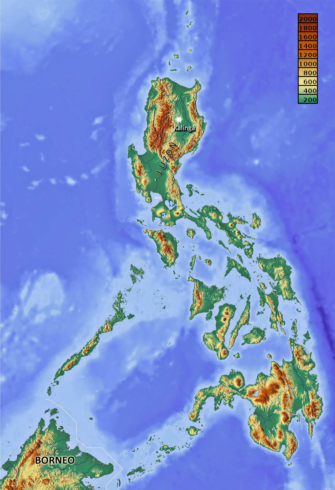
Topography of the Philippines, showing location of the Kalinga site. Palest blue sea would have been above sea level during glacial maxima. At such times Borneo would have been part of Sundaland – linked to mainland Asia (credit: Wikipedia)

A large team, with members from France, Philippines, Australia, Spain, Germany, Holland, Spain and Greece, has been excavating a tool- and fossil-rich site in thick alluvium at Kalinga in northern Luzon since 2014 (Ingicco, T. and 22 others 2018. Earliest known hominin activity in the Philippines by 709 thousand years ago. Nature, published online). It occurs in an erosional channel filled with mud. Stone artefacts comprise 56 flakes, hammer stone and cores, the tools being crude – a common feature of the Asian H. erectus lithic culture, unlike that in Africa and Europe. As well as fragments of other animals, the site is notable for a 75% complete, but disarticulated, skeleton of a rhinoceros scattered over a small area. That in itself suggests that the beast may have been butchered, and is confirmed by cut marks and signs of smashing on several of the bones. Uranium-thorium dating of one of the animal’s teeth (709±68 ka) and sediment grains from above and below the fossiliferous unit by electron-spin resonance (701±70 and 727±30 ka respectively) confirms the great antiquity of the site. Dating of volcanic plagioclase crystals from sediments by the 40Ar/39Ar method yields even older dates around 1 Ma, but the crystals may have been washed for older volcanic ash deposits.

It seems beyond doubt that early hominins, possibly H. erectus, colonised Luzon some 700 ka ago, yet, according to the authors, ‘it still seems too farfetched to suggest that H. erectus, or another unknown Pleistocene ancestral candidate … were able to construct some sort of simple watercraft and deliberately cross sea barriers’. That seems to be pushing caution a little too far. Do the authors not believe their own – to me compelling – evidence and analyses? But the paper spent a year in review, so maybe they came up against a singularly pernickety referee (three are named but one remains anonymous). Presumably, if a hominin fossil turns up during on-going excavations, that would change everything apart from the question, ‘Did they walk, swim or navigate?’ Luzon and the Philippines archipelago as a whole are surrounded by sea shallow enough for them to have been a single landmass during a glacial maximum when sea level was around 100 m lower than at present. At such a juncture a less than 20 km sea journey would have separated the Philippines from Borneo, then part of a vast area of lowland to the SW (Sundaland) that was connected to the Asian mainland.

A fully revised edition of Steve Drury’s book Stepping Stones: The Making of Our Home World can now be downloaded as a free eBook

Mystery of upside-down dinosaurs resolved

Remains of ankylosaurs, a popular family of heavily armoured dinosaurs, occur in sedimentary sequences that range in age from early Jurassic to the close of the Cretaceous. Their defences seem almost impregnable, being constructed of thick, fused scales, often bearing formidable spines, which covered them completely. They bore a crude resemblance to modern armadillos apart from the fact that they were unable to roll-up defensively. In some species the rigid tail bears a large, knob of scale tissue. At up to 3 m long, were the tail to be swung it would have packed bone-cracking momentum. Interestingly, to a poorly sighted predator the club may have been mistaken for the animal’s head at the end of a long neck, so perhaps it lured a potential assailant within range of its devastating power. The largest ankylosaur, from the Cretaceous of western Canada, was the size of a small bus, up to 8m long, 1.5 m wide, standing 1.7 m high and weighing in at around 5 to 8 t. Such dimensions would have made it almost impossible to be bitten, even by the largest predatory dinosaurs, and difficult to turn over. Their teeth show that ankylosaurs were herbivorous, and their somewhat bulbous bodies almost certainly contained a massive digestion system.

Polski: JuraPark Bałtów - Park Dinozaurów - An...
Recfonstruction of Ankylosaurus at the JuraPark Bałtówin Poland (credit: Wikipedia)

The mystery lies in the fact that most ankylosaur fossils are found lying on their backs. Early dinosaur aficionados suggested a tendency for the lumbering beasts to tumble down slopes and become stranded on their backs, so to die miserably. Such clumsiness is hardly a positive characteristic of evolutionary fitness for such a long-lived group, and, besides, the sedimentary formations in which they are found indicate very gentle slopes. So, were they flipped by dextrous predators, as imagined in some early films purporting to look to the distant past? Probably not, for most well preserved fossils show no sign of bites or gnawing. From a study of 36 late-Cretaceous ankylosaurs from Alberta four Canadian and US palaeontologists (Mallon, J.C. et al. 2018. A “bloat-and-float” taphonomic model best explains the upside-down preservation of ankylosaurs. Palaeogeography, Palaeoclimatology, Palaeoecology, v. 497, p. 117-127; doi:10.1016/j.palaeo.2018.02.010 support the idea of their carcases or even living animals having been picked up by flood waters when their high centre of gravity would have flipped them upside down. Bloating through decay might then allow them to be transported large distances. Unsurprisingly, their conclusions rest on model simulations.

How rich are deep-sea resources?

My first task as a Lecturer in Earth Sciences at the British Open University, from 1971 onward, was to write teaching materials about the economics, formation and geological setting of metal resources. Much of the content was about the full range of ‘conventional’ metal ores, but something being publicised as having huge potential intrigued me. This concerned manganese-rich nodules (with the aesthetic appeal of unwashed potatoes) and crusts found sitting on top of sediments of the abyssal ocean floor, at depths between 3 to 5 kilometres.  While manganese is by no means a rare element and occurs in vast ore reserves on the continents, the nodules contain unusually high concentrations of other, more valuable metals, such as copper, nickel, zinc, cobalt and lead. Some contained more than 3% of Cu, Ni and Co combined, above the ‘grades’ of economic deposits of ores of the individual metals on land. This was the source of their potential: simple, albeit very deep dredging of the nodules would provide multi-metal ore of very high profitability. Moreover, the nodules are in truly vast tonnages (about 10 kg m-2) and continually grow by precipitation from seawater in the underlying sediments at a few millimetres per million years – they are renewable resources.

Manganese nodules taken from the bottom of the...
Manganese nodules from the Pacific abyssal plains. (credit: Wikipedia)

A variety of reasons, not the least of which was the vexatious question of ownership of sea-floor resources far from land, have meant that commercial operations have yet to begin. However, spiralling prices for metals on the world market together with depletion of on-shore, high-grade reserves are beginning to make the opportunity of nodule mining irresistible. Fifteen companies, with licence areas issued by the intergovernmental  International Seabed Authority of around 75 000 km2 each, are now engaged in economic assessment of one of the most remote swathes of the Pacific abyssal plains (Peacock, T. & Alford M.H. 2018. Is deep-sea mining worth it? Scientific American, v. 318(5) (May 2018 issue), p. 63-67). There are several controversial issues surrounding deep-sea mining. First, dredging, like beam trawling disturbs and destroys ocean-floor ecosystems and turns bottom water turbid, the very fine grain size of sediments resulting in settling being very slow ( about 1 mm s-1). Second, preliminary ore processing on board dredging vessels results in plumes of turbid and metal-rich slurry in the wakes, threatening surface and mid-water ecosystems. Such plumes will rapidly spread far from operational areas in surface current systems, eventually to smother pristine areas of ocean floor. Re-examination of areas of experimental dredging from 30 years ago have revealed that they are still sterile of lifeforms larger than 50 micrometres. Added to these effects, onshore processing will produce large amounts of waste – about 75% of the volume of dredged nodules. Conventional mines eventually backfill their excavations, but with nodule mining disposal would be an environmental nightmare.

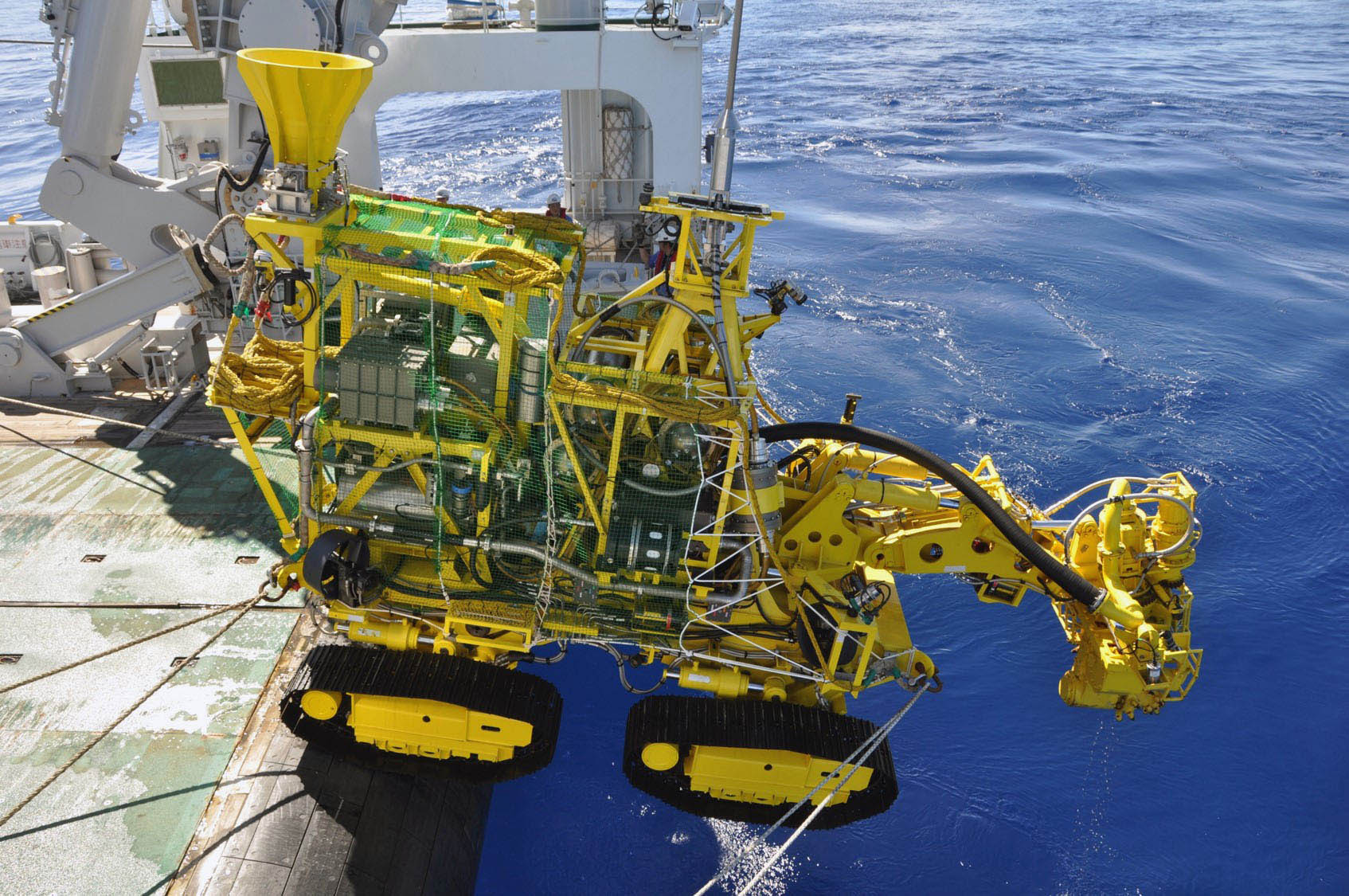
Japanese sea-floor mining machine. (credit: Japan Times)

Economically, it seems that nodule dredging is potentially highly profitable. To break even requires lifting about a million metric tons, which would yield of the order of 37 000 t of Ni, 32 000 t of Cu, 6000 t of Co and 750 000 t manganese. If all 15 companies begin extraction, production at these levels will have a downward effect on world metal prices, tending to undercut production from conventional mines. One little-considered issue is that the ‘blend’ of metals from nodules will not match the industrial demand for each of them, further destabilising markets. Added to mining of the abyssal plains, plans are well advanced for multi-metal mining of massive sulfide deposits forming at hydrothermal vents or ‘black smokers’ along mid-ocean ridge systems, in which gold figures strongly. Only a few Pacific island states have resisted the ‘promise’ of such operations. Japanese companies are already mining the seabed off Okinawa within their own offshore waters and seemingly are producing zinc equivalent to the country’s annual consumption as well as gold, copper and lead.

When dinosaurs roamed the Western Isles

Cuillin Hills, Isle of Skye, Scotland, UK
Cuillin Hills, Isle of Skye, Scotland, UK (credit: Wikipedia)

The Isle of Skye off the northwest coast of Scotland  is known largely as a prime tourist destination, such as Dunvegan Castle with a real clan chief (The MacLeod of MacLeod) and its Faerie Flag; Britain’s only truly challenging mountains of the Black Cuillin; and, of course, the romantic connection with the Young Pretender, Charles Edward Stuart and his escape, in drag, from the clutches of the Duke ‘Butcher’ Cumberland, hence the Skye Boat Song. Geologists know it best for its flood basalts with classic stepped topography and the exhumed guts of a massive central volcano (the Cuillin), relics of the Palaeocene-Eocene (62 to 54 Ma) North Atlantic Large Igneous Province. The spectacular Loch Coruisk, a glacial corrie drowned by the sea, exposes the deepest part of the main magma chamber. It is also the lair of Scotland’s lesser known Monster, the dread Each Uisge (Water Horse). Yet evidence is emerging for the former presence in the Hebrides of other, more tangible monsters.

Skye’s great volcanic edifice rests on Mesozoic sedimentary rocks including shallow-water muddy limestones of the Great Estuarine Group of Middle Jurassic (Bathonian, 174–164 Ma) age. For dinosaur specialists this is of the time when meat-eating theropods and herbivorous sauropods began growing to colossal sizes. Yet the Bathonian is notable for its global paucity in well exposed terrestrial and near-shore sedimentary sequences. Easily accessible, the Skye Bathonian sequence is much visited and has yielded a rich, though generally fragmentary fauna. A group of recent visiting palaeontologists from the University of Edinburgh, the Chinese Academy of Sciences and Skye’s Staffin Museum have discovered an extensive tract of wave-cut platform on the east shore of the Trotternish Peninsula where lagoonal carbonate muds were trampled by several dinosaurs that left around 50 tracks (dePolo, P.E. et al. 2018. A sauropod-dominated tracksite from Rubha nam Brathairean (Brothers’ Point), Isle of Skye, Scotland. Scottish Journal of Geology, online; doi:10.1144/sjg2017-016).

Dinosaur foot prints from Skye. Left example of a sauropod rear-foot print; right theropod. (credit dePolo, P.E. et al. 2018, modified from Figs 8 and 9a)

Some are of medium-sized sauropods (either Parabrontopodus or Breviparopus – both names for footprints rather than any genus of dinosaur) whose crudely elephant-like footprints are up to 0.5 m across (the largest, from Western Australia, are about 1.7 m across). Although there are fragmentary dinosaur bones from the same strata, assigning the footprint to a known species is not possible. However, foot size can be used to estimate how high the creatures’ hips stood (2 to 2.5 m): hefty beasts but not the true giants of later times A variety of three-toed, clawed, somewhat bird-like, footprints also occur. They are assigned to probably bipedal carnivores or theropods. Variation in foot size suggests a range of hip-height from about 0.9 to 2 metres, so these carnivores would have been pretty formidable.

A fully revised edition of Steve Drury’s book Stepping Stones: The Making of Our Home World can now be downloaded as a free eBook
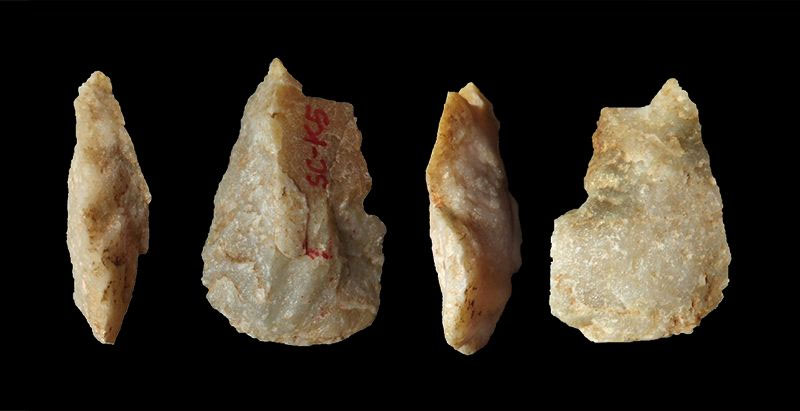
Volcano heading for the sea

John Murray of The Open University, UK has been studying Europe’s largest active volcano Mount Etna on Sicily for most of his career. With a group of colleagues he installed high-precision GPS receivers at over 100 stations on the flanks of the mountain. This was to monitor any shifts in elevation and geographic position, which might be related to magmatic events within the volcano, such as inflation and contraction of the magma chamber. Measurements of position gathered annually since 2001 reveal a somewhat alarming picture (Murray, J.B. et al. 2018. Gravitational sliding of the Mt. Etna massif along a sloping basement. Bulletin of Volcanology, v. 80 online, open access; doi /10.1007/s00445-018-1209-1). The edifice is moving relentlessly ESE at 14 mm yr-1, on average, towards the Mediterranean Sea. Research by one of Murray’s co-authors, Benjamin van Wyk de Vries of the Université Clermont Auvergne, established that many volcanoes have associated signs of deformation due to their huge masses. Often, this is a matter of radial spreading that produces thrust-like faults at their base and in the basement on which they grew. In the case of Etna all the annual displacements on its flanks are skewed to the ESE. The researchers are able to show that this is not a case of flank instability that ultimately may result in lateral collapse but the entire volcano is slowly slipping sideways.

English: Mount Etna, Sicily, topped in snow It...
Mount Etna, Sicily, topped in snow (credit: Wikipedia)

An experimental mock up of the volcano– a cone and flanking layers of lava and pyroclastic rocks made of sand on a substrate of putty to represent underlying sedimentary strata – began to slide once it was tilted at a shallow angle. This suggests that the base of the volcano and igneous debris that it has emitted dips gently to the ESE. The underlying materials are poorly consolidated Quaternary sediments, which are likely to be rheologically weak. Geophysics shows that the NW side of the volcano rests on an almost horizontal plateau, the cone itself being above a spoon-like depression, probably produced by the cone’s mass, and the base dips seawards  in the SE sector. It is through this basement that magma makes its way to Etna’s summit vent system, probably along fractures.

The authors warn that such sliding volcanoes are prone to devastating sector collapse on the downslope side, although there are no signs that might be imminent. Yet it will almost certainly have an effect on eruptive activity as the magma conduits are continually changing. Future research needs to focus on periods when there is horizontal contraction on the volcano, as happens during lengthy periods of dormancy – the period for which there are data has been one of expansion.

Human evolution and revolution in Africa

Toba eruption: a hindrance or a spur to humans?

English: Erosional dissection of an ash deposi...
Ash-fall blanket at Mount Pinatubo volcano in the Philippines. (credit: Wikipedia)

The eruption that created the 100 by 30 km Toba caldera 74 ka ago was the largest recorded volcanic event during the two million years of the genus Homo’s evolution. It ejected an estimated 800 cubic kilometres of ash to blanket the land surface thousands of kilometres away. By analogy with the known effects of stratospheric ash and sulfate aerosols from  the much smaller 1991 eruption of the Mount Pinatubo in the Philippines, which  reduced mean global temperature by 0.5 °C, Toba might be expected to have had an even larger cooling effect, perhaps by as much as 10° C. Such a scenario has led palaeoanthropologists to suggest that there would have been major effects on humans migrating across Eurasia at the time, such as dramatic population reduction and maybe a genetic ‘bottleneck’ that could have led to rapid evolution among surviving generations. Yet, not only are stone tools found below the Toba Ash in Sumatra, but also in South India and immediately above it too. Yet analysis of Toba’s environmental effects recorded by sediments on the bed of Lake Malawi in southern African reveal little if any sign of a global ‘volcanic winter’.

A letter in Nature, published online on 15 March 2018 (Smith, E.J. and 15 others 2018. Humans thrived in South Africa through the Toba eruption about 74,000 years ago. Nature, v. 555; doi:10.1038/nature25967) decisively refutes any retardation of human cultural progress, in southern Africa at least, and suggests the opposite. Smith and colleagues from South Africa, Australia and the US found ash dated at around 74 ka 9,000 km away from Toba in sedimentary sequences that contain anatomically modern human remains and artefacts at the coastal Vleesbaai and Pinnacle Point sites in Cape Province South Africa. To check on the likelihood of a fortuitous coincidence of another eruption having shed the ash, the team compared detailed geochemical analyses of ash samples with those from other volcanoes and bona fide Toba samples, with a clear confirmation of provenance. In the archaeological record, rather than any sign of a cultural setback, the intensity of use of the sites increased after the ash-fall event, accompanied by significant technological innovations. Perhaps the Pinnacle Point community was lucky and also responded in the spirit of the adage ‘necessity is the mother of invention’. Discovery of the Toba ash at other ancient human sites would resolve the issue.

Hominin cultural revolution 320,000 years ago

As regards stone tools, the Olorgesailie Basin in southern Kenya is about as good as it gets; a long-used ‘factory’ that covers a time span from about 1. 2 to 0.03 Ma. In places, large areas of the surface underlain by sedimentary strata, some of which have become major tourist attractions, are liberally strewn with tools and debitage from their manufacture. The area is ideal for stone-tool makers: being within the East African Rift it contains outcrops of many hard, fine-grained volcanic rocks and cherts formed by hot springs interleaved with its dominant fill of lake and riverine sediments. There are two dominant sedimentary units: the Olorgesailie Formation (1.2 to 0.49 Ma) overlain by the Oltulelei  Formation (0.32 to 0.05 Ma), the time gap between the two marking an extended period of regional erosion. Despite the rich tool assemblages, hominin remains have yet to be unearthed from the sediments, although there are plenty of bones from potential prey mammals. Olorgesailie was  good place to live, especially as the Rift would have channelled migrating herds predictably between its steep-sided flanks.

Acheulean biface tools strewn on a bedding surface in the Olorgesailie Basin, Kenya (credit: mmercedes_78 https://www.flickr.com/photos/27325832@N06/3833105587)

The older formation has yielded biface tools of the Acheulean technology from bottom to top. The earliest Acheulean tools in Africa date back to about 1.7 Ma and have been attributed to Homo ergaster/erectus, although examples in Europe are associated with H. antecessor and H. heidelbergensis – the technology was active for about 1.4 Ma. The Acheulean method involved striking flakes from large blocks of rock to result in a symmetrical, pear-shaped core that served as a multipurpose tool.   The oldest strata in the Oltulelei  Formation contain exclusively tools that are very different , having been made by a significantly more complicated procedure and covering a wide variety of designs with different uses. This Levallois technique focused on thin flakes produced from cores after careful preparation, which enabled similar tools to be made repeatedly rather than relying on chance fracturing. Precise dating of the oldest of these assemblages gives an age of 320 ka (Deino, A.L. et al. 2018. Chronology of the Acheulean to Middle Stone Age* transition in eastern Africa. Science, v. 359 online; DOI: 10.1126/science.aao2216). The makers clearly were able to visualize the finished product within the original lump of raw stone, but in a more nuanced way than did the makers of Acheulean biface tools. The first-described Levallois tools were associated with European Neanderthals.

English: Levallois flake obtained by the prefe...
Producing a flake by the Levallois technique (credit: Wikipedia)

Sometime in the 500 to 320 ka interval removed by erosion a major shift in technology and almost certainly cognition took place. Not only was this a technological revolution, but the Levallois tools are found in association with a variety of pigments, such as ochres, which show signs of having been worked, presumably for decoration of some kind. Also, the tool makers seemed to have a clear preference for specific rocks – black, glassy obsidian and cherts of white and green hues from sources 25 to 90 km from the tool-making sites (Brooks, A.S. and 14 others 2018. Long-distance stone transport and pigment use in the earliest Middle Stone Age. Science, v. 359 online; DOI: 10.1126/science.aao2646). The sheer volume of tools at each site and the evidence for long-distance transport of the raw materials have prompted the authors to hazard a guess at some kind of trade, or at least cooperative intergroup interaction. Together with the use of pigment, probably for body ornamentation, this suggests individual and perhaps group identity within a kind of social network.

Of course, the big question is: Who made the leap? That’s a hard one in the absence of human remains associated with the tool-making factories at Olorgesailie . The authors of both papers argue for the earliest modern humans. But, to me, this seems like an assumption based on the age of the transition rather than any convincing evidence. The original Levallois tools from northern France were found in association with skeletal remains of Neanderthals but much later in the Pleistocene. An age of 320 ka does place the Olorgesailie tools in the same ballpark as early AMH fossils from Morocco, later than the genetically derived date of separation of Neanderthals and AMH. However, the 180 ka time gap in which the technological revolution took place gives some room for so-called African ‘archaic modern humans’ (not subdivided as are similar fossils from Europe) are known from Zimbabwe, Tanzania and Ethiopia. If the Neanderthals were using the Levallois technique in Europe there is every reason to suspect that they, or their possible forebears H. heidelbergensis, may have brought it with them from Africa.

The Olorgesailie tools figure in a third paper in the same volume of Science, but one with less shaky grounds (Potts, R. and 14 others 2018. Environmental dynamics during the onset of the Middle Stone Age in eastern Africa. Science, v. 359 online; DOI: 10.1126/science.aao2200). The wet-dry cycle of the Pleistocene, related to global warming and cooling in interglacial and glacial episodes respectively, had become more marked after the 500 to 320 ka period of tectonically induced erosion. In itself, this would have resulted in more marked shifts in the ecosystems of the basin – perhaps a case of necessity being the mother of invention. Yet, the evidence base for changing climate cycles in Africa is not from local lake-sediment stratigraphy, micropalaeontology or geochemistry, but from the modelled variation of insolation based on Milankovich’s hypothesis.

*Note:  The Middle Stone Age in Africa does not correlate with the Mesolithic of Europe, but is a legacy of the development of archaeology in Africa. It corresponds to the European Middle Palaeolithic.

See also:  Gibbons, A. Complex behaviour arose at dawn of humans. Science, v. 359, p. 1201-1202 (with video)

Sophisticated Neanderthal art now established

Note: Earth-Pages will be closing as of early July, but will continue in another form at Earth-logs

The first detailed description and analysis of the amazing cave paintings of Western Europe that have been attributed to anatomically modern humans (AMH) were made in the early 20th century by the Jesuit priest Abbé Henri Breuil. As well as that those of Lascaux and Altamira, which have been dated, many works in Spanish caves have not. Art ascribed to AMH includes figurative work depicting a wide range of Late Pleistocene animals, abstract and perhaps symbolic designs, and ‘signatures’ of individual people in the form of direct prints or stencils of hands. The earliest known graphic work made by modern humans is a 100 ka-old baton of ochre with a zig-zag set of sharp incisions found with ochre-filled shells possibly for body painting at Blombos Cave in South Africa.

Evidence for pre-AMH work in Europe is sparse and widely  judged to be ambiguous; for instance 50 ka-old ochre-stained and pierced shells associated with Neanderthal remains in Spain.  Hints at even earlier origins for art lie in the geometrically etched bivalve shells excavated by Eugene Dubois at the site in Java where he discovered Homo erectus crania in 1891. They have recently been dated at around half a million years old.  Occasionally, radiometric dating of drawings has revealed quite meagre red dots that are slightly older than the widely accepted date of first entry of AMH into Europe (~40-45 ka) and may have been made by Neanderthals. Of course, there are many European cave paintings associated with dates earlier than the extinction of Neanderthals (around 30 ka) that may have been made by them, but which are generally ascribed to AMH by assuming that only our species has the wit to make them.  Even the sophisticated Châtelperronian stone tools and rough ornaments associated with undeniable Neanderthal remains are considered by many paleoanthropologists to show skills copied from AMH.

This AMH-centric view of art depends on two outlooks: simple prejudice that any beings markedly different in appearance from us were intellectually inferior – generally condemned as racist if applied to different groups of living humans; lack of incontrovertible and unambiguous evidence to the contrary. Both are set to be rigorously challenged by the growing use of sophisticated radiometric U-Th dating of the thin films of chemically precipitated calcite (flowstone or speleothem) that often coat the walls of caves and are at least as old as the art that they cover. A German-Spanish-British team has applied the technique to artwork and painted stalactites on the walls of three caves in Spain known to have been occupied by hominins over the last 100 ka (Hoffmann, D.L and 13 others 2018. U-Th dating of carbonate crusts reveals Neandertal origin of Iberian cave art. Science, v. 359, p. 912-915; doi: 10.1126/science.aap7778. See also: Appenzeller, T. 2018. Europe’s first artists were Neandertals. Science, v. 359, p.852-853; doi: 10.1126/science.359.6378.852). One cave that was analysed is that at La Pasiega in Cantabria whose art was sketched by Abbé Breuil. The team’s results are dramatic: all the dated samples pre-date 40 Ka, the oldest at 79.66±14.90 ka being from La Pasiega. Precisely dated art includes hand stencils, painted stalactites, geometric patterns and line drawings of animals. Many of the caves’ artworks remain to be dated, including some well-executed animals and strange, possibly symbolic designs.

Symbolic Neanderthal art in La Pasiega cave, Spain – left: recent photograph; right: sketch produced Abbé Breuil in 1913. The red, ladder-like symbol has a minimum age of 64 ka but it is unclear if the animals and other symbols were painted later. (credit: Hoffmann et al. 2018, Supplementary Data Figure S4)

The implications of this work are far-reaching. Handprints and stencils are common throughout the archives of European cave art and seem generally to be the oldest at each site. The dating method is yet to applied to the bulk of cave art, much of which is encased in speleothem, so it is quite possible that ‘dual authorship’ may be discovered in some caves. It now seems clear that Neanderthals invented permanent art independently of AMH, and since art is a form of communication that has implications for the ability to speak as well as to think ‘outside-the-box’. The 177 ka corral-like enclosures made of stalactites and associated hearths deep within Bruniquel Cave seem more likely to have ritual significance, far from the light of day, for the Neanderthals that made them. The finds throw doubt on the implausibility of Neanderthal invention of so-called ‘transitional’ technologies, such as the Châtelperronian. Finally, fully modern humans in Africa and Neanderthals in Europe were doing much the same things over roughly the same time period; genetically and physically they parted company about 450 to 400 ka ago; both were capable of artistic symbolism and fulfilled that potential. That implies that their common ancestor may have passed on the proclivity, as might their predecessor H. erectus who created the etched mollusc shells of Trinil half a million years ago.

More on Neanderthals, Denisovans and AMH genetic relatedness

Editorial from the Guardian Newspaper 26 February 2018.

Impact debris in Britain

These days reports of geological evidence for asteroid impacts are not regarded with a mixture of disbelief, wonder and foreboding: well, not by geologists anyway. But for such a small area as Britain now to have three of widely different ages and in easily accessible places is pretty good for its brand as the place to visit for practically every aspect of Earth history. The first to be discovered lies at the base of Triassic mudstones near Bristol (see Britain’s own impact) and would need some serious grubbing around at a former construction site. The next to emerge was located in one of the best geological districts in the country at several easily accessed coastal exposures in Northwest Scotland. A glass-rich ejecta layer occurs in the basal Torridonian Stoer Group on Stac Fada, Stoer, Sutherland (UK National Grid Reference 203300, 928400). The most recently found (Drake, S.N. and 8 others 2018. Discovery of a meteoritic ejecta layer containing unmelted impactor fragments at the base of Paleocene lavas, Isle of Skye, Scotland. Geology, v. 46, p. 171-174; doi:10.1130/G39452.1) is on the Inner Hebridean island of Skye at the base of its famous Palaeocene flood basalt sequence (UK National Grid Reference 155371,821112).

View to the northwest across Loch Slapin to the Cuillin Hills of Skye (Central Igneous Complex). The flood basalts beneath which the ejecta layer occurs are just above the trees. (Credit: Wikipedia)

The last is perhaps the most spectacular of the three, as it contains the full gamut of provenance, matched only by material from the drill core into the 66 million year-old Chicxulub crater. The 0.9 m thick debris layer rests directly on mid-Jurassic sandstones beneath Palaeocene basalts of the North Atlantic Igneous Province (NAIP). The layer contains a basalt clast dated at 61.54 Ma, but is dominantly reminiscent of a pyroclastic ignimbrite flow as it contains glass shards. But there the resemblance ends for the bulk of small clasts are of quartz and K-feldspar, sandstone and gneiss. Zircons extracted from the debris show shock lamellae and give Archaean and Proterozoic ages commensurate with the local basement, but also with the bulk of the Scandinavian and Canadian Shields. So the impact could have been anywhere in such widespread terrains, although the enclosed basalt narrows this down to areas where basement is overlain by lavas of the NAIP. The Skye impactite contains unmelted meteorite fragments in the form of titanium nitrides alloyed with vanadium and niobium, metallic iron-silicon alloy containing exsolved carbon, and manganese sulfide.

Although it may be coincidental, the situation of the ejecta layer immediately beneath the Skye lavas, its containing a clast of basalt whose age corresponds to the oldest flows anywhere in the NAIP is fascinating. But the actual impact site is, as yet, unknown. Even so, the layer provokes thoughts about whether an impact may have been more than spatially related to the large NAIP flood basalt pile, preserved on either side of the North Atlantic. If the event was large, then surely the ejecta should be preserved near the base of the flood basalts elsewhere in NW Britain and further afield

Hadean potentially fertile for life

The earliest incontrovertible signs of life on Earth are in the 3.48 billion-year-old Dresser Formation in the Pilbara craton of Western Australia, which take the form of carbon-coated, bubble-like structures in fine-grained silica sediments ascribed to a terrestrial hot-spring environment. In the same Formation are stromatolites that are knobbly, finely banded structures made of carbonates. By analogy with similar structures being produced today by bacterial mats in a variety of chemically stressed environments that are inhospitable for multicelled organisms that might know them away, stromatolites are taken to signify thriving, carbonate secreting bacteria. There are also streaks of carbon associated with wave ripples that may have been other types of biofilm. A less certain record of the presence of life are stromatolite-like features in metasediments from the Isua supracrustal belt of West Greenland, dated at around 3.8 Ga, which also contain graphite with carbon-isotopic signs that it formed from biogenic carbon. Purely geochemical evidence that carbonaceous compounds may have formed in living systems are ambiguous since quite complex hydrocarbons can be synthesised abiogenically by Fischer-Tropsch reactions between carbon monoxide and hydrogen.

At present there is little chance of extending life’s record further back in time than four billion years because the Hadean is mainly represented by pre 4 Ga ages of zircon grains found in much younger sedimentary rocks – resistant relics of Hadean crustal erosion. The eastern shore of Hudson Bay does preserve a tiny (20 km2) patch of metamorphosed basaltic igneous rocks, known as the Nuvvuagittuq Greenstone Belt. Dated at 3.77 Ga by one method but 4.28 Ga by another, this could be Hadean. Like the Isua sequence that in Quebec also contains metasediments, including banded ironstones with associated iron-rich hydrothermal deposits. Silica from the vent system shows dramatically lifelike tubules. Yet the ambiguity in dating upsets any claims to genuine Hadean life. There has also been a physical stumbling block to the notion that life may have originated and thrived during the Hadean: the bombardment record.

English: An outcrop of metamorphosed volcanose...
Metamorphosed volcanosedimentary rocks from the Nuvvuagittuq supracrustal belt, Canada. Some of these rocks contain quite convincing examples of fossil cells. (credit: Wikipedia)

While oxygen-isotope data from 4.4 Ga zircons hints strongly at subsurface and perhaps surface water on Earth at that time, continued accretion of large planetesimals would have created the hellish conditions associated with the name of the first Eon in Earth’s history. Liquid water is essential for life to have formed, on top of a supply of the essential biological elements C, H, O, N, P and S. The sheer amount of interstellar dust that accompanied the Hadean impact record would have ensured fertile chemical conditions, but would the surface and near-surface of the early Earth have remained continually wet? Judging by the lunar surface and that of other bodies in the solar system, after the cataclysmic events that formed the Moon, many Hadean impacts on Earth were in the range of 100 to 1000 km across, with a Late Heavy Bombardment (LHB)that not only increased the intensity of projectile delivery but witnessed the most energetic single events such as those that created the lunar maria and probably far larger structures on Earth. The thermal energy, accompanied, by incandescent silicate vapour ejected from craters, may have evaporated oceans and even subsurface water with calamitous consequences for early life or prebiotic chemistry. Until 2017 no researchers had been able to model the energetic of the Hadean convincingly.

After assessing the projectile flux up to and through the LHB, and the consequent impact heating Bob Grimm and Simone Marchi of the Southwest Research Institute in Boulder, Colorado modelled the likely thermal evolution of the outer Earth through the Hadean. This allowed them to calculate the likely thermal gradients in the near-surface, the volumes of rock each event would have affected and the times taken for cooling after impacts (Grimm, R.E. & Marchi, S. 2018. Direct thermal effects of the Hadean bombardment did not limit early subsurface habitability. Earth and Planetary Science Letters, v. 485, p. 1-9; doi:10.1016/j.epsl.2017.12.043). They found that subsurface ‘habitability’ would have grown continuously throughout the Hadean, even during the worst events of the LHB. Sterilizing Earth and thus destroying and interrupting any life processes could only have been achieved by ten times more projectiles arriving ten times more frequently over the 600 Ma history of the Hadean and LHB. Although surface water may have been evaporated by impact-flash heating and vaporized silicate ejecta, the subsurface would have been wet at least somewhere on the early Earth. Provided it either originated in or colonised surface sedimentary cover it would have been feasible for life to have survived the Hadean. However, nobody knows how long it would have taken for the necessary accumulation of prebiotic chemicals and to achieve the complex sequence of processes that lead to nucleic acids encapsulated in cells and thus self-replication and life itself.

Earliest departure of modern humans from Africa

In June 2017 the likely age of the earliest anatomically modern humans (AMH) was pushed back to almost 300 ka with the dating of their remains found at Jebel Irhoud in Morocco. It seemed only a matter of time before their first departure from Africa would also be shown to be earlier than generally believed at between 90 to 120 ka measured from AMH remains in the Skhul and Qafzeh caves of Israel. Such an exodus may be reflected by dates (80 to 113 ka) from fragmentary and indeterminate human remains in China, but a more definite, far-travelled AMH presence in east Asia is, so far, limited to about 60 ka. Yet there is genetic evidence from Neanderthal DNA from Germany and Siberia for human-Neanderthal interbreeding at some time between 219 and 460 thousand years before present: a very hazy intimation but one that needs accounting for. The main phase of genetic introgression from Neanderthals into Homo sapiens has been estimated to have occurred at between 50 to 60 ka; more easily explained by the known AMH peregrination into Asia in that period.

Misliya Cave on Mount Carmel, Israel has now added to the Levantine AMH record. A partial upper jaw and some teeth provide morphological data that fall within the range of H. sapiens fossils, along with tools ascribed to the Levallois technology. This involved striking flakes from a prepared core – a tortoise-like bulge on the flake that detaches when struck properly to form a pre-sharpened flake, flat on one side and rounded on the other. This method was shared by both AMH and Neanderthals, and examples of the tools extend as far back as 500 ka in Africa and may have been invented by a common ancestor of both human groups. Levallois tools were found with the AMH fossils at Jebel Irhoud and also in the Levant at Tabun, dated at 190 to 260 ka, but with no associated fossil remains of their makers. Those at Mislya Cave yielded a mean age from the use of three different dating methods at least 177 ka ago, making the fossil jaw found with them the earliest direct sign of AMH outside Africa (Hershkovitz, I. and 34 others 2018. The earliest modern humans outside Africa. Science, v. 359, p. 456-459; doi: 10.1126/science.aap8369).

So, Mislya supports the genetic evidence of human-Neanderthal Introgression in Eurasia (see; Stringer, C & Galway-Witham, J. 2018. When did modern humans leave Africa? Science, v. 359, p. 389-390; doi: 10.1126/science.aas8954) and provides a spur to extend work in China and between Arabia and eastern Asia. For decades the anatomically modern human remains in the Levant have been sidelined, that near-Mediterranean area being widely regarded as a ‘boulevard of broken dreams’. That is, until Levalloisian tools dated at up to 125 ka were found in the United Arab Emirates and Arabia as a whole had been shown to have had a monsoonal climate during the glacial period that preceded the last, Eemian interglacial and in several later episodes. Once in the Levant, and provided they continually had a foothold there, AMH had many windows of opportunity to move further east without having to await falls in sea-level to open routes such as that across the Red Sea via Straits of Bab el Mandab.