Evidence for an early Archaean transition to subduction

Modern plate tectonics is largely driven by slab-pull: a consequence of high-pressure, low-temperature metamorphism of the oceanic crust far from its origin at an oceanic ridge. As it ages, basaltic crust cools, become increasingly hydrated by hydrothermal circulation of seawater through it and its density increases. That is why the abyssal plains of the ocean floor are so deep relative to the shallower oceanic ridges where it formed. Due to the decrease in the Earth’s internal heat production by decay of radioactive isotopes, once oceanic lithosphere breaks and begins to descend high-P low-T metamorphism transforms the basaltic crust to a denser form: eclogite, in which the dense, anhydrous minerals garnet and sodium-rich pyroxene (omphacite) form. Depending on local heat flow, the entire oceanic slab may then exceed the density of the upper mantle to drag the plate downwards under gravity. Metamorphic reactions of any P-T regime creates minerals less capable of holding water and drive H2O-rich fluids upwards into the overriding lithosphere, thus inducing it to partially melt. Magmas produced by this create volcanism at the surface, either at oceanic island arcs or near to continental margins, depending on the initial position of the plate subduction.

A direct proof of active subduction in the geological record is the presence of eclogite and related blueschists. Such rocks are unknown before 2100 Ma ago (mid-Palaeoproterozoic of the Democratic Republic of Congo) but there are geochemical means of ‘sensing’ plate tectonic control over arc magmatism (See: So, when did plate tectonics start up? February 2016).  The relative proportions of rare-earth elements in ancient magmatic rocks that make up the bulk of continental crust once seemed to suggest that plate tectonics started at the end of the Archaean Eon (~2500 Ma). That method, however, was quite crude and has been superseded by looking in great detail at the geochemistry of the Earth’s most durable mineral: zircon (ZrSiO4), which began more than two decades ago. Minute grains of that mineral most famously have pushed back the geological record into what was long believed to be half a billion years with no suggestion of a history: the Hadean. Zircon grains extracted from a variety of ancient sediments have yielded U-Pb ages of their crystallisation from igneous magma that extend back 4.4 billion years (Ga) (see: Pushing back the “vestige of a beginning”;January 2001).  

Though simple in their basic chemical formula, zircons sponge-up a large range of other trace elements from their parent magma. So, in a sense, each tiny grain is a capsule of their geochemical environment at the time they crystallised. In 2020 Australian geochemists presented the trace-element geochemistry of 32 zircons extracted from a 3.3 Ga old sedimentary conglomerate in the Jack Hills of Western Australia, which lie within an ancient continental nucleus or craton. They concluded that those zircons mainly reveal that they formed in andesitic magmas, little different from the volcanic rocks that are erupted today above subduction zones. From those data it might seem that some form of plate tectonics has been present since shortly after the Earth’s formation. Oxygen-isotope data from zircons are useful in checking whether zircons had formed in magmas derived directly from partial melting of mantle rocks or by recycling of crustal magmatic rocks through subduction. Such a study in 2012 (see: Charting the growth of continental crust; March 2012) that used a very much larger number of detrital zircon grains from Australia, Eurasia, North America, and South America seemed, in retrospect, to contradict a subduction-since-the-start view of Earth dynamics and crust formation. Instead it suggested that recycling of crust, and thus plate-tectonic subduction, first showed itself in zircon geochemistry at about 3 Ga ago.

Detailed chemical and isotopic analysis of zircons using a variety of instruments has steadily become faster and cheaper. Actually finding the grains is much easier than doing interesting things with them. It is a matter of crushing the host rock to ‘liberate’ the grains. Sedimentary hosts that have not been strongly metamorphosed are much more tractable than igneous rocks. Being denser than quartz, the dominant sedimentary mineral, zircon can be separated from it along with other dense, trace minerals, and from them in turn by various methods based on magnetic and electrical properties. Zircons can then be picked out manually because of their distinctive colours and shapes. A tedious process, but there are now several thousand fully analysed zircons aged between 3.0 to 4.4 Ga, from eleven cratons that underpin Australia, North America, India, Greenland and southern Africa. The latest come from a sandstone bed laid down about 3.31 Ga ago in the Barberton area of South Africa (Drabon, N. et al. 2022. Destabilization of Long‐Lived Hadean Protocrust and the Onset of Pervasive Hydrous Melting at 3.8 GaAGU Advances, v. 3, article e2021AV000520; DOI: 10.1029/2021AV000520). The authors measured lutetium (Lu), hafnium (Hf) and oxygen isotopes, and concentrations of a suite of trace element in 329 zircons from Barberton dated between 3.3 to 4.15 Ga.
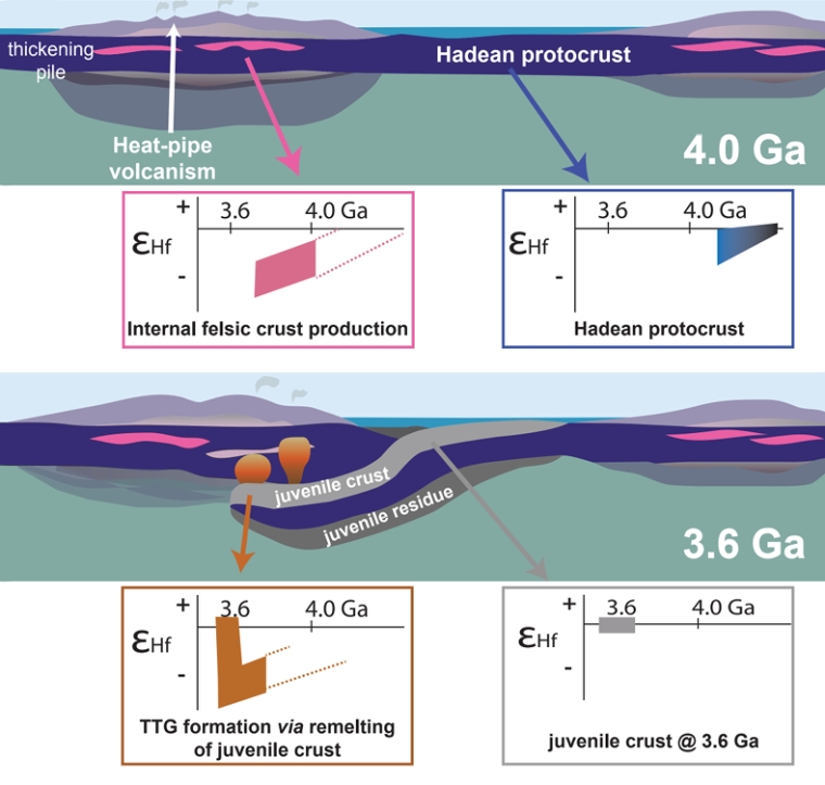
A schematic model of transition from Hadean-Eoarchaean lid tectonics to a type of plate tectonics that subsequently evolved to its current form, based on hafnium isotope data in ancient zircons (credit: Bauer et al. 2020; Fig 3)

The Hf isotopes show two main groups relative to the values for chondritic meteorites (assumed to reflect the composition of the bulk Earth). Zircons dated between 3.8 and 4.15 Ga all show values below that expected for the whole Earth. Those between 3.3 and 3.8 Ga show a broader range of values that extend above chondritic levels. The transition in data at around 3.8 Ga is also present in age plots of uranium relative to niobium and scandium relative to ytterbium, and to a lesser extent in the oxygen isotope data. On the basis of these data, something fundamentally changed in the way the Earth worked at around 3.8 Ga. Nadja Drabon and colleagues ascribe the chemical features of Hadean and Eoarchaean zircons to an early protocrust formed by melting of chemically undepleted mantle. This gradually built up and remained more or less stable for more than 600 Ma, without being substantially remelted through recycling back to mantle depths. After 3.8 billion years ago, geochemical signatures of the zircons start showing similarities to those of zircons derived from modern subduction zones. Hf isotopes and trace-element geochemistry in 3.6 to 3.8 Ga-old  detrital zircons from other cratons are consistent with a 200 Ma transition from ‘lid’ tectonics (see: Lid tectonics on Earth; December 2017) to the familiar tectonics of rigid plates whose basalt-capped lithosphere ultimately returns to the mantle to be involved in formation of new magmas from which continental crust stems. Parts of plates bolstered by this new, low density crust largely remain at the surface.

While Drabon et al. do provide new data from South Africa’s Kaapvaal craton, their conclusions are similar to earlier work by other geochemists based on data from other area (e.g. Bauer, A.M. et al. 2020. Hafnium isotopes in zircons document the gradual onset of mobile-lid tectonicsGeochemical Perspectives Letters, v. 14; DOI: 10.7185/geochemlet.2015), which the accompanying figure illustrates.

See also: Earliest geochemical evidence of plate tectonics found in 3.8-billion-year-old crystal. Science Daily, 21 April 2022. 3.8-Billion-Year-Old Zircons Offer Clues to When Earth’s Plate Tectonics Began. SciNews, 26 April 2022

Lower-mantle blobs may reveal relics of event going back to the Hadean

The World-Wide Standardised Seismograph Network (WWSSN) records the arrivals of waves generated by earthquakes that have passed through the Earth’s interior. There are two types of these body waves: S- or shear waves that move matter at right angles to their direction of movement; compressional or P-waves that are a little like sound waves as materials are compressed and expanded along the direction of movement. Like sound, P-waves can travel through solids, liquids and gases. Since liquids and gases are non-rigid they cannot sustain shearing, so S-waves only travel through the solid Earth’s mantle but not its liquid outer core. However, their speed is partly controlled by rock rigidity, which depends on the temperature of the mantle; the hotter the lower the mantle’s rigidity.

Analysis of the S-wave arrival times throughout the WWSSN from many individual earthquakes enables seismologists to make 3-D maps of how S-wave speeds vary throughout the mantle and, by proxy, the variation of mantle rigidity with depth. This is known as seismic tomography, which since the late 1990s has revolutionised our understanding of mantle plumes and subduction zones, and also the overall structure of the deep mantle. In particular, seismic tomography has revealed two huge, blob-like masses above the core-mantle boundary that show anomalously low S-wave speeds, one beneath the Pacific Ocean and another at about the antipode beneath Africa: by far the largest structures in the deep mantle. They are known as ‘large low-shear-wave-velocity provinces’ (LLSVPs) and until recently they have remained the enigmatic focus of much speculation around two broad hypotheses: ‘graveyards’ for plates subducted throughout Earth history; or remnants of the magma ocean thought to have formed when another protoplanet impacted with the early Earth to create the Moon about 4.4 billion years ago.

Three-dimensional rendition of seismic tomography results beneath Africa. Mantle with anomalously low S-wave speeds is show in red, orange and yellow. The faint grey overlay represents the extent of surface continental crust today – Horn of Africa at right and Cape Town at the lower margin – the blue areas near the top are oceanic crust on the floor od the Mediterranean Sea. (Image credit: Mingming Li/ASU)

Qian Yuan and Mingming Li of Arizone State University, USA have tried to improve understanding of the shapes of the two massive blobs (Yuan, Q. & Li, M. 2022. Instability of the African large low-shear-wave-velocity province due to its low intrinsic density. Nature Geoscience, v. 15  DOI: 10.1038/s41561-022-00908-3) using advanced geodynamic modelling of the seismic tomography. Their work reveasl that the Pacific LLSVP extends between 500 to 800 km above the core-mantle boundary. Yet that beneath Africa reaches almost 1000 km higher, at 1300 to 1500 km. Both of them are less rigid and therefore hotter than the surrounding mantle. In order to be stable they must be considerably denser than the rest of the mantle surrounding them. But, because it reaches much higher above the core, the African LLSVP is probably less dense than the Pacific one. A lower density suggests two things: the African blob may be less stable; the two blobs may have different compositions and origins.

Both the Pacific Ocean floor and the African continent are littered with volcanic rocks that formed above mantle plumes. The volcanic geochemistry above the two LLSVPs differs. African samples show signs of a source enriched by material from upper continental crust, whereas those from the Pacific do not. Yuan and Li suggest that the enrichment supports the ‘plate graveyard’ hypothesis for the African blob and a different history beneath the Pacific. The 3-D tomography beneath Africa (see above) shows great complexity, perhaps reflecting the less stable nature of the LLSVP. Interestingly, 80 % of the pipe-like African kimberlite intrusions that have brought diamonds up from mantle depths over that last 320 Ma formed above the blob.

But why are there just two such huge blobs of anomalous material that lie on opposite sides of the Earth rather than a continuous anomaly or lots of smaller ones? The subduction graveyard hypothesis is compatible with the last two distributions. In a 2021 conference presentation the authors suggest from computer simulations that the two blobs may have originated at the time of the Moon’s formation after a planetary collision (Yuan, Q. et al. 2021. Giant impact origin for the large low shear velocity provinces. Abstracts for the 52nd Lunar and Planetary Science Conference: Lunar and Planetary Institute, Houston). Specifically, they suggest that the LLSVPs originated from the mantle of the other planet (Theia) after its near complete destruction and melting, which sank without mixing through the magma ocean formed by the stupendous collision. Yet, so far, no geochemists have been bold enough to suggest that there are volcanic rocks of any age that reveal truly exotic compositions inherited from deep mantle material with such an origin. If Theia’s mantle was dense enough to settle through that of the Earth when both were molten, it would be sufficiently anomalous in its chemistry for signs to show up in any melts derived from it. There again, because of a high density it may never have risen in plumes to source any magma that reached the Earth’s surface …

Note added later: Simon Hamner’s Comment about alternative views on seismic tomography has prompted me to draw attention to something I wrote 19 years ago

Signs of massive hydrocarbon burning at the end of the Triassic

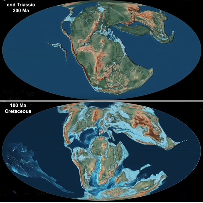
One of the ‘Big Five’ mass extinctions occurred at the end of the Triassic Period (~201 Ma), whose magnitude matches that of the more famous end-Cretaceous (K-Pg) event. It roughly coincided with the beginning of break-up of the Pangaea supercontinent that was accompanied by a major episode of volcanism preserved in the Central Atlantic Magmatic Province (CAMP). Eastern North America, West Africa and northern South America reveal scattered patches of CAMP flood basalts, swarms of dykes and large intrusive sills. Like all mass extinctions, that at the Triassic-Jurassic boundary left a huge selection of vacant or depleted ecological niches ready for evolution to fill by later adaptive radiation of surviving organisms. Because it coincided with continental break-up and drift, unlike other such events, evolution proceeded in different ways on the various wandering land masses and in newly formed seas (see  an excellent animation of the formation and break-up of Pangaea – move the slider to 3 minutes for the start of break-up). The Jurassic was a period of explosive evolution among all groups of organisms. The most notable changes were among marine cephalopods, to give rise to a bewildering variety of ammonite species, and on land with the appearance and subsequent diversification of dinosaurs.

Pangaea at the end of the Triassic (top) and in Middle Cretaceous times (Credit: screen shots from animation by Christopher Scotese)

Many scientists have ascribed the origin of these events to the CAMP magmatic activity and the release of huge amounts of methane to trigger rapid global warming. In October 2021 one group focused on a special role for the high percentages of magma that never reached the surface and formed huge intrusions that spread laterally in thick sedimentary sequences to ‘crack’ hydrocarbons to their simplest form, CH4 or methane. A sedimentary origin of the methane, rather than its escape from the mantle, is indicated by the carbon-isotope ‘signature’ of sediments deposited shortly after the Tr-J event. The lighter isotope 12C rose significantly relative to 13C, suggesting an organic source – photosynthesis selectively takes up the lighter isotope.

By examining the element mercury (Hg) in deep ocean sediments from a Tr-J sedimentary section now exposed in Japan, scientists from China, the US and Norway have added detail to the methane-release hypothesis (Shen, J et al. 2022. Mercury evidence for combustion of organic-rich sediments during the end-Triassic crisis. Nature Communications, v. 13, article 1307; DOI:10.1038/s41467-022-28891-8). The relative proportions of Hg isotopes strongly suggest that the mercury had been released, as was the methane, from organic-rich sediments rather than from the CAMP magmas (i.e. ultimately from the mantle) through gasification and then burning at the surface.

The hypothesis is enlivened by a separate study (Fox C.P. et al. 2022. Flame out! End-Triassic mass extinction polycyclic aromatic hydrocarbons reflect more than just fire. Earth and Planetary Science Letters, v. 584, article 117418; DOI: 10.1016/j.epsl.2022.117418) that sees magmatic heating as being not so important. Calum Fox and colleagues at Curtin University, Western Australia analysed sediments from a Triassic-Jurassic sedimentary sequence near the Severn Bridge in SW England, focusing on polycyclic hydrocarbons in them. Their results show little sign of the kinds of organic chemical remnants of modern wildfires. Instead they suggest a greater contribution from soil erosion by acid rain that increased input of plant debris to a late Triassic marine basin

See also: How a major volcanic eruption paved the way for the rise of the dinosaurs Eureka Alert 23 March 2022;  Soil erosion and wildfire: another nail in coffin for Triassic era. Science Daily, 21 March 2022

New ideas on how subduction works

Nowadays, plate tectonics is thought mainly to be driven by the sinking of old, relatively cold and dense oceanic lithosphere at subduction zones: slab-pull force dominates the current behaviour of the outermost Earth. At the eastern edge of Eurasia subduction beneath Japan has yet to consume Pacific Ocean lithosphere younger than 180 Ma (Middle Jurassic). The Pacific Plate extends eastwards from there for over 7000 km to its source at the East Pacific Rise. That spreading axis has disappeared quite recently beneath the North American Plate between Baha California and northern California. It has been subducted. Since, to a first approximation, sea-floor spreading is at the same pace either side of mid-ocean constructive plate margins, subduction at the western edge of the North America has consumed at least 7000 km of old ocean lithosphere. Slab-pull force there has been sustained for probably more than 250 Ma. As a result several former island arcs have been plastered onto the leading edge of the North American Plate to create the geological complexity of its western states. If at any time the weight of the subducting slab had caused it leading edge literally to snap and fall independently wouldn’t that have decreased slab-pull force or shut it off, and spreading at the East Pacific Rise, altogether? No, says the vast expanse of the West Pacific plate

That dichotomy once encouraged scientists of the plate-tectonic era to assume that a subducted slab remains as strong as rigid plates at the surface. They believed that subduction merely bends a plate so that it can slide into the mantle. The use of seismic waves (seismic tomography) to peer into the mantle has revealed a far more complex situation. Beneath North America traces of subducted slabs are highly deformed and must have lost their rigidity, yet they still maintain slab-pull force. Three geoscientists from the Swiss Federal Institute of Technology Zurich, Switzerland, and the University of Texas at Austin, USA (Gerya T. V., Becovici, D. & Becker, T.W. 2021. Dynamic slab segmentation due to brittle–ductile damage in the outer rise. Nature, v. 599, p 245-250; DOI: 10.1038/s41586-021-03937-x) used computer-generated models of how various forces and temperature conditions at small and large scales bear on the behaviour of slabs being subducted. Where a plate bends into a subduction zone its rigidity results in cracking and faulting of its no convex upper surface, while the base is compressed. Seismic anomalies in the descending slab reflect the formation of pulled-apart segments, similar to those in a bar of chocolate (for a possible example from an exhumed subduction zone see: A drop off the old block? May 2008). Thermo-mechanical modelling suggests that the slab becomes distinctly weakened through brittle damage and by reduction in grain size because of ductile deformation, yet each segment maintains a high viscosity relative to the surrounding mantle rocks. Under present conditions and those extrapolated back into the Proterozoic, where the slab is thinned between segments it remains sufficiently viscous to avoid segments detaching to sink independently of one another. Such delamination would reduce slab-pull force. Another process operates in the surrounding mantle. The occurrence of earthquakes in a subducted slab down to a depth of about 660 km – the level of a major discontinuity in the mantle where pressure induces a change in its mineralogy and density – confirms that a modern slab maintains some rigidity and deforms in a brittle fashion. But at this depth it cannot continue to descend steeply and travels horizontally along the discontinuity, pushed by the more shallow subduction. It can now become buckled as the mantle resists its lateral motion.

Left: the subduction zone beneath Japan defined by seismic tomography (yellow to red = lower seismic wave speeds – more ductile; yellow to blue = higher speeds – more rigid). Right: modelled evolution of viscosity in a similar subduction zone under modern conditions showing slab segmentation (blue to brown = increasing viscosity). (Credit: Gerya et al., Figs 4c & 1a-e)

Rather than trying to mimic the chaos beneath North America the authors compared their results with seismic tomography of the younger system of westward subduction beneath Japan. This allowed them to ‘calibrate’ their modelling against actual deep structure well-defined by seismic tomography. The tectonic jumble beneath North America probably resulted from a much longer history of eastwards subduction. The complexity there may be explained by successive foundering of deformed slabs into the deeper mantle looking a bit like a sheet of still viscous pie pastry dropped on its edge. This happened, perhaps, as island arcs that had formed in the eastern Pacific sporadically accreted to the continent as the intervening oceanic lithosphere was subducted.   

There is ample evidence that modern-style subduction was widespread back as far as the Palaeoproterozoic. But in the Archaean the evidence is fitful: some hints of subduction, but plenty of contrary evidence.  Gerya and co-workers suggest that higher heat production from radioactive decay mantle earlier in Earth’s history would have reduced plate strength and mantle resistance to slab penetration. Subduction may have occurred but was interrupted repeatedly by foundering/delamination of individual detached segments at much shallower depths. That implies weaker as well as intermittent slab pull, or even further back its complete absence, so that planetary recycling would then have required other mechanisms, such as ‘drip tectonics’.

See also: Crushed resistance: Tectonic plate sinking into a subduction zone and Fate of sinking tectonic plates is revealed, Science Daily, 11 November 2021

Nappe tectonics at the end of the Archaean

The beginning of modern-style plate tectonics is still debated in the absence of definite evidence. Because Earth’s mantle generates heat through radioactive decay and still contains heat left over from planetary accretion and core formation it must always have maintained some kind of heat transfer through some kind of circulatory motion involving the mantle and lithosphere. That must always too have involved partial melting and chemical differentiation that created materials whose density was lower than that of the mantle; e.g. continental crust. Since continental materials date back to more than 4 billion years ago and some may have been generated earlier in the Hadean, only to be lrgely resorbed, a generalised circulation and chemical differentiation have been Earth’s main characteristics from the start. One view is that early circulation was a form of vertical tectonics without subduction via a sort of ‘dripping’ or delamination of particularly dense crustal materials back into the mantle. A sophisticated model of how the hotter early Earth worked in this way has been called ‘lid tectonics’, from which plate tectonics evolved as the Earth cooled and developed a thicker, more rigid lithosphere. Such an outer layer would be capable of self-generating the slab pull that largely drives lateral motions of lithospheric plates. That process occurs once a slab of oceanic lithosphere becomes cool and dense enough to be subducted (see: How does subduction start?; August 2018).

The most convincing evidence for early plate tectonics would therefore be tangible signs of both subduction and large horizontal movements of lithospheric plates: common enough in the Neoproterozoic and Phanerozoic records, but not glaringly obvious in the earlier Archaean Eon. These unequivocal hallmarks have now emerged from studies of Archaean rocks in the Precambrian basement that underpins northern China and North Korea. The North China Craton has two main Archaean components: an Eastern Block of gneisses dated between 3.8 and 3.0 Ga and a Western Block of younger (2.6 to 2.5 Ga) gneisses, metavolcanics and metasediments. They are separated by a zone of high deformation. A key area for understanding the nature of the deformed Central Orogenic Belt is the Zanhuan Complex near the city of Kingtai (Zhong, YL. et al. 2021. Alpine-style nappes thrust over ancient North China continental margin demonstrate large Archean horizontal plate motions. Nature  Communications, v. 12, article6172, DOI: 10.1038/s41467-021-26474-7).

Schematic cross sections through the Zanhuan Complex of northern China, showing early and final development of the Central Orogenic Belt in the North China Block . (Credit: Zhong, YL. et al.;Figs 10b and c)

This small, complex area reveals that the older Eastern Block is unconformably overlain by Neoarchaean sediments, above which has been thrust a stacked series of nappes similar in size and form to those of the much younger Alpine orogenic belt of southern Europe. Though highly complex, the rocks involved having been folded and stretched by ductile processes, they are still recognisable as having originally been at the surface. Metavolcanics in the nappes can be assigned from their geochemistry to a late-Archaean fore-arc, through comparison with that of modern igneous rocks formed at such a setting in the Western Pacific. Thrust over the nappe complex is a jumble or mélange of highly deformed metasediments containing blocks of metabasalts and occasional ultramafic igneous rocks that geochemically resemble oceanic crust formed at a mid-ocean ridge. Some of them contain high-pressure minerals formed at depth in the mantle, indicating that they had once been subducted. The whole complex is cut by undeformed dykes of granitic composition dated at 2.5 Ga, confirming that the older rocks and the structures within them are Archaean in age. Thrust over the melange and tectonically underlying nappe complex are less-deformed volcanic rocks and granitic intrusions that closely resemble what is generally found in modern island arcs.

Orogenic belts bear witness to enormous crustal shortening caused by horizontal compressive forces. Assuming the average rate of modern subduction (2 cm yr-1) the 178 Ma history of the Zanhuan Complex implies more than 3,500 km of lateral transport. 2.5 billion years ago, higher radioactive heat production in the mantle would have made tectonic overturning considerably faster  The unconformity at the base of the complex suggests that it was driven over the equivalent of a modern passive, continental margin. So the complex provides direct evidence of horizontal plate tectonics and associated subduction during the latter stages of the Archaean that ranks in scale with that of many Phanerozoic orogenic belts, such as that of the European Alps. The Zanhuan Complex is a result of arc accretion that played a major role in many later orogens. The North China craton itself is reminiscent of continent-continent collision, as required in the formation of supercontinents.

Influence of massive igneous intrusions on end-Triassic mass extinction

About 200 Ma ago, the break-up of the Pangaea supercontinent was imminent. The signs of impending events are spread through the eastern seaboard of North America, West Africa and central and northern South America. Today, they take the form of isolated patches of continental flood basalts, dyke swarms – probably the feeders for much more extensive flood volcanism – and large intrusive sills. Break-up began with the separation of North America from Africa and the start of sea-floor spreading that began to form the Central Atlantic Ocean: hence the name Central Atlantic Magmatic Province (CAMP) for the igneous activity. It all kicked off at the time of the Triassic-Jurassic stratigraphic boundary, and a mass extinction with a similar magnitude to that at the end of the Cretaceous. Disappearances of animals in the oceans and on continents were selective rather than general, as were extinctions of land plants. The mass extinction is estimated to have taken about ten thousand years. It left a great variety of ecological niches ready for re-occupation. On land a small group of reptiles with a substantial destiny entered some of these vacant niches. They evolved explosively to the plethora of later dinosaurs as their descendants became separated as a result of continental drift and adaptive radiation.

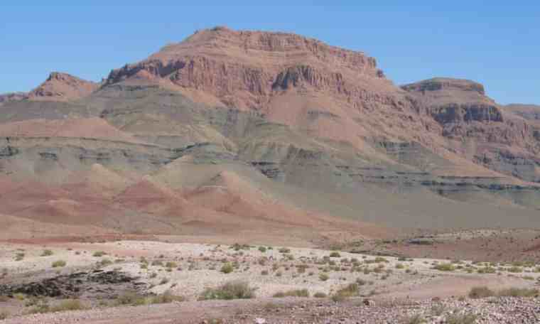
Flood basalts of the Central Atlantic Magmatic Province in Morocco (Credit: Andrea Marzoli)

The end-Triassic mass extinction, like three others of the Big Five, was thus closely associated in time with massive continental flood volcanism: indeed one of the largest such events. Within at most 10 ka large theropod dinosaurs entered the early Jurassic scene of eastern North America. The Jurassic was a greenhouse world whose atmosphere had about five times more CO2, a mean global surface temperature between 5 and 10°C higher and deep ocean temperatures 8°C above those at present. Was mantle carbon transported by CAMP magmas the main source (widely assumed until recently) or, as during the end-Permian mass extinction, was buried organic carbon responsible? A multinational group of geoscientists have closely examined samples from a one million cubic kilometre stack of intrusive basaltic sills, dated at 201 Ma, in the Amazon basin of Brazil that amount to about a third of all CAMP magmatism (Capriolo, M. and 11 others 2021. Massive methane fluxing from magma–sediment interaction in the end-Triassic Central Atlantic Magmatic ProvinceNature Communications, v. 12, article 5534; DOI: 10.1038/s41467-021-25510-w).

The team focussed on fluid inclusions in quartz within the basaltic sills that formed during the late stages of their crystallisation. The tiny inclusions contain methane gas and tiny crystals of halite (NaCl) as well as liquid water. Such was the bulk composition of the intrusive magma that the presence of around 5% of quartz in the basalts would be impossible without their magma having assimilated large volumes of silica-rich sedimentary rocks such as shales. The host rocks for the huge slab of igneous sills are sediments of Palaeozoic age: a ready source for contamination by both organic carbon and salt. The presence of methane in the inclusions suggests that more complex hydrocarbons had been ‘cracked’ by thermal metamorphism. Moreover, it is highly unlikely to have been derived from the mantle, partly because methane has been experimentally shown not to be soluble in basaltic magmas whereas CO2 is. The authors conclude that both quartz and methane entered the sills in hydrothermal fluids generated in adjacent sediments. Thermal metamorphism of the sediments would also have driven such fluids to the surface to inject methane directly to the atmosphere. Methane is 25 times as potent as carbon dioxide at trapping heat in the atmosphere, yet it combines with the hydroxyl (OH) radical to form CO2 and water vapour within about 12 years. Nevertheless during continuous emission methane traps 84 times more heat in the atmosphere than would an equivalent mass of carbon dioxide.

Calculations suggest about seven trillion tonnes of methane were generated by the CAMP intrusions in Brazil. Had the magmas mainly been extruded as flood basalts then perhaps global warming at the close of the Triassic would have been far less. Extinctions and subsequent biological evolution would have taken very different paths; dinosaurs may not have exploded onto the terrestrial scene so dramatically during the remaining 185 Ma of the Mesozoic. So it seems important to attempt an explanation of why CAMP magmas in Brazil did not rise to the surface but stayed buried as such stupendous igneous intrusions. Work on smaller intrusive sills suggests that magmas that are denser than the rocks that they pass through – as in a large, thick sedimentary basin – are forced by gravity to take a lateral ‘line of least resistance’ to intrude along sedimentary bedding. That would be aided by the enormous pressure of steam boiled from wet sedimentary rocks forcing beds apart. In areas where only thin sedimentary cover rests on crystalline, more dense igneous and metamorphic rocks, basaltic magma has a greater likelihood of rising through vertical dyke swarms to reach the surface and form lava floods.

Subduction and continental collision in the Himalaya

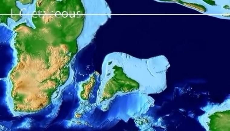
The Indian subcontinent after it separated from Madagascar in the Late Cretaceous to move northwards to its destined collision with Eurasia and the formation of the Himalaya. (Credit: Frame from an animation ©Christopher Scotese)

During the Early Cretaceous (~140 Ma ago) India, Madagascar, Antarctica and Australia parted company with Africa after 400 Ma of unity as components of the Gondwana supercontinent. By 120 Ma Antarctica and Australia split from India and Madagascar, and the Indian Ocean began to form. India moved northwards , leaving Madagascar in its wake after about 70 Ma ago. By 50 Ma the subcontinent began to collide with Eurasia, its northward motion driving before it crustal materials that eventually formed the Himalaya. This highly complex process is wonderfully documented in an animation made in 2015 by Christopher Scotese, Emeritus Professor in the Department of Earth and Environmental Sciences, Northwestern University, USA. At the start of its journey India moved northwards at a slow rate of about 5 cm per year. After 80 Ma it speeded up dramatically to 15 cm per year, about twice as fast as any modern continental drift and a pace that lasted for over 30 Ma until collision began. How could that, in a geological sense, sudden and sustained acceleration have been induced? It would have required a change in the slab-pull force that is the primary driver of plate tectonics, suggesting an increase in the amount of subduction in the Tethys Ocean that formerly lay between India and Eurasia, probably at two, now hidden destructive plate margins.

A group of geoscientists from Canada, the US and Pakistan has documented that collision in terms of the record of metamorphism experienced beneath the Himalaya as slab after slab of once near-surface rocks were driven beneath the rising orogen (Soret, M. et al. 2021. How Himalayan collision stems from subduction. Geology, v. 49, p. 894-898; DOI: 10.1130/G48803.1). The Western Himalaya has trapped a deformed and tilted magmatic rock sequence of an island arc – the Kohistan Arc – between  the Eurasian plate and a zone of crustal thickening and shortening that was thrust southward over the ancient metamorphic basement of India itself. That crust was mantled by a variety of younger sediments deposited on the Tethyan continental shelf of the northern Indian plate which became involved in the process of crustal thickening. The Kohistan Arc probably formed above one of the destructive margins that consumed the oceanic lithosphere of the now vanished Tethys Ocean. Two distinct types of rock make up the slabs stacked-up by thrusting.

The uppermost, which also forms the highest part of the Western Himalaya in the form of Nanga Parbat (at 8,126 metres the world’s ninth highest mountain) comprises rocks thought to represent Tethyan oceanic lithosphere subducted perhaps at the second destructive margin. Their mineral assemblages, especially those of eclogites, indicate that they have been metamorphosed under pressures corresponding to depths of up to 100 km, but at low temperatures along a geothermal gradient of about 7°C km-1, i.e. in a low heat-flow environment. These ultra-high pressure (UHP) metamorphic rocks formed at the start of the India-Eurasia collision. The sequence of sedimentary slabs now overridden by the UHP slab were metamorphosed at around the same time, but under very different conditions. Their burial reached only about 35 km – the normal thickness of the continental crust – and a temperature of about 600°C on a 30°C km-1 geothermal gradient. Detailed mineralogy of the UHP slab reveals that as it was driven over the metasediments it evolved to the same geothermal conditions.

Matthew Soret and his colleagues explain how this marked metamorphic duality may have arisen in rocks that are now part of the same huge thrust complex. Their results are consistent with slicing together of oceanic lithosphere in a subduction zone to form a tectonic wedge of UHP mineral assemblages at the same time as continental shelf sediments were metamorphosed under more normal geothermal conditions. This was happening just as India came into contact with Eurasia. When crustal thickening began in earnest through the inter-slicing of the two assemblages, pressure on the UHP rocks fell rapidly as a result of their being thrust over the dominantly metasedimentary shelf sequence. It also moved into a zone of normal heat flow, first heating up equally quickly and then following a path of decreasing pressure and temperature as erosion pared away the newly thickened crust. Both assemblages now became part of the same metamorphic regime. In this way a subduction system evolved to become incorporated in an orogenic zone as two continents collided; a complex process that finds parallels in other orogens such as the Alps.

Tectonics on Venus

The surface of Venus is not easily observed because of the almost opaque nature of its atmosphere. The planet is veiled by a mixture of CO2 (96.5%) and nitrogen (3.5%), with a little sulfur dioxide and noble gases. The atmosphere’s mass is almost 100 times that of the Earth’s, and has a density about 6.5% that of liquid water at the surface. The opacity stems from a turbulent upper layer of mainly sulfuric acid. Venus is the victim of runaway greenhouse conditions. Despite that, radar can penetrate the atmosphere to reveal details of its surface morphology – roughness and elevation – at a spatial resolution of 150 m. Although coarser than that available from radar remote sensing of the Earth from orbit, the Magellan data are still geologically revealing.

Earlier interpretation of Venus radar images revealed the surface to be far simpler than that of the Earth, Mars and all other rocky bodies in the Solar System. Yet it has more volcanoes than does the Earth or Mars. However, despite being subject to very little erosion – Venus is a dry world – only around 1000 impact craters have been found: far short of the number seen on Mars or the Moon. This deficiency of evidence for bombardment suggests that Venus was ‘repaved’ by vast volcanic outpourings in the geologically recent past, estimated to have occurred 300 to 600 Ma ago. This early work concluded that plate tectonics was absent; indeed that for half a billion years the lithosphere on Venus had been barely deformed. It has been suggested that Venus has been involved in megacycles of sudden, planet-wide magmatic activity separated by long periods of quiescence. This could be attributed to the lack of plate tectonics, which is the principal means that Earth continuously rids itself of heat produced at depth by decay of radioactive isotopes in the mantle. Venus has been suggested to build up internal temperatures until they reach a threshold that launches widespread partial melting of its mantle. Planet-wide eruption of magma then reduces internal temperatures.

Polygonal blocks or ‘campuses’ on the lowland surface of Venus. Note the zones of ridges that roughly parallel ‘campus’ margins. Credit: Paul K. Byrne, North Carolina State University and Sean C. Solomon, Lamont-Doherty Earth Observatory

It comes as a surprise that 26 years after Magellan plunged into the Venusian atmosphere new interpretation of its radar images suggests a completely different scenario (it may be that academic attention generally switched to research on Mars because of all the missions to the ‘Red Planet’ since Magellan disappeared). It is based on features of the surface of Venus so large that their having been missed until now may be a planetary-scale example of ‘not seeing the woods for the trees’! Geoscientists from the US, Turkey, the UK and Greece have mapped out features ranging from 100 to 1000 km across that cover the lowland parts of Venus (Byrne, P.K. et al. 2021. A globally fragmented and mobile lithosphere on Venus. Proceedings of the National Academy of Science, v. 118, article e2025919118; DOI: 10.1073/pnas.2025919118). They resemble 1950s ‘crazy paving’ or floes in Arctic pack ice, but on a much larger scale. Extending the ice floe analogy, the polygonal blocks are separated by what resemble pressure ridges that roughly parallel the block margins. Paul Byrne of North Carolina State University, USA, and co-workers also found evidence that the large blocks of lithosphere had rotated and moved laterally relative to one another: they had ‘jostled’. Moreover, some of the movement has disturbed the youngest materials on the surface.

To distinguish what seem to be characteristic of Venus’s tectonics from Earthly tectonic plates, the team hit on the name ‘campus’, meaning ‘field’ in Latin. Rather than having remained a single spherical skin of lithosphere, the surface of at least part of Venus has broken into a series of ‘campuses’. It does display tectonics, but not as we know it on planet Earth. This could be ascribed to an outcome of stress transfer from deep convective motion in the Venerean mantle. Being in the virtually non-magmatic phase of Venus’s thermal cycling, there is neither formation of new lithosphere nor subduction of old, cold plates that characterise terrestrial plate tectonics. ‘Campus’ tectonics seems likely to be another form of planetary energy and matter redistribution, and Byrne et al. have likened it to how the Earth may have functioned during the ‘missing’ 600 Ma of the Hadean Eon on Earth. But perhaps not …

The runaway greenhouse has resulted in surface temperatures on Venus being 450°C higher than on Earth: enough to melt lead. It is not just solar heat that is trapped by the atmosphere, but that from the Venerean interior. This must result in a very different geotherm (the way temperature varies with depth in a planet) from that characterising the Earth. The temperature of the beginning of mantle melting – about 1200°C – must be much shallower on Venus. On Earth that is at depths between 50 and 100 km below active plate margins and within-plate hotspots, and is not reached at all for most of the Earth that lies beneath the tectonic plates. If the mantle of Venus contained a similar complement of heat-producing isotopes to that of Earth wouldn’t we expect continual volcanism on Venus rather than the odd dribble that has been observed by Magellan? Or does the jostling of ‘campuses’ absorb the thermal energy and help direct it slowly to space by radiation through the dense, greenhouse atmosphere. Here’s another poser: If the Earth and Venus are geochemically similar and Hadean Earth went through such a phase of ‘campus tectonics’ – perhaps our world had a CO2-rich atmosphere too – what changed to allow plate tectonics here to replace that system of thermal balance? And, why hasn’t that happened on Venus? Perhaps some light will be thrown on these enigmas once a series of new missions to Venus are launched between now and the 2030s, by NASA and the European Space Agency.

The subduction pulley: a new feature of plate tectonics

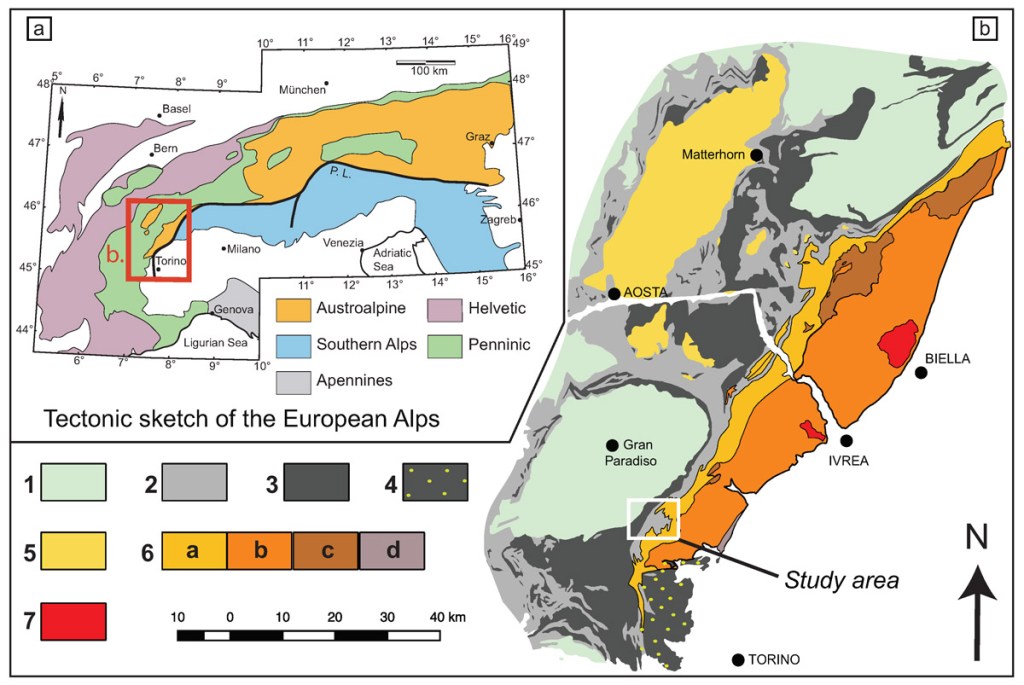
Geological map of part of the Italian Alps. The Sesia-Lanzo Zone is 6 in the Key: a – highly deformed gneisses; b – metasedimentary schists with granite intrusions; c – mafic rocks; d – mixed mantle and crystalline basement rocks. (Credit: M. Assanelli, Universita degli Studi di Milano)

To a first approximation, as they say, the basis of plate tectonics is that the lithosphere is divided up into discrete, rigid plates that are bounded by lines of divergent, convergent and sideways relative motions: constructive, destructive and conservative plate margins. These are characterised by zones of earthquakes whose senses of motion roughly correspond to the nature of each boundary: normal, reverse and strike-slip, respectively. The seismicity is mainly confined to the lithosphere in the cases of constructive and conservative boundaries (i.e. shallow) but extends as deep as 700 km into the mantle at destructive margins, thereby defining the subduction of lithosphere that remains cool enough to retain its rigidity. Although the definition assumes that there is no deformation within plates, in practice that does occur for a wide variety of reasons in the form of intra-plate seismicity, mainly within continental lithosphere. Oceanic plate interiors are much stronger and largely ‘follow the rules’; they are generally seismically quiet.

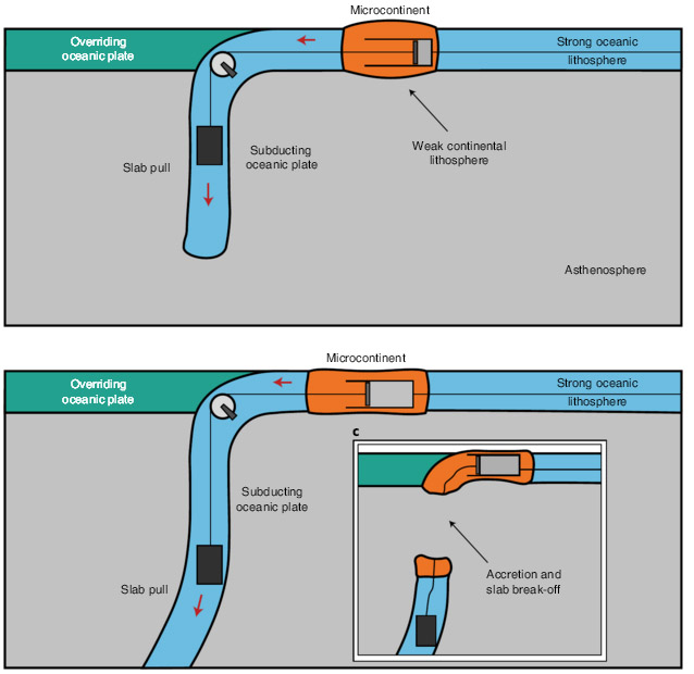
One important feature of plate tectonics is the creation of new subduction zones when an earlier one eventually ceases to function. Where these form in an oceanic setting volcanism in the overriding plate creates island arcs. They create precursors of new continental crust because the density of magmas forming the new lithosphere confers sufficient buoyancy for them to be more difficult to subduct. Eventually island arcs become accreted onto continental margins through subduction of the intervening oceanic lithosphere. Joining them in such ‘docking’ are microcontinents, small fragments spalled from much older continents because of the formation of new constructive plate margins within them. It might seem that arcs and microcontinents behave like passive rafts to form the complex assemblages of terranes that characterise continental mountain belts, such as those of western North America, the Himalaya and the Alps. Yet evidence has emerged that such docking is much more complicated (Gün, E. et al. 2021. Pre-collisional extension of microcontinental terranes by a subduction pulleyNature Geoscience, v. 14, online publication; DOI: 10.1038/s41561-021-00746-9).

Erkan Gün and colleagues from the University of Toronto and Istanbul Technical University examined one of the terranes in the Italian Alps – the Sesia-Lanzo Zone (SLZ) – thought to have been a late-Carboniferous microcontinental fragment in the ocean that once separated Africa from Europe. When it accreted the SLZ was forced downwards to depths of up to 70 km and then popped up in the latter stages of the Alpine orogeny. It is now a high-pressure, low-temperature metamorphic complex, having reached eclogite facies during its evolution. Yet its original components, including granites that contain the high-pressure mineral jadeite instead of feldspar, are still recognisable. Decades of geological mapping have revealed that the SLZ sequence shows signs of large-scale extensional tectonics. Clearly that cannot have occurred after its incorporation into southern Europe, and must therefore have taken place prior to its docking. Similar features are present within the accreted microcontinental and island-arc terranes of Eastern Anatolia in Turkey. In fact, most large orogenic belts comprise hosts of accreted terranes that have been amalgamated into older continents.

An ‘engineering’ simplification of the subduction pulley. Different elements represent slab weight (slab pull force) transmitted through a pulley at the trench to a weak microcontinent and a strong oceanic lithosphere. (Credit: Gün et al., Fig. 4)

Lithospheric extension associated with convergent plate margins has been deduced widely in the form of back-arc basins. But these form in the plate being underidden by a subduction zone. Extension of the SLZ, however, must have taken place in the plate destined to be subducted. Gün et al. modelled the forces, lithospheric structure, deformation and tectonic consequences that may have operated to form the SLZ, for a variety of microcontinent sizes. The pull exerted by the subduction of oceanic lithosphere (slab pull) would exert extensional forces on the lithosphere as it approached the destructive plate boundary. Oceanic lithosphere is very strong and would remain intact, simply transmitting slab-pull force to the weaker continental lithosphere, which ultimately would be extended. This is what the authors call a subduction ‘pulley’ system. At some stage the microcontinent fails mechanically, part of it being detached to continue with the now broken slab down the subduction zone. The rest would become a terrane accreted to the overriding plate. Subduction at this site would stop because the linkage to the plate has broken. It may continue by being transferred to a new destructive margin ‘behind’ the accreted microcontinent. This would allow other weak continental and island-arc ‘passengers’ further out on the oceanic plate eventually to undergo much the same process.

The observed complexity of tectonic terranes in other vast assemblies of them, such as the northern Pacific coast of North America and in many more ancient orogenic belts, is probably as much a result of extension before accretion as the compressional deformation suffered afterwards. The theoretical work by Erkan Gün and colleagues will surely spur tectonicians to re-evaluate earlier models of orogenesis.

Note: Figure 2 in the paper by Gün et al. shows how the width (perpendicular to the subduction zone) affects the outcomes of the subduction pulley. View an animation of a subduction pulley

When did supercontinents start forming?

Plate tectonics is easily thought of as being dominated by continental drift, the phenomenon that Alfred Wegener recognised just over a century ago. So it is at present, the major continents being separated by spreading oceans. Yet, being placed on a near-spherical planet, continents also move closer to others; eventually to collide and weld together. Part of Wegener’s concept was that modern continents formed from the breakup of a single large one that he called Pangaea; a supercontinent. The current drifting apart began in earnest around the end of the Triassic Period (~200 Ma), after 200 Ma  of Pangaea’s dominance of the planet along with a single large ocean (Panthalassa) covering 70% of the Earth’s surface. Wegener was able to fit Pangaea together partly on the basis of evidence from the continents’ earlier geological history. In particular the refit joined up zones of intense deformation from continent to continent. Although he did not dwell on their origin, subsequent research has shown these zones were the lines of earlier collisions between older continental blocks, once subduction had removed the intervening oceanic lithosphere; Pangaea had formed from an earlier round of continental drift. Even older collision zones within the pre-Pangaea continental blocks suggested the former existence of previous supercontinents.

Aided by the development of means to divine the position of the magnetic poles relative to differently aged blocks on the continents, Wegener’s basic methods of refitting have resulted in the concept of supercontinent cycles of formation and break-up. It turns out that supercontinents did not form by all earlier continental clanging together at one time. The most likely scenario is that large precursors or ‘megacontinents’ (Eurasia is the current example) formed first, to which lesser entities eventually accreted  A summary of the latest ideas on such global tectonic cycles appeared in the November 2020 issue of Geology (Wang, c. et al. 2020. The role of megacontinents in the supercontinent cycle. Geology, v. 49  p. 402-406; DOI: 10.1130/G47988.1). Chong Wang of the Chinese Academy of Sciences and colleagues from Finland and Canada identify three such cycles of megacontinent formation and the accretion around them of the all-inclusive supercontinents of Columbia, Rodinia and Pangaea since about 1750 Ma (Mesoproterozoic). They also suggestion that a future supercontinent (Amasia) is destined to agglomerate around Eurasia.

Known megacontinents in relation to suggested supercontinents since the Mesoproterozoic (credit: Wang et al.; Fig 2)

The further back in time, the more cryptic are ancient continent-continent collision zone or sutures largely because they have been re-deformed long after they formed. In some cases younger events that involved heating have reset their radiometric ages. The oldest evidence of crustal deformation lies in cratons, where the most productive source of evidence for clumping of older continental masses is the use of palaeomagnetic pole positions. This is not feasible for the dominant metamorphic rocks of old suture zones, but palaeomagnetic measurements from old rocks that have been neither deformed nor metamorphosed offer the possibility of teasing out ancient supercontinents. Commonly cratons show signs of having been affected by brittle extensional deformation, most obviously as swarms of vertical sheets or dykes of often basaltic igneous rocks. Dykes can be dated readily and do yield reliable palaeomagnetic pole positions. Some cratons have multiple dyke swarms. For example the Archaean Yilgarn  Craton of Western Australia, founded on metamorphic and plutonic igneous crust that formed by tectonic accretion between 3.8 to 2.7 Ga, has five of them spanning 1.4 billion years from late-Archaean (2.6 Ga) to Mesoproterozoic (1.2 Ga). Throughout that immense span of time the Yilgarn remained as a single continental block. Also, structural trends end abrubtly at the craton margins, suggesting that it was once part of a larger ‘supercraton’ subsequently pulled apart by extensional tectonics.  The eleven known cratons show roughly the same features.

On the strength of new, high quality pole positions from dykes of about the same ages (2.62 and 2.41 Ga) cutting the Yilgarn and Zimbabwe cratons, geoscientists from Australia, China, Germany, Russia and Finland, based at Curtin University in Western Australia, have attempted to analyse all existing Archaean and Palaeoproterozoic pole positions (Liu, Y. et al. 2021. Archean geodynamics: Ephemeral supercontinents or long-lived supercratons. Geology, v. 49  ; DOI: 10.1130/G48575.1). The Zimbabwe and Yilgarn cratons, though now very far apart, were part of the same supercraton from at least 2.6 Ga ago. Good cases can be made for several other such large entities, but attempting fit them all together as supercontinents by modelling is unconvincing. The modelled fit for the 2.6 Ga datum is very unlike that for 2.4 Ga; in the intervening 200 Ma all the component cratons ould have had to shuffle around dramatically, without the whole supercontinent edifice breaking apart. However, using the data to fit cratons together at two supercratons does seem to work, for the two assemblies remain in the same configurations for both the 2.6 and 2.4 Ga data.

Interestingly, all cratonic components of one of the supercratons show geological evidence of the major 2.4 Ga glaciation, whereas those of the other show no such climatic indicator. Yet the entity with glacial evidence was positioned at low latitudes around 2.4 Ga, the ice-free one spanning mid latitudes. This may imply that the Earth’s axial tilt was far higher than at present. The persistence of two similar sized continental masses for at least 200 Ma around the end of the Archaean Eon also hints at a different style of tectonics from that with which geologists are familiar. Only palaeomagnetic data from the pre 2.6 Ga Archaean can throw light on that possibility. That requires older, very lightly or unmetamorphosed rocks to provide palaeopole positions. Only two cratons, the Pilbara of Western Australia and the Kaapvaal of South Africa, are suitable. The first yielded the oldest-known pole dated at 3.2 Ga, the oldest from the second is 2.7 Ga. A range of evidence suggests that Pilbara and Kaapvaal cratons were united during at least the late Archaean.

The only answer to the question posed by this item’s title is ‘There probably wasn’t a single supercontinent at the end of the Archaean, but maybe two megacontinents or supercratons’. Lumps of continental lithosphere would move and – given time – collide once more than one lump existed, however the Earth’s tectonics operated …

The oldest known impact structure (?)

That large, rocky bodies in the Solar System were heavily bombarded by asteroidal debris at the end of the Hadean Eon (between 4.1 to 3.8 billion years ago) is apparent from the ancient cratering records that they still preserve and their matching with dating of impact-melt rocks on the Moon. Being a geologically dynamic planet, the Earth preserves no tangible, indisputable evidence for this Late Heavy Bombardment (LHB), and until quite recently could only be inferred to have been battered in this way. That it actually did happen emerged from a study of tungsten isotopes in early Archaean gneisses from Labrador, Canada (see: Tungsten and Archaean heavy bombardment, August 2002; and Did mantle chemistry change after the late heavy bombardment? September 2009). Because large impacts deliver such vast amounts of energy in little more than a second (see: Graveyard for asteroids and comets, Chapter 10 in Stepping Stones) they have powerful consequences for the Earth System, as witness the Chicxulub impact off the Yucatán Peninsula of Mexico that resulted in a mass extinction at the end of the Cretaceous Period. That seemingly unique coincidence of a large impact with devastation of Earth’s ecosystems seems likely to have resulted from the geology beneath the impact; dominated by thick evaporite beds of calcium sulfate whose extreme heating would have released vast amounts of SO2 to the atmosphere. Its fall-out as acid rain would have dramatically affected marine organisms with carbonate shells. Impacts on land would tend to expend most of their energy throughout the lithosphere, resulting in partial melting of the crust or the upper mantle in the case of the largest such events.

The further back in time, the greater the difficulty in recognising visible signs of impacts because of erosion or later deformation of the lithosphere. With a single, possible exception, every known terrestrial crater or structure that may plausibly be explained by impact is younger than 2.5 billion years; i.e. they are post-Archaean. Yet rocky bodies in the Solar System reveal that after the LHB the frequency and magnitude of impacts steadily decreased from high levels during the Archaean; there must have been impacts on Earth during that Eon and some may have been extremely large. In the least deformed Archaean sedimentary sequences there is indirect evidence that they did occur, in the form of spherules that represent droplets of silicate melts (see: Evidence builds for major impacts in Early Archaean; August 2002, and Impacts in the early Archaean; April 2014), some of which contain unearthly proportions of different chromium isotopes (see: Chromium isotopes and Archaean impacts; March 2003). As regards the search for very ancient impacts, rocks of Archaean age form a very small proportion of the Earth’s continental surface, the bulk having been buried by younger rocks. Of those that we can examine most have been subject to immense deformation, often repeatedly during later times.

The Archaean geology of part of the Akia Terrane (Manitsoq area) in West Greenland. The suggested impact structure is centred on the Finnefjeld Gneiss (V symbols) surrounded by highly deformed ultramafic to mafic igneous rocks. (Credit: Jochen Kolb, Karlsruhe Institute of Technology, Germany)

There is, however, one possibly surviving impact structure from Archaean times, and oddly it became suspected in one of the most structurally complex areas on Earth; the Akia Terrane of West Greenland. Aeromagnetic surveys hint at two concentric, circular anomalies centred on a 3.0 billion years-old zone of grey gneisses (see figure) defining a cryptic structure. It is is surrounded by hugely deformed bodies of ultramafic and mafic rocks (black) and nickel mineralisation (red). In 2012 the whole complex was suggested to be a relic of a major impact of that age, the ultramafic-mafic bodied being ascribed to high degrees of impact-induced melting of the underlying mantle. The original proposers backed up their suggestion with several associated geological observations, the most crucial being supposed evidence for shock-deformation of mineral grains and anomalous concentrations of platinum-group metals (PGM).

A multinational team of geoscientists have subjected the area to detailed field surveys, radiometric dating, oxygen-isotope analysis and electron microscopy of mineral grains to test this hypothesis (Yakymchuck, C. and 8 others 2020. Stirred not shaken; critical evaluation of a proposed Archean meteorite impact in West Greenland. Earth and Planetary Science Letters, v. 557, article 116730 (advance online publication); DOI: 10.1016/j.epsl.2020.116730). Tectonic fabrics in the mafic and ultramafic rocks are clearly older than the 3.0 Ga gneisses at the centre of the structure. Electron microscopy of ~5500 zircon grains show not a single example of parallel twinning associated with intense shock. Oxygen isotopes in 30 zircon grains fail to confirm the original proposers’ claims that the whole area has undergone hydrothermal metamorphism as a result of an impact. All that remains of the original suggestion are the nickel deposits that do contain high PGM concentrations; not an uncommon feature of Ni mineralisation associated with mafic-ultramafic intrusions, indeed much of the world’s supply of platinoid metals is mined from such bodies. Even if there had been an impact in the area, three phases of later ductile deformation that account for the bizarre shapes of these igneous bodies would render it impossible to detect convincingly.

The new study convincingly refutes the original impact proposal. The title of Yakymchuck et al.’s paper aptly uses Ian Fleming’s recipe for James Bond’s tipple of choice; multiple deformation of the deep crust does indeed stir it by ductile processes, while an impact is definitely just a big shake. For the southern part of the complex (Toqqusap Nunaa), tectonic stirring was amply demonstrated in 1957 by Asger Berthelsen of the Greenland Geological Survey (Berthelsen, A. 1957. The structural evolution of an ultra- and polymetamorphic gneiss-complex, West Greenland. Geologische Rundschau, v. 46, p. 173-185; DOI: 10.1007/BF01802892). Coming across his paper in the early 60s I was astonished by the complexity that Berthelsen had discovered, which convinced me to emulate his work on the Lewisian Gneiss Complex of the Inner Hebrides, Scotland. I was unable to match his efforts. The Akia Terrane has probably the most complicated geology anywhere on our planet; the original proposers of an impact there should have known better …

Weak lithosphere delayed the formation of continents

There are very few tangible signs that the Earth had continents at the surface before about 4 billion years (Ga) ago. The most cited evidence that they may have existed in the Hadean Eon are zircon grains with radiometric ages up to 4.4 Ga that were recovered from much younger sedimentary rocks in Western Australia. These tiny grains also show isotopic anomalies that support the existence of continental material, i.e. rocks of broadly granitic composition, only 100 Ma after the Earth formed (see: Zircons and early continents no longer to be sneezed at; February 2006). So, how come relics of such early continents have yet to be discovered in the geological record? After all granitic rocks – in the broad sense – which form continents are so less dense than the mantle that modern subduction is incapable of recycling them en masse. Indeed, mantle convection of any type in the hotter Earth of the Hadean seems unlikely to have swallowed continents once they had formed. Perhaps they are hiding in another guise among younger rocks of the continental crust. But, believe me; geologists have been hunting for them, to no avail, in every scrap of existing continental crust since 1971 when gneisses found in West Greenland by New Zealander Vic McGregor turned out to be almost 3.8 Ga old. This set off a grail-quest, which still continues, to negate James Hutton’s ‘No vestige of a beginning …’ concept of geological time.

There is another view. Early continental lithosphere may have returned to the mantle piece by piece by other means. One that has been happening since the Archaean is as debris from surface erosion and its transportation to the ocean floor, thence to be subducted along with denser material of the oceanic lithosphere. Another possibility is that before 4 Ga continental lithosphere had far less strength than characterised it in later times; it may have been continually torn into fragments small enough for viscous drag to defy buoyancy and consign them into the mantle by convective processes. Two things seem to confer strength on continental lithosphere younger than 4 billion years: its depleted surface heat flow and heat-production that stem from low concentrations of radioactive isotopes of uranium, thorium and potassium in the lower crust and sub-continental mantle; bolstering by cratons that form the cores of all major continents. Three geoscientists at Monash University in Victoria, Australia have examined how parts of early convecting mantle may have undergone chemical and thermal differentiation (Capitanio, F.A. et al. 2020. Thermochemical lithosphere differentiation and the origin of cratonic mantle.  Nature, v. 588, p. 89-94; DOI: 10.1038/s41586-020-2976-3). These processes are an inevitable outcome of the tendency for mantle melting to begin as it becomes decompressed when pressure decreases when it rises during convection. Continual removal of the magmas produced in this way would remove not only much of the residue’s heat-producing capacity – U, Th and K preferentially enter silicate melts – but also its content of volatiles, especially water. Even if granitic magmas were completely recycled back to the mantle by the greater vigour of the hot, early Earth, at least some of the residue of partial melting would remain. Its dehydration would increase its viscosity (strength). Over time this would build what eventually became the highly viscous thick mantle roots (tectosphere) on which increasing amounts of the granitic magmas could stabilise to establish the oldest cratons. Over time more and more such cratonised crust would accumulate, becoming increasingly unlikely to be resorbed into the mantle. Although cratons are not zoned in terms of the age of their constituent rocks, they do jumble together several billion years’ worth of continental crust in what used to be called ‘the Basement Complex’.

Development of depleted and viscous sub-continental mantle on the early Earth – a precedes b – TTG signifies tonalite-trondhjemite-granodiorite rocks typical of Archaean cratons (Credit, Capitanio et al.; Fig 5)

Early in this process, heat would have made much of the lithosphere too weak to form rigid plates and the tectonics with which geologists are so familiar from the later parts of Earth’s history. The evolution that Capitanio et al. propose suggests that the earliest rigid plates were capped by Archaean continental crust. That implies subduction of oceanic lithosphere starting at their margins, with intra-oceanic destructive plate margins and island arcs being a later feature of tectonics. It is in the later, Proterozoic Eon that evidence for accretion of arc terranes becomes obvious, plastering their magmatic products onto cratons, further enlarging the continents.

Kerguelen Plateau: a long-lived large igneous province

It’s easy to think of the Earth’s largest outpourings of lava as being restricted to the continents; continental flood basalts with their spectacular stepped topography made up of hundreds of individual massive flows and intervening soil horizons. The Deccan Traps of western India are the epitome, having been so named by natural scientists of the late 18th century from the Swedish word for ‘stairs’ (trappa). Examples go back to the Proterozoic Era, younger ones still retaining much of their original form as huge plateaus. All began life within individual tectonic plates, although some presaged continental break-up and the formation of new oceanic spreading centres. They must have been spectacular events, up to millions of cubic kilometres of magma belched out in a few million years. They have been explained as manifestations of plumes of hot mantle rock rising from as deep as the core-mantle boundary. Unsurprisingly, the biggest continental flood-basalt outpourings coincided with mass extinction events. Otherwise known as large igneous provinces (LIPs), they are not the only signs of truly huge production of magma by partial melting in the mantle. The biggest LIP, with an estimated volume of 80 million km3, lies deep beneath the Western Pacific Ocean. To the northeast of New Guinea, the Ontong Java Plateau formed over a period of about 3 Ma in the mid-Cretaceous (~120 Ma) and blanketed one percent of the Earth’s solid surface with lavas erupted at a rate of 22 km3 per year. Possibly because this happened on the Pacific’s abyssal plains beneath around 4 km of sea water, there is little sign of any major perturbation of mid-Cretaceous life, but it is associated with evidence for global oceanic anoxia. Ontong Java isn’t the only oceanic LIP. Bearing in mind that oceanic lithosphere only goes back to the start of the Jurassic Period (200 Ma) – earlier material has largely been subducted – they are not as abundant as continental flood-basalt provinces. One of them is the Kerguelen Plateau 3000 km to the SE of Australia, which is about three times the area of Japan and the second largest LIP of the Phanerozoic Eon. The Plateau was split into two large fragments while sea-floor spreading progressed along the Southeast Indian Ridge.

Bathymetry of the Indian Ocean south-west of Australia, showing the Kerguelen Plateau and South-east Indian Ridge. The red arrows show the amount of sea-floor spreading on either side of the Ridge since it began to open. The pale blue area at the NE end of the arrow was formerly part of the Plateau (credit: Google Earth)

Long regarded as a microcontinental  fragment left when India parted company with Antarctica – based on isolated occurrences of gneisses – there is evidence that during the formation of the Kerguelen LIP the basalts rose above sea level. Because earlier radiometric dating of basalts from ocean-floor drill cores were of low quality, an Australian-Swedish group of geoscientists have re-evaluated those data and supplemented them with 25 new Ar-Ar dates from 12 sites (Jiang, Q. et al. 2020. Longest continuously erupting large igneous province driven by plume-ridge interaction. Geology, v. 48, online; DOI: 10.1130/G47850.1). Rather than a cluster of ages around a short time range as expected from the short life of most other LIPs, those from Kerguelen span 32 Ma during the Cretaceous (from 122 to 90 Ma). The magmatic pulse began at roughly the same time as that of Ontong Java, but continued for much longer. Smaller oceanic LIPs do seem to have lingered for unusually lengthy periods, but all seem to have constructed in several separate pulses. Large-volume eruption at Kerguelen was continuous for at least 32 Ma; the drilling did not penetrate the oldest of the plateau basalts. It seems that the Kerguelen LIP is unique in that respect and requires an explanation other than simply a mantle plume, however large.

Jiang et al. suggest a model of continuous interaction between a long-lived plume and the development of the Southeast Indian Ridge oceanic spreading centre. Their model involves the line of continental splitting between India and Antarctic taking place close to a major deep-mantle plume at around 128 Ma. There is nothing unique about that; incipient ocean rifting in the Horn of Africa and formation of the Red Sea and Gulf of Aden ridges is currently associated with the active Afar plume. This was followed by a kind of tectonic shuffling of the Ridge back and forth across the head of the Kerguelen plume: not far different from the Palaeogene North Atlantic LIP, where the mid-Atlantic Ridge and the still-active Iceland plume, except the ridge and plume seem more intimately involved there. However, there are probably many subtle relationships between plumes and various kind of oceanic plate margins that are still worth exploring. Since the first discovery of mantle plumes as an explanation for volcanic island chains (e.g. the Hawaiian chain) where volcanism becomes progressively older in the direction of plate movement, there is still much to discover.

See also: Magma .conveyor belt’ fuelled world’s longest erupting supervolcanoes (Science Daily, 4 November 2020)

Environmental change and early-human innovation

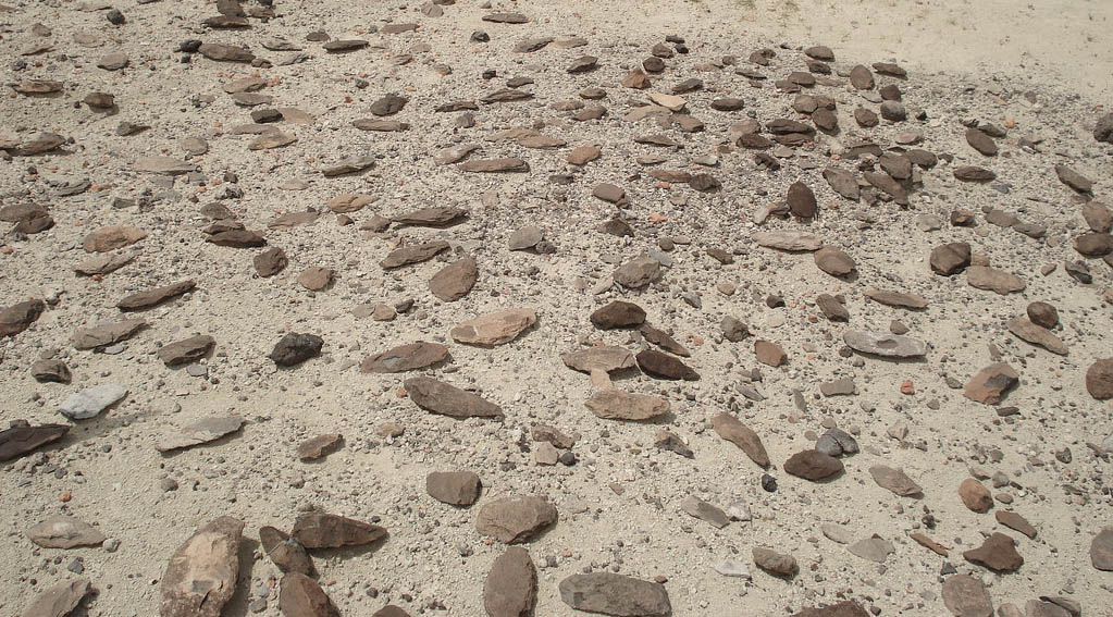
Acheulean biface tools strewn on a bedding surface in the Olorgesailie Basin, Kenya (credit: mmercedes_78 Flickr)

The Olorgesailie Basin in Southern Kenya is possibly the world’s richest source for evidence of ancient stone-tool manufacture. For early humans, it certainly was rich in the necessary resources from which to craft tools. Lying in East Africa’s active rift system, its stratigraphy contains abundant beds of hydrothermal silica (chert), deposited by hot springs, and flows of fine grained lavas. Its sediments spanning the last 1.2 million years show that the Basin hosted lakes and extensive river systems for the earlier part of this period: it was rich in food resources too. The tools, together with bones from dismembered prey, bear witness to long-term human occupation, but hominin remains themselves have yet to be discovered. The time span suggests early occupation by Homo erectus, who probably manufactured Acheulean biface stone tools in large quantities that litter the surface at some archaeological sites.

There is a break in the stratigraphic sequence from about 500 to 320 thousand years ago caused by erosion during a period of tectonic uplift. Younger sediments reveal a striking change in archaeology. The earlier large cutting tools give way to a more diverse ‘toolkit’ of smaller tools produced by more sophisticated techniques than those used to make the Acheulean ‘hand axes’. In African archaeological parlance, the <320 ka-old tools mark the onset of the Middle Stone Age (NB not equivalent to the much younger Mesolithic of Europe). The sedimentary gap also marks what seems to have been very different human behaviour. The stone resources used in the 1.2 to 0.5 Ma sequence were local: no more than 5 km from the tool-yielding sites. After the gap a much more varied range of lithologies was used, from as far afield as 95 km. Not only that, but rock unsuitable for tools appears: soft pigments such as hematite.

The foregoing was known from three major papers that appeared in March 2018 (see: Human evolution and revolution in Africa, March 2018 – specifically the section Hominin cultural revolution 320,000 years ago). Now, many members of the teams who produced that published evidence report detailed analysis of samples from a deep drill core through the stratigraphy in a similar, nearby basin (Potts, R. and 21 others 2020. Increased ecological resource variability during a critical transition in hominin evolutionScience Advances, v. 6, article eabc8975; DOI:10.1126/sciadv.abc8975). As well as calibrating the timing of stratigraphic changes using 40Ar/39Ar dating from 22 volcanic layers, the team analysed sedimentary structures, body- and trace fossils, variations in sediment geochemistry, palaeobotany and carbon isotopes, to suggest variations in environmental conditions and ecology throughout the section in greater detail than previously achieved anywhere in Africa.

They conclude that as well as a change in topography resulting from the 500-320 ka period of tectonic uplift and erosion, the climate of this part of East Africa became more unstable. Combined, these two factors transformed the ecosystems of the Olorgesailie Basin. Between 1.2 to 0.5 Ma the Acheulean tool makers inhabited dominantly grassy plains with substantial, permanent lakes – a stable period of 700 thousand years, well suited to large herbivores and thus to these early humans. Tectonic and climatic change disrupted a ‘land of plenty’; the herbivores left to be replaced by smaller prey animals; vegetation shifted back and forth from grassland to woodland with the unstable climate; lakes became smaller and ephemeral. The problem in linking environmental change to changed human practices in this case, however, is the 180 thousand-year gap in the geological record. Lead author Richard Potts, director of the Human Origins Program at the Smithsonian’s National Museum of Natural History, and his team suggest that the change contributed to the ecological flexibility of the probable Homo sapiens who left the fancier, more diverse tools during the later phase. Yet 1.6 million years beforehand early H. erectus had sufficient flexibility to cross 30 to 40 degrees of latitude and end up on the shores of the Black Sea in Georgia! The likely late-stage H. erectus of Olorgesailie may have moved out around 500 ka ago and sometime later early H. sapiens moved in with new technology developed elsewhere. We know that the earliest known anatomically modern humans lived in Morocco at around 315 ka (see: Origin of anatomically modern humans, June 2017): but we don’t know what tools they had or where they went next. There are all sorts of possibilities that cannot be addressed by even the most intricate analysis of secondary evidence. The important issue seems, I think, to centre on the transition from erects to sapiens, in anatomical, cognitive and behavioural contexts, via some intermediary such as H. antecessor, to which this study can contribute very little. That needs complete stratigraphic records: ironically, the other basin from which the core was drilled is apparently more complete, especially for the 500 to 320 ka ‘gap’. That seems likely to offer more potential. Yet, such big questions also demand a much broader brush: perhaps on a continental scale. It’s to early to tell …

See also: Turbulent era sparked leap in human behavior, adaptability 320,000 years ago (Science Daily,21 October 2020)

How continental keels and cratons may have formed

There is Byzantine ring to the word craton: hardly surprising as it stems from the Greek kratos meaning ‘might’ or ‘strength’. Yes, the ancient cores of the continents were well named, for they are mighty. Some continents, such as Africa, have several of them: probably relics of very ancient supercontinents that have split and spread again and again. Cratons overlie what are almost literally the ‘keels’ of continents. Unlike other mantle lithosphere beneath continental crust (150 km on average) cratonic lithosphere extends down to 350 km and is rigid. Upper mantle rocks at that depth elsewhere are mechanically weaker and constitute the asthenosphere. Geologists only have evidence from the near-surface on which to base ideas of how cratons formed. Their exposed rocks are always Precambrian in age, from 1.5 to 3.5 billion years old, though in some cases they are covered by a thin veneer of later sedimentary rocks that show little sign of deformation. No cratons formed after the Palaeoproterozoic and they are the main repositories of Archaean rock. Their crust is thicker than elsewhere and dominated at the surface by crystalline rocks of roughly granitic composition. Cratons have the lowest amount of heat flowing out from the Earth’s interior; i.e. heat produced by the decay of long-lived radioactive isotopes of uranium, thorium and potassium. This relative coolness provides an explanation for the rigidity of cratons relative to younger continental lithosphere. Because granitic rocks are well-endowed with heat-producing isotopes, the implication of low heat flow is that the deeper parts of the crust are strongly depleted in them. As a result the deep mantle in cratonic keels is at higher pressure and lower temperature than elsewhere beneath the continental surface. Ideal conditions for the formation of diamonds in mantle rock, so that cratonic keels are their main source – they get to the surface in magma pipes when small amounts of partial melting take place in the lithospheric mantle.

The low heat flow through cratons beckons the idea that the heat-producing elements U, Th and K were at some stage driven from depth. An attractive hypothesis is that they were carried in low-density granitic magmas formed by partial melting of mantle lithosphere during the Precambrian that rose to form continental crust. Yet there is an abundance of younger granite plutons that are associated with thinner continental lithosphere. This seeming paradox suggests different kinds of magmagenesis and tectonics during the early Precambrian. Russian and Australian geoscientists have proposed an ingenious explanation (Perchuk, A.L. et al. 2020. Building cratonic keels in Precambrian plate tectonics. Nature, v. 586, p. 395-401; DOI: 10.1038/s41586-020-2806-7). The key to their hypothesis lies in the 2-layered nature of mantle keels beneath cratons, as revealed by seismic studies. Modelling of the data suggests that the layering resulted from different degrees of partial melting in the upper mantle during Precambrian subduction.

Development of a cratonic keel from melt-depleted lithospheric mantle during early Precambrian subduction. Mantle temperature is 250°C higher than it is today. The oceanic lithosphere being subducted in (a) has become a series of stagnant slabs in (b) (credit: Perchuk et al.; Fig. 2)

Perchuk et al. suggest that high degrees of partial melting of mantle associated with subduction zones produced the bulk of magma that formed the Archaean and Palaeoproterozoic crust. This helps explain large differences between the bulk compositions of ancient and more recent continental crust, which involves less melting. The residue left by high degrees of melting of mantle rock in the early Precambrian would have had a lower density than the rest of the mantle. While older oceanic crust at ancient subduction zones would be transformed to a state denser than the mantle as a whole and thus able to sink, this depleted lithospheric mantle would not. In its hot ductile state following partial melting, this mantle would be ‘peeled’ from the associated oceanic crust to be emplaced below. The figure shows one of several outcomes of a complex magmatic-thermomechanical model ‘driven’ by assumed Archaean conditions in the upper mantle and lithosphere An excellent summary of modern ideas on the start of plate tectonics and evolution of the continents is given by:Hawkesworth, C.J., Cawood, P.A. & Dhuime, B. 2020. The evolution of the continental crust and the onset of plate tectonics. In Topic: The early Earth crust and its formation, Frontiers in Earth Sciences; DOI: 10.3389/feart.2020.00326

Diamonds and the deep carbon cycle

When considering the fate of the element carbon and CO2, together with all their climatic connotations, it is easy to forget that they may end up back in the Earth’s mantle from which they once escaped to the surface. In fact all geochemical cycles involve rock, so that elements may find their way into the deep Earth through subduction, and they could eventually come out again: the ‘logic’ of plate tectonics. Teasing out the various routes by which carbon might get to mantle is not so easily achieved. Yet one of the ways it escapes is through the strange magma that once produced kimberlite intrusions, in the form of pure-carbon crystals of diamond that kimberlites contain. A variety of petrological and geochemical techniques, some hinging on other minerals that occur as inclusions, has allowed mineralogists to figure out that diamonds may form at depths greater than about 150 km. Most diamonds of gem quality formed in unusually thick lithosphere beneath the stable, and relatively cool blocks of ancient continental crust known as cratons, which extends to about 250 km. But there are a few that reflect formation depths as great as 800 km that span two major discontinuities in the mantle (at 410 and 660 km depth). These transition zones are marked by sudden changes in seismic speed due to pressure-induced transformations in the structure and density of the main mantle mineral, olivine.

Diamond crystal containing a garnet and other inclusions (Credit: Stephen Richardson, University of Cape Town, South Africa)

Carbon-rich rocks that may be subducted are not restricted to limestones and carbon-rich mudstones. Far greater in mass are the basalts of oceanic crust. Not especially rich in carbon when they crystallised as igneous rocks, their progress away from oceanic spreading centres exposes them to infiltration by ocean water. Once heated, aqueous fluids cause basalts to be hydrothermally altered. Anhydrous feldspars, pyroxenes and olivines react with the fluids to break down to hydrated-silicate clays and dissolved metals. Dissolved carbon dioxide combines with released calcium and magnesium to form pervasive carbonate minerals, often occupying networks of veins. So there has been considerable dispute as to whether subducted sediments or igneous rocks of the oceanic crust are the main source of diamonds. Diamonds with gem potential form only a small proportion of recovered diamonds. Most are only saleable for industrial uses as the ultimate natural abrasive and so are cheaply available for research. This now centres on the isotopic chemistry of carbon and nitrogen in the diamonds themselves and the various depth-indicating silicate minerals that occur in them as minute inclusions, most useful being various types of garnet.

The depletion of diamonds in ‘heavy’ 13C once seemed to match that of carbonaceous shales and the carbonates in fossil shells, but recent data from carbonates in oceanic basalts reveals similar carbon, giving three possibilities. Yet, when their nitrogen-isotope characteristics are taken into account, even diamonds that formed at lithospheric depths do not support a sedimentary source (Regier, M.E. et al. 2020. The lithospheric-to-lower-mantle carbon cycle recorded in superdeep diamonds. Nature, v. 585, p. 234–238; DOI: 10.1038/s41586-020-2676-z). That leaves secondary carbonates in subducted oceanic basalts as the most likely option, the nitrogen isotopes more reminiscent of clays formed from igneous minerals by hydrothermal processes than those created by weathering and sedimentary deposition. However, diamonds with the deepest origins – below the 660 km mantle transition zone – suggest yet another possibility, from the oxygen isotopes of their inclusions combined with those of C and N in the diamonds. All three have tightly constrained values that most resemble those from pristine mantle that has had no interaction with crustal rocks. At such depths, unaltered mantle probably contains carbon in the form of metal alloys and carbides. Regier and colleagues suggest that subducted slabs reaching this environment – the lower mantle – may release watery fluids that mobilise carbon from such alloys to form diamonds. So, I suppose, such ultra-deep diamonds may be formed from the original stellar stuff that accreted to form the Earth and never since saw the ‘light of day’.

Submarine landslides and formation of the East African Rift System

The East African Rift System (Credit: P.C. Neupane, M.Sc thesis 2011; Fig. 1)

East Africa is traversed from the Afar Depression in the north to Malawi in southern Africa by several great depressions bounded by active normal fault systems: grabens in the old terminology. They are regions of active crustal extension and thinning decorated by chains of active volcanoes. The last 50 years has witnessed more than 3400 major earthquakes (magnitude 4 to 7); unsurprising for the Earth’s largest active continental rift system. In Afar, the East African Rift system links to two others that have extended sufficiently to create oceanic crust: the Red Sea and the Gulf of Aden rifts. Afar is the site of the best documented tectonic triple junction. In Ethiopia, the rifting began after the whole of the Horn of Africa and Yemen had been smothered by continental flood basalts 30 Ma ago, during the Oligocene Epoch. The East African rifts are repositories for younger sediments that contain a continuous record of hominid evolution from about 5 Ma ago. This is no coincidence, for adjacent bulging of the continental crust resulted both from its unloading by thinning along the rifts and the buoyancy conferred by high heat flow in the mantle beneath. The uplifted areas have risen as high as 4 kilometres elevation (in Ethiopia), and present some of the world’s most spectacular land forms. This N-S barrier disrupted earlier climatic patterns that had much of tropical Africa blanketed by dense woodland and resulted in a strongly seasonal climate during the last few million years and the development of open savannah land. Put simply, open grassland with widely spaced trees was no place for diminutive forest apes to scamper on all-fours. Being able to leg-it nimbly on two gave the apes that developed such a gait a decisive evolutionary advantage: the rest, as they say, is human evolutionary history.

The extension and rapid uplift along the rift flanks to this day pose severe risk of landslides. Indeed, some are so large as to resemble fault blocks in their own right. Vast amounts of the upper crust have been stripped off by rapid erosion driven by the uplift. The debris has not only ended-up on the rift floors as sedimentary fill but far more has made its way eastward to be deposited on the Indian Ocean continental shelf. Until recently, piecing together the history of rifting and uplift has been restricted to the rifts themselves and their adjacent flanks. Such terrains have extremely complex and usually discontinuous geological sequences, so signs of the onset of extensional tectonics and uplift may differ from region to region. Agreement is limited to some time between 25 and 17 Ma. The whole tectonic process may, in fact, have begun at different times along the length of the rift. A clearer picture should emerge from studies of the post-30 Ma sedimentary pile along the Indian Ocean continent shelf. A sure-fire way of getting the needed data is from offshore areas that are prospective for oil and natural gas. Such is the case off the Tanzanian coastline at the southern limit of the rift system.

Seismic reflection profile parallel to the Tanzanian coastline with the Mafia mega-slide highlighted in green (Credit: Maselli et al. 2020; Fig. 5) Click to view full resolution

The Tanzania Petroleum Development Corporation and Shell have conducted seismic reflection surveys and drilled some test wells to the SE of Zanzibar Island, an area of major deposition from the eastward flowing Ruaha–Rufiji and Rovuma Rivers. Vittorio Maselli of Dalhousie University in Halifax Nova Scotia and colleagues from the UK, Italy and the Netherlands analysed a wealth of data from these surveys, to discover one of the biggest landslides on Earth (Maselli, V. and 10 others 2020. Large-scale mass wasting in the western Indian Ocean constrains onset of East African rifting. Nature Communications, v. 11, article 3456; DOI: 10.1038/s41467-020-17267-5). The Mafia mega-slide is represented in seismic profiles by a sedimentary unit, up to 300 m thick. It has a highly irregular base that cuts across strata in late-Oligocene to early-Miocene (25-23 Ma) sediments. It covers an area of more than 11,600 km2 and has a volume of at least 2500 km3. The unit’s upper surface is also irregular, suggesting that the unit’s thickness varies considerably. Younger sediments are draped across the irregular top of the slide body. In other, parallel sections the deposit is absent. Unlike the clearly bedded nature of sediments above and below it, the seismic response of the slide deposit is featureless, except for zones of chaotic stratification that reveal slump-folds. Nor is this the only sign of major submarine slides: there are others of lesser extent that predate the base of the Pliocene (5.3 Ma).

A mass movement of this magnitude would have generated a tsunami larger than that which possibly wiped out Mesolithic habitation on the east coast of Britain 8200 years ago due to the even larger Storegga Slide at the edge of the Norwegian continental shelf. The Mafia slide event would have flooded wide tracts of the East African coast. Its estimated age, between 22.9 to 19.8 Ma, is roughly coeval with the initiation of volcanism in the Tanzanian segment of the East African Rift and the onset of rifting and uplift of its flanks. It was probably launched by a major earthquake (>7 on the Richter scale). Such is the pace of current deposition and the thickness of sedimentary build-up since the Pliocene, there is a danger of future slides, albeit of lesser magnitude: the system continues to be seismically active, with recently recorded quakes offshore of Tanzania.

What controls the height of mountains?

‘Everybody knows’ that mountains grow: the question is, ‘How?’ There is a tale that farmers once believed that they grew from pebbles: ‘every year I try to rid my field of stones, but more are back the following year, so they must grow’… Geoscientists know better – or so they think[!] – and for 130 years have referred to ‘orogeny’, a classically-inspired term (from the Ancient Greek óros and geneia – high-ground creation’) adopted by the US geologist Grove Gilbert. It incorporates the concept of crustal thickening that results from lateral forces and horizontal compression. Another term, now rarely used, is ‘epeirogeny’ (coined too by G.K. Gilbert), wherein the continental surface rises or falls in response to underlying gravitational forces. That could include: changing mantle density over a hot, rising plume; detachment or delamination into the mantle of dense lower lithosphere; loading or unloading by ice during glacial cycles. Epeirogeny is bound up with isostasy, the maintenance of gravitational balance of mass in the outermost Earth.

A small part of the High Himalaya (credit: Access-Himalaya)

In 1990, Peter Molnar and Philip England pointed out that the incision of deep valleys into mountain ranges results in stupendous and rapid removal of mass from orogenic belts, which adds a major isostatic force to mountain building (Molnar, P. & England, P. 1990. Late Cenozoic uplift of mountain ranges and global climate change: chicken or egg? Nature, v. 346, p. 29–34; DOI: 10.1038/346029a0). In their model, the remaining peaks are driven higher by isostasy. They, and others, coupled climate change with compressional tectonics in a positive feedback that drives peaks to elevations that they would otherwise never achieve. Molnar and England’s review saw complex interplays contributing to mountain building, accompanying chemical weathering even changing global climate by sequestering atmospheric CO2 into the minerals that it produces. As well as the height of peaks in active zones of crustal shortening and thickening, such as the Himalaya, Molnar and England’s theory explained the aberrant high peaks at the edge of high plateaus that are passively subject to erosion. Examples of the latter are the isolated peaks beyond the eastern edge of the Ethiopian Plateau that locally have the greatest elevation than the flood basalts that form the plateau: unloading around these peaks has caused them to rise isostatically.

Thirty years on, this paradigm is being questioned, at least as regards active orogens (Dielforder, A. et al. 2020. Megathrust shear force controls mountain height at convergent plate margins. Nature, v. 582, p. 225–229; DOI: 10.1038/s41586-020-2340-7). Armin Dielforder and colleagues at the German Research Centre for Geosciences in Potsdam and The University of Münster consider that overall mountain height is sustained by interactions between three forces. 1. They are prevented from falling apart under their own weight or being pushed up further against gravity by lateral tectonic force. 2. Climate controlled erosion limits mountain height by removing material from the highest elevations. 3. Isostasy keeps the mountains ‘afloat’ above the asthenosphere. The authors have attempted to assess and balance all three major forces that determine the overall elevation of mountain belts.

At a convergent plate margin where one plate is shoved beneath another, the megathrust above the subduction zone behaves in a brittle fashion, with associated friction, towards the surface. At depth this transitions to a zone of ductile deformation dominated by viscosity. A major assumption in this work is that stress in the crust below a mountain belt is neutral; i.e. horizontal, tectonic compression is equal to the weight of the mountains themselves and thus to their height. So, the greater the tectonic compressive force the higher the mountain range that it can support. The test is to compare the actual elevation with that predicted from plate-tectonic considerations. For 10 active orogenic belts there is a remarkable correspondence between the model and actuality. the authors conclude that variation over time of mountain height reflects log-term variations in the force balance, in which they find little sign of a climatic/erosional control. But that doesn’t resolve the issue satisfactorily, at least for me.

The study focuses on the mean elevation, and this leaves out the largest mountains; for instance, their maximum mean elevation for the Himalaya is about 5.46 km (in fact for a narrow  NE-SW swath that may not be representative of the whole range). Yet the Himalaya contains 10 of the world’s highest mountains, all over 8 km high and 50 peaks that top 7 km, adjacent to the Tibetan Plateau. The mean elevation of the whole Himalayan range is 6.1 km. Consequently, it seems to me, the range’s maximum mean elevation must be somewhat higher than that reported by Dielforder et al.  The difference suggests that non-tectonic forces do contribute significantly to Himalayan terrain

See also:  Wang, K. 2020. Mountain height may be controlled by tectonic force, rather than erosion. Nature, v. 582, p. 189-190; DOI: 10.1038/d41586-020-01601-4

Geochemistry and the Ediacaran animals

Hopefully, readers will be fairly familiar with the sudden appearance of the Ediacaran fauna – the earliest abundant, large animals – at the start of the eponymous Period of the Neoproterozoic around 635 Ma. If not, use the Search Earth-logs box in the side bar to find extensive coverage since the start of the 21st century. A June 2019 Earth-logs review of the general geochemical background to the Ediacaran Period can be found here. Ten years ago I covered the possible role of the element phosphorus (P) – the main topic here – in the appearance of metazoans (see: Phosphorus, Snowball Earth and origin of metazoans – November 2010).

One of the major changes in marine sedimentation seen during the Ediacaran was a rapid increase in the deposition on the ocean floor of large bodies of P-rich rock (phosphorite), on which a recent paper focuses (Laakso, T.A. et al. 2020. Ediacaran reorganization of the marine phosphorus cycle. Proceedings of the National Academy of Sciences, v. 117, p. 11961-11967; DOI: 10.1073/pnas.1916738117). It has been estimated that on million-year time scales phosphorites remove only a tiny amount of the phosphorus carried into the oceans by rivers. So, conversely, an increase in deposition of marine P-rich sediment would have little effect on the overall availability of this essential nutrient from the oceans. The Ediacaran boost in phosphorites suggests a connection between them and the arrival of totally new ecosystems: the global P-cycle must somehow have changed. This isn’t the only change in Neoproterozoic biogeochemistry. Thomas Laakso and colleagues note signs of slightly increased ocean oxygenation from changes in sediment trace-element concentrations, a major increase in shallow-water evaporites dominated by calcium sulfate (gypsum) and changes in the relative proportions of different isotopes of sulfur.

Because all marine cycles, both geochemical and those involving life, are interwoven, the authors suggest that changes in the fate of dead organic matter may have created the phosphorus paradox. Phosphorus is the fifth most abundant element in all organisms after carbon, hydrogen, nitrogen and oxygen, followed by sulfur (CHNOPS), P being a major nutrient that limits the sheer bulk of marine life. Perhaps changes to dead organic matter beneath the ocean floor released its phosphorus content, roughly in the manner that composting garden waste releases nutrients back to the soil. Two chemical mechanisms can do this in the deep ocean: a greater supply of sinking organic matter – essentially electron donors – and of oxidants that are electron acceptors. In ocean-floor sediments organic matter can be altered to release phosphorus bonded in organic molecules into pore water and then to the body of the oceans to rise in upwellings to the near surface where photosynthesis operates to create the base of the ecological food chain.

Caption The Gondwana supercontinent that accumulated during the Neoproterozoic to dominate the Earth at the time of the Ediacaran (credit: Fama Clamosa, at Wikimedia Commons)

There is little sign of much increase in deep-ocean oxygen until hundreds of million years after the Ediacaran. It is likely, therefore, that increased availability of oxidant sulfate ions (SO42-) in ocean water and their reduction to sulfides in deep sediment chemically reconstituted the accumulating dead organic matter to release P far more rapidly than before. This is supported by the increase in CaSO4 evaporites in the Ediacaran shallows. So, where did the sulfate come from? Compressional tectonics during the Neoproterozoic Era were at a maximum, particularly in Africa, South America, Australia and Antarctica, as drifting continental fragments derived from the break-up of the earlier Rodinia supercontinent began to collide. This culminated during the Ediacaran around 550 Ma ago with assembly of the Gondwana supercontinent. Huge tracts of it were new mountain belts whose rapid erosion and chemical weathering would have released plenty of sulfate from the breakdown of common sulfide minerals.

So the biological revolution and a more productive biosphere that are reflected in the Ediacaran fauna ultimately may have stemmed from inorganic tectonic changes on a global scale

Changing conditions of metamorphism since the Archaean

Metamorphic petrologists have known since their branch of geology emerged that the intensity or ‘grade’ of metamorphism varies with position in an orogenic belt. This is easily visualised by the sequence mudstone-shale-slate-phyllite-schist-gneiss that results from a clay-rich starting material as metamorphic grade increases. Very roughly speaking, the sequence reflects burial, heat and pressure, and must have been controlled by temperature increasing with depth and pressure: the geothermal gradient. In turn, that depends on internal heat production, geothermal heat flow and the way in which heat is transferred through the deep crust: by thermal conduction or mechanical convection. A particular rock composition gives rise to different metamorphic mineral assemblages under different temperature and pressure conditions.

George Barrow was the first to recognise this in the Southern Highlands of Scotland as a series of zones marked by different index minerals. For instance, in once clay-rich sediments he recognised a succession of new minerals in the sequence chlorite; biotite; garnet; staurolite; kyanite; sillimanite in rocks of progressively higher metamorphic grade. Barrow found that once basaltic lavas interleaved with the sediments displayed zones with different characteristic minerals. Other metamorphic terrains, however, revealed different index minerals. Experimental mineralogy eventually showed that Barrow’s zones and others reflected a wide range of chemical reactions between minerals that reach equilibrium over different combinations of pressure and temperature. This enabled geologists to distinguish between metamorphism that had occurred under conditions of high-pressure and low-temperature, low-P and high-T and intermediate conditions (see diagram). This suggested that metamorphic rocks can form in areas with different heat flow and geothermal gradients. Geochemical means of assessing the actual temperatures and pressures at which particular rocks had reached mineralogical equilibrium, known as ‘thermobarometry’, now enable such variations to be assessed quantitatively.

The latest division in pressure-temperature space of different styles of metamorphism (colours) and the main mineral equilibria (dashed lines) that define them

It has long been suspected that the average T/P conditions revealed by metamorphic rocks have varied over geological time, as well as from place to place at any one time. A recent paper has analysed thermobarometric data from the earliest Archaean to recent times (Brown, M. et al. 2020, Evolution of geodynamics since the Archean: Significant change at the dawn of the Phanerozoic: Geology, v. 48, p. 488–492; DOI: 10.1130/G47417.1) They conclude that from the Archaean to the start of the Neoproterozoic the average P/T ratio was more than twice as high as it was in the following billion years. At about 2 Ga they suggests a relatively sudden decrease that correlates with what they regard as the first major assembly of continental crust: the Columbia (Nuna) supercontinent. The Mesoproterozoic Era, occupied by the disassembly of Columbia and the eventual creation of the Rodinia supercontinent, retained a high mean T/P. That began to decline with the break-up of Rodinia and a succession of tectonic cycles of ocean opening and closing during the Neoproterozoic and the Phanerozoic. This phase of truly modern plate textonics saw first the assembly of Gondwana and then the all-encompassing Pangaea, followed by its break up as we witness today. There are other correlations with the T/P variations, but they need not detain us.

The raw metamorphic data (564 points spanning 3.5 Ga) are by no means evenly spaced in time, and four dense clusters of points show a very wide spread of T/P – up to 2 orders of magnitude. Yet the authors have used locally weighted scat­terplot smoothing (LOWESS) to reduce this to a smoothed curve with a zone of uncertainty that is a great deal narrower than the actual spread of data. Frankly, I do not believe the impression of systematic change that this approach has produced, though I am not a statistician. To a lesser extent than me, it seems that neither does Peter Cawood, who comments on the paper in the same issue of Geology: more clearly than do the authors themselves.

Peter Cawood’s ‘take’ on the relationship between tectonic development and other important variables in the Earth-system with the estimate by Brown et al. of the mean metamorphic T/P (‘thermobaric’) variation through Earth history

Cawood’s view is that it was all due to a steady fall in mantle temperature and related broad changes in tectonic processes. But metamorphic rocks form in only the outermost 100 km of the Earth. The post-800 Ma examples include a much greater proportion of those formed under high- and ultrahigh pressures – blueschists and various kinds of eclogite – than do the earlier metamorphic belts. This weights the post-800 Ma record to lower mean T/P. Such rocks form in subduction zones and their high density might seem to doom them to complete resorption into the deep mantle. Yet large chunks now end up embedded in continents, interleaved with less extreme materials. Cawood suggests, as do others, that cooling of the mantle has enabled deeper break-off of subducted slabs to meet their end at the core-mantle boundary. The retained low T/P lithosphere since 800 Ma may have been sliced into the continents by increased underthrusting during continent-continent collisions that dominate the more modern orogenic-metamorphic belts.

See also:  Cawood, P.A. 2020 Earth Matters: A tempo to our planet’s evolution: Geology, v. 48, p. 525–526; DOI: 10.1130/focus052020.1

Earliest direct evidence of plate motions

There are two ways that we recognise the movement of tectonic plates. Since the latter half of the Mesozoic Era, following break up of the Pangaea supercontinent, it bests manifests itself in the magnetic ‘stripes’ on the ocean floor. They result from alternating polarisation of the geomagnetic field as new oceanic lithosphere is generated at constructive plate boundaries to drive sea-floor spreading. The oldest remaining stripes date back to the early Jurassic. For earlier times geologists have to turn to the continental crust.  Lavas and some sedimentary rocks undergo magnetisation at the time of their formation and retained that imprint. Such remanent, palaeomagnetism reveals the original latitude at which it was imprinted, together with the subsequent rotation of a drifting continent relative to an assumed N to S axis joining the opposed magnetic poles. The apparent ‘wandering’ of the pole through time when successive ancient pole positions of different ages are plotted in relation to the present position of a continent is a good guide to its history of drifting as a result of plate tectonics. Comparing the polar-wander paths of two continents allows the time when they were formerly united to be estimated. So palaeomagnetic pole data makes it possible to reconstruct not just Pangaea but a whole series of earlier supercontinents, ancient magnetic data being supplemented by other geological evidence such as reconnecting the trends on different continents of ancient mountain belts.

Apparent polar wander paths for two continents for a period when they were united then split and were separated by sea-floor spreading, eventually to collide and reunite

The further back in time the fewer palaeomagnetic pole positions have been estimated, and the more uncertain are the apparent polar wander paths and the more complex each continent’s accumulated geological history. One of the reasons for such uncertainty is that episodes of metamorphism can reset a rock’s remanent magnetisation, hundreds of million years after it originally formed. Thus, the harder it becomes to be certain about early supercontinents that have been suggested, of which there are quite a few. The earliest that has been proposed is Vaalbara, albeit on grounds of geological similarity, that supposedly united the Kaapvaal and Pilbara Cratons of southern Africa and Western Australia, respectively. Its duration is suggested to have been between 3.6 to 2.8 Ga (billion years ago). The oldest supercontinents with sound palaeomagnetic records date from the end of the Archaean Eon (2.5 Ga). It is the lack or uncertainty of earlier palaeomagnetic evidence that makes the start of plate tectonics the subject of so much debate.

However, geophysicists continually strive to improve the detection of ancient magnetisation, and advances have been made recently to unravel original magnetisation signals from those that have been superimposed later. The fruits of these developments are borne out by a study of a sequence of mafic lavas from the Pilbara Craton that formed about 3.2 Ga ago (Brenner, A.R. et al. 2020. Paleomagnetic evidence for modern-like plate motion velocities at 3.2 Ga. Science Advances, v. 6, article eaaz8670; DOI: 10.1126/sciadv.aaz8670). Alec Brenner and colleagues from several US universities measured palaeomagnetism in more than 200 diamond drill cores from two localities in this sequence and combined their data with others from the Pilbara to cover a roughly 600 Ma period between 3.35 to 2.77 Ga. The palaeopoles form a polar wander path that spans roughly 50 degrees of palaeolatitude. From this they have been able to estimate, in considerable detail, the rate at which the Pilbara Craton had moved in Mesoarchaean. In the first 170 Ma the average horizontal motion was about 2.5 cm per year, falling rapidly to 0.4 cm per year over the following 410 Ma. The earlier speed is comparable with the average of modern plate motions. Data from the later period suggests relative stagnation. Motions over the entire ~600 Ma could be due to episodic operation of plate tectonics on the global scale, or a local slowing in the rate of plate growth.

Earliest plate tectonics tied down?

Papers that ponder the question of when plate tectonics first powered the engine of internal geological processes are sure to get read: tectonics lies at the heart of Earth science. Opinion has swung back and forth from ‘sometime in the Proterozoic’ to ‘since the very birth of the Earth’, which is no surprise. There are simply no rocks that formed during the Hadean Eon of any greater extent than 20 km2. Those occur in the 4.2 billion year (Ga) old Nuvvuagittuq greenstone belt on Hudson Bay, which have been grossly mangled by later events. But there are grains of the sturdy mineral zircon ZrSiO4)  that occur in much younger sedimentary rocks, famously from the Jack Hills of Western Australia, whose ages range back to 4.4 Ga, based on uranium-lead radiometric dating. You can buy zircons from Jack Hills on eBay as a result of a cottage industry that sprang up following news of their great antiquity: that is, if you do a lot of mineral separation from the dust and rock chips that are on offer, and they are very small. Given a laser-fuelled SHRIMP mass spectrometer and a lot of other preparation kit, you could date them. Having gone to that expense, you might as well analyse them chemically using laser ablation inductively coupled plasma mass spectrometry (LA-ICP-MS) to check out their trace-element contents. Geochemist Simon Turner of Macquarie University in Sydney, Australia, and colleagues from Curtin University in Western Australia and Geowissenschaftliches Zentrum Göttingen in Germany, have done all this for 32 newly extracted Jack Hills zircons, whose ages range from 4.3 to 3.3 Ga (Turner, S. et al. 2020. An andesitic source for Jack Hills zircon supports onset of plate tectonics in the HadeanNature Communications, v. 11, article 1241; DOI: 10.1038/s41467-020-14857-1). Then they applied sophisticated geochemical modelling to tease out what kinds of Hadean rock once hosted these grains that were eventually eroded out and transported to come to rest in a much younger sedimentary rock.

Artist’s impression of the old-style hellish Hadean (Credit : Dan Durday, Southwest Research Institute)

Zircons only form duuring the crystallisation of igneous magmas, at around 700°C, the original magma having formed under somewhat hotter conditions – up to 1200°C for mafic compositions. In the course of their crystallising, minerals take in not only the elements of which they are mainly composed, zirconium, silicon and oxygen in the case of zircon , but many other elements that the magma contains in low concentrations. The relative proportions of these trace elements that are partitioned from the magma into the growing mineral grains are more or less constant and unique to that mineral, depending on the particular composition of the magma itself. Using the proportions of these trace elements in the mineral gives a clue to the original bulk composition of the parent magma. The Jack Hills zircons  mainly  reflect an origin in magmas of andesitic composition, intermediate in composition between high-silica granites and basalts that have lower silica contents. Andesitic magmas only form today by partial melting of more mafic rocks under the influence of water-rich fluid driven upwards from subducting oceanic lithosphere. The proportions of trace elements in the zircons could only have formed in this way, according to the authors.

Interestingly, the 4.2 Ga Nuvvuagittuq greenstone belt contains metamorphosed mafic andesites, though any zircons in them have yet to be analysed in the manner used by Turner et al., although they were used to date those late-Hadean rocks. The deep post-Archaean continental crust, broadly speaking, has an andesitic composition, strongly suggesting its generation above subduction zones. Yet that portion of Archaean age is not andesitic on average, but a mixture of three geochemically different rocks. It is referred to as TTG crust from those three rock types (trondhjemite, tonalite and granodiorite). That TTG nature of the most ancient continental crust has encouraged most geochemists to reject the idea of magmatic activity controlled by plate tectonics during the Archaean and, by extension, during the preceding Hadean. What is truly remarkable is that if mafic andesites – such as those implied by the Jack Hills zircons and found in the Nuvvuagittuq greenstone belt – partially melted under high pressures that formed garnet in them, they would have yielded magmas of TTG composition. This, it seems, puts plate tectonics in the frame for the whole of Earth’s evolution since it stabilised several million years after the catastrophic collision that flung off the Moon and completely melted the outer layers of our planet. Up to now, controversy about what kind of planet-wide processes operated then have swung this way and that, often into quite strange scenarios. Turner and colleagues may have opened a new, hopefully more unified, episode of geochemical studies that revisit the early Earth . It could complement the work described in An Early Archaean Waterworld published on Earth-logs earlier in March 2020.

An Early Archaean Waterworld

In Earth-logs you may have come across the uses of oxygen isotopes, mainly in connection with their variations in the fossils of marine organisms and in ice cores. The relative proportion of the ‘heavy’ 18O isotope to the ‘light’ 16O, expressed by δ18O, is a measure of the degree of fractionation between these isotopes under different temperature conditions when water evaporates. What happens is that H216O, in which the lighter isotope is bound up, slightly more easily evaporates thus enriching the remaining liquid water in H218O. As a result the greater the temperature of surface water and the more of evaporates, the higher is its δ18O value. Shells that benthonic (surface-dwelling) organism secrete are made mainly of the mineral calcite (CaCO3). Their formation involves extracting dissolved calcium ions and CO2 plus an extra oxygen from the water itself, as calcite’s formula suggests. So plankton shells fossilised  in ocean-floor sediments carry the δ18O and thus a temperature signal of surface water at the place and time in which they lived. Yet this signal is contaminated with another signal: that of the amount of water evaporated from the ocean surface (with lowered  δ18O) that has ended up falling as snow and then becoming trapped in continental ice sheets. The two can be separated using the δ18O found in shells of bottom-dwelling (benthonic) organisms, because deep ocean water maintains a similar low temperature at all time (about 2°C). Benthonic δ18O is the main guide to the changing volume of continental ice throughout the last 30 million year or so. This ingenious approach, developed about 50 years ago, has become the key to understanding past climate changes as reflected in records of ice volume and ocean surface temperature. Yet these two factors are not the only ones at work on marine oxygen isotopes.

Artistic impression of the Early Archaean Earth dominated by oceans (Credit: Sci-news.com)

When rainwater flows across the land, clays in the soil formed by weathering of crystalline rocks preferentially extract 18O and thus leave their own δ18O mark in ocean water. This has little, if any, effect on the use of δ18O to track past climate change, simply because the extent of the continents hasn’t changed much over the last 2 billion years or so. Likewise, the geological record over that period clearly indicates that rain, wet soil and water flowing across the land have all continued somewhere or other, irrespective of climate. However, one of the thorny issues in Earth science concerns changes of the area of continents in the very long term. They are suspected but difficult to tie down. Benjamin Johnson of the University of Colorado and Boswell Wing of Iowa State University, USA, have closely examined oxygen isotopes in 3.24 billion-year old rocks from a relic of Palaeoarchaean ocean crust from the Pilbara district of Western Australia that shows pervasive evidence of alteration by hot circulating ocean water (Johnson, B.W. & Wing, B.A. 2020. Limited Archaean continental emergence reflected in an early Archaean 18O-enriched ocean. Nature Geoscience, v. 13, p. 243-248; DOI: 10.1038/s41561-020-0538-9). Interestingly, apart from the composition of the lavas, the altered rocks look just the same as much more recent examples of such ophiolites.

The study used many samples taken from the base to the top of the ophiolite along some 20 traverses across its outcrop. Overall the isotopic analyses suggested that the circulating water responsible for the hydrothermal alteration 3.2 Ga ago was much more enriched in 18O than is modern ocean water. The authors’ favoured explanation is that much less continental crust was exposed above sea level during the Palaeoarchaean Era than in later times and so far less clay was around on land. That does not necessarily imply that less continental crust existed at that time compared with the Archaean during the following 700 Ma , merely that the continental ‘freeboard’ was so low that only a few islands emerged above the waves. By the end of the Archaean 2.5 Ga ago the authors estimate that oceanic δ18O had decreased to approximately modern levels. This they attribute to a steady increase in weathering of the emerging continental landmasses and the extraction of 18O into new, clay-rich soils as the continents emerged above sea level. How this scenario of a ‘drowned’ world developed is not discussed. One possibility is that the average depth of the oceans then was considerably less than it was in later times: i.e. sea level stood higher because the volume available to contain ocean water was less. One possible explanation for that and the subsequent change in oxygen isotopes might be a transition during the later Archaean Eon into modern-style plate tectonics. The resulting steep subduction forms deep trench systems able to ‘hold’ more water. Prior to that faster production of oceanic crust resulted in what are now the ocean abyssal plains being buoyed up by warmer young crust that extended beneath them. Today they average around 4000 m deep, thanks to the increased density of cooled crust, and account for a large proportion of the volume of modern ocean basins.

Metamorphic evidence of plate tectonic evolution

The essence of plate tectonics that dominates the Earth system today is the existence of subduction zones that carry old, cold oceanic lithosphere to great depths where they become denser by the conversion of the mineralogy of hydrated basalt to near-anhydrous eclogite. Such gravitational sinking imparts slab-pull force that is the largest contributor to surface plate motions. Unequivocally demonstrating the action of past plate tectonics is achieved from the striped magnetic patterns above yet-to-be-subducted oceanic lithosphere, the oldest being above the Jurassic remnant of the West Pacific. Beyond that geoscientists depend on a wide range of secondary evidence that suggest the drifting and collision of continents and island arcs, backed up by palaeomagnetic pole positions for various terranes that give some idea of the directions and magnitudes of horizontal motions.

Occasionally – the more so further back in time – metamorphic rocks (eclogites and blueschists) are found in linear belts at the surface, which show clear signs of low-temperature, high pressure metamorphism that created the density contrast necessary for subduction. Where such low T/P belts are paired with those in which the effects of high T/P metamorphism occurred they suggest distinctly different geothermal conditions: low T/P associated with the site of subduction of cold rock; high T/P with a zone of magmagenesis – at island- or continental arcs – induced by crustal thickening and flux of volatiles above deeper subduction. Such evidence of geothermal polarity suggests a destructive plate margin and also the direction of relative plate motions. The oldest known eclogites (~2.1 Ga) occur in the Democratic Republic of the Congo, but do they indicate the start of modern-style plate tectonics?

Interestingly, ‘data mining’ and the use of statistic may provide another approach to this question. Determination of the temperatures and pressures at which metamorphic rocks formed using the mineral assemblages in them and the partitioning of elements between various mineral pairs has built up a large database that spans the last 4 billion years of Earth history. Plotting each sample’s recorded pressure against temperature shows the T/P conditions relative to the thermal gradients under which their metamorphism took place. Robert Holder of Johns Hopkins University and colleagues from the USA, Australia and China used 564 such points to investigate the duration of paired metamorphism (Holder, R.M. et al. 2019. Metamorphism and the evolution of plate tectonics. Nature, v. 572, p. 378–381; DOI: 10.1038/s41586-019-1462-2).

The 109 samples from Jurassic and younger metamorphosed terranes that demonstrably formed in arc- and subduction settings form a benchmark against which samples from times devoid of primary evidence for tectonic style can be judged. The post-200 Ma data show a clear bimodal distribution in a histogram plot of frequency against thermal gradient, with peaks either side of a thermal gradient of 500°C GPa-1 (~17°C km-1); what one would expect for paired metamorphic belts. A simple bell-shaped or Gaussian distribution of temperatures would be expected from metamorphism under a similar geothermal gradient irrespective of tectonic setting.

Metc PvT
Pressure-temperature data from Jurassic and younger metamorphic rocks (a) pressure vs temperature plot; (b) Frequency distribution vs log thermal gradient. (Credit: Holder et al. 2019, Fig. 1)

Applying this approach to metamorphic rocks dated between 200 to 850 Ma; 850 to 1400 Ma; 1400 to 2200 Ma, and those older than 2200 Ma, Holder and colleagues found that the degree of bimodality decreased with age. Before 2200 Ma barely any samples fell outside a Gaussian distribution. Also, the average T/P of metamorphism decreased from the Palaeoproterozoic to the present. They interpret the trend towards increased bimodality and decreasing average T/P as an indicator that the Earth’s modern plate-tectonic regime has developed gradually since the end of the Archaean Eon (2500 Ma). Their findings also tally with the 2.1 Ga age of the oldest eclogites in the DRC.

Plate tectonics is primarily defined as the interaction between slabs of lithosphere that are rigid and brittle and move laterally above the ductile asthenosphere. Their motion rests metaphorically on the principle that ‘what comes up’ – mantle-derived magma – ‘must go down’ in the form of displaced older material that the mantle resorbs. That is more likely to be oceanic lithosphere whose bulk density is greater than that supporting the thick, low-density continental crust. Without the steeper subduction and slab pull conferred by the transformation of hydrated basalt to much denser eclogite, subduction would not result in low T/P metamorphism paired with that resulting from high T/P conditions in magmatic arcs. But, while ever lithosphere was rigid and brittle, plate tectonics would operate, albeit in forms different from that which formned terranes younger than the Jurassic

The effect of surface processes on tectonics

Active sedimentation in the Indus and Upper Ganges plains (green vegetated) derived from rapid erosion of the Himalaya (credit: Google Earth)

The Proterozoic Eon of the Precambrian is subdivided into the Palaeo-, Meso- and Neoproterozoic Eras that are, respectively, 900, 600 and 450 Ma long. The degree to which geoscientists are sufficiently interested in rocks within such time spans is roughly proportional to the number of publications whose title includes their name. Searching the ISI Web of Knowledge using this parameter yields 2000, 840 and 2700 hits in the last two complete decades, that is 2.2, 1.4 and 6.0 hits per million years, respectively. Clearly there is less interest in the early part of the Proterozoic. Perhaps that is due to there being smaller areas over which they are exposed, or maybe simply because what those rocks show is inherently less interesting than those of the Neoproterozoic. The Neoproterozoic is stuffed with fascinating topics: the appearance of large-bodied life forms; three Snowball Earth episodes; and a great deal of tectonic activity, including the Pan-African orogeny. The time that precedes it isn’t so gripping: it is widely known as the ‘boring billion’ – coined by the late Martin Brazier – from about 1.75 to 0.75 Ga. The Palaeoproterozoic draws attention by encompassing the ‘Great Oxygenation Event’ around 2.4 Ga, the massive deposition of banded iron formations up to 1.8 Ga, its own Snowball Earth, emergence of the eukaryotes and several orogenies. The Mesoproterozoic witnesses one orogeny, the formation of a supercontinent (Rodinia) and even has its own petroleum potential (93 billion barrels in place in Australia’s Beetaloo Basin. So it does have its high points, but not a lot. Although data are more scanty than for the Phanerozoic Eon, during the Mesoproterozoic the Earth’s magnetic field was much steadier than in later times. That suggests that motions in the core were in a ‘steady state’, and possibly in the mantle as well. The latter is borne out by the lower pace of tectonics in the Mesoproterozoic. Continue reading “The effect of surface processes on tectonics”