During the past 539 Ma (the Phanerozoic Eon) Earth’s geological history saw the explosion of rapidly evolving life in the oceans and on the land. The pace of that evolution swung up and down through a complex sequence of extinctions and adaptive radiations. They resulted from many intertwined inorganic changes: tectonics; impacts; igneous events; global climate change; atmosphere and sea-water composition. Although palaeoclimatic knowledge has become ever more detailed over the last few decades, its most important record, the varying temperature of the land surface and oceans, is lacking in precision. The timing of climatic events is not the issue, but the magnitude of changes in global mean surface temperature. The latter is largely down to the main tool in assessing past temperatures: the isotopic composition of oxygen (δ18O) in marine fossils. In particular, the record for the Lower Palaeozoic has remained stubbornly odd. In the Cambrian and Ordovician Periods it implies that low-latitude seawater temperatures reached levels of 40 to 50 °C, that seem literally life threatening: phytoplankton at the base of modern marine ecosystems die at water temperatures above 35°C. Yet the fossil record is teeming throughout the Lower Palaeozoic at all latitudes. Some manner of imprecision in the oxygen-isotope method gives the impression of wild fluctuations and a dramatic overall cooling of the planet through the Phanerozoic: the temperature record as it stands seems implausible.
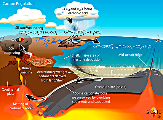
The carbonate-silicate cycle within the longer-term carbon cycle. Source: Wikimedia Commons
A group of palaeoclimatologists from China, the UK, Australia and the US have combined a variety of geochemical proxies, sedimentary records and climate modelling to correct the marine-carbonate δ18O record (Zheng, D. and 12 others 2026. Tight regulation of Earth’s long-term temperature over Phanerozoic time. Nature Communications, in press 4 May 2026; DOI: 10.1038/s41467-026-72672-6). Their approach is based on a chemical index of alteration (CIA), i.e. a measure of the degree of chemical weathering of the source for sedimentary rocks. The CIA compares their content of immobile aluminium oxide (Al2O3) with calcium, sodium and potassium oxides that are more easily moved in solution. Analyses of recent river sediments show a positive correlation between CIA and local temperature, so CIA in ancient sedimentary rocks is a potential proxy for the ambient temperature of the region from which those sediments were derived. The CIA also depends on other factors, such as the intensity of physical erosion and transport. However, allowing for these factors in modern environments does not affect the correlation with ambient temperature: the method remains robust. The geochemical data from sedimentary rocks required to use CIA as an independent check on O-isotope derived temperature are available in abundance from all continents for most of the Phanerozoic.
The study by Zheng et al. suggests that throughout the Phanerozoic global mean temperature remained consistently within the 10 to 30°C range. Thus Palaeozoic ocean temperatures were comparable with those of the succeeding Mesozoic and Cenozoic Eras. The team concludes that various negative feedback processes inherent in the Earth System have been able to regulate its surface temperature through the Phanerozoic. The most important of these is climate-dependent silicate weathering in which acidic rain – produced by CO2 dissolved from the atmosphere – breaks down silicates to yield dissolved bicarbonate ions that combine with calcium and magnesium ions to precipitate carbonates. Such a process draws down the main greenhouse gas from the atmosphere. There are other aspects of the carbon cycle that also draw down atmospheric CO2 and reduce the greenhouse effect, such as burial of organic debris. Tectonics also shapes climate by modulating both silicate weathering and CO2 emissions from volcanic activity.
It should be emphasised that anthropogenic global warming is proceeding at a far higher rate than natural negative feedback processes. We simply cannot rely on silicate weathering to reverse whatever climatic outcome results from what the current global economy does so very quickly. Yet the findings by Zheng et al. do seem likely to force a change in thinking about climate change on a geological timescale.
The Cryogenian Period that lasted from 860 to 635 million years ago is aptly named, for it encompassed two maybe three episodes of glaciation. Each left a mark on every modern continent and extended from the poles to the Equator. In some way, this series of long, frigid catastrophes seems to have been instrumental in a decisive change in Earth’s biology that emerged as fossils during the following Ediacaran Period (635 to 541 Ma). That saw the sudden appearance of multicelled organisms whose macrofossil remains – enigmatic bag-like, quilted and ribbed animals – are found in sedimentary rocks in Australia, eastern Canada and NW Europe. Their type locality is in the Ediacara Hills of South Australia, and there can be little doubt that they were the ultimate ancestors of all succeeding animal phyla. Indeed one of them Helminthoidichnites, a stubby worm-like animal, is a candidate for the first bilaterian animal and thus our own ultimate ancestor. Using the index for Palaeobiology or the Search Earth-logs pane you can discover more about them in 12 posts from 2006 to 2023. The issue here concerns the question: Why did Snowball Earth conditions develop? Again, refresh your knowledge of them, if you wish, using the index for Palaeoclimatology or Search Earth-logs. From 2000 onwards you will find 18 posts: the most for any specific topic covered by Earth-logs. The most recent are Kicking-off planetary Snowball conditions (August 2020) and Signs of Milankovich Effect during Snowball Earth episodes (July 2021): see also: Chapter 17 in Stepping Stones.
One reason why Snowball Earths are so enigmatic is that CO2 concentrations in the Neoproterozoic atmospheric were far higher than they are at present. In fact since the Hadean Earth has largely been prevented from being perpetually frozen over by a powerful atmospheric greenhouse effect. Four Ga ago solar heating was about 70 % less intense than today, because of the ‘Faint Young Sun’ paradox. There was a long episode of glaciation (from 2.5 to 2.2 Ga) at the start of the Palaeoproterozoic Era during which the Great Oxygenation Event (GOE) occurred once photosynthesis by oxygenic bacteria became far more common than those that produced methane. This resulted in wholesale oxidation to carbon dioxide of atmospheric methane whose loss drove down the early greenhouse effect – perhaps a narrow escape from the fate of Venus. There followed the ‘boring billion years’ of the Mesoproterozoic during which tectonic processes seem to have been less active. in that geologically tedious episode important proxies (carbon and sulfur isotopes) that relate to the surface part of the Earth System ‘flat-lined’. The plethora of research centred on the Cryogenian glacial events seems to have stemmed from the by-then greater complexity of the Precambrian Earth System.
Since the GOE the main drivers of Earth’s climate have been the emission of CO2 and SO2 by volcanism, the sedimentary burial of carbonates and organic carbon in the deep oceans, and weathering. Volcanism in the context of climate is a two-edged sword: CO2 emission results in greenhouse warming, and SO2 that enters the stratosphere helps reflect solar radiation away leading to cooling. Silicate minerals in rocks are attacked by hydrogen ions (H+) produced by the solution of CO2 in rain water to form a weak acid (H2CO3: carbonic acid). A very simple example of such chemical weathering is the breakdown of calcium silicate:
CaSiO3 + 2CO2 + 3H2O = Ca2+ + 2HCO3– + H4SiO4
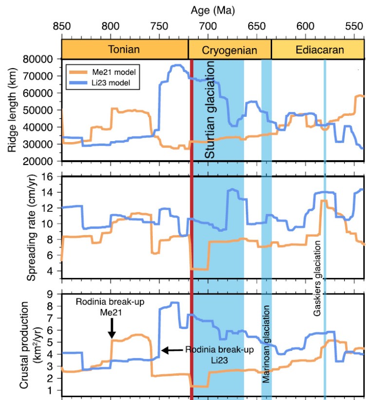
The reaction results in calcium and bicarbonate ions being dissolved in water, eventually to enter the oceans where they are recombined in the shells of planktonic organisms as calcium carbonate. On death, their shells sink and end up in ocean-floor sediments along with unoxidised organic carbon compounds. The net result of this part of the carbon cycle is reduction in atmospheric CO2 and a decreased greenhouse effect: increased silicate weathering cools down the climate. Overall, internal processes – particularly volcanism – and surface processes – weathering and carbonate burial – interact. During the ‘boring billion’ they seem to have been in balance. The two processes lie at the core of attempts to model global climate behaviour in the past, along with what is known about developments in plate tectonics – continental break-up, seafloor spreading and orogenies – and large igneous events resulting from mantle plumes. A group of geoscientists from the Universities of Sydney and Adelaide, Australia have evaluated the tectonic factors that may have contributed to the first and longest Snowball Earth of the Neoproterozoic: the Sturtian glaciation (717 to 661 Ma) (Dutkiewicz, A. et al. 2024. Duration of Sturtian “Snowball Earth” glaciation linked to exceptionally low mid-ocean ridge outgassing. Geology, v. 52, online early publication; DOI: 10.1130/G51669.1).
Palaeogeographic reconstructions (Robinson projection) during the early part of the Sturtian global glaciation: LEFT based on geological data from Neoproterozoic terrains on modern continents; RIGHT based on palaeomagnetic pole positions from those terrains. Acronyms refer to each terrains, e.g. Am is Amazonia, WAC is the West African Craton. Orange lines are ocean ridges, those with teeth are subduction zone. (Credit: Dutkiewicz et al., parts of Fig. 1)
Shortly before the Sturtian began there was a major flood volcanism event, forming the Franklin large igneous province, remains of which are in Arctic Canada. The Franklin LIP is a subject of interest for triggering the Sturtian, by way of a ‘volcanic winter’ effect from SO2 emissions or as a sink for CO2 through its weathering. But both can be ruled out as no subsequent LIP is associated with global cooling and the later, equally intense Marinoan global glaciation (655 to 632 Ma) was bereft of a preceding LIP. Moreover, a world of growing frigidity probably could not sustain the degree of chemical weathering to launch a massive depletion in atmospheric CO2. In search of an alternative, Adriana Dutkiewicz and colleagues turned to the plate movements of the early Neoproterozoic. Since 2020 there have been two notable developments in modelling global tectonics of that time, which was dominated by the evolution of the Rodinia supercontinent. One is based largely on geological data from the surviving remnants of Rodinia (download animation), the other uses palaeomagnetic pole positions to fix their relative positions: the results are very different (download animation).
Variations in ocean ridge lengths, spreading rates and oceanic crust production during the Neoproterozoic estimated from the geological (orange) and palaeomagnetic (blue) models. Credit: Dutkiewicz et al., parts of Fig. 2)
The geology-based model has Rodinia beginning to break up around 800 Ma ago with a lengthening of global constructive plate margins during disassembly. The resulting continental drift involved an increase in the rate of oceanic crust formation from 3.5 to 5.0 km2 yr-1. Around 760 Ma new crust production more than halved and continued at a much slowed rate throughout the Cryogenian and the early part of the Ediacaran Period. The palaeomagnetic model delays breakup of the Rodinia supercontinent until 750 Ma, and instead of the rate of crust production declining through the Cryogenian it more than doubles and remains higher than in the geological model until the late Ediacaran. The production of new oceanic crust is likely to govern the rate at which CO2 is out-gassed from the mantle to the atmosphere. The geology-based model suggests that from 750 to 580 Ma annual CO2 additions could have been significantly below what occurred during the Pleistocene ice ages since 2.5 Ma ago. Taking into account the lower solar heat emission, such a drop is a plausible explanation for the recurrent Snowball Earths of the Neoproterozoic. On the other hand, the model based on palaeomagnetic data suggests significant warming during the Cryogenian contrary to a mass of geological evidence for the opposite.
A prolonged decrease in tectonic activity thus seems to be a plausible trigger for global glaciation. Moreover, reconstruction of Precambrian global tectonics using available palaeomagnetic data seems to be flawed, perhaps fatally. One may ask, given the trends in tectonic data: How did the Earth repeatedly emerge from Snowball episodes? The authors suggest that the slowing or shut-down of silicate weathering during glaciations allowed atmospheric CO2 to gradually build up as a result of on-land volcanism associated with subduction zones that are a quintessential part of any tectonic scenario.
This kind of explanation for recovery of a planet and its biosphere locked in glaciation is in fact not new. From the outset of the Snowball Earth hypothesis much the same escape mechanisms were speculated and endlessly discussed. Adriana Dutkiewicz and colleagues have fleshed out such ideas quite nicely, stressing a central role for tectonics. But the glaring disparities between the two models show that geoscientists remain ‘not quite there’. For one thing, carbon isotope data from the Cryogenian and Ediacaran Periods went haywire: living processes almost certainly played a major role in the Neoproterozoic climatic dialectic.
Enormous events occurred between 460 and 435 Ma around the mid-point of the Palaeozoic Era and spanning the Ordovician-Silurian (O-S) boundary. At around 443 Ma the second-most severe mass extinction in Earth’s history occurred, which eliminated 50 to 60% of all marine genera and almost 85% of species: not much less than the Great Dying at the end of the Permian Period. The event was accompanied by one of the greatest biological diversifications known to palaeontology, which largely replaced the global biota initiated by the Cambrian Explosion. Centred on the Saharan region of northern Africa, Late Ordovician glacial deposits also occur in western South America and North America. At that time all the current southern continents and India were assembled in the Gondwana supercontinent, with continental masses that became North America, the Baltic region, Siberia and South China not far off: all the components that eventually collided to form Pangaea from the Late Silurian to the Carboniferous.
The mass extinction has troubled geologists for quite a while. There are few signs of major volcanism having been involved, although some geochemists have suggested that very high mercury concentrations in some Late Ordovician marine sediments bear witness to large, albeit invisible, igneous events. No large impact crater is known from those times, although there is a curious superabundance of extraterrestrial debris, including high helium-3, chromium and iridium concentrations, preserved in earlier Ordovician sedimentary rocks, around the Baltic Sea. Another suggestion, poorly supported by evidence, is destruction of the atmospheric ozone layer by a gamma-ray burst from some distant but stupendous supernova. A better supported idea is that the oceans around the time of the event lacked oxygen. Such anoxia can encourage solution of toxic metals and hydrogen sulfide gas. Unlike other mass extinctions, this one was long-drawn out with several pulses.
The glacial epoch also seems implicated somehow in the mass die-off, being the only one known to coincide with a mass extinction. It included spells of frigidity that exceeded those of the last Pleistocene glacial maximum, with the main ice cap having a volume of from 50 to 250 million cubic kilometres. The greatest of these, around 445 Ma, involved a 5°C fall in global sea-surface temperatures and a large negative spike in δ13C in carbon-rich sediments, both of which lasted for about a million years. The complex events around that time coincided with the highest ever extinction and speciation rates, the number of marine species being halved in a short space of time: a possible explanation for the δ13 C anomaly. Yet estimates of atmospheric CO2 concentration in the Late Ordovician suggests it was perhaps 8–16 times higher than today; Earth should have been a warm planet then. One probable contributor to extreme glacial conditions has been suggested to be that the South Pole at that time was well within Gondwana and thus isolated from the warming effect of the ocean. So, severe glaciation and a paradoxical combination of mass extinction with considerable biological diversification present quite an enigma.
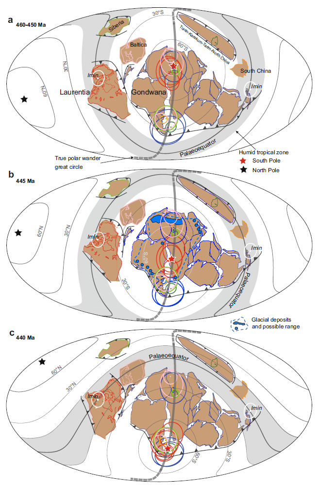
A group of scientists based in Beijing, China set out to check the palaeogeographic position of South China between 460 and 435 Ma and evaluate those in O-S sediments at locations on 6 present continents (Jing, X., Yang, Z., Mitchell, R.N. et al. 2022. Ordovician–Silurian true polar wander as a mechanism for severe glaciation and mass extinction. Nature Communications, v. 13, article 7941; DOI: 10.1038/s41467-022-35609-3). Their key tool is determining the position of the magnetic poles present at various times in the past from core samples drilled at different levels in these sedimentary sequences. The team aimed to test a hypothesis that in O-S times not only the entire lithosphere but the entire mantle moved relative to the Earth’s axis of rotation, the ‘slippage’ probably being at the Core-mantle boundary [thanks to Steve Rozario for pointing this out]. Such a ‘true polar wander’ spanning 20° over a mere 2 Ma has been detected during the Cretaceous, another case of a 90° shift over 15 Ma may have occurred at the time when Snowball Earth conditions first appeared in the Neoproterozoic around the time when the Rodinia supercontinent broke up and a similar event was proposed in 1994 for C-O times albeit based on sparse and roughly dated palaeomagnetic pole positions.
Xianqing Jing and colleagues report a wholesale 50° rotation of the lithosphere between 450 and 440 Ma that would have involved speeds of about 55 cm per year. It involved the Gondwana supercontinent and other continental masses still isolated from it moving synchronously in the same direction, as shown in the figure. From 460 to 450 Ma the geographic South Pole lay at the centre of the present Sahara. At 445 Ma its position had shifted to central Gondwana during the glacial period. By 440 Gondwana had moved further northwards so that the South Pole then lay at Gondwana’s southernmost extremity.
Palaeogeographic reconstructions charting true polar wander and the synchronised movement of all continental masses between 460 and 440 Ma. Note the changes in the trajectories of lines of latitude on the Mollweide projections. The grey band either side of the palaeo-Equator marks intense chemical weathering in the humid tropics. Credit Jing et al. Fig 5.
As well as a possible key to the brief but extreme glacial episode this astonishing journey by a vast area of lithosphere may help account for the mass extinction with rapid speciation and diversification associated with the O-S boundary. While the South Pole was traversing Gondwana as the supercontinent shifted the ‘satellite’ continental masses remained in or close to the humid tropics, exposed to silicate weathering and erosion. That is a means for extracting CO2 from the atmosphere and launching global cooling, eventually to result in glaciation over a huge tract of Gondwana around 445 Ma. Gondwana then moved rapidly into more clement climatic zones and was deglaciated a few million years later. The rapid movement of the most faunally diverse continental-shelf seas through different climate zones would have condemned earlier species to extinction simultaneous adaptation to changed conditions could have encouraged the appearance of new species and ecosystems. This does not require the catastrophic mechanisms largely established for the other mass extinction events. It seems that during the stupendous, en masse slippage of the Earth’s lithosphere plate tectonic processes still continued, yet it must have had a dynamic effect throughout the underlying mantle.
Yet the fascinating story does have a weak point. What if the position of the magnetic poles shifted during O-S times from their assumed rough coincidence with the geographic poles? In other words, did the self-exciting dynamo in the liquid outer core undergo a large and lengthy wobble? How the outer core’s circulation behaves depends on its depth to the solid core, yet the inner core seems only to have begun solidifying just before the onset of the Cambrian, about 100 Ma before the O-S events. It grew rapidly during the Palaeozoic, so the thickness of the outer core was continuously increasing. Fluid dynamic suggests that the form of its circulation may also have undergone changes, thereby affecting the shape and position of the geomagnetic field: perhaps even shifting its poles away from the geographic poles …


