Enormous events occurred between 460 and 435 Ma around the mid-point of the Palaeozoic Era and spanning the Ordovician-Silurian (O-S) boundary. At around 443 Ma the second-most severe mass extinction in Earth’s history occurred, which eliminated 50 to 60% of all marine genera and almost 85% of species: not much less than the Great Dying at the end of the Permian Period. The event was accompanied by one of the greatest biological diversifications known to palaeontology, which largely replaced the global biota initiated by the Cambrian Explosion. Centred on the Saharan region of northern Africa, Late Ordovician glacial deposits also occur in western South America and North America. At that time all the current southern continents and India were assembled in the Gondwana supercontinent, with continental masses that became North America, the Baltic region, Siberia and South China not far off: all the components that eventually collided to form Pangaea from the Late Silurian to the Carboniferous.
The mass extinction has troubled geologists for quite a while. There are few signs of major volcanism having been involved, although some geochemists have suggested that very high mercury concentrations in some Late Ordovician marine sediments bear witness to large, albeit invisible, igneous events. No large impact crater is known from those times, although there is a curious superabundance of extraterrestrial debris, including high helium-3, chromium and iridium concentrations, preserved in earlier Ordovician sedimentary rocks, around the Baltic Sea. Another suggestion, poorly supported by evidence, is destruction of the atmospheric ozone layer by a gamma-ray burst from some distant but stupendous supernova. A better supported idea is that the oceans around the time of the event lacked oxygen. Such anoxia can encourage solution of toxic metals and hydrogen sulfide gas. Unlike other mass extinctions, this one was long-drawn out with several pulses.
The glacial epoch also seems implicated somehow in the mass die-off, being the only one known to coincide with a mass extinction. It included spells of frigidity that exceeded those of the last Pleistocene glacial maximum, with the main ice cap having a volume of from 50 to 250 million cubic kilometres. The greatest of these, around 445 Ma, involved a 5°C fall in global sea-surface temperatures and a large negative spike in δ13C in carbon-rich sediments, both of which lasted for about a million years. The complex events around that time coincided with the highest ever extinction and speciation rates, the number of marine species being halved in a short space of time: a possible explanation for the δ13 C anomaly. Yet estimates of atmospheric CO2 concentration in the Late Ordovician suggests it was perhaps 8–16 times higher than today; Earth should have been a warm planet then. One probable contributor to extreme glacial conditions has been suggested to be that the South Pole at that time was well within Gondwana and thus isolated from the warming effect of the ocean. So, severe glaciation and a paradoxical combination of mass extinction with considerable biological diversification present quite an enigma.
A group of scientists based in Beijing, China set out to check the palaeogeographic position of South China between 460 and 435 Ma and evaluate those in O-S sediments at locations on 6 present continents (Jing, X., Yang, Z., Mitchell, R.N. et al. 2022. Ordovician–Silurian true polar wander as a mechanism for severe glaciation and mass extinction. Nature Communications, v. 13, article 7941; DOI: 10.1038/s41467-022-35609-3). Their key tool is determining the position of the magnetic poles present at various times in the past from core samples drilled at different levels in these sedimentary sequences. The team aimed to test a hypothesis that in O-S times not only the entire lithosphere but the entire mantle moved relative to the Earth’s axis of rotation, the ‘slippage’ probably being at the Core-mantle boundary [thanks to Steve Rozario for pointing this out]. Such a ‘true polar wander’ spanning 20° over a mere 2 Ma has been detected during the Cretaceous, another case of a 90° shift over 15 Ma may have occurred at the time when Snowball Earth conditions first appeared in the Neoproterozoic around the time when the Rodinia supercontinent broke up and a similar event was proposed in 1994 for C-O times albeit based on sparse and roughly dated palaeomagnetic pole positions.
Xianqing Jing and colleagues report a wholesale 50° rotation of the lithosphere between 450 and 440 Ma that would have involved speeds of about 55 cm per year. It involved the Gondwana supercontinent and other continental masses still isolated from it moving synchronously in the same direction, as shown in the figure. From 460 to 450 Ma the geographic South Pole lay at the centre of the present Sahara. At 445 Ma its position had shifted to central Gondwana during the glacial period. By 440 Gondwana had moved further northwards so that the South Pole then lay at Gondwana’s southernmost extremity.
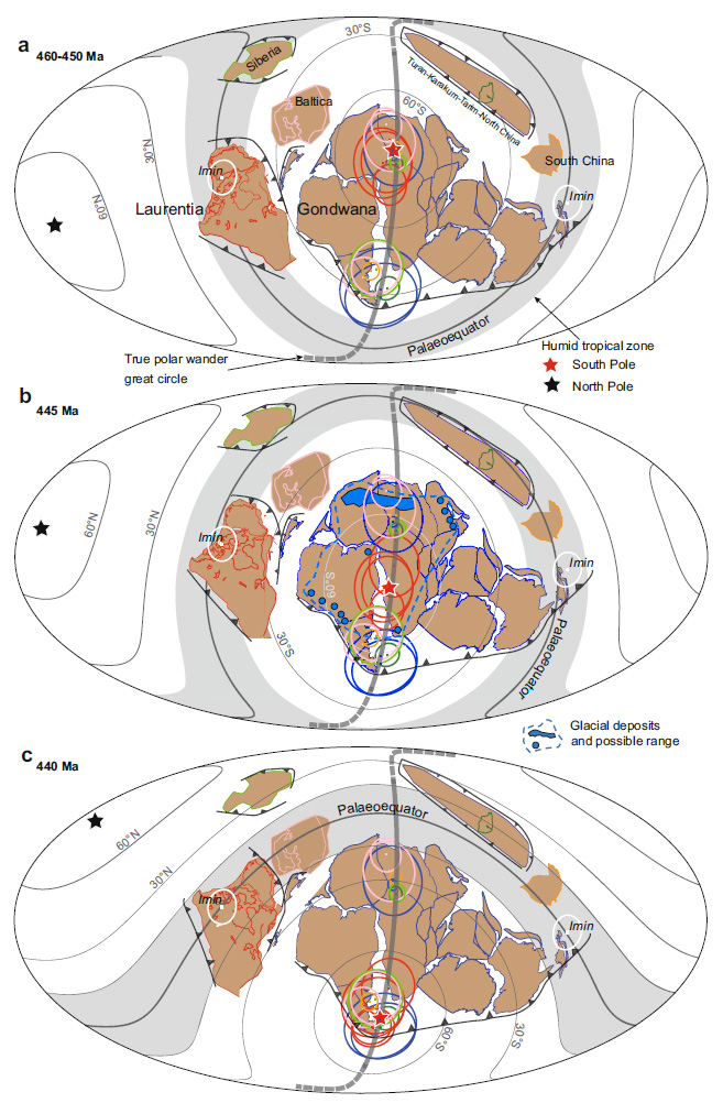
As well as a possible key to the brief but extreme glacial episode this astonishing journey by a vast area of lithosphere may help account for the mass extinction with rapid speciation and diversification associated with the O-S boundary. While the South Pole was traversing Gondwana as the supercontinent shifted the ‘satellite’ continental masses remained in or close to the humid tropics, exposed to silicate weathering and erosion. That is a means for extracting CO2 from the atmosphere and launching global cooling, eventually to result in glaciation over a huge tract of Gondwana around 445 Ma. Gondwana then moved rapidly into more clement climatic zones and was deglaciated a few million years later. The rapid movement of the most faunally diverse continental-shelf seas through different climate zones would have condemned earlier species to extinction simultaneous adaptation to changed conditions could have encouraged the appearance of new species and ecosystems. This does not require the catastrophic mechanisms largely established for the other mass extinction events. It seems that during the stupendous, en masse slippage of the Earth’s lithosphere plate tectonic processes still continued, yet it must have had a dynamic effect throughout the underlying mantle.
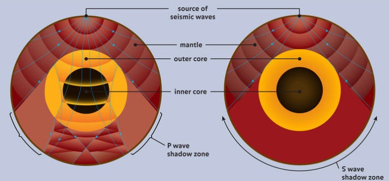
Yet the fascinating story does have a weak point. What if the position of the magnetic poles shifted during O-S times from their assumed rough coincidence with the geographic poles? In other words, did the self-exciting dynamo in the liquid outer core undergo a large and lengthy wobble? How the outer core’s circulation behaves depends on its depth to the solid core, yet the inner core seems only to have begun solidifying just before the onset of the Cambrian, about 100 Ma before the O-S events. It grew rapidly during the Palaeozoic, so the thickness of the outer core was continuously increasing. Fluid dynamic suggests that the form of its circulation may also have undergone changes, thereby affecting the shape and position of the geomagnetic field: perhaps even shifting its poles away from the geographic poles …