New drill core penetrates the Mohorovičić Discontinuity (the ‘Moho’)

In 1909 Croatian geophysicist Andrija Mohorovičić examined seismograms of a shallow earthquake that shook the area around Zagreb. To his surprise the by-then familiar time sequence of P-waves followed by the slower S-waves appeared twice on seismic records up to 800 km away. The only explanation that he could come up with was that the first arrivals had travelled directly through the crust to the detector whereas the second set must have followed a longer path: it had travelled downwards to be refracted to reach the surface when it met rocks denser than those at the surface. His analysis revealed a sharp boundary between the Earth’s crust and its mantle at a depth of about 54 km below what was then Yugoslavia. Later workers confirmed this discovery and honoured its discoverer by naming it the Mohorovičić Discontinuity. Difficulty with pronouncing his name resulted in a geological nickname: ‘the Moho’. It can be detected everywhere: at 20 to 90 km beneath the continental surface and 5 to 10 km beneath the ocean floor, thus distinguishing between continental and oceanic crust.

In the late 1950s accelerating geological and oceanographic research that would culminate in the theory of plate tectonics turned its focus on drilling down to the Moho in much the same way as a lust for space travel spawned getting to the Moon. The difference was that the proposers of what became known as the Mohole Project were members of what amounted to a geoscientific glee club (The American Miscellaneous Society), which included a member of the well-financed US National Science Foundation’s Earth Science Panel. The idea emerged shortly after the Soviet Union had launched the Sputnik satellite and rumours emerged that it was proposing deep drilling into the continental crust beneath the Kola Peninsula.  The Mohole’s initial target was the 3.9 km deep floor of the Caribbean off Guadalupe in Mexico and required advanced methods of stabilisation for a new oceanographic ship that was to host the drilling rig.

Huge (tens of metres high) pillars or ‘chimneys’ of carbonates formed by the Lost City hydrothermal vent near the mid-Atlantic ridge (Credit: ETH Zurich)

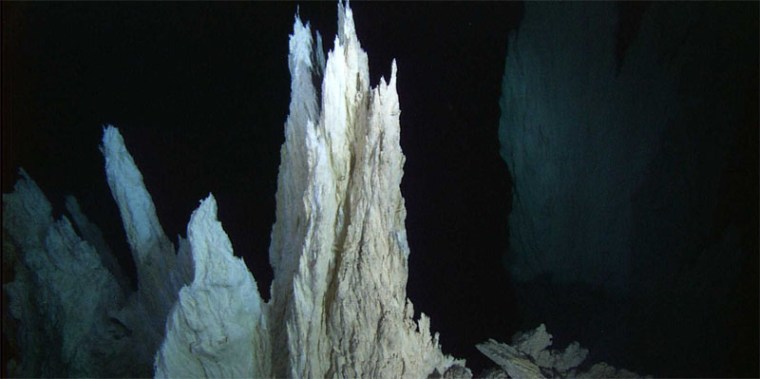
The Mohole was spudded in 1961, but the deepest of five holes reached only 200 m beneath the sea floor. It recovered Miocene sediments and a few metres of basalt. Deep water drilling was somewhat more complicated than expected and about US$ 57 million was spent fruitlessly. The project was disbanded in 1966 with considerable acrimony and schadenfreude. Nonetheless, the Mohole fiasco made technical advances and did demonstrate the feasibility of offshore drilling. The petroleum industry benefitted and so did oceanography with the globe-spanning deep-sea drilling of ocean floor sediments. The sediment cores produced the 200 million-year exquisitely detailed record of climate change and vast amounts of geochemical data from the basaltic oceanic crust. In 2005 JOIDES (the Joint Oceanographic Institutions for Deep Earth Sampling) had another crack at the Moho. That venture centred on the intersection of the Mid-Atlantic Ridge and the Atlantis Fracture Zone close to the ‘Lost City’ hydrothermal vent. The area around the vent is the site of a huge low-angled extensional fault that has partly dragged the basaltic ocean crust off the mantle beneath causing it to bulge. This provided an excellent opportunity to drill through the Moho. All went well, but 54 days of drilling yielded 1.4 km of basalt but nothing resembling mantle rock. So, again, the Moho had thwarted Science (and research economics). But finally it is beginning to reveal it secrets (see: Voosen, P. 2023. Ocean drillers exhume a bounty of mantle rocks. Science, v. 380 (News) p. 876-877; DOI: 10.1126/science.adi9899

The area around the ‘Lost City’ vent was originally chosen for drilling to examine the chemical processes going on there. Hydrogen emitted by serpentinisation of mantle rocks can combine with carbon monoxide in hydrothermal fluids to create a wide variety of organic compounds, which could be the initial building blocks for the origin of life. As part of the International Ocean Drilling Programme JOIDES decided to launch IODP Expedition 399 to re-examine the area around ‘Lost City’ in more detail. The expedition first tried to continue drilling the 2005 hole, but failed yet again. Finally a new drill site aimed at penetrating the extensional detachment. Within a few days the drill bit punched into mantle rocks and over a 6-week period the expedition had recovered a kilometre of core. The technical accounts for each week of drilling give a flavour of what it must be like to be a part of such a ship-borne expedition as well as describing what emerged in the drill core. It seems like a bit of a jumble, dominated by the mineral olivine– the principal characteristic of the ultramafic mantle – almost pure in the rock dunite and mixed with pyroxenes in various kinds of peridotite. There are also coarse-grained rocks that contain plagioclase feldspar, which cut through the ultramafic materials – gabbros, troctolites and norites.  They are relics of intrusive basaltic magmas that did not make it to the seabed. The samples are variably altered by interaction with watery hydrothermal fluids, with lots of serpentine, talc and even asbestos: the drilling presented a health hazard for a few days. The rocks have been metamorphosed under pressure-temperature conditions of greenschist to amphibolite facies and subject to ductile deformation, probably because of the effect of extensional deformation. Whatever, there is plenty of material to be analysed, including for signs of microbial activity. So, the dreams of a 1950s academic drinking fraternity (they were all men!) have finally been realised. But since those pre-plate-tectonic times many geologists have seen and collected much the same, even putting their index fingers on the Moho itself in the time-honoured fashion. Intricate 3-D geology in ophiolite complexes such as that in Oman, provide such opportunities at the much lower cost of air travel, Land Cruiser hire and camping. Indeed what we know of the structure of the oceanic lithosphere – pillow lavas, sheeted dyke complexes, gabbro cumulates and serpentinised ultramafic mantle – has come from such bodies thrust onto continental crust at ancient plate margins. So, why the celebration in this case? They are the first samples of mantle from young oceanic lithosphere; the rocks of ophiolites may not have formed at mid-ocean ridges. These should give clues to the long-term magmatism that has created the vast abyssal basins that the mantle eventually reabsorbs by subduction. Then, of course, there is the link to biogenic processes at constructive margins that underpinned the return to the active hydrothermal venting at ‘Lost City’.

Two happy events for plate tectonics

In an era where fears of rising sea level and loss of land are growing it is a great pleasure to announce (albeit several years late) the birth of two new islands. They emerged close to the axis of the Red Sea in Yemeni territory as new members of the volcanic Zubair Islands during episodic eruptions that began on 18 December 2011. First to form was dubbed Sholan (‘One who is Blessed’ in Arabic – a girl’s name), which ceased to be active a month later. Further submarine volcanism began on 28 September 2013, with another island, Jadid (‘New’ in Arabic – a boy’s name), breaking surface in October 2013. The double event has been described in great detail by geoscientists based at King Abdullah University of Science and Technology, Saudi Arabia (Xu, W. 2015. Birth of two volcanic islands in the southern Red Sea. Nature Communications, DOI: 10.1038/ncomms8104. After rapid growth during their initial eruptive phases both islands underwent significant marine erosion once quiescent, but seem set to remain as part of the Zubair archipelago.

'Before and after' images of the Zubair archipelago in the southern Red Sea. (Left from Bing maps, right (February 2014) from Google Earth)
‘Before and after’ images of the Zubair archipelago in the southern Red Sea. (Left from Bing maps, right (February 2014) from Google Earth)

Analysis of small earthquakes that happened during the islands’ growth together with Interferometric iradar surveys that showed coincident ground movements among the islands suggest that both eruptions took place along an active north-south fracture system, probably part of axial rifting system of the Red Sea. In more detail, magma seems to have moved upwards along N-S fissures similar to those that now show up as dykes cutting lavas on the older islands in the area. The local fracture patterns are oblique to the main Red Sea Rift that trends NNW-SSE, possibly as a result of non-linear stress trajectories in the Arabia-Africa rifting. In almost all respects the volcanism and mechanism of intrusion and effusion closely resemble that reported recently from a terrestrial setting in the nearby Afar Depression. The slow spreading Red Sea Rift rarely manifests itself by volcanism, so these events reveal a previous unsuspected zone of active melting in the mantle beneath the Zubair archipelago.

Glacial cycles and sea-floor spreading

The London Review of Books recently published a lengthy review (Godfrey-Smith, P. 2015. The Ant and the Steam Engine. London Review of Books, v. 37, 19 February 2015 issue, p. 18-20) of the latest contribution to Earth System Science by James Lovelock, the man who almost singlehandedly created that popular paradigm through his Gaia concept of a self-regulating Earth (Lovelock, J. A Rough Ride to the Future. Allen Lane: London; ISBN 978 0 241 00476 0). Coincidentally, on 5 February 2015 Science published online a startling account of the inner-outer-inner synergism of Earth processes and climate (Crowley, J.W. et al. 2015. Glacial cycles drive variations in the production of oceanic crust. Science doi:10.1126/science.1261508). In fact serendipity struck twice: the following day a similar online article appeared in a leading geophysics journal (Tolstoy, M. 2015. Mid-ocean ridge eruptions as a climate valve. Geophysical Research Letters, doi:10.1002/2014GL063015)

Both articles centred on the most common topographic features on the ocean floor, abyssal hills. These linear features trend parallel to seafloor spreading centres and the magnetic stripes, which chart the progressive additions to oceanic lithosphere at constructive margins. Abyssal hills are most common around intermediate- and fast-spreading ridges and have been widely regarded as fault-tilt blocks resulting from extensional forces where cooling of the lithosphere causes it to sag towards the abyssal plains. However, some have suggested a possible link with variations in magma production beneath ridge axes as pressure due to seawater depth varied with rising and falling sea level through repeated glacial cycles. Mantle melting beneath ridges results from depressurization of rising asthenosphere: so-called ‘adiabatic’ melting. Pressure changes equivalent to sea-level fluctuations of around 100-130 m should theoretically have an effect on magma productivity, falls resulting in additional volumes of lava erupted on the ocean floor and thus bathymetric highs.

English: A close-up showing mid-ocean ridge to...
Formation of mid-ocean ridge topography, including abyssal hills that parallel the ridge axis. (credit: Wikipedia)

A test of this hypothesis would be see how the elevation of the sea floor adjacent to spreading axes changes with the age of the underlying crust. John Crowley and colleagues from Oxford and Harvard Universities and the Korea Polar Research Institute analysed new bathymetry across the Australian-Antarctic Ridge, whereas Maya Tolstoy of Columbia University performed similar work across the Southern East Pacific Rise. In both studies frequency analysis of changes in bathymetry through time, as calibrated by local magnetic stripes, showed significant peaks at roughly 23, 41 and 100 ka in the first study and at 100 ka in the second. These correspond to the well known Milankovitch periods due to precession, changing axial tilt and orbital eccentricity: persuasive support for a glacial control over mid-ocean ridge magmatism.

Enlarged by 100% & sharpened file with IrfanView.
Periodicities of astronomical forcing and global climate over the last million years (credit: Wikipedia)

An interesting corollary of the observations may be that pulses in sea-floor eruption rates emit additional carbon dioxide, which eventually percolates through the ocean to add to its atmospheric concentration, which would result in climatic warming. The maximum effect would correspond to glacial maxima when sea level reached its lowest, the reduction in pressure stimulating the greatest magmatism. One of the puzzling features of glacial cycles over the last million years, when the 100 ka eccentricity signal dominates, is the marked asymmetry of the sea-level record; slowly declining to a glacial maximum and then a rapid rise due to warming and melting as the Earth changed to interglacial conditions. Atmospheric CO2 concentrations recorded by bubbles in polar ice cores show a close correlation with sea-level change indicated by oxygen isotope data from oceanic sediments. So it is possible that build-up of polar ice caps in a roundabout way eventually reverse cooling once they reach their greatest thickness and extents, by modulating ocean-ridge volcanism and thereby the greenhouse effect.