Tectonics and glacial epochs

Because the configuration of continents inevitably affects the ocean currents that dominate the distribution of heat across the face of the Earth, tectonics has a major influence over climate. So too does the topography of continents, which deflects global wind patterns, and that is also a reflection of tectonic events. For instance, a gap between North and South America allowed exchange of the waters of the Pacific and Atlantic Oceans throughout the Cenozoic Era until about 3 Ma ago, at the end of the Pliocene Epoch, although the seaway had long been shallowing as a result of tectonics and volcanism at the destructive margin of the eastern Pacific. That seemingly minor closure transformed the system of currents in the Atlantic Ocean, particularly the Gulf Stream, whose waxing and waning were instrumental in the glacial-interglacial cycles that have persisted for the last 2.5 Ma. This was partly through its northward transport of saltier water formed by tropical evaporation that cooling at high northern latitudes encouraged to sink to form a major component of the global oceanic heat conveyor system.   Another example is the rise of the Himalaya following India’s collision with Eurasia that gave rise to the monsoonal system  dominating the climate of southern Asia. The four huge climatic shifts to all-pervasive ice-house conditions during the Phanerozoic Eon are not explained so simply: one during the late-Ordovician; another in the late-Devonian; a 150 Ma-long glacial epoch spanning much of the Carboniferous and Permian Periods, and the current Ice Age that has lasted since around 34 Ma. Despite having been at the South Pole since the Cretaceous Antarctica didn’t develop glaciers until 34 Ma. So what may have triggered these four major shifts in global climate?

Five palaeoclimatologists from the University of California and MIT set out to find links, starting with the most basic parameter, how atmospheric greenhouse gases might have varied. In the long term CO2 builds up through its emission by volcanoes. It is drawn down by several geological processes: burial of carbon and carbonates formed by living processes; chemical weathering of silicate minerals by CO2 dissolved in water, which forms solid calcium carbonate in soil and carbonate ions in seawater that can be taken up and buried by shell-producing organisms. Rather than comparing gross climate change with periods of orogeny and mountain building, mainly due to continent-continent collisions, they focused on zones that preserve signs of subduction of oceanic lithosphere – suture zones (Macdonald,F.A. et al. 2019. Arc-continent collisions in the tropics set Earth’s climate state. Science, v. 363 (in press); DOI: 10.1126/science.aav5300 ). Comparing the length of all sutures active at different times in the Phanerozoic with the extent of continental ice sheets there is some correlation between active subduction and glaciations, but some major misfits. Selecting only sutures that were active in the tropics of the time – the zone of most intense chemical weathering – results in a far better tectonic-climate connection. Their explanation for this is not tropical weathering of all kinds of exposed rock but of calcium- and magnesium-rich igneous rocks; basaltic and ultramafic rocks. These dominate oceanic lithosphere, which is exposed to weathering mainly where slabs of lithosphere are forced, or obducted, onto continental crust at convergent plate margins to form ophiolite complexes. The Ca- and Mg-rich silicates in them weather quickly to take up CO2 and form carbonates, especially in the tropics. Through such weathering reactions across millions of square kilometres the main greenhouse gas is rapidly pulled out of the atmosphere to set off global cooling.

407458aa.2
Top – variation in the total length of active, ophiolite-bearing sutures during the Phanerozoic; middle – length of such sutures in the tropics; bottom – extent of Phanerozoic glaciers. (Credit: Macdonald et al. 2019; Fig.2

Rather than the climatic influence of tectonics through global mountain building, the previous paradigm, Macdonald and colleagues show that the main factor is where subduction and ophiolite obduction were taking place. In turn, this very much depended on the configuration of continents on which ophiolites can be preserved. The most active period of tectonics during the Mesozoic, as recorded by the global length of sutures, was at 250 Ma – the beginning of the Triassic Period – but they were mainly outside the tropics, when there is no sign of contemporary glaciation. During the Ordovician, late-Devonian and Permo-Carboniferous ice-houses active sutures were most concentrated in the tropics. The same goes for the build-up to the current glacial epoch.

Read more on Palaeoclimatology and Tectonics

How does subduction start?

Robert Stern of the University of Texas at Dallas, USA, and Taras Gerya of ETH, Zurich, have produced a masterly review of how subduction gets started from place to place, and from time to time in geological history (Stern, R.J. & Gerya, T. 2018. Subduction initiation in nature and models: A review. Tectonophysics, v. 744 (in press); (PDF). It is the foundering of oceanic lithosphere into the mantle and gravity that give modern plate tectonics the bulk of energy that drives it along by slab pull. Yet the mantle’s consumption of a lithospheric slab somehow has to be set in motion from the symmetrical spreading of ocean floor as occurs either side of a constructive margin. It could not happen were the lithosphere to retain its low bulk density relative to mantle peridotite for all time. Moreover, it wouldn’t last for long were the lithosphere not to retain its strength through hundreds of kilometres depth as it sinks into the mantle. Active subduction zones have consumed vast amounts of oceanic lithosphere, for more than 65 million years, especially in fast-spreading ocean basins such as the western and eastern Pacific. The record is held by the destructive margin on the west flank of South America where more than 150 million years-worth of eastern Pacific lithosphere has been swallowed. Yet in order for oceanic lithosphere, which is stronger than that beneath the continents, somehow to fail and begin to sink a linear weak zone must develop at the interface between two incipient new plates. On top of that, all subduction on Earth is one-sided. A simple mechanism involving just thermal convection predicts that both plates either side of a break would have similar density so both should sink, more or less symmetrically.

subduction types
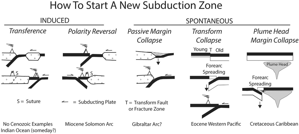
Various ways in which subduction may start. (Credit: Stern and Gerya 2018 – in press – Figure 4)

Geophysical observations reveal that terrestrial subduction can be divided into that which is induced by plate motions and changes in force balance within spreading plates, or spontaneously due to unique conditions developing along the line of initiation. In the first class are cases where a microcontinent is driven into another continental margin and extinguishes the subduction responsible, while spreading continues behind the accreted microcontinent drive older lithosphere beneath the suture (this may have happened in the past but is not seen today). Another, similar, induced case occurs where an oceanic island arc accretes by subduction beneath it so that subduction flips in polarity to consume the driving sea-floor spreading. The loading of oceanic lithosphere by sediments piled onto it by erosion of a continental margin may spontaneously collapse to result in subduction beneath the sedimentary wedge and the continent (again, not happening today, but inferred from examples inferred by earlier geological history). Spontaneous failure may also occur where old, cold lithosphere is juxtaposed with younger by transform faulting, or where a mantle plume heats up lithosphere to create a thermally weakened zone.

Stern and Gerya do not leave the issue at simple mechanics but discuss how plates may develop weak zones or inherit them from earlier tectonic events. The role of water released by metamorphism of descending materials may encourage the observed one-sidedness of subduction by reducing frictional resistance and plate strength and make the process self-sustaining. The paper also discusses the various permutations and combinations that affect the style of induced destructive margins in compressional and extensional environments and a whole variety of nuanced cases of spontaneous initiation. Numerical modelling of the subduction process plays an important, though somewhat bewildering role in discussion, as do considerations of the forces likely to be at play. Applying theoretical considerations to actual examples from the geological record are sublimely enlivening, as are speculations about the future evolution of the passive margins of the Atlantic. Clearly, there is a healthy future for field and mathematical study on the processes at destructive plate margins, such as building in the aspects of magmagenesis. Since Stern has built his career on study of long dead collusions zones, products of arc accretion etcetera, development of their understanding is undoubtedly the main thrust of his and Gerya’s tour de force. Stern provides a full PDF at his University of Texas website for the benefit of anyone who wants to delve deeper than space at Earth-pages and my limited intellect permit!

A fully revised edition of Steve Drury’s book Stepping Stones: The Making of Our Home World can now be downloaded as a free eBook

Snowball Earth: A result of global tectonic change?

The Snowball Earth hypothesis first arose when Antarctic explorer Douglas Mawson (1882-1958)speculated towards the end of his career on an episode of global glaciations, based on his recognition in South Australia of thick Neoproterozoic glacial sediments. Further discoveries on every continent, together with precise dating and palaeomagnetic indications of the latitude at which they were laid down, have steadily concretised Mawson’s musings. It is now generally accepted that frigid conditions enveloped the globe at least twice – the Sturtian (~715 to 660 Ma) and Marinoan (650 to 635 Ma) glacial episodes – and perhaps more often during the Neoproterozoic Era. Such an astonishing idea has spurred intensive studies of geochemistry associated with the events, which showed rapid variations in carbon isotopes in ancient seawater, linked to the terrestrial carbon cycle that involves both life- and Earth processes. Strontium isotopes suggest that the Neoproterozoic launched erratic variation of continental erosion and weathering and related carbon sequestration that underpinned major climate changes in the succeeding Phanerozoic Eon. Increased marine phosphorus deposition and a change in sulfur isotopes indicate substantial change in the role of oxygen in seawater. The preceding part of the Proterozoic Eon is relatively featureless in most respects and is known to some geoscientists as the ‘Boring Billion’.

Untitled-1
Artist’s impression of the glacial maximum of a Snowball Earth event (Source: NASA)

Noted tectonician Robert Stern and his colleague Nathan Miller, both of the University of Texas, USA, have produced a well- argued and -documented case (and probably cause for controversy) that suggests a fundamental change in the way the Precambrian Earth worked at the outset of the Neoproterozoic (Stern, R.J. & Miller, N.R. 2018. Did the transition to plate tectonics cause Neoproterozoic Snowball Earth. Terra Nova, v. 30, p. 87-94). To the geochemical and climatic changes they have added evidence from a host of upheavals in tectonics. Ophiolites and high-pressure, low-temperature metamorphic rocks, including those produced deep in the mantle, are direct indicators of plate tectonics and subduction. Both make their first, uncontested appearance in the Neoproterozoic. Stern and Miller ask the obvious question; Was this the start of plate tectonics? Most geologists would put this back to at least the end of the Archaean Eon (2,500 Ma) and some much earlier, hence the likelihood of some dispute with their views.

They consider the quiescent billion years (1,800 to 800 Ma) before all this upheaval to be evidence of a period of stagnant ‘lid tectonics’, despite the Rodinia supercontinent having been assembled in the latter part of the ‘Boring Billion’, although little convincing evidence has emerged to suggest it was an entity formed by plate tectonics driven by subduction. But how could the onset of subduction-driven tectonics have triggered Snowball Earth? An early explanation was that the Earth’s spin axis was much more tilted in the Neoproterozoic than it is at present (~23°). High obliquity could lead to extreme variability of seasons, particularly in the tropics. A major shift in axial tilt requires a redistribution of mass within a planetary body, leading to true polar wander, as opposed to the apparent polar wander that results from continental drift. There is evidence for such an episode around the time of Rodinia break-up at 800 Ma that others have suggested stemmed from the formation of a mantle superplume beneath the supercontinent.

Considering seventeen possible geodynamic, oceanographic and biotic causes that have been plausibly suggested for global glaciation Stern and Miller link all but one to a Neoproterozoic transition from lid- to plate tectonics. Readers may wish to examine the authors’ reasoning to make up their own minds –  their paper is available for free download as a PDF from the publishers.

A fully revised edition of Steve Drury’s book Stepping Stones: The Making of Our Home World can now be downloaded as a free eBook

Evolution of the River Nile

The longest river in the world, the Nile has all sorts of riveting connotations in terms of archaeology, Africa’s colonial history, the romance of early exploration and is currently the focus of disputes about rights to its waters. The last stems from its vast potential for irrigation and for hydropower. It is probably the most complex of all the major rivers of our planet because it stretches across so many climatic zones, topographic systems geological and tectonic provinces. Mohamed Abdelsalam of Oklahoma State University, who was born in the Sudan and began his career at the confluence of the White and Blue Nile in its capital Khartoum, is an ideal person to produce a modern scientific summary of how the Nile has evolved. That is because he has studied some of the key elements of the geology through which the river and its major tributaries travel, but most of all because he is a leading geological and geomorphological interpreter of remotely sensed data. Only space imagery can let us grasp the immense span and complexity of the Nile system. His recent review of its entirety (Abdelsalam, M.G. 2018. The Nile’s journey through space and time: A geological perspective. Earth Science Reviews, v. 177, p. 742-773; doi: 10.1016/j.earscirev.2018.01.010) is a tour de force, many years in the compilation, and it makes fittingly compulsive reading.

Abdelsalam lays out the geomorphology, underlying geology and regional tectonics of the Nile drainage basin, synthesized from publications over the last century, including his own work on the evolution of the Blue Nile in Ethiopia. On the regional scale elements of its complexity can be ascribed to the upwelling of mantle plumes beneath the Ethiopian Highlands and Red Sea, and under the Lake Plateau centred on Kenya, Tanzania, Rwanda and Burundi. These plumes are part of a much larger mantle mass rising from the core-mantle boundary beneath the African continent. Their influence on the lithosphere of north-east Africa began over 30 million years ago, producing vast outpourings of flood basalts followed by regional doming, the formation of large shield volcanoes and rifting to transform a once muted surface to one with a topographic range of up to 5 kilometres in the Nile’s two main source regions in Ethiopia and the Lakes Plateau.

Nile geology F5
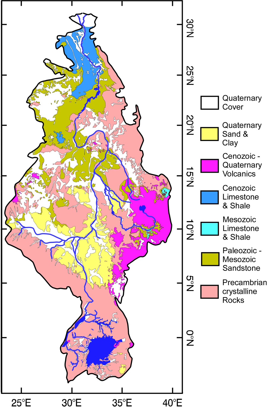
The geological underpinnings of the Nile system (Credit: Abdelsalam 2018; Fig. 5)

The basin can be divided into six distinct provinces, from south to north the Lakes, Sudd, Central Sudan, Ethiopia – East Sudan, Cataract and Egyptian Niles. Each of them has had a different history; in fact, the making of the Nile system as we know it has taken at least 6 million years and probably longer. For instance, the Lakes Nile basin, founded mostly on Precambrian crystalline basement, seems original to have drained westward through the Congo system to the Atlantic Ocean. Sometime between 20 and 12 Ma the western branch of the East African Rift System began to form along with slow, broad uplift, hindering westward flow to create the forerunners of the Great Lakes. The flow was reversed around 2.5 Ma ago by the rise of the Rwenzori and Virunga massifs on the western rift flank and eventually forced northwards into the low-lying Sudd, breaching a major divide in Northern Uganda. The vast swamps there have acted as a buffer for sediment supply, other than the finest silts and clays, into the northern stretches of the White Nile. The Blue Nile’s tortuous trajectory evolved as the Ethiopian flood basalt province rose after 30 Ma, rifted to form the Lake Tana Basin and drained to initiate erosion into the rising plateau with the interference of huge shield volcanoes that formed as uplift proceeded.

Other events are recorded along the Nile’ general trajectory by huge, abandoned alluvial fans, relics of now vanished lakes and evidence from satellite radar of palaeo-drainages with reversed flow beneath the surface of the eastern Sahara. The system evolved episodically, in five or more steps, at the whim of broad tectonic processes that affected flow direction and erosive capacity. The Cataract Nile that cuts through hard basement rocks perhaps records the increase in energy added by the Blue Nile which, which in turn may have encouraged the drainage of the huge Sudd swamps that established the White Nile’s course. Even the Mediterranean Sea played a role: the Egyptian Nile may have formed when the sea vanished to expose a deep saline basin during the Messinian Salinity Crisis 5.5 Ma ago. This reduction in the regional base level of erosion possibly directed drainage into the present course of the Nile. The various provinces only became a unified drainage system during the last half million years, and that emerged in its present form as recently as 15 thousand years ago.  But as Abdelsalam points out, there is a great deal to learn about the fabled river system. Hopefully his review will encourage others to take investigations forward and into previously unstudied regions.

Hot-spot track beneath the Greenland ice cap

Around 63 Ma ago, during the Palaeocene Epoch, major igneous activity broke out in what are now both sides of the North Atlantic Ocean. After initial sputtering it culminated massively between 57 and 53 Ma. Relics are to be seen in Baffin Island, West and East Greenland, the Faeroes and north-western parts of the British Islands, in the form of flood basalts, dyke swarms and scattered remnants of central volcanoes. Offshore drilling on the North Atlantic’s continental shelves suggests that the volcanism extended over 1.3 million km2 and blurted out around 6.6 million km3 of magma. Not for nothing have the products of this event been categorised as a Large Igneous Province. Its formation took place before the North Atlantic existed. It began to form as this precursor magmatic paroxysm waned.  Continued basaltic magma production created the ocean floor each side of the mid-Atlantic Ridge system to divide North America and Greenland from northern Europe. Sea floor spreading continues, rising above sea level in Iceland, which is underlain by a large mantle plume.

The plume beneath Iceland may have been present at a fixed position in the mantle for tens of million years. A hot spot over which plate movements have shifted lithosphere to be heated in a similar way to a sheet of paper dragged slowly over a candle flame. The Iceland plume may have left a hot-spot track similar to that involved in the Hawaiian island chain. The ocean floor to the east and west of Iceland is shallower and forms broad rides at right angles to the trend of the Mid-Atlantic Ridge system, judged to be such tracks that are still warm and buoyant after formation over the plume. But are there traces of earlier passage of drifting lithosphere over the plume. A way to detect older hot-spot tracks is through variations in geothermal heat flow through the continental surface, a linear pattern raising suspicions of such trace of passage. There is no sign to the east beneath Europe, so what about to the west. Greenland, being mainly blanketed in ice, is not a good place to conduct such a search as it would involve deep drilling through the ice at huge cost for each hole. But there is a roundabout way of obtaining geothermal information without even setting foot on Greenland’s icy wastes.

The geomagnetic field measured at the surface records anomalies in rock magnetisation in the solid Earth beneath. Near-surface variations due to large variations in rock types that comprise the continental crust appear as sharp, high frequency signals. Aeromagnetic surveys over Greenland are characterised by such noisy patterns because the subsurface geology is extremely complicated. However, the underlying upper mantle beneath all continents is geologically quite bland, but being uniformly rich in iron it contains a high proportion of magnetic minerals such as magnetite (Fe3O4). The upper mantle should therefore leave a signal in the surface geomagnetic field, albeit a commensurately bland one. Like radio signals that span a large range of wavelengths, Earth properties that vary spatially, such as the geomagnetic field, may be analysed using filters. Once the high-frequency geomagnetic features of the crust are filtered out what should remain is a signal that reflects the magnetic structure of the upper mantle. It should be more or less featureless, yet beneath Greenland it isn’t.

greenland hot spot
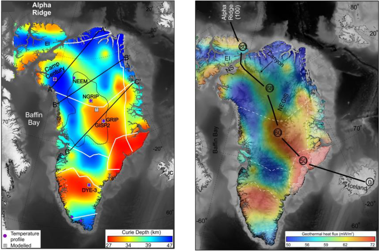
Estimated Curie depth variation below Greenland (left) converted to geothermal heat flow variation (right). (Credit: Martos et al. 2018; Figures 1b and 1c)

Magnetic anomalies are created by magnetisation induced in magnetic minerals in rocks by the Earth’s magnetic field. Yet minerals lose their ability to be magnetised at temperatures above a threshold known as the Curie point, which is 580 °C for magnetite, the most abundant magnetic mineral. Depending on the geothermal heat flow the Curie point is exceeded at some depth in the lithosphere. So magnetic anomalies can safely be assumed to be produced only by rocks above the so-called Curie depth. Yasmina Martos of the British Antarctic Survey (now at the University of Maryland) and scientists from Britain, the US and Spain used a complex procedure, including gravity data and a few direct measurements of heat flow below Greenland as well as filtered aeromagnetic data, to estimate the variation in Curie depth beneath the ice cap. (Martos, Y.M. et al. 2018. Geothermal heat flux reveals the Iceland hotspot track underneath Greenland. Geophysical Research Letters, v. 45, online publication; doi: 10.1029/2018GL078289). Using that as an inverse proxy for heat flow they were able to map the likely geothermal variation beneath the island. Rather than a random and narrow variation in depth, as would be expected for roughly uniform heat flow, the Curie depth varied in a non-random way by over 20 km, equivalent to roughly 20 mW m-2.

The shallowest Curie depth and highest estimated heat flow occurs in East Greenland around Scoresby Sund where the largest sequence of Palaeocene flood basalts occur. It is also on a line perpendicular to the mid-Atlantic Rift system that meets the active Iceland plume. Running north-west from Scoresby Sund is a zone of locally high estimated heat flow. Martos et al. suggest that this is the track of Greenland’s motion over the Iceland hot spot from about 80 Ma to the period of maximum on-shore volcanism and the start of sea-floor spreading at around 50 Ma.

A fully revised edition of Steve Drury’s book Stepping Stones: The Making of Our Home World can now be downloaded as a free eBook

A new kind of seismology

The detection and analysis of earthquake waves has played a major role in the study of how the Earth works for more than a century. Seismology has laid bare the deep structure of our planet. Using records from seismographs that showed the arrival times at different sites of body waves propagated by a 1909 earthquake near Zagreb Croatian scientist Andrija Mohorovičić deduced that the upper Earth was layered. His name is given to the boundary between the crust and underlying mantle; the Mohorovičić Discontinuity (Moho for short). Applying the principles of wave reflection and refraction to wave-arrival times from major seismic events at seismographic stations across the Earth’s surface resulted in the discovery of deeper discontinuities in the mantle and the structure of the core. As the number of stations increased, largely as a result of the need to detect and pin-point tests of nuclear weapons, reversing the principles enabled the 3-D positions of lesser events to be plotted. The resulting swathes of seismicity defined the boundaries of tectonic plates, and from the varying depths at which earthquakes occurred came ideas about their nature; especially important for the mapping of subduction zones. Expansion and standardisation of the global seismographic network and the millions of records that it has produced, together with advances in their digital analysis, has created the current method of charting deep-Earth properties using seismic tomography. A remarkable outcome of such studies is the strikingly named ‘The Atlas of the Underworld’.

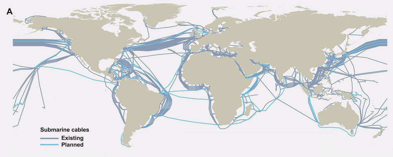
Up to now there has been a limit to the scope of such studies, particularly their resolution of features in the Earth’s mantle. Almost all the recording stations are on land, leaving the 70% of the surface covered by oceans devoid of data. Yet that might be set to change. The building of the Internet’s World Wide Web has largely depended on a growing network of telecommunications optic-fibre cables that criss-cross the oceans as well as the continents, stretching about a million kilometres. Using lasers at each end of a cable and interferometric analysis of two light signal that takes up a tiny proportion of the cable’s bandwidth it is possible to detect noise due to disturbances of the cable that result from earthquakes. On land this is compromised by local effects, such as traffic noise, but the ocean floors are remarkable quiet. Giuseppe Marra of Britain’s National Physical Laboratory discovered the potential of using optic fibre while testing a 79 km length cable linking atomic clocks at NPL and Reading (Marra, G. And 11 others 2018. Ultrastable laser interferometry for earthquake detection with terrestrial and submarine cables. Science online publication; doi:10.1126/science.aat4458). Purely by chance he observed unusually high spikes in noise during 2016. By no stretch of the imagination could they have been caused by events along the course of the cable. Curious, he eventually tracked the signals down to a series of earthquakes beneath Norcia in central Italy that cause death and destruction between 24 August and 30 October 2016. With a magnitude of 6.5, the last was the largest seismic event in Italy for 36 years. Subsequently, he and colleagues picked up the signal of a far less energetic event beneath the Mediterranean Sea (magnitude 3.4) from a cable linking Malta and Sicily.

F1.large
Map of submarine optic-fibre cables (credit: TeleGeography’s Telecom Resources)

With records from three suitably equipped cables an earthquake focus could be located precisely using triangulation. Together with the recorded signals, it would also be possible to use high magnitude earthquakes detected by optic-fibre cables to add to conventional seismic tomography, thereby sharpening the 3-D images of the deep Earth, which at present are plagued by blurring of much useful detail. Since both submarine and terrestrial cables might be used, such a method may become a bonanza for geophysicists

See also: Hand, E, 2018. Seafloor fibre optic cables can listen for earthquakes. Science, v. 360, p. 1160.

A fully revised edition of Steve Drury’s book Stepping Stones: The Making of Our Home World can now be downloaded as a free eBook

Late Palaeozoic glacial features in Chad

The longest and most extreme glacial epoch during the Phanerozoic took place between 360 and 260 Ma ago, when it dominated the Carboniferous and Permian sedimentary sequences across the planet. On continents that lay athwart the Equator during these times, sedimentation was characterised by cycles between shallow marine and terrestrial conditions. These are epitomised by the recurring ‘Coal-Measure’ cyclothem of, from bottom to top: open-sea limestone; near-shore marine mudstone; riverine sandstone; coal formed in swamps. This sequence represents a rapid rise in sea level as ice sheets melted, sustained during an interglacial episode and then falling sea level as ice once again accumulated on land to culminate in a glacial maximum when coal formed in coastal mires. During the Late Palaeozoic Era a single supercontinent extended from pole to pole. The break-up of Pangaea was charted by Alfred Wegener in 1912, partly by his using glacial deposits and ice-gouged striations on the southern continents. With the present widely separated configuration of major landmasses glacial sediments and the directions of inferred ice movements could only be reconciled by reassembling Africa, India, South America, Antarctica and Australia in the form of a single, congruent southern continent that he called Gondwanaland. In Wegener’s reconstruction the glacial features massed together on Gondwanaland with the striations radiating outwards from what would then have been the centre of a huge ice cap.

There are many localities on the present southern continents where such striations can be seen on the surface of peneplains etched into older rocks that underlie Carboniferous to Permian tillites, but later erosion has removed the continuity of the original glacial landscape. There are, however, some parts of central Africa where it is preserved. By using the high-resolution satellite images (with pixels as small as 1 m square) that are mosaiced together in Google Earth, Daniel Paul Le Heron of Royal Holloway, University of London has revealed a series of 1 to 12 km wide sinuous belts in a 6000 km2 area of eastern Chad that are superimposed unconformably on pre-Carboniferous strata (Le Heron, D.P. 2018. An exhumed Paleozoic glacial landscape in Chad. Geology, v.46(1), p. 91-94; doi:10.1130/G39510.1). They comprise irregular tracts of sandstone to the south of a major Carboniferous sedimentary basin. Zooming in to them (try using 17.5° N 22.25°E as a search term in Google Earth) reveals surfaces dominated by wavy, roughly parallel lines. Le Heron interprets these as mega-scale glacial lineations, formed by ice flow across underlying soft Carboniferous glacial sediments as seen in modern glacial till landforms in Canada. In places they rest unconformably on older rocks, sometimes standing above the level of the sandstone plateaux as relics of what may have been nunataks. There are even signs of elliptical drumlins.

An oblique Google Earth view looking to the south-east shows mega-scale glacial lineations from a glacial flow way in eastern Chad. The lower-right quadrant shows the unconformity atop older bedded strata that are dipping to the west. Click on the image to see a full resolution view. (Credit: Google Earth)

Glacial tillites and glaciofluvial sediments of Late Palaeozoic age are common across the Sahara and in the Sahelian belt, but in areas as remote as those in eastern Chad. So a systematic survey using the resolving power of Google Earth may well yield yet more examples. It is tedious work in such vast areas, unless, of course, one bears in mind Alfred Wegener, the founder of the hypothesis of continental drift and ‘Big’ Earth Science as a whole, who would have been gleeful at the opportunity.

A fully revised edition of Steve Drury’s book Stepping Stones: The Making of Our Home World can now be downloaded as a free eBook

Lid tectonics on Earth

Geoscientists have become used to thinking of the Earth as being dominated by plate tectonics in which large, rigid plates of lithosphere move across the surface. They are driven mainly by the sinking of cold, densified lithosphere in slabs at subduction zones. The volume of recycled slabs is replaced by continual supply of mafic magma to form oceanic crust at constructive margins. Such a process has long been considered to have reached far back into the Precambrian past and there are lively debates concerning when this modus operandi first arose and what preceded it. Now that we know more about other rocky planets and moons it appears that Earth is the only one on which plate tectonics has occurred. The other, more common, behaviour is dominated by stagnancy, although some worlds evidence volcanism and resurfacing as a result of giant impacts. Their subdued activity has come to be known as ‘lid tectonics’, in which their highly viscous innards slowly convect beneath a rigid, stagnant lid through which thermal energy is lost by convection: they are ‘one-plate’ systems. Although Earth loses internal heat by conduction through plate interiors, a large amount dissipates by convection associated with constructive margins: the oceanic parts of its plates lose heat laterally, as they grow older. Six papers in an advance, online issue of the free-access journal Geoscience Frontiers are concerned with the issue of terrestrial lid-tectonics and whether or not it dominated the Earth repeatedly in its Precambrian history.

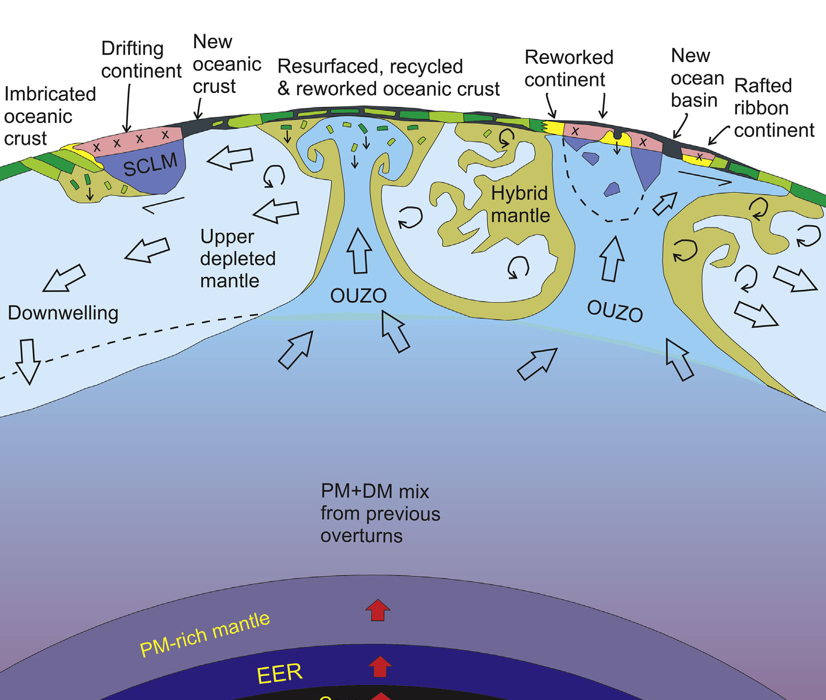
A model is emerging for a hot, early Earth that was dominated by a form of lid tectonics (Bédard, J.H. 2018 Stagnant lids and mantle overturns: implications for Archaean tectonics, magmagenesis, crustal growth, mantle evolution, and the start of plate tectonics. Geoscience Frontiers, v. 9, 19-49; https://doi.org/10.1016/j.gsf.2017.01.005). Bedard’s model centres on lithosphere that was so weak because of its temperature that its subduction was impossible. Density of the lithosphere rarely increased above that of the mantle because the necessary mineralogical changes were not achieved – those involved in plate tectonics require low-temperature, high-pressure metamorphism as oceanic lithosphere is driven down at modern subduction zones. Even if such reactions did happen, the lithosphere would have been too weak to sustain slab-pull force and dense lithosphere would have simply ‘dripped’ back to the mantle. Mantle convection in a hotter Earth would have been in the form of large, long-lived upwelling zones rather than the relatively ephemeral and narrow plumes known today. Low density materials resulting from magma fractionation, the precursors of continental crust, would have been shifted willy-nilly across the face of the planet to collide. accrete and undergo repeated partial melting. In Bedard’s view, plate tectonics arose as Earth’s heat production waned below a threshold that permitted rigid lithosphere, probably in the late Archaean, to dominate after 2.5 Ga.

Bédard’s impression of an early Archaean lid-tectonic scenario. (credit: Jean H Bédard 2018, Figure 3B)

A radically different view is that stagnant-lid episodes alternated with periods of limited subduction and plate tectonics in the Archaean. Some Archaean cratons – the so-called ‘granite-greenstone terrains – seems to provide geological evidence for lid tectonics (Wyman, D. 2018. Do cratons preserve evidence of stagnant lid tectonics? Geoscience Frontiers, v. 9, 19-49; https://dx.doi.org/10.1016/j.gsf.2017.02.001). Others, such as the famous Isua supracrustal belt in West Greenland hint at plate tectonics. John Piper, of Liverpool University in Britain, argues from a series of Archaean palaeomagnetic polar wander curves that in three periods – ~2650 to 2200 Ma, 1550 to 1250 Ma, and 800 to 600 Ma – the poles shifted comparatively slowly with respect to the cratons providing the magnetic data; a feature that Piper ascribes to dominant lid tectonics (Piper, J.D.A., 2018. Dominant Lid Tectonics behaviour of continental lithosphere in Precambrian Times: palaeomagnetism confirms prolonged quasi-integrity and absence of Supercontinent Cycles. Geoscience Frontiers, v. 9, p. 61-89; https://doi.org/10.1016/j.gsf.2017.07.009). Similarly, there is some evidence based on the geochemical variation of basaltic rocks derived from the mantle. Through the Archaean, geochemical changes roughly follow cycles in the abundance of zircon radiometric ages and other geological changes that may reflect plate- and lid-tectonic episodes (Condie, K.C. 2018. A planet in transition: the onset of plate tectonics on Earth between 3 and 2 Ga? Geoscience Frontiers, v. 9, p. 51-60; https://doi.org/10.1016/j.gsf.2016.09.001). Interestingly, the age-frequency plot of almost three thousand Archaean and Hadean zircons recovered from the famous 1.6 Ga old sandstones of the Jack Hills Formation in Western Australia reveals similar cycles that may reflect such tectonic fluctuations in the Hadean (Wang, Q. & Wilde, S.A. 2017. New constraints on the Hadean to Proterozoic history of the Jack Hills belt,Western Australia. Gondwana Research, v. 55, p. 74-91; https://doi.org/10.1016/j.gr.2017.11.008). Since zircons are most likely to crystallize from intermediate and felsic magmas – i.e. precursors of continental material – their abundance in the Jack Hills rocks suggests that their source must have been in the 3.7 to 3.3 Ga gneisses on which the younger sediments rest. That is, part of those Archaean gneisses may well be made up of Hadean continental material that was repeatedly reworked and maybe remelted since such crust first appeared (in the form of surviving zircons) around 4.4 to 4.5 Ga, perhaps during vigorous lid-tectonic regimes.

Possible evolution of magmatic and tectonic styles for large silicate planets. (Credit: Stern et al. 2018, Figure 3)

Based on their reassessment of tectonic activity revealed by 8 rocky planets and moons Robert Stern of the University of Texas (Dallas) and colleagues from ETH-Zurich suggest a possible evolutionary sequence of tectonics and magmatism that Earth-like bodies might go through (Stern, R.J. et al. 2018. Stagnant lid tectonics: Perspectives from silicate planets, dwarf planets, large moons, and large asteroids. Geoscience Frontiers, v. 9, p. 103-119 ; https://doi.org/10.1016/j.gsf.2017.06.004). In their scheme plate tectonics requires certain conditions of lithospheric density and strength to evolve and suggest that, depending on planetary characteristics, slab-pull driven tectonics is likely to be preceded and followed by stagnant lid tectonics, to give perhaps a cyclical geotectonic history.

A fully revised edition of Steve Drury’s book Stepping Stones: The Making of Our Home World can now be downloaded as a free eBook

Mega-impacts and tectonics

Because they are fast as well as weighty, destination-Earth asteroids and comets pack quite a punch. That is because their kinetic energy is proportional to the square of their speed (at least 13 km s-1) as well as half their mass. So, even all one half a kilometre across carries an energy a hundred times the solar energy received by Earth in a year, and a great deal more when compared with geothermal heat production. Much of the focus on the effects of impact events has dwelled on the upper crust, the oceans and atmosphere. Yet they also have huge seismic effects, with a proportion of their shock effect being dissipated throughout the entire planet. One obvious consequence would be a thermal anomaly directly beneath the crater as well as some thinning of the lithosphere and body waves affecting the rest of the solid Earth.

Thermal and mechanical processes lie at the core of tectonics, so a big question has been ‘Could impacts create mantle plumes or set new tectonic processes in motion?’ There has been speculation of diverse kinds since impacts became popular following the link between the Chicxulub crater and the end-Cretaceous mass extinction, discovered in 1980. But ‘educated guesses’ have generated more hot air than clear conclusions. Much as most of us are modelling-averse, a mathematical approach is the only option in the welcome absence of any severe extraterrestrial battering to which scientists have borne witness. With refined algorithms that cover most of the nuances of projectiles and targets – conservation of mass, energy and momentum in the context of the solid Earth behaving as a viscous medium –  Craig O’Neill and colleagues at Macquairie University, Australia, and the Southwest Research Centre in Boulder, CO USA, have simulated possible tectonic outcomes during plausible bombardment scenarios during the Hadean (O’Neil, C. et al. 2017. Impact-driven subduction on the Hadean Earth. Nature Geoscience, v. 10, p. 793-797; DOI: 10.1038/NGEO3029).

It appears that truly gargantuan objects – radius >500 km – are required to stimulate sufficient thermal anomalies that would lead to mantle upwellings whose evolution might lead to subduction at their margins. One at the limit posed by lunar cratering history (~1700 km radius) could have resulted in wholesale subduction of the entire lithosphere present at the time about 4 Ma after the impact. In the Hadean, it is likely that the lithosphere would have had a roughly mantle composition, so that the density excess needed for slab descent would have been merely temperature dependent. Note: after the onset of a basalt-capped lithosphere heat flow would have needed to be below the limit at which basalt converts to eclogite at high pressures, and thus to a density greater than that of the mantle, for continuing subduction. The authors’ Hadean scenario is one of episodic subduction dependent on the projectile flux and magnitude; i.e. with an early Hadean with stop-start subduction waning to tectonic stagnation and then a restart during the Late Heavy Bombardment after 4.1 Ga. Evidence for this is clearly scanty, except for Hadean zircons, whose presence indicates differentiation of early magmas with a peak between 4.0 to 4.2 Ga, in which magnetic intensities are preserved that are roughly as predicted by the scenario.

No impacts preserved in Precambrian to Recent times suggest extraterrestrial objects with the power to induce significant changes to global tectonics.

Recycling of continental crust through time

Because continental crust is so light – an average density of 2700 kg m-3 compared with the mantles’ value of 3300 – it has been widely believed that continents cannot be subducted en masse. Yet it is conceivable that sial can be ‘shaved’ from below during subduction and from above by erosion and added to subductable sediment on the ocean floor. Certainly, there is overwhelming evidence for the net growth of continents through time and plenty for periods of increased and dwindling growth in the past. In some ancient orogens there are substantial slabs of continental composition whose mineralogy bears witness to ultra-high pressure metamorphism at depths greater than that of the base of continents. These slabs had been caught-up in subduction but never reached sufficiently high density to be retained by the mantle; they eventually ‘bobbed up’ again. On the other hand, if early continents were less silica rich through incorporation of substantial proportions of rock with basaltic composition parts of them could founder if subjected to high-pressure, low-temperature metamorphism. But not all crustal recycling to the mantle is through subduction. Some abnormally highly elevated parts of the continents that rose quickly in geological terms, such as the Tibetan Plateau, may have formed by lower crustal slabs becoming detached or delaminated from their base. Again modelling can help assess the past magnitude of continental recycling (Chowdhury, P. et al. 2017. Emergence of silicic continents as the lower crust peels off on a hot plate-tectonic Earth. Nature Geoscience, v. 10, p. 698-703; DOI: 10.1038/NGEO3010).

Various lines of evidence suggest that between 65 to 70% of the present continental volume existed by 3 billion years ago, yet that does not manifest itself in the rock record; perhaps a sign that some has returned to the mantle. It is also widely suggested that plate tectonics in the modern style began at about that time. Pryadarshi Chowdhury and colleagues simulate what may happen at depth in continent-continent collision zones – the classic site of orogenies –at different times in the past. Under the hotter conditions in the early Archaean mantle delamination would have been more likely than it has been during the Phanerozoic; i.e. the peeling off and sinking of the denser, more mafic lower crust and the attached upper mantle. The authors show that increased mantle temperature further back in time increases the likelihood and extent of such delamination. It also encourages partial melting of the descending continental material so creating rising bodies of more silicic magma that add to the remaining continent at the surface. Together with the lower crust’s attachment of to a mantle slab, this ensures that the peeled off material is able to descend under its own load. Once below a depth of 250 km felsic rocks are doomed to further descent. Waning of radiogenic mantle heat production encourages descending slabs to fail and break from the connection with lithosphere at higher levels so that a smaller proportion of the lower crust becomes detached and recycled. This evolution suggests that less and less continental crust is recycled with time. This broadly fits with current geochemical ideas based on the record of radiogenic Nd-, Sr- and Pb-isotopes in rocks ranging from early Archaean to Phanerozoic age.

Plate tectonic graveyard

Where do old plates go to die? For the most part, down subduction zones to mix with their original source, the mantle. Earth-Pages has covered evidence for quite a few of the dead plates, which emerges from a geophysical technique known as seismic tomography – analogous to X-ray or magnetic resonance scans of the whole human body. For 20 years geophysicists have been analysing seismograms from many stations across the globe for every digitally recorded earthquake, i.e. virtually all of those since the 1970s. This form of depth sounding goes far beyond early deep-Earth seismometry that discovered the inner and outer core, various transition zones in the mantle and measured the average variation with depth of mantle properties. Tomography relies on complex models of the paths taken by seismic body waves and very powerful computing to assess variations in the speed of P- and S-waves as they travelled through the Earth: the more rigid/cool the mantle is the faster waves travel through it and vice versa. The result is images of deep structure in 2-D slices, but the quality of such sections depends, ironically, on plate tectonics. Most earthquakes occur at plate boundaries. Such linearly distributed, one-dimensional sources inevitably leave the bulk of the mantle as a blur. Around 20 different methodologies have been developed by the many teams working on seismic tomography. So sometimes conflicting images of the deep Earth have been produced.

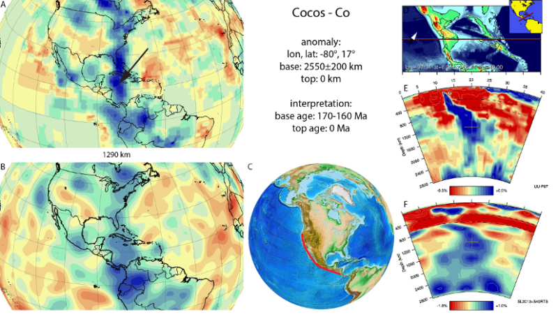
Results of seismic tomography across Central America showing anomalously fast (in blue) P- (top) and S-wave (bottom) speeds in map view at a fixed mantle depth (1290 km, left) and as vertical sections (right). The blue zones at right are interpreted to show a steeply dipping slab that represents subduction of the eastern Pacific Cocos plate since about 175 Ma ago (credit: van der Meer, D.G et al. ‘Atlas of the Underworld)

The technique has come of age now that superfast computing and use of multiple models have begun to resolve some of tomography’s early problems. The latest outcome is astonishing: ‘The Atlas of the Underworld’ catalogues 94 2-D sections from surface to the core-mantle boundary each of which spans 40° or arc – about a ninth of the Earth’s circumference (see: van der Meer, D.G., van Hinsbergen, D.J.J., and Spakman, W., 2017, Atlas of the Underworld: slab remnants in the mantle, their sinking history, and a new outlook on lower mantle viscosity, Tectonophysics online; doi.org/10.1016/j.tecto.2017.10.004). Specifically, the Atlas locates remnants of relatively cold slabs in the mantle that are suspected to be remnants of former subduction zones, or those that connect to active subduction. The upper parts of active slabs are revealed by the earthquakes generate along them. At deeper levels they are too ductile to have seismicity, so what form they take has long been a mystery. Once subduction stops, so do the telltale earthquakes and the slabs ‘disappear’.

The slabs covered by the ‘Atlas’ only go back as far as the end of the Permian, when the current round of plate tectonics began as Pangaea started to break-up. It takes 250 Ma for slabs to reach the base of the mantle and beyond that time they will have heated up and begun to be mixed into the lower mantle and invisible. Nevertheless, the rich resource allows models of vanished Mesozoic to Recent plates and the tectonics in which they participated, based on geological information, to be evaluated and enriched. Just as important, the project opens up the possibility of finding out how the mantle ‘worked’ since Pangaea broke up, in 3-D; a key to more than plate tectonics, including the mantle’s chemical heterogeneity. Already it has been used to estimate changes in the total length of subduction zones since 250 Ma ago, and thus arc volcanism and CO2 emissions, which correlates with estimates of past atmospheric CO2 levels, climate and even sea levels.

See also:  Voosen, P. 2016. ‘Atlas of the Underworld’ reveals oceans and mountains lost to Earth’s history. Science; doi:10.1126/science.aal0411.

Lee, H. 2017. The Earth’s interior is teeming with dead plates. Ars Technica UK, 18 October 2017.

Zealandia: a hitherto undiscovered continent?

Mid-February 2017 saw the announcement in the world’s media of what was made out to be a previously unsuspected, drowned continent. No, not in the Atlantic, but surrounding New Zealand. For geoscientists this was not ‘fake news’, but neither was it a surprise. Precise bathymetry based on satellite data rather than more conventional soundings from ships had long shown a substantial area (4.9 million km2) of the Coral and Tasman Seas between Australia and New Zealand and the Pacific to the immediate south-east of New Zealand was considerably less deep than the mean for the world’s ocean floors. It shows up clearly on Google Earth.  The name ‘Zealandia’ had been suggested in 1995. The media flurry emerged from a paper published in the March/April 2017 issue of the Geological Society of America’s on-line newsletter (Mortimer, N. and 10 others 2017. Zealandia: Earth’s hidden continent. GSA Today, v. 27(3 March April 2107); doi:10.1130/GSATG321A.1), the phrase ‘hidden continent’ no doubt pulling in the hacks like mackerel to a piece of tin foil.

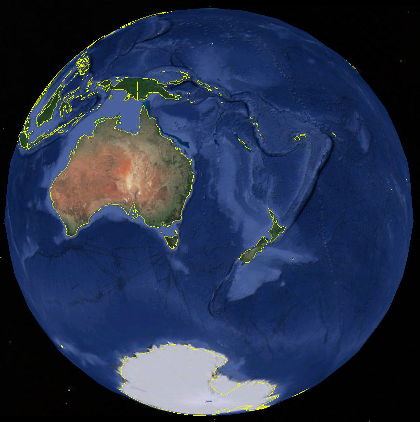
The extent of Zealandia shown by Google Earth – the paler the blue coloration the shallower the ocean floor

The 10 New Zealander authors with one Australian, based their definition of the anomalously shallow ocean floor as a continent on data accumulated over many years from geophysical surveys and spot sampling of rocks from dredging, drilling and field work on the area’s few islands as well as New Zealand itself. As well as being at a relatively high elevation – a mean of -1100 m compared with -3700 for the oceans as a whole – samples are  predominantly those expected from continental crust. In fact orogenic belts exposed in New Zealand can be traced lithologically and topographically on several large submerged ridges. Samples of its underlying mantle found as xenoliths in igneous rocks yield radiometric dates of 2.7 billion years. So it is an ancient entity, unlike oceanic crust none of which exceeds about 200 Ma. The ocean floor also exhibits a number of sedimentary basins dating back to the Cretaceous, which contain terrigenous clastic rocks and limestones that reach thicknesses of 2 to 10 km. Seismic surveys give an average P-wave speed of 6.5 km s-1 through the underlying crust, a density of 2830 kg m-3 and a crustal thickness between 30 and 46 km, none of which apply to mafic oceanic crust.

There are plenty of areas on the ocean floor that have such continental affinities, but they are small and referred to as microcontinents. To be dubbed ‘continent’ obviously involves an essence of mightiness, but for geologists the term also implies a lack of connection: hence Europe is a mere part of the Eurasian continent. The six geologically recognised continents (Africa, Eurasia, North America, South America, Antarctica, and Australia) are spatially isolated by geological and/or bathymetric features. Zealandia obeys that criterion, but only just: its NW end comes as close as 25 km to the crust of Australia, but the line of separation is a major fracture zone and 3600 m deep trough. However, Zealandia is considerably smaller than the recognised continents, but about the size of India and Arabia which some have regarded as having been a continent (India) and one in the process of formation (Arabia). Mortimer and co suggest that the size needed to be called a continent should be >1 million km2, which would clearly put New Zealand on a continent separate from Australia – long a source of irritation to Kiwis!

Setting aside any suggestion of some nationalist motives, Zealandia is very interesting. The very fact that it is uniquely drowned require some explanation. A great deal of evidence suggests that once being at the flank of Gondwanaland an extensional plate margin spalled it away around 85 Ma ago. In so doing tectonic forces substantially thinned the crust in a similar manner to what is presently happening on a smaller scale beneath the Afar Depression of Ethiopia. That would tend to result in widespread subsidence once any thermal buoyancy during rifting had cooled to increase crustal density. Such a process would explain the alternations of linear ridges and troughs that characterise this section of continental crust, but are less developed in the other continents.

More on continental growth and plate tectonics

http://www.bbc.co.uk/news/world-asia-39000936

https://www.thesun.co.uk/news/2887128/what-is-zealandia-new-continent/

Archaean continents derived from Hadean oceanic crust

As DNA is to tracing  human evolution and migration, so various isotope systems are to the evolution of the Earth. One of the most fruitful is the samarium-neodymium (Sm-Nd) system. The decay of 147Sm to 143Nd is used in dating rocks across the full range of Earth history, given coeval rocks with a suitable range of Sm/Nd ratios, because the decay has a long half life (1.06 x 10¹¹ years). However, samarium has another radioactive isotope 147Sm with a half life that is a thousand times shorter (1.06 x 10⁸ years). So it remains only as a minute proportion of the total Sm in rocks, most having decayed since it was formed in a pre-Solar System supernova. But its daughter isotope 142Nd is present in easily measurable quantities, having accumulated from 147Sm decay over the first few hundred million years of Earth’s history; i.e. during the Hadean and earliest Archaean Eons. It is this fact that allows geochemists to get an indirect ‘handle’ on events that took place in the Earth’s earliest, largely vanished history. The principle behind this approach is that when an ancient rock undergoes partial melting to produce a younger magma the rock that crystallizes from it inherits the relative proportions of Nd isotopes of its source and thereby carries a record of the earlier history.

English: An outcrop of metamorphosed volcanose...
Metamorphosed volcanosedimentary rocks from the Porpoise Cove locality, Nuvvuagittuq supracrustal belt, Canada. Possibly the oldest rocks on Earth. (credit: Wikipedia)

The eastern shore of Hudson Bay in Canada hosts the oldest tangible geology known, in form of some metamorphosed basaltic rocks dated at 4200 Ma old known as the Nuvvuagittuq Greenstone Belt – the only known Hadean rocks. They occur in a tiny (20 km2) patch associated with gneisses of tonalite-trondjhemits-granodiorite composition that are dated between 3760 and 3350 Ma. Engulfing both are younger (2800 to 2500 Ma) Archaean plutonic igneous rocks of felsic composition. Jonathan O’Neil and Richard Carlson of the University of Ottawa, Canada and the Carnegie Institution for Science, Washington DC, USA respectively, measured proportions of Nd isotopes in both sets of felsic igneous rocks (O’Neil, J. & Carlson, R.W. 2017. Building Archean cratons from Hadean mafic crust. Science, v. 355, p. 1199-1202; doi:10.1126/science.aah3823).

The oldest gneisses contained relative proportions of 142Nd commensurate with them having been formed by partial melting of the Hadean mafic rocks about a few hundred million years after they had been erupted to form the oldest known crust; no surprise there. However, the dominant components of the local continental crust that are about a billion years younger also contain about the same relative proportions of 142Nd. A reasonable conclusion is that the Archaean continental crust of NE Canada formed by repeated melting of mafic crust of Hadean age over a period of 1.5 billion years. The modern Earth continually replenishes its oceanic crust over about 200 Ma due to plate tectonics. During the Archaean mantle dynamics would have been driven faster by much higher internal heat production. Had this involved simply faster plate tectonics the outermost skin of mafic crust would have been resorbed into the mantle even faster. By the end of the Archaean (2500 Ma) barely any Hadean crust should have been available to produce felsic magmas. But clearly at least some did linger, adding more weight to the idea that plate tectonics did not operate during the Hadean and Archaean Eons. See Formation of continents without subduction below.

Formation of continents without subduction

The formulation of the theory of plate tectonics provided plausible explanations for the growth of continental crust over time, among many other fundamental Earth processes. Briefly expressed, once basalt capped oceanic lithosphere is forced downwards at plate boundaries where plates move towards one another, beyond a certain penetration cool, moist basalt undergoes a pressure-controlled change of state. Its chemical constituents reassemble into minerals more stable under elevated pressure. In doing so, one outcome involves dehydration reactions the other being that the bulk composition is recast mainly in the form of high-pressure pyroxene and the mineral garnet: the rock eclogite. The density of the basaltic cap increases above that of the mantle. Gravity acts to pull the subducting slab downwards, this slab-pull force being the main driver of plate motions globally. Water vapour and other fluids shed by dehydration reactions rise from the subducted slab into the wedge of overlying mantle to change its conditions of partial melting and the composition of the magma so produced. This is the source of arc magmatism that persists at the destructive plate margin to increase the volcanic pile’s thickness over time. When magma is able to pond at the base of the new crust its fractional crystallisation produces dense cumulates of high-temperature mafic silicates and residual melt that is both lighter and more enriched in silica. Residual magma rises to add to the middle and upper crust while the cumulate-rich lower crust becomes less gravitationally stable, eventually to spall downwards by delamination. Such a process helps to explain the bulk low density of continental crust built up over time together with the freeboard of continents relative to the ocean floor: a unique feature of the Earth compared with all other bodies in the Solar System. It also accounts for the vast bulk of continental crust having remained at the surface since it formed: it rarely gets subducted, if at all.

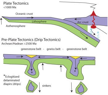
One suggested model for pre-plate tectonic continent formation (credit, Robert J Stern https://speakingofgeoscience.org/2013/04/28/when-did-plate-tectonics-begin-on-earth-and-what-came-before/)

Tangible signs that such subduction was taking place in the past – eclogites and other high-pressure, low-temperature metamorphosed basalts or blueschists – are only found after 800 Ma ago. Before that time evidence for plate tectonics is circumstantial. Some geologists have argued for a different style of subduction in earlier times, plates under riding others at low angles. Others have argued for a totally different style of tectonics in Earth early history, marked by changes in bulk chemical composition of the continental crust at the Archaean-Proterozoic boundary. A new twist comes from evidence in the Archaean Pilbara Craton of Western Australia (Johnson, T.E. et al. 2017. Earth’s first stable continents did not form by subduction. Nature, v. 543, p. 239-242; doi:10.1038/nature21383). The authors found that basalts dated at about 3.5 Ga have trace-element geochemistry with affinities to the primitive basalts of island arcs. That makes them a plausible source for slightly younger felsic plutonic rocks with a tonalite-trondhjemite-granodiorite (TTG) compositional range (characteristic of Archaean continental crust). If the basalts were partially melted to yield 30% of their mass as new magma the melt composition would match that of the TTG crust. This would be feasible at only 30 km depth given a temperature increase with depth of at least 25° C per kilometre; more than the average continent geothermal gradient today but quite plausible with the then higher heat production by less decayed radioactive isotopes of uranium, thorium and potassium 3.5 Ga ago. This would have required the basalts to have formed a 30 km thick crust. However, the basalts’ geochemistry requires their generation by partial melting of earlier more mafic basalts rather than directly from the mantle. That early Archaean mantle melting probably did generate vast amounts such primary magma is generally acknowledged and confirmed by the common occurrence of komatiitic lavas with much higher magnesium content than common basalts of modern constructive margins. In essence, Johnson et al. favour thermal reworking of primitive Archaean crust, rather than reworking in a plate tectonic cycle.

More on continental growth and plate tectonics

See also

When did Plate Tectonics begin on Earth, and what came before?

Ancient oceanic lithosphere beneath the eastern Mediterranean

The extensive active subduction zones around the Pacific ocean are responsible for a dearth of oceanic lithosphere older than about 200 Ma that still remains where it formed. Trying to get an idea of pre-Mesozoic ocean-floor processes depends almost entirely on fragmented ophiolites thrust or obducted onto continent at destructive plate margins. Yet the characteristically striped magnetic signature above in situ oceanic lithosphere offers a good chance of spotting any old oceanic areas, provided the stripes are not imperceptible because of thick sediment cover.  One of the most intriguing areas of ocean floor is that beneath the eastern Mediterranean Sea in the 3 km deep Herodotus Basin, which has long been thought to preserve a relic of old ocean floor.  Roi Granot of Ben-Gurion University of the Negev, Israel has analysed magnetic data gathered along 7 000 km of survey lines and indeed there are vague traces of stripy geomagnetic variation that has a long wavelength, to be precise there are two bands of . Mathematical analysis of the magnetic profiles suggest that they have a source  about 13 to 17 km beneath the seabed: probably crystalline crust beneath thick Mesozoic sediments (Granot, R. 2016. Palaeozoic oceanic crust preserved beneath the eastern Mediterranean. Nature Geoscience, doi:10.1038/ngeo2784).

English: Age of oceanic lithosphere Deutsch: A...
Ages of oceanic lithosphere (credit: Wikipedia)

The shape of the anomalies cannot be matched with those of younger magnetic stripes, but can be modelled to fit with a sequence of normal-reverse-normal magnetic polarity preserved in continental sequences of early Carboniferous age, about 340 Ma ago. At that age, the lithosphere would by now be old, cold and dense enough to subside to the observed depth, but the fact that it escaped subduction during amalgamation of Pangaea in the Upper Palaeozoic or when Africa collided with Eurasia in the early Cenozoic is a puzzle. Granot reckons that it most likely formed in Pangaea’s great eastern ocean embayment, known as Palaeotethys. An interesting view, but one that does not seem likely to lead any further, simply because of the great depth to which the oceanic material is buried. The deepest yet to be achieved is only 12 km in the onshore Kola Superdeep Borehole in Russia. So the changes of getting samples are slim, even if the overlying sedimentary pile proves to have hydrocarbon potential.

English: Pangea animation
Pangea break-up animation ( credit: Wikipedia)

Here is the plate tectonic forecast

As computing power and speed have grown ever more sophisticated models of dynamic phenomena have emerged, particularly those that focus on meteorology and climatology. Weather and climate models apply to the thin spherical shell that constitutes Earth’s atmosphere. They consider incoming solar radiation and longer wavelength thermal radiation emitted by the surface sources and sinks of available power, linked to the convective circulation of energy and matter, most importantly water as gas, aerosols, liquid and ice in atmosphere and oceans. Such general circulation models depend on immensely complex equations that relate to the motions of viscous media on a rotating sphere, modulated by other aspects of the outermost Earth: the absorptive and reflective properties of the materials from which it is composed – air, rocks, soils, vegetation, water in liquid, solid and gaseous forms; different means whereby energy is shifted – speeds of currents and wind, adiabatic heating and cooling, latent heat, specific heat capacity of materials and more still. The models also have to take into account the complex forms taken by circulation on account of Coriolis’ Effect, density variations in air and oceans, and the topography of land and ocean floor. The phrase ‘and much more besides’ isn’t really adequate for such an enormous turmoil, for the whole caboodle has chaotic tendencies in time as well as 3-D space. The fact that such modelling does enable weather forecasting that we can believe together with meaningful forward and backward ‘snapshots’ of overall climate depends on increasing amounts of empirical data about what is happening, where and when. Models of this kind are also increasingly able to address issues of why such and such outcomes occur, an important example being the teleconnections between major weather events around the globe and phenomena such as the El Nino-Southern Oscillation – the periodic fluctuation of ocean movements, winds and sea-surface temperatures over the tropical eastern Pacific Ocean.

The key principle of plate tectonics is that t...
The Earth’s 15 largest tectonic plates. (credit: Wikipedia)

The Earth’s lithosphere and deeper mantle in essence present much the same challenge to modellers. Silicate materials circulate convectively in a thick spherical shell so that radiogenic heat and some from core formation can escape to keep the planet in thermal balance.  There are differences, the obvious ones being sheer scale and a vastly more sluggish pace, but most important are the interactions between materials with very different viscosities; the ability of the deep mantle to move by plastic deformation while the lithosphere moves as rigid, brittle plates. For geophysicists interested in modelling there are other differences; information that bears on the system is orders of magnitude less, its precision is much poorer and all of it is based on measurement of proxies. For instance, information on temperature comes from variations in seismic wave speed given by analysis of arrival times at surface observatories of different kinds of wave emitted by individual earthquakes. That is, from seismic tomography, itself a product of immensely complex computation. Temptation by computing power and the basic equations of fluid dynamics, however, has proved hard to resist and the first results of a general circulation model for the solid Earth have emerged (Mallard, C. et al. 2016. Subduction controls the distribution and fragmentation of Earth’s tectonic plates. Nature, v. 535, p. 140-143).

As the title suggests, the authors’ main objective was understanding what controls the variety of lithospheric tectonic plates, particularly how strain becomes localised at plate boundaries. They used a circulation model for an idealised planet and examined several levels of a plastic limit at which the rigidity of the lithosphere drops to localise strain. At low levels the lithosphere develops many plate boundaries, and as the plastic limit increases so the lithosphere ends up with increasingly fewer plates and eventually a rigid ‘lid’. The modelling also identified divergent and convergent margins, i.e. mid-ocean ridges and subduction zones. The splitting in two of a single plate must form two triple junctions, whose type is defined by the kinds of plate boundary that meet: ridges; subduction zones; transform faults. Both the Earth and the models show significantly more triple junctions associated with subduction than with extension, despite the fact that ridges extend further than do subduction zones. And these trench-associated triple junctions are mainly those dividing smaller plates. This suggests that it is subduction that focuses fragmentation of the lithosphere, and the degree of fragmentation is controlled by the lithosphere’s strength. There is probably a feedback between mantle convection and lithosphere strength, suggesting that an earlier, hotter Earth had more plates but operated with fewer, larger plates as it cooled to the present. But that idea is not new at all, although the modelling gives support to what was once mere conjecture.

So, when did plate tectonics start up?

Tiny, 4.4 billion year old zircon grains extracted from much younger sandstones in Western Australia are the oldest known relics of the Earth system. But they don’t say much about early tectonic processes. For that, substantial exposures of rock are needed, of which the undisputedly oldest are the Acasta gneisses 300 km north of Yellowknife in Canada’s North West Territories, which have an age of slightly more than 4 Ga. The ‘world’s oldest rock’ has been something of a grail for geologists and isotope geochemists who have combed the ancient Archaean cratons for 5 decades. But since the discovery of metasediments with an age of 3.8 Ga in West Greenland during the 1970s they haven’t made much headway into the huge time gap between Earth’s accretion at 4.54 Ga and the oldest known rocks (the Hadean Eon).

The Deccan Traps shown as dark purple spot on ...
Continental cratons (orange) where very-old rocks are likely to lurk. (credit: Wikipedia)

There have been more vibrant research themes about the Archaean Earth system, specifically the issue of when our planet settled into its modern plate tectonic phase A sprinkling of work on reconstructing the deep structural framework of Archaean relics has convinced some that opposed motion of rigid, brittle plates was responsible for their geological architecture, whereas others have claimed signs of a more plastic and chaotic kind of deformation of the outer Earth. More effort has been devoted to using the geochemistry of all the dominant rocks found in the ancient cratons, seeking similarities with and differences from those of more recent vintage. There can be little doubt that the earliest processes did form crust whose density prevented or delayed it from being absorbed into the mantle. Even the 4.4 Ga zircons probably crystallized from magma that was felsic in composition. Once trapped by buoyancy at the surface and subsequently wrapped around by similarly low density materials continental crust formed as a more or less permanent rider on the Earth’s deeper dynamics. But did it all form by the same kinds of process that we know to be operating today?

Plate tectonics involves the perpetual creation of rigid slabs of basalt-capped oceanic lithosphere at oceanic rift systems and their motions and interactions, including those with continental crust. Ocean floor cools as it ages and becomes hydrated by seawater that enters it. The bulk of it is destined eventually to oppose, head-to-head, the motions of other such plates and to deform in some way. The main driving force for global tectonics begins when an old, cold plate does deform, breaks, bends and drives downwards. Increasing pressure on its cold, wet basaltic top transforms it into a denser form: from a wet basaltic mineralogy (feldspar+pyroxene+amphibole) to one consisting of anhydrous pyroxene and garnet (eclogite) from which watery fluid is expelled upwards. Eclogite’s density exceeds that of mantle peridotite and compels the whole slab of oceanic lithosphere to sink or subduct into the mantle, dragging the younger parts with it. This gravity-induced ‘slab pull’ sustains the sum total of all tectonic motion. The water rising from it induces the wedge of upper mantle above to melt partially, the resulting magma evolves to produce new felsic crust in island arcs whose destiny is to be plastered on to and enlarge older continental masses.

Relics of eclogites and other high-pressure, low-temperature versions of hydrated basalts incorporated into continents bear direct and unchallengeable witness to plate tectonics having operated back to about 800 Ma ago. Before that, evidence for plate tectonics is circumstantial and in need of special pleading. Adversarial to-ing and fro-ing seems to be perpetual, between geoscientists who see no reason to doubt that Earth has always behaved in this general fashion and others who see room for very different scenarios in the distant past. The non-Huttonian tendency suggests an early, more ductile phase when greater radioactive heat production in the mantle produced oceanic crust so fast that when it interacted with other slabs it was hot enough to resist metamorphic densification wherever it was forced down. Faster production of magma by the mantle without slab-pull could have produced a variety of ‘recycling’ turnover mechanisms that were not plate-tectonic.

One thing that geochemists have discovered is that the composition of Archaean continental crust is very different from that produced in later times. In 1985 Ross Taylor and Scott McLennan, then of the Australian National University, hit on the idea of using shales of different ages as proxies for the preceding continental crust from which they had been derived by long erosion. Archaean and younger shales differed in such a way that suggests that after 2.5 Ga (the end of the Archaean) vast amounts of feldspar were extracted from the continent-forming magmas. This left the later Precambrian and Phanerozoic upper crust depleted in the rare-earth element europium, which ended up in a mafic, feldspar-rich lower crust. On the other hand, no such mass fractionation had left such a signature before 2.5 Ga. Another ANU geochemist, now at the University of Maryland, Roberta Rudnick has subsequently carried this approach further, culminating in a recent paper (Tang, M., Chen, K and Rudnick, R.L. 2016. Archean upper crust transition from mafic to felsic marks the onset of plate tectonics. Science, v. 351, p. 372-375). This uses nickel, chromium and zinc concentrations in ancient igneous and sedimentary rocks to track the contribution of magnesium (the ‘ma’ in ‘mafic’) to the early continents. The authors found that between 3.0 to 2.5 Ga continental additions shifted from a dominant more mafic composition to one similar to that of later times by the end of the Archaean. Moreover, this accompanied a fivefold increase in the pace of continental growth. Such a spurt has long been suspected and widely suggested to mark to start of true plate tectonics: but an hypothesis bereft of evidence.

A better clue, in my opinion, came 30 years ago from a study of the geochemistry of actual crustal rocks that formed before and after 2.5 Ga (Martin, H. 1986. Effect of steeper Archean geothermal gradient on geochemistry of subduction-zone magmas. Geology, v. 14, p. 753-756). Martin showed that plutonic Archaean and post-Archaean felsic rocks of the continental crust lie in distinctly different fields on plots of their rare-earth element (REE) abundances. Archaean felsic plutonic rocks show a distinct trend of enrichment in light REE relative to heavy REE as measures of the degree of partial melting decreases, whereas the younger crustal rocks show almost constant, low values of heavy REE/light REE whatever the degree of melting. The conclusion he reached was that while in the post Archaean the source was consistent with modern subduction processes – i.e. partial melting of hydrated peridotite in the mantle wedge above subduction zones – but during the Archaean the source was hydrated, garnet-bearing amphibolite of basaltic composition, in the descending slab of subducted oceanic crust. Together with Taylor and McLennan’s lack of evidence for any fractional crystallization in Archaean continental growth, in contrast to that implicated in Post-Archaean times.

The geochemistry forces geologists to accept that a fundamental change took place in the generation and speed of continental growth at the end of the Archaean, marking a shift from a dominance of melting of oceanic, mafic crust to one where the upper mantle was the main source of felsic, low-density magmas. Yet, no matter how much we might speculate on indirect evidence, whether or not subduction, slab-pull and therefore plate tectonics dominated the Archaean remains an open question.

More on continental growth and plate tectonics

Global Tectonics Centenary: Any Inspiring Papers?

Although Alfred Wegener first began to present his ideas on Continental Drift in 1912 his publication in 1915 of The Origin of Continents and Oceans (Die Entstehung der Kontinente und Ozeane) is generally taken as the global launch of his hypothesis. Apart from support from Alexander du Toit and Arthur Holmes, geoluminaries of the day panned it unmercifully because, in the absence of evidence for a driving mechanism, he speculated that his proposed ‘urkontinent’ (primal continent) Pangaea had been split apart by a centrifugal mechanism connected to the precession of Earth’s rotational axis. This ‘polflucht’ (flight from the poles) is in fact far too weak to have any such influence. Wegener’s masterly assembly of geological evidence for former links between the major continents was ignored by the critics, suggesting that their motive for excoriation of his suggested mechanism was as much spite against an ‘outsider’ as a full consideration of his hypothesis. It must have been hurtful in the extreme, yet Wegener defended himself with a series of revised editions that amassed yet more concrete evidence. What is often overlooked, even now that his ideas have become part of the geoscientific canon, is that in his initial Geologische Rundschau paper in 1912 he mused that the floor of the Atlantic is continuously spreading by tearing apart at the mid-Atlantic Ridge where ‘relatively fluid and hot sima’ rises. Strangely, he dropped that idea in later works. Anyhow, neither 2012 nor 2015 was celebrated in the manner of the centenary-and-a-half of Darwin’s On the Origin of Species: 2009 was marked by palaeobiologists and geneticists metaphorically dancing in the streets, if not foaming at the mouth. There have been a few paragraphs, and some minor symposia about Wegener’s dragging geology out of the 18th century and into the 20th, but that’s about it. The best centenary item I have seen is by Marco Romano and Richard Cifelli (Romano, M. & Cifelli, R.L. 2015. 100 years of continental drift. Science, v. 350, p. 916-916).

In the shape of plate tectonics the Earth sciences hosted what was truly a revolution in science, albeit 50 years on from its discoverer’s announcement. It was through the persistent agitation by his tiny band of supporters, that the upheaval was unleashed when the revelations from palaeomagnetism, seismology and many other lines of evidence were resolved as plate tectonics by the discovery of ocean-floor magnetic stripes by Vine, Matthews and Morley in 1963. Despite an explosion of papers that followed, elaborating onthe new theory and showing examples of its influence on ‘big’ geology , counter-revolutionary resistance lasted almost to the first years of the new century. By then so much evidence had emerged from every geological Eon that opponents looked truly stupid. Even so, the skepticism among those sub-disciplines that were ‘left out’ of geodynamic thought continued to blurt out with the emergence of other exciting aspects of the Earth’s history. I remember that, when three of us in the Open University’s Department of Earth Sciences proposed in 1994 that the influence of impacts by extraterrestrial objects ought to figure in a new course on the evolution of Earth and Life we were sneered at as ‘whizz-bang kids’ by those more earth-bound. Trying belatedly in 1996 to introduce students to another revolutionary development – the use of sedimentary and glacial oxygen isotopes in unraveling past climate change – became a huge struggle in the OU’s Faculty of Science. It went to the press eventually and for 2 years our students had the benefit. But the murmuration of dissent ended with a force-majeur re-edit of the course, by someone who had played no role in its development, expunged the lot and changed the ‘offending’ section back to the way it had been a decade before.  As they say: ho hum!

Oddly, in the last 15 years or so of trying to follow in Earth-Pages what I considered to be the most exciting developments in the geosciences, it has become increasing difficult to find papers in the top journals that are truly ground-breaking. Of course that may just be ageing and a certain cynicism that often companies it. From being spoiled for choice week after week it has become increasingly difficult from month to month to maintain the standards that I have set for new work. Has Earth science entered the fifth phase of a ‘paradigm shift’ predicted by philosopher Thomas Kuhn in his 1962 book The Structure of Scientific Revolutions? According to him once a science has entered a period when there is little consensus on the theories that might lie at the root of natural processes there is a drift in opinion to a few conceptual frameworks that seem to work, albeit leaving a lot to be desired. Weaknesses at the frontier between theory and empirical knowledge become increasingly burdensome as a result of the steady plod of ‘normal science’ until the science in question reaches a crisis. If existing paradigms fail repeatedly, science is ripe for the metaphorical equivalent of a ‘Big Bang’: maybe an entirely new discovery or hypothesis, or an idea that has been suppressed which new data fits better than any others that have been common currency. Plate Tectonics is the second kind. After the revolution much is reexamined and new lines of work emerge, until in Kuhn’s 5th phase scientists return to ‘normal science’. That looks like a pretty good story, on paper, but other forces are at work in science; external to scientific objectives. Most of these are a blend of economics, political ideologies and managerial ‘practicalities’. If the Earth sciences have entered the doldrums of novelty, I suspect it is these forces that are bearing some kind of glum fruit.

The old concept of academic freedom has gone by the board. Institutions demand that research is externally funded – the more the better as the institution, at least in the UK, demands a kind of tax (40% of that proposed) supposedly to cover corporate overheads including salaries of support staff. If an academic doesn’t pull in the dosh, she is not much favoured. If the individual doesn’t publish regularly either, there is a weasel sanction: Josephine Soap is declared ‘research inactive’. Consortia of researchers are more and more in vogue: managers and funders like ‘team players’, so individuals who are bright and confident enough to ‘stick their necks out’ cannot do that in a consortium publication and as often as not are ‘left on the bench’. Risk taking is more dangerous now and to stay ‘research active’, and in many cases of non-tenured posts getting a salary, an individual, even a few like-minded colleagues have to publish 2 or 3 papers a year.

It’s worth mentioning that open access publishing is not just all the rage, it has become more or less compulsory. Of course, it has some benefits for scientists in less well-heeled countries, but there is a downside. You have to raise the cash demanded by journals for the privilege or potentially universal access – at least US$1000 a pop, depending on a journals Impact Factor, and that of course is an odiously essential corporate consideration – and having done that woe betide those who do not publish and spend it. Academic publishing is the most profitable sector of the trade, the more so as print is supplanted by electronic delivery – the 50 free reprints is a thing of the past. So there are more and more journals and each of them strives to get out more issues per year, and of course those have to be filled. To me, this all adds up to more and more ‘pot-boiler’ articles and a tendency to maximise the flesh rendered from the body of research work and into the pot. Taken together with the stresses of commodification in higher education and the now vertical corporate structures from which it is constituted, it shouldn’t be a surprise that excitement and inspiration are at a premium in the weekly and monthly output of such a marginal science as that concerned with how the world works.

Some cunning radiometric dating

At the end of the 1970’s I was invited by the Deputy Director of the Geological Survey of India (Southern Region) to participate in the Great Postal Symposium on the Cuddapah Basin: a sort of harbinger of the Internet and Skype, but using snail-mail. Feeling pretty honoured and most intrigued I accepted; not that I knew the first thing about the subject. A regular stream of foolscap mimeographed contributions kept me nipping out of my office to check my pigeon hole for about 6 months. I learned a lot, but felt unable to comment. Four years on I was taken across the Cuddapahs by my first research student – a budding moto-cross driver with a morbid fear of bullock carts – en route from the Archaean low-grade greenstone-granite terrains of Karnataka for a peek at the fabled charnockites near Chennai (then Madras). A bit of a round-about route but spurred by my memories of the Great Postal Symposium. Sadly, the detour was marred for me by a severe case of sciatica brought on by manic driving, the state of the trans-Cuddapah highway and a misplaced gamma-globulin shot to ward off several varieties of hepatitis: I mainly blamed the nurse who demanded that I drop my drawers and bravely take the huge needle in a buttock – they do these things more humanely these days. Anyhow, apart from seeing many dusty villages build of slates perfect enough to make a full-size snooker table, my mind was elsewhere and I have long regretted that.

Landsat image mosaic showing part of the Cuddapah Basin.

Hosting possibly the world’s only diamondiferous Precambrian conglomerate, the Cuddapah Basin contains a 5 km thickness of diverse sedimentary strata, but no tangible fossils. It rests unconformably on the Archaean greenstone-granite terrain of the Dharwar Craton and so is Proterozoic in age; an Eon that spans 2 billion years. The middle of the lowest sedimentary formations (the Papaghni and Chitravati Groups) contains volcanic rocks dated at ~1.9 Ga; another group is cut by a ~1.5 Ga granite, and hitherto the youngest dateable event is the emplacement of 1.1 Ga kimberlites that sourced the diamonds in the conglomerate. Until recently the stratigraphy has been known in some detail, but how to partition it in Proterozoic time is barely conceivable with just three dates in the middle parts that span 800 Ma. All that can be said about the base of the Cuddapah sediments is that they are younger than the 3.1 to 2.6 Ga Archaean rocks beneath. Since the uppermost beds are truncated by a huge thrust system that shoved deep crustal granulites over them their minimum age is equally vague.

Structurally, the Basin began to form on a stable continent underpinned by the Dharwar Craton, but when that collided with Enderbyland in Antarctica, as part of the accretion of the Gondwana supercontinent, sedimentation may have been in an entirely different setting. Indeed, some of the sediments have been carried over the undisturbed part of the basin by a major thrust system. To explore both sedimentary and tectonic evolution Australian, Indian and Canadian geoscientists combined to sample and radiometrically date the entire pile (Collins, A.S. and 13 others 2015. Detrital mineral age, radiogenic isotopic stratigraphy and tectonic significance of the Cuddapah Basin, India. Gondwana Research, v. 28, p. 1294-1309). By precisely dating detrital micas and zircons from the sediments the team was able to check the source region of sedimentary grains as well as to establish a maximum age for each major stratigraphic unit. This helped establish a 3-part sedimentary and tectonic history. The earliest sediments came from the cratonic area to the west, but there are signs that collisional orogeny between 1590 and 1659 Ma produced a new sedimentary source in metamorphic rocks forming to the east. A return to westward provenance marked the youngest sedimentary setting. This enabled the team to suggest a dual evolution of the Basin, first as an extensional rift opening at the east of what is now the Dharwar craton followed by collisional orogeny that transformed the setting to that of a foreland basin, analogous to the Molasse basin in front of the Alps during Cenozoic times, ending with tectonic inversion when extension changed to compression and thrusting.

But to what extent did the work improve the age subdivision of the Cuddapah Basin? Apparently very little, which may be down to a problem with dating detrital minerals. If magmatic and metamorphic evolution was continuous in the areas from which sediments moved, then the youngest grain is a good guide to the maximum age of the sediment being analysed. The more strata are analysed in this way the better the detail of sedimentary timing. But two tectonic terrains are unlikely to produce zircons time and time again during a period approaching a billion years. The data indicate only 3 or 4 episodes of ‘zirconogenesis’ in the sedimentary hinterlands, between about 900 to 1940 Ma. Apart from helping correlate sedimentary formations that were previously deemed stratigraphically different – which did help in tectonically unravelling this complex major feature – several hundred isotopic analyses of zircons and micas have give much the same timing as was known already in more precise terms from stratigraphy assisted by a few dozen conventional radiometric dates.

The core’s influence on geology: how does it do it?

Although no one can be sure about the details of processes in the Earth’s core what is accepted by all is that changes in core dynamics cause the geomagnetic field to change in strength and polarity, probably through some kind of physical interaction between core and deep mantle at the core-mantle boundary (CMB). Throughout the last 73 Ma and especially during the Cenozoic Era geomagnetism has been more fickle than at any time since a more or less continuous record began to be preserved in the Jurassic to Recent magnetic ‘stripes’ of the world ocean floor. Moreover, they came in bursts: 5 in a million years at around 72 Ma; 10 in 4 Ma centred on 54 Ma; 17 over 3 Ma around 42 Ma; 13 in 3 Ma at ~24 Ma; 51 over a period of 12 Ma centring on 15 Ma. During the Late Jurassic and Early Cretaceous the core was similarly ‘busy’, the two time spans of frequent reversals being preceded by quiet ‘superchrons’ dominated by the same normal polarity as we have today i.e. magnetic north being roughly around the north geographic pole.

The Cenozoic history of magnetic reversals - black periods were when geomagnetic field polarity was normal and white when reversed. (credit: Wikipedia)
The Cenozoic history of magnetic reversals – black periods were when geomagnetic field polarity was normal and white when reversed. (credit: Wikipedia)

Until recently geomagnetic ‘flips’ between the two superchrons were regarded as random , perhaps suggesting chaotic behaviour at the CMB. But such a view depends on the statistical method used. A novel approach to calculating reversal frequency through time, however, shows peak-trough pairs recurring 5 times through the Cenozoic Era, approximately 13 Ma apart: maybe the chaos is illusory (Chane, J. et al. 2015. The 13 million year Cenozoic pulse of the Earth. Earth and Planetary Science Letters, v. 431, p. 256-263). So, here is a kind of yardstick to see if there may be any connection between core processes and those at the surface, which Chen of the Fujian Normal University, Fushou China and Canadian and Chinese colleagues compared with the very detailed Cenozoic oxygen-isotope (δ18O) record preserved by foraminifera in ocean-floor sediments, which is a well established proxy for changes in climate. Removing the broad trend of cooling through the Cenozoic resulted in a plot of more intricate climatic shifts that matches the geomagnetism record in both shape and timing of peak-trough pairs. It also turns out, or so the authors claim, that both measures correlate with changes in the rate of Cenozoic subduction of oceanic lithosphere (a measure of plate tectonic activity), albeit negative – peaks in magnetism and climate connecting with slowing in the pace of tectonics.

The analyses involved some complicated maths, but taken at face value the correlations beg the questions why and how? Long-term climate change contains an astronomical signal, encapsulated in the Milankovich hypothesis which has been tested again and again with little room for refutation. So is this all to do with gravitational influences in the Solar System. More exotic still is the possibility of 13 Ma cyclicity linking the Milankovich mechanism with the vaster scale of the Sun’s orbit oscillating through the disc of the Milky Way galaxy and theoretical hints of a mysterious role for dark matter in or near the galaxy. Or, is it a relationship in which climate and the magnetic field are modulated by plate tectonics through varying volcanic emissions of greenhouse gases and the deep effect of subduction on processes at the CMB respectively? To me that seems more plausible, but it is still as exceedingly complex as the maths used to reveal the correlations.

Continental hot-spot track in eastern Australia

cosgrove volcano track shown on map of australia
The Cosgrove volcanic track on a natural-colour image mosaic of Australia (credit: Drew Whitehouse, NCI National Facility VizLab)

It is sometimes forgotten that not only oceanic lithosphere provides evidence for hot spot tracks, probably because they are so obvious as island and seamount chains on bathymetric maps. They are not so clear on continents, either because of erosion of volcanoes or topography dominated by features that predate volcanism, but they account for about 20% of proposed tracks. Eastern Australia seems well endowed; four of them marked by a variety of volcanic structures that trend parallel to the Indo-Australian Plate’s NNE Cenozoic drift powered by the Southeast Indian Ridge that separates it from the Antarctic Plate. The timing of the volcanism along the proposed tracks is also highly persuasive. The longest of the tracks, extending about 2000 km SSW from Cape Hillsborough on the coast of central Queensland through New South Wales to Cosgrove in Victoria, is marked by sporadic volcanoes whose age decreases from Late Eocene in the north to Late Miocene in Victoria.

Unlike oceanic hot-spot tracks, those on continents are not continuous lines of volcanic occurrences. The Cosgrove track has several volcanic gaps, up to 650 km wide. This kind of patchy feature once encouraged hot-spot sceptics to question the tectonic affinities of what they regarded as fortuitous alignments. Where volcanic age trends consistent with the hypothesis emerged such doubts have faded into the background academic ‘noise’. In the case of the Cosgrove track all but one of the dates of volcanism tally quite well with the Cenozoic absolute motion of the Indo-Australian Plate and their position along the track (Davies, D.R. et al 2015. Lithospheric controls on magma composition along Earth’s longest continental hotspot track. Nature, v. 525, p. 511-514). Yet the objective of the authors, from the Australian National University and the University of Aberdeen in Britain, was not merely to establish the alignment as a hot-spot track, but to suggest what may have resulted in its marked patchiness.

The geochemistry of lavas from the volcanoes turns out to be of two fundamentally different types: ‘common-or-garden’ basalts in the case of Queensland and peculiar potassium-rich basalts containing the K-feldspathoid leucite in New South Wales and Victoria. Why these compositional differences occur where they do emerged very clearly when their positions were plotted on a new map of the thickness variations of the eastern Australian continental lithosphere. The ordinary basalts rest on the thinnest lithosphere (£110 km), whereas the leucitites are underlain by considerably thicker lithosphere (~135 km). This suggests that the rising mantle whose partial melting produced the magmas was halted at different depths, different geochemical ‘signatures’ of basalts depending on the pressure of melting. The most interesting outcome, albeit one based on an absence of evidence, is that the very large volcanic gaps along the track are each above much thicker lithosphere (>150 km). At those depths a rising mantle plume would be much less likely to begin melting.

Hotspots and plumes

One of the pioneers of plate tectonics, W. Jason Morgan, recognised in the 1970s that chains of volcanic islands and seamounts that rise from the ocean floor may have formed as the movement of lithospheric plates passed over sources of magma that lay in the mantle beneath the plates. He suggested that such hotspots were fixed relative to plate movements at the surface and likened the formation of chains such as that to the west of the volcanically active of the Hawaiian ‘Big Island’ to linear scorching of a sheet of paper moved over a candle flame. If true, it should be possible to use hotspots as a framework for the absolute motion of lithospheric plates rather than the velocities of individual plates relative to the others. But Morgan’s hypothesis has been debated ever since he formulated it. A test would be to see whether or not plumes of rising hot material in the deep part of the mantle can be detected. This became one of the first objectives of seismic tomography when it was devised in the last decade of the 20th century: a method that uses global earthquakes records to detect parts of the mantle where seismic waves traveled faster or slower than the norm: effectively patches of hot (probably rising) and cold rock. The first such evidence was equally hotly debated, one view being that the magma sources beneath oceanic islands such as Hawaii and Iceland were actually related to plate tectonics and that the hotspot hypothesis had become a kind of belief system.

English: global distribution of 45 identified ...
Global distribution of hotspots ( credit: Wikipedia)

The problem was that mantle plumes supposedly linked to magmatic hotspots in the upper mantle would be so thin that they would be difficult to detect even with seismic tomography. Geophysicists have been trying to sharpen up seismic resolution partly by using supercomputers to analyse more and more seismic records and also by improving the theory about how seismic waves interact with 3-D mantle structure. This has culminated in more believable visualisation of mantle structure (French, S.W. & Romanowicz, B. 2015. Broad plumes rooted at the base of the Earth’s mantle beneath major hotspots). The two researchers from the University of California at Berkeley in fact showed something different, but still robust support for Morgan’s 40-year old ideas. Instead of thin plumes, they have been able to show much broader conduits beneath at least 5 and maybe more active ends of hotspot chains. The zones extend upwards from the core-mantle boundary to about 1000 km below the Earth’s surface, where some bend sideways towards hotspots, perhaps as a result of another kind of upper mantle circulation.

Whole-Earth seismic tomography cross sections beneath a variety of volcanic islands, (Credit French and Romanowicz; http://www.nature.com/doifinder/10.1038/nature14876)

The sources of these hot columns at the core-mantle boundary appear to be zones of very low shear-wave velocities; i.e. almost, but not quite molten blobs. French and Romanowicz suggest that the columns are extremely long-lived and may even have a chemical dimension – as in the hypothesis of mantle heterogeneity. Another interesting feature of their results is that the striking vertical linearity of the columns could indicate that the overall motion of the lower mantle is extremely sluggish and punctured by discrete convection.

Thin- or thick-skinned tectonics: a test

How the continental lithosphere deforms at convergent plate margins has been a matter of opinion that depends on where observations have been made in ancient orogenic belts. One view is that arc and collisional orogens are dominated by deformation of the upper crust and especially the cover of sedimentary and volcanic rocks above deeper and older basement. This is a ‘thin-skinned’ model in which rocks of the upper crust are detached from those below and thicken more or less independently by thrust faulting, the formation of ductile nappes or a combination of the two. Mountain ranges, in this view, are the product of piling up of thrust slices or nappes, as exemplified by the Alps, Canadian Rockies and the Caledonian thrust belt of NW Scotland. Thick-skinned processes, as the name suggests, see crustal shortening and thickening as being distributed through the crust from top to bottom and even involving the lithospheric mantle. The hinterlands of both the Alps and the Scottish Caledonides show plenty of evidence for entire-crust deformation, deep crustal rocks being found sheared together with deformed rocks of the cover. It stands to reason that orogenic processes on the grand scale must involve a bit of both.

Both hypotheses stem from field work in deeply eroded, structurally complex segments of the ancient crust, and it is rarely if ever possible to say whether both operated together or one followed the other during the often lengthy periods taken by orogeny to reach completion, and the sheer scale of the process. Orogenesis is going on today, to which major seismic activity obviously bears witness. But erosion has not progress from cover through basement so, up to now, only seismicity and geodetic GPS measurements have been available to show that continental crust in general is being shortened and thickened, as well as being moved about. Potentially, a means of assessing active deformation, even in the deep crust, is to see whether or not the speeds of seismic waves at different depths are biased depending on their direction of travel. Such anisotropy would develop if the mineral grains making up rocks were deformed and rotated to preferred directions; a feature typical of metamorphic rocks. But to make such measurements on the scale of active orogens requires a dense network of seismometers and software that can tease directionality and depth out of the earthquake motions detected by it.

LS-tectonite from the Paraiba do Sul Shear Zon...
Aligned minerals in a Brazilian metamorphic rock (credit: Eurico Zimbres in Wikipedia)

A joint Taiwanese-American consortium set up such a network in Taiwan, which is capable of this type of seismic tomography. Taiwan is currently taking up a strain rate of 8.2 cm per year due to motion of the Philippine Plate on whose western flank the island lies: it is part of an island arc currently colliding with the stationary Eurasian Plate and whose crust is shortening. Results of seismic anisotropy (Huang, T.-Y. et al. 2015. Layered deformation in the Taiwan orogen. Science, v. 349, p. 720-723) show that the fast direction of shear (S) waves changes abruptly at about 10 to 15 km deep in the crust. In the upper crust this lines up with the roughly N-S structural ‘grain’ of the orogen. At between 13 to 17 km down there is no discernible anisotropy, below which it changes to parallel the direction of plate motion, ESE-WNW. It seems that thin skinned tectonics is indeed taking place, although probably not above a structural detachment. Simultaneously the deep crust is being deformed but the shearing is ascribed to the descent of lithospheric mantle of the Philippine Plate beneath the Eurasian Plate, while the deep crust remains attached to the upper crust. If it were possible to examine the mineral lineations now forming in both the Taiwanese upper and lower crust where metamorphism is active, then the two directions would be apparent. Although not mentioned by the authors, perhaps the detection of different directionality of aligned metamorphic minerals in low- and high-grade metamorphic rocks might indicate such tectonic processes in the past.

When Earth got its magnetic field

For a planet to produce life it needs various attributes. Exoplanet hunters tend to focus on the ‘Goldilocks’ Zone’ where solar heating is neither so extreme nor so little that liquid water is unstable on a planet’s surface. It also needs an atmosphere that retains water. Ultraviolet radiation emitted by a planet’s star dissociates water vapour to hydrogen and oxygen and the hydrogen escapes to space. The reason Earth has not lost water in this way is that little water vapour reaches the stratosphere because it is condensed or frozen out of the air as the lower atmosphere becomes cooler with altitude. Given moist conditions survivability to the extent that exists on Earth still needs another planetary parameter: the charged particles emitted as an interplanetary ‘wind ‘by stars must not reach the surface. If they did, their potential to break complex molecules would hinder life’s formation or wipe it out if it ventured onto land. A moving current of electrical charge, which is what a stellar ‘wind’ amounts to, can be deflected by a magnetic field. This is what happens on Earth, whose magnetic field is a good reason why our planet has supported life and its continual evolution since at least about 3.5 billion years ago.

Artist's rendition of Earth's magnetosphere.
Deflection of the solar ‘wind’ by Earth’s Earth’s magnetosphere. (credit: Wikipedia)

Direct proof of the existence of a geomagnetic field is the presence of aligned particles of magnetic minerals in rocks, for instance in a lava flow, caused by their acquiring magnetisation in a prevailing magnetic field once they cooled sufficiently. The earliest such remanent magnetism was found in igneous rocks from north-eastern South Africa dated at between 3.2 to 3.45 billion years. All older rocks do not show such a feature dating back to their formation because of thermal metamorphism that resets any remanent magnetism to match the geomagnetic field prevailing at the time of reheating. There are, however, materials that formed further back in time and are also known to resist thermal resetting of any alignments of magnetic inclusion. They are zircons (ZrSiO4), originally crystallised from igneous magmas, which may have locked in minute magnetic inclusions. Zircons are among the most change-resistant materials and they can also be dated with great precision, with the advantage that the U-Pb method used can distinguish between age of formation and that of any later heating. Famously, individual grains of zircon that had accumulated in an early Archaean conglomerate outcropping in the Jack Hills of Western Australia yielded ages going back from 3.2 to 4.4 billion years; far beyond the age of any tangible rock and close to the formation age of the Earth. Quite a target for palaeomagnetic investigations once a suitable technique had been developed.

Western Australia's Jack Hills
Western Australia’s Jack Hills from Landsat (credit NASA Earth Observatory)

John Tarduno and colleagues from the Universities of Rochester and California USA and the Geological Survey of Canada report the magnetic properties of the Jack Hills zircons (Tarduno, J.A. et al. 2015. A Hadean to Paleoarchean geodynamo recorded by single zircon crystals. Science, v. 349, p. 521-524). All of the grains analysed record magnetisation spanning the period 3.2 to 4.2 billion years that indicate geomagnetic field strengths ranging from that found today at the Equator to about an eighth of the modern value. So from 4.2 Ga onwards geomagnetism probably deflected the solar wind: the early Earth was set for living processes from its earliest days. The discovery also supports the likelihood of functioning plate tectonics during the Hadean.

How far has geochemistry led geology?


Granite pmg ss 2006
Thin section of a typical granite: clear white and grey grains are quarts (silica); striped black and white is feldspar; coloured minerals are micas (credit: Wikipedia)

In the Solar System the Earth is unique in having a surface split into two distinct categories according to their relative elevation; one covered by water, the other not. More than 60% of its surface – the ocean basins – falls between 2 to 11 km below sea level with a mean around 4 to 5 km deep. A bit less than 40% – land and the continental shelves – stands higher than 1 km below sea level up to almost 9 km above, with a mean around 1 km high. Between 1 and 2 km below sea level is represented by only around 3 % of the surface area. This combined hypsography and wetness is reckoned to have had a massive bearing on the course of climate and biological evolution, as far as allowing our own emergence. The Earth’s bimodal elevation stems from the near-surface rock beneath each division having different densities: continental crust is less dense than its oceanic counterpart, and there is very little crustal rock with an intermediate density. Gravitational equilibrium ensures that continents rise higher than oceans. That continents were underpinned mainly by rocks of granitic composition and density, roughly speaking, was well known by geologists at the close of the 19th century. What lay beneath the oceans didn’t fully emerge until after the advent of plate tectonics and the notion of simple basaltic magmas pouring out as plates became detached.

In 1915 Canadian geologist Norman Levi Bowen resolved previously acquired knowledge of the field relations, mineralogy and, to a much lesser extent, the chemistry of igneous rocks, predominantly those on the continents in a theory to account for the origin of continents. This involved a process of distillation or fractionation in which the high-temperature crystallisation of mafic (magnesium- and iron-rich) minerals from basaltic magma left a residual melt with lower Mg and Fe, higher amounts of alkalis and alkaline earth elements and especially enriched in SiO2 (silica). A basalt with ~50% silica could give rise to rocks of roughly granitic composition (~60% SiO2) – the ‘light’ rocks that buoy-up the continental surface – through Bowen’s hypothetical fractional crystallisation. Later authors in the 1930s, including Bowen’s teacher Reginald Aldworth Daly, came up with the idea that granites may form by basalt magma digesting older SiO2-rich rocks or by partially melting older crustal rocks as suggested by British geologist Herbert Harold Read. But, of course, this merely shifted the formation of silica-rich crust further back in time

A great deal of field, microscope and, more recently, geochemical lab time has been spent since on to-ing and fro-ing between these hypotheses, as well as on the petrology of basaltic magmas since the arrival of plate theory and the discovery of the predominance of basalt beneath ocean floors. By the 1990s one of the main flaws seen in Bowen’s hypothesis was removed, seemingly at a stroke. Surely, if a basalt magma split into a dense Fe- Mg-rich cumulate in the lower crust and a less dense, SiO2-rich residual magma in the upper continental crust the bulk density of that crust ought to remain the same as the original basalt. But if the dense part somehow fell back into the mantle what remained would be more able to float proud. Although a neat idea, outside of proxy indications that such delamination had taken place, it could not be proved.

Since the 1960s geochemical analysis has became steadily easier, quicker and cheaper, using predominantly X-ray fluorescence and mass-spectrometric techniques. So geochemical data steadily caught up with traditional analysis of thin sections of rock using petrological microscopes. Beginning in the late 1960s igneous geochemistry became almost a cottage industry and millions of rocks have been analysed. Recently, about 850 thousand multi-element analyses of igneous rocks have been archived with US NSF funding in the EarthChem library. A group from the US universities of Princeton, California – Los Angeles and Wisconsin – Madison extracted 123 thousand plutonic and 172 thousand volcanic igneous rocks of continental affinities from EarthChem to ‘sledgehammer’ the issue of continent formation into a unified theory (Keller, C.B. et al. 2015. Volcanic-plutonic parity and the differentiation of the continental crust. Nature, v. 523, p. 301-307).

In a nutshell, the authors compared the two divisions in this vast data bank; the superficial volcanic with the deep-crustal plutonic kinds of continental igneous rock. The gist of their approach is a means of comparative igneous geochemistry with an even longer pedigree, which was devised in 1909 by British geologist Alfred Harker. The Harker Diagram plots all other elements against the proportionally most variable major component of igneous rocks, SiO2. If the dominant process involved mixing of basalt magma with or partial melting of older silica-rich rocks such simple plots should approximate straight lines. It turns out – and this is not news to most igneous geochemists with far smaller data sets – that the plots deviate considerably from straight lines. So it seems that old Bowen was right all along, the differing deviations from linearity stemming from subtleties in the process of initial melting of mantle to form basalt and then its fractionation at crustal depths. Keller and colleagues found an unexpected similarity between the plutonic rocks of subduction-related volcanic arcs and those in zones of continental rifting. Both record the influence of water in the process, which lowers the crystallisation temperature of granitic magma so that it freezes before the bulk can migrate to the surface and extrude as lava. Previously. rift-related magmas had been thought to be drier than those formed in arcs so that silica-rich magma should tend to be extruded.

But there is a snag, the EarthChem archive hosts only data from igneous rocks formed in the Phanerozoic, most being less than 100 Ma old. It has long been known that continental crust had formed as far back as 4 billion years ago, and many geologists believe that most of the continental crust was in place by the end of the Precambrian about half a billion years ago. Some even reckon that igneous process may have been fundamentally different before 3 billion years ago(see: Dhuime, B., Wuestefeld, A. & Hawkesworth, C. J. 2015. Emergence of modern continental crust about 3 billion years ago.  Nature Geoscience, v. 8, p.552–555). So big-science data mining may flatter to deceive and leave some novel questions unanswered .