In an era where fears of rising sea level and loss of land are growing it is a great pleasure to announce (albeit several years late) the birth of two new islands. They emerged close to the axis of the Red Sea in Yemeni territory as new members of the volcanic Zubair Islands during episodic eruptions that began on 18 December 2011. First to form was dubbed Sholan (‘One who is Blessed’ in Arabic – a girl’s name), which ceased to be active a month later. Further submarine volcanism began on 28 September 2013, with another island, Jadid (‘New’ in Arabic – a boy’s name), breaking surface in October 2013. The double event has been described in great detail by geoscientists based at King Abdullah University of Science and Technology, Saudi Arabia (Xu, W. 2015. Birth of two volcanic islands in the southern Red Sea. Nature Communications, DOI: 10.1038/ncomms8104. After rapid growth during their initial eruptive phases both islands underwent significant marine erosion once quiescent, but seem set to remain as part of the Zubair archipelago.
‘Before and after’ images of the Zubair archipelago in the southern Red Sea. (Left from Bing maps, right (February 2014) from Google Earth)
Analysis of small earthquakes that happened during the islands’ growth together with Interferometric iradar surveys that showed coincident ground movements among the islands suggest that both eruptions took place along an active north-south fracture system, probably part of axial rifting system of the Red Sea. In more detail, magma seems to have moved upwards along N-S fissures similar to those that now show up as dykes cutting lavas on the older islands in the area. The local fracture patterns are oblique to the main Red Sea Rift that trends NNW-SSE, possibly as a result of non-linear stress trajectories in the Arabia-Africa rifting. In almost all respects the volcanism and mechanism of intrusion and effusion closely resemble that reported recently from a terrestrial setting in the nearby Afar Depression. The slow spreading Red Sea Rift rarely manifests itself by volcanism, so these events reveal a previous unsuspected zone of active melting in the mantle beneath the Zubair archipelago.
Where tectonic processes proceed quickly it is only to be expected that the land surface undergoes dramatic changes and that big features form. Exactly which processes lay behind very striking landforms may have been worked out long ago; or old ideas from the heyday of geomorphology have perhaps lingered longer than they should. Two tectonically active regions that have a long history of study are the Himalaya and Iceland: one a model of long-lived and rapid uplift driven by collisional tectonics; the other likewise, as a product of extension and rapid build-up of flood basalt flows. Major features of both have been shown to be not quite what they seem.
Substantial parts of the India-Asia collision zone contain broad patches of high, low-relief plateaus separated by deeply incised river gorges. In its eastern parts rise 3 of the largest rivers in SE Asia: the Yangtse; the Mekong and the Salween, which flow roughly parallel to the east and south-east for about 1000 km from their sources in the Tibetan Plateau. Their trajectories partly follow some enormous strike-slip fault that accommodated the relative motion of two continent-bearing plates over the last 50 million years. As well as the crustal thickening that attended the collision, vast amounts of uplifted material have been eroded from the three major gorges. Thickening and unloading have been the key to producing the largest tracts of high land on the planet. Yet between the gorges and their many tributaries in the eastern part of the collision zone are many tracts of high land with only moderate relief rather than sharp ridges. Because the Eurasian plate prior to India’s impact might reasonably be expected to have been only moderately high, if not low lying, and with a mature and muted landscape, a long-lived theory has been that these elevated plateaus are uplifted relics of this former landscape that were dissected by progressively deepening river incision. Much the same idea has been applied to similar mega features, and even coincident peaks in more completely eroded highlands.
Drainage basins of the Yangtse, Mekong and Salween rivers, with low-relief surfaces in buff and cream. Figure 1 in Yang et al. 2015 (credit: Nature)
In the India-Asian collision zone the supposedly ‘relic’ plateaus have been used to reconstruct the pre-collision land surface and the degree of bulging it has undergone since. However, the advent of accurate digital terrain elevation data has enabled the modelling of not only the large rivers but also of the tributary streams that make up major drainage. As well as the directional aspects of drainages their along-channel slopes can be analysed (Yong, R. et al. 2015. In situ low-relief landscape formation as a result of river network disruption. Nature, v. 520, p. 526-529). Rong Yang of the Swiss Federal Institute of Technology and colleagues from the same department and Ben-Gurion University of the Negev, Israel have been able to show that matters are far more complex than once believed. The tributary drainages of the Yangtse, Mekong and Salween gorges appear to have been repeatedly been disrupted by the complexities of deformation. One important factor has been drainage capture or piracy, in which drainages with greater energy erode towards the heads of their catchments until they intercept a major drainage in another sub-basin, thereby ‘stealing’ the energy of the water that it carries. The ‘pirate’ stream then erodes more powerfully in its lower reaches, whereas the basin burgled of much of its energy becomes more sluggishly evolving thereafter and increasingly left anomalous high in the regional terrain: it evolves to liken what previously it had been supposed to be – a relic of the pre-collision landscape.
Many of the rivers in Iceland occupy gorges that contain a succession of large waterfalls. Upstream of each is a wide rock terrace, and downstream the gorge is eroded into such a terrace. Much of Iceland is composed of lava flows piled one above another, as befits the only substantial land that straddles a constructive plate margin – the mid-Atlantic Ridge. Being famous also for its substantial ice caps that are relics of one far larger during the last glacial maximum, it has proved irresistible for geomorphologists to assign the gorge-fall-terrace repetition to gradual uplift due to isostatic rebound as the former ice cap melted and unloaded the underlying lithosphere. As relative sea-level fell each river gained more gravitational potential energy to cut back up its channel, which resulted in a succession of upstream migrating waterfalls and gorges below them. Individual lava flows, being highly resistant to abrasion cease to be affected once cut by a gorge; hence the terraces. But it is now possible to establish the date when each terrace first became exposed to cosmic-ray bombardment, using the amount of cosmogenic 3He that has accumulated in the basalts that form the terrace surfaces (Baynes, E.R. et al. 2015. Erosion during extreme flood events dominates Holocene canyon evolution in northeast Iceland. Proceedings of the National Academy of Science, doi:10.1073/pnas.1415443112).
Gorge incised in basalt flows, Jökulsárgljúfur National Park, Iceland (credit: Wikipedia)
The British-German team from the University of Edinburgh and Deutsches GeoForschungsZentrum, Potsdam worked on terraces of the Jökulsárgljúfur canyon, discovering that three terraces formed abruptly in the Holocene, at 9, 5 and 2 ka ago, with no evidence for any gradual erosion by abrasion. Each terrace was cut suddenly, probably aided by the highly jointed nature of the overlying lava flow that would encourage toppling of blocks given sufficient energy. The team suggests that each represents not stages in uplift, but individual megafloods, perhaps caused by catastrophic glacial melting during subglacial eruptions or failures of dams formed by moraines or ice lobes.
The London Review of Books recently published a lengthy review (Godfrey-Smith, P. 2015. The Ant and the Steam Engine. London Review of Books, v. 37, 19 February 2015 issue, p. 18-20) of the latest contribution to Earth System Science by James Lovelock, the man who almost singlehandedly created that popular paradigm through his Gaia concept of a self-regulating Earth (Lovelock, J. A Rough Ride to the Future. Allen Lane: London; ISBN 978 0 241 00476 0). Coincidentally, on 5 February 2015 Science published online a startling account of the inner-outer-inner synergism of Earth processes and climate (Crowley, J.W. et al. 2015. Glacial cycles drive variations in the production of oceanic crust. Science doi:10.1126/science.1261508). In fact serendipity struck twice: the following day a similar online article appeared in a leading geophysics journal (Tolstoy, M. 2015. Mid-ocean ridge eruptions as a climate valve. Geophysical Research Letters, doi:10.1002/2014GL063015)
Both articles centred on the most common topographic features on the ocean floor, abyssal hills. These linear features trend parallel to seafloor spreading centres and the magnetic stripes, which chart the progressive additions to oceanic lithosphere at constructive margins. Abyssal hills are most common around intermediate- and fast-spreading ridges and have been widely regarded as fault-tilt blocks resulting from extensional forces where cooling of the lithosphere causes it to sag towards the abyssal plains. However, some have suggested a possible link with variations in magma production beneath ridge axes as pressure due to seawater depth varied with rising and falling sea level through repeated glacial cycles. Mantle melting beneath ridges results from depressurization of rising asthenosphere: so-called ‘adiabatic’ melting. Pressure changes equivalent to sea-level fluctuations of around 100-130 m should theoretically have an effect on magma productivity, falls resulting in additional volumes of lava erupted on the ocean floor and thus bathymetric highs.
Formation of mid-ocean ridge topography, including abyssal hills that parallel the ridge axis. (credit: Wikipedia)
A test of this hypothesis would be see how the elevation of the sea floor adjacent to spreading axes changes with the age of the underlying crust. John Crowley and colleagues from Oxford and Harvard Universities and the Korea Polar Research Institute analysed new bathymetry across the Australian-Antarctic Ridge, whereas Maya Tolstoy of Columbia University performed similar work across the Southern East Pacific Rise. In both studies frequency analysis of changes in bathymetry through time, as calibrated by local magnetic stripes, showed significant peaks at roughly 23, 41 and 100 ka in the first study and at 100 ka in the second. These correspond to the well known Milankovitch periods due to precession, changing axial tilt and orbital eccentricity: persuasive support for a glacial control over mid-ocean ridge magmatism.
Periodicities of astronomical forcing and global climate over the last million years (credit: Wikipedia)
An interesting corollary of the observations may be that pulses in sea-floor eruption rates emit additional carbon dioxide, which eventually percolates through the ocean to add to its atmospheric concentration, which would result in climatic warming. The maximum effect would correspond to glacial maxima when sea level reached its lowest, the reduction in pressure stimulating the greatest magmatism. One of the puzzling features of glacial cycles over the last million years, when the 100 ka eccentricity signal dominates, is the marked asymmetry of the sea-level record; slowly declining to a glacial maximum and then a rapid rise due to warming and melting as the Earth changed to interglacial conditions. Atmospheric CO2 concentrations recorded by bubbles in polar ice cores show a close correlation with sea-level change indicated by oxygen isotope data from oceanic sediments. So it is possible that build-up of polar ice caps in a roundabout way eventually reverse cooling once they reach their greatest thickness and extents, by modulating ocean-ridge volcanism and thereby the greenhouse effect.
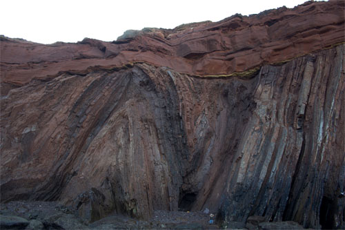
Angular unconformity at Telheiro Beach, Portugal (credit: Gabriela Bruno)
This image posted at Earth Science Picture of the Day would be hard to beat as the definitive angular unconformity. It shows Upper Carboniferous marine metagreywackes folded during the Variscan orogeny overlain by Triassic redbeds. Structurally it is uncannily similar to Hutton‘s famous unconformity at Siccar Point on the coast of SE Scotland, although the tight folding there is Caledonian in age and the unconformable redbeds are Devonian in age.
The early 21st century seems to have been plagued by very powerful earthquakes: 217 greater than Magnitude 7.0; 19 > Magnitude 8.0 and 2 >Magnitude 9.0. Although some lesser seismic events kill, those above M 7.0 have a far greater potential for fatal consequences. Over 700 thousand people have died from their effects: ~20 000 in the 2001 Gujarat earthquake (M 7.7); ~29 000 in 2003 Bam earthquake (M 6.6); ~250 000 in the 2004 Indian Ocean tsunami that stemmed from a M 9.1 earthquake off western Sumatra; ~95 000 in the 2005 Kashmir earthquake (M7.6); ~87 000 in the 2008 Sichuan earthquake (M 7.9); up to 316 000 in the 2010 Haiti earthquake (M 7.0); ~20 000 in the 2011 tsunami that hit NE Japan from the M 9.0 Tohoku earthquake. The 26 December 2004 Indian Ocean tsunamis spelled out the far-reaching risk to populated coastal areas that face oceans prone to seismicity or large coastal landslips, but also the need for warning systems: tsunamis travel far more slowly than seismic waves and , except for directly adjacent areas, there is good chance of escape given a timely alert. Yet, historically http://earthquake.usgs.gov/earthquakes/world/most_destructive.php, deadly risk is most often posed by earthquakes that occur beneath densely populated continental crust. Note that the most publicised earthquake that hit San Francisco in 1906 (at M 7.8) that lies on the world’s best-known fault, the San Andreas, caused between 700 and 3000 fatalities, a sizable proportion of which resulted from the subsequent fire. For continental earthquakes the biggest factor in deadly risk, outside of population density, is that of building standards.
A poor neighbourhood in Port au Prince, Haiti following the 2010 earthquake measuring >7 on the Richter scale. (credit: Wikipedia)
It barely needs stating that earthquakes are due to movement on faults, and these can leave distinct signs at or near to the surface, such as scarps, offsets of linear features such as roads, and broad rises or falls in the land surface. However, if they are due to faulting that does not break the surface – so-called ‘blind’ faults – very little record is left for geologists to analyse. But if it is possible to see actual breaks and shifts exposed by shallow excavations through geologically young materials, as in road cuts or trenches, then it is possible to work out an actual history of movements and their dimensions. It has also become increasingly possible to date the movements precisely using radiometric or luminescence means: a key element in establishing seismic risk is the historic frequency of events on active faults. Some of the most dangerous active faults are those at mountain fronts, such as the Himalaya and the American cordilleras, which often take the form of surface-breaking thrusts that are relative easy to analyse, although little work has been done to date. A notable study is on the West Andean Thrust that breaks cover east of Chile’s capital Santiago with a population of around 6 million (Vargas, G. Et al. 2014. Probing large intraplate earthquakes at the west flank of the Andes. Geology, v. 42, p. 1083-1086). This fault forms a prominent series of scarps in Santiago’s eastern suburbs, but for most of its length along the Andean Front it is ‘blind’. The last highly destructive on-shore earthquake in western South America was due to thrust movement that devastated the western Argentinean city of Mendoza in 1861. But the potential for large intraplate earthquakes is high along the entire west flank of the Andes.
Vargas and colleagues from France and the US excavated a 5 m deep trench through alluvium and colluvium over a distance of 25 m across one of the scarps associated with the San Ramon Thrust. They found excellent evidence of metre-sized displacement of some prominent units within the young sediments, sufficient to detect the effects of two distinct, major earthquakes, each producing horizontal shifts of up to 5 m. Individual sediment strata were dateable using radiocarbon and optically stimulated luminescence techniques. The earlier displacement occurred at around 17-19 ka and the second at about 8 ka. Various methods of estimation of the likely earthquake magnitudes of the displacements yielded values of about M 7.2 to 7.5 for both. That is quite sufficient for devastation of now nearby Santiago and, worryingly, another movement may be likely in the foreseeable future.
The “marching caterpillars” of the Basin and Range province, showing the San Andreas Fault in green (credit: University of Maryland, USA)
The Basin and Range province of the western US is one of the world’s largest products of continental extension. Being semi-arid, sedimentation has been unable to keep pace with crustal thinning thereby giving form to its name: linear mountain ridges separated by sediment-filled basins. Despite the extreme extension the Basin and Range has an average elevation of about 1400 m, although it is well below that of the Sierra Nevada range (2000+ m) that flanks it to the west. Throughout the Mesozoic, subduction towards the east beneath the North American plate produced voluminous magmas and fold-thrust belts adding to the continental crust in a manner similar to that still occurring in the South American Andes. Extension began in earnest during the Eocene (~45 Ma) and continues today. Much of the theory regarding continental extension – listric normal faults and detachments, fault-tilt blocks, core complexes etc. – stems from studies in this huge terrain. As regards the evolution of the Basin and Range, it has been widely thought that by the Late Oligocene (~25 Ma) the thickened Cordilleran crust had been reduced to a plateau no higher than the present Sierra Nevada, which subsequent extension reduced to the present Basin and Range.
The Eocene to Miocene extensional history was punctuated by huge episodes of explosive volcanism from which hot ash flowed laterally for hundreds of kilometres, relics of which are still widespread. Such ignimbrites are often very porous and were aquifers while still exposed, until buried by sediment and subsequent nuée ardent flows. Groundwater at the time of first exposure altered the volcanic glass shards from which ignimbrites are formed, so that the oxygen and hydrogen making up what was originally rainwater is now locked in the altered ash flows. The hydrogen isotopic composition of such meteoric water is known to vary with the altitude of the clouds shedding it. Water containing the heavier hydrogen isotope deuterium (D) is preferentially precipitated at low altitudes, so that high altitude rainfall is significantly depleted in it. Because of this the alteration can give clues to the former topographic elevation of the ignimbrites when they first rushed across the land surface. Applying this method to the repeated ignimbrite events in what is now the Basin and Range has given a good idea of the actual evolution of the land surface in the western US during the Palaeogene (Cassel, E.J. et al. 2014. Profile of a paleo-orogen: high topography across the present-day Basin and Range from 40-23 Ma. Geology, v. 42, p. 1007-1010).
The results present a major surprise. In the Eocene, elevation across the area was, as anticipated, a little more than the present Sierra Nevada (2000-2500 m). This fell back to roughly 2000 m, again as theory would suggest. But by the Late Oligocene (23-27 Ma) elevation expected to have declined further over the Basin and Range actually leapt to between 2500-3500 m, up to 2.1 km higher than it is today: the opposite of prediction. Effectively, despite evidence for Palaeogene extension the crust was buoyed-up probably by an upwelling of the asthenosphere and increased heat flow. The unexpected uplift occurred towards the end of subduction of oceanic lithosphere beneath western North America, the dynamics of which prevented the westward collapse of an earlier orogen. When subduction ended and the plate-margin tectonics became strike slip, as witnessed by the San Andreas Fault, the continental crust slid apart in the manner of books on a library shelf if a bookend is removed.
Related articles
Johnson, S.K. 2015. From rain to ranges. Scientific American, v. 312 (January 2015), p. 12-13.
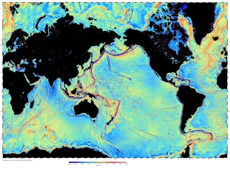
By far the least costly means of surveying the ocean floor on a global scale is the use of data remotely sensed from Earth orbit. That may sound absurd: how can it be possible to peer through thousands of metres of seawater? The answer comes from a practical application of lateral thinking. As well as being influenced by lunar and solar tidal attraction, sea level also depends on the Earth’s gravity field; that is, on the distribution of mass beneath the sea surface – how deep the water is and on varying density of rocks that lie beneath the sea floor. Water having a low density, the deeper it is the lower the overall gravitational attraction, and vice versa. Consequently, seawater is attracted towards shallower areas, standing high over, say, a seamount and low over the abyssal plains and trenches. Measuring sea-surface elevation defines the true shape that Earth would take if the entire surface was covered by water – the geoid – and is both a key to variations in gravity over the oceans and to bathymetry.
Radar altimeters can measure the average height of the sea surface to within a couple of centimetres: the roughness and tidal fluctuations are ‘ironed out’ by measurements every couple of weeks as the satellite passes on a regular orbital schedule. There is absolutely no way this systematic and highly accurate approach could be achieved by ship-borne bathymetric or gravity measurements, although such surveys help check the results from radar altimetry over widely spaced transects. Even after 40 years of accurate mapping with hundreds of ship-borne echo sounders 50% of the ocean floor is more than 10 km from such a depth measurement (80% lacks depth soundings)
This approach has been used since the first radar altimeter was placed in orbit on Seasat, launched in 1978, which revolutionised bathymetry and the details of plate tectonic features on the ocean floor. Since then, improvements in measurements of sea-surface elevation and the computer processing needed to extract the information from complex radar data have show more detail. The latest refinement stems from two satellites, NASA’s Jason-1(2001) and the European Space Agency’s Cryosat-2 (2010) (Sandwell, D.T. et al. 2014. New global marine gravity model from CryoSat-2 and Jason-1 reveals buried tectonic structure. Science, v. 346. p. 65-67; see also Hwang, C & Chang, E.T.Y. 2014. Seafloor secrets revealed. Science, v. 346. p. 32-33). If you have Google Earth you can view the marine gravity data by clicking here. The maps throw light on previously unknown tectonic features beneath the China Sea (large faults buried by sediments), the Gulf of Mexico (an extinct spreading centre) and the South Atlantic (a major propagating rift) as well as thousands of seamounts.
Global gravity over the oceans derived from Jason-1 and Cryosat-2 radar altimetry (credit: Scripps Institution of Oceanography)
There are many ways of processing the data, and so years of fruitful interpretation lie ahead of oceanographers and tectonicians, with more data likely from other suitably equipped satellites: sea-surface height studies are also essential in mapping changing surface currents, variations in water density and salinity, sea-ice thickness, eddies, superswells and changes due to processes linked to El Niño.
The lithosphere that falls into the mantle at subduction zones must end up somewhere in the deep Earth; the question is, where and what happens to it. There are hints from seismic tomography of the mantle that such slabs penetrate as deep as the boundary between the lowermost mantle and the molten outer core. The lithosphere’s two components, depleted mantle and oceanic crust, are compositionally quite different, being peridotitic and basaltic, so each is likely to be involved different petrological processes. As regards the physics, since seismic activity ceases below a depth of about 700 km neither entity behaves in a brittle fashion in the lower mantle. Such ductile materials might even pile up in the manner of intestines on the lithological equivalent of the abattoir floor; Bowels of the Earth as John Elder had it in his book of the same name.
Sketch of the lower 1000 km of the Earth’s mantle (credit: Williams, Q. 2014. Deep mantle matters. Science, v. 344, p. 800-801)
Pressure would make these recycled components mineralogically different, as indeed a relative light squeeze does in the upper mantle, where cold wet basalts become dry and denser eclogites thereby pulling more lithosphere down Wadati and Benioff’s eponymous zones to drive plate tectonics. Decades old experiments at lower-mantle pressures suggest that mantle minerals recompose from olivine with a dash of pyroxene to a mixture of more pressure-resistant iron-magnesium oxide and perovskite ((Mg,Fe)SiO3). Experiments in the early 21st century, under conditions at depths below 2600 km, revealed that perovskite transforms at the very bottom of the mantle (the D” zone) into layers of magnesium plus iron, silicon and oxygen. This is provisionally known as ‘post-perovskite’. The experiments showed that the transition releases heat. So, should oceanic lithosphere descend to the D” zone, it would receive an energy ‘kick’ and its temperature would increase. Conversely, if D”-zone materials rose to the depth of the perovskite to post-perovskite transition they would become less dense: a possible driver for deep-mantle plumes.
Now a new iron-rich phase stable in the bottom 1000 km of the mantle has emerged from experiments, seeming to result from perovskite undergoing a disproportionation reaction (Zhang, L. And 11 others 2014. Disproportionation of (Mg,Fe)SiO3 perovskite in Earth’s deep mantle. Science, v. 344, p. 877-882). In the same issue of Science other workers using laser-heated diamond anvils have revealed that, despite the huge pressures, basaltic rock may melt at temperatures considerably below the solid mantle’s ambient temperature (Andrault, D. et al. 2014. Melting of subducted basalt at the core-mantle boundary. Science, v. 344, p. 892-895). Both studies help better understand the peculiarities of the deepest mantle that emerge from seismic tomography (Williams, Q. 2014. Deep mantle matters. Science, v. 344, p. 800-801).
Huge blocks with reduced S-wave velocities that rise above the D” zone sit beneath Africa and the Pacific Ocean. There are also smaller zones at the core-mantle boundary (CMB) with shear-wave velocities up to 45% lower than expected. These ultralow-velocity zones (ULVZs) probably coincide with melting of subducted oceanic basalts, but the magma cannot escape by rising as it would soon revert to perovskite. Yet, since ultramafic compositions cannot melt under such high pressures the ULVSs indirectly show that subduction does descend to the CMB. Seismically defined horizontal layering in the D” zone thus may result from basaltic slabs whose ductility has enabled them to fold like sheets of lasagne as the reach the base of the mantle. Development of variants of the laser-heated diamond anvil set-up seem likely to offer insights into our own world’s ‘digestive’ system at a far lower cost and with vastly more relevance than the growing fad for speculating on Earth-like planets that the current ‘laws’ of physics show can never be visited and on ‘exobiology’ that cannot proceed further than the extremes of the Earth’s near-surface environment and the DNA double helix.
A large number of water-oriented tropes have been applied to Earth for ‘artistic effect’, ranging from Waterworld to the Blue Planet, but from a geoscientific perspective H2O in its many forms – liquid, solid, gas, supercritical fluid and chemically bound – has as much influence over the way the world works as do its internal heat production and transfer. Leaving aside surface processes, the presence of water has dramatic effects on the temperature at which rocks – felsic, mafic and ultramafic – begin to melt and deform and on the rates of important chemical reactions bound up with internal processes.
For a long while many geologists believed that the oceans were the product of water being transferred from the mantle by degassing through volcanoes so that the deep Earth has steadily been desiccated. But now it has become clear that such is the rate at which subduction can shift water back to the mantle that the entire volume of modern ocean water may have been cycled back and forth more than 3 times in Earth history (see Subduction and the water cycle). Besides, it is conceivable that accretion of cometary material up to about 3.8 Ga may have delivered the bulk of it.
An important aspect of the deep part of the water cycle concerns just how far into the mantle subduction can transport this most dominant volatile component of our planet. Ultra high-pressure experimental petrology has reached the stage when conditions at depths more than halfway to the core-mantle boundary (pressures up to 50 GPa) can be sustained using diamond anvils surrounding chemical mixtures that approximate mantle ultramafic materials. Previously, it was thought that serpentinite, the hydrous mineral most likely to be subducted, broke down into magnesium-rich, anhydrous silicates at around 1250 km down. This would prevent the deepest mantle from gaining any subducted water and retaining any that it had since the Earth formed. A team of Japanese geochemists has discovered a hint that hydrous silicates can, through a series of phase changes, achieve stability under the conditions of the deepest mantle (Nishi, M. 2014. Stability of hydrous silicate at high pressures and water transport to the deep lower mantle. Nature Geoscience, v. 7, p. 224-227). Their experiments yielded a yet unnamed mineral (phase H or MgSiH2O4) from approximate mantle composition that could remain stable in subducted slabs down to the core-mantle boundary. This development may help explain why the lowermost mantle is able to participate in plume activity through reduction in viscosity at those depths.
A parallel discovery concerns conditions at the base of the upper mantle; the 410 to 660 km mantle seismic transition zone. It comes from close study of a rare class of Brazilian diamonds that have been swiftly transported to the Earth’s surface from such depths, probably in kimberlite magma pipes, though their actual source rock has yet to be discovered. These ultra-deep diamonds prove to contain inclusions of mantle materials from the transition zone (Pearson, D.G. and 11 others 2014. Hydrous mantle transition zone indicated by ringwoodite included within diamond. Nature, v. 507, p. 221-224). Australian geochemist Ted Ringwood pioneered the idea in the 1950s and 60s that the mantle transition zone might be due to the main mantle mineral olivine ((Mg,Fe)2SiO4) being transformed to structures commensurate with extremely high pressures, including one akin to that of spinel. Such a mineral was first observed in stony meteorites that had undergone shock metamorphism, and was dubbed ringwoodite in honour of its eponymous predictor. Yet ringwoodite had never been found in terrestrial rocks, until it turned up in the Brazilian diamonds thanks to Pearson and colleagues.
Partial cross-section of the Earth showing the location of ringwoodite in the mantle Credit: Kathy Mather
Earlier experimental work to synthesise ultra-deep minerals discovered that ringwoodite may contain up to 2% water (actually OH groups) in its molecular lattice: an astonishing thing for material formed under such extreme conditions. The ringwoodite inclusions in diamond show infrared spectra that closely resemble its hydrous form. From this it may be inferred that the 401-660 km transition zone contains a vast amount of water; roughly the same as in all the oceans combined, though the find is yet to be confirmed in a wider selection of diamonds. One of the puzzles about diamondiferous kimberlites is that the magma must have been rich in water and carbon dioxide. That can now be explained by volatile-rich materials at the depths where diamonds form, But that does not necessarily implicate the whole transition zone: there may be pockets ripe for kimberlitic magma formation in a more widely water-poor mantle.
Related articles
Keppler, H. 2014. Earth’s deep water reservoir. Nature , v. 507, p. 174-175
Note: Earth-Pages will be closing as of early July, but will continue in another form atEarth-logs
For many geoscientists and lay people the water cycle is considered to be part of the Earth’s surface system. That is, the cycle of evapotranspiration, precipitation and infiltration involving atmosphere, oceans, cryosphere, terrestrial hydrology and groundwater. Yet it links to the mantle through subduction of hydrated oceanic lithosphere and volcanism. The rate at which water vapour re-enters the surface part of the water cycle through volcanoes is reasonably well understood, but the same cannot be said about ‘recharge’ of the mantle through subduction.
The water cycle as visualised by the US Geological Survey (credit: Wikipedia)
Subducted oceanic crust is old, cold and wet: fundamentals of plate theory. The slab-pull that largely drives plate tectonics results from phase transitions in oceanic crust that are part and parcel of low-temperature – high-pressure metamorphism. They involve the growth of the anhydrous minerals garnet and high-pressure pyroxene that constitute eclogite, the dense form taken by basalt that causes the density of subducted lithosphere to exceed that of mantle peridotite and so to sink. This transformation drives water out of subducted lithosphere into the mantle wedge overlying a subduction zone, where it encourages partial melting to produce volatile-rich andesitic basalt magma – the primary magma of island- and continental-arc igneous activity. Thus, most water that does reenter the mantle probably resides in the ultramafic lithospheric mantle in the form of hydrated olivine, i.e. the mineral serpentine, and that is hard to judge.
Water probably gets into the mantle lithosphere when the lithosphere bends to begin its descent. That is believed to involve faults – cold lithosphere is brittle – down which water can diffuse to hydrate ultramafic rocks. So the amount of water probably depends on the number of such bend-related faults. A way of assessing the degree of such faulting and thus the proportion of serpentinite is analysis of seismic records from subduction zones. This has been done from earthquake records from the West Pacific subduction zone descending beneath northern Japan (Garth, T. & Rietbrock, A. 2014. Order of magnitude increase in subducted H2O due to hydrated normal faults within the Wadati-Bennioff zone. Geology, on-line publication doi:10.1130/G34730.1). The results suggest that between 17 to 31% of the subducted mantle there has been serpentinised.
In a million years each kilometre along the length of this subduction zone would therefore transfer between 170 to 318 billion tonnes of water into the mantle; an estimate more than ten times previous estimates. The authors observe that at such a rate a subduction zone equivalent to the existing, 3400 km long Kuril and Izu-Bonin arcs that affect Japan would have transferred sufficient water to fill the present world oceans 3.5 times over the history of the Earth. Had the entire rate of modern subduction along a length of 55 thousand kilometres been maintained over 4.5 billion years, the world’s oceans would have been recycled through the mantle once every 80 million years. To put that in perspective, since the Cretaceous Chalk of southern England began to be deposited, the entire mass of ocean water has been renewed. Moreover, subduction has probably slowed considerably through time, so the transfer of water would have been at a greater pace in the more distant past.
A rough-and-ready way of assessing the rate at which silicic magmatic activity has varied through time is to separate out grains of zircon that have accumulated in sedimentary rocks of different ages. Zircon is readily datable using the U-Pb method, if you have access to mass spectrometry. While some of the zircons will date from much older continental crust that was exposed while the sediments originated, sometimes there are grains that formed only a few million years before the sediments accumulated. Those are likely to have crystallized from silica-rich volcanic rocks above subduction zones where ocean-floor has been driven beneath continental crust; i.e. at continental volcanic arcs. Such young zircons therefore help assess the tectonic conditions close to sedimentary basins. The potential of detrital zircon geochronology was first suggested to me by Dr M.V.N. Murthy of the Geological Survey of India in 1978, long before anyone could aspire to mass zircon dating. M.V.N. had by then amassed kilograms of zircon grains from every imaginable source in India, and may have been the first geologist to realise their potential. It has become a lot quicker and cheaper in the last two decades, thanks to methods of dating single zircon grains both precisely and accurately and M.V.N.’s prescient suggestion has been borne out globally.
A detrital zircon grain about 0.25 mm long. (Photo credit: Wikipedia)
Results for the late Precambrian to early Palaeozoic have recently been compiled (McKenzie, N.R. et al. 2014. Plate tectonic influences on Neoproterozoic-early Paleozoic climate and animal evolution. Geology, online publication doi:10.1130/G34962.1). One of the striking correlations is between the abundance of ‘young’ zircons relative to Cambrian sedimentary deposition and the pace of diversification of animal faunas during the Cambrian. During the Cambrian Period there may have been far more continental-margin arc volcanism than in the preceding late Neoproterozoic or later in the early Palaeozoic. That would match with evidence for the Cambrian atmosphere having reached the greatest CO2 concentration of Phanerozoic times and the fact that the Gondwana supercontinent (comprising the present southern continents plus India) was assembled at that time by collision of several Precambrian continental masses. Global temperatures must have been rising.
Earth at abround the start of the Cambrian showing the cratons that collided to form Gondwana (Photo credit: Wikipedia)
The rapid emergence of all the major animal groups by the middle Cambrian – the Cambrian Explosion – took place during and despite climatic warming. Environmental stress, perhaps increased calcium and bicarbonate ions in sea water as a result of acid conditions, may have forced animals to develop means of getting both ions out of their cells to form carbonate skeletons: the Cambrian Explosion really marks the first appearance of shelly faunas and a good chance of fossilisation. Yet at the peak of volcanically-induced warming faunal diversity, especially of reef-building animals, fell-off dramatically to create what some palaeobiologsts have termed the Cambrian ‘dead interval’. Marine life really took-off in a big way during the Ordovician while temperatures were falling globally; so much so that the close of the Ordovician was marked by the first major glaciation focused on Gondwana. The zircon record indicates that continental-arc volcanism also declined during the Ordovician, and maybe the Cambrian silicic volcanics were chemically weathered during that Period to remove carbon-dioxide from the atmosphere, along with renewed reef building to bury carbonate fossils.
The great Tohoku earthquake (moment magnitude 9.0) of 11 March 2011 beneath the Pacific Ocean off the largest Japanese island of Honshu resulted in the devastating tsunami that tore many kilometres inland along its northern coast line and affected the entire Pacific Basin (see NOAA animation of the tsunami’s propagation) .
Railway locomotive thrown aside by the 11 March 2011 Tsunami in Japan. (credit: Wikipedia)
This article can now be read in full at Earth-logs in the Geohazardsarchive for 2017
Tectonics on any rocky planet is an expression of the way heat is transferred from its deep interior to the surface to be lost by radiation to outer space. Radiative heat loss is vastly more efficient than either conduction or convection since the power emitted by a body is proportion to the fourth power of its absolute temperature. Unless it is superheated from outside by its star, a planet cannot stay molten at its surface for long because cooling by radiation releases all of the heat that makes its way to the surface. Any football supporter who has rushed to get a microwaved pie at half time will have learned this quickly: a cool crust can hide a damagingly hot centre.
Thermal power is delivered to a planet’s surface by convection deep down and conduction nearer the surface because rocks, both solid and molten, are almost opaque to radiation. The vigour of the outward flow of heat might seem to be related mainly to the amount of internal heat but it is also governed by limits imposed by temperature on the form of convection. Of the Inner Planets only Earth shows surface signs of deep convection in the form of plate tectonics driven mainly by the pull exerted by steep subduction of cool, dense slabs of old oceanic lithosphere. Only Jupiter’s moon Io shows comparable surface signs of inner dynamics, but in the form of immense volcanoes rather than lateral movements of slabs. Io has about 40 times the surface heat flow of Earth, thanks largely to huge tidal forces imposed by Jupiter. So it seems that a different mode of convection is needed to shift the tidal heat production; similar in many ways to Earth’s relatively puny and isolated hot spots and mantle plumes.
An analogy for the early Earth, Jupiter’s moon Io is speckled with large active volcanoes; signs of vigorous internal heat transport but not of plate tectonics. Its colour is dominated by various forms of sulfur rather than mafic igneous rocks. (credit: Wikipedia)
Shortly after Earth’s accretion it would have contained far more heat than now: gravitational energy of accretion itself; greater tidal heating from a close Moon and up to five times more from internal radioactive decay. The time at which plate tectonics can be deduced from evidence in ancient rocks has been disputed since the 1970s, but now an approach inspired by Io’s behaviour approaches the issue from the opposite direction: what might have been the mode of Earth’s heat transport shortly after accretion (Moore, W.B. & Webb, A.A.G. 2013. Heat-pipe Earth. Nature, v. 501, p. 501-505). The two American geophysicists modelled Rayleigh-Bénard convection – multicelled convection akin to that of the ‘heat pipes’ inside Io – for a range of possible thermal conditions in the Hadean. The modelled planet, dominated by volcanic centres turned out to have some surprising properties.
The sheer efficiency of heat-pipe dominated heat transfer and radiative heat lost results in development of a thick cold lithosphere between the pipes, that advects surface material downwards. Decreasing the heat sources results in a ‘flip’ to convection very like plate tectonics. In itself, this notion of sudden shift from Rayleigh-Bénard convection to plate tectonics is not new – several Archaean specialists, including me, debated this in the late 1970s – but the convincing modelling is. The authors also assemble a plausible list of evidence for it from the Archaean geological record: the presence in pre- 3.2 Ga greenstone belts of abundant ultramafic lavas marking high fractions of mantle melting; the dome-trough structure of granite-greenstone terrains; granitic magmas formed by melting of wet mafic rocks at around 45 km depth, extending back to second-hand evidence from Hadean zircons preserved in much younger rocks. They dwell on the oldest sizeable terranes in West Greenland (the Itsaq gneiss complex), South Africa and Western Australia (Barberton and the Pilbara) as a plausible and tangible products of ‘heat-pipe’ tectonics. They suggest that the transition to plate-tectonic dominance was around 3.2 Ga, yet ‘heat pipes’ remain to the present in the form of plumes so nicely defined in the preceding item Mantle structures beneath the central Pacific.
Since it first figured in Earth Pages 13 years ago seismic tomography has advanced steadily as regards the detail that can be shown and the level of confidence in its accuracy: in the early days some geoscientists considered the results to be verging on the imaginary. There were indeed deficiencies, one being that a mantle plume which everyone believed to be present beneath Hawaii didn’t show up on the first tomographic section through the central Pacific. Plumes are one of the forms likely to be taken by mantle heat convection, and many now believe that some of them emerge from great depths in the mantle, perhaps at its interface with the outer core.
The improvements in imaging deep structure stem mainly from increasingly sophisticated software and faster computers, the data being fed in being historic seismograph records from around the globe. The approach seeks out deviations in the speed of seismic waves from the mean at different depths beneath the Earth’s surface. Decreases suggest lower strength and therefore hotter rocks while abnormally high speeds signify strong, cool parts of the mantle. The hotter mantle rock is the lower its density and the more likely it is to be rising, and vice versa.
Using state-of-the-art tomography to probe beneath the central Pacific is a natural strategy as the region contains a greater concentration of hot-spot related volcanic island chains than anywhere else and that is the focus of a US-French group of collaborators (French, S. et al. 2013. Waveform tomography reveals channeled flow at the base of the oceanic lithosphere. Science, v. 342, 227-230; doi 10.1126/science.1241514). The authors first note the appearance on 2-D global maps for a depth of 250 km of elongate zones of low shear-strength mantle that approximately parallel the known directions of local absolute plate movement. The most clear of these occur beneath the Pacific hemisphere, strongly suggesting some kind of channelling of hot material by convection away from the East Pacific Rise.
Seismic tomographic model of the mantle beneath the central Pacific. Yellow to red colours represent increasingly low shear strength. (credit: Global Seismology Group / Berkeley Seismological Laboratory)
Visually it is the three-dimensional models of the Pacific hot-spot ‘swarm’ that grab attention. These show the low velocity zone of the asthenosphere at depths of around 50 to 100 km, as predicted but with odd convolutions. Down to 1000 km is a zone of complexity with limb-like lobes of warm, low-strength mantle concentrated beneath the main island chains. That beneath the Hawaiian hot spot definitely has a plume-like shape but one curiously bent at depth, turning to the NW as it emerges from even deeper mantle then taking a knee-like bend to the east . Those beneath the hot spots of the west Pacific are more irregular but almost vertical. Just what kind of process the peculiarities represent in detail is not known, but it is almost certainly a reflection of complex forms taken by convection in a highly viscous medium.
Over a period of about 300 Ma the fragmentation of a supercontinent, Rodinia, drove a round of sea-floor spreading and continental drift that culminated in reassembly of the older continental pieces and entirely new crust in a new supercontinent, Gondwana. The largest source of evidence for this remarkable tectonic turnaround is a belt stretching N-S for over 3000 km from southern Israel through East Africa to Mozambique. At its widest the belt exposes Neoproterozoic rocks and structures for some 1700 km E-W from west of the Nile in northern Sudan almost to Riyadh in Saudi Arabia. This Arabian-Nubian Shield tapers southwards to thin out completely in northern Tanzania between far older cratons and in a state of high-grade metamorphism.
This East African Orogen has long been considered the best exposed bowels of former mountain building that there are: results of continent-continent collision and the bulldozing together of many oceanic arcs and remnants of oceanic lithosphere that once separated the cratons. This was much more complex than a case of head-on tectonics, the northward-swelling Arabian-Nubian Shield showing all the signs of being like a gigantic ‘pip’ squeezed out northwards from two cratonic jaws during the last stages of what is often called the Pan African Orogeny. Interestingly, the line of the orogen is roughly followed by East Africa’s other giant feature, the Rift Valley; actually two of them following Pan African terranes. A continental scale anisotropy has been reactivated and subject to extensional tectonics, and maybe in future a new round of sea-floor spreading as has begun in the Red Sea, some half a billion years after it formed.
Simplified geological map of the East African Orogen courtesy of the authors of Fritz et al 2013
Now there is an opportunity for anyone to download and read a digest of East African orogenic processes compiled by researchers from several countries along the belt and their colleagues from North America, Europe and Australia who have been privileged to work in this vast area (Fritz, H and 13 others 2013. Orogen styles in the East African orogen: A review of the Neoproterozoic to Cambrian tectonic evolution. Journal of African Earth Sciences, v. 86, p. 65-106 Click on the link, scroll to the Open Access article to download the 12 Mb PDF version). The authors present superb simplified geological maps of each major part of the orogen, a vast array of references and well-written accounts of its sector-by-sector tectonic and metamorphic evolution, variations in style and broad tectonic setting.
In its 125th year the Geological Society of America is publishing invited reviews of central geoscience topics in its Bulletin. They seem potentially useful for both undergraduate students and researchers as accounts of the ‘state-of-the-art’ and compendia of references. The latest focuses on major controls on past sea-level changes by processes that operate in the solid Earth (Conrad, C.P. 2013. The solid Earth’s influence on sea level. Geological Society of America Bulletin, v. 125, p. 1027-1052), a retrospective look at how geoscientists have understood large igneous provinces (Bryan, S. E. & Ferrari, L. 2013. Large igneous provinces and silicic large igneous provinces: Progress in our understanding over the last 25 years. Geological Society of America Bulletin, v. 125, p. 1053-1078) and the perennial topic of how granites form and end up in intrusions (Brown, M. 2013. Granite: From genesis to emplacement Geological Society of America Bulletin, v. 125, p. 1079-1113).
Sea level change
Conrad covers sea-level changes on the short- (1 to 100 years), medium- (1 to 100 ka) and long term (1 to 100 Ma). The first two mainly result from local deformation of different kinds associated with glacial loading and unloading. These result in changes in the land surface, the sea surface nearby and on thousand year to 100 ka timescales to ups and downs of the sea-bed. Global sea-level changes due to melting of continental glaciers at the present day amount to about half the estimated 2 to 3 mm of rise each year. But increasingly sensitive measures show it is more complex as the rapid shifts of mass involved in melting ice also result in effects on the solid Earth. At present solid mass is being transferred polewards, but at rates that differ in Northern and Southern hemispheres and which are changing with anthropogenic influences on glacial melting. Viscous movement of the solid Earth is so slow that effects from previous glacial-interglacial episodes continue today. As a result rapid elastic movements are tending to produce relative sea-level falls in polar regions of up to 20 mm per year with rising sea level focusing on areas between 30°N and 30°S. The influence of the slower viscous mass transfer has an opposite sense: sea-level rise at high latitudes. Understanding the short- and medium-term controls is vital in predicting issues arising in the near future from natural and anthropogenic change.
Comparison of two sea level reconstructions during the last 500 Ma. (credit: Wikipedia)
Most geologists are concerned in practice with explanations for major sea-level changes in the distant past, which have a great deal to do with changes in the volumes of the ocean basins. If the global sea-floor rises on average water is displaced onto former land to produce transgressions, and subsidence of the sea floor draws water down from the land. Conrad gives a detailed account of what has been going on since the start of the Cretaceous Period, based on the rate of sea-floor spreading, marine volcanism and sedimentation, changes in the area of the ocean basins and the effects of thermally-induced uplift and subsidence of the continents, showing how each contribution acted cumulatively to give the vast transgressions and regressions that affected the late Phanerozoic. On the even longer timescale of opening and closing of oceans and the building and disintegration of supercontinents the entire mantle becomes involved in controls on sea level and a significant amount of water is chemically exchanged with the mantle.
Large igneous provinces
The Web of Science database marks the first appearance in print of “large igneous province” in 1993, so here is a topic that is indeed new, although the single-most important attribute of LIPs, ‘flood basalt’ pops up three decades earlier and the term ‘trap’ that describes their stepped topography is more than a century old. Bryan and Ferrari are therefore charting progress in an exciting new field, yet one that no human – or hominin for that matter – has ever witnessed in action. One develops, on average, every 20 Ma and since they are of geologically short duration long periods pass with little sign of one of the worst things that our planet can do to the biosphere. In the last quarter century it has emerged that they blurt out the products of energy and matter transported as rising plumes from the depths of the mantle; they, but not all, have played roles in mass extinctions; unsuspected reserves of precious metals occur in them; they play some role in the formation of sedimentary basins and maturation of petroleum and it seems other planets have them – a recipe for attention in the early 21st century. Whatever, Bryan and Ferrari provide a mine of geological entertainment.
In comparison, granites have always been part of the geologist’s canon, a perennial source of controversy and celebrated by major works every decade, or so it seems, with twenty thousand ‘hits’ on Web of Science since 1900 (WoS only goes back that far). Since the resolution of the plutonist-neptunist wrangling over granite’s origin one topic that has been returned to again and again is how and where did the melting to form granitic magma take place? If indeed granites did form by melting and not as a result of ‘granitisation. Lions of the science worried at these issues up to the mid 20th century: Bowen, Tuttle, Read, Buddington, Barth and many others are largely forgotten actors, except for the credit in such works as that of Michael Brown. Experimental melting under changing pressure and temperature, partial pressures of water, CO2 and oxygen still go on, using different parent rocks. One long-considered possibility has more or less disappeared: fractional crystallisation from more mafic magma might apply to other silicic plutonic rocks helpfully described as ‘granitic’ or called ‘granitoids’, but granite (sensu stricto) has a specific geochemical and mineralogical niche to which Brown largely adheres. For a while in the last 40 years classification got somewhat out of hand, moving from a mineralogical base to one oriented geochemically: what Brown refers to as the period of ‘Alphabet Granites’ with I-, S- A- and other-type granites. Evidence for the dominance of partial melting of pre-existing continental crust has won-out, and branched into the style, conditions and heat-source of melting.
Typical granite tor near Kisumu, Kenya (credit: Wikipedia)
All agree that magmas of granitic composition are extremely sticky. The chemical underpinnings for that and basalt magma’s relatively high fluidity were established by physical chemist Bernhardt Patrick John O’Mara Bockris (1923-2013) but barely referred to, even by Michael Brown. Yet that high viscosity has always posed a problem for the coalescence of small percentages of melt into the vast blobs of low density liquid able to rise from the deep crust to the upper crust. Here are four revealing pages and ten more on how substantial granite bodies are able to ascend, signs that the puzzle is steadily being resolved. Partial melting implies changes in the ability of the continental crust to deform when stressed, and this is one of the topics on which Brown closes his discussion, ending, of course, on a ‘work in progress’ note that has been there since the days of Hutton and Playfair.
The extremely hazardous seaway through the Straits of Gibraltar and the waterless deserts of the Levant presented considerable barriers to natural exchange of animal groups between Africa and Eurasia throughout the period of hominin evolution known from the African Pliocene and Pleistocene record. These barriers were breached by hominins only occasionally. Through most of the Miocene and back to the Mesozoic Era Iberia and what is now Morocco were separated by a wide seaway preventing faunal exchange. That Betic Seaway eventually closed with the tectonic collision of the two sides to form the modern Betic Cordillera in southern Spain towards the end of the Miocene. This left parts of the Mediterranean to evaporate during what is known as the Messinian Salinity Crisis, which reached completion at 5.59 Ma. Yet this Europe-Africa connection was short-lived, being breached by what is regarded as one of the most dramatic events in Cenozoic history: the Zanclean Flood. At 5.33 Ma the Atlantic burst through what is now the Straits of Gibraltar to refill the Mediterranean Basin within a period between a few months and two years. The flooding began as a vast system of rapids some 1 km high with an estimated flow a thousand times that of the modern Amazon.
Strait of Gibraltar from space, with Spain on the left and Morocco on the right.) (credit: Wikipedia)
During the existence of the Europe-Africa land bridge it was possible for animals to move between north-west Africa and western Europe. Evidence that such an exchange did take place comes from a number of Late Miocene localities in southern Spain and North Africa. The first recorded migrants into Spain were African gerbils, then evidence mounted for larger animals, including hippos and early camels moving into Europe and a reverse migration of rabbits and mice. One of the Spanish sites (Gibert, L. et al. 2013. Evidence for an African-Iberian mammal dispersal during the pre-evaporitic Messinian. Geology, v. 41, p. 691-694) has allowed precise magnetostratigraphic dates to be put on the migrations. The Spanish-US team suggests conditions ripe for migration were in three distinct phases: around 6.3 Ma when hippos managed to swim to Europe; around 6.2 Ma which saw European small mammals making the journey south and camels moving to Europe; in a 300 ka window of opportunity from 5.6 to 5.3 Ma for African mice to make the journey into Europe. Several distinct episodes probably reflect some ups and downs of sea level related to glacial retreats and advances in Antarctica.
One implication of the short-lived Messinian land bridge is that it may have been followed by primates, though evidence has yet to be found. A particularly interesting genus, suggested by some as a possible common ancestor for hominins and chimpanzees, is Oreopithecus a bipedal ape recorded from the Miocene of Italy
The Afar Depression of Ethiopia and Eritrea is a feature of tectonic serendipity. It is unique in showing on land the extensional processes and related volcanism that presage sea-floor spreading. Indeed it hosts three rift systems and a triple junction between the existing Red Sea and Gulf of Aden spreading centres and the East African Rift System that shows signs of future spalling of Somalia from Africa. Afar has been a focus of geoscientific attention since the earliest days of plate theory but practical interest has grown rapidly over the last decade or so when the area has become significantly more secure and safe to visit. Two recent studies seem to have overturned one of the most enduring assumptions about what drives this epitome of continental break-up.
Simulated perspective view of the Afar depression from the south (credit: Wikipedia)
From the obvious thermal activity deep below Afar, linked with volcanism and high heat flow, a mantle host spot and rising plume of deep mantle has been central to ideas on the tectonics of the area. A means of testing this hypothesis is the use of seismic data to assess the ductility and temperature structure of deep mantle through a form of tomography. The closer the spacing of seismic recording stations and the more sensitive the seismometers are the better the resolution of mantle structure. Afar now boasts one of the densest seismometer networks, rivalling the Earthscope USArray. http://earth-pages.co.uk/2009/11/01/the-march-of-the-seismometers/ and it is paying dividends (Hammond, J.O.S. and 10 others 2013. Mantle upwelling and initiation of rift segmentation beneath the Afar Depression. Geology, v. 41, p.635-638). The study brought together geoscientists from Britain, the US, Ethiopia, Eritrea and Botswana, who used data from 244 seismic stations in the Horn of Africa to probe depths down to 400 km with a resolution of about 50 km.
The tomographic images show no clear sign of the kind of narrow plume generally aasociated with the notion of a ‘hot spot’. Instead they pick out shallow (~75 km depth) P- and S-wave low-velocity features that follow the axes of the three active rift systems. The features coalesce at depth; in some respects the opposite of a classic plume that has a narrow ‘stem’ that swells upwards to form a broad ‘head’. If there ever was an Afar Plume it no longer functions. Instead, the rifts and associated lithospheric thinning are associated with a mantle upwelling that is being emplaced passively in the space made available by extensional tectonics. This is closely similar to what goes on beneath active and well-established mid-ocean spreading centres where de-pressuring of the rising mantle results in partial melting and basaltic magmatism along the rift system. Perhaps this is a sign that full sea-floor spreading in Afar is imminent, at least on geological timescales.
Simplified geologic map of the Afar Depression. (credit: Wikipedia after Beyene and Abdelsalam (2005))
For once, mantle geochemists and geophysicists have data that support a common hypothesis (Ferguson, D.J. and 8 others 2013. Melting during late-stage rifting in Afar is hot and deep. Nature, v. 499, p. 70-73). This US-British-Ethiopian team compares the trace element geochemistry of Recent basaltic lavas erupted along the axis of the Afar rift that links with the Red Sea spreading centre with equally young lavas from volcanoes some 20 km from the axis. Both sets of lavas are a great deal more enriched in incompatible trace elements that are generally enriched in melt compare with source than are ocean-floor basalts sampled from the mid-Red Sea rift. Modelling rare-earth element patterns in particular suggests that partial melting is going on at depths where garnet is stable in the mantle instead of spinel. This suggests that a strong layer, about 85 km down in the upper mantle is beginning to melt – magmas formed by small degrees of partial melting generally contain higher amounts of incompatible trace elements than do the products of more extensive melting. Estimates of the temperature of melting from lavas extruded at the rift axis than off-axis are significantly higher than expected at this depth suggesting that deeper mantle is rising faster than it can lose heat.
The depth of melting tallies with the thermal feature picked out by seismic tomography. The two teams converge on passively induced upwelling of hot asthenosphere while the Afar lithosphere is slowly being extended. The degree of melting beneath Afar is low at present, so that to become like mid-ocean ridge basalts a surge in the fraction of melting is needed. That would happen if the strong mantle layer fails plastically so that more asthenosphere can rise higher by passive means. The geochemists persist in an appeal to an Afar Plume for the 30 Ma old flood basalts that plaster much of the continental crust outside Afar. Those plateau-forming lavas, however, are little different in their trace element geochemistry from off-axis Afar basalts. Yet they are not obviously associated with an earlier episode of lithospheric extension and passive mantle upwelling. Most geologists who have studied the flood basalts would agree that they preceded the onset of rifting but have little idea of the actual processes that went on during that mid-Oligocene volcanic cataclysm.
For half a century the Earth’s planetary dynamism – plate movements, mantle convection and so on – has been ascribed to its abundance of water. Experiments on the ductility of quartz seemed to show that it became much weaker under hydrous conditions, and that was assumed to hold for all common silicates, a view backed up by experiments that deformed minerals under varying conditions. It was widely believed that even a few parts per million in a rock at depth would weaken it by orders of magnitude, a view that increasingly dominated theoretical tectonics on scales up to the whole lithosphere and at different mantle depths. Strangely, the founding assertion was not followed up with more detailed and sophisticated work until the last year or so. Though rarely seen in bulk, the dominant mineral in the mantle is olivine and that is likely to be a major control over ductility at depth, in plumes and other kinds of convection.
Peridotite xenoliths —olivines are light green crystals, pyroxenes are darker. (credit: Wikipedia)
Experimental work at the temperatures and pressures of the mantle has never been easy, and that becomes worse the more realistic the mineral composition of the materials being investigated. High-T, high-P research tends to focus on as few variables as possible: one mineral and one variable other than P and T is the norm. This applies to the latest research (Fei, H. et al. 2013. Small effect of water on upper mantle rheology based on silicon self-diffusion coefficients. Nature, v. 498, p. 213-215) but the measurements are of the rate at which silicon atoms diffuse through olivine molecules rather than direct measurements of strain. The justification for this approach is that one of the dominant processes involved in plastic deformation is a form of structural creep in which atoms diffuse through molecules in response to stress – the other is ‘dislocation creep’ achieved by the migration of structural defects in the atomic lattice.
Contrary to all expectations, changing the availability of water by 4 to 5 orders of magnitude changed silicon diffusion by no more than one order. If confirmed this presents major puzzles concerning Earth’s mantle and lithosphere dynamics. For instance, the weak zone of the asthenosphere cannot be a response to water and nor can the relative immobility of hotspots. Confirmation is absolutely central, in the sense of repeating Fei et al.’s experiments and also extending the methods to other olivine compositions – magnesium-rich forsterite was used, whereas natural olivines are solid solutions of Mg- and Fe-rich end members – and to materials more representative of the mantle, e.g. olivine plus pyroxene as a minimum (Brodholt, J. 2013. Water may be a damp squib. Nature, v. 498, p. 18-182)
Mass extinctions and smaller but significant die-offs in the marine and terrestrial domains have been linked in the geoscientific imagination with many things: asteroid impacts; gamma-ray bursts from distant supernovae; belches of methane from the sea floor; emissions of hydrogen sulfide gas from seawater itself during ocean anoxia events; sea-level changes and more. The most intriguing, since it suggests a causal link between the core-mantle boundary and the biosphere, is the influence of flood basalt events and the gases, both greenhouse and toxic, that they undoubtedly released.
The famous K-T extinction (now K-Pg since the Palaeogene became the Period following the Cretaceous rather than the Tertiary) has swayed back and forth between the Chicxulub impact in Mexico’s Yucatán Peninsula and the flood basalts of the Deccan Traps in western India as likely mechanisms, Chicxulub currently being in pole position. The equally devastating event at the close of the Triassic (at 201 Ma) that presaged the rise of the dinosaurs has had a similar external versus internal causality controversy, both the Rochechouarte crater and the Central Atlantic Magmatic Province being candidates.
CAMP flood basalts in Morocco (credit: Wikipedia)
Rochechouarte, however, was nowhere near as energetic an event as the Chicxulub impact. The problem is, as with all events for which the weight of evidence points to very short time scales – of the order of tens to hundreds of thousand years, is the dating of candidate causes. Rochechouarte happened at 201±2 Ma: it may or may not have coincided with faunal change. Yet timing of the CAMP flood basalts has hitherto been even more coarsely tagged. This imprecision is not unconnected with the choice of radiometric dating methods, the 40Ar/39Ar approach being ‘easy’ and hence popular, but limited in its precision and accuracy. The ‘gold standard’ is zircon U-Pb geochronology that depends on the far greater reluctance of the host mineral to lose either parent or daughter isotopes compared with the feldspars, micas and amphiboles used in many other methods. Zircon still in its igneous parent is crucial: it is so durable that vastly older zircons are often found in sediments. Yet basalts contain few zircons.
Zircon crystal under the microsope; length about 250 µm. (Photo credit: Wikipedia)
Zircon geochronology has now emerged from the CAMP flood basalts of eastern Canada, the Atlantic seaboard of the US and that of Morocco, which has a precision of around 30 ka, one to two orders of magnitude better than other methods (Blackburn, T.J. and 8 others 2013. Zircon U-Pb geochronology links the end-Triassic extinction with the Central Atlantic Magmatic Province. Science, v. 340, p. 941-945). The extinction is defined most readily by a sudden change in fossil pollen and spores, possibly within less than 10 ka, as well as extinction of Triassic marine fauna and large numbers of terrestrial reptile and amphibian taxa followed by diversification of early Jurassic dinosaurs. The oldest CAMP basalts are from Morocco immediately above spores of clearly Triassic age; i.e. before the extinction, whereas the basalt flows in Canada and the eastern US (a mere 3 to 13 ka younger)are above the turnover. So, the start of the CAMP flood volcanism brackets the extinction.
But did CAMP cause, indeed could it have caused the extinction? Blackburn and colleagues cannot be certain. A negative carbon-isotope spike associated with the extinction is estimated to have required almost a million km3 of magma to have been erupted almost instantaneously to inject excess CO2 into the atmosphere. The dating suggests four major pulses of eruption in the areas studied spread over around 600 ka, the last three being associated with biological diversification and recovery in the earliest Jurassic. In fact the research seems merely to suggest strongly that flood volcanism accompanied the extinction, but leaves its causing the death toll still an open question.
The CAMP events marked the beginning of Pangaea’s break-up and the formation of Tethys separating Eurasia and North America from the old Gondwana continental mass. That tropical seaway became the site of massive production of marine carbonates, presumably to draw down any carbon dioxide excess in the atmosphere.
Way back in the mists of time, say around 1970-71, an idea was doing the rounds that because the thermal conductivity of continental crust is lower than that of the ocean floor it should allow thermal energy to build up in the mantle beneath. In turn that might somehow encourage the formation of hot spots and a shallower depth to the asthenosphere: the outcome might be to encourage rifting of weakened lithosphere and ultimately a new round of sea-floor spreading. The case often cited was the Atlantic – North and South – since there are eight hotspots currently on the mid-Atlantic ridge. Africa was another popularised case with a great many broad domes associated with Cenozoic volcanism, and the link between formation of the East African Rift System, hot spots and doming had already been suggested. Africa has barely drifted for around 100 Ma and the domes were supposed to have formed by the build up of heat in the mantle beneath. Geoscience moved on to clearly demonstrate the coincidence of large igneous provinces and flood basalt volcanism with the initiation of Atlantic spreading in the form of the Central Atlantic and Brito-Arctic LIPs during initial opening of the South and North Atlantic at the end of the Triassic and during the Palaeocene respectively. But the role of continental insulation became a bit of backwater compared with notions of mantle plumes emanating at the core-mantle boundary. Well, it’s back.
The Mid-Atlantic Ridge (credit: Wikipedia)
There is now a vast repository of ocean-floor lavas that formed at mid-ocean ridges in the past, thanks to the international Deep Sea and Ocean Drilling Programmes begun in 1968 about when the heyday of plate tectonics really got underway. In the last 45 years there have also been great advances in igneous geochemistry and its interpretation, including relations with mantle melting temperatures. Geochemists at the Friedrich-Alexander-Universiteit in Erlangen, Germany have re-examined the major-element geochemistry of 184 glassy ocean-floor basalts from drill sites of different ages on the floor of the Atlantic Ocean and compared them with 157 from the Pacific. To avoid the possible influence of plume-related heating, the sites were chosen well away from the tracks of existing hot spots. Mantle temperature can be assessed from the sodium and iron content of basalts, Na decreasing with higher temperatures and Fe doing the reverse (Brandl, P.A. et al. 2013. High mantle temperatures following rifting cause by continental insulation. Nature Geoscience, v. 6, p. 391-394). Atlantic samples show increasing Na and decreasing Fe contents in progressively younger basalts, i.e. a trend with time of decreasing mantle temperature such that the oldest (~166 Ma) record 150°C higher mantle temperature than the youngest, with a similar result for the Indian Ocean floor. No such trend is present in samples from the same age range of the Pacific Ocean floor. At around 170 Ma the mid-Atlantic Ridge was close to the continental lithosphere of the Americas and Africa, whereas the East Pacific Rise was at least 2000 km from any continental margin. Younger Atlantic samples formed progressively further from its shores record cooling of the mantle source.
A prediction of the model is that the converse, continental accretion to form supercontinents such as Pangaea, should rapidly have caused considerable warming in the mantle beneath them. This suggests that the formation of supercontinents, or even less substantial continents, should carry the seeds of their re-fragmentation, as Africa is currently demonstrating by the separation of Arabia since the Red Sea began to open some 15 Ma ago, which Somalia and much of eastern Kenya and Tanzania seem destined to follow once the East African Rift System ‘gets steam up’.
Related articles
Langmuir, C. 2013. Older and hotter. Nature Geoscience, v. 6, p. 332-333
One of the key areas for unravelling the range of tectonic processes involved in the assembly of continents lies in the Western Cordillera of North America, made up of dozens of slivers of mutually exotic terranes. Their exposed upper parts remain largely intact and are dateable using fossils or radiometric dating. Through assiduous palaeomagnetic research it is sometimes possible to chart their motions over time to see the manner in which they approached and collided with one another. Geoscientists are now able to link such a complex process with underlying tectonics, not by inference but through direct seismological observation of the remains of subducted slabs in the mantle deep beneath.
The crumpled Farallon Plate beneath North America, colours showing different depths in the mantle (credit: Karin Sigloch)
This item can be read in full at Earth-logs in the Tectonics archive for 2013
Historical seismicity across the Sunda trench(credit: Wikipedia)
Few people will fail to remember the Indian Ocean tsunamis of 26 December 2004 because of their quarter-million death toll. The earthquake responsible for them resulted from thrusting movements on the subduction zone where part of the India-Australia plate descends beneath Sumatra. There have been some equally large but far less devastating events and many lesser earthquakes in the same region since. Some have been on the massive Wadati-Benioff zone but many, including two with magnitudes >8 in April 2012, have occurred well off the known plate boundary. Oddly, those two had strike-slip motions and were the largest such events since seismic records have been kept. Such motions where masses of lithosphere move past one another laterally can be devastating on land, yet offshore ones rarely cause tsunamis, for a simple reason: they neither lift nor drop parts of the ocean floor. So, to the world at large, both events went unreported.
To geophysicists, however, they were revealing oddities, for there is no bathymetric sign of an active sea-floor strike-slip fault. But there is a series of linear gravity anomalies running roughly N-S thought to represent transform faults that were thought to have shut down about 45 Ma ago (Delescluse, M. et al. 2012. April 2012 intra-oceanic seismicity off Sumatra boosted by the Banda-Aceh megathrust. Nature (on-line 27 September issue) doi:10.1038/nature11520). Examining the post-December 2004 seismic record of the area the authors noted a flurry of lesser events, mostly in the vicinity of the long dead fracture zones. Their analysis leads them to suggest not only that the Banda-Aceh earthquake and others along the Sumatran subduction zone reactivated the old strike-slip faults but that differences in the motion of the India-Australia plate continually stress the lithosphere. Indian continental crust is resisting subduction beneath the Himalaya thereby slowing plate movement in its wake. Ocean lithosphere north of Australia slides more easily down the subduction zone, so its northward motion is substantially faster, creating a torque in the region affected by the strike-slip motions. Ultimately, it is thought, this will split the plate into separate Indian and Australian plates.
Another surprising outcome of this complex seismic linkage in the far-east of the Indian Ocean is that the April strike-slip earthquake set the Earth ringing. For six days afterwards there was a five-fold increase in events of magnitudes greater than 5.5 more than 1500 km away, including some of around magnitude 7.0 (Polliitz, F.F. et al. 2012. The 11 April 2012 east Indian Ocean earthquake triggered large aftershocks worldwide. Nature (on-line 27 September issue) doi:10.1038/nature11504). Although distant minor shocks often follow large earthquakes, this is the first time that a swarm of magnitude 5.5 and greater has been noticed.
The Iapetus Ocean separating the paleocontinents of Baltica, Laurentia and Avalonia about 460 million years ago. (Rob Blakey http://jan.ucc.nau.edu/~rcb7/, Wikipedia)
The first sign that there was something odd about the Lower Palaeozoic in NW Europe and North America stemmed from gross mismatches between fossil assemblages only a few tens of kilometers apart across the regional strike of sedimentary rocks older than the Upper Silurian. It didn’t show up in the Devonian and Carboniferous, and nothing like it reappeared until well into the Jurassic. Until the 1960s the separation of these faunal provinces was ascribed to something akin to the Wallace Line that currently separates the flora and fauna of Oceania, Australia and the eastern islands of Indonesia from those of western Indonesia and Asia: a barrier to migration presented by the deep-water but narrow channel between Bali and Lombok in the Indonesian archipelago. The ancient biological boundary roughly coincides with the long-described Caledonian and Acadian Orogens of NW Europe and eastern North America respectively. With the discovery of plate tectonics another explanation arose: that formerly the opposite sides of the once contiguous orogens had been separated by thousands of kilometers across a former ocean. This was named in 1966 by John Tuzo Wilson after Iapetus , one of the mythical Greek titans who fathered Atlas – the eponym of the Atlantic Ocean. So, in the tectonic canon, the Caledonian-Acadian mountain belt marks the closure through subduction of its former oceanic lithosphere which brought the distinct faunal provinces together across a line known as the Iapetus Suture. Many lines of evidence time-stamp this continental collision to the end of the Silurian Period.
The Iapetus Suture, marked by the Niarbyl Fault on the Isle of Man. One of few places one can believably straddle two ancient continents. (G.J Kingsley at Wikipedia)
When the Iapetus Ocean began to open is not so easy to pin-point, save that it predated the Cambrian Period. The most likely possibility is that it marked the line of separation between fragments of the 1 billion-year old Rodinia supercontinent, which started to break up in the early Neoproterozoic. That was a protracted event, palaeomagnetic, radiometric and stratigraphic data loosely constraining extension between the former two sides of Iapetus to between 620 and 570 Ma. Around Quebec City, Canada are a number of large faults in the St Lawrence rift system that bound a zone of deep water sediments and volcanic rocks that yielded this broad age range. Yet the faults are associated with glassy rocks formed by frictional melting during brittle fracturing. These pseudotachylites can be dated, and have now helped resolve the ‘fuzziness’ of Iapetus’s formation (O’Brien, T.M. & van der Pluijm, B.A. 2012. Timing of Iapetus Ocean rifting from Ar geochronology of pseudotachylites in the St Lawrence rift system of southern Quebec. Geology, v. 40, p. 443-446). The two co-workers from the University of Michigan show that the rifting occurred between 613 and 614 Ma, coinciding with a brief period of mafic dyke emplacement in Newfoundland and Labrador. Since the Iapetus Suture occurs not far away from the St Lawrence rift system in eastern Canada the area has now become the best constrained example of what soon became known in the early days of plate tectonics as a Wilson Cycle, representing rift, drift and collision. John Tuzo Wilson (1908-1993), a Canadian descended from French and Scottish settlers, and a pioneer of the modern phase of geology, would be pleased it had finally homed in on terrain he knew well.
Archaean gneisses from West Greenland (Photo credit: Wikipedia)
When continents first appeared; the pace at which they grew; the tectonic and magmatic processes responsible for continental crust, and whether or not crustal material is consumed by the mantle to any great extent have been tough issues for geologists and geochemists to ponder on for the last four decades. Clearly, continental material was rare if not absent in the earliest days of the solid Earth, otherwise Hadean crust should have been found by now. Despite the hints at some differentiated, high silica rocks that may have hosted >4 billion-year old zircon crystals from much younger sediments, the oldest tangible crust – the Acasta Gneiss of northern Canada – just breaks the 4 Ga barrier: half a billion years short of the known age of the Earth (http://earth-pages.co.uk/2008/11/01/at-last-4-0-ga-barrier-broken/). Radiometric ages for crustal rocks steadily accumulated following what was in the early 1970s the astonishing discovery by Stephen Moorbath and colleagues at Oxford University and the Geological Survey of Greenland of a 3.8 billion year age for gneisses from West Greenland. For a while it seemed as if there had been great pulses that formed new crust, such as one between 2.8 and 2.5 Ga (the Neoarchaean) separated by quieter episodes. Yet dividing genuinely new material coming from the mantle from older crust that later thermal and tectonic events had reworked and remelted required – and still does – lengthy and expensive radiometric analysis of rock samples with different original complements of radioactive isotopes.
One approach to dating has been to separate tiny grains of zircon from igneous and metamorphic rocks and date them using the U-Pb method as a route to the age at which the rock formed, but that too was slow and costly. Yet zircons, being among the most intransigent of Earth materials, end up in younger sedimentary rocks after their parents have been weathered and eroded. It was an investigation of what earlier history a sediment’s zircons might yield that lead to the discovery of grains almost as old as the Earth itself (http://earth-pages.co.uk/2011/12/21/mistaken-conclusions-from-earths-oldest-materials/http://earth-pages.co.uk/2005/05/01/zircon-and-the-quest-for-life%E2%80%99s-origin/). That approach is beginning to pay dividends as regards resolving crustal history as a whole. Almost 7000 detrital zircon grains separated from sediments have been precisely dated using lead and hafnium isotopes. Using the age distribution alone suggests that the bulk of continental crust formed in the Precambrian, between 3 and 1 Ga ago, at a faster rate than it formed during the Phanerozoic. However, that assumes that a zircon’s radiometric age signifies the time of separation from the mantle of the magmas from which the grain crystallised. Yet other dating methods have shown that zircon-bearing magmas also form when old crust is remelted, and so it is important to find a means of distinguishing zircons from entirely new blocks of crust and those which result from crustal reworking. It turns out that zircons from mantle-derived crust have different oxygen isotope compositions from those which crystallised from remelted crust.
An example of ages of detrital zircons from sediments, in this case from five Russian rivers (credit: Wikipedia)
Bruno Dhuime and colleagues from St.Andrew’s and Bristol universities in the UK measures hafnium model ages and δ18O values in a sample of almost 1400 detrital zircons collected across the world from sediments of different ages (Dhuime, B. et al. 2012. A change in the geodynamics of continental growth 3 billion years ago. Science, v. 335, p. 1334-1336). Plotting δ18O against Hf model age reveals two things: there are more zircons from reworked crust than from mantle-derived materials; plotting the proportion of new crust ages to those of reworked crust form 100 Ma intervals through geological time reveals dramatic changes in the relative amounts of ‘mantle-new’ crust being produced. Before 3 Ga about three quarters of all continental crust emerged directly from the mantle. Instead of the period from 3 to 1 Ga being one of massive growth in the volume of the crust, apparently the production rate of new crust fell to about a fifth of all crust in each 100 Ma time span by around 2 Ga and then rose to reach almost 100% in the Mesozoic and Cenozoic. This suggests that the late Archaean and most of the Proterozoic were characterised by repeated reworking of earlier crust, perhaps associated with the repeated formation and break-up of supercontinents by collision orogeny and then tectonic break up and continental drift.
Dhuine and colleagues then use the record of varying new crust proportions to ‘correct’ the much larger database of detrital zircon ages. What emerges is a well-defined pattern in the rate of crustal growth through time. In the Hadean and early Archaean the net growth of the continents was 3.0 km3 yr-1, whereas throughout later time this suddenly fell to and remained at 0.8 km3 yr-1. Their explanation is that the Earth only came to be dominated by plate tectonic processes mainly driven by slab-pull at subduction zones after 3 Ga. Subduction not only produces mantle-derived magmas but inevitably allows continents to drift and collide, thereby leading to massive deformation and thermal reworking of older crust in orogenic belts and an apparent peak in zircon ages. The greater rate of new crust generation before 3 Ga may therefore have been due to other tectonic processes than the familiar dominance of subduction. Yet, since there is convincing evidence for subduction in a few ancient crustal blocks, such as west Greenland and around Hudson’s Bay in NE Canada, plate tectonics must have existed but was overwhelmed perhaps by processes more directly linked to mantle plumes.