Pan African Review

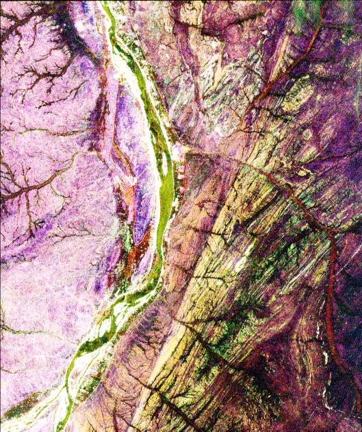
A terrane boundary close to the Nile in the Sudan, detected by radar from the Space Shuttle: the Keraf Suture. From NASA

Undoubtedly the best exposed and one of the biggest examples, the accretionary orogen of the Arabian-Nubian Shield (ANS) is a witness to the creation of a supercontinent from the remnants of an earlier one. At about 1 Ga, most of the Earth’s continental material was clumped together in the Rodinia supercontinent that existed for a quarter of a billion years. At a time of massive mantle upheaval that left most crust of that age affected by basaltic magmatism, in the form of lava flows and dyke swarms, Rodinia began to break up at 800 Ma to scatter continental fragments. Subduction zone accommodated this continental drift to form many ocean and continental-margin volcanic arcs. The ANS is a repository for many of these arcs which episodically accreted between earlier cratons to the west in Africa and those comprising Somalia and the present Indian subcontinent. Primarily the terranes are oceanic in origin and formed in the aftermath of the dismemberment of Rodinia, although a few slivers of older, reworked crust occur in Saudi Arabia and Yemen. Among the various components are ophiolites marking sutures and other major tectonic features of the orogen. The shape of the Shield is unlike that of any other major orogen of later times, for it shrinks from a width estimated at ~2000 km in Arabia to the north to vanish just south of the Equator in southern Kenya. This ‘pinched’ structure has suggested to some that the bulk of the new crust was forced laterally northwards when the African and Indian cratons collided, in the manner of toothpaste from a trodden-on tube.

Today the ANS is a harsh place, some off-limits to geologists either for political reasons or the sheer hostility and remoteness of the environment. Yet a picture has emerged, bit by bit, over the last 30 years. So a detailed review of the most extensive and varied part from 7° to 32°N and 26° to 50°E – in Egypt, Saudia Arabia, eastern Sudan, Eritrea, Yemen and northern Ethiopia is especially welcome (Johnson, P.R. et al. 2011. Late Cryogenian–Ediacaran history of the Arabian–Nubian Shield: A review of depositional, plutonic, structural, and tectonic events in the closing stages of the northern East African Orogen. Journal of African Earth Sciences, v. 61, p. 167-232). Peter Johnson himself compiled a vast amount of information during his career with the US Geological Survey Mission in Saudi Arabia and has blended the inevitably diverse ideas of his 7 co-workers – but by no means all the ideas that are in the literature. The result is a readable and well illustrated account of how the ANS assembled tectonically during times when a near-global glaciation took place, and the first macroscopic animals appear in the fossil record. Tillites and other glaciogenic rocks from the Marinoan ‘SnowBall’ occur from place to place in the ANS, as do banded iron formations that made a surprise return after a billion-year or longer absence in the Cryogenian Period . Coincidentally, glacial conditions returned to the region twice in Ordovician and Carboniferous to Permian times, forming distinctive, tectonically undisturbed sediments in the Phanerozoic cover that unconformably overlies the Neoproterozoic orogen.

Except in a few areas only recently explored, geologists have assiduously dated events in the ANS, showing nicely that all the basement rock formed after 800 Ma, and that orogenic events culminated before the start of the Cambrian period, although one or two unusual granites intruded as late as the Ordovician. The deformation is immense in places, with huge nappes, often strike-slip shear zones and exposure ranging from the lowest metamorphic grade to that in which water and granitic magma was driven from the lower Pan African crust. The range of exposed crustal levels stems partly from the tectonics, but owes a lot to the 2-3 km of modern topographic relief, unique to NE Africa and Arabia. Yet it is not uncommon to come upon delicate features such as pillowed lavas, conglomerates and finely laminated volcanoclastic tuffs. Following tectonic welding, more brittle deformation opened subsiding basins that contain exclusively sedimentary rocks derived from the newly uplifted crust, both marine and terrestrial in formation (basins of this type, in Eritrea and Ethiopia, unfortunately do not figure in the regional maps). Much of the ANS is currently the object of a gold rush, encouraged by a rising world price for the ‘inflation-proof’ comfort blanket provided by the yellow metal. Consequently, newcomers to the stampede will be well advised to mug-up on the regional picture of occurrences and gold-favourable geology provided in the review, and may be interested by other exploration possibilities for rare-earth metals and other rising stars on the London Metal Exchange, such as tin, which are often hosted in evolved granites, that stud the whole region.

Low-lying Tibet before India-Asia collision

The Tibetan plateau lies between the Himalayan...
The semi-arid Tibetan Plateau from spaceImage via Wikipedia

The vast Tibetan Plateau at an average elevation of 4500 m is a major influence on the climate of Asia, being central to the annual monsoons, as well as one the world’s largest continental tectonic features. When it formed is crucial in palaeoclimatic modelling as well as to geomorphologists and structural geologists. Whether or not it was present before the Indian subcontinent collided with Asia at 50 Ma has been the subject of perennial debate; it could have formed during the more or less continual accretion of terranes to southern Eurasia since the Jurassic Period. A novel approach to timing uplift of Tibet is obviously needed to resolve the controversies, and that may have been achieved (Hetzel, R. et al. 2011. Peneplain formation in southern Tibet predates the India-Asia collision and plateau uplift.  Geology, v.39, p.983-986). North of Lhasa is an area of coincident small plateaus at around 5200-5400 m into which are cut valleys a few hundred metres. It has the hallmarks of a peneplain stripped to the base level of erosion, and developed on Cretaceous granites. The German-Chinese-South African team applied a range of geochronological techniques to date the emplacement of the granites and their cooling history. U/Pb dating shows the granites to have crystallised between 120 to 110 Ma; U-Th/He dating of zircons in them indicate their cooling from 180° to 60°C between 90 and 70 Ma; apatite  U-Th/He and fission-track dating show that the granites experienced surface temperatures by around 55 Ma during a period of erosion at a rate of 200-400 m Ma-1. The clear inference is that an area >10 000 km2 became a peneplain by the end of the Palaeocene, to be unconformably overlain by Eocene continental redbeds.

By the Eocene the northern Lhasa Block had become a low-elevation plain from which a vast amount of sediment had been removed to be deposited elsewhere – Palaeocene and Eocene sediments are not common throughout the whole Tibetan Plateau. This is strong evidence that uplift of the Plateau only began after the India-Asia collision during the Eocene. Despite that and the erosion that would have taken place, much of the peneplain remains; given resistant bedrock peneplains can be very long-lived.

Plate tectonics monitored by diamonds

eclogite
Norwegian Eclogite. Image by kevinzim via Flickr

For more than 30 years a debate has raged about the antiquity of plate tectonics: some claim it has always operated since the Earth first acquired a rigid carapace not long after a molten state following formation of the Moon; others look to the earliest occurrences of island-arc volcanism, oceanic crust thrust onto continents as ophiolite complexes, and to high-pressure, low-temperature metamorphic rocks. The earliest evidence of this kind has been cited from as far apart in time as the oldest Archaean rocks of Greenland (3.9 Ga) and the Neoproterozoic (1 Ga to 542 Ma). A key feature produced by plate interactions that can be preserved are high-P, low-T rocks formed where old, cool oceanic lithosphere is pulled by its own increasing density into the mantle at subduction zones to form eclogites and blueschists. In the accessible crust, both rock types are unstable as well as rare and can be retrogressed to different metamorphic mineral assemblages by high-temperature events at lower pressures than those at which they formed. Relics dating back to the earliest subduction may be in the mantle, but that seems inaccessible. Yet, from time to time explosive magmatism from very deep sources brings mantle-depth materials to the surface in kimberlite pipes that are most commonly found in stabilised blocks of ancient continental crust or cratons. Again there is the problem of mineral stability when solids enter different physical conditions, but there is one mineral that preserves characteristics of its deep origins – diamond. Steven Shirer and Stephen Richardson of the Carnegie Institution of Washington and the University of Cape Town have shed light on early subduction by exploiting the relative ease of dating diamonds and their capacity for preserving other minerals captured within them (Shirey, S.B. & Richardson, S.H. 2011. Start of the Wilson cycle at 3 Ga shown by diamonds from the subcontinental mantle. Science, v. 333, p. 434-436). Their study used data from over four thousand silicate inclusions in previously dated large diamonds, made almost worthless as gemstones by their contaminants. It is these inclusions that are amenable to dating, principally by the Sm-Nd method. Adrift in the mantle high temperature would result in daughter isotopes diffusing from the minerals. Once locked within diamond that isotopic loss would be stopped by the strength of the diamond structure, so building up with time to yield an age of entrapment when sampled.  The collection spans five cratons in Australia, Africa, Asia and North America, and has an age spectrum from 1.0 to 3.5 Ga. Note that diamonds are not formed by subduction but grow as a result of reduction of carbonates or oxidation of methane in the mantle at depths between 125 to 175 km. In growing they may envelop fragments of their surroundings that formed by other processes.

A notable feature of the inclusions is that before 3.2 Ga only mantle peridotites (olivine and pyroxene) are trapped, whereas in diamonds younger than 3.0 Ga the inclusions are dominated by eclogite minerals (garnet and Na-, Al-rich omphacite pyroxenes). This dichotomy is paralleled by the rhenium and osmium isotope composition of sulfide mineral inclusions. To the authors these consistent features point to an absence of steep-angled subduction, characteristic of modern plate tectonics, from the Earth system before 3 Ga. But does that rule out plate tectonics in earlier times and cast doubt on structural and other evidence for it? Not entirely, because consumption of spreading oceanic lithosphere by the mantle can take place if basaltic rock is not converted to eclogite by high-P, low-T metamorphism when the consumed lithosphere is warmer than it generally is nowadays – this happens beneath a large stretch of the Central Andes where subduction is at a shallow angle. What Shirey and Richardson have conveyed is a sense that the dominant force of modern plate tectonics – slab-pull that is driven by increased density of eclogitised basalt – did not operate in the first 1.5 Ga of Earth history. Eclogite can also form, under the right physical conditions, when chunks of basaltic material (perhaps underplated magmatically to the base of continents) founder and fall into the mantle. The absence of eclogite inclusions seems also to rule out such delamination from the early Earth system. So whatever tectonic activity and mantle convection did take place upon and within the pre-3 Ga Earth it was probably simpler than modern geodynamics. The other matter is that the shift to dominant eclogite inclusions appears quite abrupt from the data, perhaps suggesting major upheavals around 3 Ga. The Archaean cratons do provide some evidence for a major transformation in the rate of growth of continental crust around 3 Ga; about 30-40 percent of modern continental material was generated in the following 500 Ma to reach a total of 60% of the current amount, the remaining 40% taking 2.5 Ga to form through modern plate tectonics

A plume drive for tectonics?

Himalaya Formation Source www.usgs.org US Gove...
India's tectonic travels. Image via Wikipedia

The theory of plate tectonics resolved Alfred Wegener’s search for a driving force for continental drift around half a century after his discovery faced near-universal rejection for not having one that was large enough or plausible. Plate theory recognises many forces, both driving and in opposition to tectonic movement. By far the largest is the gravitational pull exerted by subducting slabs of dense oceanic lithosphere, followed in distant second place by ridge-push, another gravity-driven force that arises from the slope on the ocean floors away from sea-floor spreading centres as the oceanic lithosphere cools and shrinks as it ages. Until very recently, no place was assigned in the theory to forces associated with the apparently non-tectonic plumes that rise through the mantle from well beneath the lithosphere from which plates are made, quite possibly because it seems logical to expect a vertically upwards force, if any, from hot plumes whereas plate tectonics is mainly concerned with horizontal movements. Looking around the present state of sea-floor spreading, the maximum pace at which plates move is just over 100 mm a-1 (100 km Ma-1) in the case of the Pacific Plate. Yet, during the Late Cretaceous and Early Palaeogene Periods after India had been wrenched away from the Gondwana supercontinent to move towards eventual collision with Eurasia the subcontinent experienced an extraordinary episode beginning around 68 Ma when its pace increased to as high as 180 km Ma-1. This accelerated motion continued over some 15 Ma and then equally abruptly slowed to less than 40 km Ma-1 around the start of the Eocene (Cande, S.C. & Stegman, D.R. 2011. Indian and African plate motions driven by the push force of the Réunion plume head. Nature, v. 475, p. 47-52; see also: Müller, R.D. 2011. Plate motion and mantle plumes. . Nature, v. 475, p. 40-41). The acceleration coincided with the start of continental flood-basalt volcanism that blanketed much of western India with the Deccan Traps across the K-P boundary when the subcontinent lay over the site of the Réunion hot spot. Coincidentally, the Réunion plume head formed at that time; i.e. the Indian continental lithosphere did not drift over an active plume, but was hit from below by one that happened to be rising to the surface. Curiously, while the Indian plate was accelerated, nearby Africa was slowed, explained by a push in the same direction of India’s travel towards a subduction zone beneath Asia and one applied to Africa that opposed its motion. Africa too resumed its usual tectonic progress at the start of the Eocene. But how did a mantle plume exert such a force: was it because it caused a local bulge from which the plates slid, or did mantle motion associated with the mushroom-like structure of the horizontally growing plume head exert viscous drag on the overlying plates? Such shifts in motion of major plates inevitably have an effect on the whole plate tectonic carapace, and the authors list a number of contemporary, distant consequences, speculating that the famous bend in the Hawaii-Emperor island and sea-mount chain in the Early Eocene resulted from the final waning of the Réunion plume head’s influence and major readjustment of tectonics.

Himalayan Horizon From Space
The result of India's final collision with Eurasia - the Himalaya. Image via Wikipedia

Coast-to-coast seismic section of Canada

Geological Map of Canada
Geological map of Canada. Image via Wikipedia

In the last few decades there have been several massive programmes aimed at imaging the lithospheric structure beneath continents, often linked with a re-assessment of the various tectonic provinces thought to be present. One of the first was a joint Indian-Soviet project managed by the National Geophysical research Institute in Hyderabad to investigate the crust of South India in the 1970s, which still graces my office wall as a memento of my own contribution to unravelling the underpinnings of this ravishing area. This was followed-up by one from the Himalaya southwards, and others have focused on Britain, the Baltic Shield and the USA by the Consortium for Continental Reflection Profiling (COCORP); the last revealing in detail large-scale, low-angle thrust faulting in the Appalachians and crustal-scale detachment faults in the eastern Basin and Range. These experiments must have been great fun, as they involved detonating large amounts of high explosive to produce sufficient energy to get returns from 100 r more km below, with all the planning needed to avoid fear and loathing among the populace, let alone frightening the horses. Nowadays, most seismic profiling onshore is done using Vibroseis, best imagined as large trucks jacked up on pads on which they bounce up and down, in manner of an LA ‘lowrider’. By comparison, marine surveys are far easier, although marine mammals have seemingly had major setbacks as a result of endless closely spaced seismic lines needed for 3-D subsurface analysis. Onshore, you only get one chance and need to pick your route with great care. Now a Canadian consortium has gone one better by using state-of-the-art seismic refraction and reflection techniques (Hammer, P.T.C. et al. 2011. The big picture: A lithospheric cross section of the North American continent. GSA Today, v. 21 (June 2011 issue), p. 4-9). Uniquely, the Canadian Lithoprobe project  coordinated a full spectrum of geological, geochemical, and geophysical research,  covering 20 years of deep-crustal research by hundreds of contributors.

A large-format profile in a supplement to the paper shows the deep relationships in the Mesozoic Cordilleran Orogen in the west, through the plexus of Precambrian Provinces of the Canadian Shield to the Palaeozoic Orogen in the east: a tract some 6000 km from west to east. The general picture is repeated stacking of orogens, with a remarkable repetition of very similar gross tectonic styles. Clearly, large-scale compressional processes have remained largely unchanged since the middle of the Archaean, and several upper parts of long-dead subduction zones and accretionary duplexes spring from the profile. The surface picture of much of the crust crossed by the stitched-together traverses gives the impression of both complex tectonics and many plutons of different ages, yet on the grand scale of the crust and lithosphere it is the tectonics that dominates: the passage of voluminous melts towards the surface has left the plethora of gently dipping deep shear zones and faults largely unmodified. Indeed, the seismic data reveal astonishingly well-preserved subducted or delaminated crust associated with collisions that occurred 2-3 billion years ago. Despite repeated accretionary tectonics spanning 3 Ga, and the Phanerozoic erosion of the Shield to reveal its innermost and deepest secrets, the crust-mantle boundary, the Moho, is astonishingly flat, ranging from 33-43 km deep. Nor is there much sign of ‘roots’ beneath orogens in the underlying lithospheric mantle; a long standing concept that appears not to be generally supportable over this stretch of the North American continent. The synthesis raises questions as to whether the Moho has always been that shallow or whether it can, in some situations, be a dynamic ‘boundary’. For that to be the case requires that the geologic crust-mantle boundary may not always correspond to the seismic discontinuity with which the Moho has previously been correlated.

PDFs of the profile can be downloaded from ftp://rock.geosociety.org/pub/GSAToday/1106insert-hammer/

Atlantic subduction due soon!

Rio de Janeiro
Rio de Janeiro, a threatened city? Image by Alcindo Correa Filho via Flickr

Earthquake prediction has not had a good record, but it seems that vastly larger tectonic processes are now becoming the subject of risk analysis (Nikolaeva, K. et al. 2011. Numerical analysis of subduction initiation risk along the Atlantic American passive margins. Geology, v. 39, p. 463-466). The Swiss, Russian and Portuguese authors focus on the old (Jurassic ~170 Ma) and presumably cold oceanic lithosphere on the western flank of the Atlantic, against both the North and South American continents. Increased density with ageing imparts a potential downwards force, but that has to overcome resistance to plate failure at passive margins. The dominance of upper continental lithosphere by rheologically weak quartz tends to make it more likely to fail than more or less quartz-free oceanic lithosphere. So, if subduction at a passive continental margin is to take place, then where and when it begins depends on the nature of the abutting continental lithosphere. That on the Atlantic’s western flank varies a lot, ranging from 75-150 km thick. Consequently the temperature at the Moho, the junction between continental lithosphere and weaker asthenosphere, varies too. The loading by marginal sedimentation also plays a role, as do continent-wide forces associated with far-distant mountain ranges, such as the Western Cordillera and Andes, and the forces from opposed sea-floor spreading from the Juan de Fuca and East Pacific systems that affect the whole of western South America, most of Central America and the far NW of North America.

Analysing all pertinent forces acting along 9 lines of section through both North and South America, the authors’ focus fell on the relatively thin continental lithosphere of the Atlantic margin of South America. It is at its thinnest along the southernmost part of the margin adjacent to Brazil, where the Moho temperature reaches as high as 735°C: the weakest link in the American continental lithosphere, where there is seismicity and also indications of igneous activity. The modelling suggests that incipient deformation may begin off southern Brazil within 4 Ma to form a zone of overthrusting, eventually evolving towards failure of the ocean-continent interface and the start of proper subduction in the succeeding 20 Ma. Other stretches of the eastern Americas are deemed safe from subduction for considerably longer by virtue of their greater thickness, lower Moho temperatures and thus higher strength. It is an interesting situation because, insofar as I understand plate tectonics, extensional or compressional failure needed to generate plate boundaries must also propagate from the weak spots that first fail; plate boundaries are lines not points. If that does not happen, then the very strength of the overwhelming longer continent-ocean interface will surely prevent subduction at a single, albeit weak link.

Paper PDF at http://xa.yimg.com/kq/groups/13231164/1842350625/name/Geology-2011-Nikolaeva-463-6.pdf

Bouncing back from the deep

eclogite
Eclogite from Norway. Image by kevinzim via Flickr

Because the average density of the rocks making up the continental crust is about 2.7 t m-3 while that of the mantle is greater than 3.0 t m-3 it might seem as though continents cannot be subducted. Indeed, that was one of the first principles of plate tectonics, which would account for continental crust dating back to 4000 Ma, whereas there is no oceanic crust older than about 150 Ma. In the southern foothills of the Alps in Piemonte, Italy is a site which refutes the hypothesis in a stunning fashion. The minor ski resort of Monte Mucrone is backed by cliffs in what to all appearances is a common-or-garden granite: it even seems to contain phenocrysts of plagioclase feldspar. Microscopic examination of the megacrysts reveals them to be made up of a complex intergrowth between jadeite, a high-pressure sodic pyroxene, and quartz. This is exactly what should form if albite, the sodium-rich kind of plagioclase feldspar, if it descended to depths over 70 km below the surface, i.e. to mantle depths.

Monte Mucrone proves that continental materials can be subducted, but also reveals that these granites popped back up again when the forces of subduction were relieved at the end of the Alpine orogeny. Other examples have since turned up, but few so spectacular as continental rocks from Switzerland (Herwartz, D. et al. 2011. Tracing two orogenic cycles in one eclogite sample by Lu-Hf garnet chronometry. Nature Geoscience, v. 4, p. 178-183). The Adula nappe of the Swiss Lepontine Alps consists of granitoid gneisses and metasediments of continental affinities, associated with mafic and ultramafic metamorphic rocks. The mafic rocks include eclogites typical of high-pressure, low-temperature metamorphism characteristic of subduction. Their minerals record formation temperatures around 680°C at a depth of more than more than 80 km. Eclogites are beautiful green and red rocks containing high-pressure omphacite pyroxene and pyrope garnet. Garnets generally contain abundant rare-earth elements especially those with the highest atomic numbers. One of these is lutetium (Lu) that has a radioactive isotope 176Lu with a half-life of 3.78×10¹⁰ years to yield a daughter isotope of hafnium 176Hf; garnets can be dated using this method. Garnets are frequently zoned, and the Adula eclogites clearly show several generations of zonation. Zoning can form as metamorphic conditions change, so in itself is not unusual, but dating different generations is. The German team from the Universities of Bonn, Cologne and Münster found that the garnets defined two distinct isochrons, one of Variscan age of just over 330 Ma, the other Alpine around 38 Ma. Clearly the pre-Variscan crust (probably once part of the African continent) had been subducted twice but had wrested itself clear of the mantle’s clutches on both occasions, each time remaining more or less intact. One idea that stems from this coincidence is that the Variscan mountain belt that formed at the earlier subduction zone subsequently split at its high P – low T core, so that the eclogites lay at a new continental margin and could suffer the same extreme compression when new subduction began there.

It also turns out that the region in which  Monte Mucrone lies, the Sesia zone of the Western Alps, also records a double whammy of continental subduction, but a repetition that occurred during the early events of the  Alpine orogeny (Rubatto, D. et al. 2011. Yo-yo subduction recorded by accessory minerals in the Italian Western Alps. Nature Geoscience, v. 4, p. 338-342). The team of Australian, Swiss and Italian geologists focused on the P-T record preserved in zoned garnets, allanites and zircons and evidence for two generation of white micas in eclogites and blueschists. Backed by U-Pb dating of zircon and allanite zones, the authots uncovered two episodes of deep subduction separated by period of rapid exhumation over the period between 79 to 65 Ma ago. The double subduction took place while the African plate converged obliquely with Eurasia; a strike-slip configuration that probably resulted in large-scale switches from compression to extension.

See also: Bruekner, H.K. 2011. Double-dunk tectonics. Nature Geoscience, v. 4, p. 136-138

Hard-core continental lithosphere

The oldest and most stable parts of the continents are known as cratons, after the Greek word for strength κράτο (kratos). All the present continents have at least one craton (Africa and South America have 4 each, and Eurasia 6 or 7). Each has remained unaffected by major deformation for a billion years or more, even during continent-to-continent collisions in which they participated. Almost all cratons began to form during the Archaean Eon before 2500 Ma, but most became rigid long after. Several theories have been suggested to account for their durability, one commonly accepted being that somehow the crust ‘ripened’ so that most of the heat-producing radioactive isotopes of U, Th and K were moved by igneous and metamorphic processes to the uppermost crust, along with water; most cratons expose fragments of anhydrous granulites of tonalitic composition. These bear evidence of having formed at the base of the continental crust and have been heavily depleted in “granitophile” trace elements. As a result they cannot undergo partial melting under normal geothermal conditions and where they remain at great depth are much cooler than younger, deep crust. The other dominant feature of cratonic lithosphere is a mantle portion that is anomalously thick (sometimes down to 250 km); in some cases there is little if any sign of asthenosphere beneath such ‘keels’. Research on rocks brought up from the ‘roots’ of cratons by the kimberlite magmas famous for their diamonds points to that deep mantle itself having conferred great rigidity and thus longevity (Peslier, A.H. et al. 2010. Olivine water contents in the continental lithosphere and the longevity of cratons. Nature, v. 467, p. 78-81).

The presence of water in minerals that make up igneous and metamorphic rocks enables them to begin melting at lower temperatures than their dry equivalents, and also to behave in a more plastic fashion under stress. Anne Peslier of NASA in Houston and her US and German colleagues analysed the minerals in ultramafic mantle rocks dragged upwards by kimberlites that punched through the Kaapvaal craton in southern Africa long after it formed. The dominant mantle mineral is olivine (50-80%), generally thought of as anhydrous but typically containing a few hundred parts per million by weight. Olivines in the Kaapvaal mantle xenoliths become drier with increasing depth of their formation (determined from their mineralogy in which garnet is stable at the deepest levels). At depths around 150-250 km low water content in olivine makes it and the mantle itself 20 to 3000 times stronger than the asthenosphere, which protects it from the underlying flow associated with tectonic motions.

How such root zone of continents may have formed has been addressed by two papers on seismic structure beneath the best studied craton; that of the Canadian Shield (Yuan, H. & Romanowicz, B. 2010. Lithospheric layering in the North American craton. Nature, v. 466, p. 1063-1068; Miller, M.S. & Eaton, D.W. 2010. Formation of cratonic mantle keels by arc accretion: Evidence from S receiver functions. Geophysical Research Letters, v. 37, doi:10.1029/2010GL044366). In the first, Yuan and Romanowicz of the Berkeley Seismological Laboratory, California use a form of seismic tomography to map anisotropy in the mantle along transects that cross the ancient core of the North American continent. Their results chart the depth of the base of the lithosphere and also define two layers in the lithospheric mantle. The upper layer (down to 150 km) only occurs beneath the Archaean craton, and the top of the asthenosphere ranges from 100-240 km down: at its deepest beneath the craton. The sub-craton mantle they ascribe to chemical depletion of its upper part during early lithospheric evolution, and later addition of the less chemically evolved deeper layer. Miller and Eaton of the Universities of California USA and Calgary Canada used S-wave data from eight seismic stations extending from WSW to ENE over the western cordillera and the Canadian Shield to the Arctic islands of Canada. Their results show a similar variation in dept of the base of the lithosphere and resolve several roughly eastward-dipping boundaries in the sub-craton lithospheric mantle, which they link to Precambrian volcanic arcs preserved in the upper crust above them; i.e. suggesting that the upper layer in the first paper stems from a major episode of arc accretion that built the Canadian Shield.

Hard-core continental lithosphere

The oldest and most stable parts of the continents are known as cratons, after the Greek word for strength κράτο (kratos). All the present continents have at least one craton (Africa and South America have 4 each, and Eurasia 6 or 7). Each has remained unaffected by major deformation for a billion years or more, even during continent-to-continent collisions in which they participated. Almost all cratons began to form during the Archaean Eon before 2500 Ma, but most became rigid long after. Several theories have been suggested to account for their durability, one commonly accepted being that somehow the crust ‘ripened’ so that most of the heat-producing radioactive isotopes of U, Th and K were moved by igneous and metamorphic processes to the uppermost crust, along with water; most cratons expose fragments of anhydrous granulites of tonalitic composition. These bear evidence of having formed at the base of the continental crust and have been heavily depleted in “granitophile” trace elements. As a result they cannot undergo partial melting under normal geothermal conditions and where they remain at great depth are much cooler than younger, deep crust. The other dominant feature of cratonic lithosphere is a mantle portion that is anomalously thick (sometimes down to 250 km); in some cases there is little if any sign of asthenosphere beneath such ‘keels’. Research on rocks brought up from the ‘roots’ of cratons by the kimberlite magmas famous for their diamonds points to that deep mantle itself having conferred great rigidity and thus longevity (Peslier, A.H. et al. 2010. Olivine water contents in the continental lithosphere and the longevity of cratons. Nature, v. 467, p. 78-81).

The presence of water in minerals that make up igneous and metamorphic rocks enables them to begin melting at lower temperatures than their dry equivalents, and also to behave in a more plastic fashion under stress. Anne Peslier of NASA in Houston and her US and German colleagues analysed the minerals in ultramafic mantle rocks dragged upwards by kimberlites that punched through the Kaapvaal craton in southern Africa long after it formed. The dominant mantle mineral is olivine (50-80%), generally thought of as anhydrous but typically containing a few hundred parts per million by weight. Olivines in the Kaapvaal mantle xenoliths become drier with increasing depth of their formation (determined from their mineralogy in which garnet is stable at the deepest levels). At depths around 150-250 km low water content in olivine makes it and the mantle itself 20 to 3000 times stronger than the asthenosphere, which protects it from the underlying flow associated with tectonic motions.

How such root zone of continents may have formed has been addressed by two papers on seismic structure beneath the best studied craton; that of the Canadian Shield (Yuan, H. & Romanowicz, B. 2010. Lithospheric layering in the North American craton. Nature, v. 466, p. 1063-1068; Miller, M.S. & Eaton, D.W. 2010. Formation of cratonic mantle keels by arc accretion: Evidence from S receiver functions. Geophysical Research Letters, v. 37, doi:10.1029/2010GL044366).In the first, Yuan and Romanowicz of the Berkeley Seismological Laboratory, California use a form of seismic tomography to map anisotropy in the mantle along transects that cross the ancient core of the North American continent. Their results chart the depth of the base of the lithosphere and also define two layers in the lithospheric mantle. The upper layer (down to 150 km) only occurs beneath the Archaean craton, and the top of the asthenosphere ranges from 100-240 km down: at its deepest beneath the craton. The sub-craton mantle they ascribe to chemical depletion of its upper part during early lithospheric evolution, and later addition of the less chemically evolved deeper layer. Miller and Eaton of the Universities of California USA and Calgary Canada used S-wave data from eight seismic stations extending from WSW to ENE over the western cordillera and the Canadian Shield to the Arctic islands of Canada. Their results show a similar variation in dept of the base of the lithosphere and resolve several roughly eastward-dipping boundaries in the sub-craton lithospheric mantle, which they link to Precambrian volcanic arcs preserved in the upper crust above them; i.e. suggesting that the upper layer in the first paper stems from a major episode of arc accretion that built the Canadian Shield.

Low-angle extensional detachments at ocean ridges

The discovery in the 1970s that some low-angled faults have an extensional or normal sense of displacement stemmed from extensional systems in the continental crust, exemplified by the Basin and Range Province of western North America. Yet the largest extensional systems on Earth are those associated with mid-ocean ridges, and in the 1980s some of those were shown to involve low-angled detachments too. Michael Cheadle and Craig Grimes (University of Wyoming and Mississippi State University, USA) review the latest word on oceanic extensional complexes revealed at the AGO Chapman Conference in May 2010 (Cheadle, M. & Grimes, C. 2010. To fault or not to fault. Nature Geoscience, v. 3, p.454-456). As in continental extension, this kind of deformation at divergent margins may produce core complexes uplifted as a result of tectonic unroofing by low-angled detachments, thereby revealing oceanic mantle lithosphere on the ocean floor. Such peculiarities seem to be absent from fast spreading ridges such as the East Pacific Rise and occur where spreading is slow. They are best developed where spreading is starved of magma injection to produce the classic sheeted-dyke complexes of the middle oceanic crust, and with unusually thick oceanic lithosphere. Yet the ocean floor must spread at these localities, and that is achieved by extensional tectonics that accommodates up to 125 km of spreading with next to no magmatism: 4 Ma-worth of spreading.

For extensional faults to develop into low-angled detachments rocks must be weak, otherwise simple steep, domino-style faults would form. Penetration of seawater down faults weakens oceanic lithosphere through hydration reactions that produce clays and serpentines, which encourage the formation of ductile shear zones. Interestingly, some of the largest hydrothermal systems on the mid-Atlantic Ridge coincide with core complexes, and exude hydrogen – a product of serpentinisation – as well as methane and metal-rich brines.

Plate theory moves on

The last 40 to 50 years have seen the theory of plate tectonics supported by more and more empirical evidence from sea-floor magnetism, seismicity, bathymetry and a growing number of other features that relate to Earth’s dynamism. Yet the original concepts of rigid plates and their dislocation from one another and the underlying mantle have been undermined to a degree by the wealth of data now available. Increasing resolution of seismic tomography is revealing what is happening in the depths of the mantle on which growing confidence can be placed. Matching these increasingly revealing sources of data has been the computing power to try to blend them all with rheological theory and thereby model the way the world works. The latest of these modelling ventures does seem to move plate theory onto a significantly higher plane (Stadler, G. et al. 2010. The dynamics of plate tectonics and mantle flow: from local to global scales. Science, v. 329, p. 1033-1038). The keys to this step are: increasingly sophisticated software that encompasses the contributory factors, akin to models used by mechanical and hydraulic engineers; faster computing that allows a decrease in the size of the 3-D cells used in assessing all the interactions as realistically as possible, and a great deal of graphic creativity so that we can visualise the results. At its centre is varying rock strength, the principal ‘engineering’ input derived from seismic tomography, blended with the gravitational and thermal forces that drive Earth’s ‘engine’.

Stadler et al.’s development divides up the planet into a 3-D mesh whose resolution varies according to the likely complexity of motions within and upon the Earth. For instance there is not much call for detail for what lies below abyssal plains of the ocean floor, so available computing power can be focused on the more intricate parts of the tectonic set-up, especially subduction zones that are both the most spectacular features of the Earth’s behaviour and the source of the main force that drives its surface parts – slab pull. Already the approach is producing more questions than answers. For instance, building in the data that show something of convection in the deep mantle makes the model’s output for the more shallow-seated and better known processes deviate more than expected from what is observed – less comprehensive and more coarse approaches previously seemed to be match deep and shallow processes quite well. This is a difficult topic to express merely in words, but fortunately the paper has been made freely available at http://users.ices.utexas.edu/~carsten/papers/StadlerGurnisBursteddeEtAl10.pdf

See also: Becker, T. 2010. Fine-scale modelling of global plate tectonics. Science, v. 329, p. 1020-1021.

Plate theory moves on

more empirical evidence from sea-floor magnetism, seismicity, bathymetry and a growing number of other features that relate to Earth’s dynamism. Yet the original concepts of rigid plates and their dislocation from one another and the underlying mantle have been undermined to a degree by the wealth of data now available. Increasing resolution of seismic tomography is revealing what is happening in the depths of the mantle on which growing confidence can be placed. Matching these increasingly revealing sources of data has been the computing power to try to blend them all with rheological theory and thereby model the way the world works. The latest of these modelling ventures does seem to move plate theory onto a significantly higher plane (Stadler, G. et al. 2010. The dynamics of plate tectonics and mantle flow: from local to global scales. Science, v. 329, p. 1033-1038). The keys to this step are: increasingly sophisticated software that encompasses the contributory factors, akin to models used by mechanical and hydraulic engineers; faster computing that allows a decrease in the size of the 3-D cells used in assessing all the interactions as realistically as possible, and a great deal of graphic creativity so that we can visualise the results. At its centre is varying rock strength, the principal ‘engineering’ input derived from seismic tomography, blended with the gravitational and thermal forces that drive Earth’s ‘engine’

Stadler et al.’s development divides up the planet into a 3-D mesh whose resolution varies according to the likely complexity of motions within and upon the Earth. For instance there is not much call for detail for what lies below abyssal plains of the ocean floor, so available computing power can be focused on the more intricate parts of the tectonic set-up, especially subduction zones that are both the most spectacular features of the Earth’s behaviour and the source of the main force that drives its surface parts – slab pull. Already the approach is producing more questions than answers. For instance, building in the data that show something of convection in the deep mantle makes the model’s output for the more shallow-seated and better known processes deviate more than expected from what is observed – less comprehensive and more coarse approaches previously seemed to be match deep and shallow processes quite well. This is a difficult topic to express merely in words, but fortunately the paper has been made freely available at http://users.ices.utexas.edu/~carsten/papers/StadlerGurnisBursteddeEtAl10.pdf

See also: Becker, T. 2010. Fine-scale modelling of global plate tectonics. Science, v. 329, p. 1020-1021.

Low-angle extensional detachments at ocean ridges

The discovery in the 1970s that some low-angled faults have an extensional or normal sense of displacement stemmed from extensional systems in the continental crust, exemplified by the Basin and Range Province of western North America. Yet the largest extensional systems on Earth are those associated with mid-ocean ridges, and in the 1980s some of those were shown to involve low-angled detachments too. Michael Cheadle and Craig Grimes (University of Wyoming and Mississippi State University, USA) review the latest word on oceanic extensional complexes revealed at the AGO Chapman Conference in May 2010 (Cheadle, M. & Grimes, C. 2010. To fault or not to fault. Nature Geoscience, v. 3, p.454-456). As in continental extension, this kind of deformation at divergent margins may produce core complexes uplifted as a result of tectonic unroofing by low-angled detachments, thereby revealing oceanic mantle lithosphere on the ocean floor. Such peculiarities seem to be absent from fast spreading ridges such as the East Pacific Rise and occur where spreading is slow. They are best developed where spreading is starved of magma injection to produce the classic sheeted-dyke complexes of the middle oceanic crust, and with unusually thick oceanic lithosphere. Yet the ocean floor must spread at these localities, and that is achieved by extensional tectonics that accommodates up to 125 km of spreading with next to no magmatism: 4 Ma-worth of spreading.

For extensional faults to develop into low-angled detachments rocks must be weak, otherwise simple steep, domino-style faults would form. Penetration of seawater down faults weakens oceanic lithosphere through hydration reactions that produce clays and serpentines, which encourage the formation of ductile shear zones. Interestingly, some of the largest hydrothermal systems on the mid-Atlantic Ridge coincide with core complexes, and exude hydrogen – a product of serpentinisation – as well as methane and metal-rich brines

Ocean-floor topography-age correlation challenged

One of the elements comprising the canon of plate tectonics is that as plates spread away from constructive margins the depth to the ocean floor increases in direct proportion to the square root of the underling lithosphere’s age. This is generally considered to reflect steady passive cooling and increasing density of initially hot lithosphere produced at ridge systems. The resulting slope of the ocean floor is said to result in one of the gravitational forces that sustain plate tectonics – ‘ridge slide’. The Pacific Ocean floor is a good test for the hypothesis, but unfortunately does not show a linear depth vs Öage relationship (Adam, C. & Vidal, V. 2010. Mantle flow drives the subsidence of oceanic plates. Science, v. 328, p. 83-85). Instead, the ocean floor flattens out beyond a threshold distance, which has been a source of puzzlement for decades. However, a plot of depth against the square root of distance from the ridge along estimated lines of mantle convective flow is consistently linear. The depth curve seems therefore to reflect past changes in the direction of sea-floor spreading and changes in the deeper mantle convection, thereby linking reality to the original model for continental drift that had mantle convection at its heart. That view was discarded by geophysicists on account of a widespread belief that the asthenosphere was too weak to transmit forces from below to the rigid lithospheric plates.

Joining the Neoproterozoic dots

Riven by the effects of at least two Wilson cycles of rifting drifting and collision, and then covered by a variety of later sediments, late-Precambrian rocks at high latitudes around today’s North Atlantic are nowhere near as coherent as their counterparts in, for instance, Africa. Also they have a long history of field investigation that began long before the unifying theory of plate tectonics, using a parochial rather than a ‘joined-up’ approach. Consequently there is a vast literature, as witness that of say the Moines or the Dalradian in Scotland, which has strangely acted as a hindrance rather than a boon to synthesisers: not that attempts haven’t been made in recent decades. Interestingly, a multi-hemisphere approach to unification, combining Australian and British geologists, seems to have made a great deal of ground (Cawood, P.A. et al. 2010. Neoproterozoic orogeny along the margin of Rodinia: Valhalla orogen, North Atlantic. Geology, v. 38, p. 99-102).

The Rodinia (‘Motherland’) supercontinent united all continental lithosphere at the end of the Mesoproterozoic era, existed between 1100 and 750 Ma, then broke into eight drifting continents during the Neoproterozoic. Like the later Pangaea (‘all of mother Earth’) formed when all these wandering masses finally clanged together again, conditions deep in the interior of Rodinia were probably tectonically and geomorphologically almost static. All the action would have been around its rim, towards which much of global sea-floor spreading ultimately was directed. Far older continental material now juxtaposed across the high-latitude North Atlantic was in just such an exposed position at the edge of the supercontinent; Greenland abutting the present Baltic crystalline mass. Local sea-floor spreading twisted Baltica from this part of Rodinia in a clockwise manner, to leave a large triangular sea in its wake. This Asgard Sea (why not Toblerone?) received debris from uplifted masses of older crust, to fill a deep sedimentary basin ready for deformation should tectonics warrant that. Two such episodes (980-910, 830-710 Ma) created the older Neoproterozoic metamorphic belts which have long drawn geologists to study Greenland, Scotland and Scandinavia in great detail: for British geologists the attraction was the complexity of the Moine Schists in which John Ramsay famously laid the foundations of modern polyphase structural analysis in the late 1950s and 1960s. A noteworthy point is that by comparison with most mountain belts, the Valhalla orogen took an awfully long time to form: around 300 Ma.

An old theory resurrected

Before the wide acceptance of sea-floor spreading and continental drift geoscientists had to seek explanations for the common occurrence of very similar fossils on now widely separated land masses. On the other hand, Alfred Wegener used observations such as the presence of fossilised tongue-like Glossopteris leaves in the Permian sediments of all the southern continents, and similar distributions of reptiles to support his theory. His detractors tried to explain away the fossil evidence by suggesting now-vanished land bridges, ‘island hopping’, floating seeds, and natural Noah’s Arks carrying animals and so on. With the discovery of irrefutable evidence for sea-floor spreading Wegener was vindicated, albeit long after his death, and the views of his detractors became ridiculed and neglected in their turn. But one puzzle remained: the fauna of Madagascar. Beginning about 170 Ma ago, Madagascar along with India parted company with Africa, to the extent that Madagascar is now more than 430 km off the East African coast (India moved much further independently).

Madagascar, of course, is famous for its lemurs but its fauna includes other animals found nowhere else. Another oddity is that late-Mesozoic Malagasy sediments have yielded no evidence for ancestors to these animals, so the fauna could not have evolved from African stock set adrift with the microcontinent. The only explanation then seems to be that the little animal ancestors drifted on vegetation rafts from Africa – note this would be more unlikely for large animals. Yet today’s current patterns make any drift toward Madagascar highly unlikely. The puzzle may have been resolved, if one believes computer modelling, by the different surface flow patterns of the Indian Ocean during the Palaeocene (Ali, J.R. & Huber, M. 2010. Mammalian biodiversity on Madagascar controlled by ocean currents. Nature, v. 463, p. 653-656). At that time the drifting island was further south than it is now, and currents would intermittently have flowed from East Africa towards it. As it was driven northwards, so it entered the influence of the westward flowing, South Equatorial Current that now isolates it from its parent continent. The idea of rafting, first developed in 1940 by George Gaylord Simpson, an opponent of anything smacking of continental drift, also seems the only possibility if the arrival of New World monkeys in South America and other oddities are to be explained.

See also: Krause, D.W. 2010. Washed up in Madagascar. Nature, v. 463, p. 613-614.

Dating subduction

The most distinctive products of the high-pressure, low-temperature metamorphism along subduction zones are stunningly coloured blueschists formed from ocean-floor basalts, their colour deriving from the sodium-rich amphibole glaucophane. Yet the defining mineral for subduction-zone metamorphism is lawsonite, which takes up the calcium from plagioclase feldspar that becomes unstable. Having formed at depths of up to 100 km, blueschists found at the surface had to rise slowly from mantle depths after metamorphism. Consequently, it is nearly impossible to unravel the date of their formation from those of later events. Being basaltic, blueschists also lack the usual elements whose unstable isotopes are commonly used for radiometric dating: potassium, rubidium, uranium and thorium. However, they do contain rare-earth elements, an isotope of one (176Lu) being unstable. Applying the Lu-Hf dating method to lawsonite ties down precisely when basalts achieved the narrow P-T range at which lawsonite forms (Mulcahy, S.R. et al. 2009. Lawsonite Lu-Hf geochronology: A new geochronometer for subduction zone processes. Geology, v. 37, p. 987-990). Sean Mulcahy of the Unigversity of Nevada and colleagues from Washington State chose a sample from the type locality for lawsonite discovered in the late 19th century by Andrew Lawson: the Franciscan blueschists of the Tiburon Peninsula in California. The Franciscan Complex formed during subduction at 145.5 Ma.

Phew, there is a mantle plume under Hawaii after all

Along with constructive and destructive plate boundaries volcanic hotspots within plates and sometimes at plate boundaries epitomise modern Earth science. Assuming that they are fixed points of reference allows the absolute motions of tectonic plates to be worked out, although it seems that some do move around. The evidence for hotspots being fixed or at least moving much more slowly than do plates are the chains of extinct volcanic islands or seamounts that extend away from active volcanic centres in the direction of plate motion. The most debated aspect of hotspots is whether they stem from processes in the upper mantle just beneath the asthenosphere or are the heads of cylindrical plumes of hot mantle that rise from the region next to the outer core. Seismic tomography has been claimed capable of resolving between the two possibilities, but its spatial resolution depends very much on the spacing of seismometers that provide the data that tomography subjects to highly complex processing. Some have claimed that the resolution of early tomography lends itself to producing artefacts that look like sought-after mantle structures (see Geoscience consensus challenged in EPN of December 2003).

One hotspot that has all the characteristics of a plume head, but which seismic tomography has been unable to detect is the volcanically active Big Island of the Hawaiian chain. The response to that somewhat embarrassing failure has been to deploy 30-odd seismometers on the seabed immediately around Hawaii and then to shift them to a wider spacing further from the island between 2005 to 2007. Together with 10 stations on the islands themselves, the array recorded 2146 S-wave arrivals from 97 earthquakes (Wolfe, C.J. et al. 2009. Mantle shear-wave velocity structure beneath the Hawaiian hot spot. Science, v. 326, p. 1388-1390). The results are reassuring, for the show in detail that indeed there is a vertical zone of low S-wave speeds indicating hotter, less rigid mantle that extends down to at least 1200 km. It is several hundred kilometres across, and is indeed a plume surrounded by a ‘tube’ of colder more rigid mantle.

See also: Kerr, R.A. 2009. Sea-floor study gives plumes from the deep mantle a boost. Science, v. 326, p. 1330.

Hot tectonics in the Archaean

The first thing that strikes you when looking at a small-scale geological maps of many deformed Archaean terrains – most of them are deformed – is how different they seem compared with those of later aeons. Bulbous granitic plutons separate slim and irregular, sometimes cusp-adorned areas of volcanic and sedimentary rocks. This is classic granite-greenstone terrain. Many geologists who have worked on Archaean rocks find it hard to pin down signs of ‘modern’ plate tectonics and the typical orogens of continent-continent collision zones, yet non-uniformitarian ideas on Archaean tectonics have become passé in the last 25-30 years. That seems odd, considering that the Earth’s internal heat production by radioactive decay must have been higher as less radioactive U, Th and K isotopes would have decayed in the very distant past. Convective mantle flow would have been faster, lithosphere would not have been so thick as now, and plates would have moved more rapidly in order that radioactive heat and that left over from early accretion and the Moon-forming event could escape. Whichever way one looks at such a scenario – plates as big as modern ones or more small plates – there is no escaping that younger, warmer lithosphere would have re-entered the mantle. Geochemistry of Archaean granitic rocks is so different from those of later aeons that their formative processes must have differed too. Quite probably descending basaltic crust would not have dehydrated to produce eclogite under low-T, high-P conditions, and that would prevent steep subduction, so that slab-pull may not have been the driving force for Archaean tectonics.

Two recent papers refresh the idea that the present is not entirely a key to the Earth’s Archaean past. One suggests an entirely alien kind of orogenic activity: that of very hot deformation of weak lithosphere (Chardon, D. et al. 2009. Flow of ultra-hot orogens: A view from the Precambrian, clues for the Phanerozoic. Tectonophysics, v. 477, p. 105-108). Dominique Chardon of the Université de Toulouse and colleagues from the Université de Rennes, highlight the dominance in orogens of the Archaean and early Proterozoic of ductile deformation imposed on massive accretion of magma produced by mantle processes, compared with the dominantly brittle style that dominates modern, cold orogens. Accumulated radiometric dating of the main building material of the continents – diorites and grandiorites – indicates that the 1.5 Ga of the Archaean witnessed the formation of not only the earliest continental crust but most (65%) of the rest of it. A summary of an emerging explanation for explosive continent production appeared in the first 2010 issue of Scientific American (Simpson, S. 2009. Violent origins of continents. Scientific American v. 302(1), p. 46-53). This rests on rapidly growing evidence, much unearthed by Andrew Glikson of the Australian National University, for the influence of major impacts that flung debris far and wide and perturbed the mantle’s thermal structure on a massive scale (Glikson, A. 2008. Field evidence for Eros-scale asteroids and impact forcing of Precambrian geodynamic episodes, Kaapvaal (south Africa) and Pilbara (Western Australia) cratons. Earth and Planetary Science Letters, v. 267, p. 558-570). Beds of impact-related spherules are turning up throughout Archaean greenstone-belt sequences. There are also megabreccias that could be debris lifted by tsunamis vcaused by impacts in the Archaean oceans. Glikson has demonstrated that the timing of such evidence closely matches that of magmatic outbursts that created continental crust. He has proposed that the thermal effects of the large impacts set in motion or deflected a large number of convective mantle plumes that drove the necessary magmatism.

Evidence for Hadean continental crust takes a knock

The pre-4 Ga ages recorded by some of the detrital zircons from the 3 Ga Jack Hills sandstones have been used to suggest that continental crust formed from about 4.4 Ga onwards, which implies some kind of recycling process in the tectonics of the early earth to generate and fractionate the necessary silicic magmas. That assumes zircons only form in silicic magmas produced by fractionation in volcanic arcs. The plagiogranites found in small amounts in ophiolites also contain zircons, thereby countering the claim for Hadean continents. More revealing are zircons found in granite magmas that represent the last dregs of melts formed by giant impact (Darling, J. et al. 2009. Impact melt sheet zircons and their implications for the Hadean. Geology, v. 37, p. 927-930). The huge impact-induced mafic to ultramafic melt sheet at Sudbury, Ontario, formed around 1.85 Ga. Zircons extracted from late-stage granites in the body are similar to those with Hadean ages.

The Great Bend of the Pacific ocean floor

Ocean island chains are trackways of moving lithospheric plates relative to the underlying mantle. Mantle hotspots act in a similar manner to a candle that would burn a line in a sheet of paper were one to be passed over it. The largest, most coherent and best studied ocean island chain is that of the Hawaiian Islands and the Emperor Seamounts  in the NW Pacific. The volcanoes that built the chain range in age continuously from Late Cretaceous (81 Ma) at the northern tip of the Emperor Seamounts where they touch the Kamchatka Peninsula to the present in the Big Island of Hawai’i itself. So far, so good for the hotspot-track hypothesis. But the chain is bent into a WNW segment (Hawaii) and one that trends NNW (Emperor). That might seem to be superb evidence that the direction of West Pacific sea-floor spreading underwent a sudden, 60º change around 47 Ma (the age of the Diakakuji seamount at the apex of the bend). However, measurements in 2001 of palaeomagnetic latitude in sea-floor cores along the chain revealed clear palaeomagnetic evidence that the Hawaiian hot spot has not always been fixed relative to moving lithospheric plates.  From Late Cretaceous to Late Eocene times the hotspot seems to have been was shifting southwards relative to the north magnetic pole at a rate comparable with that of sea-floor spreading, and then became stationary to explain the 60° bend in the chain (See American Geophysical Union 2001 Fall Meeting in EPN for January 2002).

Further work has been done since 2001, and a review of the huge oddity that bucks John Tuzo Wilson’s 1963 theory of hotspots fixed in space and time is timely (Tarduno, J. et al. 2009. The bent Hawaiian-Emperor hotspot track: inheriting the mantle wind. Science, v. 324, p. 50-53). Data have moved on to suggest that the hotspot is indeed the head of narrow mantle plume originating deep down, perhaps even near the core – mantle boundary (CMB). But could such a massive structure change it’s behaviour so that its head would move? Some have suggested the development of a propagating crack in the Pacific lithosphere and then its closure, but no evidence points unerringly that way. After considering a range of possible mechanisms, the authors suggest that the great bend records past changes in mantle flow beneath the West Pacific, so that the plume would itself have bent in the vertical dimension. Seismic tomography has revealed apparently low-angled zones of hot, low-velocity mantle, such as one that may (or may not) connect with the Afar plume beneath the triple junction of the East African Rift, the Red Sea and the Gulf of Aden after rising from the CMB south of Cape Town. They are tantalising results, because the resolution is simply not good enough to be sure. It needs an order of magnitude better tomographic resolution of mantle features to truly make more headway.

Rheic Ocean reviewed

Since the late 1960s when John Dewey and a few other geologists began to apply plate-tectonic ideas to palaeogeography, most of us when asked to name an ancient ocean would have blurted out ‘Iapetus’. Yet, another Palaeozoic ocean, the Rheic Ocean, left a far more profound mark on the Palaeozoic world: its closure around the end of the Palaeozoic Era united all the continents in Wegener’s Pangaea supercontinent, and threw up a vast mountain belt at the suture. The earlier evolution of the Rheic Ocean  involved the spalling of a series of microcontinental slivers from the flank of the earlier Gondwana supercontinent. Damien Nance and Ulf Linneman review the fascinating story of the Rheic Ocean in a nicely succinct way (R.D. Nance & Linnemann, U. 2008. The Rheic Ocean: Origin, evolution and significance. GSA Today, v. 18 (December 2008m issue), p. 4-12).


Archaean ‘Waterworld’

Readers might remember with some pain the 1995 film Waterworld, starring Kevin Costner: an actor so wooden he could not sink. That was based on the unlikely scenario that if all the ice caps melted the continents would be drowned entirely. In fact that global melting would raise sea level by a mere 67 m. A far higher sea-level rise took place during the Cretaceous, arguably because fast sea-floor spreading and subduction created a larger volume of ‘warm’ and so less-dense ocean lithosphere than there is now. The volume of the ocean basins shrank as a result, displacing ocean water onto low-lying areas of the continents. Something more dramatic has been suggested for the Archaean Earth (Flament, N. et al. 2008. A case for late-Archaean continental emergence from thermal evolution models and hypsometry. Earth and Planetary Science Letters, v. 275, p. 326-336). The starting point for the discussion by Flament and his Australian and French colleagues from the universities of Sydney and Lyon is that the reason for the present hypsometric distribution of surface elevations between ocean floor and continents is cooling of the Earth that has changed the isostatic balance between oceanic and continental lithosphere. That progressively sharpens the topographic contrast thereby increasing continental freeboard. Archaean times involved a hotter mantle due mainly to greater radiogenic heat production. Flament ­et al. argue that would have lessened the rigidity of continental lithosphere, so reducing the ability of the crust to thicken, whereas ocean floor would have had a higher relative elevation, so reducing ocean basin volume. As in the Cretaceous oceans would have flooded continents, but to a far greater extent, so that as little as 3% of the Earth surface was land.

Are sheeted dykes significant?

More than abyssal sediments, pillow basalt, differentiated gabbro and depleted peridotite sheeted dyke complexes have long been a primary identifier for oceanic lithosphere preserved in ophiolites. That assumption has recently been questioned (Robinson, P.T. et al. 2008. The significance of sheeted dyke complexes in ophiolites. GSA Today, v. 18 (November 2008), p. 4-10). Ian Gass first discovered units made up solely of dykes that intrude one another with no intervening screens of other host rocks in the Troodos ophiolite of Cyprus in 1968. Sheeted dyke complexes became widely regarded as characteristic of extensional, sea-floor spreading environments connected to basaltic magma chambers, each increment of extension being filled with magma. They have also been imaged in eroded walls of ocean fracture systems and cut through by ocean drill cores, supporting this notion. In fact, many ophiolites are devoid of sheeted complexes, despite having all the other components of mafic-ultramafic lithosphere. Robinson et al. argue that sheeted dykes only form where spreading rates and magma supply are balanced, as expected at true constructive plate margins but far less likely at other extensional zones associated with plate tectonics, such as those in back-arc basins above subduction zones. Even at true spreading centres that generate new ocean floor magma supply may not balance extension, for instance where spreading rates are slow. Moreover, a great many ophiolites show geochemical affinities that are more akin to supra-subduction magmatic processes than those that produce mid-ocean ridge basalt.

Plate tectonics in time and space

Seismic tomography becomes increasingly revealing as the capacity of supercomputers grows. On top of that, more sophisticated software allows present-day mantle cross sections to be reverse modelled with surface plate motions to reconstruct an idea of mantle dynamics back to Mesozoic times. Geophysicists at the California Institute of Technology give a taste of the possibilities from the subduction history of North America (Liu, L. et al. 2008. Reconstructing Farallon plate subduction beneath North America back to the Late Cretaceous. Science, v. 322, p. 934-938). Investigating 3-D evolution is the key to connecting rigid plate tectonics and fluid convection that has long been postulated but remains obscure. However, while reasonable reconstructions of global plate motions are possible using sea-floor magnetic stripes that go back to the Cretaceous, seismic tomography only images the mantle’s present structure. So it might seem that generating a 3-D ‘geomovie’ is more of an expensive illusion than a model of past realities.

The logic behind the modelling is that today’s mantle temperature structure – that is what tomograms show – stems from past plate activity. For instance, a deep cold, slab-like anomaly dipping eastward beneath eastern North America can reasonably be inferred to be a relic of the Farallon Plate, which formerly constituted floor of the eastern Pacific. That plate was subducted beneath the west edge of the continent until around 40 Ma, when the East Pacific Rise that had driven it was subducted. The present thermal structure shown by the tomogram has, in a sense, ‘faded’ as a result of thermal relaxation of the original anomalies by heat diffusion. Choosing geologically reasonable starting conditions for long-term evolution of a mantle segment enables iterative forward modelling to try and achieve the present set-up. While there is an element of circularity in this logic, such a dynamic model has a predictive aspect; i.e. as cold, dense material in the mantle sinks it tends to pull the surface downwards, allowing marine flooding of continental interiors. During the Late Cretaceous this did happen spectacularly in North America, and Liu et al’s model shows this. Yet sea level also rose globally at the time, thereby amplifying the inundation. Although geeomodellers will be excited by Liu et al’s developments, it is modelling and even the simplest of models is acutely sensitive to the chosen starting conditions, as meteorologists with vastly more real data at hand have discovered again and again.

See also: Steinburger, B. 2008. Reconstructing Earth history in three dimensions. Science, v. 322, p. 866-868

The ocean that tried to swallow itself

Wegener’s famous supercontinent Pangaea lasted for about 200 Ma from the mid Carboniferous to the late Triassic, and formed a ‘slice world’ extending almost from pole to pole. Yet it had a vast spreading embayment on its eastern side around which wrapped two ‘horns’ of continental lithosphere: an ocean dubbed ‘Palaeotethys’. Another peculiarity is that at its core Pangaea is marked by a huge, orogenic belt that seems to have been buckled on a continental scale: the Iberian-Amorican Arc. Such refolded mountain chains are sometimes referred to as ‘oroclines’, and there is considerable debate about how they might have formed. The latest notion is that slab-pull at a north-dipping subduction zone at the northern edge of Palaeotethys not only caused its spreading centre to be consumed, but thereafter continued to suck at the remaining ocean lithosphere (Gutiérrez-Alonso, G. et al. 2008. Self-subduction of the Pangaean global plate. Nature Geoscience, v. 1, p. 549-553). The stresses involved in attempted closure of the wedge-shaped ocean spur on the otherwise elliptical supercontinent would explain several roughly radial rift systems with voluminous magmatism that formed in Pangaea in Permian times, such as the Oslo graben. Ever ready for a bit of fun, New Scientist has referred to Pangaea in terms of an aged, but well-known computer-game object that apparently turned on itself after consuming all lesser objects (Palmer, J. 2008. Pac-Man supercontinent ate itself to pieces. New Scientist.com News Service, 6 July 2008 http://environment.newscientist.com/article/dn14259-pacman-supercontinent-ate-itself-to-pieces.html).  


Tibetan Plateau reviewed

The roughly 5 km high Tibetan Plateau is not only the largest area of high elevations on Earth, it helps generate the monsoons of southern and SE Asia. Some have argued that it is a major climatic driver and may have been responsible for overall cooling of the Northern Hemisphere by diverting wind patterns once it had reached its present extent. Tibet may even have influenced global cooling through the Cenozoic by encouraging extraction of CO2 from the atmosphere by liberating enormous quantities of silicate minerals for chemical weathering. From a tectonic standpoint the Plateau is especially fascinating. In the mid-1970 Molnar and Tapponnier proposed that the near-doubling of Tibet’s crustal thickness had created unstable conditions and that crust was being extruded eastwards as a result of gravitational collapse: an evolving example of escape tectonics. There are hundreds of papers on or relating to the Tibetan Plateau, its origin and evolution, so a succinct review is welcome (Roydon, L.H. et al. 2008. The geological evolution of the Tibetan Plateau. Science, v. 321, p. 1054-1058). This centres on the development of the escape tectonics idea over 3 decades, and offers an important regional insight. Widening the context to include the evolution of the West Pacific oceanic lithosphere reveals a link between the timing of plate tectonic events there and  changes in crustal collapse far to the west in eastern Tibet and adjacent lands. Soon after India began to collide with Eurasia in the Eocene, the subduction zones of the West Pacific and Indonesia migrated ridgewards, away from Eurasia as a result of trench rollback. This created space into which crustal collapse could spread as the Himalaya and Tibetan Plateau were thrown up. This trench migration stopped during the Miocene, severely interfering with the gravitational possibilities for escape tectonics. Effectively, the escape from Tibet was ‘dammed’, and it is from that date that the phenomenal rise to 5 km elevation has taken place. The authors even link this hindrance to the development of seismically hazardous conditions throughout western China, such as the Longmenshan mountains where the magnitude 7.9 12 May 2008 Wenchuan earthquake occurred (Burchfiel, B.C. et al 2008. A geological and geophysical context for the Wenchuan earthquake or 12 May 2008, Sichuan, People’s Republic of China. GSA Today, v. 18 (July 2008), p. 4-11)

See also: Kerr, R.A. 2008. Pumping up the Tibetan Plateau from the far Pacific Ocean. Science, v. 321, p. 1028-1029

A drop off the old block?

It is not so long ago that detachment and foundering of material from lithospheric blocks began to be visualised as a means to explain large areas of recent, rapid uplift of the continental surface. Chunks falling from the subducted slabs beneath Tibet and Kamchatka (see Evidence for slab break-off in subduction zones in EPN September 2002) may have generated unusual magmatism or stopped volcanism respectively. Massive Himalayan uplift and that of areas such as the Sierra Nevada in the western US seem to indicate foundering of large masses of mafic rocks from the base of thickened lower crust (see Mantle dripping off mountain roots in EPN October 2004). Even the end-Miocene Messinian salinity crisis in the Mediterranean has been ascribed to uplift resulting from delamination (see When the Mediterranean dried up in EPN May 2003). Yet convincing evidence from seismic data are conspicuous by their rarity. A necking, or monstrous boudinage of the subducting slab beneath the Hindu Kush region of the Himalayan chain is convincingly demonstrated by geophysicists from the Australian National University (Lister, G. et al, 2008. Boudinage of a stretching slablet implicated in earthquakes beneath the Hindu Kush. Nature Geoscience, v. 1, p. 196-201).

The setting for this remarkable ‘caught in the act’ phenomenon is where a minor ocean basin closed when the Kohistan arc was accreted to Asia during the closure of the Tethys ocean, and is in the process of vanishing. Wherever such minor basins have been caught up in major destructive-margin tectonics they seem to coincide with markedly arcuate orogens characterised by high-P metamorphism and repeated stacking of thrust slices. Once school of thought seeks a solution by some kind of ductile ‘dripping’ of mantle, which the authors sought to test by looking at seismicity beneath the most prominent of these arcuate mini-orogens. What they found was a zone of ‘necking’ defined by clustered earthquakes on either side. Detailed analysis suggests that a drop-shaped mass is in the process of detaching itself by a combination of brittle and ductile deformation –a boudin several orders of magnitude than any the have previously been described.

Pacific plate about to split?

The world’s largest lithospheric plate lies to the west of the East Pacific Rise spreading axis, and extends from 60˚N to 60˚S. A string of volcanic islands connects Easter Island close to the East Pacific Rise to Samoa on the northern end of the Tonga Trench. Each lies above a small hot spot, which collectively define the most densely packed area of active within-plate volcanism on the Pacific Plate. Associated with it is an area of anomalously shallow ocean floor: the South Pacific Superswell. North of this zone the plate velocity has been faster than that of the southern part of the Plate for the last 7 Ma. One explanation for the hot-spot cluster is that it lies above a ‘tear’ that is starting to develop in the Pacific lithosphere (Clouard, V. & Gerbault, M. 2008. Break-up spots: Could the Pacific open as a consequence of plate kinematics? Earth and Planetary Science Letters, v. 265, p. 195-208). Others dispute this conjecture, but Clouard and Gerbault have modelled strain patterns across the Plate, using plate speeds derived from magnetic stripes and GPS measurements, to predict where volcanism might arise in relation to a focussed shear zone in the lithosphere. The model points directly at the linear cluster of hot spots. Maybe this is the site of a future division of the Pacific Plate into two, the current magmatism perhaps to generate a new, E-W spreading axis. That would be 5 to 20 Ma off, so there is plenty of time to discuss the processes going on.

See also: Reilly, M. 2008. I the Pacific splitting in two. New Scientist, v. 197 (26 January 2008 issue), p. 10.

Is plate tectonics a turn-on or a turn-off?

The dominant force that helps to drive plate motions is the pull exerted by dense cold lithosphere descending subduction zones. If the total length of subduction zones were to increase or decrease, or some other factor affecting the global rate of subduction changed then plate movements overall would be affected. Yet it is plate tectonics that actually removes the bulk of heat continuously generated in the deep Earth by radioactive decay, the amount of which changes very slowly over periods of tens to hundreds of million years. Should plate movements slow or stop that heat would either build up at depth or would emerge in a way unrelated to the motion of plates, perhaps as within-plate magmatism.

Should the Pacific Ocean close, then a large proportion of modern subduction would stop, and some kind of thermal and mechanical compensation would cut-in. There were times in the past when vast oceans did close as supercontinents formed: the formation of Rodinia in the late Mesoproterozoic; the Pan African orogeny of the late Neoproterozoic; the mid-Phanerozoic assembly of Pangaea. Each would have resulted in an order-of-magnitude fall in the rate of subduction. Paul Silver and Mark Behn of the Carnegie Institution of Washington and Woods Hole Oceanographic Institution have attempted to judge what kind of thermal and mechanical compensation may have taken place (Silver, P.G & Behn. M.D. 2008. Intermittent plate tectonics. Science, v. 319, p. 85-88). They look at geochemical parameters that ought to act as proxies for subduction processes – the way certain element and isotope proportions in the mantle (Nb/Th and 4He/3He) are affected by the productivity of arc magmatism. Another proxy for subduction intensity is the rate of production of continental crust, assuming reasonably that most is produced from magmas generated at volcanic arcs.

It has become increasingly clear, as the number of absolute ages from the crust has steadily increased, that the continents have formed in a stop-start fashion. Convincingly, Silver and Behn’s synthesis of Nb/Th and 4He/3He ratios in basalts also shows a marked fluctuation in the rate of the mantle’s chemical depletion. It peaked at the end of the Archaean, declined to a minimum around 1 Ga and rose again with the formation of Pangaea at about 300 Ma. The link with supercontinent formation is not simple, although a pattern emerges. Pangaea and the suspected Nuna supercontinent of the Palaeoproterozoic link to peaks in mantle depletion rate, whereas the supercontinents Rodinia and Pannotia (arising from the Pan African) formed while depletion rates were low. Silver and Behn ascribe the differences to two kinds of closure of Pacific-sized oceans following their origination by rifting and drifting of supercontinents. One scenario involves closure of the ocean that once surrounded the supercontinent, as seems to be on the cards for the modern Pacific; P-type closure. The other when the ocean formed passively by break-up is ‘outgunned’ by sea-floor spreading in the once surrounding ocean. That would be the case had the spreading on the East Pacific Rise not involved double subduction around the Pacific margins – the Atlantic would have opened only for both its margins to become subduction zones; A-type closure. Pangaea and possibly Nuna resulted from A-type closure. On the other hand Rodinia and Pannotia seem to have involved circumnavigation of drifting continents to collide at roughly the antipode of the split in a preceding supercontinent by P-type closure.

The conclusion is that plate tectonics was active in the early Earth, becoming intermittent in its middle life and resurrected since a billion years ago. From an examination of the deep thermal consequences of changes in plate motions in the outer Earth, it appears that mantle temperature has fluctuated markedly through time, albeit with a net decrease due to decayed radioactivity. This may have partially ‘switched off’ the conditions for mantle convection that favours plate formation and motion to a more sluggish form. By way of confirmation of their theoretical work, Silver and Behn point to the vast emplacement on most modern continents of granitic and anorthositic plutons under tectonically quiescent conditions that characterised the Grenvillian events preceding the formation of Rodinia between 1.6 to 1.3 Ga.

Detection of rifting due to dyke emplacement

The Afar Depression of NE Africa is a zone of complex continental rifting and nascent formation of new ocean floor that has been developing since the Late Oligocene, where the Red Sea, Gulf of Aden and Ethiopian rifts meet. Averaged out, the extension is at around 16 mm per year. In September and October 2005 small seismic events spread along about 60 km of a discrete segment of the Afar rifting system. Analysis of the vicinity of these earthquakes, using satellite-radar interferometry revealed an astonishing 8 m of extension in little more than a week (Wright, T.J. et al. 2006. Magma-maintained rift segmentation at continental rupture in the 2005 Afar dyking episode. Nature, v. 442, p. 291-294). This could not be accounted for by extensional faulting alone, indeed that would only add up to less than 10% of the motion. It seems likely that sideways injection of around 2.5 km3 of magma was responsible, forming a dyke extending from 2 to 9 km deep. Surface volcanism was barely noticeable, the event being represented by a small puff of felsic ash from a minor volcano while the dyke itself is twice the volume of the 1980 eruption of Mount St Helens

Folds in the mantle

Seismic tomography – the processing of records of  seismic waves from many earthquakes that arrive at the world-wide network of receiving stations – continues to add detail to structures in the mantle. It is based on 3-dimensional mapping of variations in wave speeds that gives clues to variations in temperature and rheological properties at depth. One of its most fascinating outcomes has been the detection of thick, steeply dipping sheets of anomalous material well below the 660 km mantle discontinuity where earthquakes cease to occur, i.e. where the whole mantle behaves in a ductile manner. These show signs of linkage to near-surface destructive plate margins, and have been ascribed to lithospheric slabs that continue to be subducted as discrete entities to as deep as the core-mantle boundary (CMB). If that were the case, it follows that their accumulation in this D” region might displace other deep material laterally, perhaps to set mantle-wide convective plumes in motion.

One such sheet occurs deep beneath the Caribbean, and is attributed to the remnants of  a lithospheric plate, once forming the foundation of the eastern Pacific, which ceased to form once North America had overridden the East Pacific Rise. By analogy with the 160 Ma width of the West Pacific plate, this one would have been sufficiently extensive to reach the CMB once subducted. New tomography beneath the region no only suggests that it did, but that in doing so it accumulated as a heap of buckled material (Hutko, A.R. et al. 2006. Seismic detection of folded, subducted lithosphere at the core-mantle boundary. Nature, 441, p. 333-336). The reconstruction from tomographic results is highly reminiscent of the folding that occurs when honey or treacle is tipped into a tumbler of hot tea and falls to the bottom.. If the interpretation is correct, part of .the D” zone is made up of gigantic recumbent folds of former oceanic lithosphere.

Afar and the African superplume

Seismic tomography has also played a role in mapping zones in which hot, low-density mantle is likely to be rising – a contribution to understanding how plumes give rise to near-surface hot spots and major intra-plate volcanism. One of the largest active and long-lived zones of such thermal and magmatic activity is that of Ethiopia and Yemen, connected somehow with the opening of the Red Sea, Gulf of Aden and the East African Rift system; the Afar plume. This began about 45 Ma ago in Kenya and southern Ethiopia, reached its climax with the rapid extrusion of vast continental flood basalts of the Ethiopia-Yemen province around 30-26 Ma, and continues today in the Afar Depression. Thought by some to be a classic example of how a single upwelling of hot, low-density mantle generated a magmatic and tectonic hotspot, an alternative view is that the Afar plume is a mere near-surface part of a vast and complex system of anomalous mantle beneath the whole of southern and eastern Africa. Tomography based on the world-wide network of seismic observatories is unable to resolve the matter one way or the other. Geophysicists of the Pennsylvanian University and Carnegie Institution in the USA have analysed data from a more closely spaced network of temporary seismic stations around the famous RRR triple junction of Afar (Benoit, M.H. et al. 2006. Upper mantle P-wave speed variations beneath Ethiopia and the origin of the Afar hotspot. Geology, v. 34, p. 329-332).

The results outline a wide (>500 km), elongated region of low P-wave speeds below 400 km that trends south-west from Djibouti, roughly parallel to the Ethiopian Rift. This is far too large to represent a classic plume, whose tails are thought to be no more than 100-200 km diameter, and whose heads on reaching the base of the lithosphere are no more than 100-200 km thick, despite spreading laterally to a radius of up to 2000 km. The huge structure is more consistent with a broad mantle upwelling that penetrates down to the lower mantle. Lower-resolution tomography does show anomalous low-speed mantle in a broad zone, which is deep in the mantle below southern Africa then rises obliquely towards the vicinity of Afar. The more detailed results support the influence of this African ‘superplume’.

Crustal spreading from the Tibetan Plateau

In the mid 1970s Peter Molnar and Paul Tapponnier proposed that the active tectonics of eastern Asia were driven by gravitational collapse and lateral spreading of the huge mass of thickened crust that had accumulated beneath Tibet after India collided with Eurasia. The driving forces for such lateral spreading are variations in gravitational potential energy (GPE) due to regional differences in surface elevation. In the oceans, such GPE adds to plate driving forces as sliding from oceanic ridge systems that are elevated relative to abyssal plains because ridges are underlain by warmer, lower density oceanic lithosphere. Partly because the continental surface is not covered by water up to 4 km deep, the stresses resulting from GPE associated with Tibet’s high elevation are about twice as large as those connected with ridge slide. Computing the variations in GPE in eastern Asia and the adjoining oceans allows the magnitudes and directions of stresses due to gravitational spreading to be mapped (Ghosh, A. et al. 2006. Gravitational potential energy of the Tibetan Plateau and the forces driving the Indian plate. Geology, 34, p. 321-324).

One of the oddities discovered by Ghosh et al. is that the dominant stresses resulting from GPE differences in Tibet are oriented N-S and would tend to cause crustal spreading in those directions. Yet the surface of the Tibetan Plateau is riven with numerous N-S normal faults that indicate current spreading in E-W directions, as Molnar and Tapponier surmised. Somehow the N-S gravitational extension forces must be cancelled out, probably by traction between the lithosphere and motion of the underlying mantle driven by sea-floor spreading from the ridges in the Indian Ocean. One possibility is that the known buckling and thrusting within the oceanic part of the Indian Plate is a reflection of this balance. However, the stresses that emerge from the GPE calculations are simply not large enough to account for this intraplate deformation.

Tibetan uplift: looking a gift horse in the mouth

The old saying stems from it being possible to tell the age of a horse, indeed that of a number of herbivores, from the number of dark and light bands that show on the worn surface of its teeth. Because grasses contain abrasive material, such animals’ teeth grow throughout their lives, different coloured material being laid down depending on the time of year. But there is a great deal more to this annual layering, from a chemical standpoint. By looking at various isotopes that are incorporated into enamel and dentine, it is possible to say where a horse – or a human for that matter – once lived (from variations in strontium-isotopes proportions for instance), and what it ate. The second forensic sign can be worked out from the carbon isotopes that a tooth has picked up during growth. Grasses have different proportions of carbon isotopes than those of other kinds of plans, such as shrubs and trees, the one depending on the so-called C3 type of photosynthesis and grasses on the C4 process. Each takes up carbon isotopes in measurably different proportion (d 13C in grasses is significantly lower than it is in C3 plants). Using carbon isotopes from teeth of fossil vegetarian animals is therefore a useful way of checking on the past proportions of grasses and other plants – often controlled in some way by climate. Neogene sediments of the Tibetan side of the High Himalaya contain abundant vertebrate faunas, and in view of the controversy over when the Tibetan Plateau began rapidly to rise (see When did Tibet Rise? in March 2006 issue of EPN) their dental geochemistry is a potentially useful approach to take. New results are somewhat at odds with those from other methods (Wang et al. 2006. Ancient diets indicate significant uplift of southern Tibet after ca. 7Ma. Geology, v. 34, p. 309-312).

Previous work using another approach (see When did Tibet Rise? in March 2006 issue of EPN) strongly suggests that southern Tibet was above 4 km elevation as far back as the Middle Eocene (40 Ma). Carbon isotopes in the teeth of Late Miocene Tibetan horses and rhinoceroses show that they ate a great deal of grass, unlike the modern yaks and wild herbivores that have to browse C3 plants. Wang and co-authors interpret this to signify that the southern Tibetan Plateau was considerably warmer than today, and also much lower: maybe around 2.5-3.5 km rather than the present 4 km or more. For elevation to change by 1-2 km in 7 million years suggests remarkably rapid uplift late in the evolution of the Plateau and adjoining Himalaya. Grasses, however, depend on both higher temperature and greater rainfall, but also on reduced CO2 in the atmosphere. They increased in their global cover only since about 8 Ma ago, when CO2 began to decline and climate cooled globally. Would it be possible for changes in the Asian monsoon to have had an effect on Tibetan vegetation, thereby explaining to dental evidence? Tibet is as dry as it is, because the monsoons now lose all their moisture in rising over the high Himalaya. If moist air and therefore cloud found its way into Tibet during the Miocene, maybe it would have been warmer too.