Around 63 Ma ago, during the Palaeocene Epoch, major igneous activity broke out in what are now both sides of the North Atlantic Ocean. After initial sputtering it culminated massively between 57 and 53 Ma. Relics are to be seen in Baffin Island, West and East Greenland, the Faeroes and north-western parts of the British Islands, in the form of flood basalts, dyke swarms and scattered remnants of central volcanoes. Offshore drilling on the North Atlantic’s continental shelves suggests that the volcanism extended over 1.3 million km2 and blurted out around 6.6 million km3 of magma. Not for nothing have the products of this event been categorised as a Large Igneous Province. Its formation took place before the North Atlantic existed. It began to form as this precursor magmatic paroxysm waned. Continued basaltic magma production created the ocean floor each side of the mid-Atlantic Ridge system to divide North America and Greenland from northern Europe. Sea floor spreading continues, rising above sea level in Iceland, which is underlain by a large mantle plume.
The plume beneath Iceland may have been present at a fixed position in the mantle for tens of million years. A hot spot over which plate movements have shifted lithosphere to be heated in a similar way to a sheet of paper dragged slowly over a candle flame. The Iceland plume may have left a hot-spot track similar to that involved in the Hawaiian island chain. The ocean floor to the east and west of Iceland is shallower and forms broad rides at right angles to the trend of the Mid-Atlantic Ridge system, judged to be such tracks that are still warm and buoyant after formation over the plume. But are there traces of earlier passage of drifting lithosphere over the plume. A way to detect older hot-spot tracks is through variations in geothermal heat flow through the continental surface, a linear pattern raising suspicions of such trace of passage. There is no sign to the east beneath Europe, so what about to the west. Greenland, being mainly blanketed in ice, is not a good place to conduct such a search as it would involve deep drilling through the ice at huge cost for each hole. But there is a roundabout way of obtaining geothermal information without even setting foot on Greenland’s icy wastes.
The geomagnetic field measured at the surface records anomalies in rock magnetisation in the solid Earth beneath. Near-surface variations due to large variations in rock types that comprise the continental crust appear as sharp, high frequency signals. Aeromagnetic surveys over Greenland are characterised by such noisy patterns because the subsurface geology is extremely complicated. However, the underlying upper mantle beneath all continents is geologically quite bland, but being uniformly rich in iron it contains a high proportion of magnetic minerals such as magnetite (Fe3O4). The upper mantle should therefore leave a signal in the surface geomagnetic field, albeit a commensurately bland one. Like radio signals that span a large range of wavelengths, Earth properties that vary spatially, such as the geomagnetic field, may be analysed using filters. Once the high-frequency geomagnetic features of the crust are filtered out what should remain is a signal that reflects the magnetic structure of the upper mantle. It should be more or less featureless, yet beneath Greenland it isn’t.
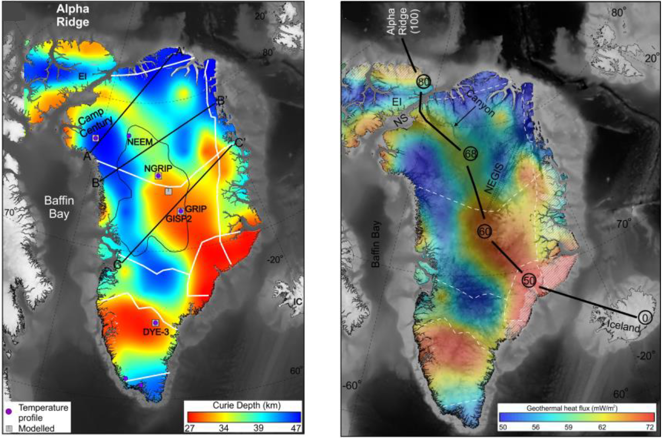
Magnetic anomalies are created by magnetisation induced in magnetic minerals in rocks by the Earth’s magnetic field. Yet minerals lose their ability to be magnetised at temperatures above a threshold known as the Curie point, which is 580 °C for magnetite, the most abundant magnetic mineral. Depending on the geothermal heat flow the Curie point is exceeded at some depth in the lithosphere. So magnetic anomalies can safely be assumed to be produced only by rocks above the so-called Curie depth. Yasmina Martos of the British Antarctic Survey (now at the University of Maryland) and scientists from Britain, the US and Spain used a complex procedure, including gravity data and a few direct measurements of heat flow below Greenland as well as filtered aeromagnetic data, to estimate the variation in Curie depth beneath the ice cap. (Martos, Y.M. et al. 2018. Geothermal heat flux reveals the Iceland hotspot track underneath Greenland. Geophysical Research Letters, v. 45, online publication; doi: 10.1029/2018GL078289). Using that as an inverse proxy for heat flow they were able to map the likely geothermal variation beneath the island. Rather than a random and narrow variation in depth, as would be expected for roughly uniform heat flow, the Curie depth varied in a non-random way by over 20 km, equivalent to roughly 20 mW m-2.
The shallowest Curie depth and highest estimated heat flow occurs in East Greenland around Scoresby Sund where the largest sequence of Palaeocene flood basalts occur. It is also on a line perpendicular to the mid-Atlantic Rift system that meets the active Iceland plume. Running north-west from Scoresby Sund is a zone of locally high estimated heat flow. Martos et al. suggest that this is the track of Greenland’s motion over the Iceland hot spot from about 80 Ma to the period of maximum on-shore volcanism and the start of sea-floor spreading at around 50 Ma.
A fully revised edition of Steve Drury’s book Stepping Stones: The Making of Our Home World can now be downloaded as a free eBook