In early July 2026 I commented on a quite plausible hypothesis that energy from repeated impacts played the primary role in forming the first Hadean crust. That would also help explain why rocks from those early times are vanishingly rare: they may have been remelted and recrystallised numerous times. But there are Hadean zircon grains from the Archaean Jack Hills sandstone of Western Australia that have underpinned a cottage industry for some geochemists for three decades. Such grains must have crystallised from magma, and inherited trace elements from the igneous processes that formed them. An experiment to test the early impact-melt hypothesis appears in a new publication soon to appear in Nature (Szumila, I. and 11 others 2026. A missing continental impact melt sheet signal in the early Earth detrital zircon record. Nature Communications, In press. DOI: 10.1038/s41467-026-76529-w). Led by Ian Szumila of the Carnegie Institute, Washington DC a group of geochemists from the US, UK and Canada compared a range of elements in zircons from the well-established 1.85 Ga impact melt sheet at Sudbury – the largest of its kind preserved on Earth – with those from more typical, internal igneous processes. They used the data from these known settings to ‘train’ a machine-learning model that can be applied to ancient, detrital zircon grains: the ‘unknowns’ with ages between 3.2 to 4.3 Ga.
The Sudbury complex is made up of a basal sheet of mafic igneous rocks (norite and quartz gabbro) and an upper granitic (granophyre) sheet. Essentially, trace-element data from Sudbury zircons result from ‘exogenous’ melting triggered by a massive impact, whereas those formed by internal magmatic processes are of ‘endogenous’ origin. Finding statistically different geochemical features is, however, a tall order as earlier investigations demonstrate. One study comparing the titanium concentration in Sudbury and Hadean zircons found that crystallisation temperatures of those in the accredited impact melt sheet differed from those of Hadean age. This suggested impact melting was not a primary source for the Hadean crystals. Another based on mineral inclusions in the two populations of zircons did support Hadean impact melting, as did a repeat of the Ti approach to crystallisation temperatures. Szumila et al.’s approach using a more sophisticated comparison of a wider range of the zircons’ trace elements seeks to resolve the issue: their U/Yb, Th/U, Yb, and Gd/Yb ratios.
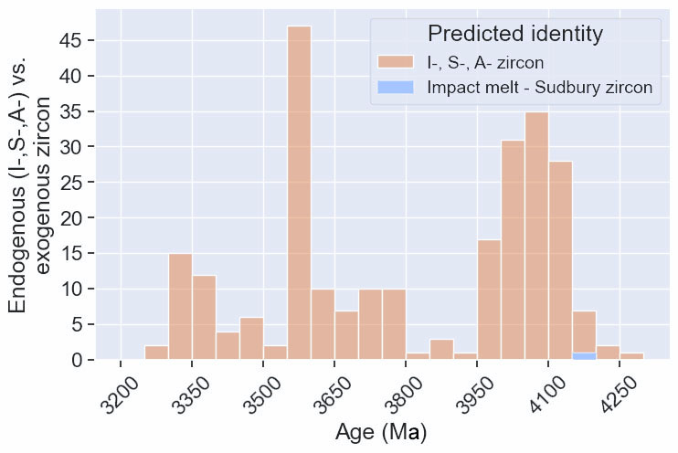
Predicted identity of detrital zircons dated to between 3200 and 4300 Ma: endogenous – pink; exogenous – blue. Credit Szumila et al. Fig 4.
Of the 250 detrital zircon grains dated between 3200 to 4300 Ma-old only a single 4150 Ma-old grain was assigned to an exogenous/impact origin. Apparently, the repeated impact-melt hypothesis for the formation of Earth’s original, Hadean crust is not supported by this experiment. Maybe it did happen, indeed the lunar cratering proxy record for Hadean bombardment of the Earth is unchallengeable. Possibly repeated mega-impacts obliterated and churned up their predecessors’ legacy thereby thermally modifying the tiny zircon grains’ geochemistry before erosion freed them to early and repeatedly reworked sediments. Such a conclusion begs the question of whether or not sustained bombardment repeatedly heated surface water or even boiled it away episodically. On that hangs the vexed question of when self-reproducing organic chemistry was able to result in the earliest life forms: I doubt we will ever know when that fait accompli happened …
The Hadean Eon (~4.6 to 4.0 Ga) is short on rocks that represent it. In fact geologists only know of a single 20 km2 outcrop within that age span (~4.3 Ga): the Nuvvuagittuq Greenstone Belt (~4.3 Ga)on the eastern shore of Hudson Bay. Even that age remains disputed. But a few, tiny detrital zircon grains extracted from much younger sandstones yield an age range up to 4.4 Ga: barely enough to refute James Hutton’s ‘No vestige of a beginning’. So, the Hadean is long on speculation, most based on less than 3% of all the detrital zircon grains that have been dated. What zircons can tell us is based on their isotopic geochemistry, their trace-element content and even tinier granules of a few other minerals that they encapsulate. The data from them suggest the presence of some kind of felsic magma production that crystallised at low temperatures (~700° C) and was exposed to watery fluids. All very vague compared with what can be gleaned with confidence from post-4.0 Ga rock exposures. But there is a sound astronomical context and a theory based on geophysical and geochemical processes known from experiment and observation of later geology, that can shed a little light.
The planetary system began to form by gravitational accretion of material in a protoplanetary disc of pre-solar gas and dust. The first step would have been gravitational sticking together of dust particles. Fast when this cloud was dense but slowing as the available starting material was depleted by growing planetesimals. This early accretion would easily have radiated away the heat generated by the gravitational potential energy that was released. But that became less effective as the accreting bodies grew to sizes of tens to hundreds of kilometres. Studies of meteorites, formed by collisions of larger planetesimals, show that they became hot enough to melt their contents and even to undergo internal, geochemical differentiation. The current view of the next step is that gravitational perturbations associated with Jupiter drove bodies ranging from asteroidal to Mars size into chaotic motion through the Solar System. Assembly of protoplanets thereafter was dominated by collisions. In the case of the proto-Earth this involved its collision with another, Mars-sized body, to result in the formation of the Moon and the early Earth, each initially enveloped by magma oceans. This event can be considered to be the starting point for all subsequent geological processes on both bodies. But that did not ‘calm down’ planetary bombardment. Plenty of large asteroids were still around: their size range can be judged roughly from those that remain in the Asteroid Belt, that are up to 940 km across in the case of the dwarf planet Ceres. This repository of Hadean objects is what motivated Tim Johnson of Curtin University, Western Australia and three Australian colleagues to ponder on the influence on the Hadean Earth of far more bodies, large and small, hurtling around the early Solar System (Johnson, T.E. et al. 2026. Impact heating and the hidden Hadean. Science, v. 392, p. 1408-1412; DOI: 10.1126/science.aeb5402. PDF requests to tim.johnson@curtin.edu.au).
The impact history of the Earth has largely been expunged by tectonics, erosion and sedimentary burial. Johnson et al. assumed an early impact flux from the almost pristine ‘stratigraphy’ of lunar cratering scaled up to the roughly 13 times greater gravitational pull of the Earth. They calculated that energy being released by impacts and partly incorporated into the Earth during the Hadean outweighed that being generated by internal radioactive decay by several orders of magnitude. Hadean tectonics was thus thermally dominated by impact energy, whose supply probably fluctuated wildly because of different sizes of impacting bodies. By far the largest crater on the Moon – the South Pole-Aitken basin – is 2500 km across. It formed about 4.3 Ga ago when a body 200 km wide struck the lunar surface. Being larger and having a greater gravitational pull, Earth would have suffered up to ten collisions of this magnitude.
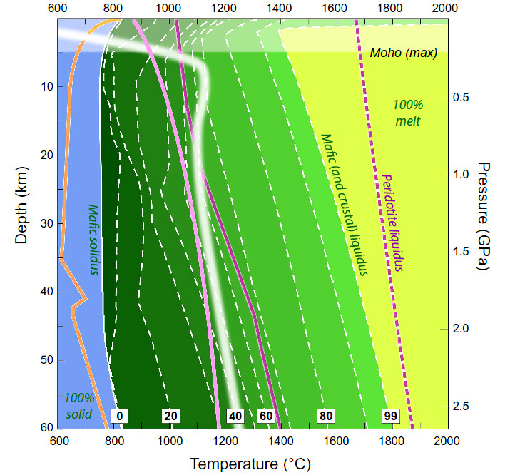
In Archaean and later times tectonics became the main means of shedding ‘smoothly’ generated internal radiogenic heating. Dated lunar rock samples strongly suggest that such awesome bombardment lasted until the early Archaean, around 3.8 Ga ago. Traces of this Late Heavy Bombardment are anomalous tungsten isotopes in gneisses of that age from West Greenland (see: Tungsten and Archaean heavy bombardment; July 2002). Internal heating now governs the physical behaviour of rock: whether it is ductile or brittle. Modern-style lithosphere is brittle, hence plate tectonics. The mantle beneath, in the long term, behaves in a ductile fashion, hence convection. As thermal energy built up with each massive impact neither thermal conduction nor bulk convection in the deeper mantle – i.e. the general state of Earth’s present thermal balance – would have been sufficient to check its effects. Rock would need to melt and magma move rapidly in vast amounts to the surface to dissipate energy by radiation into space: by far the most efficient planet-cooling process. The authors also modelled the geotherm – the variation of temperature with depth – established by conductive heat loss and radiation from the surface under Hadean conditions. This is shown in the figure and explained below.
Melting conditions in an early Hadean basaltic crust. Credit: Johnson et al., Fig 4
The thick white line is the modelled conductive geotherm for the ‘coolest’ impact-heating scenario; a usually safe scientific approach. The thin white line shows beginning of melting of hydrous basaltic crust: the ‘mafic solidus’ – the blue area to its left remains solid. The dark to light green shading towards the right marks increasing percentages of basalt melting in 10% steps (dashed white lines). The palest area at right represents a completely molten crust, beyond the ‘mafic liquidus’. The dashed purple line is the liquidus of mantle peridotite. Moving leftwards, the solid purple, pink and orange lines represent the beginning of melting (solidus) for peridotite, anhydrous basalt and sodium-rich granite respectively
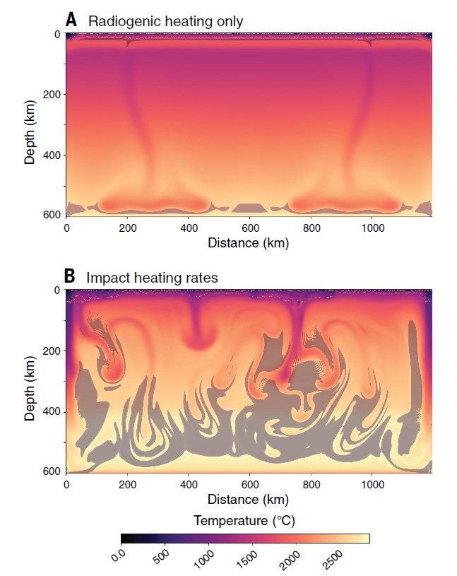
The modelled Hadean geotherm shows very rapid temperature increase down to about 7.5 km. It passes across the solidi of granite, hydrous basalt, anhydrous basalt and mantle peridotite: everything begins to melt. Clearly, whatever its composition, the uppermost Hadean crust would have been in a partially molten condition below about 3.5 km. At depths of 10 km or more, between 40 to 70 % of basalt would be molten. The distinction between brittle and ductile becomes meaningless in the light of Johnson et al.’s analysis of Hadean impact heating. Not only does the modelling rule out any rigid lithosphere and plate tectonics during the Hadean, it also explains the almost complete absence today of tangible Hadean rock. In particular, continental crust dominated by granitic rocks was probably recycled continually and literally into the Hadean ‘melting pot’. Convection would have dominated Hadean tectonics, but rather than taking the modern form of isolated plumes it would have been chaotic.
Simulated convective patterns for a Hadean upper mantle subject only to radiogenic heating (A) compared with its dynamic behaviour when heated by continuous heavy bombardment The grey areas represent dense residues left by very high degrees of partial melting at more shallow depths (B). Credit: Johnson et al., Fig 3 A and B.
Suddenly, beginning about 3.9 Ga a rich record of albeit disputed tectonics emerges during the Palaeoarchaean and then evolves onwards to modern planetary behaviour. The heavy bombardment had stopped.
At the end of the 1970’s I was invited by the Deputy Director of the Geological Survey of India (Southern Region) to participate in the Great Postal Symposium on the Cuddapah Basin: a sort of harbinger of the Internet and Skype, but using snail-mail. Feeling pretty honoured and most intrigued I accepted; not that I knew the first thing about the subject. A regular stream of foolscap mimeographed contributions kept me nipping out of my office to check my pigeon hole for about 6 months. I learned a lot, but felt unable to comment. Four years on I was taken across the Cuddapahs by my first research student – a budding moto-cross driver with a morbid fear of bullock carts – en route from the Archaean low-grade greenstone-granite terrains of Karnataka for a peek at the fabled charnockites near Chennai (then Madras). A bit of a round-about route but spurred by my memories of the Great Postal Symposium. Sadly, the detour was marred for me by a severe case of sciatica brought on by manic driving, the state of the trans-Cuddapah highway and a misplaced gamma-globulin shot to ward off several varieties of hepatitis: I mainly blamed the nurse who demanded that I drop my drawers and bravely take the huge needle in a buttock – they do these things more humanely these days. Anyhow, apart from seeing many dusty villages build of slates perfect enough to make a full-size snooker table, my mind was elsewhere and I have long regretted that.
Landsat image mosaic showing part of the Cuddapah Basin.
Hosting possibly the world’s only diamondiferous Precambrian conglomerate, the Cuddapah Basin contains a 5 km thickness of diverse sedimentary strata, but no tangible fossils. It rests unconformably on the Archaean greenstone-granite terrain of the Dharwar Craton and so is Proterozoic in age; an Eon that spans 2 billion years. The middle of the lowest sedimentary formations (the Papaghni and Chitravati Groups) contains volcanic rocks dated at ~1.9 Ga; another group is cut by a ~1.5 Ga granite, and hitherto the youngest dateable event is the emplacement of 1.1 Ga kimberlites that sourced the diamonds in the conglomerate. Until recently the stratigraphy has been known in some detail, but how to partition it in Proterozoic time is barely conceivable with just three dates in the middle parts that span 800 Ma. All that can be said about the base of the Cuddapah sediments is that they are younger than the 3.1 to 2.6 Ga Archaean rocks beneath. Since the uppermost beds are truncated by a huge thrust system that shoved deep crustal granulites over them their minimum age is equally vague.
Structurally, the Basin began to form on a stable continent underpinned by the Dharwar Craton, but when that collided with Enderbyland in Antarctica, as part of the accretion of the Gondwana supercontinent, sedimentation may have been in an entirely different setting. Indeed, some of the sediments have been carried over the undisturbed part of the basin by a major thrust system. To explore both sedimentary and tectonic evolution Australian, Indian and Canadian geoscientists combined to sample and radiometrically date the entire pile (Collins, A.S. and 13 others 2015. Detrital mineral age, radiogenic isotopic stratigraphy and tectonic significance of the Cuddapah Basin, India. Gondwana Research, v. 28, p. 1294-1309). By precisely dating detrital micas and zircons from the sediments the team was able to check the source region of sedimentary grains as well as to establish a maximum age for each major stratigraphic unit. This helped establish a 3-part sedimentary and tectonic history. The earliest sediments came from the cratonic area to the west, but there are signs that collisional orogeny between 1590 and 1659 Ma produced a new sedimentary source in metamorphic rocks forming to the east. A return to westward provenance marked the youngest sedimentary setting. This enabled the team to suggest a dual evolution of the Basin, first as an extensional rift opening at the east of what is now the Dharwar craton followed by collisional orogeny that transformed the setting to that of a foreland basin, analogous to the Molasse basin in front of the Alps during Cenozoic times, ending with tectonic inversion when extension changed to compression and thrusting.
But to what extent did the work improve the age subdivision of the Cuddapah Basin? Apparently very little, which may be down to a problem with dating detrital minerals. If magmatic and metamorphic evolution was continuous in the areas from which sediments moved, then the youngest grain is a good guide to the maximum age of the sediment being analysed. The more strata are analysed in this way the better the detail of sedimentary timing. But two tectonic terrains are unlikely to produce zircons time and time again during a period approaching a billion years. The data indicate only 3 or 4 episodes of ‘zirconogenesis’ in the sedimentary hinterlands, between about 900 to 1940 Ma. Apart from helping correlate sedimentary formations that were previously deemed stratigraphically different – which did help in tectonically unravelling this complex major feature – several hundred isotopic analyses of zircons and micas have give much the same timing as was known already in more precise terms from stratigraphy assisted by a few dozen conventional radiometric dates.