Curiosity rover hints at the carbon cycle on Mars

The Mars Science Laboratory carried by the Curiosity rover is still functioning 10 years after a jetpack lowered Curiosity onto the surface of Gale crater. It includes a system aimed at scooping and drilling samples of soil and rock from the sedimentary strata deposited in the lake that once filled the crater about 3.5 to 3.8 billion years ago. The system on the rover is also capable of analysing the samples in various ways. A central objective of the mission was to obtain data on oxygen and carbon isotopes in carbon dioxide and methane released by heating samples, which uses a miniature mass spectrometer. In early 2022 a paper on Martian carbon isotopes was published in the Proceedings of the National Academy of Sciences (PNAS) that I have only just found (House, C.H. et al. 2022. Depleted carbon isotope compositions observed at Gale crater, Mars. Proceedings of the National Academy of Sciences, v. 119, article e2115651119; DOI: 10.1073/pnas.2115651119). PNAS deemed it to be one of the 12 most important of its articles during 2022.

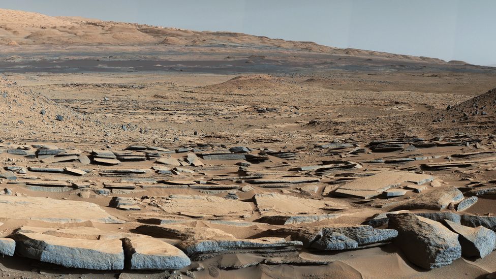
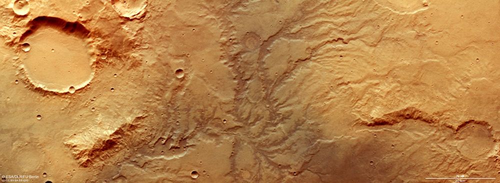
Oblique view of Curiosity’s landing site in Gale crater on Mars, from which the rover has traversed the lower slopes of Mount Sharp. Credit: NASA-Jet Propulsion Laboratory

Carbon isotopic analyses chart the type and degree of fractionation between carbon’s two stable isotopes 12C and 13C. This is expressed by their relative abundances to one another in a sample and in a reference standard, signified by δ13C. The measure is a natural tracer of both inorganic and biological chemical processes: hence the potential importance of the paper by Christopher House and colleagues from the University of California, San Diego. The thin atmosphere of Mars contains both CO2 and traces of CH4, so a carbon cycle is part and parcel of the planet’s geochemical functioning. The ‘big question’ is: Did that involve living processes at any stage in the distant past and even now? Carbon held in various forms within Mars’s ancient rocks and soils may provide at least a hint, one way of the other. At the very least it should say something about the Martian carbon cycle.

House et al. focus on methane released by heating 22 samples drilled from sandstones and mudstones traversed by Curiosity up a slope leading from the floor of Gale crater towards its central peak, Mount Sharp.  The sampled sedimentary rocks span a 0.5 km thick sequence. Carbon in the expelled methane has δ13C values that range from -137 to +22 ‰ (per mil). Samples from six possibly ancient exposed surfaces were below -70 ‰. This depletion in 13C is similar to the highly negative δ13C that characterises carbon-rich sediments on Earth that were deposited at the Palaeocene-Eocene boundary. That anomaly is suspected to have resulted from releases of methane from destabilised gas hydrate on the sea floor during the Palaeocene–Eocene Thermal Maximum. Organic photosynthesis takes up ‘light’ 12C in preference to 13C, thereby imparting low δ13C to organic matter. In the case of the Mars data that might seem to point to the lake that filled Gale crater 3.5 to 3.8 billion years ago has contained living organisms of some kind. Perhaps on exposed surfaces of wet sediment primitive organisms consumed methane and inherited its δ13C. Some Archaean sediments of about the same age on Earth show similar 13C depletion associated with evidence for microbial mats that are attributed to the activities of such methanotrophs.

Before exobiologists become too excited, no images of possible microbial mats in Gale crater sediments have been captured by Curiosity. Moreover, there are equally plausible scenarios with no recourse to once-living organisms that may account for the carbon-isotope data,. Extreme depletion in 13C is commonly found in the carbon within meteorites, almost certainly inherited from the interstellar dust from which they accreted. It is estimated that the solar system passes through giant molecular clouds every 100 Ma or so: the low δ13C may be inherited from interstellar dust. Alternatively, because Mars has an atmosphere almost entirely composed or CO2 – albeit thin at present – various non-biological chemical reactions driven by sunlight or electrically charged particles may have reduced that gas to form methane and other compounds based on C-H bonds. Carbon dioxide still in Mars’s atmosphere is highly enriched in 13C, suggesting that earlier abiotic reduction may have formed 13C-depleted methane that became locked in sediments. Yet such an abundant supply of inorganic methane may have encouraged the evolution of methanotrophs, had life emerged on early Mars. No one knows …

It’s becoming a cliché that, ‘We may have to await the return of samples from the currently active Perseverance rover, or a crewed mission at some unspecifiable time in the future. The Curiosity carbon-isotope data keep the lamp lit for those whose livelihoods have grown around humans going to the Red Planet.

End-Ordovician mass extinction, faunal diversification, glaciation and true polar wander

Enormous events occurred between 460 and 435 Ma around the mid-point of the Palaeozoic Era and spanning the Ordovician-Silurian (O-S) boundary. At around 443 Ma the second-most severe mass extinction in Earth’s history occurred, which eliminated 50 to 60% of all marine genera and almost 85% of species: not much less than the Great Dying at the end of the Permian Period. The event was accompanied by one of the greatest biological diversifications known to palaeontology, which largely replaced the global biota initiated by the Cambrian Explosion. Centred on the Saharan region of northern Africa, Late Ordovician glacial deposits also occur in western South America and North America. At that time all the current southern continents and India were assembled in the Gondwana supercontinent, with continental masses that became North America, the Baltic region, Siberia and South China not far off: all the components that eventually collided to form Pangaea from the Late Silurian to the Carboniferous.

The mass extinction has troubled geologists for quite a while. There are few signs of major volcanism having been involved, although some geochemists have suggested that very high mercury concentrations in some Late Ordovician marine sediments bear witness to large, albeit invisible, igneous events. No large impact crater is known from those times, although there is a curious superabundance of extraterrestrial debris, including high helium-3, chromium and iridium concentrations, preserved in earlier Ordovician sedimentary rocks, around the Baltic Sea. Another suggestion, poorly supported by evidence, is destruction of the atmospheric ozone layer by a gamma-ray burst from some distant but stupendous supernova. A better supported idea is that the oceans around the time of the event lacked oxygen. Such anoxia can encourage solution of toxic metals and hydrogen sulfide gas. Unlike other mass extinctions, this one was long-drawn out with several pulses.

The glacial epoch also seems implicated somehow in the mass die-off, being the only one known to coincide with a mass extinction. It included spells of frigidity that exceeded those of the last Pleistocene glacial maximum, with the main ice cap having a volume of from 50 to 250 million cubic kilometres. The greatest of these, around 445 Ma, involved a 5°C fall in global sea-surface temperatures and a large negative spike in δ13C in carbon-rich sediments, both of which lasted for about a million years. The complex events around that time coincided with the highest ever extinction and speciation rates, the number of marine species being halved in a short space of time: a possible explanation for the δ13 C anomaly. Yet estimates of atmospheric CO2 concentration in the Late Ordovician suggests it was perhaps 8–16 times higher than today; Earth should have been a warm planet then. One probable contributor to extreme glacial conditions has been suggested to be that the South Pole at that time was well within Gondwana and thus isolated from the warming effect of the ocean. So, severe glaciation and a paradoxical combination of mass extinction with considerable biological diversification present quite an enigma.

A group of scientists based in Beijing, China set out to check the palaeogeographic position of South China between 460 and 435 Ma and evaluate those in  O-S sediments at locations on 6 present continents (Jing, X., Yang, Z., Mitchell, R.N. et al. 2022. Ordovician–Silurian true polar wander as a mechanism for severe glaciation and mass extinction. Nature Communications, v. 13, article 7941; DOI: 10.1038/s41467-022-35609-3). Their key tool is determining the position of the magnetic poles present at various times in the past from core samples drilled at different levels in these sedimentary sequences. The team aimed to test a hypothesis that in O-S times not only the entire lithosphere but the entire mantle moved relative to the Earth’s axis of rotation, the ‘slippage’ probably being at the Core-mantle boundary [thanks to Steve Rozario for pointing this out]. Such a ‘true polar wander’ spanning 20° over a mere  2 Ma has been detected during the Cretaceous, another case of a 90° shift over 15 Ma may have occurred at the time when Snowball Earth conditions first appeared in the Neoproterozoic around the time when the Rodinia supercontinent broke up and a similar event was proposed in 1994 for C-O times albeit based on sparse and roughly dated palaeomagnetic pole positions.

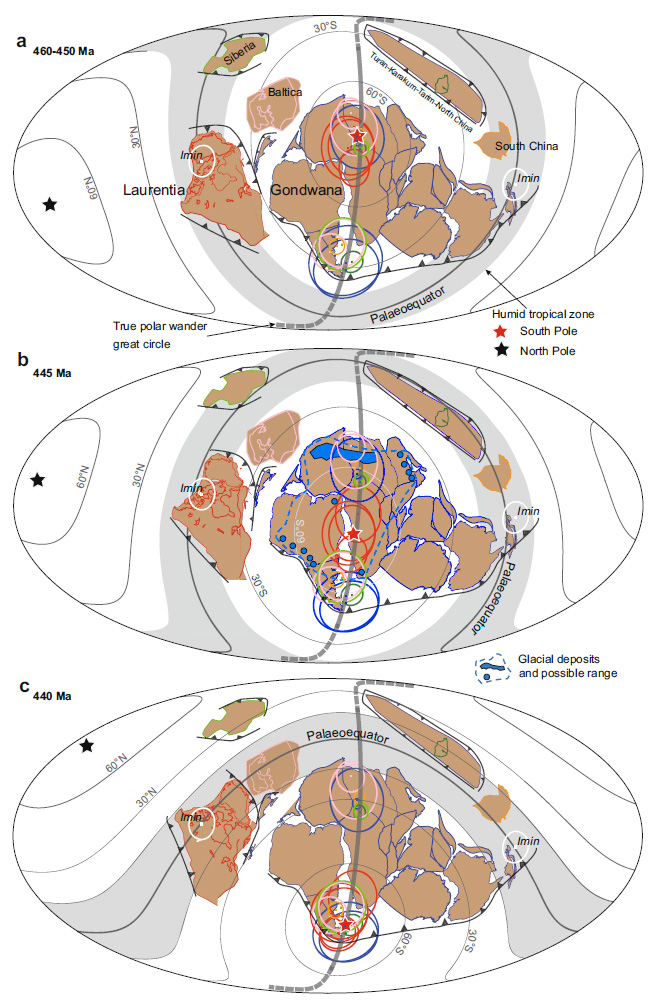
Xianqing Jing and colleagues report a wholesale 50° rotation of the lithosphere between 450 and 440 Ma that would have involved speeds of about 55 cm per year. It involved the Gondwana supercontinent and other continental masses still isolated from it moving synchronously in the same direction, as shown in the figure. From 460 to 450 Ma the geographic South Pole lay at the centre of the present Sahara. At 445 Ma its position had shifted to central Gondwana during the glacial period. By 440 Gondwana had moved further northwards so that the South Pole then lay at Gondwana’s southernmost extremity.

Palaeogeographic reconstructions charting true polar wander and the synchronised movement of all continental masses between 460 and 440 Ma. Note the changes in the trajectories of lines of latitude on the Mollweide projections. The grey band either side of the palaeo-Equator marks intense chemical weathering in the humid tropics. Credit Jing et al. Fig 5.

As well as a possible key to the brief but extreme glacial episode this astonishing journey by a vast area of lithosphere may help account for the mass extinction with rapid speciation and diversification associated with the O-S boundary. While the South Pole was traversing Gondwana as the supercontinent shifted the ‘satellite’ continental masses remained in or close to the humid tropics, exposed to silicate weathering and erosion. That is a means for extracting CO2 from the atmosphere and launching global cooling, eventually to result in glaciation over a huge tract of Gondwana around 445 Ma. Gondwana then moved rapidly into more clement climatic zones and was deglaciated a few million years later. The rapid movement of the most faunally diverse continental-shelf seas through different climate zones would have condemned earlier species to extinction simultaneous adaptation to changed conditions could have encouraged the appearance of new species and ecosystems. This does not require the catastrophic mechanisms largely established for the other mass extinction events. It seems that during the stupendous, en masse slippage of the Earth’s lithosphere plate tectonic processes still continued, yet it must have had a dynamic effect throughout the underlying mantle.

Yet the fascinating story does have a weak point. What if the position of the magnetic poles shifted during O-S times from their assumed rough coincidence with the geographic poles? In other words, did the self-exciting dynamo in the liquid outer core undergo a large and lengthy wobble? How the outer core’s circulation behaves depends on its depth to the solid core, yet the inner core seems only to have begun solidifying just before the onset of the Cambrian, about 100 Ma before the O-S events. It grew rapidly during the Palaeozoic, so the thickness of the outer core was continuously increasing. Fluid dynamic suggests that the form of its circulation may also have undergone changes, thereby affecting the shape and position of the geomagnetic field: perhaps even shifting its poles away from the geographic poles …

Did giant impacts trigger formation of the bulk of continental crust?

Earth is the only one of the rocky Inner Planets that has substantial continental crust, the rest being largely basaltic worlds. That explains a lot. For a start, it means that almost 30 percent of its surface area stands well above the average level of the basaltic ocean basins – more than 5 km – because of the difference in density between continental and oceanic lithosphere. Without continents and the inability of subduction to draw them back  into the mantle  Earth would remain a water-world as it is thought to have been during the Hadean and early Archaean Eons. The complex processes involved in geochemical differentiation and the repeated reworking of the continents through continual tectonic and sedimentary processes has further enriched parts of them in all manner of useful elements and chemical compounds. And, of course, the land has had a huge biosphere since the Devonian period that subsequently helped to draw down CO­2 well as evolving us.

It has been estimated that during the Archaean (4.0 to 2.5 Ga) around 75% of continental crust formed. Much of this Archaean crust is made up of sodium-rich granitoids: grey tonalite-trondhjemite-granodiorite (TTG) gneisses in the main. Their patterns of trace elements strongly suggest that their parent magmas formed by partial melting at shallow depths (25 to 50 km). Their source was probably basalts altered by hydrothermal fluids to amphibolites, unlike the post-Archaean dominance of melting associated with subducted slabs of lithosphere. Yet most of the discourse on early continents has centred on when plate tectonics began and when they became strong enough to avoid disruption into subductible ‘chunks’. Yet 10 years ago geochemists at the University of St Andrews in Scotland used hafnium and oxygen isotopes in Archaean zircons to suggest that the first continents grew very quickly in the Hadean and early Archaean at around 3.0 km3 yr-1, slowing to an average of 0.8 km3 yr-1 after 3.5 Ga. In 2017 Geochemists working on one of the oldest cratons in the Pilbara region of Western Australia developed a new, multistage model for early crust formation that did not have a subduction component. They proposed that high degrees of mantle melting first produced a mafic-ultramafic crust of komatiites, which became the source for a 3.5 Ga mafic magma with a geochemistry similar to those of modern island-arc basalts. If a crust of that composition attained a thickness greater than 25 km and was itself partially melted at its base, theoretically it could have generated TTG magma and Archaean continental crust. Three members of that team from Curtin University, Western Australia, and others have now contributed to formulating a new possibility for early continent formation (Johnson, T.E. et al. 2022.  Giant impacts and the origin and evolution of continents. Nature, v. 608, p. 330–335; DOI: 10.1038/s41586-022-04956-y).

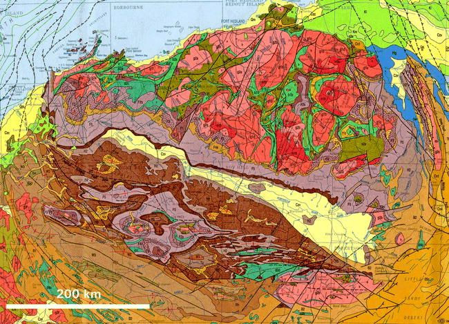
The distinctive Archaean granite-greenstone terrain of the Pilbara craton of Western Australia. TTG granites are shown in reds in the form of domes, which are enveloped by metamorphosed sediments and mafic-ultramafic volcanics in khaki and emerald green. Other colours signify post Archaean rocks. (Credit: Warren B. Hamilton; Earth’s first two billion years. GSA, 2007)

Tim Johnson and colleagues base their views on oxygen isotopes in Archaean zircon grains from the Pilbara. The zircons’ O-isotopes fall into three kinds of cluster: low 18O that indicate a hydrothermally altered source; intermediate 18O suggesting a mantle source; high 18O signifying contamination by metasedimentary and volcanic rocks. The first two alternate in the 3.6 to 3.4 Ga period; 4 clusters with mantle connotations occupy the 3.4 to 3.0 Ga range; a cluster with supracrustal contamination follows 3.0 Ga. This record can be reconciled agreeably with the geological and broad geochemical history of the Pilbara craton. But there is another connection: the Late Heavy Bombardment (LHB) recognised on most rocky bodies in the Solar System.

Bodies with much more sluggish internal processes than the Earth have preserved much of their earliest surfaces and the damage they have suffered since the Hadean. The Moon is the best example. Its earliest rocks in the lunar Highlands record a vast number of impact craters. Their relative ages, deduced from older ones being affected by later ones, backed up by radiometric ages of materials produced by impacts, such as melt spherules and basaltic magmas that flooded the lunar maria, revealed the time span of the LHB. The maria formed between 4.2 and 3.2 billion years ago and the damage done then is shown starkly by the dark maria that make up the ‘face’ of the Man in the Moon. The lunar bombardment was at a maximum between 4.1 and 3.8 Ga but continued until 3.5 Ga, dropping off sharply from its maximum effects. Earth preserves no tangible sign of the LHB, but because it is larger and more massive than the Moon, and both have always been in much the same orbit around the Sun, it must have been subject to impacts on a far grander scale. Projectiles carry kinetic energy that enables them to do geological work when they impact: 1/2 x mass x speed2. The minimum speed of an impact is the same as the target’s escape velocity – 2.4 km s-1 for the Moon and 11.2 km s-1 for the Earth. So the energy of an object hitting the Earth would be 20 times more than if it struck the lunar surface. Taking into account the Earth’s larger cross sectional area, the amount of geological work done here by the LHB would have been as much as 300 times greater than that on Earth’s battered satellite.

The Earth’s early geological history was rarely seen in that context before the 21st century, but that is the framework plausibly adopted by Johnson and colleagues. Archaean  sediments in South Africa contain several beds of impact spherules older than 3.2 Ga, as do those of the Pilbara. The LHB also left a geochemical imprint on Earth in the form of anomalous isotope proportions of tungsten in 3.8 Ga gneisses from West Greenland (See: Tungsten and Archaean heavy bombardment and Evidence builds for major impacts in Early Archaean; respectively, July and August 2002). Johnson et al. suggest a 3-stage process for the evolution of the Pilbara craton: First a giant impact akin to the lunar Maria that formed a nucleus of mafic-ultramafic crust from shallow melting of the mantle; its chemical fractionation to produce low-magnesium basalts; and in turn their melting to form TTG magmas and thus a continental nucleus. They conclude:

‘The search for evidence of the Late Heavy Bombardment on Earth has been a long one. However, all along it seems that the evidence was right beneath our feet.’

I agree wholeheartedly, but would add that, until quite recently, many scientists who referred to extraterrestrial influences over Earth history were either pilloried or lampooned by their peers as purveyors of ‘whizz-bang’ science. So, many ‘kept their powder dry’. The weight of evidence and a reversal of wider opinion over the last couple of decades has made such hypotheses acceptable. But it has also opened the door to less plausible notions, such as an impact cause for sudden climate change and even for mythological catastrophes such as the destruction of Sodom and Gomorrah!

See also: Timmer, J. 2022. Did giant impacts start plate tectonics? arsTechnica 11 August 2022.

Late formation of the Earth’s inner core

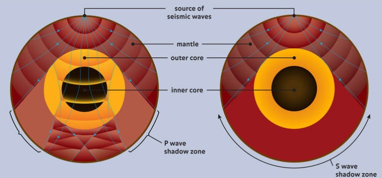
The layered structure of the Earth was discovered using the varying arrival times of seismic waves from major earthquakes, which pass through the Earth, at seismometer stations located across the planet’s surface. Analysis of these arrival times indicates the wavepaths taken through the planet, involving reflections and refractions at boundaries of materials with distinctly different physical properties. S-waves from an earthquake do not arrive in a wide ‘shadow zone’ around its antipode. Since that kind of wave depends on shearing and cannot pass through liquid the shadow reveals the presence of an outer core made of very dense liquid iron and nickel. P-waves that travel in a manner akin to sound waves also show a shadow but it is annular in form around the antipode because of refraction at the core-mantle boundary, but they do penetrate to reach the antipode. However, their arrival times there show faster speeds than expected from an entirely liquid core, and so reveal a central mass, the inner core, which is a ball of solid iron-nickel alloy about 70% of the Moon’s size.

The Earth’s internal structure as revealed by seismic waves (Credit: Smithsonian Institute)

Movements of liquid Fe-Ni in the outer core generate Earth’s magnetic field in the manner of a self-exciting dynamo. Motion in the outer core results from convection of heat from below – probably mainly heat generated by planetary accretion – coupled with the Earth’s rotation and the Coriolis Effect.  The present style of motion is in a thick molten layer trapped between the solid mantle and the inner core. Its circulation results in a magnetic field with two distinct poles close to the geographic ones. The field is crudely similar to that of a bar magnet, with lesser deviations spread around the planet. However, it is not particularly stable, as shown by periodic flips or reversals of polarity through geological time (see: How the core controls Earth’s magnetic field reversals; April 2005).

Few geoscientists doubt that the core formed early in Earth’s history from excess iron, nickel and sulfur, plus other siderophile elements such as gold, that cannot be accommodated by the dominant silicates of the mantle. This could not have been achieved other than by iron-rich melts sinking in some way because of their density. Gradual loss of original heat of accretion and declining radiogenic heat from rare isotopes (e.g. 40K) in the melt suggests an original, totally molten core that at some time began to crystallise under stupendous pressure in its lowest parts. A fully molten core would have been turbulent and therefore able to generate a magnetic field, and Archaean rocks still retain remanent magnetisation. The form that the field took can only be modelled. At times it may have been dipolar – paleomagnetic pole positions match geological evidence for early supercontinents –  and it may have undergone reversals. When the inner core formed has long remained disputed, yet thanks to advances in palaeomagnetic analysis it may now have been resolved  (Zhou, T. and 11 others 2022. Early Cambrian renewal of the geodynamo and the origin of inner core structure. Nature Communications, v. 13, article 4161; DOI:10.1038/s41467-022-31677-7).

Tinghong Zhou of the University of Rochester, USA, and colleagues from other US, Chinese and British institutions have assiduously measured the original magnetic intensities locked in tiny iron- and iron-titanium oxide needles trapped in feldspars that dominate plutonic igneous rocks, known as anorthosites, of late Precambrian age. They found that, by about 565 Ma ago during the Ediacaran Period, the Earth’s magnetic field strength had fallen to almost a sixth of its value in the early Archaean: about 15 times less than it is today. Within a mere 30 Ma it had risen to become 5 times its lowest value , as recorded by a Cambrian anorthosite, and then rose steadily through the Phanerozoic Eon to its present strength. Modelling of the rapid rebound suggests that the inner core had begun to crystallise by about 550 Ma to reach half its present radius by the end of the Ordovician Period (~450 Ma).

That event may also have been a milestone for the continuation of biological evolution on Earth. While Mars once probably had a molten core and magnetic field, it vanished 4 billion years ago, probably when its core became solid. Early Mars had an ocean in its northern hemisphere up to about 3.8 Ga, and there is plenty of evidence for erosion by water on its higher surfaces. For liquid water to have existed there for hundreds of million years demands a thick, warm atmosphere able to initiate a greenhouse effect. With low atmospheric pressure water could have existed only as ice or water vapour. Now its atmosphere is very thin and except at its poles there is no sign of surface water, even as ice (it is possible that significant amounts of water ice remain protected beneath the surface of Mars). One hypothesis is that when Mars lost its magnetic field it also lost protection from the stream of energetic particles known as the solar wind, which can strip water vapour and carbon dioxide – and thus their ability to retain atmospheric heat – from the top of the atmosphere. Earth is currently protected from the solar wind by its strong magnetic field and magnetosphere that deflects high-speed, charged particles. During the Ediacaran Period it almost lost that protection, but was spared by the self-exciting dynamo being regenerated.

See also: How did Earth avoid a Mars-like fate? Ancient rocks hold clues. Science Daily, 25 July 2022

Rare meteorite gives clues to the early history of Mars

Apart from the ages and geochemistry of a few hundred zircon grains we have no direct evidence of what the earliest crust of the Earth was like. The vast bulk of the present crust is younger than about 4 billion years. The oldest tangible crustal rocks occur in the 4.2 billion year (Ga) old Nuvvuagittuq greenstone belt on Hudson Bay. The oldest zircon grains have compositions that suggest that they formed during the crystallisation of andesitic magmas about 4.4 Ga ago about 140 Ma after the Earth accreted. But, according to an idea that emerged decades ago, that does not necessarily represent the earliest geology. Geochemists have shown that the bulk compositions of the Earth and Moon are so similar that they almost certainly share an early history. Rocks from the lunar highlands – the light areas that surround the dark basaltic maria – collected during the Apollo missions are significantly older (up to 4.51 Ga). They are made mainly of calcium-rich feldspars. These anorthosites have a lower density that basaltic magma. So it is likely that the feldspars crystallised from an all-enveloping ‘magma ocean’ and floated to form an upper crust on the moon. Such a liquid outer layer could only have formed by a staggering input of energy. It is believed that what became the Moon was flung from the Earth following collision with another planetary body as vapour, which then collapsed under gravity and condensed to a molten state (see: Moon formed from vapour cloud; January 2008). Crystallisation of the bulk of anorthosites has been dated to between 4.42 to 4.35 Ga (see: Moon-forming impact dated; March 2009). The Earth would likely have had a similar magma ocean produced by the impact (a much fuller discussion can be found here), but no tangible trace has been discovered, though there is subtle geochemical evidence.

The surface geology of Mars has been mapped in great detail from orbiting satellites and various surface Rovers have examined sedimentary rocks – one of them is currently collecting samples for eventual return to Earth. Currently, the only materials with a probable Martian origin are rare meteorites; there are 224 of them out of 61 thousand meteorites in collections. They are deemed to have been flung from its surface by powerful impacts to land fortuitously on Earth. It is possible to estimate when they were ejected from the effects of cosmic-ray bombardment to which they were exposed after ejection, which produces radioactive isotopes of a variety of elements that can be used in dating. So far, those analysed were flung into space no more than 20 Ma ago. Meteorites with isotopic ‘signatures’ and mineral contents so different from others and from terrestrial igneous rocks are deemed to have a Martian origin by a process of elimination. They also contain proportions of noble gases (H, Ne, Ar, Kr and Xe) that resemble that of the present atmosphere of Mars. Almost all of them are mafic to ultramafic igneous rocks in two groups: about 25 % that have been dated at between 1.4 to 1.3 Ga; the rest are much younger at about 180 Ma. But one that was recovered from the desert surface in West Sahara, NW Africa (NWA 7034, nicknamed ‘Black Beauty’) is unique. It is a breccia mainly made of materials derived from a sodium-rich basaltic andesite source, and contains much more water than all other Martian meteorites.

The ‘Black Beauty’ meteorite from Mars (NWA 7035) with a polished surface and a 2 mm wide microscope view of a thin section: the pale clasts are fragments of pyroxenes and plagioclase feldspars; the rounded dark grey clast is a fine-grained basaltic andesite. (Credits: NASA; Andrew Tindall)

If you would like to study the make-up of NWA 7035 in detail you can explore it and other Martian meteorites by visiting the Virtual Microsope devised by Dr Andrew Tindall and Kevin Quick of the British Open University.

The initial dating of NWA 7034 by a variety of methods yielded ages between 1.5 to 1.0 Ga, but these turned out to represent radiometric ‘resetting’ by a high-energy impact event around 1.5 Ga ago. Its present texture of broken clasts set in a fine-grained matrix suggests that the breccia formed from older crustal rock smashed and ejected during that impact to form a debris ‘blanket’ around the crater. Cosmogenic dating of the meteorite indicates that the debris was again flung from the surface of Mars at some time in the last 10 Ma to launch NWA 7034 beyond Mars’s gravitational field eventually to land in northwest Africa. But that is not the end of the story, because increasingly intricate radiometric dating has been conducted more recently.

‘Black Beauty’ contains rock and mineral fragments that have yielded dates as old as 4.48 Ga. So the breccia seems to have formed from fragments of the early crust of Mars. Indeed it represents the oldest planetary rock that has ever come to light. Some meteorites (carbonaceous chondrites) date back to the origin of the Solar System at around 4.56 Ga ago, and were a major contributor to the bulk composition of the rocky planets. However, the material in NWA 7034 could only have evolved from such primordial materials through processes taking place within the mantle of Mars. That was very early in the planet’s history: less than 80 Ma after it first began to accrete. It could therefore be a key to the early history of all the rocky planets, including the Earth.

There are several scenarios that might account for the composition of NWA 7034. The magma from which its components originated may have been produced by direct partial melting of the planet’s mantle shortly after accretion. However, experimental partial melting of ultramafic mantle suggests that andesitic magmas would be unlikely to form by such a primary process. But other kinds of compositional differentiation, perhaps in an original magma ocean, remain to be explored. Unlike the Earth-Moon system, there is no evidence for anorthosites exposed at the Martian surface that would have floated to become crust once such a vast amount of melt began to cool. Some scientists, however, have suggested that to be a possibility for early Mars. Another hypothesis, by analogy with what is known about the earliest Archaean processes on Earth, is secondary melting of a primordial basaltic crust, akin to the formation of Earth’s early continental crust.

Only a new robotic or crewed mission to the area from which NWA 7034  was ‘launched’ can take ideas much further. But where on Mars did ‘Black Beauty’ originate? A team from Australia, France, Cote d’ Ivoire, and the US have used a range of Martian data sets to narrow down the geographic possibilities (Lagain, A., and 13 others 2022. Early crustal processes revealed by the ejection site of the oldest martian meteorite. Nature Communications, v. 13, article 3782; DOI 10.1038/s41467-022-31444-8). The meteorite contains a substantially higher content of the elements thorium and potassium than do other Martian meteorites. Long-lived radioactive isotopes of K, Th and U generate gamma-ray emissions with distinctly different wavelengths and energy levels. Those for each element have been mapped from orbit. NWA 7034 also has very distinct magnetic properties, and detailed data on variations on the magnetic field intensity of Mars have also been acquired by remote sensing. Images from orbit allow relative ages of the surface to be roughly mapped from the varying density of impact craters: the older the surface, the more times it has been struck by projectiles of all sizes. These data also detect of craters large enough to have massively disrupted Martian crustal materials to form large blankets of impact breccias like NWA 7034. That is, ‘targets’ for the much later impact that sent the meteorite Earthwards. Using a supercomputer, Lagain et al. have cut the possibilities down to 19 likely locations. Their favoured source is the relatively young Karratha crater in the Southern Hemisphere to the west of the Tharsis Bulge. It formed on a large ejecta blanket associated with the ancient (~1.5 Ga) 40 km wide Khujirt crater.

Interesting, but sufficiently so to warrant an awesome bet in the form of a mission budget?

A new twist to Pleistocene climate cycles

The combined gravitational pulls of the sun and moon modulate variations in local tidal range. High spring tides occur when the two bodies are opposed at full moon or in roughly the same direction at new Moon. When the positions of sun and moon are at right angles (1st quarter and 3rd quarter) their gravitational pulls partly cancel each other to give neap tides. Consequently, there are two tidal cycles every lunar month.  In a similar way, the varying gravitational pulls of the planets during their orbital cycles impart a repetitive harmony to Earths astronomical behaviour. But their combined effects are on the order of tens of thousand years. Milutin Milankovich (1879-1958), a Serbian engineer, pondered on the possible causes of Earth’s climatic variations, particularly the repetition of ice ages. He was inspired by 19th century astronomers’ suggestion that maybe the gravitational effects of other planets might be a fruitful line of research. Milankovich focussed on how the shape of Earth’s orbit, the tilt of its rotational axis and the way the axis wobbles like that of a spinning top affect the amount of solar heating at all points on the surface: the effects of varying eccentricity, obliquity and precession, respectively.

 Earlier astronomers had calculated cycles of gravitational effects on Earth of the orbits of Jupiter and Saturn of the three attributes of Earth’s astronomical behaviour and found periods of about 100, 41 and 23 thousand years (ka) respectively. The other 3 inner planets and the much more distant giants Uranus and Neptune also have gravitational effects on Earth, but they are negligible compared with those of the two nearest giant planets, because gravitation force varies with mass and inversely with the square of distance. Sadly, Milankovich was long dead when his hypothesis of astronomical climate forcing was verified in 1976 by frequency analysis of the record of oxygen isotopes in foraminifera found in two ocean sediment core from the Southern Indian Ocean. It revealed that all three periods interfered in complex ways during the Late Pleistocene, to dominate variations in sea-surface temperatures and the fluctuating volume of continental ice sheets for which δ18O is a proxy (see: Odds and ends about Milankovich and climate change; February 2017).

Precession of the axis of a spinning top and that of the Earth. At present the northern end of Earth’s axis points to what we now call the Pole Star. Around 11.5 ka from now it will point to the star Vega

This was as revolutionary for climatology as plate tectonics was for geology. We now know that in the early Pleistocene glacial-interglacial cycles were in lockstep with the 41 ka period of axial obliquity, and since 700 ka followed closely – but not perfectly – the 100 ka orbital eccentricity forcing. The transitional period between 1.25 and 0.7 Ma (the Mid-Pleistocene Transition or MPT) suggested neither one nor the other. Milankovich established that axial tilt variations have the greatest influence on solar heating, so the early 41 ka cycles were no surprise. But the dominance of orbital eccentricity on the last 700 ka certainly presented a puzzle, for it has by far the weakest influence on solar heating: 10 times less than those of axial obliquity and precession. The other oddity concerns the actual effect of axial precession on climate change. There are no obvious 23 ka cycles in the climate record, despite the precession signal being clear in frequency analysis and its effect on solar heating being almost as powerful as obliquity and ten times greater than that of orbital eccentricity. Precessional wobbling of the axis controls the time of year when one hemisphere or the other is closest to the Sun. At one extreme it will be the Northern and 11.5 ka later it will be the Southern. The times of solstices and equinoxes also change relative to the calendar that we use today.

There is an important, if obvious, point about astronomical forcing of climate. It is always there, with much the same complicated interactions between the factors: human activities have absolutely no bearing on them. Climatic ‘surprises’ are likely to continue!

Changes in ice-rafted debris (IRD) since 1.7 Ma in a sediment core from the North Atlantic (orange fill) compared with its oxygen-isotope (δ18O) record of changes in continental ice cover (blue fill). At the top are the modelled variations in 23 ka axial precession (lilac) and 41 ka obliquity (green). The red circles mark major interglacial episodes, blue diamonds show the onset of significant ice rafting and orange diamonds are terminations of ice-rafting (TIR). (Credit: Barker et al., Fig. 2)

Sea temperature and ice-sheet volume are not the only things that changed during the Pleistocene. Another kind of record from oceanic sediments concerns the varying proportion in the muddy layers of abnormally coarse sand grains and even small pebbles that have been carried by icebergs; they are known as ice-rafted debris (IRD). The North Atlantic Ocean floor has plenty of evidence for them appearing and disappearing on a layer-by-layer basis. They were first recognised in 1988 by an oceanographer called Helmut Heinrich, who proposed that six major layers rich in IRD in North Atlantic cores bear witness to iceberg ‘armadas’ launched by collapse, or ablation, at the front of surging ice sheets on Scandinavia, Greenland and eastern Canada. Heinrich events, along with Dansgaard-Oeschger events (rapid climatic warming followed by slower cooling) in the progression to the last glacial maximum have been ascribed to a variety of processes  operating on a ‘millennial’ scale. However, ocean-floor sediment cores are full of lesser fluctuations in IRD, back to at least 1.7 Ma ago. That record offers a better chance of explaining fluctuations in ice-sheet ablation. A joint European-US group has investigated their potential over the last decade or so (Barker, S. et al. 2022. Persistent influence of precession on northern ice sheet variability since the early Pleistocene. Science, v. 376, p. 961-967; DOI: 10.1126/science.abm4033). The authors noted that in each glacial cycle since 1.7 Ma the start of ice rafting consistently occurred during a time of decreasing axial obliquity. Yet the largest ablation events were linked to minima in the precession cycles. In the last 700 ka, such extreme events are associated with the terminations of each ice age.

In the earlier part of the record, the 41 ka obliquity ‘signal’ was sufficient to drive glacial-interglacial cycles, hence their much greater regularity and symmetry than those that followed the Mid-Pleistocene Transition. The earlier ice sheets in the Northern Hemisphere also had consistently smaller extents than those after the MPT. Although the records show a role for precession in pre-MPT times in the form of ice-rafting events, the lesser effect of precession on summer warming at higher latitudes, compared with that of axial obliquity, gave it no decisive influence. After 700 ka the northern ice sheets extended much further south – as far as 40°N in North America – where summer warming would always have been commensurately greater than at high northern latitudes. So they were more susceptible to melting during the increased summer warming driven by the precession cycles. When maximum summer heating induced by axial precession in the Northern Hemisphere coincided with that of obliquity the ice sheets as a whole would have become prone to catastrophic collapse.

It is hard to say whether these revelations have a bearing on future climate. Of course, astronomical forcing will continue relentlessly, irrespective of anthropogenic greenhouse gas emissions. Earth has been in an interglacial for the last 11.5 ka, since the Younger Dryas; i.e. about half a precession cycle ago. The combination of obliquity- and precession-driven influences suggest that climate should be cooling and has been since 6,000 years ago, until the Industrial Revolution intervened. Can the gravitational pull of the giant planets prevent a runaway greenhouse effect, or will human effects defy astronomical forces that continually distort Earth’s astronomical behaviour?

Lower-mantle blobs may reveal relics of event going back to the Hadean

The World-Wide Standardised Seismograph Network (WWSSN) records the arrivals of waves generated by earthquakes that have passed through the Earth’s interior. There are two types of these body waves: S- or shear waves that move matter at right angles to their direction of movement; compressional or P-waves that are a little like sound waves as materials are compressed and expanded along the direction of movement. Like sound, P-waves can travel through solids, liquids and gases. Since liquids and gases are non-rigid they cannot sustain shearing, so S-waves only travel through the solid Earth’s mantle but not its liquid outer core. However, their speed is partly controlled by rock rigidity, which depends on the temperature of the mantle; the hotter the lower the mantle’s rigidity.

Analysis of the S-wave arrival times throughout the WWSSN from many individual earthquakes enables seismologists to make 3-D maps of how S-wave speeds vary throughout the mantle and, by proxy, the variation of mantle rigidity with depth. This is known as seismic tomography, which since the late 1990s has revolutionised our understanding of mantle plumes and subduction zones, and also the overall structure of the deep mantle. In particular, seismic tomography has revealed two huge, blob-like masses above the core-mantle boundary that show anomalously low S-wave speeds, one beneath the Pacific Ocean and another at about the antipode beneath Africa: by far the largest structures in the deep mantle. They are known as ‘large low-shear-wave-velocity provinces’ (LLSVPs) and until recently they have remained the enigmatic focus of much speculation around two broad hypotheses: ‘graveyards’ for plates subducted throughout Earth history; or remnants of the magma ocean thought to have formed when another protoplanet impacted with the early Earth to create the Moon about 4.4 billion years ago.

Three-dimensional rendition of seismic tomography results beneath Africa. Mantle with anomalously low S-wave speeds is show in red, orange and yellow. The faint grey overlay represents the extent of surface continental crust today – Horn of Africa at right and Cape Town at the lower margin – the blue areas near the top are oceanic crust on the floor od the Mediterranean Sea. (Image credit: Mingming Li/ASU)

Qian Yuan and Mingming Li of Arizone State University, USA have tried to improve understanding of the shapes of the two massive blobs (Yuan, Q. & Li, M. 2022. Instability of the African large low-shear-wave-velocity province due to its low intrinsic density. Nature Geoscience, v. 15  DOI: 10.1038/s41561-022-00908-3) using advanced geodynamic modelling of the seismic tomography. Their work reveasl that the Pacific LLSVP extends between 500 to 800 km above the core-mantle boundary. Yet that beneath Africa reaches almost 1000 km higher, at 1300 to 1500 km. Both of them are less rigid and therefore hotter than the surrounding mantle. In order to be stable they must be considerably denser than the rest of the mantle surrounding them. But, because it reaches much higher above the core, the African LLSVP is probably less dense than the Pacific one. A lower density suggests two things: the African blob may be less stable; the two blobs may have different compositions and origins.

Both the Pacific Ocean floor and the African continent are littered with volcanic rocks that formed above mantle plumes. The volcanic geochemistry above the two LLSVPs differs. African samples show signs of a source enriched by material from upper continental crust, whereas those from the Pacific do not. Yuan and Li suggest that the enrichment supports the ‘plate graveyard’ hypothesis for the African blob and a different history beneath the Pacific. The 3-D tomography beneath Africa (see above) shows great complexity, perhaps reflecting the less stable nature of the LLSVP. Interestingly, 80 % of the pipe-like African kimberlite intrusions that have brought diamonds up from mantle depths over that last 320 Ma formed above the blob.

But why are there just two such huge blobs of anomalous material that lie on opposite sides of the Earth rather than a continuous anomaly or lots of smaller ones? The subduction graveyard hypothesis is compatible with the last two distributions. In a 2021 conference presentation the authors suggest from computer simulations that the two blobs may have originated at the time of the Moon’s formation after a planetary collision (Yuan, Q. et al. 2021. Giant impact origin for the large low shear velocity provinces. Abstracts for the 52nd Lunar and Planetary Science Conference: Lunar and Planetary Institute, Houston). Specifically, they suggest that the LLSVPs originated from the mantle of the other planet (Theia) after its near complete destruction and melting, which sank without mixing through the magma ocean formed by the stupendous collision. Yet, so far, no geochemists have been bold enough to suggest that there are volcanic rocks of any age that reveal truly exotic compositions inherited from deep mantle material with such an origin. If Theia’s mantle was dense enough to settle through that of the Earth when both were molten, it would be sufficiently anomalous in its chemistry for signs to show up in any melts derived from it. There again, because of a high density it may never have risen in plumes to source any magma that reached the Earth’s surface …

Note added later: Simon Hamner’s Comment about alternative views on seismic tomography has prompted me to draw attention to something I wrote 19 years ago

‘Smoking gun’ for Younger Dryas trigger refuted

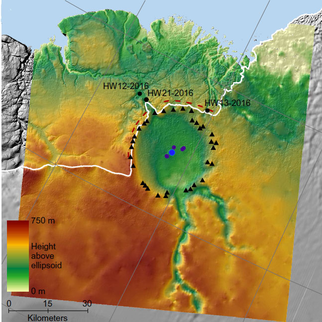
In 2018 airborne ice-penetrating radar over the far northwest of the Greenland revealed an impact crater as large as the extent of Washington DC, USA beneath the Hiawatha Glacier. The ice surrounding it was estimated to be younger than 100 ka. This seemed to offer a measure of support for the controversial hypothesis that an impact may have triggered the start of the millennium-long Younger Dryas episode of frigidity (12.9 to 11.7 ka). This notion had been proposed by a group of scientists who claimed to have found mineralogical and geochemical signs of an asteroid impact at a variety of archaeological sites of roughly this age in North America, Chile and Syria. A new study of the Hiawatha crater by a multinational team, including the original discoverers of the impact structure, has focussed on sediments deposited beyond the edge of the Greenland ice cap by meltwater streams flowing along its base. (Kenny, G.G. et al. 2022. A Late Paleocene age for Greenland’s Hiawatha impact structure. Science Advances, v.8, article eabm2434; DOI: 10.1126/science.eabm2434).

Colour-coded subglacial topography from airborne radar sounding over the Hiawatha Glacier of NW Greenland (Credit: Kjaer et al. 2018; Fig. 1D)

Where meltwater emerges from the Hiawatha Glacier downstream of the crater there are glaciofluvial sands and gravels that began to build up after 2010 when rapid summer melting began, probably due to global warming. As luck would have it, the team found quartz grains that contained distinctive planar features that are characteristic of impact shock. They also found pebbles of glassy impact melts that contain clasts of bedrock, further grains of shocked quartz and tiny needles of plagioclase feldspar that crystallised from the melt. Also present were small grains of the mineral zircon (ZrSiO4), both as pristine crystals in the bedrock clasts and porous, grainy-textured grains showing signs of deformation in the feldspathic melt rock. So, two materials that can be radiometrically dated are available: feldspars suitable for the 40Ar/39Ar method and zircons for uranium-lead (U-Pb) dating. The feldspars proved to be about 58 million years old; i.e. of Late Palaeocene age. The pristine zircon grains from bedrock clasts yielded Palaeoproterozoic U-Pb ages (~1915 Ma), which is the general age of the Precambrian metamorphic basement that underpins northern Greenland. The deformed zircon samples have a very precise U-Pb age of 57.99±0.54 Ma. There seems little doubt that the impact structure beneath the Hiawatha Glacier formed towards the beginning of the Cenozoic Era.

During the Palaeocene, Northern Greenland was experiencing warm conditions and sediments of that age show that it was covered with dense forest. The group that since 2007 has been advocating the influence of an impact over the rapid onset of the Younger Dryas acknowledges that the Hiawatha crater cannot support their view. But they have an alternative: an airburst of an incoming projectile. Although scientists know such phenomena do occur, as one did over the Tunguska area in Siberia on the morning of 30 June 1908. Research on the Tunguska Event has discovered  geochemical traces that may implicate an extraterrestrial object, but coincidentally the area affected is underlain by the giant SIberian Traps large igneous province that arguably might account for geochemical anomalies. Airbursts need to have been observed to have irrefutable recognition. Two posts from October 2021 – A Bronze Age catastrophe: the destruction of Sodom and Gomorrah? and Wide criticism of Sodom airburst hypothesis emerges – suggest that some scientists question the data used repeatedly to infer extraterrestrial events by the team that first suggested an impact origin for the Younger Dryas.

See also: Voosen, P, 2022. Controversial impact crater under Greenland’s ice is surprisingly ancient. Science, v. 375, article adb1944;DOI: 10.1126/science.adb1944

End-Cretaceous mass extinction occurred in northern spring

This post’s title seems beyond belief for an event that occurred 66 million years ago: how can geologists possibly say that with any conviction? The claim is based on fossil fishes found in the Late Cretaceous Hell Creek Formation of North Dakota (see: A bad day at the end of the Cretaceous. April, 2019), described in a paper published on 1 April 2019. The horizon that displays all the classic evidence for an impact origin for the K-Pg extinction is a freshwater sediment laid down by a surge into a river system: the upstream result of the mega-tsunami driven by the Chicxulub impact in the Gulf of Mexico. Amongst much else it contains intact marine ammonites – the last of their kind – and freshwater paddlefish and sturgeon. The fishes are preserved exquisitely, with no sign of scavenging. Parts of their gills are clogged with microscopic spherules made of impact glass. They are pretty good ‘smoking guns’ for an impact, and are accompanied by dinosaur remains – an egg with an embryo, hatchlings and even a piece of skin.

A group of scientists from the Netherlands, Sweden, Belgium and the UK examined thin sections of the fishes’ bones (During, M.A.D. et al. 2022. The Mesozoic terminated in boreal springNature online publication, 23 February 2022; DOI: 10.1038/s41586-022-04446-1). These revealed growth layers that show lines of arrested growth (LAGs) separated by thicker layers. Such LAGs in modern paddlefish and sturgeon bones may indicate conditions of low food availability in winter, most growth being during warmer times of year. Each bone that was examined has only a thin outer zone of accelerated growth following its last LAG. So it seems that each specimen died in the Northern Hemisphere spring. This was confirmed by variations within the cyclic zonation of the relative proportions of carbon isotopes 13C and 12C, expressed as δ13C. In the LAGs δ13C is lower than in the thicker zones, which is consistent with decreased prey availability in winter, but see below.

Thin sections of fish bones from the K-Pg boundary layer in the Hell Creek Formation, showing lines of arrested growth marked by red arrowheads. The outermost (top) LAGs are succeeded by only a thin zone of accelerated growth during their last weeks of the fishes’ lives (credit: During et al., Fig. 2)

The paper by During et al. follows one with very similar content from the same deposit that was published about 12 weeks earlier (DePalma, R.A., et al. 2021. Seasonal calibration of the end-cretaceous Chicxulub impact event. Nature Science Reports, v. 11, 23704; DOI: 10.1038/s41598-021-03232-9). Yet During et al. do not refer to it, despite acknowledging DePalma’s guidance in the field and his granting access to his team’s specimens: maybe due to poor communications … or maybe not. DePalma et al. note thatmodern sturgeons are able to spend winters in the sea, which may also explain the low δ13C in the LAGs, as well as decreased prey availability does. They also examined damage by leaf-mining insects in fossil leaves at the site, which supports the springtime extinction hypothesis. Another study in DePalma et al. is the size range of newly hatched fish of three different Families that are founds as fossils in the K-Pg deposit. By comparing them with the growth histories of closely-related modern hatchlings they conclude that perhaps late spring to early summer is implied. Whatever, both papers go on to discuss the implications of their basic conclusions. Spring is a particularly sensitive time for the life cycles of many organisms; i.e. annual reproduction and newborns’ early growth. But some groups of egg-laying animals, such as perhaps dinosaurs, require longer incubation periods than do others, e.g. birds, and may be more vulnerable to rapid environmental change. That may explain the demise of the dinosaurs while their close avian relatives, or at least some of them, survived.  Yet the season in the Southern Hemisphere when the Chicxulub impact occurred would have been autumn. That may go some way towards explaining evidence that ecological recovery from mass extinction in the southern continents seems to have been faster. Almost certainly, the impact would have induced a double climatic whammy: warming in its immediate aftermath followed by global cooling plus a shutdown of photosynthesis as dust clouds enveloped the planet. Then there is the issue of contamination by potentially toxic compounds raised by Chicxulub. The K-Pg boundary seems likely to run and run as a geoscientific story more than four decades since it was first proposed.

See also: Sample, I. 2022. Springtime asteroid ramped up extinction rates, say scientists. The Guardian, 23 September 2022.

A cometary air-burst over South America 12 thousand years ago

Earth-logs has previously covered quite a few hypotheses involving catastrophic astronomical events of the past, often returning to them as new data and ideas emerge. They range from giant impacts, exemplified in the mass extinction at the K-Pg boundary to smaller-scale events that may have coincided with important changes in climate, such as the sudden onset of the Younger Dryas, and a few that have been suggested as agencies affecting local human populations such as the demise of Sodom by a cosmogenic air-burst. Some of the papers that spurred the Earth-pages posts have been widely regarded in the geoscience community. Yet there have been others that many have doubted, and even condemned. For instance, data used by the consortium that suggested an extraterrestrial event triggered the frigid millennium of the Younger Dryas (YD) have been seriously and widely questioned. A sizeable number of the team that were under close scrutiny in 2008 joined others in 2019 to back the YD air-burst hypothesis again, using similarly ‘persuasive’ data from Chile. Members of the original consortium of academics also contributed to the widely disputed notion of a cosmic air-burst having destroyed a Bronze Age urban centre in Jordan that may, or may not, have been the site of the Biblical Sodom. Again, they cited almost the ‘full monty’ of data for high-energy astronomical events, but again no crater or substantial melt glass, apart from tiny spherules. Now another paper on much the same theme, but none of whose authors contributed to those based on possibly ‘dodgy’ data, has appeared in Geology (Schultz, P.H. et al. 2021. Widespread glasses generated by cometary fireballs during the Late Pleistocene in the Atacama Desert, Chile. Geology, published online November 2, 2021; doi: 10.1130/G49426.1).

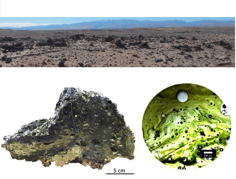
Peter Schultz of Brown University, USA and colleagues from the US and Chile make no dramatic claims for death and destruction or climate destabilisation, and simply report a fascinating discovery. In 2012 one of the authors, Nicolas Blanco of the Universidad Santo Tomás in Santiago, Chile, found slabs made of glassy material up to half a metre across. They occurred in several 1 to 3 km2 patches over a wide area of the Atacama Desert. Resting on Pleistocene glacio-fluvial sediments, they had been exposed by wind erosion of active sand dunes. The glass is dark green to brown and had been folded while still molten. For the glass slabs to be volcanic bombs presupposes a nearby volcano, but although Chile does have volcanoes none of the active vents are close enough to have flung such large lumps of lava into the glass-strewn area. The glassy material also contains traces of vegetation, and varies a great deal in colour (brown to green). Its bulk chemical composition suggests melting of a wide variety of surface materials: quite unlike volcanic glasses.

Chilean glass occurrence: panorama of large glass fragments in the Atacama Desert; a specimen of the glass; thin section of glass showing bubbles and dusty particles (Credit: Schultz et al. 2021; Figs 1B, 2D and 2C)

Microscopic examination of thin sections of the glasses also reveals nothing resembling lava, except for gas bubbles. The slabs are full of exotic fragments, some of which closely resemble mineral assemblages found in meteorites, including nickel-rich sulfides embedded in ultramafic material. Others are calcium-, aluminium- and titanium-rich inclusions, such as corundum (Al2O3) and perovskite (CaTiO3), thought to have originated as very-high temperature condensates from the pre-solar nebula: like the celebrated ‘white inclusions’ in the Allende meteorite. Some minute grains resemble dust particles recovered by the NASA Stardust mission to Comet 81P/Wild-2 which returned samples to Earth in 2006. Zircon grains in the glasses, presumed to be locally derived, have been decomposed to zirconium oxide (baddeleyite), suggesting melting temperatures greater than 1670°C: far above the highest temperature found in lavas (~1200°C). Interestingly, the green-yellow silica glass strewn over the Sahara Desert around the southern Egypt-Libya border also contains baddeleyite and cometary dusts, together with anomalously high platinum-group elements and nanodiamonds that are not reported from the Chilean glass. Much prized by the elite of pharaonic Egypt and earlier makers of stone tools, the Saharan glass is ascribed to shock heating of the desert surface by a cometary nucleus that exploded over the Sahara. Unsurprisingly, Schultz et al. come to the same conclusion.

Any object entering the Earth’s atmosphere does so at speeds in excess of our planet’s escape velocity (11.2 km s-1). Not only does that result in heating by friction with the air, but much of the kinetic energy of hypersonic entry goes into compressing air through shock waves, especially with objects larger than a few tens of metres. Such adiabatic compression can produce temperatures >>10 thousand °C. Hence the ‘fireballs’ associated with large meteorites. With very large air-bursts the flash of radiant energy would be sufficient to completely melt surface materials in microseconds, though rugged topography could protect areas shadowed from the air-burst by mountains, perhaps explaining the patchy nature of the glass occurrences.  (Note: the aforementioned papers on the YD and Sodom ‘air-bursts’ do not mention large glass fragments, whereas some surface melting would be expected). Some of the Chilean glass contains carbonised remnants of vegetation. Radiocarbon dating of four samples show that the glass formed at some time between 16.3 to 12.1 ka. Yes, that does include the age of the start of the YD (12.9 ka) and human migrants had established themselves in northern Chile and coastal Peru after 14.2 ka. Yet the authors, perhaps wisely, do no more than mention the coincidence, as well as that with the disappearance of South American Pleistocene megafaunas – more severe than on any other continent. With a very distinctive product, probably spanning a far larger area of South America, and attractive to humans as an ornament or a resource for sharp tools, expect follow-up articles in the future.

See also: http://www.sci-news.com/space/atacama-desert-comet-10247.html, Science News, 8 November 2021; Vast patches of glassy rock in Chilean desert likely created by ancient exploding comet, Eureka Alert, 2 November 2021.

Pinpointing the source of Martian meteorites and a stab at magmatism on Mars

Most meteorites found on the Earth’s surface are fragments of small bodies left over from the accretion of the planets around 4.5 billion years ago, thanks largely to collisions among larger, asteroid-sized bodies. A minority have other origins: some as debris from otherwise icy comets and a few that have been flung off other rocky planets or large moons by crater-forming impacts. Meteorites suspected to have originated through impact are ‘rocky’ – i.e.  made of silicates – and have textures and mineral contents suggesting they formed late in planetary evolution. Most are igneous with basaltic or ultramafic composition: respectively lavas and cumulates formed in magma chambers. Some are breccias, hinting at a pyroclastic origin. The radiometric ages of such planetary fragments are generally far younger than the times when the solar system and planets formed.  Almost 300 have been classified as coming from Mars, only two of which are older than 1400 Ma. The most numerous group of Martian meteorites, known as shergottites, crystallised between 575 and 150 Ma ago to form crust of igneous origin. During the journey from their source to Earth meteorites are exposed to high-energy cosmic rays that generate a variety of new isotopes, from whose relative proportions their travel time can be estimated. The shergottites all seem to have been blasted from Mars a mere 1.1 Ma ago, suggesting that a single impact launched them. So, identifying their source crater on Mars would enable the shergottites to be treated in the same way as samples collected by geologists from a small locality on Earth. Their geochemistry should give important clues to processes within Mars over a time period that spans the late-Precambrian to early Cretaceous on Earth.

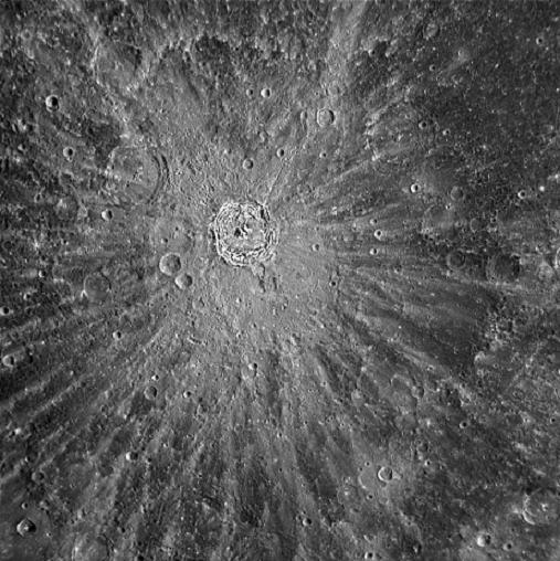
Kuiper crater on the Moon, with rays and secondary craters. (Credit: NASA/Johns Hopkins University, USA)

There are many craters on Mars, so homing-in on a single source for shergottite meteorites might seem a tall order. A strategy for doing that depends on recognising craters formed by impacts with sufficient energy to eject debris at the escape velocity from Martian gravity: about 5 km s-1 compared with 11 km s-1 for Earth. Calculations suggest that such impacts would produce craters larger than 3 km across. Large ejecta travelling at slower speeds from them would fall back to produce smaller craters arranged radially from the main crater, forming distinctive rays. Anthony Lagain and colleagues from Curtin University, Western Australia and other institutions in Australia, USA, France and Côte d’ Ivoire adapted a detection algorithm to locate craters less than 1 km across that formed in rays around larger craters (Lagain, A. and 10 others 2021. The Tharsis mantle source of depleted shergottites revealed by 90 million impact craters. Nature Communications, v. 12, article6352; DOI: 10.1038/s41467-021-26648-3). They used 100 m resolution images of thermal emission from the Martian surface that most clearly distinguish large craters that have ejecta deposits around them. Then they turned to images with 0.25 m resolution covering the visible spectrum that can spot very small craters. The authors’ analysis compiled around 90 million impact craters smaller than 300 metres across (a quarter the size of the celebrated Meteor Crater in Arizona).

Laser-altimetry data that show two large impact craters and their ejecta aprons on the Tharsis Plateau of Mars and two of its huge volcanoes: grey-brown-red-orange-yellow-green = high-to-low elevations. (Credit: NASA / JPL-Caltech / Arizona State University)

Dust storms on Mars gradually fill and obscure small craters and ejecta rays, so the younger the impact event, the more visible are rays and secondary small craters. Luckily, just two large craters on Mars have well-preserved rays that contain high densities of small secondary craters. Both of them lie on the Tharsis Plateau near the Martian Equator. This is a vast bulge on the planet’s surface – 5000 km across and rising to 7 km – characterised by three enormous shield volcanoes that rise to 18 km above the average elevation of Mars. The authors judge that one or the other crater is the source for shergottite meteorites, and that this meteorite class collectively samples the most recent igneous rocks that form the Tharsis Plateau. So vast is its mass, that the plateau has probably built-up over most of Mars’s history. One hypothesis is that the bulging has progressively developed over a huge thermal anomaly that has supported a mantle superplume for billions of years from which basaltic magma has steadily moved to the surface.

This model of a perpetual hot spot beneath Tharsis implies that the magmas that it has generated in the past have progressively depleted the underlying mantle in the incompatible trace elements that preferentially enter magma rather than remaining in solid minerals during partial melting. Having been able to suggest that the 575 to 150 Ma-old shergottites represent the upper crust of Tharsis that formed at that late stage in its history, Lagain et al. use those meteorites’ well-established trace-element geochemistry to test that hypothesis. They do indeed suggest their derivation by partial melting of mantle rocks that had in earlier times been strongly depleted in incompatible elements. One of the greatest mysteries about Mars’ evolution may have been resolved without the need for a crewed mission.

Multiple impacts set back oxygen build-up in the Archaean

Earth’s present atmosphere contains oxygen because of one form of photosynthesis that processes water and carbon dioxide to make plant carbohydrates, leaving oxygen at a waste product. The photochemical trick that underpins oxygenic photosynthesis seems only to have evolved once. It was incorporated in a simple, single-celled organism or prokaryote, which lacks a cell nucleus but contains the necessary catalyst chlorophyll. Such an organism gave rise to cyanobacteria or blue-green bacteria, which still make a major contribution to replenishing atmospheric oxygen. Chloroplasts that perform the same function in plant cells are so like cyanobacteria that they were almost certainly co-opted during the evolution of a section of nucleus-bearing eukaryotes that became the ancestors of plants. A range of evidence suggests that oxygenic photosynthesis appeared during the Archaean Eon, the most tangible being the presence of stromatolites, which cyanobacteria mats or biofilms form today. These knobbly structures in carbonate sediments extend as far back as 3.5 billion years ago (see: Signs of life in some of the oldest rocks; September 2016). Yet it took a billion years before the first inklings of biogenic oxygen production culminated in the Great Oxygenation Event or GOE (see: Massive event in the Precambrian carbon cycle; January, 2012) at around 2400 Ma. Then, for the first time, oxidised iron in ancient soils turned them red. If oxygen was being produced, albeit in small amounts, in shallow, sunlit Archaean seas, why didn’t it build up in the atmosphere of those times? Geochemical analyses of Archaean sediments do point to trace amounts, with a few ‘whiffs’ of more substantial amounts. But they fall well below those of Meso- and Neoproterozoic and Phanerozoic times. One hypothesis is that Archaean oceans contained dissolved, ferrous iron (Fe2+) – a powerful reducing agent – with which available oxygen reacted to form insoluble ferric iron (Fe3+) oxides and hydroxides that formed banded iron formations (BIFS). The Fe2+ in this hypothesis is attributed to hydrothermal activity in basaltic oceanic crust. There is, however, another possibility for suppression of atmospheric oxygen accumulation in the Archaean and early-Palaeoproterozoic.

Summary of the evolution of atmospheric oxygen and related geological features. The percentage scale is logarithmic with the modern level being100%. Credit Alex Glass, Duke University

Simone Marchi of the Southwest Research Institute of Boulder, CO, USA and colleagues from the US, Austria and Germany suggest that planetary bombardment offers a plausible explanation (Marchi, S. et al 2021. Delayed and variable late Archaean atmospheric oxidation due to high collision rates on Earth. Nature Geoscience, v. 14 advance publication; DOI: 10.1038/s41561-021-00835-9). Over the last 20 years evidence of extraterrestrial impacts has emerged, in the form of thin spherule-bearing layers in Archaean sedimentary strata, probably formed by impacts of objects around 10 km across. So far 35 such layers have been identified from several locations in South Africa and Western Australia. They span the last billion years of the Archaean and the earliest Palaeoproterozoic, although they are not evenly spaced in time. The spherules represent droplets of mainly crustal but some meteoritic rocks that were vaporised by impacts and then condensed as liquid. Meteorites in particular contain reduced elements and compounds, including iron, whose oxidation by would remove free oxygen.

The evidence from spherule beds is supplemented by the team’s new calculations of the likely flux of impactors during the Archaean. These stem from re-evaluation of the lunar cratering record that is used to estimate the number and size of impacts on Earth up to 2.5 Ga ago. This flux amounts to the ‘leftovers’ of the catastrophic period around 4.1 Ga when the giant planets Jupiter and Saturn ran amok before they settled into their present orbits. Their perturbation of gravitational fields in the solar system injected a long-lived supply of potential impactors into the inner solar system, which is recorded by craters on the post-4.1 Ga lunar maria. The calculations suggest that the known spherule layers underestimate the true number of such collisions on Earth. Modelling by Marchi et al., based on the meteorite flux and the oxidation of vaporised materials produced by impacts, plausibly accounts for the delay in atmospheric oxygen build-up.

It is worth bearing in mind, however, that large impacts and their geochemical aftermath are, in a geological sense, instantaneous events widely spaced in time. They may have chemically ‘sucked’ oxygen out of the Archaean and early-Palaeoproterozoic atmosphere. Yet photosynthesising bacteria would have been generating oxygen continuously between such sudden events. The same goes for the supply of reduced ferrous iron and its circulation in the oceans of those times, capable of scavenging available oxygen through simple chemical reactions. In fact we can still observe that in action around ocean-floor hydrothermal vents where a host of reduced elements and compounds are oxidised by dissolved oxygen. The difference is that oxygen is now produced more efficiently on land and in the upper oceans and a less vigorous mantle is adding less iron-rich basalt magma to the crust: the balance has changed. Another issue is that the Great Oxygenation Event terminated the oxygen-starved conditions of the Archaean and Palaeoproterozoic in about 200 million years, despite the vast production of BIFs before and after it happened. The Wikipedia entry for the GOE provides a number of hypotheses for how that termination came about. Interestingly, one idea looks to a shortage of dissolved nickel that is vital for methane generating bacteria: a nickel ‘famine’. A geochemical setback for methanogens would have been a boost for oxygenic photosynthesisers and especially their waste product oxygen: methane quickly reacts with oxygen in the atmosphere to produce CO2 and water. Anomalously high nickel is a ‘signature element’ for meteorite bombardment, though it can be released by hydrothermal alteration of basalt. Had meteoritic nickel been fertilising methane-generating bacteria in the oceans prior to the GOE?

See also: A new Earth bombardment model. Science Daily, 21 October 2021.

Climate change reducing Earth’s albedo

According to a new study (Goode, P. R.et al. 2021. Earth’s albedo 1998–2017 as measured from earthshine. Geophysical Research Letters, v. 48, article e2021GL094888; DOI: 10.1029/2021GL094888) the ability of the Earth to reflect solar radiation back into space has been decreasing significantly over the last two decades. The conclusion has arisen from measurements of the brightness of the lunar surface. A new Moon is barely visible, apart from a thin sliver illuminated by the Sun. Its overall faint brightness is due to sunlight reflected from the Earth’s surface that faces the Moon: so-called ‘earthshine’. New Moons occurs when it is above the lit side of the Earth, so they appear during daylight hours. Earthshine depends on the ability of the Earth’s surface and cloud cover to reflect solar radiation, or its albedo. Albedo was high during the last ice age because of continental ice sheets and it can also occur when there is an unusually large percentage of cloud cover or a lot of dust and aerosols in the atmosphere, perhaps after a large volcanic eruption. High albedo leads to global cooling. Decreased albedo allows the atmosphere to heat up, and conspires with the greenhouse effect to produce global warming.

Philip Goode and his colleagues measured earthshine on the Moon between 1998 and 2017 to precisely determine daily, monthly, seasonal, yearly and decadal changes in terrestrial albedo. The Earth reflects roughly 30% of the solar energy that falls on it, although it varies with Earth’s rotation, depending on the proportion of land to ocean that is sunlit. Over the two decades earthshine decreased gradually by ~0.5 W m-2, indicating a 0.5% decrease in Earth’s albedo and a corresponding increase in the amount of solar energy received at the land and ocean surfaces. To put this in perspective the estimated warming from anthropogenic greenhouse emissions over the same period increased by just a little more (0.6 W m-2). Albedo decrease is reinforcing the greenhouse effect.

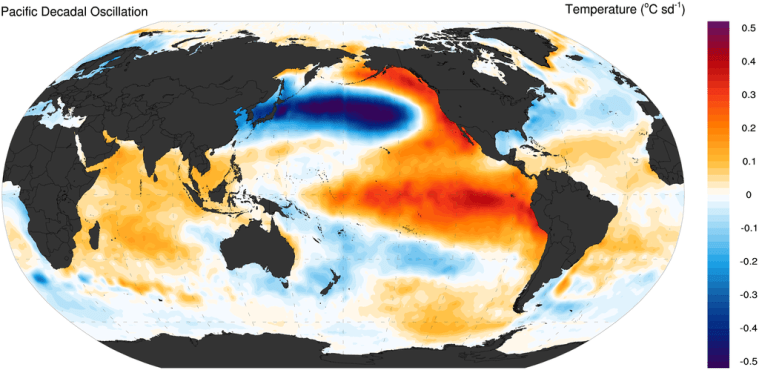
Sea-surface temperature anomalies over the Pacific Ocean during a ‘positive’ phase of the Pacific Decadal Oscillation – reversal to a ‘negative’ phase cools the eastern Pacific and warms the west (Credit: Wikipedia)

Although it might seem that increased seasonal melting of polar sea ice would have the main effect on albedo, this is not borne out by the earthshine data. What is strongly implicated is a decrease over the Eastern Pacific Ocean of highly reflective low-altitude clouds. That might seem counterintuitive, since warming of the sea surface increases evaporation, but the reduced low-cloud cover has been measured from satellites. Many scientists and most climate-change deniers have thought that an increase in cloud cover at low latitudes and thus albedo would moderate surface warming. The opposite seems to be happening. The key may lie in one of the Earth’s largest climate phenomena, the Pacific Decadal Oscillation (PDO). This has a major effect on global climate through long-distance connections (teleconnections) to other climatic processes. The satellite data hint at the changes in albedo of the Western Hemisphere having been related to a long-term reversal in the PDO. The Earth’s climate system increasingly reveals its enormous complexity.

See also: Earth is dimming due to climate change, Science Daily, 30 September 2021.

Tectonics on Venus

The surface of Venus is not easily observed because of the almost opaque nature of its atmosphere. The planet is veiled by a mixture of CO2 (96.5%) and nitrogen (3.5%), with a little sulfur dioxide and noble gases. The atmosphere’s mass is almost 100 times that of the Earth’s, and has a density about 6.5% that of liquid water at the surface. The opacity stems from a turbulent upper layer of mainly sulfuric acid. Venus is the victim of runaway greenhouse conditions. Despite that, radar can penetrate the atmosphere to reveal details of its surface morphology – roughness and elevation – at a spatial resolution of 150 m. Although coarser than that available from radar remote sensing of the Earth from orbit, the Magellan data are still geologically revealing.

Earlier interpretation of Venus radar images revealed the surface to be far simpler than that of the Earth, Mars and all other rocky bodies in the Solar System. Yet it has more volcanoes than does the Earth or Mars. However, despite being subject to very little erosion – Venus is a dry world – only around 1000 impact craters have been found: far short of the number seen on Mars or the Moon. This deficiency of evidence for bombardment suggests that Venus was ‘repaved’ by vast volcanic outpourings in the geologically recent past, estimated to have occurred 300 to 600 Ma ago. This early work concluded that plate tectonics was absent; indeed that for half a billion years the lithosphere on Venus had been barely deformed. It has been suggested that Venus has been involved in megacycles of sudden, planet-wide magmatic activity separated by long periods of quiescence. This could be attributed to the lack of plate tectonics, which is the principal means that Earth continuously rids itself of heat produced at depth by decay of radioactive isotopes in the mantle. Venus has been suggested to build up internal temperatures until they reach a threshold that launches widespread partial melting of its mantle. Planet-wide eruption of magma then reduces internal temperatures.

Polygonal blocks or ‘campuses’ on the lowland surface of Venus. Note the zones of ridges that roughly parallel ‘campus’ margins. Credit: Paul K. Byrne, North Carolina State University and Sean C. Solomon, Lamont-Doherty Earth Observatory

It comes as a surprise that 26 years after Magellan plunged into the Venusian atmosphere new interpretation of its radar images suggests a completely different scenario (it may be that academic attention generally switched to research on Mars because of all the missions to the ‘Red Planet’ since Magellan disappeared). It is based on features of the surface of Venus so large that their having been missed until now may be a planetary-scale example of ‘not seeing the woods for the trees’! Geoscientists from the US, Turkey, the UK and Greece have mapped out features ranging from 100 to 1000 km across that cover the lowland parts of Venus (Byrne, P.K. et al. 2021. A globally fragmented and mobile lithosphere on Venus. Proceedings of the National Academy of Science, v. 118, article e2025919118; DOI: 10.1073/pnas.2025919118). They resemble 1950s ‘crazy paving’ or floes in Arctic pack ice, but on a much larger scale. Extending the ice floe analogy, the polygonal blocks are separated by what resemble pressure ridges that roughly parallel the block margins. Paul Byrne of North Carolina State University, USA, and co-workers also found evidence that the large blocks of lithosphere had rotated and moved laterally relative to one another: they had ‘jostled’. Moreover, some of the movement has disturbed the youngest materials on the surface.

To distinguish what seem to be characteristic of Venus’s tectonics from Earthly tectonic plates, the team hit on the name ‘campus’, meaning ‘field’ in Latin. Rather than having remained a single spherical skin of lithosphere, the surface of at least part of Venus has broken into a series of ‘campuses’. It does display tectonics, but not as we know it on planet Earth. This could be ascribed to an outcome of stress transfer from deep convective motion in the Venerean mantle. Being in the virtually non-magmatic phase of Venus’s thermal cycling, there is neither formation of new lithosphere nor subduction of old, cold plates that characterise terrestrial plate tectonics. ‘Campus’ tectonics seems likely to be another form of planetary energy and matter redistribution, and Byrne et al. have likened it to how the Earth may have functioned during the ‘missing’ 600 Ma of the Hadean Eon on Earth. But perhaps not …

The runaway greenhouse has resulted in surface temperatures on Venus being 450°C higher than on Earth: enough to melt lead. It is not just solar heat that is trapped by the atmosphere, but that from the Venerean interior. This must result in a very different geotherm (the way temperature varies with depth in a planet) from that characterising the Earth. The temperature of the beginning of mantle melting – about 1200°C – must be much shallower on Venus. On Earth that is at depths between 50 and 100 km below active plate margins and within-plate hotspots, and is not reached at all for most of the Earth that lies beneath the tectonic plates. If the mantle of Venus contained a similar complement of heat-producing isotopes to that of Earth wouldn’t we expect continual volcanism on Venus rather than the odd dribble that has been observed by Magellan? Or does the jostling of ‘campuses’ absorb the thermal energy and help direct it slowly to space by radiation through the dense, greenhouse atmosphere. Here’s another poser: If the Earth and Venus are geochemically similar and Hadean Earth went through such a phase of ‘campus tectonics’ – perhaps our world had a CO2-rich atmosphere too – what changed to allow plate tectonics here to replace that system of thermal balance? And, why hasn’t that happened on Venus? Perhaps some light will be thrown on these enigmas once a series of new missions to Venus are launched between now and the 2030s, by NASA and the European Space Agency.

Update: Can a supernova affect the Earth System?

Earth-pages asked this question in August 2020 because it had been suggested that at least one mass extinction – the protracted faunal decline during the Late Devonian – may provide evidence that supernovas can have deadly influence. The authors of the paper that I discussed proposed mass spectrometric analysis of isotopes, such as 146Sm, 235U and  244Pu  in sediments deposited in an extinction event to test the hypothesis. In the 14 May issue of Science a multinational group of geochemists and physicists, led by Anton Wallner of the Australian National University, report detection of alien isotopes in roughly 10 million-year-old sediments sampled from the Pacific Ocean floor (Wallner, A and 12 others 2021. 60Fe and 244Pu deposited on Earth constrain the r-process yields of recent nearby supernovae. Science, v. 372, p. 742-745; DOI: 10.1126/science.aax3972).

Many of the chemical elements whose atomic masses are greater than 56 form by a thermonuclear fusion process known as rapid neutron capture – termed the ‘r-process’ by physicists. This requires such high energy that the likely heavy-element ‘nurseries must be events such as supernovas and/or mergers of neutron stars. The iron and plutonium isotopes  detected at very low concentrations are radioactive, with half-lives of 2.6 Ma for 60Fe and 80.6 Ma for 244Pu. That makes it impossible for them to be terrestrial in origin because, over the lifetime of the Earth, they would decayed away completely. They must be from recent, alien sources either in our galaxy or one of the nearby galaxies. In fact two ‘doses’ were involved. The authors make no comment on any relationship with marine or continental extinctions at that time in the Miocene Epoch

Where is Mars’s water?

A delta at the edge of Jazero Crater on Mars; definite evidence that water once flowed into the crater. Colours show different minerals in the delta sediments (credit: Brown University)

Early in the exploration of Mars using orbiting imaging systems it was easy to be sceptical about evidence for water being present at or near the surface of the Red Planet. Resolution was poor and some claims seemed to be wishful thinking or a sort of astronautical agitprop. For instance, gullies on steep slopes appeared so sharp that they must be forming continually, otherwise Mars’s periodic huge dust storms would have muted them. Some scientists claimed that they were signs of flowing water and even presented pictures from different overpasses that showed changes in them, such as darkening and small shifts in microtopography, which may have resulted from flowing water. Because Mars has a mean surface temperature of about -50°C that seems unlikely; at such extremes in Antarctica spit at the ground and it lands as ice. Nonetheless a bit of special pleading that deeply buried ice in Martian sediments might melt because of pressure gave the idea some traction.
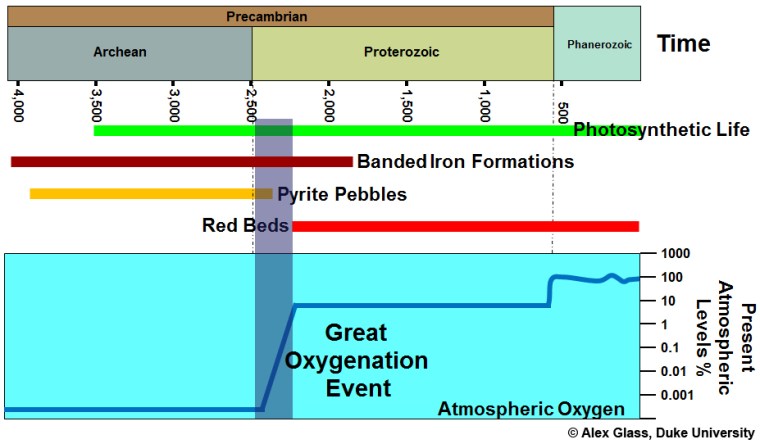
A far more plausible explanation for the active gulley formation is that loose fine sediment can flow in the manner of a liquid, as it does in sand dunes on Earth (see: First signs of liquid water on Mars? June 2000). Yet as remotely sensed image coverage expanded and its resolution improved (currently about 50 cm) masses of evidence for drainage networks, signs of catastrophic floods and even glaciers (The glaciers of Mars, July 2003) emerged. Huge areas of the planet bore witness to a period in its past history – 4.1 to 3.8 billion years (Ga) ago – when it was a warm and wet planet. It has even been suggested that the flat, low-elevation northern hemisphere was the bed of a former ocean, covering about a third of Mars to a depth of about a kilometre. Now the planet has a hyperarid surface and a very thin atmosphere dominated by CO2, a little nitrogen and argon but almost no water vapour (~0.03%). Its poles are covered by ice caps whose extents fluctuate seasonally. They each have a core of permanent water ice, and seasonally expand and contract due to formation and sublimation of dry ice made of solid CO2. So what happened to Mars’s once abundant water?
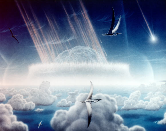
One long-held theory is that water and most of Mars’s original atmosphere escaped to space. A suggested mechanism is the photo-dissociation of water to hydrogen and oxygen. Mars’s gravity cannot prevent hydrogen escape, which would leave an excess of atmospheric oxygen. One thing in abundance on the Martian surface is oxygen combined in iron oxides (Fe2O3); hence its red coloration. This hematite may have formed during chemical weathering of surface rocks and sediments during the wet phase, which released Fe2+ ions that were immediately oxidised by the hyper-oxygenated atmosphere that resulted from photo-dissociation. But there is another plausible explanation …

The lake-bed sediments of Gale Crater on Mars from NASA’s Curiosity rover (credit: NASA/JPL, California Institute of Technology)

The much publicised successful landing of NASA’s Perseverance rover on 18 February 2021 was aimed at the small Jezero Crater, near the Martian equator. This contains an indisputable delta of a large drainage system that must once have filled the crater with a circular lake; a good place to seek out signs of early life, for which Perseverance is impressively equipped. Shortly afterwards there appeared a Research Article in Science (Scheller, E.L. et al. 2021. Long-term drying of Mars by sequestration of ocean-scale volumes of water in the crust. Science, Online research article eabc7717; DOI: 10.1126/science.abc7717) that examines the fate of the planet’s water. The authors estimate that by 3.0 Ga Mars’s surface had reached its current dry state. They model three processes – supply of water by volcanic degassing and its loss by atmospheric escape and chemical weathering of the Martian surface. The modelling was constrained by the ratio of deuterium (2H) to hydrogen inferred from meteorites believed to come from Mars and estimates by orbiting spacecraft of the current escape of hydrogen from the atmosphere. The latter is too slow to explain the huge loss of water between 4 and 3 Ga and subsequently. Addition of water from Mars’s mantle by volcanoes, even from the gigantic Olympus Mons, was far slower than on Earth because continuous plate tectonics was never achieved on Mars. Chemical weathering of the surface during Mars’s warm-wet phase formed abundant hydrated minerals as well as the hematite that gives the planet its characteristic hue. Water transport before 3 Ga moved clays and hydroxides etc to sedimentary basins, where they have remained undisturbed. On Earth, tectonics recycles sediments and their content of hydrated minerals into the mantle, eventually to regurgitate their water content through volcanism. On Mars, weathering and deposition has irreversibly locked-up between 30 and 99% of Mars’s original endowment of water in its ancient sedimentary crust.

That seems to be a ‘bit of a downer’ for ambitious prospects of terraforming Mars and making it a human escape destination. There are, however, some locations where water may be available in sufficient quantities to support some kind of permanent presence of small colonies, in the form of buried layers of ice, similar to permafrost (see: Ice cliffs on Mars, January 2018)

See also:  Carr, M.H. 2012. The fluvial history of Mars. Philosophical Transaction of the Royal Society (A), v. 370, p. 2193-2215; DOI: 10.1098/rsta.2011.0500.

News from the Chicxulub drilling project

Artist’s impression of an asteroid slamming into the shallow sea off the present Yucatán Peninsula about 65 Ma ago (Credit: Donald E. Davis of NASA)

Aimed at resolving the impact versus volcanism debate about the causes of the K-Pg mass extinction, the International Ocean Discovery Program (IODP) and International Continental Scientific Drilling Program (ICDP) began drilling into the focus of the Chicxulub impact structure off the Yucatán Peninsula, Mexico in 2016. The project recovered 830 m of rock core, of which  about 140 cm contained the boundary between tsunami deposits and the post-impact marine limestones of Danian Age (basal Palaeogene); as close as one can get to the moment when the asteroid hit the sea floor. That an impact close to the start of the Danian had taken place was first discovered from abnormally high concentrations of the platinum-group metal iridium (Ir), shocked mineral grains and glass spherules, among other anomalous materials, in 350 marine and terrestrial sections across the globe. If the Chicxulub crater contained similar features to these ‘smoking guns’ then the link might seem to be done and dusted. A report on the crucial few centimetres from the Chicxulub drill core shows this to be the case (Goderis, S. and 32 others 2021. Globally distributed iridium layer preserved within the Chicxulub impact structure. Science Advances, v. 9, article eabe3647; DOI: 10.1126/sciadv.abe3647).

Yet the boundary layer at Chicxulub could not have been emplaced at the instant of impact. The gigantic power involved would have flung debris outwards, including seawater as well as the rocks that were once at considerable depth below the seabed. Much in the manner of a stone falling into a pond molten crust would have rebounded from the initial strike to form an axial peak and a ringed basin. Likewise huge tsunamis would have rolled away from the impact, then to return and fill the new basin, perhaps several times. Some of the ejected debris would have reached low orbit in the form of pulverised rock and asteroid to remain there for a while before completely falling back to Earth. The core includes about 130 m of once partly molten debris (suevite) above more-or-less intact granitic basement. Only the top 3.5 m show signs of having been deposited in water; fine-grained, well-sorted and laminated suevite containing clasts of once molten material and even late-Cretaceous foraminifera tests, formed probably by the refilling of the impact basin during the backflow of tusunamis. A mere 3 cm of silt and clay just below marine limestones has yielded the characteristic high Ir and nickel concentrations. This Ir-rich layer also contains the earliest Palaeocene foraminifera.

Grains in the Ir-rich layer were the last to settle, the main question being ‘How long after the impact took place did that happen?’ Being very fine they are estimated to have fallen-out from suspension and circulation in the atmosphere over a period of up to a few decades. Coarser material below them would have taken no longer than a few weeks to years. Yet these estimates are based mainly on Stokes’ law governing particles of different sizes falling through a viscous fluid. Taking an empirical view based on actual rates of clay sedimentation in the ocean (~5 mm per thousand years) the Ir-rich layer may have been deposited over 6000 years. That is hardly the ‘instant of the impact’. But the timing does say something interesting about the return of life to the seas; in geological terms it was swift, if the forams are anything to go by. Since the tsunamis swept onto and drained the surrounding land masses a great deal of nutrient would have ended up in the sea awaiting organisms at the bottom of the food chain. Biomarker chemicals and trace fossils in the Ir-rich layer suggest  thriving bacterial communities, with forams, crustacea and larval fish.

The authors conclude ‘The clear association of the Ir anomaly within the Chicxulub impact structure and the recorded biotic response confirms the direct relationship between the impact event and the K-Pg mass extinction’. Whether that is accepted by those geoscientists with their eyes on the Deccan Trap hypothesis is not so certain …

The oldest known impact structure (?)

That large, rocky bodies in the Solar System were heavily bombarded by asteroidal debris at the end of the Hadean Eon (between 4.1 to 3.8 billion years ago) is apparent from the ancient cratering records that they still preserve and their matching with dating of impact-melt rocks on the Moon. Being a geologically dynamic planet, the Earth preserves no tangible, indisputable evidence for this Late Heavy Bombardment (LHB), and until quite recently could only be inferred to have been battered in this way. That it actually did happen emerged from a study of tungsten isotopes in early Archaean gneisses from Labrador, Canada (see: Tungsten and Archaean heavy bombardment, August 2002; and Did mantle chemistry change after the late heavy bombardment? September 2009). Because large impacts deliver such vast amounts of energy in little more than a second (see: Graveyard for asteroids and comets, Chapter 10 in Stepping Stones) they have powerful consequences for the Earth System, as witness the Chicxulub impact off the Yucatán Peninsula of Mexico that resulted in a mass extinction at the end of the Cretaceous Period. That seemingly unique coincidence of a large impact with devastation of Earth’s ecosystems seems likely to have resulted from the geology beneath the impact; dominated by thick evaporite beds of calcium sulfate whose extreme heating would have released vast amounts of SO2 to the atmosphere. Its fall-out as acid rain would have dramatically affected marine organisms with carbonate shells. Impacts on land would tend to expend most of their energy throughout the lithosphere, resulting in partial melting of the crust or the upper mantle in the case of the largest such events.

The further back in time, the greater the difficulty in recognising visible signs of impacts because of erosion or later deformation of the lithosphere. With a single, possible exception, every known terrestrial crater or structure that may plausibly be explained by impact is younger than 2.5 billion years; i.e. they are post-Archaean. Yet rocky bodies in the Solar System reveal that after the LHB the frequency and magnitude of impacts steadily decreased from high levels during the Archaean; there must have been impacts on Earth during that Eon and some may have been extremely large. In the least deformed Archaean sedimentary sequences there is indirect evidence that they did occur, in the form of spherules that represent droplets of silicate melts (see: Evidence builds for major impacts in Early Archaean; August 2002, and Impacts in the early Archaean; April 2014), some of which contain unearthly proportions of different chromium isotopes (see: Chromium isotopes and Archaean impacts; March 2003). As regards the search for very ancient impacts, rocks of Archaean age form a very small proportion of the Earth’s continental surface, the bulk having been buried by younger rocks. Of those that we can examine most have been subject to immense deformation, often repeatedly during later times.

The Archaean geology of part of the Akia Terrane (Manitsoq area) in West Greenland. The suggested impact structure is centred on the Finnefjeld Gneiss (V symbols) surrounded by highly deformed ultramafic to mafic igneous rocks. (Credit: Jochen Kolb, Karlsruhe Institute of Technology, Germany)

There is, however, one possibly surviving impact structure from Archaean times, and oddly it became suspected in one of the most structurally complex areas on Earth; the Akia Terrane of West Greenland. Aeromagnetic surveys hint at two concentric, circular anomalies centred on a 3.0 billion years-old zone of grey gneisses (see figure) defining a cryptic structure. It is is surrounded by hugely deformed bodies of ultramafic and mafic rocks (black) and nickel mineralisation (red). In 2012 the whole complex was suggested to be a relic of a major impact of that age, the ultramafic-mafic bodied being ascribed to high degrees of impact-induced melting of the underlying mantle. The original proposers backed up their suggestion with several associated geological observations, the most crucial being supposed evidence for shock-deformation of mineral grains and anomalous concentrations of platinum-group metals (PGM).

A multinational team of geoscientists have subjected the area to detailed field surveys, radiometric dating, oxygen-isotope analysis and electron microscopy of mineral grains to test this hypothesis (Yakymchuck, C. and 8 others 2020. Stirred not shaken; critical evaluation of a proposed Archean meteorite impact in West Greenland. Earth and Planetary Science Letters, v. 557, article 116730 (advance online publication); DOI: 10.1016/j.epsl.2020.116730). Tectonic fabrics in the mafic and ultramafic rocks are clearly older than the 3.0 Ga gneisses at the centre of the structure. Electron microscopy of ~5500 zircon grains show not a single example of parallel twinning associated with intense shock. Oxygen isotopes in 30 zircon grains fail to confirm the original proposers’ claims that the whole area has undergone hydrothermal metamorphism as a result of an impact. All that remains of the original suggestion are the nickel deposits that do contain high PGM concentrations; not an uncommon feature of Ni mineralisation associated with mafic-ultramafic intrusions, indeed much of the world’s supply of platinoid metals is mined from such bodies. Even if there had been an impact in the area, three phases of later ductile deformation that account for the bizarre shapes of these igneous bodies would render it impossible to detect convincingly.

The new study convincingly refutes the original impact proposal. The title of Yakymchuck et al.’s paper aptly uses Ian Fleming’s recipe for James Bond’s tipple of choice; multiple deformation of the deep crust does indeed stir it by ductile processes, while an impact is definitely just a big shake. For the southern part of the complex (Toqqusap Nunaa), tectonic stirring was amply demonstrated in 1957 by Asger Berthelsen of the Greenland Geological Survey (Berthelsen, A. 1957. The structural evolution of an ultra- and polymetamorphic gneiss-complex, West Greenland. Geologische Rundschau, v. 46, p. 173-185; DOI: 10.1007/BF01802892). Coming across his paper in the early 60s I was astonished by the complexity that Berthelsen had discovered, which convinced me to emulate his work on the Lewisian Gneiss Complex of the Inner Hebrides, Scotland. I was unable to match his efforts. The Akia Terrane has probably the most complicated geology anywhere on our planet; the original proposers of an impact there should have known better …

Origin of life: some news

For self-replicating cells to form there are two essential precursors: water and simple compounds based on the elements carbon, hydrogen, oxygen and nitrogen (CHON). Hydrogen is not a problem, being by far the most abundant element in the universe. Carbon, oxygen and nitrogen form in the cores of stars through nuclear fusion of hydrogen and helium. These elemental building blocks need to be delivered through supernova explosions, ultimately to where water can exist in liquid form to undergo reactions that culminate in living cells. That is only possible on solid bodies that lie at just the right distance from a star to support average surface temperatures that are between the freezing and boiling points of water. Most important is that such a planet in the ‘Goldilocks Zone’ has sufficient mass for its gravity to retain water. Surface water evaporates to some extent to contribute vapour to the atmosphere. Exposed to ultraviolet radiation H2O vapour dissociates into molecular hydrogen and water, which can be lost to space if a planet’s escape velocity is less than the thermal vibration of such gas molecules. Such photo-dissociation and diffusion into outer space may have caused Mars to lose more hydrogen in this way than oxygen, to leave its surface dry but rich in reddish iron oxides.

Despite liquid water being essential for the origin of planetary life it is a mixed blessing for key molecules that support biology. This ‘water paradox’ stems from water molecules attacking and breaking the chemical connections that string together the complex chains of proteins and nucleic acids (RNA and DNA). Living cells resolve the paradox by limiting the circulation of liquid water within them by being largely filled with a gel that holds the key molecules together, rather than being bags of water as has been commonly imagined. That notion stemmed from the idea of a ‘primordial soup’, popularised by Darwin and his early followers, which is now preserved in cells’ cytoplasm. That is now known to be wrong and, in any case, the chemistry simply would not work, either in a ‘warm, little pond’ or close to a deep sea hydrothermal vent, because the molecular chains would be broken as soon as they formed. Modern evolutionary biochemists suggest that much of the chemistry leading to living cells must have taken place in environments that were sometimes dry and sometimes wet; ephemeral puddles on land. Science journalist Michael Marshall has just published an easily read, open-source essay on this vexing yet vital issue in Nature (Marshall, M. 2020. The Water Paradox and the Origins of Life. Nature, v. 588, p. 210-213; DOI: 10.1038/d41586-020-03461-4). If you are interested, click on the link to read Marshall’s account of current origins-of-life research into the role of endlessly repeated wet-dry cycles on the early Earth’s surface. Fascinating reading as the experiments take the matter far beyond the spontaneous formation of the amino acid glycine found by Stanley Miller when he passed sparks through methane, ammonia and hydrogen in his famous 1953 experiment at the University of Chicago. Marshall was spurred to write in advance of NASA’s Perseverance Mission landing on Mars in February 2021. The Perseverance rover aims to test the new hypotheses in a series of lake sediments that appear to have been deposited by wet-dry cycles  in a small Martian impact crater (Jezero Crater) early in the planet’s history when surface water was present.

Crystals of hexamethylenetetramine (Credit: r/chemistry, Reddit)

That CHON and simple compounds made from them are aplenty in interstellar gas and dust clouds has been known since the development of means of analysing the light spectra from them. The organic chemistry of carbonaceous meteorites is also well known; they even smell of hydrocarbons. Accretion of these primitive materials during planet formation is fine as far as providing feedstock for life-forming processes on physically suitable planets. But how did CHON get from giant molecular clouds into such planetesimals. An odd-sounding organic compound – hexamethylenetetramine ((CH2)6N4), or HMT – formed industrially by combining formaldehyde (CH2O) and ammonia (NH3) – was initially synthesised in the late 19th century as an antiseptic to tackle UTIs and is now used as a solid fuel for lightweight camping stoves, as well as much else besides. HMT has a potentially interesting role to play in the origin of life.  Experiments aimed at investigating what happens when starlight and thermal radiation pervade interstellar gas clouds to interact with simple CHON molecules, such as ammonia, formaldehyde, methanol and water, yielded up to 60% by mass of HMT.

The structure of HMT is a sort of cage, so that crystals form large fluffy aggregates, instead of the gases from which it can be formed in deep space. Together with interstellar silicate dusts, such sail-like structures could accrete into planetesimals in nebular star nurseries under the influence of  gravity and light pressure. Geochemists from several Japanese institutions and NASA have, for the first time, found HMT in three carbonaceous chondrites, albeit at very low concentrations – parts per billion (Y. Oba et al. 2020. Extraterrestrial hexamethylenetetramine in meteorites — a precursor of prebiotic chemistry in the inner Solar SystemNature Communications, v. 11, article 6243; DOI: 10.1038/s41467-020-20038-x). Once concentrated in planetesimals – the parents of meteorites when they are smashed by collisions – HMT can perform the useful chemical ‘trick’ of breaking down once again to very simple CHON compounds when warmed. At close quarters such organic precursors can engage in polymerising reactions whose end products could be the far more complex sugars and amino acid chains that are the characteristic CHON compounds of carbonaceous chondrites. Yasuhiro Oba and colleagues may have found the missing link between interstellar space, planet formation and the synthesis of life through the mechanisms that resolve the ‘water paradox’ outlined by Michael Marshall.

See also: Scientists Find Precursor of Prebiotic Chemistry in Three Meteorites (Sci-news, 8 December 2020.)


Supernova at the start of the Pleistocene

This brief note takes up a thread begun in Can a supernova affect the Earth System? (August 2020). In February 2020 the brightness of Betelgeuse – the prominent red star at the top-left of the constellation Orion – dropped in a dramatic fashion. This led to media speculation that it was about to ‘go supernova’, but with the rise of COVID-19 beginning then, that seemed the least of our worries. In fact, astronomers already knew that the red star had dimmed many times before, on a roughly 6.4-year time scale. Betelgeuse is a variable star and by March 2020 it brightened once again: shock-horror over; back to the latter-day plague.

When stars more than ten-times the mass of the Sun run out of fuel for the nuclear fusion energy that keeps them ‘inflated’ they collapse. The vast amount of gravitational potential energy released by the collapse triggers a supernova and is sufficient to form all manner of exotic heavy isotopes by nucleosynthesis. Such an event radiates highly energetic and damaging gamma radiation, and flings off dust charged with a soup of exotic isotopes at very high speeds. The energy released could sum to the entire amount of light that our Sun has shone since it formed 4.6 billion years ago. If close enough, the dual ‘blast’ could have severe effects on Earth, and has been suggested to have caused the mass extinction at the end of the Ordovician Period.

Betelgeuse is about 700 light years away, massive enough to become a future supernova and its rapid consumption of nuclear fuel – it is only about 10 million years old – suggests it will do so within the next hundred thousand years. Nobody knows how close such an event needs to be to wreak havoc on the Earth system, so it is as well to check if there is evidence for such linked perturbations in the geological record. The isotope 60Fe occurs in manganese-rich crusts and nodules on the floor of the Pacific Ocean and also in some rocks from the Moon. It is radioactive with a half-life of about 2.6 million years, so it soon decays away and cannot have been a part of Earth’s original geochemistry or that of the Moon. Its presence may suggest accretion of debris from supernovas in the geologically recent past: possibly 20 in the last 10 Ma but with apparently no obvious extinctions. Yet that isotope of iron may also be produced by less-spectacular stellar processes, so may not be a useful guide.

There is, however, another short-lived radioactive isotope, of manganese (53Mn), which can only form under supernova conditions. It has been found in ocean-floor manganese-rich crusts by a German-Argentinian team of physicists  (Korschinek, G. et al. 2020. Supernova-produced 53Mn on Earth. Physical Review Letters, v. 125, article 031101; DOI: 10.1103/PhysRevLett.125.031101). They dated the crusts using another short-lived cosmogenic isotope produced when cosmic rays transform the atomic nuclei of oxygen and nitrogen to 10Be that ended up in the manganese-rich crusts along with any supernova-produced  53Mn and 60Fe. These were detected in parts of four crusts widely separated on the Pacific Ocean floor. The relative proportions of the two isotopes matched that predicted for nucleosynthesis in supernovas, so the team considers their joint presence to be a ‘smoking gun’ for such an event.

The 10Be in the supernova-affected parts of the crusts yielded an age of 2.58 ± 0.43 million years, which marks the start of the Pleistocene Epoch, the onset of glacial cycles in the Northern Hemisphere and the time of the earliest known members of the genus Homo. A remarkable coincidence? Possibly. Yet cosmic rays, many of which come from supernova relics, have been cited as a significant source of nucleation sites for cloud condensation. Clouds increase the planet’s reflectivity and thus act to to cool it. This has been a contentious issue in the debate about modern climate change, some refuting their significance on the basis of a lack of correlation between cloud-cover data and changes in the flux of cosmic rays over the last century. Yet, over the five millennia of recorded history there have been no records of supernovas with a magnitude that would suggest they were able to bathe the night sky in light akin to that of daytime. That may be the signature of one capable of affecting the Earth system. Thousands that warrant being dubbed a ‘very large new star’are recorded, but none that ‘turned night into day’. The hypothesis seems to have ‘legs’, but so too do others, such as the slow influence on oceanic circulation of the formation of the Isthmus of Panama and other parochial mechanisms of changing the transfer of energy around our planet

See also: Stellar explosion in Earth’s proximity, eons ago. (Science Daily; 30 September 2020.)

Photosynthesis, arsenic and a window on the Archaean world

At the very base of the biological pyramid life is far simpler than that which we can see.  It takes the form of single cells that lack a nucleus and propagate only by cloning: the prokaryotes as opposed to eukaryote life such as ourselves. It is almost certain that the first viable life on Earth was prokaryotic, though which of its two fundamental divisions – Archaea or Bacteria – came first is still debated. At present, most prokaryotes metabolise other organisms’ waste or dead remains: they are heterotrophs (from the Greek for ‘other nutrition’). But there are others that are primary producers getting their nutrition by themselves, exploiting the inorganic world in a variety of ways: the autotrophs. Biogeochemical evidence from the earliest sedimentary rocks suggests that, in the Archaean prokaryotic autotrophs were dominant, mainly exploiting chemical reactions to gain energy necessary for building carbohydrates. Some reduced sulfate ions to those of sulphide, others combined hydrogen with carbon dioxide to generate methane as a by-product. Sunlight being an abundant energy resource in near-surface water, a whole range of prokaryotes exploit its potential through photosynthesis. Under reducing conditions some photosynthesisers convert sulfur to sulfuric acid , yet others combine photosynthesis with chemo-autotrophy. Dissolved material capable of donating electrons – i.e. reducing agents – are exploited in photosynthesis: hydrogen, ferrous iron (Fe2+), reduced sulfur, nitrite, or some organic molecules. Without one group, which uses photosynthesis to convert CO2 and water to carbohydrates and oxygen, eukaryotes would never have arisen, for they depend on free oxygen. A transformation 2400 Ma ago marked a point in Earth history when oxygen first entered the atmosphere and shallow water (see: Massive event in the Precambrian carbon cycle; January, 2012), known as Great Oxygenation Event (GOE). It has been shown that the most likely sources of that excess oxygen were extensive bacterial mats in shallow water made of photosynthesising blue-green bacteria that produced the distinctive carbonate structures known as stromatolites. These had formed in Archaean sedimentary basins for 1.9 billion years. It has been generally assumed that blue-green bacteria had formed them too, before the oxygen that they produced overcame the reducing conditions that had generally prevailed before the GOE. But that may not have been the case …

Microbial mats made by purple sulfur bacteria in highly toxic spring water flowing into a salt-lake in northern Chile. (credit: Visscher et al. 2020; Fig 1c)

Prokaryotes are a versatile group and new types keep turning up as researchers explore all kinds of strange and extreme environments, for instance: hot springs; groundwater from kilometres below the surface and highly toxic waters. A recent surprise arose from the study of anoxic springs laden with dissolved salts, sulfide ions and arsenic that feed parts of hypersaline lakes in northern Chile (Visscher, P.T. and 14 others 2020. Modern arsenotrophic microbial mats provide an analogue for life in the anoxic ArcheanCommunications Earth & Environment, v. 1, article 24; DOI: 10.1038/s43247-020-00025-2). This is a decidedly extreme environment for life, as we know it, made more challenging by its high altitude exposure to high UV radiation. The springs’ beds are covered with bright-purple microbial mats. Interestingly the water’s arsenic concentration varies from high in winter to low in summer, suggesting that some process removes it, along with sulfur, according to light levels: almost certainly the growth and dormancy of mat-forming bacteria. Arsenic is an electron donor capable of participating in photosynthesis that doesn’t produce oxygen. The microbial mats do produce no oxygen whatever – uniquely for the modern Earth – but they do form carbonate crusts that look like stromatolites. The mats contain purple sulfur bacteria (PSBs) that are anaerobic photosynthesisers, which use sulfur, hydrogen and Fe2+ as electron donors. The seasonal changes in arsenic concentration match similar shifts in sulfur, suggesting that arsenic is also being used by the PSBs. Indeed they can, as the aio gene, which encodes for such an eventuality, is present in the genome of PSBs.

Pieter Visscher and his multinational co-authors argue for prokaryotes similar to modern PSBs having played a role in creating the stromatolites found in Archaean sedimentary rocks. Oxygen-poor, the Archaean atmosphere would have contained no ozone so that high-energy UV would have bathed the Earth’s surface and its oceans to a considerable depth. Moreover, arsenic is today removed from most surface water by adsorption on iron hydroxides, a product of modern oxidising conditions (see: Arsenic hazard on a global scale; May 2020): it would have been more abundant before the GOE. So the Atacama springs may be an appropriate micro-analogue for Archaean conditions, a hypothesis that the authors address with reference to the geochemistry of sedimentary rocks in Western Australia deposited in a late-Archaean evaporating lake. Stromatolites in the Tumbiana Formation show, according to the authors, definite evidence for sulfur and arsenic cycling similar to that in that Atacama springs. They also suggest that photosynthesising blue-green bacteria (cyanobacteria) may not have viable under such Archaean conditions while microbes with similar metabolism to PSBs probably were. The eventual appearance and rise of oxygen once cyanobacteria did evolve, perhaps in the late-Archaean, left PSBs and most other anaerobic microbes, to which oxygen spells death, as a minority faction trapped in what are became ‘extreme’ environments when long before they ‘ruled the roost’. It raises the question, ‘What if cyanobacteria had not evolved?’. A trite answer would be, ‘I would not be writing this and nor would you be reading it!’. But it is a question that can be properly applied to the issue of alien life beyond Earth, perhaps on Mars. Currently, attempts are being made to detect oxygen in the atmospheres of exoplanets orbiting other stars, as a ‘sure sign’ that life evolved and thrived there too. That may be a fruitless venture, because life happily thrived during Earth’s Archaean Eon until its closing episodes without producing a whiff of oxygen.

See also: Living in an anoxic world: Microbes using arsenic are a link to early life. (Science Daily, 22 September 2020)

Centenary of the Milanković Theory

A letter in the latest issue of Nature Geoscience (Cvijanovic, I. et al. 2020. One hundred years of Milanković cycles, v. Nature Geoscience , v.13p. 524–525; DOI: 10.1038/s41561-020-0621-2) reveals the background to Milutin Milanković’s celebrated work on the astronomical  driver of climate cyclicity. Although a citizen of Serbia, he had been born at Dalj, a Serbian enclave, in what was Austro-Hungary. Just before the outbreak of World War I in 2014, he returned to his native village to honeymoon with his new bride. The assassination (29 June 2014) in Sarajevo of Archduke Franz Ferdinand by Bosnian-Serb nationalist Gavrilo Princip prompted Austro-Hungarian authorities to imprison Serbian nationals. Milanković was interned in a PoW camp. Fortunately, his wife and and a former Hungarian colleague managed to negotiate his release, on condition that he served his captivity, with a right to work but under police surveillance, in Budapest. It was under these testing conditions that he wrote his seminal Mathematical Theory of Heat Phenomena Produced by Solar Radiation; finished in 1917 but remaining unpublished until 1920 because of a shortage of paper during the war.

Curiously, Milanković was a graduate in civil engineering — parallels here with Alfred Wegener of Pangaea fame, who was a meteorologist — and practised in Austria. Appointed to a professorship in Belgrade in 1909, he had to choose a field of research. To insulate himself from the rampant scientific competitiveness of that era, he chose a blend of mathematics and astronomy to address climate change. During his period as a political prisoner Milanković became the first to explain how the full set of cyclic variations in Earth’s orbit — eccentricity, obliquity and precession — caused distinct variations in incoming solar radiation at different latitudes and changed on multi-thousand-year timescales. The gist  of what might have lain behind the cyclicity of ice ages had first been proposed by Scottish scientist James Croll almost half a century earlier, but it was Milutin Milanković who, as it were, put the icing on the cake. What is properly known as the Milanković-Croll Theory triumphed in the late 1970s as the equivalent of plate tectonics in palaeoclimatology after Nicholas Shackleton and colleagues teased out the predicted astronomical signals from time series of oxygen isotope variations in marine-sediment cores.

Appropriately, while Milanković’s revoluitionary ideas lacked corroborating geological evidence, one of the first to spring to his support was that other resilient scientific ‘prophet’, Alfred Wegener. Neither of them lived to witness their vindication.

Kicking-off planetary Snowball conditions

Untitled-1
Artist’s impression of the glacial maximum of a Snowball Earth event (Source: NASA)

Twice in the Cryogenian Period of the Neoproterozoic, glacial- and sea ice extended from both poles to the Equator, giving ‘Snowball Earth’ conditions. Notable glacial climates in the Phanerozoic – Ordovician, Carboniferous-Permian and Pleistocene – were long-lived but restricted to areas around the poles, so do not qualify as Snowball Earth conditions. It is possible, but less certain, that Snowball Earth conditions also prevailed during the Palaeoproterozoic at around 2.4 to 2.1 billion years ago. This earlier episode roughly coincided with the ‘Great Oxidation Event’, and one explanation for it is that the rise of atmospheric oxygen removed methane, a more powerful greenhouse gas than carbon dioxide, by oxidizing it to CO2 and water. That may well have been a consequence of the evolution of the cyanobacteria, their photosynthesis releasing oxygen to the atmosphere. The Neoproterozoic ‘big freezes’ are associated with rapid changes in the biosphere, most importantly with the rise of metazoan life in the form of the Ediacaran fauna, the precursor to the explosion in animal diversity during the Cambrian. Indeed all major global coolings, restricted as well as global, find echoes in the course of biological evolution. Another interwoven factor is the rock cycle, particularly volcanism and the varying pace of chemical weathering. The first releases CO2 from the mantle, the second helps draw it down from the atmosphere when weak carbonic acid in rainwater rots silicate minerals (see: Can rock weathering halt global warming, July 2020). All such interplays between major and sometimes minor ‘actors’ in the Earth system influence climate and, in turn, climate inevitably affects all the rest. With such complexity it is hardly surprising that there is a plethora of theories about past climate shifts.

As well as a link with fluctuations in the greenhouse effect, climate is influenced by changes in the amount of solar heating, for which there are yet more options to consider. For instance, the increase in Earth’s albedo (reflectivity) that results from ice cover, may lead through a feedback effect to runaway cooling, particularly once ice extends beyond the poorly illuminated poles. Volcanic dust and sulfate aerosols in the stratosphere also increase albedo and the tendency to cooling, as would interplanetary dust. More complexity to befuddle would-be modellers of ancient climates. Yet it is safe to say that, within the maelstrom of contributory factors, the freeze-overs of Snowball conditions must have resulted from our planet passing through some kind of threshold in the Earth System. Two theoretical scientists from the Department of Earth, Atmospheric, and Planetary Sciences at the Massachusetts Institute of Technology have attempted to cut through the log-jam by modelling the dynamics of the interplay between the ice-albedo feedback and the carbon-silicate cycle of weathering (Arnscheidt, C.W. & Rothman, D.H. 2020. Routes to global glaciation. Proceedings of the Royal Society A, v. 476, article 0303 online; DOI: 10.1098/rspa.2020.0303). Their mathematical approach involves two relatively simple, if long-winded, equations based on parameters that express solar heating, albedo, surface temperature and pressure, and the rate of volcanic outgassing of CO2; a simplification that sets biological processes to one side.

Unlike previous models, theirs can simulate varying rates, particularly of changes in solar energy input. The key conclusion of the paper is that if solar heating decreases faster than a threshold rate the more a planet’s surface water is likely to freeze from pole to pole. The authors suggest that a Snowball Earth event would result from a 2% fall in received solar radiation over about ten thousand years: pretty quick in a geological sense. Such a trigger might stem from a volcanic ‘winter’ scenario, an increase in clouds seeded by spores of primitive marine algae or other factors. The real ‘tipping point’ would probably be the high albedo of ice. There is a warning in this for the present, when a variety of means of decreasing solar input have been proposed as a ‘solution’ to global warming.

Because the Earth orbits the Sun in the ‘Goldilocks Zone’ and is volcanically active even global glaciation would be temporary, albeit of the order of millions of years. The cold would have shut down weathering so that volcanic CO2 could slowly build up in the atmosphere: the greenhouse effect would rescue the planet. Further from the Sun, a planet would not have that escape route, regardless of its atmospheric concentration of greenhouse gases: a neat lead-in to another recent paper about the ancient climate of Mars (Grau Galofre, A. et al. 2020. Valley formation on early Mars by subglacial and fluvial erosion. Nature Geoscience, early online article; DOI: 10.1038/s41561-020-0618-x)

A Martian channel system: note later cratering (credit: European Space Agency)

There is a lot of evidence from both high-resolution orbital images of the Martian surface and surface ‘rovers’ that surface water was abundant over a long period in Mars’s early history. The most convincing are networks of channels, mainly in the southern hemisphere highlands. They are not the vast channelled scablands, such as those associated with Valles Marineris, which probably resulted from stupendous outburst floods connected to catastrophic melting of subsurface ice by some means. There are hundreds of channel networks, that resemble counterparts on Earth. Since rainfall and melting of ice and snow have carved most terrestrial channel networks, traditionally those on Mars have been attributed to similar processes during an early warm and wet phase. The warm-early Mars hypothesis extends even to interpreting the smooth low-lying plains of its northern hemisphere – about a third of Mars’s surface area – as the site of an ocean in those ancient times. Of course, a big question is, ‘Where did all that water go?’ Another relates to the fact that the early Sun emitted considerably less radiation 4.5 billion years ago than it does now: a warm-wet early Mars is counterintuitive.

Anna Grau Galofre of the University of British Columbia and co-authors found that many of the networks on Mars clearly differ in morphology from one another, even in small areas of its surface. Drainage networks on Earth conform to far fewer morphological types. By comparing the variability on Mars with channel-network shapes on Earth, the authors found a close match for many with those that formed beneath the ice sheet that covered high latitudes of North America during the last glaciation. Some match drainage patterns typical of surface-water erosion, but both types are present in low Martian latitudes: a suggestion of ‘Snowball Mars’ conditions? The authors reached their conclusions by analysing six mathematical measures that describe channel morphology for over ten thousand individual valley systems. Previous analyses of individual systems discovered on high-resolution images have qualitative comparisons with terrestrial geomorphology

See also: Chu, J. 2020. “Snowball Earths” May Have Been Triggered by a Plunge in Incoming Sunlight – “Be Wary of Speed” (SciTech Daily 29 July 2020); Early Mars was covered in ice sheets, not flowing rivers, researchers say (Science Daily, 3 August 2020)

Earliest plate tectonics tied down?

Papers that ponder the question of when plate tectonics first powered the engine of internal geological processes are sure to get read: tectonics lies at the heart of Earth science. Opinion has swung back and forth from ‘sometime in the Proterozoic’ to ‘since the very birth of the Earth’, which is no surprise. There are simply no rocks that formed during the Hadean Eon of any greater extent than 20 km2. Those occur in the 4.2 billion year (Ga) old Nuvvuagittuq greenstone belt on Hudson Bay, which have been grossly mangled by later events. But there are grains of the sturdy mineral zircon ZrSiO4)  that occur in much younger sedimentary rocks, famously from the Jack Hills of Western Australia, whose ages range back to 4.4 Ga, based on uranium-lead radiometric dating. You can buy zircons from Jack Hills on eBay as a result of a cottage industry that sprang up following news of their great antiquity: that is, if you do a lot of mineral separation from the dust and rock chips that are on offer, and they are very small. Given a laser-fuelled SHRIMP mass spectrometer and a lot of other preparation kit, you could date them. Having gone to that expense, you might as well analyse them chemically using laser ablation inductively coupled plasma mass spectrometry (LA-ICP-MS) to check out their trace-element contents. Geochemist Simon Turner of Macquarie University in Sydney, Australia, and colleagues from Curtin University in Western Australia and Geowissenschaftliches Zentrum Göttingen in Germany, have done all this for 32 newly extracted Jack Hills zircons, whose ages range from 4.3 to 3.3 Ga (Turner, S. et al. 2020. An andesitic source for Jack Hills zircon supports onset of plate tectonics in the HadeanNature Communications, v. 11, article 1241; DOI: 10.1038/s41467-020-14857-1). Then they applied sophisticated geochemical modelling to tease out what kinds of Hadean rock once hosted these grains that were eventually eroded out and transported to come to rest in a much younger sedimentary rock.

Artist’s impression of the old-style hellish Hadean (Credit : Dan Durday, Southwest Research Institute)

Zircons only form duuring the crystallisation of igneous magmas, at around 700°C, the original magma having formed under somewhat hotter conditions – up to 1200°C for mafic compositions. In the course of their crystallising, minerals take in not only the elements of which they are mainly composed, zirconium, silicon and oxygen in the case of zircon , but many other elements that the magma contains in low concentrations. The relative proportions of these trace elements that are partitioned from the magma into the growing mineral grains are more or less constant and unique to that mineral, depending on the particular composition of the magma itself. Using the proportions of these trace elements in the mineral gives a clue to the original bulk composition of the parent magma. The Jack Hills zircons  mainly  reflect an origin in magmas of andesitic composition, intermediate in composition between high-silica granites and basalts that have lower silica contents. Andesitic magmas only form today by partial melting of more mafic rocks under the influence of water-rich fluid driven upwards from subducting oceanic lithosphere. The proportions of trace elements in the zircons could only have formed in this way, according to the authors.

Interestingly, the 4.2 Ga Nuvvuagittuq greenstone belt contains metamorphosed mafic andesites, though any zircons in them have yet to be analysed in the manner used by Turner et al., although they were used to date those late-Hadean rocks. The deep post-Archaean continental crust, broadly speaking, has an andesitic composition, strongly suggesting its generation above subduction zones. Yet that portion of Archaean age is not andesitic on average, but a mixture of three geochemically different rocks. It is referred to as TTG crust from those three rock types (trondhjemite, tonalite and granodiorite). That TTG nature of the most ancient continental crust has encouraged most geochemists to reject the idea of magmatic activity controlled by plate tectonics during the Archaean and, by extension, during the preceding Hadean. What is truly remarkable is that if mafic andesites – such as those implied by the Jack Hills zircons and found in the Nuvvuagittuq greenstone belt – partially melted under high pressures that formed garnet in them, they would have yielded magmas of TTG composition. This, it seems, puts plate tectonics in the frame for the whole of Earth’s evolution since it stabilised several million years after the catastrophic collision that flung off the Moon and completely melted the outer layers of our planet. Up to now, controversy about what kind of planet-wide processes operated then have swung this way and that, often into quite strange scenarios. Turner and colleagues may have opened a new, hopefully more unified, episode of geochemical studies that revisit the early Earth . It could complement the work described in An Early Archaean Waterworld published on Earth-logs earlier in March 2020.

An Early Archaean Waterworld

In Earth-logs you may have come across the uses of oxygen isotopes, mainly in connection with their variations in the fossils of marine organisms and in ice cores. The relative proportion of the ‘heavy’ 18O isotope to the ‘light’ 16O, expressed by δ18O, is a measure of the degree of fractionation between these isotopes under different temperature conditions when water evaporates. What happens is that H216O, in which the lighter isotope is bound up, slightly more easily evaporates thus enriching the remaining liquid water in H218O. As a result the greater the temperature of surface water and the more of evaporates, the higher is its δ18O value. Shells that benthonic (surface-dwelling) organism secrete are made mainly of the mineral calcite (CaCO3). Their formation involves extracting dissolved calcium ions and CO2 plus an extra oxygen from the water itself, as calcite’s formula suggests. So plankton shells fossilised  in ocean-floor sediments carry the δ18O and thus a temperature signal of surface water at the place and time in which they lived. Yet this signal is contaminated with another signal: that of the amount of water evaporated from the ocean surface (with lowered  δ18O) that has ended up falling as snow and then becoming trapped in continental ice sheets. The two can be separated using the δ18O found in shells of bottom-dwelling (benthonic) organisms, because deep ocean water maintains a similar low temperature at all time (about 2°C). Benthonic δ18O is the main guide to the changing volume of continental ice throughout the last 30 million year or so. This ingenious approach, developed about 50 years ago, has become the key to understanding past climate changes as reflected in records of ice volume and ocean surface temperature. Yet these two factors are not the only ones at work on marine oxygen isotopes.

Artistic impression of the Early Archaean Earth dominated by oceans (Credit: Sci-news.com)

When rainwater flows across the land, clays in the soil formed by weathering of crystalline rocks preferentially extract 18O and thus leave their own δ18O mark in ocean water. This has little, if any, effect on the use of δ18O to track past climate change, simply because the extent of the continents hasn’t changed much over the last 2 billion years or so. Likewise, the geological record over that period clearly indicates that rain, wet soil and water flowing across the land have all continued somewhere or other, irrespective of climate. However, one of the thorny issues in Earth science concerns changes of the area of continents in the very long term. They are suspected but difficult to tie down. Benjamin Johnson of the University of Colorado and Boswell Wing of Iowa State University, USA, have closely examined oxygen isotopes in 3.24 billion-year old rocks from a relic of Palaeoarchaean ocean crust from the Pilbara district of Western Australia that shows pervasive evidence of alteration by hot circulating ocean water (Johnson, B.W. & Wing, B.A. 2020. Limited Archaean continental emergence reflected in an early Archaean 18O-enriched ocean. Nature Geoscience, v. 13, p. 243-248; DOI: 10.1038/s41561-020-0538-9). Interestingly, apart from the composition of the lavas, the altered rocks look just the same as much more recent examples of such ophiolites.

The study used many samples taken from the base to the top of the ophiolite along some 20 traverses across its outcrop. Overall the isotopic analyses suggested that the circulating water responsible for the hydrothermal alteration 3.2 Ga ago was much more enriched in 18O than is modern ocean water. The authors’ favoured explanation is that much less continental crust was exposed above sea level during the Palaeoarchaean Era than in later times and so far less clay was around on land. That does not necessarily imply that less continental crust existed at that time compared with the Archaean during the following 700 Ma , merely that the continental ‘freeboard’ was so low that only a few islands emerged above the waves. By the end of the Archaean 2.5 Ga ago the authors estimate that oceanic δ18O had decreased to approximately modern levels. This they attribute to a steady increase in weathering of the emerging continental landmasses and the extraction of 18O into new, clay-rich soils as the continents emerged above sea level. How this scenario of a ‘drowned’ world developed is not discussed. One possibility is that the average depth of the oceans then was considerably less than it was in later times: i.e. sea level stood higher because the volume available to contain ocean water was less. One possible explanation for that and the subsequent change in oxygen isotopes might be a transition during the later Archaean Eon into modern-style plate tectonics. The resulting steep subduction forms deep trench systems able to ‘hold’ more water. Prior to that faster production of oceanic crust resulted in what are now the ocean abyssal plains being buoyed up by warmer young crust that extended beneath them. Today they average around 4000 m deep, thanks to the increased density of cooled crust, and account for a large proportion of the volume of modern ocean basins.