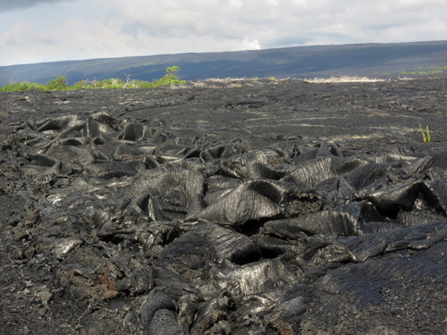
If any technical terms are likely to be remembered by anyone exposed to a bit of geological education, amongst them will be two that are Hawaiian Polynesian words: pahoehoe (‘pa hoy hoy’) and aa (‘a ah’). The first slides around the palate wonderfully while the latter give a sort of worrisome feel as if a large weight is about to land on one’s toes. Aa is lava with a blocky, broken and jagged surface, whereas pahoehoe refers to lava with the appearance of a freshly set torrent of toffee. November’s Picture of the Month is of basaltic lava that looks like it is chewable.
Pahoehoe lava from the Big Island of Hawaii. (Credit: Mila Zinkova)
What was the most devastating natural disaster ever to face humans? It would be tempting to suggest the Indian Ocean tsunami of 26 December 2004, but that is because most people remember it with horror. In fact the worst the Earth ever flung at us was much further back in our history and left a huge spike of sulfates in the Greenland icecap at around 73 thousand years ago. This relic of volcanic aerosols that had blasted into the stratosphere was tracked back to a 100 by 30 km caldera in Sumatra now occupied by a lake (Lake Toba) that is 500 m deep in places and almost filled by a slightly off-centre island. The eruption explosively ejected 2800 cubic kilometres of magma, of which an estimated 800 km3 fell as ash across a wide swath of the tropics westwards of Sumatra at least as far as Arabia and East Africa; the line of march taken by anatomically modern humans migrating from Africa. In India and Malaysia the Toba ash layer reaches 5-10 m thickness and probably occurs undetected as a thin layer across the entire tropics. Around 1010 tonnes of sulfuric acid belched out, some to enter and linger in the stratosphere, which is estimated to have caused an average decrease in average global temperatures of 3.0 to 3.5 °C for several years. Studies of human mtDNA hint at a genetic bottleneck around the time of Toba’s eruption and a large decrease, perhaps as much as 60%, in the global population of Homo sapiens. But humans survived or quickly filled devastated land in India, where stone tools are found both below and just above the Toba ash layer.
Landsat image (120 km across) of Lake Toba, the largest volcanic crater lake in the world. (credit: Wikipedia)
The largest volcanic eruption in the last 26 Ma, there can be little doubt that no other natural catastrophe had as large an influence on humanity as did Toba. Of course, slower processes such as climate change and ups and downs of sea level lay behind the repeated spread of humans out of Africa and probably their evolution as a whole. The drama of the Toba event has drawn attention to the massive risk posed by supervolcanoes in general, such as that centred on Yellowstone in the NW US, which show signs of activity 640 ka after its last major explosive event. Toba certainly is not dead, for its peculiar island of Samosir has been uplifted steadily since the eruption by about 450 m, probably due to influx of magma deep beneath the surface, and experiences shallow earthquakes. What lies in the guts of supervolcanoes is literally a hot topic and a new 3-D imaging method has been applied to Toba.
Traditional village on Samosir island, Lake Toba. (credit: Wikipedia)
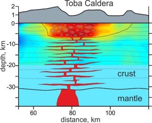
Seismic tomography that uses background or ambient seismic noise has become a powerful technique for studying the crust and lithosphere when small-amplitude short-wavelength Rayleigh and Love surface waves are monitored to pick up subsurface reflecting bodies and measure variation in wave speed with depth. The greater the density of seismometers deployed, the finer the resolution of deep crustal features and 40 such detectors are in place around Lake Toba. A team of Russian, French and German geophysicists have reported new results bearing on how magma may be accumulating beneath the vast caldera (Jaxibulatov, K. et al. 2014. A large magmatic sill complex beneath the Toba caldera. Science, v. 346, p. 617-619). Down to about 7 km the tomography has picked up a structurally homogeneous low-speed zone directly beneath Samosir Island that the authors attribute to the 73 ka explosive eruption. Beneath that several magma sills appear to dominate the sub-caldera crust, possibly responsible for the post eruption uplift within the caldera: the precursor to a layered intrusive body and each an increment towards a further huge eruption.
Interpretation of seismic tomography cross section of Toba. Greens to reds increasingly negative shear speed anomaly. Showing magma sills in lower crust and 74 ka damage zone above 7 km. (credit: Jaxibulatov et al. 2014
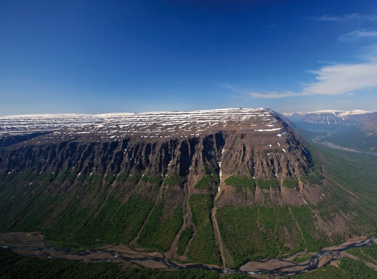
This month’s stunning image from Earth Science Picture of the Day, taken on 8 September this year is of Iceland’s biggest fissure eruption (video clip) since 1875, in the Holuhraun lava field, which began on 31 August this year. The flow is about to meet the Jokulsa a Fjollum, a large river flowing from Iceland’s largest ice cap Vatnajokull. At the time of writing (29 September) lava is flowing along the river bed at around 1 km each day. So far, the flow has spread over 44 square kilometres, and risks blocking the Jokulsa a Fjollum where it flows through a narrow channel bounded by older lava flows. If that happens the river will form a substantial lake until it is able to flow over and erode the bedrock, and will also leave one of the country’s spectacular waterfalls (Sellfoss) dry.
Aerial View of Jökulsá á Fjöllum, Iceland, downstream of Holuhraun (credit: Wikipedia)
The fissure is connected to the large Bárðarbunga stratovolcano that lies beneath Vatnajokull, which is currently showing signs of subsidence, at about 40 cm each day, and seismicity. There are concerns that this activity may presage an eruption there which may melt large volumes of ice and perhaps release a flood or jökulhlaup from beneath the icecap. Such a flood would likely follow the course of the Jokulsa a Fjollum river.
Aside from a swift but highly unlikely abandonment of fossil fuels, reduction of greenhouse warming depends to a large extent, possibly entirely, on somehow removing CO2 from the atmosphere. Currently the most researched approach is simply pumping emissions into underground storage in gas permeable rock, but an important target is incorporating anthropogenic carbon in carbonate minerals through chemical interaction with potentially reactive rocks. In a sense this is a quest to exploit equilibria involving carbon compounds that dominate natural chemical weathering and to sequester CO2 in solid, stable minerals.
The two most likely minerals to participate readily in weathering that involves CO2 dissolved in water are plagioclase feldspar, a calcium-rich aluminosilicate and olivine, a magnesium silicate. Both are abundant in mafic and ultramafic rocks, such as basalt and peridotite, which themselves are among the most common rocks exposed at the Earth’s surface. The two minerals, being anhydrous, are especially prone to weathering reactions involving acid waters that contain hydrogen ions, and in the presence of CO2 they yield stable carbonates of calcium and magnesium respectively. Despite lots of exposed basalts and ultramafic rocks, clearly such natural sequestration is incapable of absorbing emissions as fast as they are produced.
One means of speeding up weathering is to grind up plagioclase- and olivine-bearing rocks and spread the resulting gravel over large areas; as particles become smaller their surface area exposed to weathering increases. Yet it doesn’t take much pondering to realise that a great deal of energy would be needed to produce sufficient Ca- and Mg-rich gravel to take up the approximately 10 billion tonnes of CO2 being released each year by burning fossil fuels: though quick by geological standards the reaction rates involved are painfully slow in the sense of what the climatic future threatens to do. So is there any way in which these reactions might be speeded up?
Two biological agencies are known to accelerate chemical weathering, or are suspected to do so: plant roots and animals that live in soil. Ronald Dorn of Arizona State University set out to investigate the extent to which such agencies do sequester carbon dioxide, under the semi-arid conditions that prevail in Arizona and Texas (Dorn, R.I. 2014. Ants as a powerful biotic agent of olivine and plagioclase dissolution. Geology, v. 42, p. 771-774). His was such a simple experiment that it is a wonder it had not been conducted long ago; but it actually took more than half his working life. Spaced over a range of topographic elevations, Dorn used an augur at each site to drill five half-metre holes into the root mats of native trees, established ant and termite colonies and bare soil surfaces free of vegetation or animal colonies, filling each with sand-sized crushed basalt.
Film poster for Empire of the Ants (starring Joan Collins) (credit: Wikipedia)
Every five years thereafter he extracted the basalt sand from one of the holes at each site and each soil environment. To assess how much dissolution had occurred he checked for changes in porosity, and heated the samples to temperatures where carbonates break down to discover how much carbonate had been deposited. That way he was able to assess the cumulative changes over a 25 year period relative to the bare-ground control sites. The results are startling: root mats achieved 11 to 49 times more dissolution than the control; termites somewhat less, at 10 to 19 times; while ants achieved 53 to 177 times more dissolution. While it was certain that the samples had been continuously exposed to root mats throughout, the degree of exposure to termites and ants is unknown, so the animal enhancements of dissolution are probably minima.
Microscopic examination of mineral grains exposed to ant activity shows clear signs of surface pitting and other kinds of decay. Chemically, the samples showed that exposure to ants consistently increased levels of carbonate in the crushed basalt sand compared with controls, with levels rising by 2 to 4% by mass, with some variation according to ant species. Clearly, there is some scope for a role for ants in carbon sequestration and storage; after all, there are estimated to be around 1013 to 1016 individual ants living in the world’s soils. In the humid tropics the total mass of ants may be up to 4 times greater than all mammals, reptiles and amphibians combined. There is more to learn, but probably a mix of acid secretions and bioturbation by ants and termites is involved in their dramatic effect on weathering. One interesting speculation is that ants may even have played a role in global cooling through the Cenozoic, having evolved around 100 Ma ago.
The relationship between Earth’s complement of free oxygen and life seems to have begun in the Archaean, but it presented a series of paradoxes: produced by photosynthetic organisms oxygen would have been toxic to most other Archaean life forms; its presence drew an important micronutrient, dissolved iron-2, from sea water by precipitation of iron-3 oxides; though produced in seawater there is no evidence until about 2.4 Ga for its presence in the air. It has long been thought that the paradoxes may have been resolved by oxygen being produced in isolated patches, or ‘oases’ on the Archaean sea floor, where early blue-green bacteria evolved and thrived.
A stratigraphic clue to the former presence of such oxygen factories is itself quite convoluted. The precipitation of calcium carbonates and therefore the presence of limestones in sedimentary sequences are suppressed by dissolved iron-2: the presence of Fe2+ ions would favour the removal of bicarbonate ions from seawater by formation of ferrous carbonate that is less soluble than calcium carbonate. Canadian and US geochemists studied one of the thickest Archaean limestone sequences, dated at around 2.8 Ga, in the wonderfully named Wabigoon Subprovince of the Canadian Shield which is full of stromatolites, bulbous laminated masses probably formed from bacterial biofilms in shallow water (Riding, R. et al. 2014. Identification of an Archean marine oxygen oasis. Precambrian Research, v. 251, p. 232-237).
Limestone formed from blue-green bacteria biofilms or stromatolites (credit: Wikipedia)
Limestones from the sequence that stable isotope analyses show to remain unaltered all have abnormally low cerium concentrations relative to the other rare-earth elements. Unaltered limestones from stromatolite-free, deep water limestones show no such negative Ce anomaly. Cerium is the only rare-earth element that has a possible 4+ valence state as well one with lower positive charge. So in the presence of oxygen cerium can form an insoluble oxide and thus be removed from solution. So cerium independently shows that the shallow water limestones formed in seawater that contained free oxygen. Nor was it an ephemeral condition, for the anomalies persist through half a kilometer of limestone.
The study shows that anomalous oxygenated patches existed on the Archaean sea floor, probably shallow-water basins or shelves isolated by the build up of stromatolite reef barriers. For most prokaryote cells they would have harboured toxic conditions, presenting them with severe chemical stress. Possibly these were the first places where oxygen defence measures evolved, that eventually led to more complex eukaryote cells that not only survive oxygen stress but thrive on its presence. That conjecture is unlikely to be fully proved, since the first undoubted fossils of eukaryote cells, known as acritarchs, occur in rocks that are more than 800 Ma years younger.
Plot the times of peaks in the rates of extinction during the Mesozoic against those of flood basalt outpourings closest in time to the die-offs and a straight line can be plotted through the data. There is sufficiently low deviation between it and the points that any statistician would agree that the degree of fit is very good. Many geoscientists have used this empirical relationship to claim that all Mesozoic mass extinctions, including the three largest (end-Permian, end-Triassic and end-Cretaceous) were caused in some way by massive basaltic volcanism. The fact that the points are almost evenly spaced – roughly every 30 Ma, except for a few gaps – has suggested to some that there is some kind of rhythm connecting the two very different kinds of event.
Major Mesozoic extinctions and flood basalt events (credit: S Drury)
Leaving aside that beguiling periodicity, the hypothesis of a flood-basalt – extinction link has a major weakness. The only likely intermediary is atmospheric, through its composition and/or climate; flood volcanism was probably not violent. Both probably settle down quickly in geological terms. Moreover, flood basalt volcanism is generally short-lived (a few Ma at most) and seems not to be continuous, unlike that at plate margins which is always going on at one or other place. The great basalt piles of Siberia, around the Central Atlantic margins and in Western India are made up of individual thick and extensive flows separated by fossil soils or boles. This suggests that magma blurted out only occasionally, and was separated by long periods of normality; say between 10 and 100 thousand years. Evidence for the duration of major accelerations, either from stratigraphy and palaeontology or from proxies such as peaks and troughs in the isotopic composition of carbon (e.g. EPN Ni life and mass extinction) is that they too occurred swiftly; in a matter of tens of thousand years. Most of the points on the flood-basalt – extinction plot are too imprecise in the time dimension to satisfy a definite relationship. Opinion has swung behind an instantaneous impact hypothesis for the K-P boundary event rather than one involving the Deccan Traps in India, simply because the best dating of the Deccan suggests extinction seems to have occurred when no flows were being erupted, while the thin impact-related layer in sediments the world over is exactly at the point dividing Cretaceous flora and fauna from those of the succeeding Palaeogene.
Yet no such link to an extraterrestrial factor is known to exist for any other major extinctions, so volcanism seems to be ‘the only game in town’ for the rest. Until basalt dating is universally more precise than it has been up to the present the case is ‘not proven’; but, in the manner of the Scottish criminal law, each is a ‘cold case’ which can be reopened. The previous article hardens the evidence for a volcanic driver behind the greatest known extinction at the end of the Permian Period. And in short-order, another of the Big Five seems to have been resolved in the same way. A flood basalt province covering a large area of west and north-west Australia (known as the Kalkarindji large igneous province)has long been known to be of roughly Cambrian age but does it tie in with the earliest Phanerozoic mass extinction at the Lower to Middle Cambrian boundary? New age data suggests that it does at the level of a few hundred thousand years (Jourdan, F. et al. 2014. High-precision dating of the Kalkarindji large igneous province, Australia, and synchrony with the Early-Middle Cambrian (Stage 4-5) extinction. Geology, v. 42, p. 543-546). The Kalkarindji basalts have high sulfur contents and are also associated with widespread breccias that suggest that some of the volcanism was sufficiently explosive to have blasted sulfur-oxygen gases into the stratosphere; a known means of causing rapid and massive climatic cooling as well as increasing oceanic acidity. The magma also passed through late Precambrian sedimentary basins which contain abundant organic-rich shales that later sourced extensive petroleum fields. Their thermal metamorphism could have vented massive amounts of CO2 and methane to result in climatic warming. It may have been volcanically-driven climatic chaos that resulted in the demise of much of the earliest tangible marine fauna on Earth to create also a sudden fall in the oxygen content of the Cambrian ocean basins.
The greatest mass extinction of the Phanerozoic closed the Palaeozoic Era at the end of the Permian, with the loss of perhaps as much as 90% of eukaryote diversity on land and at sea. It was also over very quickly by geological standards, taking a mere 20 thousand years from about 252.18 Ma ago. There is no plausible evidence for an extraterrestrial cause, unlike that for the mass extinction that closed the Mesozoic Era and the age of dinosaurs. Almost all researchers blame one of the largest-ever magmatic events that spilled out the Siberian Traps either through direct means, such as climate change related to CO2, sulfur oxides or atmospheric ash clouds produced by the flood volcanism or indirectly through combustion of coal in strata beneath the thick basalt pile. So far, no proposal has received universal acclaim. The latest proposal relies on two vital and apparently related geochemical observations in rocks around the age of the extinctions (Rothman, D.H. et al. 2014. Methanogenic burst in the end-Permian carbon cycle. Proceedings of the National Academy of the United States, v. 111, p. 5462-5467).
In the run-up to the extinction carbon isotopes in marine Permian sediments from Meishan, China suggest a runaway growth in the amount of inorganic carbon (in carbonate) in the oceans. The C-isotope record from Meishan shows episodes of sudden major change (over ~20 ka) in both the inorganic and organic carbon parts of the oceanic carbon cycle. The timing of both ‘excursions’ from the long-term trend immediately follows a ‘spike’ in the concentration of the element nickel in the Meishan sediments. The Ni almost certainly was contributed by the massive outflow of basalt lavas in Siberia. So, what is the connection?
Some modern members of the prokaryote Archaea that decompose organic matter to produce methane have a metabolism that depends on Ni, one genus being Methanosarcina that converts acetate to methane by a process known as acetoclastic methanogenesis. Methanosarcina acquired this highly efficient metabolic pathway probably though a sideways gene transfer from Bacteria of the class Clostridia; a process now acknowledged as playing a major role in the evolution of many aspects of prokaryote biology, including resistance to drugs among pathogens. Molecular-clock studies of the Methanosarcina genome are consistent with this Archaea appearing at about the time of the Late Permian. A burst of nickel ‘fertilisation’ of the oceans may have resulted in huge production of atmospheric methane. Being a greenhouse gas much more powerful than CO2, methane in such volumes would very rapidly have led to global warming. Before the Siberian Traps began to be erupted nickel would only have been sufficiently abundant to support this kind of methanogen around ocean-floor hydrothermal springs. Spread globally by eruption plumes, nickel throughout the oceans would have allowed Methanosarcina or its like to thrive everywhere with disastrous consequences. Other geochemical processes, such as the oxidation of methane in seawater, would have spread the influence of the biosphere-lithosphere ‘conspiracy’. Methane oxidation would have removed oxygen from the oceans to create anoxia that, in turn, would have encouraged other microorganisms that reduce sulfate ions to sulfide and thereby produce toxic hydrogen sulfide. That gas once in the atmosphere would have parlayed an oceanic ‘kill mechanism’’ into one fatal for land animals.
There is one aspect that puzzles me: the Siberian Traps probably involved many huge lava outpourings every 10 to 100 ka while the magma lasted, as did all other flood basalt events. Why then is the nickel from only such eruption preserved in the Meishan sediments, and if others are known from marine sediments is there evidence for other such methanogen ‘blooms’ in the oceans?
A large number of water-oriented tropes have been applied to Earth for ‘artistic effect’, ranging from Waterworld to the Blue Planet, but from a geoscientific perspective H2O in its many forms – liquid, solid, gas, supercritical fluid and chemically bound – has as much influence over the way the world works as do its internal heat production and transfer. Leaving aside surface processes, the presence of water has dramatic effects on the temperature at which rocks – felsic, mafic and ultramafic – begin to melt and deform and on the rates of important chemical reactions bound up with internal processes.
For a long while many geologists believed that the oceans were the product of water being transferred from the mantle by degassing through volcanoes so that the deep Earth has steadily been desiccated. But now it has become clear that such is the rate at which subduction can shift water back to the mantle that the entire volume of modern ocean water may have been cycled back and forth more than 3 times in Earth history (see Subduction and the water cycle). Besides, it is conceivable that accretion of cometary material up to about 3.8 Ga may have delivered the bulk of it.
An important aspect of the deep part of the water cycle concerns just how far into the mantle subduction can transport this most dominant volatile component of our planet. Ultra high-pressure experimental petrology has reached the stage when conditions at depths more than halfway to the core-mantle boundary (pressures up to 50 GPa) can be sustained using diamond anvils surrounding chemical mixtures that approximate mantle ultramafic materials. Previously, it was thought that serpentinite, the hydrous mineral most likely to be subducted, broke down into magnesium-rich, anhydrous silicates at around 1250 km down. This would prevent the deepest mantle from gaining any subducted water and retaining any that it had since the Earth formed. A team of Japanese geochemists has discovered a hint that hydrous silicates can, through a series of phase changes, achieve stability under the conditions of the deepest mantle (Nishi, M. 2014. Stability of hydrous silicate at high pressures and water transport to the deep lower mantle. Nature Geoscience, v. 7, p. 224-227). Their experiments yielded a yet unnamed mineral (phase H or MgSiH2O4) from approximate mantle composition that could remain stable in subducted slabs down to the core-mantle boundary. This development may help explain why the lowermost mantle is able to participate in plume activity through reduction in viscosity at those depths.
A parallel discovery concerns conditions at the base of the upper mantle; the 410 to 660 km mantle seismic transition zone. It comes from close study of a rare class of Brazilian diamonds that have been swiftly transported to the Earth’s surface from such depths, probably in kimberlite magma pipes, though their actual source rock has yet to be discovered. These ultra-deep diamonds prove to contain inclusions of mantle materials from the transition zone (Pearson, D.G. and 11 others 2014. Hydrous mantle transition zone indicated by ringwoodite included within diamond. Nature, v. 507, p. 221-224). Australian geochemist Ted Ringwood pioneered the idea in the 1950s and 60s that the mantle transition zone might be due to the main mantle mineral olivine ((Mg,Fe)2SiO4) being transformed to structures commensurate with extremely high pressures, including one akin to that of spinel. Such a mineral was first observed in stony meteorites that had undergone shock metamorphism, and was dubbed ringwoodite in honour of its eponymous predictor. Yet ringwoodite had never been found in terrestrial rocks, until it turned up in the Brazilian diamonds thanks to Pearson and colleagues.
Partial cross-section of the Earth showing the location of ringwoodite in the mantle Credit: Kathy Mather
Earlier experimental work to synthesise ultra-deep minerals discovered that ringwoodite may contain up to 2% water (actually OH groups) in its molecular lattice: an astonishing thing for material formed under such extreme conditions. The ringwoodite inclusions in diamond show infrared spectra that closely resemble its hydrous form. From this it may be inferred that the 401-660 km transition zone contains a vast amount of water; roughly the same as in all the oceans combined, though the find is yet to be confirmed in a wider selection of diamonds. One of the puzzles about diamondiferous kimberlites is that the magma must have been rich in water and carbon dioxide. That can now be explained by volatile-rich materials at the depths where diamonds form, But that does not necessarily implicate the whole transition zone: there may be pockets ripe for kimberlitic magma formation in a more widely water-poor mantle.
Related articles
Keppler, H. 2014. Earth’s deep water reservoir. Nature , v. 507, p. 174-175
Recently there have been worrying accounts about pathogens, for instance the viruses that cause foot and mouth disease in livestock, flu in humans and other animals and the sheep disease bluetongue carried by tiny midges, being transported for thousands of kilometres in dust storms. They raise the question of whether or not in the past organisms small enough to be carried by winds in aerosol suspension might have helped colonise regions distant from where they evolved.
The 600 square kilometre caldera lake of Taupo on New Zealand’s North Island. (Photo credit: Wikipedia)
Studies of volcanic ash thought to have been transported at high latitudes in the Southern Hemisphere from a 25 thousand-year old major volcanic eruption on the North Island of New Zealand add volcanic activity to violent meteorological phenomena as a possible means of transport (Van Eaton, A.R. et al. 2013. High-flying diatoms: Widespread dispersal of microorganisms in an explosive volcanic eruption. Geology, v. 41, p. 1187-1190). Ash from as far as 850 km from the volcano turns out to incorporate abundant remains of diatoms – species of algae that secrete distinctively intricate skeletons made from silica. The volcano, Taupo, erupted from beneath a lake bed, explaining the diatoms’ origin from lake muds and the water column itself. Even details of the organisms’ soft parts and pigmentation are preserved in the ash, suggesting that at least some of them might have been transported alive. Astonishingly, the New Zealand authors’ counts of organic material in the ash suggest that as much as 0.6 km3 of diatom remains were dispersed during the eruption.
Assorted species of diatoms on a microscope slide (credit: Wikipedia)
Violent sub-aqueous eruptions can entrain liquid water as spray as well as water vapour and glassy magma shards, carrying the mixture into the stratosphere, far above wind belts in the lower atmosphere. At such altitudes transport can spread fine aerosols through an entire hemisphere because they remain in suspension for long periods.
Different species of diatom live in subtly different environments, so that their relative proportions and presence or absence in ash provide a ‘fingerprint’ for the volcano responsible. So the discovery by the team from the Victoria University of Wellington (a ‘first’) presents a new tool for identifying the source of ash layers in the volcanic record that came from other volcanoes associated with caldera lakes – common for those capable of launching huge volumes of material aloft, such as Toba that erupted in Sumatra at around 74 ka and may have influenced the first modern human migrants from Africa. But could minute organisms survive both the volcanic heat and blast and a traverse through the dry stratosphere to result in colonisation? If that were possible it would have significant implications for the spread of early life forms during the far more volcanically active Hadean and Archaean Eons of Earth’s history.
Commenting on the article, Jennifer Pike of Cardiff University, UK (Pike, J. 2013. Of volcanoes and diatoms. Geology, v. 41, p. 1199-2000) surmises that diatoms might survive drying out in the stratosphere, provided they were in the form of spores encased in silica. Such spores were not found in the Taupo ash, but who is to say that they will not be discovered in other ancient volcanic ash layers? Spores are extremely durable and other micro-organisms than diatoms produce them and have done in the past.
The Earth’s earliest atmosphere undoubtedly had a chemistry dominated by carbon dioxide and nitrogen, together with transient water vapour, outgassed from volcanoes giving pervasive reducing conditions at the surface and in the oceans. Until the last couple of decades the only clear evidence of a switch to oxidising conditions and presumably significant atmospheric oxygen was direct, mineralogical evidence. The most obvious signs are ancient, reddened soils formed when soluble Fe2+ lost electrons to molecular oxygen to form the distinct red, orange and brown oxides and hydroxides of insoluble Fe3+ that impart a deep staining in even small quantities. Others include the disappearance from river-transported sediments of clearly transported grains of metal sulfides and uranium oxide that remain stable under reducing conditions but quickly break down in the presence of oxygen.
Widespread observations in Precambrian sediments, eventually linked with reliable radiometric ages, strongly suggested a fundamental environmental change at around 2.3 billion years ago: the Great Oxidation Event. A few such signs emerge from somewhat older rocks back to 2.7 Ga, but only the 2.3 Ga event created a permanent feature of our home world; at first toxic to many of the prokaryote life forms of earlier times but eventually a prime condition for the rise of the Eukarya and eventually metazoan animals. Isotopic analysis of sulfur from Precambrian sediments also gave hints of a more complex but much debated transition because of the way S-isotopes fractionate under different environmental conditions. Now other indirect, isotopic approaches to redox conditions have become feasible, with a surprising result: powerful evidence that about 3 billion years ago there was appreciable atmospheric oxygen (Crowe, S.A. et al. 2013. Atmospheric oxygenation three billion years ago. Nature, v. 501, p. 535-538).
The Danish-South African-German-Canadian group relied on a fractionation process among the isotopes of chromium, which can exist in several oxidation states. When minerals that contain Cr3+ are weathered under oxidising conditions to release soluble Cr6+ the loss in solution preferentially removes the 53Cr isotope from residual soil. If the isotope enters groundwater with reducing conditions to precipitate some Cr3+ -rich material yet more 53Cr remains in solution. Eventually such enriched water may enter the oceans, where along with iron and other transition-group metal ions chromium can end up in banded iron formations (BIFs) to preserve isotopic evidence for oxidising conditions along it route from land to sea.
Banded iron formation (BIF) from the Precambrian of North America belonging to the National Museum of Mineralogy and Geology in Dresden, Germany. (credit: Wikipedia)
The team analysed both a palaeosol and a BIF unit from a stratigraphic sequence in the Achaean of NE South Africa that is between 2980 and 2924 Ma old. A substantial proportion of the palaeosol is depleted in 53Cr whereas the lower part of the slightly younger BIF is significantly enriched. Changes in the concentration of redox sensitive elements, such as chromium itself, uranium and iron, in the two lithologies helps confirm the isotopic evidence for a major ~3 Ga oxidation event. It is possible to use the data to estimate what the atmospheric oxygen content might have been at that time: not enough to breathe, but significant at between 6 x 10⁻⁵ to 3 x 10⁻³ the atmospheric level at present. Oxygen can be produced abiogenically through irradiation of water vapour in the atmosphere as well as by organic photosynthesis. However, the first route seems incapable of yield more than a billionth of present atmospheric concentrations, so the spotlight inevitably falls on a ‘much deep history’ of the action of blue-green bacteria (cyanobacteria) than hitherto suspected.
Hydrothermal vent at the mid-Atlantic Ridge (credit: Wikipedia)
Occasionally, journals not usually associated with mainstream geosciences publish something startling, but easily missed. Nature of 12 September 2013 alerted me to just such an oddity. It seems that the chemistry of sea-floor hydrothermal vents potentially can generate electrical power (Yamamoto, M. et al. 2013. Generation of electricity and illumination by an environmental fuel cell in deep-sea hydrothermal vents. Angewandte Chemie, online DOI: 10.1002/ange.201302704).
The team from the Japan Agency for Marine-Earth Science and Technology, the Riken Centre for Sustainable Resource Science and the University of Tokyo used a submersible ROV to suspend a fuel cell based on a platinum cathode and iridium anode in hydrothermal vents that emerge from the Okinawa Trough off southern Japan at a depth of over 1 km. It recorded a tiny, but significant power generation of a few milliwatts.
The fluids issuing from the vents are at over 300°C while seawater is around 4°C, creating a very high thermal gradient. More importantly, the fluid-seawater interface is also a boundary between geochemically very different conditions. The fluids are highly acidic (pH 4.8) compared with the slight alkalinity of seawater, and contain high concentrations of hydrogen and hydrogen sulfide but undetectable oxygen (sea water is slightly oxygenated).
The fuel cell was designed so that iridium in the anode speeds up the oxidation of H2S at the geochemical interface which yields the electrons necessary in electrical currents. The experiment neatly signified its success by lighting up three light-emitting diodes.
Does this herald entirely new means of renewable power generation? Perhaps, if the fuel cell is scaled-up enormously. Yet, the very basis of oxidation and reduction is expressed by the mnemonic OILRIG (Oxidation Is Loss Reduction Is Gain – of electrons) and any potential redox reaction in nature has potential, even plants can be electricity producers. In fact all fuel cells exploit oxidation reactions of one kind or another.
In its 125th year the Geological Society of America is publishing invited reviews of central geoscience topics in its Bulletin. They seem potentially useful for both undergraduate students and researchers as accounts of the ‘state-of-the-art’ and compendia of references. The latest focuses on major controls on past sea-level changes by processes that operate in the solid Earth (Conrad, C.P. 2013. The solid Earth’s influence on sea level. Geological Society of America Bulletin, v. 125, p. 1027-1052), a retrospective look at how geoscientists have understood large igneous provinces (Bryan, S. E. & Ferrari, L. 2013. Large igneous provinces and silicic large igneous provinces: Progress in our understanding over the last 25 years. Geological Society of America Bulletin, v. 125, p. 1053-1078) and the perennial topic of how granites form and end up in intrusions (Brown, M. 2013. Granite: From genesis to emplacement Geological Society of America Bulletin, v. 125, p. 1079-1113).
Sea level change
Conrad covers sea-level changes on the short- (1 to 100 years), medium- (1 to 100 ka) and long term (1 to 100 Ma). The first two mainly result from local deformation of different kinds associated with glacial loading and unloading. These result in changes in the land surface, the sea surface nearby and on thousand year to 100 ka timescales to ups and downs of the sea-bed. Global sea-level changes due to melting of continental glaciers at the present day amount to about half the estimated 2 to 3 mm of rise each year. But increasingly sensitive measures show it is more complex as the rapid shifts of mass involved in melting ice also result in effects on the solid Earth. At present solid mass is being transferred polewards, but at rates that differ in Northern and Southern hemispheres and which are changing with anthropogenic influences on glacial melting. Viscous movement of the solid Earth is so slow that effects from previous glacial-interglacial episodes continue today. As a result rapid elastic movements are tending to produce relative sea-level falls in polar regions of up to 20 mm per year with rising sea level focusing on areas between 30°N and 30°S. The influence of the slower viscous mass transfer has an opposite sense: sea-level rise at high latitudes. Understanding the short- and medium-term controls is vital in predicting issues arising in the near future from natural and anthropogenic change.
Comparison of two sea level reconstructions during the last 500 Ma. (credit: Wikipedia)
Most geologists are concerned in practice with explanations for major sea-level changes in the distant past, which have a great deal to do with changes in the volumes of the ocean basins. If the global sea-floor rises on average water is displaced onto former land to produce transgressions, and subsidence of the sea floor draws water down from the land. Conrad gives a detailed account of what has been going on since the start of the Cretaceous Period, based on the rate of sea-floor spreading, marine volcanism and sedimentation, changes in the area of the ocean basins and the effects of thermally-induced uplift and subsidence of the continents, showing how each contribution acted cumulatively to give the vast transgressions and regressions that affected the late Phanerozoic. On the even longer timescale of opening and closing of oceans and the building and disintegration of supercontinents the entire mantle becomes involved in controls on sea level and a significant amount of water is chemically exchanged with the mantle.
Large igneous provinces
The Web of Science database marks the first appearance in print of “large igneous province” in 1993, so here is a topic that is indeed new, although the single-most important attribute of LIPs, ‘flood basalt’ pops up three decades earlier and the term ‘trap’ that describes their stepped topography is more than a century old. Bryan and Ferrari are therefore charting progress in an exciting new field, yet one that no human – or hominin for that matter – has ever witnessed in action. One develops, on average, every 20 Ma and since they are of geologically short duration long periods pass with little sign of one of the worst things that our planet can do to the biosphere. In the last quarter century it has emerged that they blurt out the products of energy and matter transported as rising plumes from the depths of the mantle; they, but not all, have played roles in mass extinctions; unsuspected reserves of precious metals occur in them; they play some role in the formation of sedimentary basins and maturation of petroleum and it seems other planets have them – a recipe for attention in the early 21st century. Whatever, Bryan and Ferrari provide a mine of geological entertainment.
In comparison, granites have always been part of the geologist’s canon, a perennial source of controversy and celebrated by major works every decade, or so it seems, with twenty thousand ‘hits’ on Web of Science since 1900 (WoS only goes back that far). Since the resolution of the plutonist-neptunist wrangling over granite’s origin one topic that has been returned to again and again is how and where did the melting to form granitic magma take place? If indeed granites did form by melting and not as a result of ‘granitisation. Lions of the science worried at these issues up to the mid 20th century: Bowen, Tuttle, Read, Buddington, Barth and many others are largely forgotten actors, except for the credit in such works as that of Michael Brown. Experimental melting under changing pressure and temperature, partial pressures of water, CO2 and oxygen still go on, using different parent rocks. One long-considered possibility has more or less disappeared: fractional crystallisation from more mafic magma might apply to other silicic plutonic rocks helpfully described as ‘granitic’ or called ‘granitoids’, but granite (sensu stricto) has a specific geochemical and mineralogical niche to which Brown largely adheres. For a while in the last 40 years classification got somewhat out of hand, moving from a mineralogical base to one oriented geochemically: what Brown refers to as the period of ‘Alphabet Granites’ with I-, S- A- and other-type granites. Evidence for the dominance of partial melting of pre-existing continental crust has won-out, and branched into the style, conditions and heat-source of melting.
Typical granite tor near Kisumu, Kenya (credit: Wikipedia)
All agree that magmas of granitic composition are extremely sticky. The chemical underpinnings for that and basalt magma’s relatively high fluidity were established by physical chemist Bernhardt Patrick John O’Mara Bockris (1923-2013) but barely referred to, even by Michael Brown. Yet that high viscosity has always posed a problem for the coalescence of small percentages of melt into the vast blobs of low density liquid able to rise from the deep crust to the upper crust. Here are four revealing pages and ten more on how substantial granite bodies are able to ascend, signs that the puzzle is steadily being resolved. Partial melting implies changes in the ability of the continental crust to deform when stressed, and this is one of the topics on which Brown closes his discussion, ending, of course, on a ‘work in progress’ note that has been there since the days of Hutton and Playfair.
The Afar Depression of Ethiopia and Eritrea is a feature of tectonic serendipity. It is unique in showing on land the extensional processes and related volcanism that presage sea-floor spreading. Indeed it hosts three rift systems and a triple junction between the existing Red Sea and Gulf of Aden spreading centres and the East African Rift System that shows signs of future spalling of Somalia from Africa. Afar has been a focus of geoscientific attention since the earliest days of plate theory but practical interest has grown rapidly over the last decade or so when the area has become significantly more secure and safe to visit. Two recent studies seem to have overturned one of the most enduring assumptions about what drives this epitome of continental break-up.
Simulated perspective view of the Afar depression from the south (credit: Wikipedia)
From the obvious thermal activity deep below Afar, linked with volcanism and high heat flow, a mantle host spot and rising plume of deep mantle has been central to ideas on the tectonics of the area. A means of testing this hypothesis is the use of seismic data to assess the ductility and temperature structure of deep mantle through a form of tomography. The closer the spacing of seismic recording stations and the more sensitive the seismometers are the better the resolution of mantle structure. Afar now boasts one of the densest seismometer networks, rivalling the Earthscope USArray. http://earth-pages.co.uk/2009/11/01/the-march-of-the-seismometers/ and it is paying dividends (Hammond, J.O.S. and 10 others 2013. Mantle upwelling and initiation of rift segmentation beneath the Afar Depression. Geology, v. 41, p.635-638). The study brought together geoscientists from Britain, the US, Ethiopia, Eritrea and Botswana, who used data from 244 seismic stations in the Horn of Africa to probe depths down to 400 km with a resolution of about 50 km.
The tomographic images show no clear sign of the kind of narrow plume generally aasociated with the notion of a ‘hot spot’. Instead they pick out shallow (~75 km depth) P- and S-wave low-velocity features that follow the axes of the three active rift systems. The features coalesce at depth; in some respects the opposite of a classic plume that has a narrow ‘stem’ that swells upwards to form a broad ‘head’. If there ever was an Afar Plume it no longer functions. Instead, the rifts and associated lithospheric thinning are associated with a mantle upwelling that is being emplaced passively in the space made available by extensional tectonics. This is closely similar to what goes on beneath active and well-established mid-ocean spreading centres where de-pressuring of the rising mantle results in partial melting and basaltic magmatism along the rift system. Perhaps this is a sign that full sea-floor spreading in Afar is imminent, at least on geological timescales.
Simplified geologic map of the Afar Depression. (credit: Wikipedia after Beyene and Abdelsalam (2005))
For once, mantle geochemists and geophysicists have data that support a common hypothesis (Ferguson, D.J. and 8 others 2013. Melting during late-stage rifting in Afar is hot and deep. Nature, v. 499, p. 70-73). This US-British-Ethiopian team compares the trace element geochemistry of Recent basaltic lavas erupted along the axis of the Afar rift that links with the Red Sea spreading centre with equally young lavas from volcanoes some 20 km from the axis. Both sets of lavas are a great deal more enriched in incompatible trace elements that are generally enriched in melt compare with source than are ocean-floor basalts sampled from the mid-Red Sea rift. Modelling rare-earth element patterns in particular suggests that partial melting is going on at depths where garnet is stable in the mantle instead of spinel. This suggests that a strong layer, about 85 km down in the upper mantle is beginning to melt – magmas formed by small degrees of partial melting generally contain higher amounts of incompatible trace elements than do the products of more extensive melting. Estimates of the temperature of melting from lavas extruded at the rift axis than off-axis are significantly higher than expected at this depth suggesting that deeper mantle is rising faster than it can lose heat.
The depth of melting tallies with the thermal feature picked out by seismic tomography. The two teams converge on passively induced upwelling of hot asthenosphere while the Afar lithosphere is slowly being extended. The degree of melting beneath Afar is low at present, so that to become like mid-ocean ridge basalts a surge in the fraction of melting is needed. That would happen if the strong mantle layer fails plastically so that more asthenosphere can rise higher by passive means. The geochemists persist in an appeal to an Afar Plume for the 30 Ma old flood basalts that plaster much of the continental crust outside Afar. Those plateau-forming lavas, however, are little different in their trace element geochemistry from off-axis Afar basalts. Yet they are not obviously associated with an earlier episode of lithospheric extension and passive mantle upwelling. Most geologists who have studied the flood basalts would agree that they preceded the onset of rifting but have little idea of the actual processes that went on during that mid-Oligocene volcanic cataclysm.
People have a keen eye for unusual objects and an even keener one for the aesthetic. Fossil echinoderms with their five-fold starry shape have been enduringly popular as trinkets since the Palaeolithic. Astonishingly, the gravel terrace at Swanscombe that yielded skull fragments of 400 ka Homo erectus plus many Acheulean tools also contained a flint bi-face ‘hand axe’ with a near perfect echinoid in its blunt grip. It cannot be proven, but the object seems to refute the idea that an artistic sense only arose with anatomically modern humans in the last 100 ka. Our immediate ancestors of the Neolithic sometimes took collecting to extremes in graves half full of fossil sea urchins (McNamara, K.J. 2007. Shepherds’ crowns, fairy loaves and thunderstones: the mythology of fossil echinoids in England. In: Piccardi, L. & Masse, W.B. Myth and Geology. Geological Society, London, Special Publication 273, 279–294).
Before the invention of metal smelting native gold, iron and copper appear in the archaeological record, undoubtedly because they look and indeed feel so different from the usual pebbles on the beach or just lying around. It is just that element of the odd that continues to draw people, including scientists, into a perpetually stooped posture when the walk across surfaces scattered with pebbles and boulders. The habit is especially hard to shake off for the meteoriticist whose hunting grounds are desert plains and ice caps where oddities are easy to spot, even when rare. So it is interesting when such dogged searchers encounter evidence of long-dead people having done much the same.
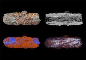
By 5300 years ago people had settled in small farming communities in the Nile Valley eventually to develop on the shores of lake – now represented by several smaller water bodies – what is regarded as the world’s first city near modern Faiyum. These Predynastic people buried their dead nearer to the Nile at Gerzeh, often sending them off with grave goods. The site has been continually excavated by professional archaeologists for more than a century, beginning with Sir Flinders Petrie. Two of the graves contained metallic iron beads, which presented a puzzle as iron smelting is only known from the 6th century BCE onwards. Unsurprisingly, the beads came to be regarded as artefacts wrought from an iron meteorite, though their highly altered nature and intrinsic value thwarted attempts at full analysis. Geochemists from the Open and Manchester Universities, and the Natural History Museum have now resolved the issue (Johnson, D. et al. 2013. Analysis of a prehistoric Egyptian iron bead with implications for the use and perception of meteorite iron in ancient Egypt. Meteoritics and Planetary Science, on-line, DOI: 10.1111/maps.12120). Non-destructive electron microscopy and X-ray tomography reveal, respectively, clear signs of the banded Widmanstätten structures and traces of nickel-rich iron alloy (taenite) that typify iron meteorites but are absent from smelted iron. The beads were clearly beaten and rolled into shape, but this working did not destroy the tell-tale evidence of their origin.
Optical, microprobe and CT-scan images of Predynastic iron bead from the Nile Valley (credit: Open University)
This provenance tallies with the appearance in early New Kingdom hieroglyphs of the term biA-n-pt – literally iron-from-the-sky – which was adopted for smelted iron when first made in the 26 to 27th Dynasties. But pharaonic iron was not a poor relation of gold, regarded as flesh of the gods and hence featuring in the masks of Pharaohs such as Tutankhamen, but supposedly what their bones were made from.
Way back in the mists of time, say around 1970-71, an idea was doing the rounds that because the thermal conductivity of continental crust is lower than that of the ocean floor it should allow thermal energy to build up in the mantle beneath. In turn that might somehow encourage the formation of hot spots and a shallower depth to the asthenosphere: the outcome might be to encourage rifting of weakened lithosphere and ultimately a new round of sea-floor spreading. The case often cited was the Atlantic – North and South – since there are eight hotspots currently on the mid-Atlantic ridge. Africa was another popularised case with a great many broad domes associated with Cenozoic volcanism, and the link between formation of the East African Rift System, hot spots and doming had already been suggested. Africa has barely drifted for around 100 Ma and the domes were supposed to have formed by the build up of heat in the mantle beneath. Geoscience moved on to clearly demonstrate the coincidence of large igneous provinces and flood basalt volcanism with the initiation of Atlantic spreading in the form of the Central Atlantic and Brito-Arctic LIPs during initial opening of the South and North Atlantic at the end of the Triassic and during the Palaeocene respectively. But the role of continental insulation became a bit of backwater compared with notions of mantle plumes emanating at the core-mantle boundary. Well, it’s back.
The Mid-Atlantic Ridge (credit: Wikipedia)
There is now a vast repository of ocean-floor lavas that formed at mid-ocean ridges in the past, thanks to the international Deep Sea and Ocean Drilling Programmes begun in 1968 about when the heyday of plate tectonics really got underway. In the last 45 years there have also been great advances in igneous geochemistry and its interpretation, including relations with mantle melting temperatures. Geochemists at the Friedrich-Alexander-Universiteit in Erlangen, Germany have re-examined the major-element geochemistry of 184 glassy ocean-floor basalts from drill sites of different ages on the floor of the Atlantic Ocean and compared them with 157 from the Pacific. To avoid the possible influence of plume-related heating, the sites were chosen well away from the tracks of existing hot spots. Mantle temperature can be assessed from the sodium and iron content of basalts, Na decreasing with higher temperatures and Fe doing the reverse (Brandl, P.A. et al. 2013. High mantle temperatures following rifting cause by continental insulation. Nature Geoscience, v. 6, p. 391-394). Atlantic samples show increasing Na and decreasing Fe contents in progressively younger basalts, i.e. a trend with time of decreasing mantle temperature such that the oldest (~166 Ma) record 150°C higher mantle temperature than the youngest, with a similar result for the Indian Ocean floor. No such trend is present in samples from the same age range of the Pacific Ocean floor. At around 170 Ma the mid-Atlantic Ridge was close to the continental lithosphere of the Americas and Africa, whereas the East Pacific Rise was at least 2000 km from any continental margin. Younger Atlantic samples formed progressively further from its shores record cooling of the mantle source.
A prediction of the model is that the converse, continental accretion to form supercontinents such as Pangaea, should rapidly have caused considerable warming in the mantle beneath them. This suggests that the formation of supercontinents, or even less substantial continents, should carry the seeds of their re-fragmentation, as Africa is currently demonstrating by the separation of Arabia since the Red Sea began to open some 15 Ma ago, which Somalia and much of eastern Kenya and Tanzania seem destined to follow once the East African Rift System ‘gets steam up’.
Related articles
Langmuir, C. 2013. Older and hotter. Nature Geoscience, v. 6, p. 332-333
At first reading this item’s title might seem to convey nonsense, yet there is an interesting relationship between these two very different disciplines. It concerns the pillaging of South and Central America by conquistadors who followed Columbus’s pioneering route across the North Atlantic in 1492. Aside from glory their motive was profit, and that was most conveniently concentrated in the form of gold and silver, to be found in abundance among the native people of what came to be known as the Americas. Once such plunder declined silver ores were soon discovered in Peru and Mexico, thereby maintaining the supply. Bullion or plate – so named from the fact that precious metal was most often transported in the form of sheets – was the major cargo of the great treasure ships in the period from 1515 to 1650. It is remembered in such geographic names as the Rio de la Plata separating modern Argentina and Uruguay.
Klaus Kinski, well into his role as an insane conquistador, disputes the script with director Werner Herzog while shooting “Aguirre, The Wrath Of God” (credit: Flickr p373)
It might seem that when such a vast amount of loot entered Europe the buying power of silver in particular would have fallen to result in inflation in the price of basic commodities, much as printing paper money may have that result nowadays. Indeed, over those roughly 150 years prices increased by as much as five times. Another factor was a tendency for silver supply to be augmented simply by debasing newly minted currency with other metals. Yet another is that over the same period China adopted silver as a money commodity increasing demand and so spurring exploration and advances in metallurgical extraction from new ores. Furthermore, the entire fabric of economy in Europe began to shift as feudalism began to be supplanted by capitalism at the close of Medieval times. The sheer complexity of competing factors has made the so-called ‘Price Revolution’ of the 16th and 17th centuries a thorny issue for economic historians. This is where geochemists found that they had a ‘shout’ in what Thomas Carlisle dubbed the ‘dismal science’.
Silver ores also contain lead and copper, which inevitably contaminate silver metal extracted from them. Depending on the processes involved in mineralisation the abundances of both metals vary from mine to mine. More tellingly, so do the relative proportions of the different Pb and Cu isotopes, Pb isotopes reflecting the age of the rocks in which ores are found. Inherited by coinage, the isotopes can be used to assess provenance of coins (Desaulty, A.-M. & Albarede, F. 2013. Copper, lead and silver isotopes solve a major economic conundrum of Tudor and early Stuart Europe. Geology, v. 41, p. 135-138), while the dates embossed on coins at the mint potential chart the course of the bullion trade. Desaulty and Albarede show that silver from the vast Potosí mine in modern Bolivia opened by conquistadors barely shows up in British coinage of the period, which is dominated with Mexican isotopic signatures as well as those from European mines. The latter account almost exclusively for the coinage of the late Medieval period. The conclusion is that the huge potential of Potosí served the needs of Spanish entrepreneurs though a trans-Pacific Spanish trade in which Bolivian silver bought goods from China, including gold. Spanish coins, on the other hand, show little of either Bolivian or Mexican silver, suggesting that Spanish world trade may well have used American bullion directly to purchase goods throughout its sphere of influence centred on the Philippines, while Mexican silver engaged in European trade and also found its way into the British economy by way of the slave trade.
Although Desaulty and Albarede claim to have solved a ‘conundrum’ it seems more likely that their revelations will make historians of post-Medieval economics scratch their heads even more.
Geologists realized long ago that volcanic activity can have a profound effect on local and global climate. For instance, individual large explosive eruptions can punch large amounts of ash and sulfate aerosols into the stratosphere where they act to reflect solar radiation back to space, thereby cooling the planet. The 1991 eruption of Mt Pinatubo in the Philippines ejected 17 million tones of SO2; so much that the amount of sunlight reaching the Northern Hemisphere fell by around 10% and mean global temperature fell by almost 0.5 °C over the next 2 years. On the other hand, increased volcanic emissions of CO2 over geologically long periods of time are thought to explain some episodes of greenhouse conditions in the geological past.
Ash plume of Mount Pinatubo during its 1991 eruption. (credit: Wikipedia)
The converse effect of climate change on volcanism has, however, only been hinted at. One means of investigating a possible link is through the records of volcanic ash in sea-floor sediment cores in relation to cyclical climate change during the last million years. Data relating to the varying frequency volcanic activity in the circum Pacific ‘Ring of Fire’ has been analysed by German and US geoscientists (Kutterolf, S. et al. 2013. A detection of Milankovich frequencies in global volcanic activity. Geology, v. 41, p. 227-230) to reveal a link with the 41 ka periodicity of astronomical climate forcing due to changes in the tilt of the Earth’s axis of rotation. This matches well with the frequency spectrum displayed by changes in oxygen isotopes from marine cores that record the waxing and waning of continental ice sheets and consequent falls and rises in sea level. Yet there is no sign of links to the orbital eccentricity (~400 and ~100 ka) and axial precession (~22 ka) components of Milankovitch climatic forcing. An interesting detail is that the peak of volcanism lags that of tilt-modulated insolation by about 4 ka.
At first sight an odd coincidence, but both glaciation and changing sea levels involve shifting the way in which the lithosphere is loaded from above. With magnitudes of the orders of kilometres and hundreds of metres respectively glacial and eustatic changes would certainly affect the gravitational field. In turn, changes in the field and the load would result in stress changes below the surface that conceivably might encourage subvolcanic chambers to expel or accumulate magma. Kutterolf and colleagues model the stress from combined glacial and marine loading and unloading for a variety of volcanic provinces in the ‘Ring of Fire’ and are able to show nicely how the frequency of actual eruptions fits changing rates of deep-crustal stress from their model. Eruptions bunch together when stress changes rapidly, as in the onset of the last glacial maximum and deglaciations, and also during stadial-interstadial phases.
Whether or not there may be a link between climate change and plate tectonics, and therefore seismicity, is probably unlikely to be resolved simply because records do not exist for earthquakes before the historic period. As far as I can tell, establishing a link is possible only for volcanism close to coast lines, i.e. in island arcs and continental margins, and related to subduction processes, because the relative changes in stress during rapid marine transgressions and recessions would be large.. Deep within continents there may have been effects on volcanism related to local and regional ice-sheet loading. In the ocean basins, however, there remains a possibility of influences on the activity of ocean-island volcanoes, though whether or not that can be detected is unclear. Some, like Kilauea in Hawaii and La Palma in the Canary Islands, are prone to flank collapse and consequent tsunamis that could be influenced by much the same process. Another candidate for a climate-linked, potentially catastrophic process is that of destabilisation of marine sediments on the continental edge, as in the Storegga Slide off Norway whose last collapse and associated tsunami around 8 thousand years ago took place during the last major rise in sea level during deglaciation. The climatic stability of the Holocene probably damps down any rise in geo-risk with a link to rapid climate change, which anthropogenic changes are likely to be on a scale dwarfed by those during ice ages.
Landsat image of the Lake Toba caldera, Sumatra (credit: Wikipedia)
The largest volcanic catastrophe during the evolution of humans formed the huge caldera at Lake Toba near the Equator in Sumatra about 70 thousand years ago. Explosive action erupted 2800 cubic kilometres of magma, of which 800 km3 was deposited as thick ash across most of South Asia and the northern Indian Ocean. Sulfates derived from the gas emissions by Toba form clear ‘spikes’ in ice cores from both Greenland and Antarctica. Its effects were global through the mixing of sulfate aerosols in the stratosphere of both hemispheres, encouraged by its position close to the Equator. By reflecting incoming solar energy the aerosols resulted in a century-long 10°C fall in temperature over the Greenland ice cap. Such global cooling almost certainly affected anatomically modern humans, but it is possible that in South Asia Toba had an even more devastating effect.
The Toba ash at the Jwalapuram excavations in South India(Photo credit: Sanjay P. K. via Flickr)
At several sites in the Indian state of Tamil Nadu and in Malaysia Toba ash has buried artifacts that arguably may have been made by the earliest modern emigrants from Africa. Immediately above the ash are yet more tools that suggest humans did survive the eruption. Palaeoanthropologists have argued that the stress of Toba’s environmental effects on all hominins living at the time may have resulted in population crashes from which only the fittest individuals emerged. Major evolutionary changes have been ascribed to ‘bottlenecks’ of that kind to result in changes in human behaviour detectable from the archaeological record, such as the creation of completely new kinds of tools, art and language. However, recent finds in Africa suggest that many such shifts are much older than Toba.
Perhaps Toba’s greatest contribution to palaeoanthropology is that it is an easily recognised event in the geological record, but compared with its sulfate spike in the Greenland ice core at ~71 ka the existing radiometric dates have uncertainties of several thousand years. Using the latest 40Ar/39Ar dating methods on fresh crystals of sanidine (volcanic K-feldspar) from new excavations in Malaysia these uncertainties have been reduced significantly (Storey, M. et al. 2012. Astronomically calibrated 40Ar/39Ar age for the Toba supereruption and global synchronization of late Quaternary records. Proceedings of the National Academy of Sciences, v. 109, p. 19684-18688 ). The sulfate peak and the ash can now be attributed to an age of 73.88 ± 0.32 ka; better than a golden spike in Late Pleistocene stratigraphy. The ice-cores have a check on chronology just beyond the limit of counting annual layering, as do ocean sediment cores for a time older than 14C can ever achieve. Toba now links too with events recorded by the precise U-Th series dating of cave deposits
There is something deeply unsatisfying, even untidy, about a geoscientific history from which the first half billion years is more or less a blank. Every likely stone has been turned and every isotope hurled as a curve-ball through a mass spectrometer in the quest for either direct evidence of Hadean events or an acrid whiff that lingers in later matter. All, that is, except for one…
Formed in a proposed supernova that likely helped trigger formation of the Sun and Solar System, 150Gd quickly decayed to produce 146Sm, which itself had a half-life of about 68 Ma. That is too short for any significant trace of that radioactive rare-earth element to remain in terrestrial rocks, but its daughter isotope 142Nd bears witness to its former existence. Checking the proportion of 142Nd against the heavier 144Nd is a means of assessing isotopic fractionation according to atomic mass between a solid source of a magma, and between residual magma and solids that crystallised from it.
A popular and well-supported view of the Hadean is that shortly after accretion of the Earth a stupendous impact left a deep ‘ocean’ of magma and flung off mass that produced the Moon. Solidification of that ocean, which would have involved denser minerals sinking and lighter ones rising to higher levels, has been suggested to have resulted in differentiation of the mantle into two portions, one enriched, the other depleted; an event on which the entire later geochemical history of our planet has depended. Should either part of the mantle melt again, the igneous rocks that would result should carry a neodymium isotope signature of one or the other. Little sign of either emerges from studies of igneous rocks younger than 2.5 Ga, but older rocks from Greenland that go back to 3.8 Ga demonstrate that almost all of them melted from the Hadean depleted mantle. Without rocks carrying 142Nd/144Nd ratios signifying the other side of the more ancient mantle division, an enriched source, the grand idea was flawed. But this one-sidedness appears now to have been balanced by other Archaean igneous rocks (Rizo, H. et al. 2012. The elusive Hadean enriched reservoir revealed by 142Nd deficits in Isua Archaean rocks. Nature, v. 491, p. 96-100).
3.8 billion year-old Amitsoq gneisses, West Greenland (Image credit: Stephen Moorbath, via Royal Society)
The analysed rocks are interesting for another reason, for they are 3.4 Ga old vertical sheets of basalt or dykes that cut through the more ancient west Greenland crust. They are the first evidence of a brittle crust that cracked under tension to be followed by mantle-derived magma. Some members of the Ameralik dyke swarm show just the isotopic signature predicted for the enriched member of the postulated fundamental mantle division. However, for some yet to be recognised reason, few post-Archaean rocks show any sign of widespread mantle heterogeneity. Such matters could be addressed with any confidence only after mass spectrometry allowed precise discrimination between isotopes of a whole variety of both common and rare elements. That was not so long ago, so a rich trove of future revelations can be anticipated.
Eclogite: the red-brown mineral is garnet, omphacite is green and there is some white quartz.(credit: Kevin Walsh via Wikipedia)
The ultra-dense form of basalt, eclogite made from mainly garnet and a strange high-pressure, low-temperature pyroxene (omphacite) that forms from plagioclase and some of the basalt’s ferromagnesian minerals, is possibly the most important rock there is. Without the basalt to eclogite transition that takes place when ocean-floor is subducted the density of the lithosphere would be insufficient to pull more ocean floor to destruction and maintain the planetary circulation otherwise known as plate tectonics. Since the transition involves the formation of anhydrous eclogite from old, cold and wet basalt water is driven upwards into the mantle wedge that lies over subduction zones. The encourages partial melting which creates andesite magmas and island arcs, the ultimate source of the Earth’s continental crust.
Despite being cold and rigid, subducted oceanic lithosphere somehow manages to be moved en masse, showing its track by earthquakes down to almost 700 km below the Earth’s surface. A major ophiolite in the Western Alps on the Franco-Italian border escaped complete loss to the mantle by rebounding upwards after being subducted and metamorphosed under high-P, Low-T condition when the Alps began to form. So the basaltic crustal unit is eclogite and that preserves a petrographic record of what actually happened as it descended (Angiboust, S. et al. 2012. Eclogite breccia in a subducted ophiolite: A record of intermediate depth earthquakes? Geology, v. 40, p. 707-710). The French geologists found breccias consisting of gabbroic eclogite blocks set in a matrix of serpentinite and talc. The blocks themselves are breccias too, with clasts of eclogite mylonite set in fine-grained lawsonite-bearing eclogite. The relationships in the breccias point to possibly earthquake-related processes, grinding and fracturing basalt as it was metamorphosed: an essentially brittle process, yet the shearing that forms mylonites does seem reminiscent of ductile deformation too.
The deformation seems to have been at the middle level of oceanic crust where oceanic basalt lavas formed above cumulate gabbro, their plutonic equivalents. Yet much deformation was also at the gabbro-serpentinite or crust-mantle boundary, where water loss from serpentine may have helped lubricate some of the processes. Clearly the Monviso ophiolite will soon become a place to visit for geophysicists as well as metamorphic petrologists.
Modern Santorini and the drowned Thera caldera. Image via Wikipedia
A burning topic for Bronze Age archaeologists, such as the delightful Bettany Hughes – biographer of Helen of Troy, is the explosive collapse of the volcano Thera (modern Santorini) whose distant effects (ash and tsunamis)wiped out the Minoan civilisation of Crete around 1600 BCE, giving rise to Plato’s legend of Atlantis. It was a big one alright, hurling of the order of 60 km3 of pulverised magma skywards, though not the largest historic eruption: that involved 160 km3 from the Tambora volcano on Indonesia’s island of Sumbawa in 1815. The inhabitants of Santorini simply disappeared, after evacuating their homes during precursor earthquakes and small eruptions, which were then buried beneath many metres of tephra when Thera literally ‘blew its top’. Little ash fell on Crete, yet its northern coast shows clear signs of a major tsunami. The reason for such an engulfing wave is revealed by the nature of Thera’s eruption: after evacuating magma, the edifice collapsed to form a caldera clearly revealed by the elliptical bay around which the remnants stand as the various islands of Santorini. Caldera formation would have displaced vast amounts of sea water.
Santorini has been well studied by volcanologists, still being an astonishingly awesome spectacle as well as preserving the full record of the eruption and the archaeology that it buried (http://santorini-eruption.org.uk/). Empirical research reveals four distinct eruptive phases probably over a period of a few months. The explosive force of the final catastrophe probably resulted from seawater reaching the sub-volcanic magma chamber: not a difficult feat of imagination. What has not been known is how the magma evolved over times leading up to the cataclysm, and that is a knotty issue for all volcanoes that pose a major threat because of evidence for repeated and perhaps cyclic activity. A new technique is now capable of lifting the veil on such purely magmatic evolution, and is based on the changes that took place in minerals that crystallised over lengthy periods while the magma cooled slowly at depth but was periodically added to (Druitt, T.H et al. 2012. Decadal to monthly timescale of magma transfer and reservoir growth at a caldera volcano. Nature, v. 482, p. 77-80).
Such phenocrysts are commonly found in fragments of pumice that make up Theran tephra, and they are commonly zoned in a concentric fashion, especially those of the mineral feldspar, each zone marking a phase of growth that occasionally traps samples of magma in the form of now glassy inclusions. The zones mark chemical changes in the magma as new pulses are added in the sub-volcanic chamber, and sometimes temperature changes and loss of gas. Although the zone boundaries a are expected to be sharp in terms of chemical differences, in practice they are blurred as a result of element diffusion at high temperatures. Diffusion is a predictable process and so the degree of blurring indicates the time at which a new zone formed relative to that of eruption and cooling, when diffusion would have stopped abruptly. Rates of high-temperature diffusion depend on the element concerned. So using a suite of trace elements in feldspar zones gives a variety of chronometers. A fast-diffusing element such as Mg can chart changes of the order of decades to months, while a more sluggish trace element – for instance titanium – can examine changes on longer timescales.
The results obtained by the authors present a surprise: although Thera had last erupted catastrophically 18 ka previously, additional magma recharged the volcano only in the last few decades before it extinguished life on Santorini and set the Minoan civilisation on a downward spiral. Indeed, magma continued to be added even in the last few months. Calderas, such as that at Yellowstone in the western US, to which are linked ancient ash layers covering areas hundreds and thousands of kilometres away, pose threats as large and even bigger than Thera. If Thera is anything to go by, they lie in repose long after an eruption and signs of recharge may herald eruption in the near future. The Yellowstone caldera, that has lain dormant for 640 ka is indeed showing signs of magmatic ‘stoking’, as the Earth’s surface there is slowly bulging. It produced ‘supereruptions’ that dwarfed Thera at 2.1 Ma (2500 km3), 1.3 Ma (280 km3) and 0.6 ka (1000 km3). For each of these and several other calderas there are abundant tuffs that carry phenocrysts, whose zonation is yet to be checked for signs of past behaviour by their local magma chambers.
Cyanobacteria: earliest producers of oxygen in the Precambrian. Image via Wikipedia
The entire eukaryote domain of life, from alga to trees and fungi to animals, would not exist had it not been for the emergence of free oxygen in the oceans and atmosphere about 2.4 billion years ago; thanks in large part to the very much simpler photosynthetic blue-green bacteria. The chemistry behind this boils down to organisms being able to transfer electrons from elements and compounds in the inorganic world to build organic molecules incorporated in living things. Having lost electrons the inorganic donors become oxidised, for instance ferrous iron (Fe2+ or Fe-2) becomes ferric iron (Fe3+ or Fe-3) and sulfide ions (S2-) become sulfate (SO42-) and the organic products that receive electrons principally involve reduction of carbon, on the OilRig principal – Oxidation involves loss of electrons, Reduction involves gain. Since the Great Oxygenation Event (GOE), ferric iron and sulfate ions now account for 75% of oxidation of the lithosphere and hydrosphere while free oxygen (O2) is a mere 2-3 % (Hayes, J.M. 2011. Earth’s redox history. Science. V. 334, p. 1654-1655; an excellent introduction to the geochemistry involved in the GOE and the carbon cycle). Free oxygen is around today only because more of it is produced than is consumed by its acting to oxidize ferrous iron and sulfide ions supplied mainly by volcanism, and carbon-rich material exposed to surface processes by erosion and sediment transport.
Eukaryote life has never been snuffed out for the last two billion years or so, but it has certainly had its ups and downs. To geochemists taking the long view oxygen might well seem to have steadily risen, but that is hardly likely in the hugely varied chemical factory that constitutes Earth’s surface environments, involving major geochemical cycles for carbon, iron, sulfur, nitrogen, phosphorus and so on, that all inveigle oxygen into reactions. Tabs can be kept on one of these cycles – that involving carbon – through the way in which the proportions of its stable isotopes vary in natural systems. If all geochemistry was in balance all the time, all materials that contain carbon would show the same proportions of 13C and 12C as the whole Earth, but that is never the case. Living processes that fix carbon in organic compounds favour the lighter isotope, so they show a deficit of 13C relative to 12C signified by negative values of δ13C. The source of the carbon, for instance CO2 dissolved in sea water, thereby becomes enriched in 13C to achieve a positive value of δ13C, which may then be preserved in the form of carbonates in, for instance, fossil shells that ended up in limestones formed at the same time as organic processes were favouring the lighter isotope of carbon. Any organic carbon compounds that ocean-floor mud buried before they decayed (became oxidised) conversely would add their negative δ13C to the sediment. Searching for δ13C anomalies in limestones and carbonaceous mudrocks has become a major means of charting life’s ups and downs, and also what has happened to buried organic carbon through geological time.
A most interesting time to examine C-isotopes and the carbon cycle is undoubtedly the period immediately following the GOE, in the Palaeoproterozoic Era (2500 to 1600 Ma). From around 2200 to 2060 Ma the general picture is roughly constant, high positive values of δ13C (~+10‰): more organic carbon was being buried than was being oxidised to CO2. However, in drill cores through the Palaeoproterozoic of NW Russia carbonate carbon undergoes a sharp decline in its heavy isotope to give a negative δ13C (~-14‰) while carbon in organic-rich sediments falls too (to~-40‰): definitely against the general trend (Kump, L.R. et al. 2011. Isotopic evidence for massive oxidation of organic matter following the Great Oxidation Event. Science. V. 334, p. 1694-1696). Oxygen isotopes in the carbonates affected by the depletion in ‘heavy’ carbon show barely a flicker of change: a clear sign that the 13C δ13C deficit is not due to later alteration by hydrothermal fluids, as can sometimes cause deviant δ13C in limestones. It is more likely that a vast amount of organic carbon, buried in sediments or dissolved in seawater was oxidised to CO2 faster than biological activity was supplying dead material to be buried or dissolved. In turn, the overproduction of carbon dioxide dissolved in seawater to affect C-isotopes in limestones. Such an event would have entailed a sharp increase in oxygen production to levels capable of causing the oxidation (~ 1% of present levels). Yet this was not the time of the GOE (2400 Ma) but 300-400 Ma later. A possible explanation is a burst in oxygen production by more photosynthetic activity, perhaps by the evolution of chloroplast-bearing eukaryotes much larger than cyanobacteria.
The oldest materials on the planet are tiny zircon grains that were washed into conglomerate in Western Australia about 2650 to 3050 Ma ago. It wasn’t the fact that the grains are zircons, which are among the most durable materials around, but the range of ages that they revealed when routinely analysed. U-Pb dating of detrital zircons is a well tested means of finding the provenance of sedimentary materials as an indicator of orogenic and igneous events that formed the crust from which they were eroded. In the original study of the Jack Hills zircons some showed ages that might reasonably have been expected from late sediments in an Archaean craton: around 3.5 billion years is about the maximum age for orogenic events there. What astonished all geoscientists was that a proportion of the grains gave ages of more than 4 billion years, some as old as 4.4 Ga: here was a window on the missing first half billion years of Earth history, the Hadean.
Subsequent work on yet more zircons confirmed the original age span but other kinds of analysis led to a variety of claims: that continental crust was around in abundance within 100 Ma of Earth having formed; geothermal heat =flow was not especially high; liquid water was available for geological processes, including the origin of life; plate tectonics may have started early…. The topic has cropped up several times in EPN sincethe issue of 1 January 2001. Quite a lot of the claims emerged from studies of other minerals enclosed by the ancient zircons, such as quartz and micas, and now they have been checked again by geochemists from Western Australia (Rasmussen, B. et al. 2011. Metamorphic replacement of mineral inclusions in detrital zircons from Jack Hills, Australia: Implications for the Hadean Earth. Geology, v. 39, p. 1143-1146). It turns out that the inclusions formed at temperatures well below those of magmas, between 350 to 490°C: more like those of metamorphism. Indeed, uranium-bearing rare-earth phosphate minerals, xenotime and monazite, also locked in the zircons not only turn out to be metamorphic in origin too (both are also formed magmatically) but date to between 2700 and 800 Ma.
While the Hadean zircon dates remain robust, a closer look at their inclusions shows that they did not remain geochemically closed systems thereafter. It was on the assumption of zircons being geological ‘time capsules’ that much of the excitement rested. Even using the presence of zircons from 4.4 Ga – they are most common in granites but do occur in mafic and intermediate igneous rocks – to suggest early ‘sialic’ continental crust is suspect. Despite having some tiny bits from Earth’s early days, it seems we are none the wiser.
The presence of diamonds in the strange, potassium-rich, mafic to ultramafic igneous rocks known as kimberlites clearly demonstrates that there is carbon in the mantle, but it could have come from either biogenic carbon having moved down subduction zones or the original meteoritic matter that accreted to form the Earth. Both are distinct possibilities for which evidence can only be found within diamonds themselves as inclusions. There is a steady flow of publications focussed on diamond inclusions subsidised to some extent by companies that mine them (see Plate tectonics monitored by diamonds in EPN, 2 August 2011). The latest centres on the original source rocks of kimberlites and the depths that they reached (Walter, M.J. and 8 others 2011. Deep mantle cycling of oceanic crust: evidence from diamonds and their mineral inclusions. Science, v. 334, p. 54-57). The British, Brazilian and US team analysed inclusions in diamonds from Brazil, finding assemblages that are consistent with original minerals having formed below the 660 km upper- to lower-mantle seismic boundary and then adjusting to decreasing pressure as the kimberlite’s precursor rose to melt at shallower levels. The minerals – various forms of perovskite stable at deep-mantle pressures – from which the intricate composites of several lower-pressure phases exsolved suggest the diamonds originated around 1000 km below the surface; far deeper than did more common diamonds. Moreover, their geochemistry suggests that the inclusions formed from deeply subducted basalts of former oceanic crust.
Previous work on the carbon isotopes in ‘super-deep’ diamonds seemed to rule out a biogenic origin for the carbon, suggesting that surface carbon does not survive subduction into the lower mantle. In this case, however, the diamonds are made of carbon strongly enriched in light 12C relative to 13C, with δ13C values of around -20 ‰ (per thousand), which is far lower than that found in mantle peridotite and may have been subducted organic carbon. If that proves to be the case it extends the global carbon cycle far deeper than had been imagined, even by the most enthusiastic supporters of the Gaia hypothesis.
Flood basalts of the Deccan Traps in Maharashtra State, India. Image via Wikipedia
Plot the ages of major extinctions against those of flood basalt events and you will get a straight line graph for six co-occurrences since 250 Ma, with very little error. Although the exact mechanism for mass death of species and families is argued over interminably, for those six, flood basalt events have to be deeply implicated. There again, every geologist and their aunties dispute the mechanisms behind monster basalt effusions that bury whole landscapes beneath flow after flow and create very distinctive landforms. When they are eroded they form regularly stepped mountain sides, hence their formerly popular name trap basalts, after the Swedish word trappa meaning staircase. There is a hint of cyclicity in their age distribution. But most important of all, no-one has witnessed these vast, pulsating events, the last having mantled the surroundings of the Columbia and Snake River catchments in the US states of Oregon and Washington between 14-17 Ma ago in the Middle Miocene. Some mark episodes of continental break-up, such as those flanking the Central Atlantic at the time of the end-Triassic (~200 Ma) mass extinction, while others are associated with hot spots, such as the Deccan Traps of western India erupted between 60-68 Ma as India drifted over the Reunion hot-spot and those of the Ethiopian highlands (30 Ma) associated with the Afar hot spot.
A common geochemical feature is beginning to emerge concerning the mantle from which the basalts were partially melted. Six sets of flood basalts exhibit the same trace-element and isotopic (Nd, Pb, Hf and He) characteristics, which suggest that their source had been little effected by previous extraction of crust-forming magmas; it is primitive and may be a relic of the original mantle formed at about 4500 Ma shortly after the catastrophic collision between the early Earth and a wandering Mars-sized planet that flung off the Moon (Jackson, M.G. & Carlson, R.W. 2011. An ancient recipe for flood basalt genesis. Nature, online (27 July 2011)doi:10.1038/nature10326). Although undepleted, the chemistry of the mantle source, worked out by back-calculation from that of the flood basalts, is not the same as the once-postulated original accretion of carbonaceous chondrite meteorites: conceivably a result of the chemical reworking when the Moon formed and the remaining Earth was probably molten from top to centre. The important feature is that the recast chemistry is rich in heat-producing elements compared with the source of ‘common-or-garden’ basalts that continually contribute to the ocean floors and island arcs. Wherever the relic mantle is, it is capable of heating itself, over and above the heating from the core and surrounding mantle, and thus likely to generate thermal and material plumes rising through the mantle.
Preceding the work of Jackson and Carlson, another group discovered that when flood basalt events since the Carboniferous are restored to their former geographic positions at the time they were erupted, they cluster above what are now two patches of more ductile mantle close to the cure-mantle boundary (Torsvik, T.H. et al. 2010. Diamonds sampled by plumes from the core–mantle boundary. Nature, v. 466, p. 352–355). If that is the source of basalt flood-forming plumes, then it is still there and, aside from giant impacts with extra-terrestrial projectiles, the most catastrophic upheavals of the Earth system inevitably will continue, perhaps in the next few million years.