Paris Agreement 2015: Carbon Capture and Storage

Anyone viewing news that covered the adoption of the Paris Agreement on climate change on 11 December 2015 would have seen clear evidence of the reality of the old saw, ‘There was dancing in the streets’. Not since the premature celebration of the landing of the Philae spacecraft on comet 67P/Churyumov–Gerasimenko 11 months before has there been such public abandonment of normal human restraint. In the case of ‘little Philae’ the object of celebration sputtered out three days after landing, albeit with the collection of some data. Paris 2015 is a great deal more important: the very health of our planet and its biosphere hangs on its successful implementation. At 32 pages long, by UN standards the document agreed to by all 196 UN Member States is pretty succinct considering everything it is supposed to convey to its signatories and the human race at large.

The Bagger 288 bucket wheel reclaimer moves from one lignite mine to another in Germany.

One central and, by most scientific criteria, the most important technology needed as a stopgap before the longed-for adoption of carbon-free energy generation does not figure in the diplomatic screed: carbon capture and storage (CCS) is not mentioned once. Indeed, only 10 Member States have included it in their pledge or ‘intended nationally determined contribution’ (INDC) – Bahrain, Canada, China, Egypt, Iran, Malawi, Norway, Saudi Arabia, South Africa and the United Arab Emirates. Only three of them are notable users of coal-fired power stations for which CCS is most urgent. An article in the January 2016 issue of Scientific American offers an explanation of what seems to be a certain diplomatic timidity about this highly publicized stop-gap measure (Biello, D. 2016. The carbon capture fallacy. Scientific American, v. 314(1) 55-61). David Biello emphasizes the urgency of CCS from more industries than fossil fuel power plants, cement manufacture being a an example. He focuses on the economics and logistics of one of very few CCS facilities that may be on track for commissioning (33 have been shut down or cancelled worldwide since 2010).

The Kemper power station in Mississippi, USA is the most advanced in the US, as it has to be to burn the strip-mined, wet, brown coal or lignite that is its sole fuel. The chemistry it deploys is quite simple but technologically complex and expensive. So Kemper survives only because it aims to sell the captured CO2 to a petroleum company so that it can be pumped into oil fields to increase dwindling production. However, its extraction costs US$1.50 per tonne, while naturally occurring, underground CO2 costs US$0.50 to pump out. Moreover, Kemper’s power output at US$11 000 per kW of generating capacity is three times more expensive than that for a typical coal-fired boiler. Mississippi Power is lucky, in that it only needs to pipe the gas 100 km to its ‘partner’ oil field; a pretty small one producing about 5 000 barrels per day. Some coal plants are near oil fields, but the majority are not. To cap it all, only about a third of the CO2 production is likely to remain in long-term underground storage.

Because Kemper has, predictably, hit the financial buffers (almost US$4 billion over budget) to avoid bankruptcy it has raised electricity prices to its customers by 18%. Without the projected revenue from its partnered oil field it would go belly up. Even in the happy event of financial break-even, in carbon terms it would be subsidising the oilfield to produce…CO2! But the sting in the tail of Biello’s account of this ‘flagship’ project is that the plant is currently neither burning coal nor capturing carbon: it uses natural gas…

Global Tectonics Centenary: Any Inspiring Papers?

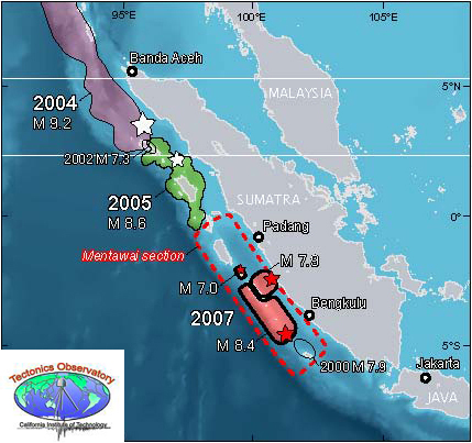
Although Alfred Wegener first began to present his ideas on Continental Drift in 1912 his publication in 1915 of The Origin of Continents and Oceans (Die Entstehung der Kontinente und Ozeane) is generally taken as the global launch of his hypothesis. Apart from support from Alexander du Toit and Arthur Holmes, geoluminaries of the day panned it unmercifully because, in the absence of evidence for a driving mechanism, he speculated that his proposed ‘urkontinent’ (primal continent) Pangaea had been split apart by a centrifugal mechanism connected to the precession of Earth’s rotational axis. This ‘polflucht’ (flight from the poles) is in fact far too weak to have any such influence. Wegener’s masterly assembly of geological evidence for former links between the major continents was ignored by the critics, suggesting that their motive for excoriation of his suggested mechanism was as much spite against an ‘outsider’ as a full consideration of his hypothesis. It must have been hurtful in the extreme, yet Wegener defended himself with a series of revised editions that amassed yet more concrete evidence. What is often overlooked, even now that his ideas have become part of the geoscientific canon, is that in his initial Geologische Rundschau paper in 1912 he mused that the floor of the Atlantic is continuously spreading by tearing apart at the mid-Atlantic Ridge where ‘relatively fluid and hot sima’ rises. Strangely, he dropped that idea in later works. Anyhow, neither 2012 nor 2015 was celebrated in the manner of the centenary-and-a-half of Darwin’s On the Origin of Species: 2009 was marked by palaeobiologists and geneticists metaphorically dancing in the streets, if not foaming at the mouth. There have been a few paragraphs, and some minor symposia about Wegener’s dragging geology out of the 18th century and into the 20th, but that’s about it. The best centenary item I have seen is by Marco Romano and Richard Cifelli (Romano, M. & Cifelli, R.L. 2015. 100 years of continental drift. Science, v. 350, p. 916-916).

In the shape of plate tectonics the Earth sciences hosted what was truly a revolution in science, albeit 50 years on from its discoverer’s announcement. It was through the persistent agitation by his tiny band of supporters, that the upheaval was unleashed when the revelations from palaeomagnetism, seismology and many other lines of evidence were resolved as plate tectonics by the discovery of ocean-floor magnetic stripes by Vine, Matthews and Morley in 1963. Despite an explosion of papers that followed, elaborating onthe new theory and showing examples of its influence on ‘big’ geology , counter-revolutionary resistance lasted almost to the first years of the new century. By then so much evidence had emerged from every geological Eon that opponents looked truly stupid. Even so, the skepticism among those sub-disciplines that were ‘left out’ of geodynamic thought continued to blurt out with the emergence of other exciting aspects of the Earth’s history. I remember that, when three of us in the Open University’s Department of Earth Sciences proposed in 1994 that the influence of impacts by extraterrestrial objects ought to figure in a new course on the evolution of Earth and Life we were sneered at as ‘whizz-bang kids’ by those more earth-bound. Trying belatedly in 1996 to introduce students to another revolutionary development – the use of sedimentary and glacial oxygen isotopes in unraveling past climate change – became a huge struggle in the OU’s Faculty of Science. It went to the press eventually and for 2 years our students had the benefit. But the murmuration of dissent ended with a force-majeur re-edit of the course, by someone who had played no role in its development, expunged the lot and changed the ‘offending’ section back to the way it had been a decade before.  As they say: ho hum!

Oddly, in the last 15 years or so of trying to follow in Earth-Pages what I considered to be the most exciting developments in the geosciences, it has become increasing difficult to find papers in the top journals that are truly ground-breaking. Of course that may just be ageing and a certain cynicism that often companies it. From being spoiled for choice week after week it has become increasingly difficult from month to month to maintain the standards that I have set for new work. Has Earth science entered the fifth phase of a ‘paradigm shift’ predicted by philosopher Thomas Kuhn in his 1962 book The Structure of Scientific Revolutions? According to him once a science has entered a period when there is little consensus on the theories that might lie at the root of natural processes there is a drift in opinion to a few conceptual frameworks that seem to work, albeit leaving a lot to be desired. Weaknesses at the frontier between theory and empirical knowledge become increasingly burdensome as a result of the steady plod of ‘normal science’ until the science in question reaches a crisis. If existing paradigms fail repeatedly, science is ripe for the metaphorical equivalent of a ‘Big Bang’: maybe an entirely new discovery or hypothesis, or an idea that has been suppressed which new data fits better than any others that have been common currency. Plate Tectonics is the second kind. After the revolution much is reexamined and new lines of work emerge, until in Kuhn’s 5th phase scientists return to ‘normal science’. That looks like a pretty good story, on paper, but other forces are at work in science; external to scientific objectives. Most of these are a blend of economics, political ideologies and managerial ‘practicalities’. If the Earth sciences have entered the doldrums of novelty, I suspect it is these forces that are bearing some kind of glum fruit.

The old concept of academic freedom has gone by the board. Institutions demand that research is externally funded – the more the better as the institution, at least in the UK, demands a kind of tax (40% of that proposed) supposedly to cover corporate overheads including salaries of support staff. If an academic doesn’t pull in the dosh, she is not much favoured. If the individual doesn’t publish regularly either, there is a weasel sanction: Josephine Soap is declared ‘research inactive’. Consortia of researchers are more and more in vogue: managers and funders like ‘team players’, so individuals who are bright and confident enough to ‘stick their necks out’ cannot do that in a consortium publication and as often as not are ‘left on the bench’. Risk taking is more dangerous now and to stay ‘research active’, and in many cases of non-tenured posts getting a salary, an individual, even a few like-minded colleagues have to publish 2 or 3 papers a year.

It’s worth mentioning that open access publishing is not just all the rage, it has become more or less compulsory. Of course, it has some benefits for scientists in less well-heeled countries, but there is a downside. You have to raise the cash demanded by journals for the privilege or potentially universal access – at least US$1000 a pop, depending on a journals Impact Factor, and that of course is an odiously essential corporate consideration – and having done that woe betide those who do not publish and spend it. Academic publishing is the most profitable sector of the trade, the more so as print is supplanted by electronic delivery – the 50 free reprints is a thing of the past. So there are more and more journals and each of them strives to get out more issues per year, and of course those have to be filled. To me, this all adds up to more and more ‘pot-boiler’ articles and a tendency to maximise the flesh rendered from the body of research work and into the pot. Taken together with the stresses of commodification in higher education and the now vertical corporate structures from which it is constituted, it shouldn’t be a surprise that excitement and inspiration are at a premium in the weekly and monthly output of such a marginal science as that concerned with how the world works.

Some cunning radiometric dating

At the end of the 1970’s I was invited by the Deputy Director of the Geological Survey of India (Southern Region) to participate in the Great Postal Symposium on the Cuddapah Basin: a sort of harbinger of the Internet and Skype, but using snail-mail. Feeling pretty honoured and most intrigued I accepted; not that I knew the first thing about the subject. A regular stream of foolscap mimeographed contributions kept me nipping out of my office to check my pigeon hole for about 6 months. I learned a lot, but felt unable to comment. Four years on I was taken across the Cuddapahs by my first research student – a budding moto-cross driver with a morbid fear of bullock carts – en route from the Archaean low-grade greenstone-granite terrains of Karnataka for a peek at the fabled charnockites near Chennai (then Madras). A bit of a round-about route but spurred by my memories of the Great Postal Symposium. Sadly, the detour was marred for me by a severe case of sciatica brought on by manic driving, the state of the trans-Cuddapah highway and a misplaced gamma-globulin shot to ward off several varieties of hepatitis: I mainly blamed the nurse who demanded that I drop my drawers and bravely take the huge needle in a buttock – they do these things more humanely these days. Anyhow, apart from seeing many dusty villages build of slates perfect enough to make a full-size snooker table, my mind was elsewhere and I have long regretted that.

Landsat image mosaic showing part of the Cuddapah Basin.

Hosting possibly the world’s only diamondiferous Precambrian conglomerate, the Cuddapah Basin contains a 5 km thickness of diverse sedimentary strata, but no tangible fossils. It rests unconformably on the Archaean greenstone-granite terrain of the Dharwar Craton and so is Proterozoic in age; an Eon that spans 2 billion years. The middle of the lowest sedimentary formations (the Papaghni and Chitravati Groups) contains volcanic rocks dated at ~1.9 Ga; another group is cut by a ~1.5 Ga granite, and hitherto the youngest dateable event is the emplacement of 1.1 Ga kimberlites that sourced the diamonds in the conglomerate. Until recently the stratigraphy has been known in some detail, but how to partition it in Proterozoic time is barely conceivable with just three dates in the middle parts that span 800 Ma. All that can be said about the base of the Cuddapah sediments is that they are younger than the 3.1 to 2.6 Ga Archaean rocks beneath. Since the uppermost beds are truncated by a huge thrust system that shoved deep crustal granulites over them their minimum age is equally vague.

Structurally, the Basin began to form on a stable continent underpinned by the Dharwar Craton, but when that collided with Enderbyland in Antarctica, as part of the accretion of the Gondwana supercontinent, sedimentation may have been in an entirely different setting. Indeed, some of the sediments have been carried over the undisturbed part of the basin by a major thrust system. To explore both sedimentary and tectonic evolution Australian, Indian and Canadian geoscientists combined to sample and radiometrically date the entire pile (Collins, A.S. and 13 others 2015. Detrital mineral age, radiogenic isotopic stratigraphy and tectonic significance of the Cuddapah Basin, India. Gondwana Research, v. 28, p. 1294-1309). By precisely dating detrital micas and zircons from the sediments the team was able to check the source region of sedimentary grains as well as to establish a maximum age for each major stratigraphic unit. This helped establish a 3-part sedimentary and tectonic history. The earliest sediments came from the cratonic area to the west, but there are signs that collisional orogeny between 1590 and 1659 Ma produced a new sedimentary source in metamorphic rocks forming to the east. A return to westward provenance marked the youngest sedimentary setting. This enabled the team to suggest a dual evolution of the Basin, first as an extensional rift opening at the east of what is now the Dharwar craton followed by collisional orogeny that transformed the setting to that of a foreland basin, analogous to the Molasse basin in front of the Alps during Cenozoic times, ending with tectonic inversion when extension changed to compression and thrusting.

But to what extent did the work improve the age subdivision of the Cuddapah Basin? Apparently very little, which may be down to a problem with dating detrital minerals. If magmatic and metamorphic evolution was continuous in the areas from which sediments moved, then the youngest grain is a good guide to the maximum age of the sediment being analysed. The more strata are analysed in this way the better the detail of sedimentary timing. But two tectonic terrains are unlikely to produce zircons time and time again during a period approaching a billion years. The data indicate only 3 or 4 episodes of ‘zirconogenesis’ in the sedimentary hinterlands, between about 900 to 1940 Ma. Apart from helping correlate sedimentary formations that were previously deemed stratigraphically different – which did help in tectonically unravelling this complex major feature – several hundred isotopic analyses of zircons and micas have give much the same timing as was known already in more precise terms from stratigraphy assisted by a few dozen conventional radiometric dates.

Seismic menace of the Sumatra plate boundary

More than a decade after the 26 December 2004 Great Aceh Earthquake and the Indian Ocean tsunamis that devastating experience and four more lesser seismic events (> 7.8 Magnitude) have show a stepwise shift in activity to the SE along the Sumatran plate boundary. It seems that stresses along the huge thrust system associated with subduction of the Indo-Australian Plate that had built up over 200 years of little seismicity are becoming unlocked from sector to sector along the Sumatran coast. Areas further to the SE are therefore at risk from both major earthquakes and tsunamis. A seismic warning system now operates in the Indian Ocean, but the effectiveness of communications to potential victims has been questioned since its installation. However, increasing sophistication of geophysical data and modelling allows likely zones at high risk to be assessed.

Recent Great Earthquakes in different segments of the Sumatra plate margin (credit: Tectonics Observatory, California Institute of Technology http://www.tectonics.caltech.edu/outreach/highlights/sumatra/why.html

One segment is known to have experienced giant earthquakes in 1797 and 1833 but none since then. What is known as the Mentawai seismic gap lies between two other segments in which large earthquakes have occurred in the 21st century: it is feared that gap will eventually be filled by another devastating event. Geophysicists from the Institut de Physique du Globe de Paris and Nanyang Technological University in Singapore have published a high-resolution seismic reflection survey showing the subduction zone beneath the Mentawai seismic gap (Kuncoro, A.K. et al. 2015. Tsunamigenic potential due to frontal rupturing in the Sumatra locked zone. Earth and Planetary Science Letters, v. 432, p. 311-322). It shows that that the upper part of the zone, the accretionary wedge, is laced with small thrust-bounded ‘pop-ups’. The base of the accretionary wedge shows a series of small seaward thrusts above the subduction surface itself forming ‘piggyback’ or duplex structures.

Seismic reflection profile across part of the Sumatra plate boundary, showing structures produced by past seismicity. (credit: Kuncoro et al. 2015, Figure 3b)

The authors model the mechanisms that probably produced these intricate structures. This shows that the inactive parts of the plate margin have probably locked in stresses equivalent to of the order of 10 m of horizontal displacement formed by the average 5 to 6 cm of annual subduction of the Indo-Australian Plate over the two centuries since the last major earthquakes. Reactivation of the local structures by release of this strain would distribute it by horizontal movements of between 5.5 to 9.2 m and related 2 to 6.6 m vertical displacement in the pop-ups. That may suddenly push up the seafloor substantially during a major earthquake, thereby producing tsunamis. Whether or not this is a special feature of the Sumatra plate boundary that makes it unusually prone to tsunami production is not certain: such highly resolving seismic profiles need to be conducted over all major subduction zones to resolve that issue. What does emerge from the study is that a repeat of the 2004 Indian Ocean tsunamis is a distinct possibility, sooner rather than later.

The core’s influence on geology: how does it do it?

Although no one can be sure about the details of processes in the Earth’s core what is accepted by all is that changes in core dynamics cause the geomagnetic field to change in strength and polarity, probably through some kind of physical interaction between core and deep mantle at the core-mantle boundary (CMB). Throughout the last 73 Ma and especially during the Cenozoic Era geomagnetism has been more fickle than at any time since a more or less continuous record began to be preserved in the Jurassic to Recent magnetic ‘stripes’ of the world ocean floor. Moreover, they came in bursts: 5 in a million years at around 72 Ma; 10 in 4 Ma centred on 54 Ma; 17 over 3 Ma around 42 Ma; 13 in 3 Ma at ~24 Ma; 51 over a period of 12 Ma centring on 15 Ma. During the Late Jurassic and Early Cretaceous the core was similarly ‘busy’, the two time spans of frequent reversals being preceded by quiet ‘superchrons’ dominated by the same normal polarity as we have today i.e. magnetic north being roughly around the north geographic pole.

The Cenozoic history of magnetic reversals - black periods were when geomagnetic field polarity was normal and white when reversed. (credit: Wikipedia)
The Cenozoic history of magnetic reversals – black periods were when geomagnetic field polarity was normal and white when reversed. (credit: Wikipedia)

Until recently geomagnetic ‘flips’ between the two superchrons were regarded as random , perhaps suggesting chaotic behaviour at the CMB. But such a view depends on the statistical method used. A novel approach to calculating reversal frequency through time, however, shows peak-trough pairs recurring 5 times through the Cenozoic Era, approximately 13 Ma apart: maybe the chaos is illusory (Chane, J. et al. 2015. The 13 million year Cenozoic pulse of the Earth. Earth and Planetary Science Letters, v. 431, p. 256-263). So, here is a kind of yardstick to see if there may be any connection between core processes and those at the surface, which Chen of the Fujian Normal University, Fushou China and Canadian and Chinese colleagues compared with the very detailed Cenozoic oxygen-isotope (δ18O) record preserved by foraminifera in ocean-floor sediments, which is a well established proxy for changes in climate. Removing the broad trend of cooling through the Cenozoic resulted in a plot of more intricate climatic shifts that matches the geomagnetism record in both shape and timing of peak-trough pairs. It also turns out, or so the authors claim, that both measures correlate with changes in the rate of Cenozoic subduction of oceanic lithosphere (a measure of plate tectonic activity), albeit negative – peaks in magnetism and climate connecting with slowing in the pace of tectonics.

The analyses involved some complicated maths, but taken at face value the correlations beg the questions why and how? Long-term climate change contains an astronomical signal, encapsulated in the Milankovich hypothesis which has been tested again and again with little room for refutation. So is this all to do with gravitational influences in the Solar System. More exotic still is the possibility of 13 Ma cyclicity linking the Milankovich mechanism with the vaster scale of the Sun’s orbit oscillating through the disc of the Milky Way galaxy and theoretical hints of a mysterious role for dark matter in or near the galaxy. Or, is it a relationship in which climate and the magnetic field are modulated by plate tectonics through varying volcanic emissions of greenhouse gases and the deep effect of subduction on processes at the CMB respectively? To me that seems more plausible, but it is still as exceedingly complex as the maths used to reveal the correlations.

Fascinating glacial feature found on Mars

Many of the vast wastes of northern Canada and Scandinavia that were ground to a paste by ice sheets during the last glacial cycle show peculiar features that buck the general glacial striation of the Shield rocks. They are round-topped ridges that wind apparently aimlessly across the tundra. In what is now a gigantic morass, the ridges form well-drained migration routes for caribou and became favourite hunting spots for the native hunter gatherers: in Canada they are dotted with crude simulations of the human form, or inugoks, that the Innuit erected to corral game to killing grounds. Where eroded they prove to be made of sand and gravel, which has proved an economic resource in some areas lacking in building aggregate, good but small examples being found in the Scottish Midland Valley that have served development of Glasgow and Edinburgh. They were given the Gaelic name eiscir meaning ‘ridge of gravel’ (now esker) from a few examples in Ireland.

Eskers form from glacial meltwater that makes its way from surface chasms known as moulins to the very bottom of an ice sheet where water flows much in the manner of a river, except in tubes rather than channels. Where the ice base is more or less flat the tubes meander as do normal sluggish rivers, and like them the tubes deposit a proportion of the abundant sediment derived by melting glacial ice. Once the ice sheet melts and ablates away, the sediments lose the support of the tube walls and flop down to form the eponymous low ridges: the reverse of the sediment filled channels of streams that have either dried up or migrated. Eskers are one of the features that shout ‘glacial action’ with little room for prevarication.

The classic form of eskers in the Phlegra Montes  of Mars. (credit:  Figure 6 in Gallagher and Balme, 2015)
The classic form of eskers in the Phlegra Montes of Mars. (credit: Figure 6 in Gallagher and Balme, 2015)

Glacial terrains on Mars have been proposed for some odd looking surfaces, but other processes such as debris flows are equally attractive. To the astonishment of many, Martian eskers have now been spotted during systematic interpretation of the monumental archives of high-resolution orbital images of the planetary surface (Gallagher, C. & Balme, M. 2015. Eskers in a complete, wet-based glacial system in the Phlegra Montes region, Mars. Earth and Planetary Science Letters, v. 431, p. 96-109). The discovery is in a suspected glacial terrain that exhibits signs of something viscous having flowed on low ground around higher topographic features, bombardment stratigraphy suggests a remarkable young age for the terrain or about 150 Ma ago: the Amazonian. Ice and its effects are not too strange to suggest for Mars which today is pretty much frigid, except for a few suggestions of active flow of small watery streams. Eskers demand meltwater in abundance, and Gallagher and Balme attribute some of the other features in the Phlegra Montes to wet conditions. However, the eskers are a one-off, so far as they know. Consequently, rather than appealing to some climatic warm up to explain the evidence for wetness, they suggest that the flowing water tubes resulted from melting deep in the ice as a result of locally high heat flow through the Martian crust, which is a lot more plausible.

Surprising modern-human migrations into China and Africa

Caves figure highly in discoveries of hominin remains, fossil riches from those near Johannesburg in South Africa and at Atapuerca in northern Spain having set the world of palaeoanthropology reeling in the last few months. As often as not the caves chosen by hominins for day-to-day living, refuge or ritual, places where carnivores dragged some of our early relatives, or into which they fell accidentally, formed in limestones. There are few places so well endowed with karst features than southern China, a fair number of caves in them having rich deposits of bat guano to which farmers have beaten well-trodden paths to dig it out for fertiliser. One such is Fuyan Cave in Daoxian County, Hunan. Manure mining there had done a great deal of the heavy work faced by archaeologists, having stopped when it reached a hard layer of calcite speleothem or flowstone that underpaves more or less the entire cave floor. Initial trial investigations found three clearly human teeth at the surface, encouraging further work. Digging through the flowstone revealed sediments rich in fossils, mainly teeth which preserve better than other remains in humid conditions. As well as teeth from a variety of mammals, large and small, 47 human teeth emerged. Close study revealed dental features that are irrefutably those of anatomically modern humans (Liu, W. and 13 others 2015. The earliest unequivocally modern humans in southern China. Nature, doi:10.1038/nature15696). Remarkably, many of the teeth are in far better condition than my own, and those of many living people with access to dental expertise.

Some of the Daoxian human teeth. (Credit: Song Xing and Xiu-jie Wu of the 1Key Laboratory of Vertebrate Evolution and Human Origins at the Chinese Academy of Sciences
Some of the Daoxian human teeth. (Credit: Song Xing and Xiu-jie Wu of the 1Key Laboratory of Vertebrate Evolution and Human Origins at the Chinese Academy of Sciences)

The true significance of the excavation emerged only when 230Th dating revealed the age of the flowstone cap to the old cave sediments. A small stalagmite protruding from its surface yielded a minimum age of ~80 ka: by far the oldest date for anatomically modern human remains outside of Africa and the eastern Mediterranean. The dating produced older ages around 120 ka with equally good precision. Before this discovery the date of migration of Africans to populate Eurasia was thought to be about 60 ka from imprecise dating based on genetics of a range of living Eurasians and Africans – a ‘molecular clock’ – and the earliest sign of humans found in Australia. Consequently, finds in South India of artefacts beneath 74 ka ash from the super-eruption of the Mount Toba caldera have been regarded by many, other than the finders, as having been made by Homo erectus. Dates of 100 ka for modern human occupation of the Levant were thought to represent a failed attempt at migration out of Africa by a northern route. Both these important findings now take on renewed significance. Yet a 30 to 40 ka time gap between the Fuyan people and the previous dates for the earliest signs of migration into China, Borneo and Australia (40-50 ka) begs the question, ‘Did this early group of far-travelled migrants survive to become ancestors of modern Chinese people?’ There are many possible scenarios that only future discoveries might validate: simply goiung extinct; failure to survive the encounter with earlier migrants, such as H. erectus or the Denisovans; assimilation into those older populations.

Mitochondrial DNA-based chart of large human m...
Mitochondrial DNA-based chart of large human migrations: the consensus before these new data. Numbers are millennia before present. ( credit: Wikipedia)

As if to counter this, a multinational group of collaborators have sequenced and analysed the genome from a 4500 year-old male skeleton discovered in the Mota Cave of the Gamo highlands of southern Ethiopia (Llorente, M.G. and 18 others 2015. Ancient Ethiopian genome reveals extensive Eurasian admixture throughout the African continent. Science, DOI: 10.1126/science.aad2879). Comparison with what is now a virtual library of living human genomes showed that this man’s genetic make-up most closely matched that of the Ari, a tribe living in the area today. What was most interesting is that part of the modern Ari genome – between 4 to 7% – is not present in the 4500 year-old sequence. Instead, it matches those of modern Sardinians and a prehistoric German farmer. Yet it occurs in people living not only in Ethiopia, but also in central, western and southern Africa to varying degrees. There seems to have been a ‘backflow’ of people into the whole of Africa from Eurasia, estimated to have occurred some 3500-4000 years ago and probably involving a large influx. By that time farming was already established in Africa, so the migrants may have had some advantage, either culturally or physically, to encourage their wide spread through the continent.

In tropical climates, DNA is likely to break down quickly and little if any fossil DNA has been recovered from prehistoric Africans. In this case, burial in a cave at high elevation may have helped preserve it, but also the target for extraction was the petrous bone from the inner ear whose density seems to allow DNA a better change of long-term survival. With continually improving DNA analysis and sequencing techniques more news is surely going to emerge from past African populations.

More on human migrations

Related articles

Gibbons, A. 2015. Prehistoric Eurasians streamed into Africa, genome shows. Science, v. 350 (9 October 2015), p. 149.

Deccan Trap sprung by bolide?

English: Alvarez and K-T Boundary
Luis and Walter Alvarez at the end-Mesozoic Boundary (credit: Wikipedia)

It was 35 years back that father and son team Luis and Walter Alvarez upset a great many geoscientists by suggesting that a very thin layer of iridium-rich mud that contained glass spherules and shocked mineral grains was evidence for a large meteorite having struck Earth. They especially annoyed palaeontologists because of their claim that it occurred at the very top of the youngest Cretaceous and that the mud was spread far and wide in deep- and shallow-marine stratigraphic sequences and also in those of continental rocks. It marked the boundary between the Mesozoic and Cenozoic Eras and, of course, the demise of the dinosaurs and a great many more, less ‘sexy’ beasts. Luis was a physicist, his son a proper geologist and their co-researchers were chemists. It can hardly be said that they stole anyone’s thunder since the issue of mass extinctions was quiescent, yet their discovery ranks with that of Alfred Wegener; another interloper into the closed-shop geoscientific community. They got the same cold-shoulder treatment, but massive popular acclaim as well, even from a minority of geologists who welcomed their having shaken up their colleagues, 15 years after the last ‘big thing’: plate tectonics. And then the actual site of the impact was found by geophysicists in a sedimentary basin in the Gulf of Mexico off the small town of Chicxulub on the Yucatan peninsula.

Chicxulub impact - artist impression
Chicxulub impact – artist impression (credit: Wikipedia)

As they say, ‘the rest is history’ and a great many geoscientists didn’t just jump but pounced on this potential bandwagon. Central to this activity was the fact that, within error, the ages of the impact, the mass extinction and a vast pile of continental lavas in western India, the Deccan Traps, were more or less the same (around 66 Ma). Flood basalt events are just about as dramatic as mega-impacts because of their sheer scale, of the order of a million cubic kilometres; that they were exuded in a mere million years or so, but in only a few tens of stupendous lava flows; and they are far beyond the direct experience of humans, blurting out only every 30 Ma or so. This periodicity roughly tallies with mass extinctions, great and small, through the Mesozoic. There have been two large bands of enthusiasts engaged in the causality of the end-Mesozoic die-off – the extraterrestrials and the parochialists who favoured a more mundane, albeit cataclysmic snuffing-out. Mass extinctions in general have been repeatedly examined, and in recent years it has become clear that most of those since 250 Ma ago seem to be associated with basalt-flood events and are purely terrestrial in origin. As regards the event that ended the Mesozoic, it has proved difficult to resolve whether to point the finger at the Deccan Traps or the Chicxulub impact. Both might have severely damaged the biosphere in perhaps different ways, so a ‘double whammy’ has become a compromise solution.

The Western Ghat hills at Matheran in Maharash...
Deccan flood basalts forming the Western Ghats in Maharashtra, India (credit: Wikipedia)

Unsurprisingly, a lot of effort from different quarters has gone into charting the progress of the Deccan volcanism. Some dating seemed at one stage to place the bulk of the volcanism significantly before the mass extinction and impact, others had them spot on and there were even signs of an hiatus in eruptions at the critical juncture. The problem was geochronological precision of the argon-argon method of radiometric dating that is most used for rocks of basaltic composition: many labs cannot do better than an uncertainty of 1%, which is ±0.7 Ma for ages around the end of the Mesozoic, not far short of the entire duration of these huge events. Some Deccan samples have now been dated to a standard of ±0.1 Ma by the Ar-Ar lab at the Department of Earth and Planetary Sciences, University of California-Berkeley (Renne, P.R. et al. 2010. State shift in Deccan volcanism at the Cretaceous-Paleogene boundary, possibly induced by impact. Science, v. 350, p. 76-78). The results, between 65.5 to 66.5 Ma, nicely bracket the K/T (now K/Pg) boundary age of 66.04±0.04 Ma. It looks like the double whammy compromise is the hypothesis of choice. But there is more to mere dating.

Renne and colleagues plot the ages against their position in the volcanic stratigraphy of the Deccan Traps in two ways: against the estimated height from base in the pile and against the estimated volume of the erupted materials as it built up – the extent and thickness of successive flows varies quite a lot. The second plot provided a surprise. After the K/Pg event the mean rate of effusion – the limited number of individual flows capped by well-developed soils shows that the build-up was episodic – doubled from 0.4±0.2 to 0.9±0.3 km3 yr-1. Despite the much larger uncertainty in the extent and volume of individual lava Formations than that of their ages, this is clearly significant. Does it imply that the Chicxulub impact somehow affected the magma production from, the mantle plume beneath the Deccan? It had been suggested early in the debate that the antipodean position of the lava field relative to that of Chicxulub may indicate that the huge seismicity from the impact triggered the Deccan magma production. Few accepted that possibility when it first appeared. However, Renne and co. do think it deserves another look, at least at the possibility of some linked effect on the magmatism. Perhaps the magma chamber was somehow enlarged by increased global seismicity; other chambers could have been added; magma might have been ‘pumped’ out more efficiently, or a combination of such effects. The ‘plumbing’ of flood basalt piles is generally hidden, but huge dyke swarms in Precambrian times have been suggested as feeders to long-eroded flood basalts. Seismicity of the scale produced by asteroid impacts can do a lot of damage. The Chicxulub impactor at around 10 km diameter would have carried energy a million times greater than that of the largest thermonuclear bomb, equivalent to an earthquake of Magnitude 12.4 that would have been a thousand times more powerful than the largest recorded earthquake with tectonic causes. Extensional faulting sourced in this fashion in the Deccan area may have increased the pathways along which magma might blurt out.

Duncan, R. 2015. Deadly combination. Nature, v. 527, p. 172-173.

Our ancestors parted from other humans earlier than expected

Despite the excitement raised by the discovery of remnants of 15 individuals of Homo naledi in a South African Cave the richest trove of hominin fossils remains that of Sima de los Huesos (‘pit of bones’) in northern Spain. In 2013 bone found in that cave from one of 28 or more individuals of what previous had been regarded as H. heidelbergensis, dated at around 400 ka, yielded mitochondrial DNA. It turned out to have affinities with mtDNA of both Neanderthals and Denisovans, especially the second. The data served to further complicate the issue of our origins, but were insufficient to do more than throw some doubt on the significance of H. heidelbergensis as a distinct species: nuclear DNA would do better, it was hoped by the palaeo-geneticists of the Max Planck Institute for Evolutionary Anthropology in Leipzig. Now a small fragment of those data (about 1 tro 2 million base pairs) have been presented to a London meeting of the European Society for the Study of Human Evolution – though not yet in a peer-reviewed journal. Anne Gibbons summarised the formal presentation in the 18 September 2015 issue of Science (Gibbons, Ann 2015. Humanity’s long, lonely road. Science, v. 349, p. 1270).

English: Cranium 5 is one of the most importan...
One of the best preserved discoveries in the Sima de los Huesos, Atapuerca (Spain). (credit: Wikipedia)

The partial nuclear DNA is a great deal more like that of Neanderthals from much more recent times than it is of either Denisovans and modern humans. It seems most likely that the Sima de los Huesos individuals are early Neanderthals, which implies that the Neanderthal-Denisovan split was earlier than 400 ka. That might seem to be just fine, except for one thing: Neanderthal and Denisovan DNA are much more closely related to each other than to that of ourselves. That implies that the last common ancestor of the two archaic human species must have split from the ancestral line leading to modern humans even further back in time: maybe 550 to 765 ka ago and 100 to 400 ka earlier than previously surmised. This opens up several interesting possibilities for our long and separate development. Since Neanderthals and perhaps Denisovans emigrated from Africa to Eurasia several glacial cycles ago, maybe people genetically en route to anatomically modern humans did so too. The Neanderthal and Denisovan genomes suggest that they interbred with each other and that could have been at any time after the genetic split between them. Famously, they also interbred with direct ancestors of living Eurasians, but there is no genetic sign of that among living Africans. The evidence suggests that the insertion of archaic genetic material was into new migrants from Africa around 100 to 60 ka ago at different points along their routes to Europe and East Asia. But, obviously, it is by no means clear cut what passed between all three long-lived groups nor when. It is now just as possible that surviving, earlier Eurasians on the road to modern humans passed on their own inheritance from relationships with Neanderthal and Denisovan to newcomers from Africa. But none of these three genetic groups ever made their way back to Africa, until historic times.

More on Neanderthals, Denisovans and anatomically modern humans

Continental hot-spot track in eastern Australia

cosgrove volcano track shown on map of australia
The Cosgrove volcanic track on a natural-colour image mosaic of Australia (credit: Drew Whitehouse, NCI National Facility VizLab)

It is sometimes forgotten that not only oceanic lithosphere provides evidence for hot spot tracks, probably because they are so obvious as island and seamount chains on bathymetric maps. They are not so clear on continents, either because of erosion of volcanoes or topography dominated by features that predate volcanism, but they account for about 20% of proposed tracks. Eastern Australia seems well endowed; four of them marked by a variety of volcanic structures that trend parallel to the Indo-Australian Plate’s NNE Cenozoic drift powered by the Southeast Indian Ridge that separates it from the Antarctic Plate. The timing of the volcanism along the proposed tracks is also highly persuasive. The longest of the tracks, extending about 2000 km SSW from Cape Hillsborough on the coast of central Queensland through New South Wales to Cosgrove in Victoria, is marked by sporadic volcanoes whose age decreases from Late Eocene in the north to Late Miocene in Victoria.

Unlike oceanic hot-spot tracks, those on continents are not continuous lines of volcanic occurrences. The Cosgrove track has several volcanic gaps, up to 650 km wide. This kind of patchy feature once encouraged hot-spot sceptics to question the tectonic affinities of what they regarded as fortuitous alignments. Where volcanic age trends consistent with the hypothesis emerged such doubts have faded into the background academic ‘noise’. In the case of the Cosgrove track all but one of the dates of volcanism tally quite well with the Cenozoic absolute motion of the Indo-Australian Plate and their position along the track (Davies, D.R. et al 2015. Lithospheric controls on magma composition along Earth’s longest continental hotspot track. Nature, v. 525, p. 511-514). Yet the objective of the authors, from the Australian National University and the University of Aberdeen in Britain, was not merely to establish the alignment as a hot-spot track, but to suggest what may have resulted in its marked patchiness.

The geochemistry of lavas from the volcanoes turns out to be of two fundamentally different types: ‘common-or-garden’ basalts in the case of Queensland and peculiar potassium-rich basalts containing the K-feldspathoid leucite in New South Wales and Victoria. Why these compositional differences occur where they do emerged very clearly when their positions were plotted on a new map of the thickness variations of the eastern Australian continental lithosphere. The ordinary basalts rest on the thinnest lithosphere (£110 km), whereas the leucitites are underlain by considerably thicker lithosphere (~135 km). This suggests that the rising mantle whose partial melting produced the magmas was halted at different depths, different geochemical ‘signatures’ of basalts depending on the pressure of melting. The most interesting outcome, albeit one based on an absence of evidence, is that the very large volcanic gaps along the track are each above much thicker lithosphere (>150 km). At those depths a rising mantle plume would be much less likely to begin melting.