Seismic menace of the Sumatra plate boundary

More than a decade after the 26 December 2004 Great Aceh Earthquake and the Indian Ocean tsunamis that devastating experience and four more lesser seismic events (> 7.8 Magnitude) have show a stepwise shift in activity to the SE along the Sumatran plate boundary. It seems that stresses along the huge thrust system associated with subduction of the Indo-Australian Plate that had built up over 200 years of little seismicity are becoming unlocked from sector to sector along the Sumatran coast. Areas further to the SE are therefore at risk from both major earthquakes and tsunamis. A seismic warning system now operates in the Indian Ocean, but the effectiveness of communications to potential victims has been questioned since its installation. However, increasing sophistication of geophysical data and modelling allows likely zones at high risk to be assessed.

Recent Great Earthquakes in different segments of the Sumatra plate margin (credit: Tectonics Observatory, California Institute of Technology http://www.tectonics.caltech.edu/outreach/highlights/sumatra/why.html

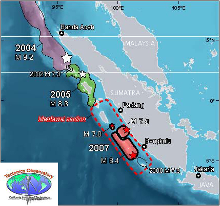
One segment is known to have experienced giant earthquakes in 1797 and 1833 but none since then. What is known as the Mentawai seismic gap lies between two other segments in which large earthquakes have occurred in the 21st century: it is feared that gap will eventually be filled by another devastating event. Geophysicists from the Institut de Physique du Globe de Paris and Nanyang Technological University in Singapore have published a high-resolution seismic reflection survey showing the subduction zone beneath the Mentawai seismic gap (Kuncoro, A.K. et al. 2015. Tsunamigenic potential due to frontal rupturing in the Sumatra locked zone. Earth and Planetary Science Letters, v. 432, p. 311-322). It shows that that the upper part of the zone, the accretionary wedge, is laced with small thrust-bounded ‘pop-ups’. The base of the accretionary wedge shows a series of small seaward thrusts above the subduction surface itself forming ‘piggyback’ or duplex structures.

Seismic reflection profile across part of the Sumatra plate boundary, showing structures produced by past seismicity. (credit: Kuncoro et al. 2015, Figure 3b)

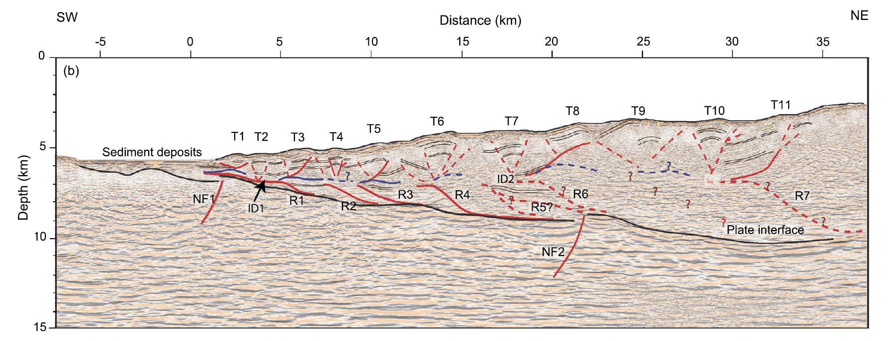
The authors model the mechanisms that probably produced these intricate structures. This shows that the inactive parts of the plate margin have probably locked in stresses equivalent to of the order of 10 m of horizontal displacement formed by the average 5 to 6 cm of annual subduction of the Indo-Australian Plate over the two centuries since the last major earthquakes. Reactivation of the local structures by release of this strain would distribute it by horizontal movements of between 5.5 to 9.2 m and related 2 to 6.6 m vertical displacement in the pop-ups. That may suddenly push up the seafloor substantially during a major earthquake, thereby producing tsunamis. Whether or not this is a special feature of the Sumatra plate boundary that makes it unusually prone to tsunami production is not certain: such highly resolving seismic profiles need to be conducted over all major subduction zones to resolve that issue. What does emerge from the study is that a repeat of the 2004 Indian Ocean tsunamis is a distinct possibility, sooner rather than later.

Assessing submarine great-earthquake statistics fails

Geologists who study turbidites assume that the distinctive graded beds from which they are constructed and a range of other textures represent flows of slurry down unstable steep slopes when submarine sediment deposits are displaced. Such turbidity currents were famously recorded by the severing of 12 transatlantic telecommunication cables off Newfoundland in 1929. This happened soon after an earthquake triggered 100 km hr-1 flows down the continental slope, which swept some 600 km eastwards.

Load structures on turbidite sandstones, Crook...
Typical structures in Upper Carboniferous turbidites near Bude, Cornwall, UK (credit: Flickr, Earthwatcher)

Sea beds at destructive margins provide the right conditions for repeated turbidity currents and it is reasonable to suppose that patterns should emerge from the resulting turbidite beds that in some way record the seismic history of the area. British and Indonesian geoscientists set out to test that hypothesis at the now infamous plate margin off Sumatra that hosted the great Acheh Earthquake and tsunamis of 26 December 2004 to kill 250 thousand people around the rim of the Indian Ocean (Sumner, E.J. et al. 2013. Can turbidites be used to reconstruct a paleoearthquake record for the central Sumatra margin? Geology, v. 41, p.763-766).

Animation of 2004 Indonesia tsunami
Animation of Indonesian tsunami of 26 December 2004 (credit: Wikipedia)

Cores through turbidite sequences along a 500 km stretch of the margin formed the basis for this important attempt to test the possibility of recording long-term seismic statistics. To avoid false signals from turbidity currents stirred up by storms, floods and slope failure from rapid sediment build-up 17 sites were cored in deep water away from major terrestrial sediment supplies, which only flows triggered by major earthquakes would be likely to reach. To calibrate core depth to time involved a variety of radiometric  and stratigraphic methods

Disappointingly, few of the sites on the submarine slopes recorded turbidites that match events during the 150-year period of seismic records in the area, none being correlatable with the 2004 and 2005 great earthquakes. Indeed very little correlation of distinctive textures from site to site emerged from the study. Some sites on slopes revealed no turbidites at all from the last 150 years, whereas turbidites in others that could be accurately dated occurred when there were no large earthquakes. Only cores from the deep submarine trench consistently preserved near-surface turbidites that might record the 2004 and 2005 great earthquakes.

These are surprising as well as depressing results, but perhaps further coring will discover what kind of bathymetric features might yield useful and consistent seismic records from sediments.