Former Senior Lecturer at British Open University, research in remote sensing of arid lands, groundwater exploration, Precambrian tectonics and geochemistry
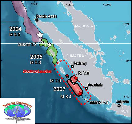
More than a decade after the 26 December 2004 Great Aceh Earthquake and the Indian Ocean tsunamis that devastating experience and four more lesser seismic events (> 7.8 Magnitude) have show a stepwise shift in activity to the SE along the Sumatran plate boundary. It seems that stresses along the huge thrust system associated with subduction of the Indo-Australian Plate that had built up over 200 years of little seismicity are becoming unlocked from sector to sector along the Sumatran coast. Areas further to the SE are therefore at risk from both major earthquakes and tsunamis. A seismic warning system now operates in the Indian Ocean, but the effectiveness of communications to potential victims has been questioned since its installation. However, increasing sophistication of geophysical data and modelling allows likely zones at high risk to be assessed.
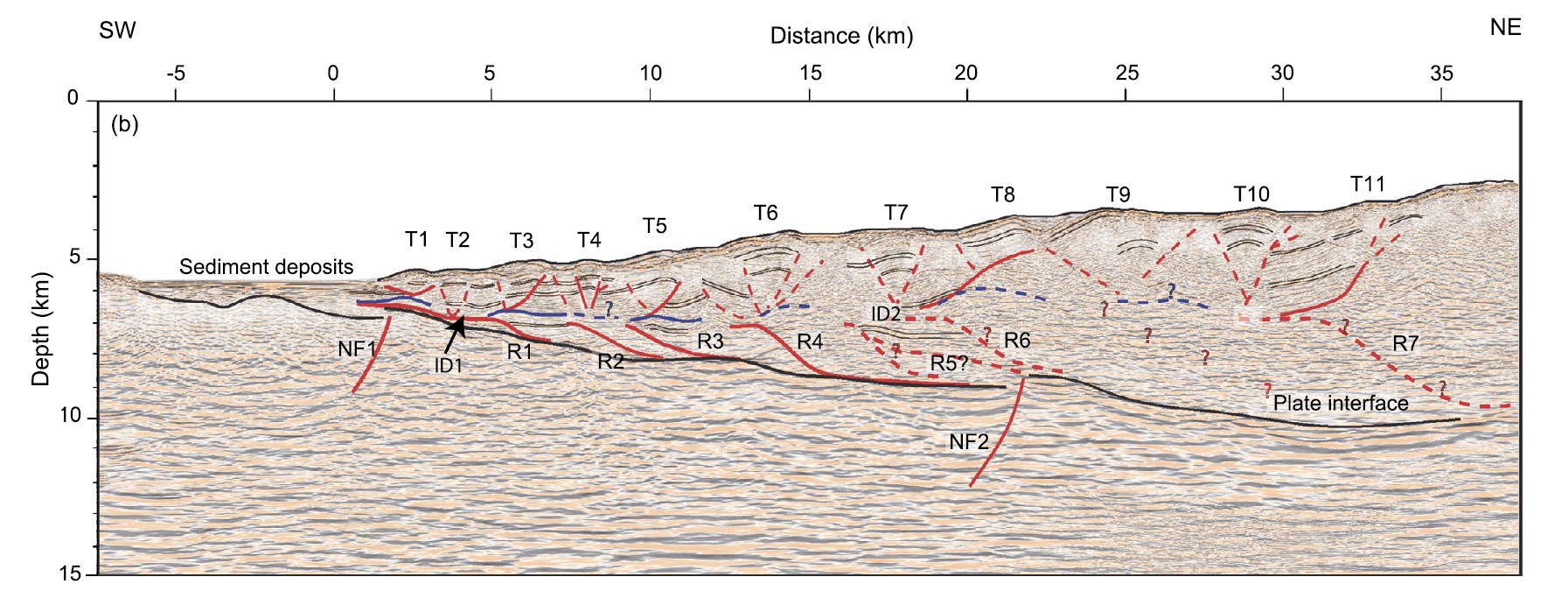
One segment is known to have experienced giant earthquakes in 1797 and 1833 but none since then. What is known as the Mentawai seismic gap lies between two other segments in which large earthquakes have occurred in the 21st century: it is feared that gap will eventually be filled by another devastating event. Geophysicists from the Institut de Physique du Globe de Paris and Nanyang Technological University in Singapore have published a high-resolution seismic reflection survey showing the subduction zone beneath the Mentawai seismic gap (Kuncoro, A.K. et al. 2015. Tsunamigenic potential due to frontal rupturing in the Sumatra locked zone. Earth and Planetary Science Letters, v. 432, p. 311-322). It shows that that the upper part of the zone, the accretionary wedge, is laced with small thrust-bounded ‘pop-ups’. The base of the accretionary wedge shows a series of small seaward thrusts above the subduction surface itself forming ‘piggyback’ or duplex structures.
Seismic reflection profile across part of the Sumatra plate boundary, showing structures produced by past seismicity. (credit: Kuncoro et al. 2015, Figure 3b)
The authors model the mechanisms that probably produced these intricate structures. This shows that the inactive parts of the plate margin have probably locked in stresses equivalent to of the order of 10 m of horizontal displacement formed by the average 5 to 6 cm of annual subduction of the Indo-Australian Plate over the two centuries since the last major earthquakes. Reactivation of the local structures by release of this strain would distribute it by horizontal movements of between 5.5 to 9.2 m and related 2 to 6.6 m vertical displacement in the pop-ups. That may suddenly push up the seafloor substantially during a major earthquake, thereby producing tsunamis. Whether or not this is a special feature of the Sumatra plate boundary that makes it unusually prone to tsunami production is not certain: such highly resolving seismic profiles need to be conducted over all major subduction zones to resolve that issue. What does emerge from the study is that a repeat of the 2004 Indian Ocean tsunamis is a distinct possibility, sooner rather than later.
Although no one can be sure about the details of processes in the Earth’s core what is accepted by all is that changes in core dynamics cause the geomagnetic field to change in strength and polarity, probably through some kind of physical interaction between core and deep mantle at the core-mantle boundary (CMB). Throughout the last 73 Ma and especially during the Cenozoic Era geomagnetism has been more fickle than at any time since a more or less continuous record began to be preserved in the Jurassic to Recent magnetic ‘stripes’ of the world ocean floor. Moreover, they came in bursts: 5 in a million years at around 72 Ma; 10 in 4 Ma centred on 54 Ma; 17 over 3 Ma around 42 Ma; 13 in 3 Ma at ~24 Ma; 51 over a period of 12 Ma centring on 15 Ma. During the Late Jurassic and Early Cretaceous the core was similarly ‘busy’, the two time spans of frequent reversals being preceded by quiet ‘superchrons’ dominated by the same normal polarity as we have today i.e. magnetic north being roughly around the north geographic pole.
The Cenozoic history of magnetic reversals – black periods were when geomagnetic field polarity was normal and white when reversed. (credit: Wikipedia)
Until recently geomagnetic ‘flips’ between the two superchrons were regarded as random , perhaps suggesting chaotic behaviour at the CMB. But such a view depends on the statistical method used. A novel approach to calculating reversal frequency through time, however, shows peak-trough pairs recurring 5 times through the Cenozoic Era, approximately 13 Ma apart: maybe the chaos is illusory (Chane, J. et al. 2015. The 13 million year Cenozoic pulse of the Earth. Earth and Planetary Science Letters, v. 431, p. 256-263). So, here is a kind of yardstick to see if there may be any connection between core processes and those at the surface, which Chen of the Fujian Normal University, Fushou China and Canadian and Chinese colleagues compared with the very detailed Cenozoic oxygen-isotope (δ18O) record preserved by foraminifera in ocean-floor sediments, which is a well established proxy for changes in climate. Removing the broad trend of cooling through the Cenozoic resulted in a plot of more intricate climatic shifts that matches the geomagnetism record in both shape and timing of peak-trough pairs. It also turns out, or so the authors claim, that both measures correlate with changes in the rate of Cenozoic subduction of oceanic lithosphere (a measure of plate tectonic activity), albeit negative – peaks in magnetism and climate connecting with slowing in the pace of tectonics.
The analyses involved some complicated maths, but taken at face value the correlations beg the questions why and how? Long-term climate change contains an astronomical signal, encapsulated in the Milankovich hypothesis which has been tested again and again with little room for refutation. So is this all to do with gravitational influences in the Solar System. More exotic still is the possibility of 13 Ma cyclicity linking the Milankovich mechanism with the vaster scale of the Sun’s orbit oscillating through the disc of the Milky Way galaxy and theoretical hints of a mysterious role for dark matter in or near the galaxy. Or, is it a relationship in which climate and the magnetic field are modulated by plate tectonics through varying volcanic emissions of greenhouse gases and the deep effect of subduction on processes at the CMB respectively? To me that seems more plausible, but it is still as exceedingly complex as the maths used to reveal the correlations.
Many of the vast wastes of northern Canada and Scandinavia that were ground to a paste by ice sheets during the last glacial cycle show peculiar features that buck the general glacial striation of the Shield rocks. They are round-topped ridges that wind apparently aimlessly across the tundra. In what is now a gigantic morass, the ridges form well-drained migration routes for caribou and became favourite hunting spots for the native hunter gatherers: in Canada they are dotted with crude simulations of the human form, or inugoks, that the Innuit erected to corral game to killing grounds. Where eroded they prove to be made of sand and gravel, which has proved an economic resource in some areas lacking in building aggregate, good but small examples being found in the Scottish Midland Valley that have served development of Glasgow and Edinburgh. They were given the Gaelic name eiscir meaning ‘ridge of gravel’ (now esker) from a few examples in Ireland.
Eskers form from glacial meltwater that makes its way from surface chasms known as moulins to the very bottom of an ice sheet where water flows much in the manner of a river, except in tubes rather than channels. Where the ice base is more or less flat the tubes meander as do normal sluggish rivers, and like them the tubes deposit a proportion of the abundant sediment derived by melting glacial ice. Once the ice sheet melts and ablates away, the sediments lose the support of the tube walls and flop down to form the eponymous low ridges: the reverse of the sediment filled channels of streams that have either dried up or migrated. Eskers are one of the features that shout ‘glacial action’ with little room for prevarication.
The classic form of eskers in the Phlegra Montes of Mars. (credit: Figure 6 in Gallagher and Balme, 2015)
Glacial terrains on Mars have been proposed for some odd looking surfaces, but other processes such as debris flows are equally attractive. To the astonishment of many, Martian eskers have now been spotted during systematic interpretation of the monumental archives of high-resolution orbital images of the planetary surface (Gallagher, C. & Balme, M. 2015. Eskers in a complete, wet-based glacial system in the Phlegra Montes region, Mars. Earth and Planetary Science Letters, v. 431, p. 96-109). The discovery is in a suspected glacial terrain that exhibits signs of something viscous having flowed on low ground around higher topographic features, bombardment stratigraphy suggests a remarkable young age for the terrain or about 150 Ma ago: the Amazonian. Ice and its effects are not too strange to suggest for Mars which today is pretty much frigid, except for a few suggestions of active flow of small watery streams. Eskers demand meltwater in abundance, and Gallagher and Balme attribute some of the other features in the Phlegra Montes to wet conditions. However, the eskers are a one-off, so far as they know. Consequently, rather than appealing to some climatic warm up to explain the evidence for wetness, they suggest that the flowing water tubes resulted from melting deep in the ice as a result of locally high heat flow through the Martian crust, which is a lot more plausible.
Caves figure highly in discoveries of hominin remains, fossil riches from those near Johannesburg in South Africa and at Atapuerca in northern Spain having set the world of palaeoanthropology reeling in the last few months. As often as not the caves chosen by hominins for day-to-day living, refuge or ritual, places where carnivores dragged some of our early relatives, or into which they fell accidentally, formed in limestones. There are few places so well endowed with karst features than southern China, a fair number of caves in them having rich deposits of bat guano to which farmers have beaten well-trodden paths to dig it out for fertiliser. One such is Fuyan Cave in Daoxian County, Hunan. Manure mining there had done a great deal of the heavy work faced by archaeologists, having stopped when it reached a hard layer of calcite speleothem or flowstone that underpaves more or less the entire cave floor. Initial trial investigations found three clearly human teeth at the surface, encouraging further work. Digging through the flowstone revealed sediments rich in fossils, mainly teeth which preserve better than other remains in humid conditions. As well as teeth from a variety of mammals, large and small, 47 human teeth emerged. Close study revealed dental features that are irrefutably those of anatomically modern humans (Liu, W. and 13 others 2015. The earliest unequivocally modern humans in southern China. Nature, doi:10.1038/nature15696). Remarkably, many of the teeth are in far better condition than my own, and those of many living people with access to dental expertise.
Some of the Daoxian human teeth. (Credit: Song Xing and Xiu-jie Wu of the 1Key Laboratory of Vertebrate Evolution and Human Origins at the Chinese Academy of Sciences)
The true significance of the excavation emerged only when 230Th dating revealed the age of the flowstone cap to the old cave sediments. A small stalagmite protruding from its surface yielded a minimum age of ~80 ka: by far the oldest date for anatomically modern human remains outside of Africa and the eastern Mediterranean. The dating produced older ages around 120 ka with equally good precision. Before this discovery the date of migration of Africans to populate Eurasia was thought to be about 60 ka from imprecise dating based on genetics of a range of living Eurasians and Africans – a ‘molecular clock’ – and the earliest sign of humans found in Australia. Consequently, finds in South India of artefacts beneath 74 ka ash from the super-eruption of the Mount Toba caldera have been regarded by many, other than the finders, as having been made by Homo erectus. Dates of 100 ka for modern human occupation of the Levant were thought to represent a failed attempt at migration out of Africa by a northern route. Both these important findings now take on renewed significance. Yet a 30 to 40 ka time gap between the Fuyan people and the previous dates for the earliest signs of migration into China, Borneo and Australia (40-50 ka) begs the question, ‘Did this early group of far-travelled migrants survive to become ancestors of modern Chinese people?’ There are many possible scenarios that only future discoveries might validate: simply goiung extinct; failure to survive the encounter with earlier migrants, such as H. erectus or the Denisovans; assimilation into those older populations.
Mitochondrial DNA-based chart of large human migrations: the consensus before these new data. Numbers are millennia before present. ( credit: Wikipedia)
As if to counter this, a multinational group of collaborators have sequenced and analysed the genome from a 4500 year-old male skeleton discovered in the Mota Cave of the Gamo highlands of southern Ethiopia (Llorente, M.G. and 18 others 2015. Ancient Ethiopian genome reveals extensive Eurasian admixture throughout the African continent. Science, DOI: 10.1126/science.aad2879). Comparison with what is now a virtual library of living human genomes showed that this man’s genetic make-up most closely matched that of the Ari, a tribe living in the area today. What was most interesting is that part of the modern Ari genome – between 4 to 7% – is not present in the 4500 year-old sequence. Instead, it matches those of modern Sardinians and a prehistoric German farmer. Yet it occurs in people living not only in Ethiopia, but also in central, western and southern Africa to varying degrees. There seems to have been a ‘backflow’ of people into the whole of Africa from Eurasia, estimated to have occurred some 3500-4000 years ago and probably involving a large influx. By that time farming was already established in Africa, so the migrants may have had some advantage, either culturally or physically, to encourage their wide spread through the continent.
In tropical climates, DNA is likely to break down quickly and little if any fossil DNA has been recovered from prehistoric Africans. In this case, burial in a cave at high elevation may have helped preserve it, but also the target for extraction was the petrous bone from the inner ear whose density seems to allow DNA a better change of long-term survival. With continually improving DNA analysis and sequencing techniques more news is surely going to emerge from past African populations.
Luis and Walter Alvarez at the end-Mesozoic Boundary (credit: Wikipedia)
It was 35 years back that father and son team Luis and Walter Alvarez upset a great many geoscientists by suggesting that a very thin layer of iridium-rich mud that contained glass spherules and shocked mineral grains was evidence for a large meteorite having struck Earth. They especially annoyed palaeontologists because of their claim that it occurred at the very top of the youngest Cretaceous and that the mud was spread far and wide in deep- and shallow-marine stratigraphic sequences and also in those of continental rocks. It marked the boundary between the Mesozoic and Cenozoic Eras and, of course, the demise of the dinosaurs and a great many more, less ‘sexy’ beasts. Luis was a physicist, his son a proper geologist and their co-researchers were chemists. It can hardly be said that they stole anyone’s thunder since the issue of mass extinctions was quiescent, yet their discovery ranks with that of Alfred Wegener; another interloper into the closed-shop geoscientific community. They got the same cold-shoulder treatment, but massive popular acclaim as well, even from a minority of geologists who welcomed their having shaken up their colleagues, 15 years after the last ‘big thing’: plate tectonics. And then the actual site of the impact was found by geophysicists in a sedimentary basin in the Gulf of Mexico off the small town of Chicxulub on the Yucatan peninsula.
Chicxulub impact – artist impression (credit: Wikipedia)
As they say, ‘the rest is history’ and a great many geoscientists didn’t just jump but pounced on this potential bandwagon. Central to this activity was the fact that, within error, the ages of the impact, the mass extinction and a vast pile of continental lavas in western India, the Deccan Traps, were more or less the same (around 66 Ma). Flood basalt events are just about as dramatic as mega-impacts because of their sheer scale, of the order of a million cubic kilometres; that they were exuded in a mere million years or so, but in only a few tens of stupendous lava flows; and they are far beyond the direct experience of humans, blurting out only every 30 Ma or so. This periodicity roughly tallies with mass extinctions, great and small, through the Mesozoic. There have been two large bands of enthusiasts engaged in the causality of the end-Mesozoic die-off – the extraterrestrials and the parochialists who favoured a more mundane, albeit cataclysmic snuffing-out. Mass extinctions in general have been repeatedly examined, and in recent years it has become clear that most of those since 250 Ma ago seem to be associated with basalt-flood events and are purely terrestrial in origin. As regards the event that ended the Mesozoic, it has proved difficult to resolve whether to point the finger at the Deccan Traps or the Chicxulub impact. Both might have severely damaged the biosphere in perhaps different ways, so a ‘double whammy’ has become a compromise solution.
Deccan flood basalts forming the Western Ghats in Maharashtra, India (credit: Wikipedia)
Unsurprisingly, a lot of effort from different quarters has gone into charting the progress of the Deccan volcanism. Some dating seemed at one stage to place the bulk of the volcanism significantly before the mass extinction and impact, others had them spot on and there were even signs of an hiatus in eruptions at the critical juncture. The problem was geochronological precision of the argon-argon method of radiometric dating that is most used for rocks of basaltic composition: many labs cannot do better than an uncertainty of 1%, which is ±0.7 Ma for ages around the end of the Mesozoic, not far short of the entire duration of these huge events. Some Deccan samples have now been dated to a standard of ±0.1 Ma by the Ar-Ar lab at the Department of Earth and Planetary Sciences, University of California-Berkeley (Renne, P.R. et al. 2010. State shift in Deccan volcanism at the Cretaceous-Paleogene boundary, possibly induced by impact. Science, v. 350, p. 76-78). The results, between 65.5 to 66.5 Ma, nicely bracket the K/T (now K/Pg) boundary age of 66.04±0.04 Ma. It looks like the double whammy compromise is the hypothesis of choice. But there is more to mere dating.
Renne and colleagues plot the ages against their position in the volcanic stratigraphy of the Deccan Traps in two ways: against the estimated height from base in the pile and against the estimated volume of the erupted materials as it built up – the extent and thickness of successive flows varies quite a lot. The second plot provided a surprise. After the K/Pg event the mean rate of effusion – the limited number of individual flows capped by well-developed soils shows that the build-up was episodic – doubled from 0.4±0.2 to 0.9±0.3 km3 yr-1. Despite the much larger uncertainty in the extent and volume of individual lava Formations than that of their ages, this is clearly significant. Does it imply that the Chicxulub impact somehow affected the magma production from, the mantle plume beneath the Deccan? It had been suggested early in the debate that the antipodean position of the lava field relative to that of Chicxulub may indicate that the huge seismicity from the impact triggered the Deccan magma production. Few accepted that possibility when it first appeared. However, Renne and co. do think it deserves another look, at least at the possibility of some linked effect on the magmatism. Perhaps the magma chamber was somehow enlarged by increased global seismicity; other chambers could have been added; magma might have been ‘pumped’ out more efficiently, or a combination of such effects. The ‘plumbing’ of flood basalt piles is generally hidden, but huge dyke swarms in Precambrian times have been suggested as feeders to long-eroded flood basalts. Seismicity of the scale produced by asteroid impacts can do a lot of damage. The Chicxulub impactor at around 10 km diameter would have carried energy a million times greater than that of the largest thermonuclear bomb, equivalent to an earthquake of Magnitude 12.4 that would have been a thousand times more powerful than the largest recorded earthquake with tectonic causes. Extensional faulting sourced in this fashion in the Deccan area may have increased the pathways along which magma might blurt out.
Related articles
Duncan, R. 2015. Deadly combination. Nature, v. 527, p. 172-173.
Despite the excitement raised by the discovery of remnants of 15 individuals of Homo naledi in a South African Cave the richest trove of hominin fossils remains that of Sima de los Huesos (‘pit of bones’) in northern Spain. In 2013 bone found in that cave from one of 28 or more individuals of what previous had been regarded as H. heidelbergensis, dated at around 400 ka, yielded mitochondrial DNA. It turned out to have affinities with mtDNA of both Neanderthals and Denisovans, especially the second. The data served to further complicate the issue of our origins, but were insufficient to do more than throw some doubt on the significance of H. heidelbergensis as a distinct species: nuclear DNA would do better, it was hoped by the palaeo-geneticists of the Max Planck Institute for Evolutionary Anthropology in Leipzig. Now a small fragment of those data (about 1 tro 2 million base pairs) have been presented to a London meeting of the European Society for the Study of Human Evolution – though not yet in a peer-reviewed journal. Anne Gibbons summarised the formal presentation in the 18 September 2015 issue of Science (Gibbons, Ann 2015. Humanity’s long, lonely road. Science, v. 349, p. 1270).
One of the best preserved discoveries in the Sima de los Huesos, Atapuerca (Spain). (credit: Wikipedia)
The partial nuclear DNA is a great deal more like that of Neanderthals from much more recent times than it is of either Denisovans and modern humans. It seems most likely that the Sima de los Huesos individuals are early Neanderthals, which implies that the Neanderthal-Denisovan split was earlier than 400 ka. That might seem to be just fine, except for one thing: Neanderthal and Denisovan DNA are much more closely related to each other than to that of ourselves. That implies that the last common ancestor of the two archaic human species must have split from the ancestral line leading to modern humans even further back in time: maybe 550 to 765 ka ago and 100 to 400 ka earlier than previously surmised. This opens up several interesting possibilities for our long and separate development. Since Neanderthals and perhaps Denisovans emigrated from Africa to Eurasia several glacial cycles ago, maybe people genetically en route to anatomically modern humans did so too. The Neanderthal and Denisovan genomes suggest that they interbred with each other and that could have been at any time after the genetic split between them. Famously, they also interbred with direct ancestors of living Eurasians, but there is no genetic sign of that among living Africans. The evidence suggests that the insertion of archaic genetic material was into new migrants from Africa around 100 to 60 ka ago at different points along their routes to Europe and East Asia. But, obviously, it is by no means clear cut what passed between all three long-lived groups nor when. It is now just as possible that surviving, earlier Eurasians on the road to modern humans passed on their own inheritance from relationships with Neanderthal and Denisovan to newcomers from Africa. But none of these three genetic groups ever made their way back to Africa, until historic times.
The Cosgrove volcanic track on a natural-colour image mosaic of Australia (credit: Drew Whitehouse, NCI National Facility VizLab)
It is sometimes forgotten that not only oceanic lithosphere provides evidence for hot spot tracks, probably because they are so obvious as island and seamount chains on bathymetric maps. They are not so clear on continents, either because of erosion of volcanoes or topography dominated by features that predate volcanism, but they account for about 20% of proposed tracks. Eastern Australia seems well endowed; four of them marked by a variety of volcanic structures that trend parallel to the Indo-Australian Plate’s NNE Cenozoic drift powered by the Southeast Indian Ridge that separates it from the Antarctic Plate. The timing of the volcanism along the proposed tracks is also highly persuasive. The longest of the tracks, extending about 2000 km SSW from Cape Hillsborough on the coast of central Queensland through New South Wales to Cosgrove in Victoria, is marked by sporadic volcanoes whose age decreases from Late Eocene in the north to Late Miocene in Victoria.
Unlike oceanic hot-spot tracks, those on continents are not continuous lines of volcanic occurrences. The Cosgrove track has several volcanic gaps, up to 650 km wide. This kind of patchy feature once encouraged hot-spot sceptics to question the tectonic affinities of what they regarded as fortuitous alignments. Where volcanic age trends consistent with the hypothesis emerged such doubts have faded into the background academic ‘noise’. In the case of the Cosgrove track all but one of the dates of volcanism tally quite well with the Cenozoic absolute motion of the Indo-Australian Plate and their position along the track (Davies, D.R. et al 2015. Lithospheric controls on magma composition along Earth’s longest continental hotspot track. Nature, v. 525, p. 511-514). Yet the objective of the authors, from the Australian National University and the University of Aberdeen in Britain, was not merely to establish the alignment as a hot-spot track, but to suggest what may have resulted in its marked patchiness.
The geochemistry of lavas from the volcanoes turns out to be of two fundamentally different types: ‘common-or-garden’ basalts in the case of Queensland and peculiar potassium-rich basalts containing the K-feldspathoid leucite in New South Wales and Victoria. Why these compositional differences occur where they do emerged very clearly when their positions were plotted on a new map of the thickness variations of the eastern Australian continental lithosphere. The ordinary basalts rest on the thinnest lithosphere (£110 km), whereas the leucitites are underlain by considerably thicker lithosphere (~135 km). This suggests that the rising mantle whose partial melting produced the magmas was halted at different depths, different geochemical ‘signatures’ of basalts depending on the pressure of melting. The most interesting outcome, albeit one based on an absence of evidence, is that the very large volcanic gaps along the track are each above much thicker lithosphere (>150 km). At those depths a rising mantle plume would be much less likely to begin melting.
The week of 7 to 11 September 2015 was one of the most news-rich of the year. To name but two issues: the plight of tens of thousands of refugees fleeing Africa and the Middle East to Europe was made worse by total confusion, little action and downright obstruction by some of the most privileged governments on Earth ; in Britain one of the most exciting political dramas in decades – the leadership elections of the Labour Party – were reaching a climax of press and political skulduggery because of the unexpected direction both had taken. Something else burst onto the media scene that was, if anything, even more out-of-the-blue to the majority of people on Thursday 10 September: the remains of at least 15 individuals of a new hominin species found in a near-inaccessible cave were announced by a multinational team of geologists and anthropologists. The feature that ensured its wide publicity in competition with some pretty serious political and humanitarian developments was the suggestion that the corpses had been ritually laid to rest by beings that lived maybe 2 million years ago. This major scientific stir arose from the publication of two lengthy papers by the open-access, electronic journal eLife (Berger, L. R. and 46 others 2015. Homo naledi, a new species of the genus Homo from the Dinaledi Chamber, South Africa. eLife DOI: 10.7554/eLife.09560. Dirks, P.H.G.M. and 23 others 2015. Geological and taphonomic context for the new hominin species Homo naledi from the Dinaledi Chamber, South Africa. eLife, DOI: 10.7554/eLife.09560).
Artist’s reconstruction of the face of Homo naledi (credit: John Gurche artist, Mark Thiessen photographer, National Geographic)
Homo naledi (naledi means ‘star’ in the Sotho language: the find was in the Rising Star cave system near Johannesburg) is known in more anatomical detail than any early hominin, and most closely resembles H. habilis and H. rudolphensis discovered 3 to 4 thousand miles away in Tanzania and Kenya. The Dinaledi deposit remains undated but likely to come out at around 2 Ma or older. The sheer wealth of anatomical detail, including complete foot- and hand-bone remains from individuals, evidence for a range of ages at death, and plenty of dental and cranial information, actually poses a taxonomic problem of comparison with remains of other early hominins. Most of them are fragmentary, and it seems likely that once a precise date is obtained H. naledi will assume greater importance in comparative anatomy. Comparison with australopithecines is easier because of their abundant remains, and H. naledi is clearly distinct from that clade as regards gait, chewing, overall physiognomy (see reconstruction video) and cranial dimensions, but does have some australopithecine affinities. They were certainly different from their near geographic neighbour Au. sediba, also found in a cave deposit within the great swath of Palaeoproterozoic limestones near Johannesburg, where the Cradle of Humankind UNESCO World Heritage Site is situated. The brain of Homo naledi was on a par with those of australopithecines as regards volume, yet larger than that of H. floresiensis: it does seem that brain size is not necessarily related to the uses to which it is put.
Interestingly, it is reported that only the most diminutive members of the research team were able to enter the chamber where the remains were found because of the narrowness of the connecting passage. Also, access from the main cave system involved an upward ‘U-bend’, so that although water could – and did from time to time – enter the chamber in the past, it is unlikely that coarse material such as large bones could simply have been washed in, the more so as the chamber is on a minor spur from the main system and its outlet is through small floor drains that could not sustain torrential flow. Nor is there any direct access from the ground surface to this part of the system. Some of the more fragile body parts, such as a hand, are still articulated, which suggests a non-violent movement to the chamber. There are no signs of physical trauma to any of the bones, ruling out action by carnivores or transport by violent floods, nor any indicative of de-fleshing as by cannibalism. However, before fossilisation, many of the bones had been gnawed by beetles and snails. This combination of features leads to the possibility that corpses may have been deliberately placed in the chamber. If they had been, then to get to deepest recess of the cave system and find the Denalidi Chamber required illumination: fire brands. That the chamber was actually a living space is highly unlikely because of its remoteness from the surface. One big question that cannot be answered is whether or not such possible disposal was by ritual or simply for sanitary arrangements. Another possibility, not considered by the authors is seeking refuge from predators and becoming trapped in the desperately constricted space.
The possibility of ritual burial is clearly what has seized headlines. Yet few palaeoanthropologists will accept that: only Neanderthals and anatomically modern humans are definitely considered to have adopted such a practice, in the last hundred thousand years. The association of a bifacial stone tool with 350 ka old H. heidelbergensis remains at Atapuerca in northern Spain has been suggested to be the earliest evidence for ritual burial, but is not widely accepted. There are no reports of artefacts in the Dinaledi Chamber.
One of the pioneers of plate tectonics, W. Jason Morgan, recognised in the 1970s that chains of volcanic islands and seamounts that rise from the ocean floor may have formed as the movement of lithospheric plates passed over sources of magma that lay in the mantle beneath the plates. He suggested that such hotspots were fixed relative to plate movements at the surface and likened the formation of chains such as that to the west of the volcanically active of the Hawaiian ‘Big Island’ to linear scorching of a sheet of paper moved over a candle flame. If true, it should be possible to use hotspots as a framework for the absolute motion of lithospheric plates rather than the velocities of individual plates relative to the others. But Morgan’s hypothesis has been debated ever since he formulated it. A test would be to see whether or not plumes of rising hot material in the deep part of the mantle can be detected. This became one of the first objectives of seismic tomography when it was devised in the last decade of the 20th century: a method that uses global earthquakes records to detect parts of the mantle where seismic waves traveled faster or slower than the norm: effectively patches of hot (probably rising) and cold rock. The first such evidence was equally hotly debated, one view being that the magma sources beneath oceanic islands such as Hawaii and Iceland were actually related to plate tectonics and that the hotspot hypothesis had become a kind of belief system.
Global distribution of hotspots ( credit: Wikipedia)
The problem was that mantle plumes supposedly linked to magmatic hotspots in the upper mantle would be so thin that they would be difficult to detect even with seismic tomography. Geophysicists have been trying to sharpen up seismic resolution partly by using supercomputers to analyse more and more seismic records and also by improving the theory about how seismic waves interact with 3-D mantle structure. This has culminated in more believable visualisation of mantle structure (French, S.W. & Romanowicz, B. 2015. Broad plumes rooted at the base of the Earth’s mantle beneath major hotspots). The two researchers from the University of California at Berkeley in fact showed something different, but still robust support for Morgan’s 40-year old ideas. Instead of thin plumes, they have been able to show much broader conduits beneath at least 5 and maybe more active ends of hotspot chains. The zones extend upwards from the core-mantle boundary to about 1000 km below the Earth’s surface, where some bend sideways towards hotspots, perhaps as a result of another kind of upper mantle circulation.
The sources of these hot columns at the core-mantle boundary appear to be zones of very low shear-wave velocities; i.e. almost, but not quite molten blobs. French and Romanowicz suggest that the columns are extremely long-lived and may even have a chemical dimension – as in the hypothesis of mantle heterogeneity. Another interesting feature of their results is that the striking vertical linearity of the columns could indicate that the overall motion of the lower mantle is extremely sluggish and punctured by discrete convection.
How the continental lithosphere deforms at convergent plate margins has been a matter of opinion that depends on where observations have been made in ancient orogenic belts. One view is that arc and collisional orogens are dominated by deformation of the upper crust and especially the cover of sedimentary and volcanic rocks above deeper and older basement. This is a ‘thin-skinned’ model in which rocks of the upper crust are detached from those below and thicken more or less independently by thrust faulting, the formation of ductile nappes or a combination of the two. Mountain ranges, in this view, are the product of piling up of thrust slices or nappes, as exemplified by the Alps, Canadian Rockies and the Caledonian thrust belt of NW Scotland. Thick-skinned processes, as the name suggests, see crustal shortening and thickening as being distributed through the crust from top to bottom and even involving the lithospheric mantle. The hinterlands of both the Alps and the Scottish Caledonides show plenty of evidence for entire-crust deformation, deep crustal rocks being found sheared together with deformed rocks of the cover. It stands to reason that orogenic processes on the grand scale must involve a bit of both.
Both hypotheses stem from field work in deeply eroded, structurally complex segments of the ancient crust, and it is rarely if ever possible to say whether both operated together or one followed the other during the often lengthy periods taken by orogeny to reach completion, and the sheer scale of the process. Orogenesis is going on today, to which major seismic activity obviously bears witness. But erosion has not progress from cover through basement so, up to now, only seismicity and geodetic GPS measurements have been available to show that continental crust in general is being shortened and thickened, as well as being moved about. Potentially, a means of assessing active deformation, even in the deep crust, is to see whether or not the speeds of seismic waves at different depths are biased depending on their direction of travel. Such anisotropy would develop if the mineral grains making up rocks were deformed and rotated to preferred directions; a feature typical of metamorphic rocks. But to make such measurements on the scale of active orogens requires a dense network of seismometers and software that can tease directionality and depth out of the earthquake motions detected by it.
Aligned minerals in a Brazilian metamorphic rock (credit: Eurico Zimbres in Wikipedia)
A joint Taiwanese-American consortium set up such a network in Taiwan, which is capable of this type of seismic tomography. Taiwan is currently taking up a strain rate of 8.2 cm per year due to motion of the Philippine Plate on whose western flank the island lies: it is part of an island arc currently colliding with the stationary Eurasian Plate and whose crust is shortening. Results of seismic anisotropy (Huang, T.-Y. et al. 2015. Layered deformation in the Taiwan orogen. Science, v. 349, p. 720-723) show that the fast direction of shear (S) waves changes abruptly at about 10 to 15 km deep in the crust. In the upper crust this lines up with the roughly N-S structural ‘grain’ of the orogen. At between 13 to 17 km down there is no discernible anisotropy, below which it changes to parallel the direction of plate motion, ESE-WNW. It seems that thin skinned tectonics is indeed taking place, although probably not above a structural detachment. Simultaneously the deep crust is being deformed but the shearing is ascribed to the descent of lithospheric mantle of the Philippine Plate beneath the Eurasian Plate, while the deep crust remains attached to the upper crust. If it were possible to examine the mineral lineations now forming in both the Taiwanese upper and lower crust where metamorphism is active, then the two directions would be apparent. Although not mentioned by the authors, perhaps the detection of different directionality of aligned metamorphic minerals in low- and high-grade metamorphic rocks might indicate such tectonic processes in the past.


