We know that when anatomically modern humans (AMH) arrived in Asia they shared the landscape with ‘archaic’ humans that had a much longer pedigree. In 2010 an individual’s little-finger bone dated to around 30 to 49 ka old was found in the Denisova Cave in central Siberia (at 50°N). It yielded a full genome that was distinctly different from those of AMH and Neanderthals (see: Other rich hominin pickings; May 2010). Four other fossils found subsequently in the Denisova Cave contained similar DNA. Checking the DNA of living humans and fossil Neanderthal remains revealed that the newly discovered human group had interbred with both. In the case of AMH, segments of Denisovan DNA are found in the genomes of indigenous people living in East and South Asia, Australia, the Pacific Islands and the Americas, at levels of 0.2%, rising to 6% in Melanesian people of Papua-New Guinea. But such introgressions have not been found in Europeans (but see below), suggesting that the Denisovans were restricted to Asia.
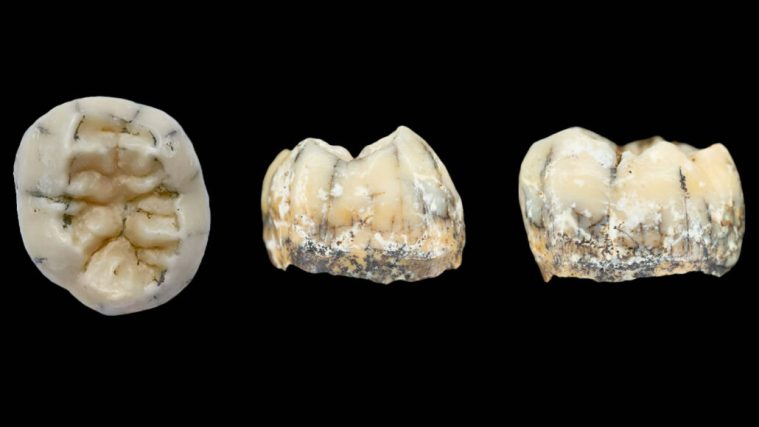
There have been suggestions that at least some of the ‘archaic’ human remains found widely and abundantly in China may have been Denisovans; although they might equally be of Homo erectus. But none of the Chinese fossils have been subjected to gene sequencing – those found in caves outside tropical and sub-tropical climates might retain DNA just as well as Neanderthal and even older remains in temperate Europe. Yet a partial lower jaw discovered in a cave on the Tibetan Plateau (at 35°N) did yield proteins that had close affinities to those recovered from Siberian Denisovans. Now similar analyses have been performed on an abnormally large molar found in a cave in Northern Laos, showing that it too is most likely to be from a young (as suggested by its being little worn), possibly female (it lacks male-specific peptides), Denisovan. The locality lies at about 20°N, far to the south of the other two Denisovan sites (Demeter, F. et al. A Middle Pleistocene Denisovan molar from the Annamite Chain of northern Laos. Nature Communications, v. 13, article 2557; DOI: 10.1038/s41467-022-29923-z). Sparse as the evidence is, Denisovans were able to tolerate climate differences across 30 degrees of latitude.
The Wikipedia entry for Denisovans is a mine of additional information. For instance, detailed analysis of the roughly 5% of their genome that indigenous people of New Guinea carry suggests that the two groups may have interbred there as late as 30 ka. Since Both New Guinea and Australia were until 8 thousand years ago part of the Sahul landmass when sea level was low during the last ice age, these inferences add tropical occupancy to the Denisovan range. Does this suggest that Papuans and indigenous Australians migrated with Denisovans, or had the latter crossed the sea from Timor earlier and independently, after moving from Asia by ‘hopping’ from island to island through eastern Indonesia? There is a possibility that Denisovans could even have survived in Sahul until as late as 14.5 ka. Even more odd, modern Icelandic people are unique among Europeans in having detectable traces of Denisovan DNA. However, rather than having been directly shared between Denisovans and ancestral Scandinavians – a possibility – it may have been carried by Neanderthal-Denisovan hybrids migrating westwards from Siberia with whom the Icelanders’ ancestors interbred. There are other interesting points in the Wikipedia entry. One is that the consistently lower Denisovan ancestry in living East Asians compared with people of Oceania, may indicate two separate waves of eastward migration by AMH. The latter may have arrived first, had greater contact with Denisovans and then moved on across seaways to remain isolated from the later migrants.
Finally, something that puzzles me as a non-geneticist. If both Denisovans and Neanderthals died out as genetically distinct groups tens of millennia ago how could the genetic traces of interbreeding with AMH have been retained at such high levels until the present; i.e. through thousands of generations? Each of us carries a 50% deal of genes from our parents. Then with each subsequent generation the proportion is diluted, so that we inherit 25% from grandparents, 12.5 % from great-grandparents and so on. Yet Papuans still have 5 to 6 percent of Denisovan DNA: much the same holds for Europeans’ Neanderthal heritage. Does such a high level of retention of this ancestry suggest that a large proportion of the earliest migrating AMH individuals stemmed from generation to generation interbreeding on a massive scale? Did the ‘newcomers’ and ‘locals’ band eventually together almost completely to merge genetically, or am I missing something … ? Probably