British government fracking fan fracked

In November 2019 the Conservative government of Boris Johnson declared a moratorium on development of shale gas by hydraulic fracturing (‘fracking’) in England. This followed determined public protests at a number of potential fracking sites, the most intransigent being residents of Lancashire’s Fylde peninsula. They had been repeatedly disturbed since mid 2017 by low-magnitude earthquakes following drilling and hydraulic-fluid injection tests by Cuadrilla Resources near Little Plumpton village. Their views were confirmed in a scientific study by the British Geological Survey for the Oil and Gas Authority that warned of the impossibility of predicting the magnitude of future earthquakes that future fracking might trigger. The shale-gas industry of North America, largely in areas of low population and simple geology, confirmed the substantial seismic hazard of this technology by regular occurrences of earthquakes up to destructive magnitudes greater than 5.0. The Little Plumpton site was abandoned and sealed in February 2022.

Cuadrilla’s exploratory fracking site near Little Plumpton in Fylde, Lancashire. (Credit: BBC)

On 22 September 2022 the moratorium was rescinded by Jacob Rees-Mogg, Secretary of State for Business, Energy and Industrial Strategy in the new government of Liz Truss, two weeks after his appointment. This was despite the 2019 Conservative manifesto pledging not to lift the moratorium unless fracking was scientifically proven to be safe. His decision involved suggesting that the seismicity threshold for pausing fracking operations be lifted from magnitude 0.5 to 2.5, which Rees-Mogg claimed without any scientific justification to be ‘a perfectly routine natural phenomenon’.  He further asserted that opposition to fracking was based around ‘hysteria’ and public ignorance of seismological science, and that some protestors had been funded by Vladimir Putin. In reality the Secretary of State’s decision was fuelled by the Russian Federation’s reducing gas supplies to Europe following its invasion of Ukraine, the soaring world price of natural gas and an attendant financial crisis. There was also a political need to be seen to be ‘doing something’, for which he has a meagre track record in the House of Commons. Rees Mogg claimed that lifting the moratorium would bolster British energy security. That view ignored the probable lead time of around 10 years before shale gas can become an established physical resource in England. Furthermore, an August 2018 assessment of the potential of UK shale-gas, by a team of geoscientists, including one from the British Geological Survey, suggested that shale-gas potential would amount to less than 10 years supply of UK needs: contrary to Rees-Mogg’s claim that England has ‘huge reserves of shale’. Indeed it does, but the vast bulk of these shales have no commercial gas potential.

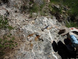
Ironically, the former founder of Cuadrilla Resources, exploration geologist Chris Cornelius, and its former public affairs director, Mark Linder, questioned the move to unleash fracking in England, despite supporting shale-gas operations where geologically and economically appropriate. Their view is largely based on Britain’s highly complex geology that poses major technical and economic challenges to hydraulic fracturing. Globally, fracking has mainly been in vast areas of simple, ‘layer-cake’ geology. A glance at large-scale geological maps of British areas claimed to host shale-gas reserves reveals the dominance of hundreds of faults, large and small, formed since the hydrocarbon-rich shales were laid down. Despite being ancient, such faults are capable of being reactivated, especially when lubricated by introduction of fluids. Exactly where they go beneath the surface is unpredictable on the scales needed for precision drilling.  Many of the problems encountered by Cuadrilla’s Fylde programme stemmed from such complexity. Over their 7 years of operation, hundreds of millions of pounds were expended without any commercial gas production. Each prospective site in Britain is similarly compartmentalised by faulting so that much the same problems would be encountered during attempts to develop them. By contrast the shales fracked profitably in the USA occur as horizontal sheets deep beneath entire states: entirely predictable for the drillers. In Britain, tens of thousands of wells would need to be drilled on a ‘compartment-by-compartment’ basis at a rate of hundreds each year to yield useful gas supplies. Fracking in England would therefore present unacceptable economic risks to potential investors. Cornelius and Linder have moved on to more achievable ventures in renewables such as geothermal heating in areas of simple British geology.

Jacob Rees-Mogg’s second-class degree in history from Oxford and his long connection with hedge-fund management seem not to be appropriate qualifications for making complex geoscientific decisions. Such a view is apparently held by several fellow Conservative MPs, one of whom suggested that Rees-Mogg should lead by example and make his North East Somerset constituency the ‘first to be fracked’, because it is underlain by potentially gas-yielding shales. The adjoining constituency, Wells, has several sites with shale-gas licences but none have been sought within North East Somerset. Interestingly, successive Conservative governments since 2015, mindful of a ‘not-in-my-backyard’ attitude in the party’s many rural constituencies, have placed a de-facto ban on development of onshore wind power.

Fracking in the UK; will it happen?

Whether or not one has read the Tractatus Logico-Philosophicus of Ludwig Wittgenstein, there can be little doubt that one of his most famous quotations can be applied to much of the furore over hydraulic fracturing (fracking) of hydrocarbon-rich shale in south-eastern Britain: ‘Whereof one cannot speak, one must remain silent’ (more pithily expressed by Mark Twain as ‘Better to remain silent and be thought a fool than to speak and remove all doubt’). A press release by the British Geological Survey  in late May 2014 caused egg to appear on the shirts of both erstwhile ‘frackmeister’ David Cameron (British Prime Minister) and anti-fracking protestors in Sussex. While there are oil shales beneath the Weald, these Jurassic rocks have never reached temperatures sufficient to generate any significant gas reserves (see: Upfront, New Scientist, 31 May 2014 issue, p. 6). Yet BGS estimate the oil shales to contain a total of 4.4 billion barrels of oil. That might sound a lot, but the experience of shale fracking companies in the US is that, at best, only about 5% can be recovered and, in cases that are geologically similar to the Weald, as little as 1% might be expected. Between 44 and 220 million barrels is between two and six months’ worth of British oil consumption; and that is only if the entire Wealden shales are fracked.

Areas where petroleum-rich shales occur at the surface in Britain. (credit: British Geological Survey)

Why would any commercial exploration company, such as Cuadrilla, go to the trouble of drilling wells, even of an ‘exploratory nature’, for such meager potential returns? Well, when there is sufficient hype, and the British Government has gushed in this context for a few years, bigger fish tend to bite and cash flows improve. For instance, Centrica the owner of British Gas forked out $160 million to Cuadrilla in June 2013 for a quarter share in the well-publicised licence area near Blackpool in Lancashire; the grub stake to allow Cuadrilla to continue exploration in exchange for 25% of any profit should commercial quantities of shale-gas be produced.

Sedimentary rock sequences further north in Britain whose geological evolution buried oil shales more deeply are potential gas producers through fracking; an example is the Carboniferous Bowland Shale beneath the Elswick gasfield in west Lancashire, targeted by Cuadrilla. Far greater potential may be present in a large tract of the Pennine hills and lowlands that flank them where the Bowland Shale occurs at depth.

Few people realize just how much detail is known about what lies beneath their homes apart from maps of surface geology. That is partly thanks to BGS being the world’s oldest geological survey (founded in 1835) and partly the sheer number of non-survey geologists who have prowled over Britain for 200 years or more and published their findings. Legally, any excavation, be it an underground mine, a borehole or even the footings for a building, must be reported to BGS along with whatever geological information came to light as a result. The sheer rarity of outcropping rock in Britain is obvious to everyone: a legacy of repeated glaciation that left a veneer of jumbled debris over much of the land below 500m that lies north of the northern outskirts of the London megalopolis. Only highland areas where glacial erosion shifted mullock to lower terrains have more than about 5% of the surface occupied by bare rock. Of all the data lodged with BGS by far the most important for rock type and structure at depth are surveys that used seismic waves generated by vibrating plates deployed on specialized trucks. These and the cables that connected hundreds of detectors were seen along major and minor roads in many parts of Britain during the 1980s during several rounds of licenced onshore exploration for conventional petroleum resources. That the strange vehicles carried signs saying Highway Maintenance lulled most people apart from professional geologists as regards their actual purpose. Over 75 thousand kilometers of seismic sections that penetrated thousands of metres into the Earth now reside in the UK Onshore Geophysical Library (an Interactive Map at UKOGL allows you to see details of these surveys, current areas licenced for exploration and the locations of various petroleum wells).

Seismic survey lines in northern England (green lines) from the interactive map at the UK Onshore Geophysical Library

Such is the detail of geological knowledge that estimates of any oil and gas, conventional or otherwise, residing beneath many areas of Britain are a lot more reliable than in other parts of the world which do not already have or once had a vibrant petroleum industry. So you can take it that when the BGS says there is such and such a potential for oil or gas beneath this or that stretch of rural Britain they are pretty close to the truth. Yet it is their raw estimates that are most often publicized; that is, the total possible volumes. Any caveats are often ignored in the publicity and hype that follows such an announcement. BGS recently announced that as much as 38 trillion cubic metres of gas may reside in British shales, much in the north of England. There followed a frenzy of optimism from Government sources that this 40 years’ worth of shale gas would remove at a stroke Britain’s exposure to the world market of natural gas, currently dominated by Russia, and herald a rosy economic future to follow the present austerity similar to the successes of shale-gas in North America. Equally, there has been fear of all kinds of catastrophe from fracking on our ‘tight little island’ especially amongst those lucky enough not to live in urban wastelands. What was ignored by both tendencies was reality. In the US, fracking experience shows that only 10% at most of the gas in a fractured shale can be got out; even the mighty Marcellus Shale of the NE US underlying an area as big as Britain can only supply 6 years of total US gas demand. Britain’s entire shale-gas endowment would serve only 4 years of British gas demand.

To tap just the gas in the upper part of the Bowland basin would require 33 thousand fracking wells in northern Britain. Between 1902 and 2013 only 19 onshore petroleum wells were drilled here in an average year. To make any significant contribution to British energy markets would require 100 per annum at a minimum. Yet, in the US, the flow rate from fracked wells drops to a mere zephyr within 3 years. Fracking on a large scale may well never happen in Britain, such are the largely unstated caveats. But the current hype is fruitful for speculation that it will, and that can make a lot of cash sucked in by the prospect – without any production whatsoever.

Enhanced by Zemanta

Review of fracking issues

The release and exploitation of natural gas from shales using the unconventional means of in situ hydraulic fracturing – ‘fracking’ – has had plenty of bad press, including some hammering in Earth Pages. Now, what seems to be a balanced academic review has appeared on-line in Science magazine (Vidic, R.D. et al. 2013. Impact of shale gas development on regional water quality. Science, v. 340, DOI: 10.1126/science.1235009). The review focuses on hazards to groundwater resources from a variety of environmental effects, primarily gas migration, contaminant transport through induced and natural fractures, wastewater discharge, and accidental spills.

English: Protests against shale gas drilling i...
Protests against shale gas drilling in Bulgaria (credit: Wikipedia)

Much attention has centred on faulty seals put in place to stop gas escaping from drill targets. Yet fewer than 3% of seals are said to have proved problematic, with some finger-pointing at natural gas leakage from the hydrocarbon-rich shales. After all, there are plenty of natural fractures and completely ‘tight’ stratigraphic sequences are rare. in fact toxic effects of natural gas leakage on surface vegetation have been widely used as exploration indicators for conventional petroleum. The review does point out that there are so few pre-drilling studies of natural leakage that this controversy – including widely publicised blazing household water supplies – can not yet be resolved. Obviously more independent monitoring of areas above prospective shales are essential; but who will fund them? The one well-documented before-and-after study, from 48 water wells in Pennsylvania, USA, showed no change, though it seems that monitoring after fracking was short-lived.

The chemically-charged water used to induce the hydrofracturing obviously leaves an unmistakable mark when leaks occur, and there have been cases of considerable environmental release. The fluids are indeed a wicked brew of acids, organic thickeners, biocides, alkalis and inorganic surfactants, to name but a few infredients. To some extent re-use of such fluids, which are costly, ought to mitigate risks. However, once a shale-gas field is fully developed, large volumes of the fracking fluids remain in the subsurface and may leak into shallow groundwater sources. But what pathways do these fluids follow when they are pumped into shales under very high pressure? The review warns of the lesson of toxic fluid leakage from underground coal mines.

The University of Pittsburgh team who compiled the review usefully outline why shale gas is both profitable and feasible. They deal with what methane does in an environmental chemistry sense. It isn’t a solvent, so carries no other materials such as toxic ions, but its interaction with bacteria creates reducing conditions. A now well-known hazard of subsurface reduction is dissolution of iron hydroxide, naturally an important component of many rocks, that can adsorb a great range of dangerous ions at potentially high concentrations, including those involving arsenic. Reductive dissolution lets such ions loose into natural waters, even at shallow depths. Yet methane is emitted by a host of sources other than hydrocarbon-rich shale: landfill; swamps; other bacterial action; conventional petroleum fields both active and abandoned; and even deep water boreholes themselves. A recent study of groundwater geochemistry in relation to fracking in Arkansas, USA (Warner, N.R. et al. 2013. Geochemical and isotopic variations in shallow groundwater in areas of the Fayetteville shale development, north-central Arkansas. Applied Geochemistry, v. 33, doi/10.1016/j.apgeochem.2013.04.013) does address changes in groundwater chemistry, but not for all the ions cited by the WHO as potential hazards.

Whereas the mechanisms involved in vertical and lateral migration of subsurface fluids are well understood there is little knowledge of natural structural features such as deep jointing, fractures and fault fragmentation that control actual migration from area to area. The use of natural seepage as an exploration guide was largely abandoned when many studies showing apparently high-priority targets proved to be far removed from the actual source of the moving fluids. The most easily investigated route for leakage is the actual ‘plumbing’ that fracking uses. This is held together by cement that high pressures can disrupt before it sets, resulting in leaks. A lot depends on ‘due diligence’ deployed by the contractors, whose regulation can leave a lot to be desired. Vidic and colleagues devote most space to the matter of wastewater and deep formation water, yet make little if any case for routine geochemical monitoring of domestic groundwater supplies in shale-gas fields. Much is directed at the industry itself rather than independent surveys.

Porphyry deposits and the fracking mechanism

brothers in arms
Porphyry sculpture of two of the four co-emperors of the late Roman Empire – the Tetrarchy (credit: mhobl via Flickr)

For about a century a style of mineral deposit that develops in and around shallow, silicic magma chambers has dominated world supplies of copper, molybdenum and, more rarely, tin. They are also enriched in other valuable elements, including gold and silver, which makes these deposits even more attractive to mine. Hosting them are fine-grained diorites and granodiorites that typically contain large crystals of quartz and feldspar set in the finer material. Technically such rocks are called porphyries; well not so technical because the name derives from many porphyries having a colour much valued by Egyptian and especially Roman  sculptors and architects – a reddish purple close to that on the hem of an nobleman’s toga. The dye comes from the ‘purple’ fish – the marine mollusc Murex brandaris – which the ancient Greeks referred to as porphura. In Rome, ‘The Purple’ were the nobs, and today they are the cardinals. The connection is coincidental, the best and most enduring rocks for sculpting and making pyramids are of this kind, but happen to be purple. Of course, there are igneous rocks with the eponymous texture but different colours, but stonemasons in the ancient world never bothered to give them a special name

The porphyritic texture signifies to virtually every geologist a magmatic history in which an igneous magma resided deep in the crust slowly crystallizing large mineral grains. Then, for one reason or another, it was blurted towards the surface. Porphyry copper and molybdenum deposits have a disturbingly phallic shape; a tall, rough cylinder capped by a bell-shaped zone of mineralisation. And they are pretty big, the largest at Bingham Canyon in Utah, USA once having been ~2.5 km tall and 0.5 km wide, with a 2 km, bell-shaped zone of mineralisation affecting the intrusion and its surrounding country rock.

Bingham Canyon Mine
The world’s largest open-pit mine in the porphyry copper deposit at Bingham Canyon Utah (credit: Wikipedia)

Porphyry ores are not much for the rock aficionado to shout about and they are characterized by very low grades of ore, the metal-sulfide ore minerals and any gold being barely visible. They are economic because there is a great deal of rock with copper and molybdenum contents often less than 0.5%, and economic gold values less than a part per million (0.03 troy oz t-1). The bulk and the diversity of metals make mining porphyry deposits profitable. The ore minerals occur in tiny cracks that pervade the deposits forming a ‘stockwork’. That is where this style of mineralisation has a link with fracking shales to release their gas content. Stockworks are produced by very high-pressure steam that explosively fractures every cubic metre of the orebody. Crystallisation of sulfides and barren minerals keeps the fractures open until the system runs out of steam and mineralising fluids. Modelling of the thermodynamics associated with porphyry intrusions now suggests that once pressure and temperature stabilise at the requisite levels the hydraulic fracturing becomes self-sustaining (Weis, P. et al. 2012. Porphyry-copper ore shells form at stable pressure-temperature fronts within dynamic fluid plumes. Science, v. 338, p. 1613-1616). The key is the ‘fracking’ and as ‘shells’ with the right conditions migrate through the upper part of the intrusive system groundwater is drawn in to the freshly permeable rock to dissolve, transport and, where chemical conditions permit, to precipitate metals in the cracks. The modelling suggests a fundamental process that extends from plutonic systems, through volcanic edifices, hydrothermal processes in shallower rocks and active geothermal systems that vent to the surface.

Stockwork in copper-molybdenum porphyry deposit in Mexico (credit: Sundance Minerals)

In many respects the universality of hydraulic fracturing associated with increased heat flow, which itself can affect the crust repeatedly, may be the key to the concept of ‘metallogenic provinces’. These are large areas in which economic mineralisation of many styles but with much the same ‘blend’ of metals seems to have formed again and again during crustal evolution. Such provinces emerged from exploration and mining to present explorationists with the old adage, ‘To find an elephant go to elephant country’. Now there may be a theoretical basis on which new discoveries may be made.

Britain to be comprehensively fracked?

Tower for drilling horizontally into the Marce...
Drill rig in Pennsylvania aimed at hydraulic fracturing of the hydrocarbon-rich Marcellus Shale of Devonian age. Image via Wikipedia

In ‘Fracking’ shale and US ‘peak gas’ (EPN of 1 July 2010) I drew attention to the relief being offered to dwindling US self-sufficiency in natural gas by new drilling and subsurface rock-fracturing technologies that opens access to extremely ‘tight’ carbonaceous shale and the gas it contains. The item also hinted at the down-side of shale-gas. The ‘fracking’ industry has grown at an alarming rate in the USA, now supplying more than 20% of US demand for gas. This side of the Atlantic the once vast reserves of North Sea gas fields are approaching exhaustion. This is at a time when commitments to reducing carbon emissions dramatically depend to a large extent on hydrocarbon gas supplanting coal to generate electricity, releasing much lower CO2  by burning hydrogen-rich gases such as methane (CH4) than by using coal that contains mainly carbon. Without alternative, indigenous supplies declining gas reserves in Western Europe also seem likely to enforce dependency on piped gas from Russia or shipment of liquefied petroleum gas from those major oil fields that produce it. The scene has been set in Europe in general and Britain in particular for a massive round of exploration aimed at alternative gas sources beneath dry land. Unlike the US and Canada, the British are not accustomed to on-shore drilling rigs, seismic exploration and production platforms, and nor are most Europeans. Least welcome are the potential environmental and social hazards that have been associated with the US fracking industry, which seem a greater threat in more densely populated Europe.

The offshore oil and gas of the North Sea fields formed by a process of slow geothermal heating of solid hydrocarbons or kerogen in source rocks at a variety of stratigraphic levels, escape into surrounding rocks of the gases and liquids produced by this maturation, and their eventual migration and accumulation in geological traps. By no means all products of maturation leave shale source rocks because of their very low permeability. That residue may be much more voluminous than petroleum liquids and gases in conventional reservoir rocks; hence the attraction of fracking carbonaceous shales. British on-shore geology is bulging with them, particularly Devonian and Carboniferous lacustrine mudstones, Carboniferous and Jurassic coals, and the marine black shales of the Jurassic (see http://www.bgs.ac.uk/research/energy/shaleGas.html and https://www.og.decc.gov.uk/upstream/licensing/shalegas.pdf), to the extent that areas of potential fracking cover around a third of England, Wales and southern Scotland.

News is breaking of a major shale-gas discovery beneath Blackpool, the seaside resort ‘noted for fresh air and fun, where Mr and Mrs Ramsbottom went with Young Albert their son…’ (Albert poked a stick at Wallace the lion and was eaten), said by energy firm Cuadrilla to have gas reserves of 5.7 trillion m3. The announcement followed 6 months of exploratory drilling, and drew attention to the burgeoning interest by entrepreneurs in the upcoming 14th Onshore Licensing Round for petroleum exploration in Britain. It isn’t just from major petroleum companies, but in some cases even what amount to family businesses finding sufficient venture capital to spud wells; similar in many respects to the US fracking boom that began a mere 10 years ago.