Was Venus once habitable?

The surface of Venus from the USSR Venera 14 lander

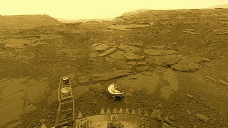
It is often said that Earth has a twin: Venus, the second planet from the Sun. That isn’t true, despite the fact that both have similar size and density. Venus, in fact, is even more inhospitable that either Mars or the Moon, having surface temperatures (~465°C) that are high enough to melt lead or, more graphically, those in a pizza oven. The only vehicles successfully to have landed on Venus (the Russian Venera series) survived for a mere 2 hours, but some did did send back data and images. That near incandescence is masked by the Venusian atmosphere that comprises 96.5% carbon dioxide, 3.5% nitrogen and 0.05 % sulfur dioxide, with mere traces of other gases including extremely low amounts of water vapour (0.002%) and virtually no oxygen. The dense atmosphere imposes a pressure at Venus’s surface tht is 92 times that on Earth: so dense that CO2 and N2 are, strictly speaking, not gases but supercritical fluids at the surface. At present Venus is definitely inimical to any known type of life. It is the victim of an extreme, runaway greenhouse effect.

As it stands, Venus’s geology is also very different from that of the Earth. Because its upper atmosphere contains clouds of highly reflective sulfuric acid aerosols only radar is capable of penetrating to the surface and returning to have been monitored by a couple of orbital vehicles: Magellan (NASA 1990 to 1994) and Venus Express (European Space Agency 2006 to 2014). The latter also carried means of mapping Venus’s surface gravitational field. The radar imagery shows that 80% of the Venusian surface comprises somewhat wrinkled plains that suggests a purely volcanic origin. Indeed more that 85,000 volcanoes have been mapped, 167 of which are over 100 km across. Much of the surface appears to have been broken into polygonal blocks or ‘campuses’ (campus is Latin for field) that give the impression of ‘crazy paving’. A peculiar kind of local-scale tectonics has operated there, but nothing like the plate tectonics on Earth in either shape or scale.

Polygonal blocks or ‘campuses’ on the lowland surface of Venus. Note the zones of ridges that roughly parallel ‘campus’ margins. Credit: Paul K. Byrne, North Carolina State University and Sean C. Solomon, Lamont-Doherty Earth Observatory

Many of the rocky bodies of the solar system are pocked by impact craters – the Earth has few, simply because erosion and sedimentary burial on the continents, and subduction of ocean floors have removed them from view. The Venusian surface has so few that it can, in its entirety, be surmised to have formed by magmatic ‘repaving’ since about 500 Ma ago at least. Earlier geological process can only be guessed at, or modelled in some way. A recent paper postulates that ‘there are several lines of evidence that suggest that Venus once did have a mobile lithosphere perhaps not dissimilar to Earth …’ (Weller, M.B. & Kiefer, W.S. 2025. The punctuated evolution of the Venusian atmosphere from a transition in mantle convective style and volcanic outgassing. Science Advances, v. 11, article eadn986; DOI: 10.1126/sciadv.adn986). One large, but subtle feature may have formed by convergence similar to that of collision tectonics. There are also gravitational features that hint at active subduction at depth, although the surface no longer shows connected features such as trenches and island arcs. Local extension has been inferred from other data.

Weller and Kiefer suspect that Venus in the past may have shifted between a form of mobile plate tectonics and stagnant ‘lid’ tectonics, the vast volcanic plains having formed by processes akin to flood volcanism on a planetary scale. Venus’s similar density to that of Earth suggests that it is made of similar rocky material surrounding a metallic core. However, that planet has a far weaker magnetic field suggesting that the core is unable to convect and behave like a dynamo to generate a magnetic field. That may explain why the atmosphere of Venus is almost completely dry. With no magnetic field to deflect it the solar wind of charged particles directly impacts the upper atmosphere, in contrast to the Earth where only a very small proportion descends at the poles. Together with the action of UV solar radiation that splits water vapour into its constituent hydrogen and oxygen ions, the solar wind adds energy to them so that they escape to space. This atmospheric ‘erosion’ has steadily stripped the atmosphere of Venus – and thus its solid surface – of all but a minute trace of water, leaving behind higher mass molecules, particularly carbon dioxide, emitted by its volcanism. Of course, this process has vastly amplified the greenhouse effect that makes Venus so hot. Early on the planet may have had oceans and even primitive life, which on Earth extract CO2 by precipitating carbonates and by photosynthesis, respectively. But they no longer exist.

The high surface temperature on Venus has made its internal geothermal gradient very different from Earth’s; i.e. increasing from 465°C with depth, instead of from about 15°C on Earth. As a result, everywhere beneath the surface of Venus its mantle has been more able to melt and generate magma. Earlier in its history it may have behaved more like Earth, but eventually flipped to continual magmatic ‘repaving’. To investigate how this evolution may have occurred Weller and Kiefer created 3-D spherical models of geological activity, beginning with Earth-like tectonics – a reasonable starting point because of the probable Earth-like geochemistry of Venus. My simplified impression of what they found is that the periodic blurting of magma well-known from Earth history to have created flood-basalt events without disturbing plate tectonics proceeded on Venus with progressively greater violence. Such events here emitted massive amounts of CO2 into the atmosphere over short (~1 Ma) time scales and resulted in climate change, but Earth’s surface processes have always returned to ‘normal’. Flood-basalt episodes here have had a rough periodicity of around 35 Ma. Weller and Kiefer’s modelling seems to suggest that such events on Venus may have been larger. Repetition of such events, which emitted CO­2 that surface processes could not erase before the next event, would progressively ramp up surface temperatures and the geothermal gradient.  Eventually climatic heating would drive water from the surface into the atmosphere, to be lost forever through interaction with the solar wind. Without rainfall made acid by dissolved CO2, rock weathering that tempers the greenhouse effect on Earth would cease on Venus. The increased geothermal gradient would change any earlier rigid, Earth-like lithosphere to more ductile material, thereby shutting down the formation of plates, the essence of tectonics on Earth. It may have been something along those lines that made Venus inimical to life, and some may fear that anthropogenic global warming here might similarly doom the Earth to become an incandescent and sterile crucible orbiting the Sun. But as Mark Twain observed in 1897 after reading The New York Herald’s account that he was ill and possibly dying in London, ‘The report of my death was an exaggeration’. It would suit my narrative better had he said ‘… was premature’!

The Earth has a very large Moon because of a stupendous collision with a Mars-sized planet shortly after it accreted. That fundamentally reset Earth’s bulk geochemistry: a sort of Year Zero event. It endowed both bodies with magma oceans from which several tectonic scenarios developed on Earth from Eon to Eon. There is no evidence that Venus had such a catastrophic beginning. By at least 3.7 billion years ago Earth had a strong magnetic field. Protected by that thereafter from the solar wind, it has never lost its huge endowment of water; solid, liquid or gaseous. It seems that it did go through a stagnant lid style of tectonics early on, that transitioned to plate tectonics around the end of the Hadean Eon (~4.0 Ga), with a few hiccups during the Archaean Eon. And it did develop life as an integral part of the rock cycle. Venus, fascinating as it is, shows no sign of either, and that’s hardly surprising. Those factors and its being much closer to the Sun may have condemned it from the outset.

A fully revised edition of Steve Drury’s book Stepping Stones: The Making of Our Home World can now be downloaded as a free eBook

Global natural hydrogen resources: a CO2 free future??

The idea of a ‘Hydrogen Economy’ has been around for at least six decades, its main attraction being that when hydrogen is burned it combines with oxygen to form H2O. It might seem to be the ultimate ‘green’ energy source, but it is currently being touted by governments and petroleum companies in what is widely regarded as ‘green washing’. The technology favoured by that axis uses steam reforming of the methane that dominates natural petroleum gas, through the reaction:

CH4 + H2O  → CO + 3H2

It’s actually not much different from producing coke gas from coal, which began in the 19th century and is now largely abadoned. Because carbon monoxide (CO) reacts with atmospheric oxygen to form CO2 this process is by no means ‘green’ and is properly referred to as ‘grey’ hydrogen. Only if the CO is stored permanently underground could steam reforming not add to greenhouse warming. That puts the approach in the same category as ‘carbon capture and storage’, with all the possible difficulties inherent in that technology, which has yet to be demonstrated on a large scale. Such hydrogen is classified as a ‘blue’. Colour coding hydrogen is described nicely by the British National Grid. They give another six varieties. Green and yellow hydrogen are produced by electrolysing water using wind or solar power respectively. The pink variety uses nuclear power in the same fashion. Black or brown hydrogen is that produced by coking coal or stewing-up brown coal (lignite) which amazingly are contemplated in Australia and Germany. There is even a turquoise variety can be produced if methane is somehow turned into hydrogen and solid carbon using renewables. There is another category (white) which is hydrogen produced by a variety of natural, geochemical processes.

Distribution of ophiolites around the Eastern Mediterranean and Black Seas. Many orogenic belts are endowed to a similar extent. (Credit: Gültekin Topuz, Istanbul Technical University)

Earth-logs discussed white hydrogen in March 2023 when news emerged of gas that was 98% hydrogen leaking from a water borehole in Mali. The local people harnessed this surprising resource to generate electricity for their village. It also emerges in springs from ultramafic rocks, having formed through weathering of the mineral olivine:

3Fe2SiO4 + 2H2O → 2 Fe3O4 + 3SiO­2 +3H2

Much the same reaction occurs beneath the ocean floor where hydrothermal fluids alter basalts and in geothermal springs that emerge from onshore basalt lavas. Such ‘white’ hydrogen emissions are widespread. So an unknown, but possibly huge amount of hydrogen is leaking into the atmosphere continuously. Because of its tiny nucleus – just a single proton – atmospheric hydrogen quickly escapes to outer space: what a waste! Equally as interesting is that inducing the breakdown of ultramafic rock to yield hydrogen, by pumping water and carbon dioxide into them, may also be a means of leak-free carbon sequestration. This produces the complex mineral serpentine and magnesium carbonate. The reaction gives off heat and so is self sustaining until pumping is stopped.

It has been estimated that by 2050 the annual global demand for hydrogen will reach 530 million t.  Just how big is the potential resource to meet such a demand? Natural weathering and hydrothermal processes have always functioned. Some of the hydrogen produced by them may have built-up in reservoirs like the one in Mali, some is escaping. Neither the magnitude of annual natural generation of hydrogen nor the amount trapped in porous sedimentary rocks are known in any detail. A recent survey of how much may be trapped gives a range from 103 to 1010 million metric tons (Ellis, G.S. & Gelman, S.E. 2024. Model predictions of global geologic hydrogen resources. Science Advances, v. 10, article eado0955; DOI: 10.1126/sciadv.ado0955), most probably 5.6 trillion t. If only a tenth of that is recoverable, replacing fossil-fuel energy with that from white hydrogen to achieve net-zero CO2 emissions would be sustainable for about 400 years. That magnitude of trapped hydrogen reserves well exceeds all proven reserves of natural gas.

This estimate assumes using only hydrogen that has been naturally produced and stored beneath the Earth’s surface. Basalts and ultramafic rocks exposed at the land surface as ophiolites – ancient oceanic crust thrust onto continental crust – are abundant on every continent. Inducing hydrogen-producing chemical reactions in them by pumping water and CO2 into them is little different from the technology being used in fracking. This potential resource is effectively limitless. Combined with renewable energy technology, a hydrogen economy has no conceivable need for fossil fuels, except as organic-chemistry feedstock. Such a scenario for stabilising climate is almost certainly feasible. It could use the capital, technology and skills currently deployed by the petroleum industry that is currently driving society and the Earth in the opposite direction. It is capable of drilling 10 km below the continental surface or the ocean floor, and even into the Earth’s mantle that is made of . . . ultramafic rock.

Best wishes for the festive season to all Earth-logs followers and visitors

A major breakthrough in carbon capture and storage?

Carbon capture and storage is in the news most weeks and is increasingly on the agenda for some governments. But plans to implement the CCS approach to reducing and stopping global warming increasingly draws scorn from scientists and environmental campaigners. There is a simple reason for their suspicion. State engagement, in the UK and other rich countries, involves major petroleum companies that developed the oil and gas fields responsible for unsustainably massive injection of CO2 into the atmosphere. Because they have ‘trousered’ stupendous profits they are a tempting source for the financial costs of pumping CO2 into porous sedimentary rocks that once contained hydrocarbon reserves. Not only that, they have conducted such sequestration over decades to drive out whatever petroleum fluids remaining in previously tapped sedimentary strata. For that second reason, many oil companies are eager and willing to comply with governmental plans, thereby seeming to be environmentally ‘friendly’. It also tallies with their ambitions to continue making profits from fossil-fuel extraction. But isn’t that simply a means of replacing the sequestered greenhouse gas with more of it generated by burning the recovered oil and natural gas; i.e. ‘kicking the can down the road’? Being a gas – technically a ‘free phase’ – buried CO2 also risks leaking back to the atmosphere through fractures in the reservoir rock. Indeed, some potential sites for its sequestration have been deliberately made more gas-permeable by ‘fracking’ as a means of increasing the yield of petroleum-rich rock. Finally, a litre of injected gas can drive out pretty much the same volume of oil. So this approach to CCS may yield a greater potential for greenhouse warming than would the sequestered carbon dioxide itself.

Image of calcite (white) and chlorite (cyan) formed in porous basalt due to CO2-charged water-rock interaction at the CarbFix site in Iceland. (Credit: Sandra Ósk Snæbjörnsdóttir)

Another, less widely publicised approach is to geochemically bind CO2 into solid carbonates, such as calcite (CaCO­3), dolomite (CaMgCO3), or magnesite (MgCO3). Once formed such crystalline solids are unlikely to break down to their component parts at the surface, under water or buried. One way of doing this is by the chemical weathering of rocks that contain calcium- and magnesium-rich minerals, such as feldspar (CaAl2Si2O8), olivine ([Fe,Mg]2SiO4) and pyroxene ([Fe,Mg]CaSi2O6) . Mafic and ultramafic rocks, such as basalt and peridotite are commonly composed of such minerals. One approach involves pumping the gas into a Icelandic borehole that passes through basalt and letting natural reactions do the trick. They give off heat and proceed quickly, very like those involved in the setting of concrete. In two experimental field trials 95% of injected CO2 was absorbed within 18 months. Believe it or not, ants can do the trick with crushed basalt and so too can plant roots. There have been recent experiments aimed at finding accelerants for such subsurface weathering (Wang, J. et al. 2024. CO2 capture, geological storage, and mineralization using biobased biodegradable chelating agents and seawater. Science Advances, v. 10, article eadq0515; DOI: 10.1126/sciadv.adq0515). In some respects the approach is akin to fracking. The aim is to connect isolated natural pores to allow fluids to permeate rock more easily, and to release metal ions to combine with injected CO2.

Chelating agents are biomolecules that are able to dissolve metal ions; some are used to remove toxic metals, such as lead, mercury and cadmium, from the bodies of people suffering from their effects. Naturally occurring ones extract metal ions from minerals and rocks and are agents of chemical weathering; probably used by the aforesaid ants and root systems. Wang and colleagues, based at Tohoku University in Japan, chose a chelating agent GLDA (tetrasodium glutamate diacetate –  C9H9NNa4O8) derived from plants, which is non-toxic, cheap and biodegradable. They injected CO2 and seawater containing dissolved GDLA into basaltic rock samples. The GDLA increases the rock’s porosity and permeability by breaking down its minerals so that Ca and Mg ions entered solution and were thereby able to combine with the gas to form carbonate minerals. Within five days porosity was increased by 16% and the rocks permeability increased by 26 times. Using electron microscopy the authors were able to show fine particles of carbonate growing in the connected pores. In fact these carbonate aggregates become coated with silica released by the induced mineral-weathering reactions. Calculations based on the previously mentioned field experiment in Iceland suggest that up to 20 billion tonnes of CO2 could be stored in 1.3 km3 of basalt treated in this way: about 1/25000 of the active rift system in Iceland (3.3 x 10⁴ km2 covered by 1 km of basalt lava). In 2023 fossil fuel use emitted an estimated 36.6 bllion tons of CO2 into the atmosphere.

So, why do such means of efficiently reducing the greenhouse effect not receive wide publicity by governments or the Intergovernmental Panel on Climate Change? Answers on a yellow PostIt™ please . . .

A new explanation for the Neoproterozoic Snowball Earth episodes

The Cryogenian Period that lasted from 860 to 635 million years ago is aptly named, for it encompassed two maybe three episodes of glaciation. Each left a mark on every modern continent and extended from the poles to the Equator. In some way, this series of long, frigid catastrophes seems to have been instrumental in a decisive change in Earth’s biology that emerged as fossils during the following Ediacaran Period (635 to 541 Ma). That saw the sudden appearance of multicelled organisms whose macrofossil remains – enigmatic bag-like, quilted and ribbed animals – are found in sedimentary rocks in Australia, eastern Canada and NW Europe. Their type locality is in the Ediacara Hills of South Australia, and there can be little doubt that they were the ultimate ancestors of all succeeding animal phyla. Indeed one of them Helminthoidichnites, a stubby worm-like animal, is a candidate for the first bilaterian animal and thus our own ultimate ancestor. Using the index for Palaeobiology or the Search Earth-logs pane you can discover more about them in 12 posts from 2006 to 2023. The issue here concerns the question: Why did Snowball Earth conditions develop? Again, refresh your knowledge of them, if you wish, using the index for Palaeoclimatology or Search Earth-logs. From 2000 onwards you will find 18 posts: the most for any specific topic covered by Earth-logs. The most recent are Kicking-off planetary Snowball conditions (August 2020) and Signs of Milankovich Effect during Snowball Earth episodes (July 2021): see also: Chapter 17 in Stepping Stones.

One reason why Snowball Earths are so enigmatic is that CO2 concentrations in the Neoproterozoic atmospheric were far higher than they are at present. In fact since the Hadean Earth has largely been prevented from being perpetually frozen over by a powerful atmospheric greenhouse effect. Four Ga ago solar heating was about 70 % less intense than today, because of the ‘Faint Young Sun’ paradox. There was a long episode of glaciation (from 2.5 to 2.2 Ga) at the start of the Palaeoproterozoic Era during which the Great Oxygenation Event (GOE) occurred once photosynthesis by oxygenic bacteria became far more common than those that produced methane. This resulted in wholesale oxidation to carbon dioxide of atmospheric methane whose loss drove down the early greenhouse effect – perhaps a narrow escape from the fate of Venus. There followed the ‘boring billion years’ of the Mesoproterozoic during which tectonic processes seem to have been less active. in that geologically tedious episode important proxies (carbon and sulfur isotopes) that relate to the surface part of the Earth System ‘flat-lined’.  The plethora of research centred on the Cryogenian glacial events seems to have stemmed from the by-then greater complexity of the Precambrian Earth System.

Since the GOE the main drivers of Earth’s climate have been the emission of CO2 and SO2 by volcanism, the sedimentary burial of carbonates and organic carbon in the deep oceans, and weathering. Volcanism in the context of climate is a two-edged sword: CO2 emission results in greenhouse warming, and SO2 that enters the stratosphere helps reflect solar radiation away leading to cooling. Silicate minerals in rocks are attacked by hydrogen ions (H+) produced by the solution of CO2 in rain water to form a weak acid (H2CO3: carbonic acid). A very simple example of such chemical weathering is the breakdown of calcium silicate:

CaSiO3  +  2CO2  + 3H2O  =  Ca2+  +  2HCO3  +  H4SiO4  

The reaction results in calcium and bicarbonate ions being dissolved in water, eventually to enter the oceans where they are recombined in the shells of planktonic organisms as calcium carbonate. On death, their shells sink and end up in ocean-floor sediments along with unoxidised organic carbon compounds. The net result of this part of the carbon cycle is reduction in atmospheric CO2 and a decreased greenhouse effect: increased silicate weathering cools down the climate. Overall, internal processes – particularly volcanism – and surface processes – weathering and carbonate burial – interact. During the ‘boring billion’ they seem to have been in balance. The two processes lie at the core of attempts to model global climate behaviour in the past, along with what is known about developments in plate tectonics – continental break-up, seafloor spreading and orogenies – and large igneous events resulting from mantle plumes. A group of geoscientists from the Universities of Sydney and Adelaide, Australia have evaluated the tectonic factors that may have contributed to the first and longest Snowball Earth of the Neoproterozoic: the Sturtian glaciation (717 to 661 Ma) (Dutkiewicz, A. et al. 2024. Duration of Sturtian “Snowball Earth” glaciation linked to exceptionally low mid-ocean ridge outgassing. Geology, v. 52, online early publication; DOI: 10.1130/G51669.1).

Palaeogeographic reconstructions (Robinson projection) during the early part of the Sturtian global glaciation: LEFT based on geological data from Neoproterozoic terrains on modern continents; RIGHT based on palaeomagnetic pole positions from those terrains. Acronyms refer to each terrains, e.g. Am is Amazonia, WAC is the West African Craton. Orange lines are ocean ridges, those with teeth are subduction zone. (Credit: Dutkiewicz et al., parts of Fig. 1)

Shortly before the Sturtian began there was a major flood volcanism event, forming the Franklin large igneous province, remains of which are in Arctic Canada. The Franklin LIP is a subject of interest for triggering the Sturtian, by way of a ‘volcanic winter’ effect from SO2 emissions or as a sink for CO through its weathering. But both can be ruled out as no subsequent LIP is associated with global cooling and the later, equally intense Marinoan global glaciation (655 to 632 Ma) was bereft of a preceding LIP. Moreover, a world of growing frigidity probably could not sustain the degree of chemical weathering to launch a massive depletion in atmospheric CO2. In search of an alternative, Adriana Dutkiewicz and colleagues turned to the plate movements of the early Neoproterozoic. Since 2020 there have been two notable developments in modelling global tectonics of that time, which was dominated by the evolution of the Rodinia supercontinent. One is based largely on geological data from the surviving remnants of Rodinia (download animation), the other uses palaeomagnetic pole positions to fix their relative positions: the results are very different (download animation).

Variations in ocean ridge lengths, spreading rates and oceanic crust production during the Neoproterozoic estimated from the geological (orange) and palaeomagnetic (blue) models. Credit: Dutkiewicz et al., parts of Fig. 2)

The geology-based model has Rodinia beginning to break up around 800 Ma ago with a lengthening of global constructive plate margins during disassembly. The resulting continental drift involved an increase in the rate of oceanic crust formation from 3.5 to 5.0 km2 yr-1. Around 760 Ma new crust production more than halved and continued at a much slowed rate throughout the Cryogenian and the early part of the Ediacaran Period.  The palaeomagnetic model delays breakup of the Rodinia supercontinent until 750 Ma, and instead of the rate of crust production declining through the Cryogenian it more than doubles and remains higher than in the geological model until the late Ediacaran. The production of new oceanic crust is likely to govern the rate at which CO2 is out-gassed from the mantle to the atmosphere. The geology-based model suggests that from 750 to 580 Ma annual CO2 additions could have been significantly below what occurred during the Pleistocene ice ages since 2.5 Ma ago. Taking into account the lower solar heat emission, such a drop is a plausible explanation for the recurrent Snowball Earths of the Neoproterozoic. On the other hand, the model based on palaeomagnetic data suggests significant warming during the Cryogenian contrary to a mass of geological evidence for the opposite.

A prolonged decrease in tectonic activity thus seems to be a plausible trigger for global glaciation. Moreover, reconstruction of Precambrian global tectonics using available palaeomagnetic data seems to be flawed, perhaps fatally. One may ask, given the trends in tectonic data: How did the Earth repeatedly emerge from Snowball episodes? The authors suggest that the slowing or shut-down of silicate weathering during glaciations allowed atmospheric CO2 to gradually build up as a result of on-land volcanism associated with subduction zones that are a quintessential part of any tectonic scenario.

This kind of explanation for recovery of a planet and its biosphere locked in glaciation is in fact not new. From the outset of the Snowball Earth hypothesis much the same escape mechanisms were speculated and endlessly discussed. Adriana Dutkiewicz and colleagues have fleshed out such ideas quite nicely, stressing a central role for tectonics. But the glaring disparities between the two models show that geoscientists remain ‘not quite there’. For one thing, carbon isotope data from the Cryogenian and Ediacaran Periods went haywire: living processes almost certainly played a major role in the Neoproterozoic climatic dialectic.

The dilemma of Rwanda’s Lake Kivu

In 1986 the small, roughly circular Lake Nyos in the Cameroon highlands silently released a massive cloud of carbon dioxide. Being a dense gas it hugged the ground and flowed down valleys for up to 25 km. 1700 local people perished by suffocation, together with their livestock (See Geohazards 2000). Having a recent volcanic origin, the lake is fed by springs in its bed that contain dissolved CO2 emitted from the residual magma chamber below. At 200 m deep the bottom water is sufficiently pressurised to retain the dissolved gas so that signs of the potential hazard remain hidden until such a limnic eruption occurs. Far larger, with a surface area of 2700 km2, Lake Kivu bordered by Rwanda and The Democratic Republic of Congo, is even deeper (up to 470 m). It too lies within a volcanically active zone, in this case the western arm of the East African Rift System. Being one of the most nutrient-rich bodies of fresh water on Earth, its biological productivity is extremely high, so as well as bottom water enriched in dissolved CO2 – a staggering 256 km3 – methane (CH4) is also present in very large amounts (~65 km3). This comes partly from anaerobic decay of dead organisms and from microbial reduction of the magmatic CO2 passing through its bottom sediments. Sulfate-reducing bacteria also generate toxic hydrogen sulfide (H2S) in the anoxic bottom waters – Lake Nyos contains less dissolved salts and did not emit H2S.

So Kivu presents a far greater hazard than the volcanic lakes of Cameroon and an emission of a dense gas mixture might fill the rift valley in the area to a depth of about a hundred metres. Being highly fertile the valley around the lake has a high population (2 to 3 million), so the death toll from a limnic eruption could be huge. A further hazard stems from tsunamis generated by such gas bursts. Once bubbles form at depth the bulk density of water drops, so large masses of water surge to the surface rather than the gas itself; a phenomenon known to happen in the periodic eruptions of Lake Nyos. What might trigger such an event in Lake Kivu? The East African Rift System is seismically active, but recent earthquakes did not result in limnic eruptions. Subaqueous volcanic eruption is the most likely to set one off. A surface lava flow from the nearby Mount Nyiragongo entered the lake at the town of Goma in 2002 but, fortunately, did not reach the threatening deeper part of Kivu. Sediment samples from the lake reveal periodic transport of land vegetation to its deeper parts, roughly every thousand years. The sediments with plant fossils also contain abundant remains of aquatic animals, suggesting both tsunamis accompanied by toxic emissions.

KIVUWATT’s methane extraction rig on Lake Kivu. (Credit: Contour Global)

Mitigating the hazard of limnic eruptions at Lake Nyos was made possible in 2002 by linking its bottom waters to the surface by plastic piping. After initial pumping, the release of bubbles at shallower depths and the resulting fall in bulk water density set off something akin to a large soda siphon, slowly relieving the deeper layers of their load of dissolved CO2. This resulted in 50 m high fountains of what was effectively soda ‘pop’. In 2009 this was repeated on a far larger scale on Lake Kivu, the operation being paid for by separation and sale of methane. Yet even this attempt at mitigation has its risks: first of destabilising what may be a fragile equilibrium to trigger a limnic eruption; second by lifting nutrient-rich bottom water that would encourage algal blooms at the lake surface and potential deoxygenation. The current issue of the Journal of African Earth Sciences includes a detailed review of the issues surrounding such dual-purpose hazard mitigation (Hirslund, F. & Morkel, P. 2020. Managing the dangers in Lake Kivu – How and why. Journal of African Earth Sciences, v. 161, Article 103672; DOI: 10.1016/j.jafrearsci.2019.103672). By 2015 the Rwandan KivuWatt Methane Project had a capacity for 25 MW of electrical power generation.

Running at full capacity, degassing the depths of Lake Kivu would provide the economic benefit of low-cost electricity for Rwanda and the DRC, at a maximum generating capacity of 300 mW using the most efficient power plant, as well as removing the risk of a catastrophic gas release. Yet the release of CO2 from the lake and from methane burning would increase atmospheric greenhouse warming significantly, albeit less than if the methane was simply released, for CH4 has 25 times the potential for trapping outgoing heat. Hence the dilemma. Either way, there remains the risk of turning Kivu’s surface water into an anoxic algal ‘broth’ with devastating effects on its fishery potential. Burial of the dead phytoplankton, however, might generate more methane by bacterial decay; a possible source of renewable biofuel that ‘recycles’ the atmospheric CO2 consumed by algal photosynthesis. The geohazards, according to Hirslund and Morkel, are really the ultimate driver for development of Lake Kivu’s fossil fuel potential, now that they are better understood as a real and present danger to millions of people. The authors calculate that a catastrophic gas release may be on the cards in the late 21st century. Yet there are other resource issues bound up with the health of the lake’s surface waters. Preserving the layered structure of the lake water to some extent is also important. Until the rates of natural infiltration of volcanic CO2 and biogenic production of methane are known, a minimum rate of gas extraction to make the lake safe is impossible to calculate. Perhaps matching those rates with gas removal should govern future operation. The total methane content of Lake Kivu is just 1.5 times the annual production from the UK sector of the North Sea. It is sufficient for power generation at 300 MW, at most, for 50 years, which would roughly double Rwanda’s current installed generation capacity – mainly from hydropower. Although Kivu is shared equally between Rwanda and the DRC even half of the short term power potential would be a significant benefit to Rwanda’s ~11 million people, though considerably less to the ~81 million living in the DRC; if access was equitable.