Chaos and the Palaeocene-Eocene thermal maximum

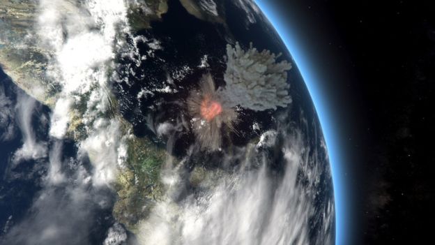
The transition from the Palaeocene to Eocene Epochs (56 Ma) was marked by an abrupt increase in global mean temperature of about 5 to 8°C within about 10 to 20 thousand years. That is comparable to a rate of warming similar to that currently induced by human activities. The evidence comes from the oxygen isotopes and magnesium/calcium ratios in the tests of both surface- and bottom dwelling foraminifera. The event is matched by a similarly profound excursion in the δ13C of carbon-rich strata of that age, whose extreme negative value marks the release of a huge mass of previously buried organic carbon to the atmosphere. The Epoch-boundary coincides with the beginning of rapid diversification among mammals and plants that had survived the end-Cretaceous mass extinction some 10 Ma beforehand. The most likely cause was the release of methane, a more potent greenhouse gas than CO2, from gas hydrate buried just beneath the surface of sea-floor sediments on continental shelves. An estimated mass of 1.5 trillion tonnes of released methane has been suggested. Methane rapidly oxidizes to CO2 in the atmosphere, which dissolves to make rainwater slightly acid so that the oceans also become more acid; a likely cause for the mass extinction of foraminifera species at the boundary.

Since the discovery of the Palaeocene-Eocene Thermal Maximum (PETM) in the late-1990s a range of possible causes have been suggested. Releasing methane suddenly from sea-floor gas hydrates needs some kind of trigger, such as a steady increase in the temperature of ocean-bottom water to above the critical level for gas-hydrate stability. The late-Palaeocene witnessed slow global warming by between 3 to 5°C over 4 to 5 Ma. There are several hypotheses for this precursor warming, such as a direct CO2 release from the mantle by volcanic activity for which there are several candidates in the geological record of the Palaeocene. Such surface warming would have had to be transferred to the sea floor on continental shelves to destabilise gas hydrates, which implicates a change in oceanic current patterns. An extraterrestrial cause has also been considered (see Impact linked to the Palaeocene-Eocene boundary event, Earth-logs October 2016). Sediment cores from the North Atlantic off the eastern seaboard of the US have revealed impact debris including glass spherules and shocked mineral grains at the same level as the PETM, together with iridium in terrestrial sediments onshore of the same age: there are no such global signatures). But apart from two small craters in Texas and Jordan (12 and 5 km across, respectively) of roughly the same age, no impact event of the necessary magnitude for truly global influence is known. However, there may have been an altogether different triggering mechanism.

Since the confirmation of the Milanković-Croll hypothesis to explain the cyclical shifts in climate during the Pleistocene Epoch in terms of changes in Earth’s orbital characteristics induced by varying gravitational forces in the solar system, the findings have been used as an alternative means of dating other stratigraphic events that show cyclicity. In essence, the varying forces at work are inherently chaotic in a formally mathematical sense. Although Milanković cycles sometimes pop-up when ancient, repetitive stratigraphic sequences are analysed, consistently using the method as a tool to calibrate the geological record to an astronomical timescale breaks down for sediments older than about 50 Ma. Calculations disagree markedly beyond that time. Richard Zeebe and Lucas Lourens of the Universities of Hawaii and Utrecht tried an opposite approach, using the known geological records from deep-sea cores to calibrate the astronomical predictions and, in turn, used the solution to take the astronomical time scale further back than 50 Ma (Zeebe, R.E. & Lourens, L.J. 2019. Solar System chaos and the Paleocene–Eocene boundary age constrained by geology and astronomy. Science, v. 365, p. 926-929; DOI: 10.1126/science.aax0612). They reached back about 8 Ma, so putting the PETM in focus. As well as refining its age (56.01 ± 0.05 Ma) they showed that the PETM coincided with a 405 ka maximum in Earth’s orbital eccentricity lasting around 170 ka: a possible orbital trigger for the spike in temperature and δ13C together, with evidence for a period of chaos in the Solar System about 50 Ma ago. But, what did that chaos actually do, other than mess up orbital dating? To me it seems to suggest something narsty happening to the behaviour of the Giant Planets that are the Lords of the astronomical dance…

See also: Grabowski, M. 2019. Deep-sea sediments reveal solar system chaos: an advance in dating geologic archives. SOEST News

Ancient oil migration

In order for petroleum deposits to form, the first requirement is a source of abundant hydrocarbons, most usually from a mudstone that was deposited under highly reducing conditions. In such an environment dead organic matter can accumulate without complete decay and oxidation to form a source rock or black shale. The next step comes from burial and heating until the dead matter matures to release liquid and gaseous hydrocarbons. In turn these fluids, along with heated water, must leave the impermeable source rock and migrate through more porous and permeable strata, such as sandstone or limestone reservoir rocks. Either they reach the surface to escape or become trapped in some kind of geological structure. In migrating, the hydrocarbons induce reducing condition in the rocks through which they flow, often bleaching them as the colouring agents based on insoluble iron-3 compounds are reduced to iron-2 that dissolves and is carried out of the system along with the hydrocarbons.

Throughout the Precambrian, the Earth was lacking in free or dissolved oxygen, even after the Great Oxidation Event at around 2.4 to 2.1 billion years ago; ideal conditions for the formation of black-shale source rocks. And indeed there are huge volumes of them going back to the Palaeoarchaean Era (>3.25 Ga). The Earth’s heat flow having be greater then, due to less decay of radioactive heat-producing elements in the mantle, petroleum must have been generated in volumes at least as large as that released during the Phanerozoic. Yet there are few oilfields of Precambrian age, and geologists usually don’t bother looking for oil in very ancient rocks, largely because the older a rock sequence is the more likely it has been deeply buried and heated above the temperature at which oil breaks down into hydrocarbon gases (~130°C), which in turn are destroyed above about 250°C. Moreover, many such ancient rocks have generally been deformed by many phases of brittle tectonic processes that formed zones of fracturing that give lines of easy escape for pressurised fluids.

gunflint
Interleaved chert (white) and ironstone of the Palaeoproterozoic Gunflint Iron Formation of Ontario, Canada and Minnesota, USA.

So, looking for telltale signs of oil formation and migration in Precambrian strata is pretty much a matter of academic curiosity. Solid, bituminous hydrocarbons granules and veins are not uncommon in Precambrian sediments, although their relationships do not rule out later introduction into ancient rocks. Birger Rasmussen of the University of Western Australia has been tracking down such signs for over 30 years, his best known discovery – in 2005 – being in Archaean rocks (3.2 to 2.6 Ga) of the Pilbara craton in Western Australia. Recently, he and Janet Muhling of the same institution reported stunning evidence of migration in the Palaeoproterozoic Era (Rasmussen, B. & Muhling, J.R. 2019. Evidence for widespread oil migration in the 1.88 Ga Gunflint Formation, Ontario, Canada. Geology, v. 47, p. 899-903; DOI: 10.1130/G46469.1). The sedimentary unit is a banded iron formation containing interleaved cherts (famous for their content of some of the oldest incontrovertible microfossils), a granular variant of which is pervaded by solid bitumen in both granules and former pore spaces. This is interpreted as the result of oil migration during the actual cementation of the ironstone by silica; i.e. during diagenesis below the seabed rather than through solid sedimentary rock. Bitumen also fills later fractures. Rasmussen and Muhling consider the most likely scenario for this undoubted Palaeoproterozoic reservoir to have formed. They conclude that it coincided with the tectonic burial of the BIF basin beneath an exotic thrust block about 20 Ma after its formation. This generated petroleum from older source rocks, remote from the site of BIF deposition, that migrated away and up-dip from the thrust belt following the unconsolidated BIF formation.

Ordovician ice age: an extraterrestrial trigger

The Ordovician Period is notable for three global events; an explosion in biological diversity; an ice age, and a mass extinction. The first, colloquially known as the Great Ordovician Biodiversification Event, occurred in the Middle Ordovician around 470 Ma ago (see The Great Ordovician Diversification, September 2008) when the number of recorded fossil families tripled. In the case of brachiopods, this seems to have happened in no more than a few hundred thousand years. The glacial episode spanned the period from 460 to 440 Ma and left tillites in South America, Arabia and, most extensively, in Africa. Palaeogeographic reconstructions centre a Gondwanan ice cap in the Western Sahara, close to the Ordovician South Pole. It was not a Snowball Earth event, but covered a far larger area than did the maximum extent the Pleistocene ice sheets in the Northern Hemisphere. It is the only case of severe global cooling bracketing one or the ‘Big Five’ mass extinctions of the Phanerozoic Eon. In fact two mass extinctions during the Late Ordovician rudely interrupted the evolutionary promise of the earlier threefold diversification, by each snuffing-out almost 30% of known genera.

ord met
L-chondrite meteorite in iron-stained Ordovician limestone together with a nautiloid (credit: Birger Schmitz)

A lesser-known feature of the Ordovician Period is a curious superabundance of extraterrestrial debris, including high helium-3, chromium and iridium concentrations, preserved in sedimentary rocks, particularly those exposed around the Baltic Sea (Schmitz, B. and 19 others 2019. An extraterrestrial trigger for the mid-Ordovician ice age: Dust from the breakup of the L-chondrite parent body. Science Advances, v. 5(9), eaax4184; DOI: 10.1126/sciadv.aax4184). Yet there is not a sign of any major impact of that general age, and the meteoritic anomaly occupies a 5 m thick sequence at the best studied site in Sweden, representing about 2 Ma of deposition, rather than the few centimetres at near-instantaneous impact horizons such as the K-Pg boundary. Intact meteorites are almost exclusively L-chondrites dated at around 466 Ma. Schmitz and colleagues reckon that the debris represents the smashing of a 150 km-wide asteroid in orbit between Mars and Jupiter. Interestingly, L-chondrites are more abundant today and in post-Ordovician sediments than they were in pre-Ordovician records, amounting to about a third of all finds. This suggests that the debris is still settling out in the Inner Solar System hundreds of million years later. Not long after the asteroid was smashed a dense debris cloud would have entered the Inner Solar System, much of it in the form of dust.

The nub of Schmitz et al’s hypothesis is that considerably less solar radiation fell on Earth after the event, resulting in a sort of protracted ‘nuclear winter’ that drove the Earth into much colder conditions. Meteoritic iron falling the ocean would also have caused massive phytoplankton blooms that sequestered CO2 from the Ordovician atmosphere to reduce the greenhouse effect. Yet the cooling seems not to have immediately decimated the ‘booming’ faunas of the Middle Ordovician. Perhaps the disruption cleared out some ecological niches, for new species to occupy, which may explain sudden boosts in diversity among groups such as brachiopods. Two sharp jumps in brachiopod species numbers are preceded and accompanied by ‘spikes’ in the number of extraterrestrial chromite grains in one Middle Ordovician sequence. One possibility, suggested in an earlier paper (Schmitz, B. and 8 others 2008. Asteroid breakup linked to the Great Ordovician Biodiversification Event. Nature Geoscience, v. 1, p. 49-53; DOI: 10.1038/ngeo.2007.37)  is that the undoubted disturbance may have killed off species of one group, maybe trilobites, so that the resources used by them became available to more sturdy groups, whose speciation filled the newly available niches. Such a scenario would make sense, as mobile predators/scavengers (e.g. trilobites) may have been less able to survive disruption, thereby favouring the rise of less metabolically energetic filter feeders (e.g. brachiopods).

See also: Sokol, J. 2019. Dust from asteroid breakup veiled and cooled Earth. Science, v. 365, pp. 1230: DOI: 10.1126/science.365.6459.1230, How the first metazoan mass extinction happened (Earth-logs, May 2014)

Last day of the dinosaurs

As they say, ‘everyone knows’ that the dinosaurs were snuffed out, except, of course, for those that had evolved to become birds and somehow survived. When it happened is known quite precisely – at the end of the Cretaceous (66.043 ± 0.011 Ma) – and there were two possible causal mechanisms: emissions from the Deccan Trap flood basalts and/or the Chicxulub impact crater. But what was the Cretaceous-Palaeogene (K-Pg) boundary event actually like? Many have speculated, but now there is evidence.

In 2016 a deep-sea drilling rig extracted rock core to a depth of 1.35 km beneath the sea floor off Mexico’s Yucatan Peninsula, slightly off the centre of the circular Chicxulub structure (see K-T (K-Pg) boundary impact probed, November 2016). This venture was organised and administered jointly by the International Ocean Discovery Program IODP) and the International Continental Scientific Drilling Program (ICDP) as Mission Specific Platform Expedition no. 364. Results from the analysis of the cored rock sequence have been generating pulses of excitement among palaeontologists, petrologists and planetary scientist on a regular basis. The science has been relatively slow to emerge in peer-reviewed print. Appetites have been whetted and the first substantial paper is about the bottom 130 metres of the core (Gulick, S.P.S. and 29 others 2019. The first day of the Cenozoic. Proceedings of the National Academy of Sciences. 9 September 2019; DOI: 10.1073/pnas.1909479116). It might seem as though the publication schedule has been stage managed to begin with, literally, the ‘bang’ itself.

The deepest 20 m thick layer is mainly silicate glass. It was formed in the seconds after the 12 km-wide impactor arrived to smash through the water and sea-floor sediments of the early Caribbean Sea, at speed of around 20 Km s-1. It vaporised water and rock as well as shoving aside the surrounding sea and blasting debris skyward and outward. In an instant a new hole in the crust was filled with molten rock. The overlying rock is a veritable apple-crumble of shattered debris mixed with and held together by glass, and probably formed as water flowed into the crater to result in explosive reaction with the molten crystalline crust beneath. The fragments lessen in size up the core, probably reflecting ejected material mixed in the displaced seawater. Impact specialists have estimated that this impactite layer formed in little more than ten minutes after collision. The glass-laden breccia is abruptly capped by bedded sediments, considered to have been delivered by the backwash of a huge, initial tsunami. In them are soils and masses of charcoal, from the surrounding land areas, scorched and burnt by the projectile’s entry flash, inundated by the tsunami and then dragged out to sea as it receded. These are the products of the hours following the impact as successive tsunamis swashed to and fro across the proto-Caribbean Basin; hence ‘The first day of the Cenozoic’, of Gulick et al.’s title.

IMGP6086
Artist’s impression of the Chicxulub impact (Credit: Barcroft Productions for the BBC)

Other cores drilled beyond the scope of the Chicxulub crater during offshore oil exploration show a sequence of limestones with thick beds of gypsum (CaSO4.2H2O). Yet the crater debris itself contains no trace of this mineral. Around 325 Gt of sulfur, almost certainly in the form of SO2, entered the atmosphere on that first day, adding to the dust. Ending up in the stratosphere as aerosols it would have diffused solar radiation away from the surface, resulting in an estimated 25°C global cooling that lasted 25 years. The sulfur oxides in the lower atmosphere ended up in acid rain that eventually acidified the upper ocean to devastate shallow-marine life.

See also: Amos, J. 2019. The day the dinosaurs’ world fell apart. (BBC News 10 September 2019); Rocks at asteroid impact site record first day of dinosaur extinction (Phys.org); Wei-Haas, M. 2019. Last day of the dinosaurs’ reign captured in stunning detail.  National Geographic, 9 September 2019.

Life with the Neanderthals

From Robinson Crusoe’s discovery of Friday’s footprint on his desert island to Mary Leakey’s unearthing of a 3.6 Ma old trackway left by two adults and a juvenile of the hominin species Australopithecus afarensis at Laetoli in Tanzania, such tangible signs of another related creature have fostered an eerie thrill in whoever witnesses them. Other ancient examples have turned up, such as the signs of mud trampled by 800 ka humans (H. antecessor?) at Happisburgh, Norfolk, UK (see Traces of the most ancient Britons, February 2014). From a purely scientific standpoint, footprints provide key evidence of foot anatomy, gait, travel speed, height, weight, and the number of individuals who contributed to a trackway. At Le Rozel on the Cherbourg Peninsula in Normandy, France – about 30 km west of the D-Day landing site at Utah beach – Yves Roupin, an amateur archaeologist, discovered a footprint on the foreshore in the 1960s close to the base of a thick sequence of late-Pleistocene dune sediments exposed below a rocky cliff. Fifty years later, rapid onset of wind and tidal erosion threatened to destroy the site, so excavations and scientific analysis began. This involved excavation of thick overburden on an annual basis to expose as much of five footprint-bearing horizons as possible (about 90 m2).

Le Rozel
The Le Rozel excavation, with weighted plastic sheets to protect the site from erosion between visits (credit: Dominique Cliquet)

More and more prints emerged, each photographed and modelled in 3-D, with the best being preserved as casts using a flexible material, similar to that used by dentists (Duveau, J. eyt al. 2019. The composition of a Neandertal social group revealed by the hominin footprints at Le Rozel (Normandy, France). Proceedings of the National Academy of Sciences. 9 September 2019; DOI: 10.1073/pnas.1901789116). At the end of the excavation hundreds of prints had been found and recorded. They had been preserved in wet sand, probably deposited in an interdune pond. Luminescence dating of sand grains revealed that the footprints were produced around 80 ka ago, 35 ka before Europe was occupied by anatomically modern humans. Scattered around the site are numerous fossils of butchered prey animals, together with stone tools typical of Neanderthal technology.

Such a large number of footprints presented a unique opportunity to analyse the social structure of the Neanderthal group that produced them, for they came in many different sizes. During the very short period in which they were produced and buried by wind-blown sand, an estimated 10 to 13 individuals had crossed and re-crossed the site – there may have been more individuals who didn’t happen to cross the wet patch But the evidence suggests that children and adolescents, one of whom may have been as young as 2 years, predominated. Two or three with the biggest feet were probably adults as tall as 1.9 metres – about 20 cm taller that the average for modern human males. That is surprising for Neanderthals who are widely believed to have been more stocky. The fact that footprints occur in 5 horizons suggests that the band, or perhaps family, found the site to be good for occupation. Wider hypotheses are a little shaky. Did Neanderthals have large families? Does the predominance of children and adolescents indicate that they died young? But perhaps children stayed close to habitations with just a few ‘minders’, while other adults went off hunting and foraging. Were the kids playing?

Australopithecus anamensis; a face to fit the name

Ethiopian palaeoanthropologist Yohannes Haile-Selassie of the Cleveland Museum of Natural History, Ohio, USA has been involved in the search for early human ancestors in the Awash Valley of the Afar Depression in Ethiopia since 1990. The Middle Awash Project, founded by his mentor Tim White, has been enormously successful over the years. That is because most members from the top down are persistent, inured to heat and sharp sighted. Haile-Selassie is a case in point. In 2016 near a place called Miro Dora, he and a local worker independently spotted two parts of what turned out to be a near-complete cranium of an australopithecine (Au. anamensis) (Haile-Selassie, Y. et al. 2019. A 3.8-million-year-old hominin cranium from Woranso-Mille, Ethiopia. Nature, v. 572, published online; DOI: 10.1038/s41586-019-1513-8). When it was dated at about 3.8 Ma, using the 40Ar/39Ar method and magnetic reversal stratigraphy (Saylor, B.Z. and 13 others 2019. Age and context of mid-Pliocene hominin cranium from Woranso-Mille, Ethiopia. Nature, v. 572, published online; DOI: 10.1038/s41586-019-1514-7), his find caused quite a stir.

anamensis
The near-complete cranium of an Au. anamensis found in the Afar Depression of NE Ethiopia. Note the lateral fflattening caused by sedimentary burial. (Credit: Cleveland Museum of Natural History)

Fragmentary hominin fossils, including a complete lower jaw, found near Lake Turkana, Kenya in 1994 were sufficiently different from other, known australopithecines to warrant their recognition as a new species, Australopithecus anamensis. Seeming more ape-like than the famous ‘Lucy’ fossil Au. afarensis and also older – 3.9 to 4.2 Ma compared with 3.0 to 3.8 Ma for Lucy’s species –  Au anamensis  has long been regarded as a possible ancestor of afarensis, or even a more primitive member if the same species. The new, almost perfect cranium – except for some distortion during burial – cohabited the Afar Depression with Au. afarensis, for as long as 100 ka, and is sufficiently different to retain its species status. Because many palaeoanthropologists consider Au. afarensis to be early in the evolutionary line that lead to humans, the new find seems to throw a spanner in this linear hypothesis. However, there is another possibility that may resolve the issue.

During the Pliocene, Afar was a very diverse place with many volcanoes, lava flows and minor rift systems. It is possible that geographic complexity separated and isolated small groups allowing them to diverge genetically, in the manner of island faunas. Australopithecus afarensis may have arisen from such isolation, going on to outcompete its ‘parent’ species Au anamensis whose numbers progressively dwindled. Nevertheless, the emerging diversity of coexisting hominin populations in the Pliocene seriously challenges linear evolutionary hypotheses aimed at understanding the origin of our own genus (see Taking stock of hominid evolution February 2002 and Hominid evolution: a line or a bush? May 2006).

See also: Video of the discovery and summary of subsequent research

Barras, C. 2019. Rare 3.8-million-year-old skull recasts origins of iconic ‘Lucy’ fossil. Nature, v. 572, p. ; DOI: 10.1038/d41586-019-02573-w

Spoor, F. 2019. Elusive cranium of early hominin found. Nature, v. 572, p. ; DOI: 10.1038/d41586-019-02520-9


Symbolic art made by Denisovans (?)

The deep soil by a permanent spring in a vegetable allotment on the edge of the small town of Lingjing near Xuchang City in Henan Province, China has provided a wealth of stone artefacts and bone fragments to a depth of 10 m (see Denisovan(?) remains in the garden, March 2017). Optically stimulated luminescence (OSL) dating of mineral grains shows that the last time that the deepest soils were exposed to sunlight was between 78 to 123 ka. Long before the first arrival of anatomically modern humans (AMH) in China the site had been much as it is today, a human habitation site. Among the bones were fragments of the crania from five human individuals, perhaps either Homo erectus descended from the earliest arrivals in China or more recent Denisovans closely related to the Neanderthals of western Eurasia. Reconstruction of the two most complete crania hinted at the second possibility by resemblance to Neanderthal anatomy yet the complete lack of evidence that Neanderthals travelled so far to the east.

denisovan arft
Top: lines etched through ochre veneer on a rib bone from Lingjing, China; bottom: hashed lines carved on a faceted block of hematite from Blombos Cave (Credit: Li et al 2019; Fig. 3 and Chris Henshilwood)

So far there have been no reports of DNA from these enigmatic fossils, but some of the bones from the deepest layers show etched, roughly parallel lines (Li, Z et al. 2019. Engraved bones from the archaic hominin site of Lingjing, Henan Province. Antiquity, v. 370, p. 886-900; DOI: 10.15184/aqy.2019.81). Analysis shows that they were deliberately made after the bones had been defleshed: the fragments have thin veneers of red ochre through which the deep scratches reveal white bone. They are not cut marks, but the scratches on previously reddened bone suggest some form of design. This is by no means the earliest symbolic art, for shells associated with Eugene Dubois’s ~500 ka old ‘Pithecanthropus’ (Homo) erectus remains from Trinil, Java are similarly engraved (see Art from half a million years ago. December 2014). Yet the Lingjing engravings predate the oldest know symbolic art from the Blombos Cave of South Africa that was produced by AMH who lived in about 75 ka ago. Neanderthal artistic ability has shown up at many sites (see Human evolution and migrations, March 2011; May 2016; February 2018)

An ability to express mental concepts of some kind in a durable way now seems to have characterised at least four human species over the last half-million years.

See also: Schuster, R. 2019. Prehistoric Art or Doodle? 110,000-year-old Engraved Bones Create New Mystery (Haaretz, 31 July 2019); Denisovan(?) remains in a Chinese garden (Earth-logs, March 2017)

UK shale gas: fracking potential dramatically revised downwards

In 2013, much to the joy of the British government and the fracking industry, the British Geological Survey (BGS) declared that there was likely to be between 24 and 68 trillion m3 (TCM) of gas available to fracking ventures in the Carboniferous Bowland Shale, the most promising target in Britain. That is equivalent to up to about 90 years’ supply at the current UK demand for natural gas.  The BGS estimate was based on its huge archives of subsurface geology, including that of the Bowland Shale; they know where the rock is present and how much there is. But their calculations of potential gas reserves used data on the gas content of shales in the US where fracking has been booming for quite a while. Fracking depends on creating myriad cracks in a shale so that gas can escape what is an otherwise impermeable material.

Bowland Shale 1
Areas in Britain underlain by the Bowland Shale formation (credit: British Geological Survey)

How much gas might be available from a shale depends on its content of solid hydrocarbons (kerogen) and whether it has thermally matured and produced gas that remains locked within the rock. So a shale may be very rich in kerogen, but if it has not been heated to ‘maturity’ during burial it may contain no gas at all, and is therefore worthless for fracking. Likewise, a shale from which the gas has leaked away over millions of years. A reliable means of checking has only recently emerged. High-pressure water pyrolysis (HPWP) mimics the way in which oil and gas are generated during deep burial and then expelled as once deep rock is slowly uplifted (Whitelaw, P. et al. 2019. Shale gas reserve evaluation by laboratory pyrolysis and gas holding capacity consistent with field data. Nature Communications, v. 10, article 3659; DOI: 10.1038/s41467-019-11653-4). The authors from the University of Nottingham, BGS and a geochemical consulting company show that two samples of the Bowland Shale are much less promising than originally thought. Based on the HPWP results, it seems that the Bowland Shale as a whole may have gas reserves of only around 0.6 TCM of gas that may be recoverable from the estimated 4 TCM of gas that may reside in the shale formation as a whole. This is ‘considerably below 10 years supply at the current [UK] consumption’.

Unsurprisingly, the most prominent of the fracking companies, Cuadrilla, have dismissed the findings brusquely, despite having published analyses of other samples that consistent with results in this paper. Opinion in broader petroleum circles is that the only way of truly putting a number to potential reserves is to drill and frack many wells … The British government may well have a collective red face only a week after indicating that they were prepared to review regulation of fracking, which currently forces operations to stop if it causes seismic events above magnitude 0.5 on the Richter scale. A spokesperson for Greenpeace UK said that, ‘Fracking is our first post-truth industry, where there is no product, no profit and no prospect of either.’

See also: McGrath, M. 2019. Fracking: UK shale reserves may be smaller than previously estimated. (BBC News 20 August); Ambrose, J. 2019. Government’s shift to relax shale gas fracking safeguards condemned (Guardian 15 August); Fracking in the UK; will it happen? (Earth-logs June 2014)

Humans gorged on giant mole rats during Ethiopian glaciation

Until recently it was believed that humans only adapted to life at high elevations, such as those of the Tibetan Plateau, during the Holocene. Then it turned out that the DNA of modern Tibetans contains a mutated gene (EPAS1) that boosts haemoglobin production that underpins their comfortably living at above 4000 m. In quick succession it was discovered that modern humans were living in Tibet as early as 30 to 40 ka, the same gene was found in Denisovan DNA and then a jawbone of that earlier human emerged from a Tibetan cave. It has been estimated that ancestral Tibetans inherited the DNA segment from Denisovans at around 40 ka. The ancestral African homeland of our genus Homo has large highland tracts that rise above 4000 m, most notably Mount Kilimanjaro (5895 m, Tanzania), Mount Kenya (5199 m Kenya) and Mount Stanley (5109 m, Rwenzori, Uganda). Those three retain glaciers, albeit small ones. But during the last glacial maximum permanent ice fields also capped highland areas in Morocco, Ethiopia and South Africa. Today there are permanent or seasonal habitations above 4000 m in all these African settings because of warmer conditions, but DNA analyses of the inhabitants have yet to be tested for the EPAS1 genetic mutation.

erratic Bale
Glacial erratic in the Bale Mountains National Park, Ethiopia (credit: James Steamer)

Understandably, research into the former glaciation of highland areas in tropical Africa is a hot topic. One of the largest areas of glacial till and moraine in Africa lies on the >4000 m high Sanetti Plateau in the Bale Mountains of south-eastern Ethiopia. These mountains are the dissected remnants of a Miocene shield volcano and host a rich ecosystem; in fact the largest reserve of Afro-alpine flora and fauna. Like many mountains in tropical Africa, Bale helps rising moist air to condense as mists. The resulting rich ecology makes such mountain systems high-elevation ‘oases’ surrounded by semi-arid to arid savannah and desert. Because this was likely to have been equally true during the more arid conditions of the last glacial period areas such as Bale may have been refuges for humans during those times, despite the risk of altitude sickness (hypoxia). Aarchaeologist Götz Ossendorf of the University of Cologne, together with a large team from Germany, France, Ethiopia, Switzerland the USA, set out to test this hypothesis ( Ossendorf, G. and 21 others 2019. Middle Stone Age foragers resided in high elevations of the glaciated Bale Mountains, Ethiopia. Science, v. 365, p. 583–587; DOI: 10.1126/science.aaw8942).

Their main target was to excavate a rock shelter at around 3500 m, but outcrops of volcanic glass (obsidian) at 4200 m had clearly attracted human interest  as they are scattered with flaked tools and debitage from their manufacture. The upper sediment layers in the rock shelter yielded ashes, charcoal, a few pottery shards and a glass bead, together with evidence for herbivore droppings. Dates fall in the last 800 years; hardly surprising as the Bale Plateau is seasonally visited by local herders who use rock shelters as corrals for livestock. The lower levels, however, contain artefacts of the Middle Stone Age (MSA); the African terminology roughly equivalent to the Upper Palaeolithic in Eurasia. The MSA layer also contain coprolites, some of hyena in its upper parts but also massive amounts likely to be human that extend to the base of the cave sediments. Dated at 47 to 31 ka, the sediments bracket the age of maximum glacier extent.

giant_molerat
Alert giant mole rat in Ethiopia’s Bale Mountains (credit: M. Watson)

The lower cave sediments contain abundant animal bones and signs of several hearths. Some of the bones show signs of cooking from burn marks. Although several prey species occur, more than 90% of the bones are those of giant mole rats (Tachyoryctes macrocephalus). It is not difficult to conclude that the human population’s meat consumption was almost entirely of roasted mole rat. That is not surprising because the thin soils of the Bale Mountains support at least 29 mole rats per hectare, each adult weighing around a kilogram. Like the guinea pig (Cavia porcellus), which forms a major source of protein for people living today in the high Andes of Peru and Bolivia – an estimated 65 million being eaten annually by Peruvians, mole rats are extremely easy to catch; an attractive proposition for consumers surviving under the stress of hypoxia. They also reproduce at a phenomenal rate Today, Andean people domesticate guinea pigs for the table. Until other sites of human habitation during the Bale ‘ice age’ whether the MSA people lived permanently at high elevation or migrated there seasonally, to gorge on mole rats, cannot be resolved.

Metamorphic evidence of plate tectonic evolution

The essence of plate tectonics that dominates the Earth system today is the existence of subduction zones that carry old, cold oceanic lithosphere to great depths where they become denser by the conversion of the mineralogy of hydrated basalt to near-anhydrous eclogite. Such gravitational sinking imparts slab-pull force that is the largest contributor to surface plate motions. Unequivocally demonstrating the action of past plate tectonics is achieved from the striped magnetic patterns above yet-to-be-subducted oceanic lithosphere, the oldest being above the Jurassic remnant of the West Pacific. Beyond that geoscientists depend on a wide range of secondary evidence that suggest the drifting and collision of continents and island arcs, backed up by palaeomagnetic pole positions for various terranes that give some idea of the directions and magnitudes of horizontal motions.

Occasionally – the more so further back in time – metamorphic rocks (eclogites and blueschists) are found in linear belts at the surface, which show clear signs of low-temperature, high pressure metamorphism that created the density contrast necessary for subduction. Where such low T/P belts are paired with those in which the effects of high T/P metamorphism occurred they suggest distinctly different geothermal conditions: low T/P associated with the site of subduction of cold rock; high T/P with a zone of magmagenesis – at island- or continental arcs – induced by crustal thickening and flux of volatiles above deeper subduction. Such evidence of geothermal polarity suggests a destructive plate margin and also the direction of relative plate motions. The oldest known eclogites (~2.1 Ga) occur in the Democratic Republic of the Congo, but do they indicate the start of modern-style plate tectonics?

Interestingly, ‘data mining’ and the use of statistic may provide another approach to this question. Determination of the temperatures and pressures at which metamorphic rocks formed using the mineral assemblages in them and the partitioning of elements between various mineral pairs has built up a large database that spans the last 4 billion years of Earth history. Plotting each sample’s recorded pressure against temperature shows the T/P conditions relative to the thermal gradients under which their metamorphism took place. Robert Holder of Johns Hopkins University and colleagues from the USA, Australia and China used 564 such points to investigate the duration of paired metamorphism (Holder, R.M. et al. 2019. Metamorphism and the evolution of plate tectonics. Nature, v. 572, p. 378–381; DOI: 10.1038/s41586-019-1462-2).

The 109 samples from Jurassic and younger metamorphosed terranes that demonstrably formed in arc- and subduction settings form a benchmark against which samples from times devoid of primary evidence for tectonic style can be judged. The post-200 Ma data show a clear bimodal distribution in a histogram plot of frequency against thermal gradient, with peaks either side of a thermal gradient of 500°C GPa-1 (~17°C km-1); what one would expect for paired metamorphic belts. A simple bell-shaped or Gaussian distribution of temperatures would be expected from metamorphism under a similar geothermal gradient irrespective of tectonic setting.

Metc PvT
Pressure-temperature data from Jurassic and younger metamorphic rocks (a) pressure vs temperature plot; (b) Frequency distribution vs log thermal gradient. (Credit: Holder et al. 2019, Fig. 1)

Applying this approach to metamorphic rocks dated between 200 to 850 Ma; 850 to 1400 Ma; 1400 to 2200 Ma, and those older than 2200 Ma, Holder and colleagues found that the degree of bimodality decreased with age. Before 2200 Ma barely any samples fell outside a Gaussian distribution. Also, the average T/P of metamorphism decreased from the Palaeoproterozoic to the present. They interpret the trend towards increased bimodality and decreasing average T/P as an indicator that the Earth’s modern plate-tectonic regime has developed gradually since the end of the Archaean Eon (2500 Ma). Their findings also tally with the 2.1 Ga age of the oldest eclogites in the DRC.

Plate tectonics is primarily defined as the interaction between slabs of lithosphere that are rigid and brittle and move laterally above the ductile asthenosphere. Their motion rests metaphorically on the principle that ‘what comes up’ – mantle-derived magma – ‘must go down’ in the form of displaced older material that the mantle resorbs. That is more likely to be oceanic lithosphere whose bulk density is greater than that supporting the thick, low-density continental crust. Without the steeper subduction and slab pull conferred by the transformation of hydrated basalt to much denser eclogite, subduction would not result in low T/P metamorphism paired with that resulting from high T/P conditions in magmatic arcs. But, while ever lithosphere was rigid and brittle, plate tectonics would operate, albeit in forms different from that which formned terranes younger than the Jurassic