Thin- or thick-skinned tectonics: a test

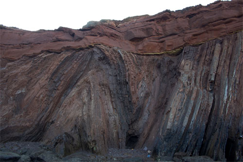
How the continental lithosphere deforms at convergent plate margins has been a matter of opinion that depends on where observations have been made in ancient orogenic belts. One view is that arc and collisional orogens are dominated by deformation of the upper crust and especially the cover of sedimentary and volcanic rocks above deeper and older basement. This is a ‘thin-skinned’ model in which rocks of the upper crust are detached from those below and thicken more or less independently by thrust faulting, the formation of ductile nappes or a combination of the two. Mountain ranges, in this view, are the product of piling up of thrust slices or nappes, as exemplified by the Alps, Canadian Rockies and the Caledonian thrust belt of NW Scotland. Thick-skinned processes, as the name suggests, see crustal shortening and thickening as being distributed through the crust from top to bottom and even involving the lithospheric mantle. The hinterlands of both the Alps and the Scottish Caledonides show plenty of evidence for entire-crust deformation, deep crustal rocks being found sheared together with deformed rocks of the cover. It stands to reason that orogenic processes on the grand scale must involve a bit of both.

Both hypotheses stem from field work in deeply eroded, structurally complex segments of the ancient crust, and it is rarely if ever possible to say whether both operated together or one followed the other during the often lengthy periods taken by orogeny to reach completion, and the sheer scale of the process. Orogenesis is going on today, to which major seismic activity obviously bears witness. But erosion has not progress from cover through basement so, up to now, only seismicity and geodetic GPS measurements have been available to show that continental crust in general is being shortened and thickened, as well as being moved about. Potentially, a means of assessing active deformation, even in the deep crust, is to see whether or not the speeds of seismic waves at different depths are biased depending on their direction of travel. Such anisotropy would develop if the mineral grains making up rocks were deformed and rotated to preferred directions; a feature typical of metamorphic rocks. But to make such measurements on the scale of active orogens requires a dense network of seismometers and software that can tease directionality and depth out of the earthquake motions detected by it.

LS-tectonite from the Paraiba do Sul Shear Zon...
Aligned minerals in a Brazilian metamorphic rock (credit: Eurico Zimbres in Wikipedia)

A joint Taiwanese-American consortium set up such a network in Taiwan, which is capable of this type of seismic tomography. Taiwan is currently taking up a strain rate of 8.2 cm per year due to motion of the Philippine Plate on whose western flank the island lies: it is part of an island arc currently colliding with the stationary Eurasian Plate and whose crust is shortening. Results of seismic anisotropy (Huang, T.-Y. et al. 2015. Layered deformation in the Taiwan orogen. Science, v. 349, p. 720-723) show that the fast direction of shear (S) waves changes abruptly at about 10 to 15 km deep in the crust. In the upper crust this lines up with the roughly N-S structural ‘grain’ of the orogen. At between 13 to 17 km down there is no discernible anisotropy, below which it changes to parallel the direction of plate motion, ESE-WNW. It seems that thin skinned tectonics is indeed taking place, although probably not above a structural detachment. Simultaneously the deep crust is being deformed but the shearing is ascribed to the descent of lithospheric mantle of the Philippine Plate beneath the Eurasian Plate, while the deep crust remains attached to the upper crust. If it were possible to examine the mineral lineations now forming in both the Taiwanese upper and lower crust where metamorphism is active, then the two directions would be apparent. Although not mentioned by the authors, perhaps the detection of different directionality of aligned metamorphic minerals in low- and high-grade metamorphic rocks might indicate such tectonic processes in the past.

When Earth got its magnetic field

For a planet to produce life it needs various attributes. Exoplanet hunters tend to focus on the ‘Goldilocks’ Zone’ where solar heating is neither so extreme nor so little that liquid water is unstable on a planet’s surface. It also needs an atmosphere that retains water. Ultraviolet radiation emitted by a planet’s star dissociates water vapour to hydrogen and oxygen and the hydrogen escapes to space. The reason Earth has not lost water in this way is that little water vapour reaches the stratosphere because it is condensed or frozen out of the air as the lower atmosphere becomes cooler with altitude. Given moist conditions survivability to the extent that exists on Earth still needs another planetary parameter: the charged particles emitted as an interplanetary ‘wind ‘by stars must not reach the surface. If they did, their potential to break complex molecules would hinder life’s formation or wipe it out if it ventured onto land. A moving current of electrical charge, which is what a stellar ‘wind’ amounts to, can be deflected by a magnetic field. This is what happens on Earth, whose magnetic field is a good reason why our planet has supported life and its continual evolution since at least about 3.5 billion years ago.

Artist's rendition of Earth's magnetosphere.
Deflection of the solar ‘wind’ by Earth’s Earth’s magnetosphere. (credit: Wikipedia)

Direct proof of the existence of a geomagnetic field is the presence of aligned particles of magnetic minerals in rocks, for instance in a lava flow, caused by their acquiring magnetisation in a prevailing magnetic field once they cooled sufficiently. The earliest such remanent magnetism was found in igneous rocks from north-eastern South Africa dated at between 3.2 to 3.45 billion years. All older rocks do not show such a feature dating back to their formation because of thermal metamorphism that resets any remanent magnetism to match the geomagnetic field prevailing at the time of reheating. There are, however, materials that formed further back in time and are also known to resist thermal resetting of any alignments of magnetic inclusion. They are zircons (ZrSiO4), originally crystallised from igneous magmas, which may have locked in minute magnetic inclusions. Zircons are among the most change-resistant materials and they can also be dated with great precision, with the advantage that the U-Pb method used can distinguish between age of formation and that of any later heating. Famously, individual grains of zircon that had accumulated in an early Archaean conglomerate outcropping in the Jack Hills of Western Australia yielded ages going back from 3.2 to 4.4 billion years; far beyond the age of any tangible rock and close to the formation age of the Earth. Quite a target for palaeomagnetic investigations once a suitable technique had been developed.

Western Australia's Jack Hills
Western Australia’s Jack Hills from Landsat (credit NASA Earth Observatory)

John Tarduno and colleagues from the Universities of Rochester and California USA and the Geological Survey of Canada report the magnetic properties of the Jack Hills zircons (Tarduno, J.A. et al. 2015. A Hadean to Paleoarchean geodynamo recorded by single zircon crystals. Science, v. 349, p. 521-524). All of the grains analysed record magnetisation spanning the period 3.2 to 4.2 billion years that indicate geomagnetic field strengths ranging from that found today at the Equator to about an eighth of the modern value. So from 4.2 Ga onwards geomagnetism probably deflected the solar wind: the early Earth was set for living processes from its earliest days. The discovery also supports the likelihood of functioning plate tectonics during the Hadean.

How far has geochemistry led geology?


Granite pmg ss 2006
Thin section of a typical granite: clear white and grey grains are quarts (silica); striped black and white is feldspar; coloured minerals are micas (credit: Wikipedia)

In the Solar System the Earth is unique in having a surface split into two distinct categories according to their relative elevation; one covered by water, the other not. More than 60% of its surface – the ocean basins – falls between 2 to 11 km below sea level with a mean around 4 to 5 km deep. A bit less than 40% – land and the continental shelves – stands higher than 1 km below sea level up to almost 9 km above, with a mean around 1 km high. Between 1 and 2 km below sea level is represented by only around 3 % of the surface area. This combined hypsography and wetness is reckoned to have had a massive bearing on the course of climate and biological evolution, as far as allowing our own emergence. The Earth’s bimodal elevation stems from the near-surface rock beneath each division having different densities: continental crust is less dense than its oceanic counterpart, and there is very little crustal rock with an intermediate density. Gravitational equilibrium ensures that continents rise higher than oceans. That continents were underpinned mainly by rocks of granitic composition and density, roughly speaking, was well known by geologists at the close of the 19th century. What lay beneath the oceans didn’t fully emerge until after the advent of plate tectonics and the notion of simple basaltic magmas pouring out as plates became detached.

In 1915 Canadian geologist Norman Levi Bowen resolved previously acquired knowledge of the field relations, mineralogy and, to a much lesser extent, the chemistry of igneous rocks, predominantly those on the continents in a theory to account for the origin of continents. This involved a process of distillation or fractionation in which the high-temperature crystallisation of mafic (magnesium- and iron-rich) minerals from basaltic magma left a residual melt with lower Mg and Fe, higher amounts of alkalis and alkaline earth elements and especially enriched in SiO2 (silica). A basalt with ~50% silica could give rise to rocks of roughly granitic composition (~60% SiO2) – the ‘light’ rocks that buoy-up the continental surface – through Bowen’s hypothetical fractional crystallisation. Later authors in the 1930s, including Bowen’s teacher Reginald Aldworth Daly, came up with the idea that granites may form by basalt magma digesting older SiO2-rich rocks or by partially melting older crustal rocks as suggested by British geologist Herbert Harold Read. But, of course, this merely shifted the formation of silica-rich crust further back in time

A great deal of field, microscope and, more recently, geochemical lab time has been spent since on to-ing and fro-ing between these hypotheses, as well as on the petrology of basaltic magmas since the arrival of plate theory and the discovery of the predominance of basalt beneath ocean floors. By the 1990s one of the main flaws seen in Bowen’s hypothesis was removed, seemingly at a stroke. Surely, if a basalt magma split into a dense Fe- Mg-rich cumulate in the lower crust and a less dense, SiO2-rich residual magma in the upper continental crust the bulk density of that crust ought to remain the same as the original basalt. But if the dense part somehow fell back into the mantle what remained would be more able to float proud. Although a neat idea, outside of proxy indications that such delamination had taken place, it could not be proved.

Since the 1960s geochemical analysis has became steadily easier, quicker and cheaper, using predominantly X-ray fluorescence and mass-spectrometric techniques. So geochemical data steadily caught up with traditional analysis of thin sections of rock using petrological microscopes. Beginning in the late 1960s igneous geochemistry became almost a cottage industry and millions of rocks have been analysed. Recently, about 850 thousand multi-element analyses of igneous rocks have been archived with US NSF funding in the EarthChem library. A group from the US universities of Princeton, California – Los Angeles and Wisconsin – Madison extracted 123 thousand plutonic and 172 thousand volcanic igneous rocks of continental affinities from EarthChem to ‘sledgehammer’ the issue of continent formation into a unified theory (Keller, C.B. et al. 2015. Volcanic-plutonic parity and the differentiation of the continental crust. Nature, v. 523, p. 301-307).

In a nutshell, the authors compared the two divisions in this vast data bank; the superficial volcanic with the deep-crustal plutonic kinds of continental igneous rock. The gist of their approach is a means of comparative igneous geochemistry with an even longer pedigree, which was devised in 1909 by British geologist Alfred Harker. The Harker Diagram plots all other elements against the proportionally most variable major component of igneous rocks, SiO2. If the dominant process involved mixing of basalt magma with or partial melting of older silica-rich rocks such simple plots should approximate straight lines. It turns out – and this is not news to most igneous geochemists with far smaller data sets – that the plots deviate considerably from straight lines. So it seems that old Bowen was right all along, the differing deviations from linearity stemming from subtleties in the process of initial melting of mantle to form basalt and then its fractionation at crustal depths. Keller and colleagues found an unexpected similarity between the plutonic rocks of subduction-related volcanic arcs and those in zones of continental rifting. Both record the influence of water in the process, which lowers the crystallisation temperature of granitic magma so that it freezes before the bulk can migrate to the surface and extrude as lava. Previously. rift-related magmas had been thought to be drier than those formed in arcs so that silica-rich magma should tend to be extruded.

But there is a snag, the EarthChem archive hosts only data from igneous rocks formed in the Phanerozoic, most being less than 100 Ma old. It has long been known that continental crust had formed as far back as 4 billion years ago, and many geologists believe that most of the continental crust was in place by the end of the Precambrian about half a billion years ago. Some even reckon that igneous process may have been fundamentally different before 3 billion years ago(see: Dhuime, B., Wuestefeld, A. & Hawkesworth, C. J. 2015. Emergence of modern continental crust about 3 billion years ago.  Nature Geoscience, v. 8, p.552–555). So big-science data mining may flatter to deceive and leave some novel questions unanswered .


Two happy events for plate tectonics

In an era where fears of rising sea level and loss of land are growing it is a great pleasure to announce (albeit several years late) the birth of two new islands. They emerged close to the axis of the Red Sea in Yemeni territory as new members of the volcanic Zubair Islands during episodic eruptions that began on 18 December 2011. First to form was dubbed Sholan (‘One who is Blessed’ in Arabic – a girl’s name), which ceased to be active a month later. Further submarine volcanism began on 28 September 2013, with another island, Jadid (‘New’ in Arabic – a boy’s name), breaking surface in October 2013. The double event has been described in great detail by geoscientists based at King Abdullah University of Science and Technology, Saudi Arabia (Xu, W. 2015. Birth of two volcanic islands in the southern Red Sea. Nature Communications, DOI: 10.1038/ncomms8104. After rapid growth during their initial eruptive phases both islands underwent significant marine erosion once quiescent, but seem set to remain as part of the Zubair archipelago.

'Before and after' images of the Zubair archipelago in the southern Red Sea. (Left from Bing maps, right (February 2014) from Google Earth)
‘Before and after’ images of the Zubair archipelago in the southern Red Sea. (Left from Bing maps, right (February 2014) from Google Earth)

Analysis of small earthquakes that happened during the islands’ growth together with Interferometric iradar surveys that showed coincident ground movements among the islands suggest that both eruptions took place along an active north-south fracture system, probably part of axial rifting system of the Red Sea. In more detail, magma seems to have moved upwards along N-S fissures similar to those that now show up as dykes cutting lavas on the older islands in the area. The local fracture patterns are oblique to the main Red Sea Rift that trends NNW-SSE, possibly as a result of non-linear stress trajectories in the Arabia-Africa rifting. In almost all respects the volcanism and mechanism of intrusion and effusion closely resemble that reported recently from a terrestrial setting in the nearby Afar Depression. The slow spreading Red Sea Rift rarely manifests itself by volcanism, so these events reveal a previous unsuspected zone of active melting in the mantle beneath the Zubair archipelago.

Two large, reorganised landscapes

Where tectonic processes proceed quickly it is only to be expected that the land surface undergoes dramatic changes and that big features form. Exactly which processes lay behind very striking landforms may have been worked out long ago; or old ideas from the heyday of geomorphology have perhaps lingered longer than they should. Two tectonically active regions that have a long history of study are the Himalaya and Iceland: one a model of long-lived and rapid uplift driven by collisional tectonics; the other likewise, as a product of extension and rapid build-up of flood basalt flows. Major features of both have been shown to be not quite what they seem.
Substantial parts of the India-Asia collision zone contain broad patches of high, low-relief plateaus separated by deeply incised river gorges. In its eastern parts rise 3 of the largest rivers in SE Asia: the Yangtse; the Mekong and the Salween, which flow roughly parallel to the east and south-east for about 1000 km from their sources in the Tibetan Plateau. Their trajectories partly follow some enormous strike-slip fault that accommodated the relative motion of two continent-bearing plates over the last 50 million years. As well as the crustal thickening that attended the collision, vast amounts of uplifted material have been eroded from the three major gorges. Thickening and unloading have been the key to producing the largest tracts of high land on the planet. Yet between the gorges and their many tributaries in the eastern part of the collision zone are many tracts of high land with only moderate relief rather than sharp ridges. Because the Eurasian plate prior to India’s impact might reasonably be expected to have been only moderately high, if not low lying, and with a mature and muted landscape, a long-lived theory has been that these elevated plateaus are uplifted relics of this former landscape that were dissected by progressively deepening river incision. Much the same idea has been applied to similar mega features, and even coincident peaks in more completely eroded highlands.

Drainage basins of the Yangtse, Mekong and Salween rivers, with low-relief surfaces in buff and cream. Figure 1 in Yang et al. 2015 (credit: Nature)

In the India-Asian collision zone the supposedly ‘relic’ plateaus have been used to reconstruct the pre-collision land surface and the degree of bulging it has undergone since. However, the advent of accurate digital terrain elevation data has enabled the modelling of not only the large rivers but also of the tributary streams that make up major drainage. As well as the directional aspects of drainages their along-channel slopes can be analysed (Yong, R. et al. 2015. In situ low-relief landscape formation as a result of river network disruption. Nature, v. 520, p. 526-529). Rong Yang of the Swiss Federal Institute of Technology and colleagues from the same department and Ben-Gurion University of the Negev, Israel have been able to show that matters are far more complex than once believed. The tributary drainages of the Yangtse, Mekong and Salween gorges appear to have been repeatedly been disrupted by the complexities of deformation. One important factor has been drainage capture or piracy, in which drainages with greater energy erode towards the heads of their catchments until they intercept a major drainage in another sub-basin, thereby ‘stealing’ the energy of the water that it carries. The ‘pirate’ stream then erodes more powerfully in its lower reaches, whereas the basin burgled of much of its energy becomes more sluggishly evolving thereafter and increasingly left anomalous high in the regional terrain: it evolves to liken what previously it had been supposed to be – a relic of the pre-collision landscape.
Many of the rivers in Iceland occupy gorges that contain a succession of large waterfalls. Upstream of each is a wide rock terrace, and downstream the gorge is eroded into such a terrace. Much of Iceland is composed of lava flows piled one above another, as befits the only substantial land that straddles a constructive plate margin – the mid-Atlantic Ridge. Being famous also for its substantial ice caps that are relics of one far larger during the last glacial maximum, it has proved irresistible for geomorphologists to assign the gorge-fall-terrace repetition to gradual uplift due to isostatic rebound as the former ice cap melted and unloaded the underlying lithosphere. As relative sea-level fell each river gained more gravitational potential energy to cut back up its channel, which resulted in a succession of upstream migrating waterfalls and gorges below them. Individual lava flows, being highly resistant to abrasion cease to be affected once cut by a gorge; hence the terraces. But it is now possible to establish the date when each terrace first became exposed to cosmic-ray bombardment, using the amount of cosmogenic 3He that has accumulated in the basalts that form the terrace surfaces (Baynes, E.R. et al. 2015. Erosion during extreme flood events dominates Holocene canyon evolution in northeast Iceland. Proceedings of the National Academy of Science, doi:10.1073/pnas.1415443112).

Valley of Jökulsá á Fjöllum past Dettifoss, Jö...
Gorge incised in basalt flows, Jökulsárgljúfur National Park, Iceland (credit: Wikipedia)

The British-German team from the University of Edinburgh and Deutsches GeoForschungsZentrum, Potsdam worked on terraces of the Jökulsárgljúfur canyon, discovering that three terraces formed abruptly in the Holocene, at 9, 5 and 2 ka ago, with no evidence for any gradual erosion by abrasion. Each terrace was cut suddenly, probably aided by the highly jointed nature of the overlying lava flow that would encourage toppling of blocks given sufficient energy. The team suggests that each represents not stages in uplift, but individual megafloods, perhaps caused by catastrophic glacial melting during subglacial eruptions or failures of dams formed by moraines or ice lobes.

Glacial cycles and sea-floor spreading

The London Review of Books recently published a lengthy review (Godfrey-Smith, P. 2015. The Ant and the Steam Engine. London Review of Books, v. 37, 19 February 2015 issue, p. 18-20) of the latest contribution to Earth System Science by James Lovelock, the man who almost singlehandedly created that popular paradigm through his Gaia concept of a self-regulating Earth (Lovelock, J. A Rough Ride to the Future. Allen Lane: London; ISBN 978 0 241 00476 0). Coincidentally, on 5 February 2015 Science published online a startling account of the inner-outer-inner synergism of Earth processes and climate (Crowley, J.W. et al. 2015. Glacial cycles drive variations in the production of oceanic crust. Science doi:10.1126/science.1261508). In fact serendipity struck twice: the following day a similar online article appeared in a leading geophysics journal (Tolstoy, M. 2015. Mid-ocean ridge eruptions as a climate valve. Geophysical Research Letters, doi:10.1002/2014GL063015)

Both articles centred on the most common topographic features on the ocean floor, abyssal hills. These linear features trend parallel to seafloor spreading centres and the magnetic stripes, which chart the progressive additions to oceanic lithosphere at constructive margins. Abyssal hills are most common around intermediate- and fast-spreading ridges and have been widely regarded as fault-tilt blocks resulting from extensional forces where cooling of the lithosphere causes it to sag towards the abyssal plains. However, some have suggested a possible link with variations in magma production beneath ridge axes as pressure due to seawater depth varied with rising and falling sea level through repeated glacial cycles. Mantle melting beneath ridges results from depressurization of rising asthenosphere: so-called ‘adiabatic’ melting. Pressure changes equivalent to sea-level fluctuations of around 100-130 m should theoretically have an effect on magma productivity, falls resulting in additional volumes of lava erupted on the ocean floor and thus bathymetric highs.

English: A close-up showing mid-ocean ridge to...
Formation of mid-ocean ridge topography, including abyssal hills that parallel the ridge axis. (credit: Wikipedia)

A test of this hypothesis would be see how the elevation of the sea floor adjacent to spreading axes changes with the age of the underlying crust. John Crowley and colleagues from Oxford and Harvard Universities and the Korea Polar Research Institute analysed new bathymetry across the Australian-Antarctic Ridge, whereas Maya Tolstoy of Columbia University performed similar work across the Southern East Pacific Rise. In both studies frequency analysis of changes in bathymetry through time, as calibrated by local magnetic stripes, showed significant peaks at roughly 23, 41 and 100 ka in the first study and at 100 ka in the second. These correspond to the well known Milankovitch periods due to precession, changing axial tilt and orbital eccentricity: persuasive support for a glacial control over mid-ocean ridge magmatism.

Enlarged by 100% & sharpened file with IrfanView.
Periodicities of astronomical forcing and global climate over the last million years (credit: Wikipedia)

An interesting corollary of the observations may be that pulses in sea-floor eruption rates emit additional carbon dioxide, which eventually percolates through the ocean to add to its atmospheric concentration, which would result in climatic warming. The maximum effect would correspond to glacial maxima when sea level reached its lowest, the reduction in pressure stimulating the greatest magmatism. One of the puzzling features of glacial cycles over the last million years, when the 100 ka eccentricity signal dominates, is the marked asymmetry of the sea-level record; slowly declining to a glacial maximum and then a rapid rise due to warming and melting as the Earth changed to interglacial conditions. Atmospheric CO2 concentrations recorded by bubbles in polar ice cores show a close correlation with sea-level change indicated by oxygen isotope data from oceanic sediments. So it is possible that build-up of polar ice caps in a roundabout way eventually reverse cooling once they reach their greatest thickness and extents, by modulating ocean-ridge volcanism and thereby the greenhouse effect.

January 2015 photo of the month

Angular unconformity on the coast of Portugal at Telheiro Beach (credit: Gabriela Bruno)
Angular unconformity at Telheiro Beach, Portugal (credit: Gabriela Bruno)

This image posted at Earth Science Picture of the Day would be hard to beat as the definitive angular unconformity. It shows Upper Carboniferous  marine metagreywackes folded during the Variscan orogeny overlain by Triassic redbeds. Structurally it is uncannily similar to Hutton‘s famous unconformity at Siccar Point on the coast of SE Scotland, although the tight folding there is Caledonian in age and the unconformable redbeds are Devonian in age.

Judging earthquake risk

The early 21st century seems to have been plagued by very powerful earthquakes: 217 greater than Magnitude 7.0; 19 > Magnitude 8.0 and 2 >Magnitude 9.0. Although some lesser seismic events kill, those above M 7.0 have a far greater potential for fatal consequences. Over 700 thousand people have died from their effects: ~20 000 in the 2001 Gujarat earthquake (M 7.7); ~29 000 in 2003 Bam earthquake (M 6.6); ~250 000 in the 2004 Indian Ocean tsunami that stemmed from a M 9.1 earthquake off western Sumatra; ~95 000 in the 2005 Kashmir earthquake (M7.6); ~87 000 in the 2008 Sichuan earthquake (M 7.9); up to 316 000 in the 2010 Haiti earthquake (M 7.0); ~20 000 in the 2011 tsunami that hit NE Japan from the M 9.0 Tohoku earthquake. The 26 December 2004 Indian Ocean tsunamis spelled out the far-reaching risk to populated coastal areas that face oceans prone to seismicity or large coastal landslips, but also the need for warning systems: tsunamis travel far more slowly than seismic waves and , except for directly adjacent areas, there is good chance of escape given a timely alert. Yet, historically http://earthquake.usgs.gov/earthquakes/world/most_destructive.php, deadly risk is most often posed by earthquakes that occur beneath densely populated continental crust. Note that the most publicised earthquake that hit San Francisco in 1906 (at M 7.8) that lies on the world’s best-known fault, the San Andreas, caused between 700 and 3000 fatalities, a sizable proportion of which resulted from the subsequent fire. For continental earthquakes the biggest factor in deadly risk, outside of population density, is that of building standards.

English: A poor neighbourhood shows the damage...
A poor neighbourhood in Port au Prince, Haiti following the 2010 earthquake measuring >7 on the Richter scale. (credit: Wikipedia)

It barely needs stating that earthquakes are due to movement on faults, and these can leave distinct signs at or near to the surface, such as scarps, offsets of linear features such as roads, and broad rises or falls in the land surface. However, if they are due to faulting that does not break the surface – so-called ‘blind’ faults – very little record is left for geologists to analyse. But if it is possible to see actual breaks and shifts exposed by shallow excavations through geologically young materials, as in road cuts or trenches, then it is possible to work out an actual history of movements and their dimensions. It has also become increasingly possible to date the movements precisely using radiometric or luminescence means: a key element in establishing seismic risk is the historic frequency of events on active faults. Some of the most dangerous active faults are those at mountain fronts, such as the Himalaya and the American cordilleras, which often take the form of surface-breaking thrusts that are relative easy to analyse, although little work has been done to date. A notable study is on the West Andean Thrust that breaks cover east of Chile’s capital Santiago with a population of around 6 million (Vargas, G. Et al. 2014. Probing large intraplate earthquakes at the west flank of the Andes. Geology, v. 42, p. 1083-1086). This fault forms a prominent series of scarps in Santiago’s eastern suburbs, but for most of its length along the Andean Front it is ‘blind’. The last highly destructive on-shore earthquake in western South America was due to thrust movement that devastated the western Argentinean city of Mendoza in 1861. But the potential for large intraplate earthquakes is high along the entire west flank of the Andes.

Vargas and colleagues from France and the US excavated a 5 m deep trench through alluvium and colluvium over a distance of 25 m across one of the scarps associated with the San Ramon Thrust. They found excellent evidence of metre-sized displacement of some prominent units within the young sediments, sufficient to detect the effects of two distinct, major earthquakes, each producing horizontal shifts of up to 5 m. Individual sediment strata were dateable using radiocarbon and optically stimulated luminescence techniques. The earlier displacement occurred at around 17-19 ka and the second at about 8 ka. Various methods of estimation of the likely earthquake magnitudes of the displacements yielded values of about M 7.2 to 7.5 for both. That is quite sufficient for devastation of now nearby Santiago and, worryingly, another movement may be likely in the foreseeable future.

Basin and Range: From mountains to basin

The "marching caterpillars" of the Basin and Range province, showing the San Andreas Fault in  (credit: University of Maryland, USA)
The “marching caterpillars” of the Basin and Range province, showing the San Andreas Fault in green (credit: University of Maryland, USA)

The Basin and Range province of the western US is one of the world’s largest products of continental extension. Being semi-arid, sedimentation has been unable to keep pace with crustal thinning thereby giving form to its name: linear mountain ridges separated by sediment-filled basins. Despite the extreme extension the Basin and Range has an average elevation of about 1400 m, although it is well below that of the Sierra Nevada range (2000+ m) that flanks it to the west. Throughout the Mesozoic, subduction towards the east beneath the North American plate produced voluminous magmas and fold-thrust belts adding to the continental crust in a manner similar to that still occurring in the South American Andes. Extension began in earnest during the Eocene (~45 Ma) and continues today. Much of the theory regarding continental extension – listric normal faults and detachments, fault-tilt blocks, core complexes etc. – stems from studies in this huge terrain. As regards the evolution of the Basin and Range, it has been widely thought that by the Late Oligocene (~25 Ma) the thickened Cordilleran crust had been reduced to a plateau no higher than the present Sierra Nevada, which subsequent extension reduced to the present Basin and Range.

The Eocene to Miocene extensional history was punctuated by huge episodes of explosive volcanism from which hot ash flowed laterally for hundreds of kilometres, relics of which are still widespread. Such ignimbrites are often very porous and were aquifers while still exposed, until buried by sediment and subsequent nuée ardent flows. Groundwater at the time of first exposure altered the volcanic glass shards from which ignimbrites are formed, so that the oxygen and hydrogen making up what was originally rainwater is now locked in the altered ash flows. The hydrogen isotopic composition of such meteoric water is known to vary with the altitude of the clouds shedding it. Water containing the heavier hydrogen isotope deuterium (D) is preferentially precipitated at low altitudes, so that high altitude rainfall is significantly depleted in it. Because of this the alteration can give clues to the former topographic elevation of the ignimbrites when they first rushed across the land surface. Applying this method to the repeated ignimbrite events in what is now the Basin and Range has given a good idea of the actual evolution of the land surface in the western US during the Palaeogene (Cassel, E.J. et al. 2014. Profile of a paleo-orogen: high topography across the present-day Basin and Range from 40-23 Ma. Geology, v. 42, p. 1007-1010).

The results present a major surprise. In the Eocene, elevation across the area was, as anticipated, a little more than the present Sierra Nevada (2000-2500 m). This fell back to roughly 2000 m, again as theory would suggest. But by the Late Oligocene (23-27 Ma) elevation expected to have declined further over the Basin and Range actually leapt to between 2500-3500 m, up to 2.1 km higher than it is today: the opposite of prediction. Effectively, despite evidence for Palaeogene extension the crust was buoyed-up probably by an upwelling of the asthenosphere and increased heat flow. The unexpected uplift occurred towards the end of subduction of oceanic lithosphere beneath western North America, the dynamics of which prevented the westward collapse of an earlier orogen. When subduction ended and the plate-margin tectonics became strike slip, as witnessed by the San Andreas Fault, the continental crust slid apart in the manner of books on a library shelf if a bookend is removed.

Johnson, S.K. 2015. From rain to ranges. Scientific American, v. 312 (January 2015), p. 12-13.

New gravity and bathymetric maps of the oceans

By far the least costly means of surveying the ocean floor on a global scale is the use of data remotely sensed from Earth orbit. That may sound absurd: how can it be possible to peer through thousands of metres of seawater? The answer comes from a practical application of lateral thinking. As well as being influenced by lunar and solar tidal attraction, sea level also depends on the Earth’s gravity field; that is, on the distribution of mass beneath the sea surface – how deep the water is and on varying density of rocks that lie beneath the sea floor. Water having a low density, the deeper it is the lower the overall gravitational attraction, and vice versa. Consequently, seawater is attracted towards shallower areas, standing high over, say, a seamount and low over the abyssal plains and trenches. Measuring sea-surface elevation defines the true shape that Earth would take if the entire surface was covered by water – the geoid – and is both a key to variations in gravity over the oceans and to bathymetry.

Radar altimeters can measure the average height of the sea surface to within a couple of centimetres: the roughness and tidal fluctuations are ‘ironed out’ by measurements every couple of weeks as the satellite passes on a regular orbital schedule. There is absolutely no way this systematic and highly accurate approach could be achieved by ship-borne bathymetric or gravity measurements, although such surveys help check the results from radar altimetry over widely spaced transects. Even after 40 years of accurate mapping with hundreds of ship-borne echo sounders 50% of the ocean floor is more than 10 km from such a depth measurement (80% lacks depth soundings)

This approach has been used since the first radar altimeter was placed in orbit on Seasat, launched in 1978, which revolutionised bathymetry and the details of plate tectonic features on the ocean floor. Since then, improvements in measurements of sea-surface elevation and the computer processing needed to extract the information from complex radar data have show more detail. The latest refinement stems from two satellites, NASA’s Jason-1(2001) and the European Space Agency’s Cryosat-2 (2010) (Sandwell, D.T. et al. 2014. New global marine gravity model from CryoSat-2 and Jason-1 reveals buried tectonic structure. Science, v. 346. p. 65-67; see also Hwang, C & Chang, E.T.Y. 2014. Seafloor secrets revealed. Science, v. 346. p. 32-33). If you have Google Earth you can view the marine gravity data by clicking here.  The maps throw light on previously unknown tectonic features beneath the China Sea (large faults buried by sediments), the Gulf of Mexico (an extinct spreading centre) and the South Atlantic (a major propagating rift) as well as thousands of seamounts.

Global gravity over the oceans derived from Jason-1 and Cryosat-2 radar altimetry (credit: Scripps Institution of Oceanography)

There are many ways of processing the data, and so years of fruitful interpretation lie ahead of oceanographers and tectonicians, with more data likely from other suitably equipped satellites: sea-surface height studies are also essential in mapping changing surface currents, variations in water density and salinity, sea-ice thickness, eddies, superswells and changes due to processes linked to El Niño.