Hominins have been making and using stone tools since at least 3.4 Ma, as shown by cut marks on bones and stone artefacts themselves. I use the sack term ‘hominin’ because the likely makers and users of the oldest tools are either australopithecines or paranthropoids, there being no fossils designates to the genus Homo of late-Pliocene age. So it might seem un-newsworthy to report that the oldest tools deliberately made from bone are now known to occur in 1.5 Ma old sediments from the famous sedimentary sequence at Olduvai Gorge in Tanzania (de la Torre, I and 8 others2025. Systematic bone tool production at 1.5 million years ago. Nature, v. 639; DOI: 10.1038/s41586-025-08652-5). To be clear, there is abundant evidence that hominins had used bones, especially sturdy long bones, for digging perhaps, much earlier in hominin history. Again, paranthropoids have been implicated in their use. The bones found at Olduvai actually show signs of manufacture into useful objects prior to their use: they show clear signs of knapping to produce points and blades. The bones are among the sturdiest known from the Pleistocene, being from elephants and hippos. Before de la Torre and colleagues found what is essentially a bone-tool factory, it was thought that systematic use of bones in such a sophisticated manner only arose between 400 to 250 ka ago among early Homo in Europe. Sadly, fossils of whoever made the tools were not found at the site. Once again, paranthropoids as well as early Homo are known to have cohabited the area at that time.
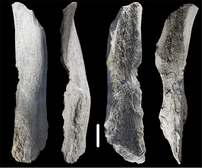
‘Front, back and side’ views of a 1.5 Ma old tool made from an elephant humerus – its upper foreleg. The scale bar represents 5 cm. (Credit: de la Torre et al.; Fig 3a)
Bifacial Acheulean stone artefacts first appear in the rock record about 300 ka before these bone tools were made. So one idea that the authors put forward is that the same kind of stone knapping technique was transferred to the more abundant massive bones of the East African Pleistocene megafauna (in the absence or rarity of suitable blocks of stone?). But it remains unclear whether or not such tools were simply selected from very large bones smashed to get at their nutritious marrow. The first possibility implies a cultural shift, whereas the latter points simply to expedience. The authors are at pains to point out that the curious million-year gap in the record of bone tools may be ascribed either to the disappearance of bone technology or simply to archaeologists who worked elsewhere having not regarding bone fragments as the products of skills. That applies equally to earlier times, when bones were indeed used, though with not so much in the way of a ‘mental template’. As de la Torre et al. conclude ‘Future research needs to investigate whether similar bone tools were already produced in earlier times, persisted during the Acheulean and eventually evolved into Middle Pleistocene bone bifaces similar in shape, size and technology to their stone counterparts’.
Evidence from Dmanisi in Georgia that Homo erectus may have been the first advanced hominin to leave Africa about 1.8 Ma ago was a big surprise (see: First out of Africa?November 2003). Remains of five individuals included one skull of an aged person who face was so deformed that he or she must have been cared for by others for many years. So, a second surprise from Dmanisi was that human empathy arose far earlier than most people believed. Since 2002 there has been only a single further find of hominin bones of such antiquity, at Longgudong in central China. For the period between 1.0 and 2.0 Ma eight other sites in Eurasia have yielded hominin remains. If finds of stone tools and evidence of deliberate butchery – cut marks on prey animals’ bones – are accepted as tell-tale signs, the Eurasian hominin record is considerably larger, and longer,. There are 11 Eurasian sites that have yielded such evidence – but no hominin remains – that are older than Longgudong: in Russia, China, the Middle East, North Africa and northern India. The oldest, at Masol in northern India is 2.6 Ma old. In January 2025 the earliest European evidence for hominin activity was reported from Grăunceanu in Romania (Curran, S.C. and 15 others 2025. Hominin presence in Eurasia by at least 1.95 million years ago. Nature Communications, v. 16, article 836; DOI: 10.1038/s41467-025-56154-9) in the form of animal bones showing clear signs of butchery, as well as stone tools, but no hominin fossils.
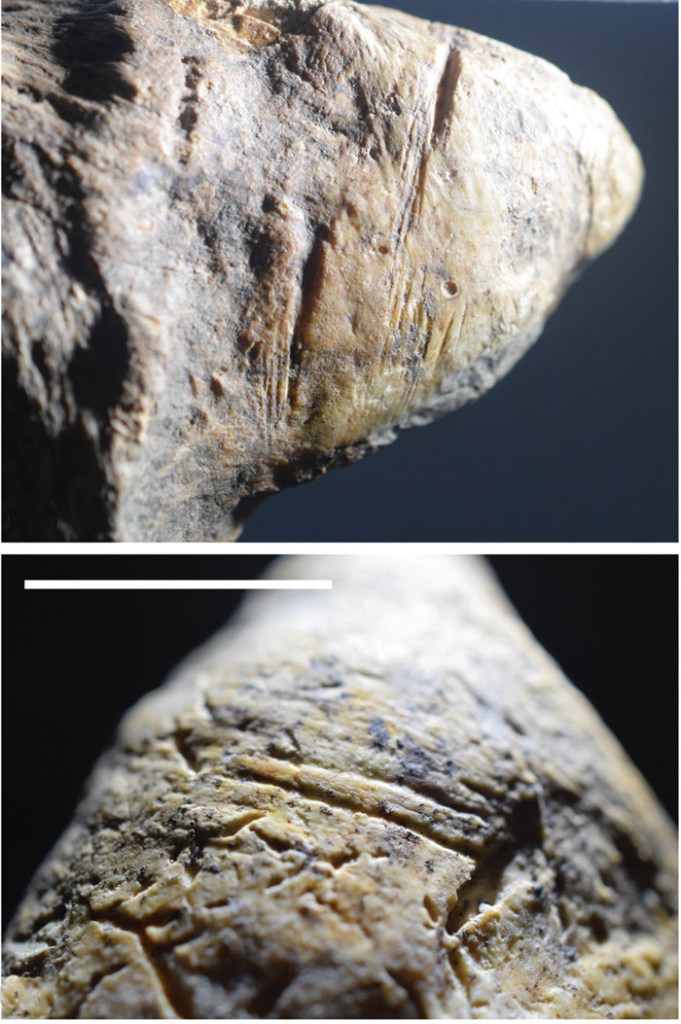
Animal bones showing cut marks from the 1.95 Ma old Grăunceanu site in Romania. (Credit: Curran et al. 2025, Figs 2A and C)
There were stone-tool makers who butchered prey in Africa as early as 3.4 Ma ago (see: Stone tools go even further back; May 2015), but without direct evidence of which hominin was involved. Several possible candidates have been suggested: Australopithecus; Kenyanthropus; Paranthropus. The earliest known African remains of H. erectus have been dated at around 2.0 Ma. So, all that can be said with some certainty about the pre-2 Ma migrants to Eurasia, until fossils of that antiquity are found, is that they were hominins of some kind: maybe advanced australopithecines, paranthropoids or early humans. Those from Longgudong and Dmanisi probably are early Homo erectus, and 2 others (1.7 and 1.6 Ma) from China have been designated similarly. Younger, pre-1.0 Ma Eurasian hominins from Israel, Indonesia, Spain and Turkey are currently un-named at the species level, but are allegedly members of the genus Homo.
So, what can be teased from the early Eurasian hominin finds? Some certainly travelled thousands of kilometres from their assumed origins in Africa, but none penetrated further north than about 50°N. Perhaps they could not cope with winters at higher latitudes, especially during ice ages. To reach as far as eastern and western Eurasia suggests that dispersal following exit from Africa would have taken many generations. There is no reason to suppose continual travel; rather the reverse, staying put in areas with abundant resources while they remained available, and then moving on when they became scarce. Climate cycles, first paced at around 40 ka (early Pleistocene) then at around 100 ka (mid Pleistocene and later), would have been the main drivers for hominin population movements, as it would have been for game and vegetation.
After about 3 Ma the 40 ka climate cyclicity evolved to greater differences in global temperature between glacial and interglacial episodes, and even more so after the mid Pleistocene transition to 100 ka cycles (see Wikipedia entry for the mid-Pleistocene Transition). Thus, it seems likely that chances of survival of dispersed bands of hominins decreased over hundreds of millennia. Could populations have survived in particularly favourable areas; i.e. those at low latitudes? If so did both culture and the hominins themselves evolve? Alternatively, was migration in a series of pulses out of Africa and then dispersal in all directions, most ending in regional extinction? Almost certainly, pressures to leave Africa would have been driven by climate, for instance by increased aridity as global temperatures waned and sea-level falls made travel to Eurasia easier. There may also have been secondary, shorter migrations within Eurasia, again driven by environmental changes. Without more data from newly discovered sites we can go little further. Within the 35 known, pre-1 Ma hominin sites there are two clusters: southern and central China, and the Levant, Turkey and Georgia. Could they yield more developments? A 2016 article in Scientific American about Chinese H. erectus finds makes particularly interesting reading in this regard.
Neanderthals and the elusive Denisovans began to establish permanent Eurasian ranges, after roughly 600 ka ago. Both groups survived until after first contact with waves of anatomically modern humans in the last 100 ka, with whom some interbred before vanishing from the record. However, evidence from the DNA of both groups suggests an interesting possibility. Before the two groups split genetically, their common ancestors (H. heidelbergensis or H. antecessor?) apparently interbred with genetically more ancient Eurasian hominins (see Wikipedia entry for Neanderthal evolution). This intriguing hint suggests that more may be discovered when substantial remains of Denisovans – i.e. more than a few teeth and small bones – are discovered and yield more DNA. My guess is such a future development will stem from analysis of early hominin remains in China, currently regarded as H. erectus. See China discovers landmark human evolution fossils. Xinhua News Agency 9 December 2024)
A fully revised edition of Steve Drury’s book Stepping Stones: The Making of Our Home World can now be downloaded as a free eBook
Refugees from the Middle East migrating through Slovenia in 2015. Credit: Britannica
During the Pliocene (5.3 to 2.7 Ma) there evolved a network of various hominins, with their remains scattered across both the northern and southern parts of that continent. The earliest, though somewhat disputed hominin fossil Sahelanthropus tchadensis hails from northern Chad and lived around 7 Ma ago, during the late Miocene, as did a similarly disputed creature from Kenya Orrorin tugenensis (~5.8 Ma). The two were geographically separated by 1500 km, what is now the Sahara desert and the East African Rift System. The suggestion from mtDNA evidence that humans and chimpanzees had a common ancestor, the uncertainty about when it lived (between 13 to 5 Ma) and what it may have looked like, let alone where it lived, makes the notion debateable. There is even a possibility that the common ancestor of humans and the other anthropoid apes may have been European. Its descendants could well have crossed to North Africa when the Mediterranean Sea had been evaporated away to form the thick salt deposits that now lie beneath it: what could be termed the ‘Into Africa’ hypothesis. The better known Pliocene hominins were also widely distributed in the east and south of the African continent. Wandering around was clearly a hominin predilection from their outset. The same can be said about humans in the general sense (genus Homo) during the Early Pleistocene when some of them left Africa for Eurasia. Artifacts dated at 2.1 Ma have been found on the Loess Plateau of western China, and Georgia hosts the earliest human remains known from Eurasia. Since them H. antecessor, heidelbergensis, Neanderthals and Denisovans roamed Eurasia. Then, after about 130 ka, anatomically modern humans progressively populated all continents, except Antarctica, to their geographic extremities and from sea level to 4 km above it.
There is a popular view that curiosity and exploration are endemic and perhaps unique to the human line: ‘It’s in our genes’. But even plants migrate, as do all animal species. So it is best to be wary of a kind of hominin exceptionalism or superior motive force. Before settled agriculture, simply diffusion of populations in search of sustenance could have achieved the enormous migrations undertaken by all hominins: biological resources move and hunter gatherers follow them. The first migration of Homo erectus from Africa to northern China by way of Georgia seems to taken 200 ka at most and covered about ten thousand kilometres: on average a speed of only 50 m per year! That achievement and many others before and later were interwoven with the evolution of brain size, cognitive ability, means of communication and culture. But what were the ultimate drivers? Two recent papers in the journal Nature Communications make empirically-based cases for natural forces driving the movement of people and changes in demography.
The first considers hominin dispersal in the Palaearctic biogeographic realm: the largest of eight originally proposed by Alfred Russel Wallace in the late 19th century that encompasses the whole of Eurasia and North Africa (Zan, J. et al. 2024. Mid-Pleistocene aridity and landscape shifts promoted Palearctic hominin dispersals. Nature Communications, v. 15, article 10279; DOI: 10.1038/s41467-024-54767-0). The Palearctic comprises a wide range of ecosystems: arid to wet, tropical to arctic. After 2 Ma ago, hominins moved to all its parts several times. The approach followed by Zan et al. is to assess the 3.6 Ma record of the thick deposits of dust carried by the perpetual westerly winds that cross Central Asia. This gave rise to the huge (635,000 km2) Loess Plateau. At least 17 separate soil layers in the loess have yielded artefacts during the last 2.1 Ma. The authors radiocarbon dated the successive layers of loess in Tajikistan (286 samples) and the Tarim Basin (244 samples) as precisely as possible, achieving time resolutions of 5 to 10 ka and 10 to 20 ka respectively. To judge variations in climate in these area they also measured the carbon isotopic proportions in organic materials preserved within the layers. Another climate-linked metric that Zan et al. is a time series showing the development of river terraces across Eurasia derived from the earlier work of many geomorphologists. The results from those studies are linked to variations through time in the numbers of archaeological sites across Eurasia that have yielded hominin fossils, stone tools and signs of tool manufacture, many of which have been dated accurately.
The authors use sophisticated statistics to find correlations between times of climatic change and the signs of hominin occupation. Episodes of desertification in Palaearctic Eurasia clearly hindered hominins’ spreading across the continent either from west to east of vice versa. But there were distinct, periodic windows of climatic opportunity for that to happen that coincide with interglacial episodes, whose frequency changed at the Mid Pleistocene Transition (MPT) from about 41 ka to roughly every 100 ka. That was suggested in 2021 to have arisen from an increased roughness of the rock surface over which the great ice sheets of the Northern Hemisphere moved. This suppressed the pace of ice movement so that the 41 ka changes in the tilt of the Earth’s rotational axis could no longer drive climate change during the later Pleistocene, despite the fact that the same astronomical influence continued. The succeeding ~100 ka pulsation may or may not have been paced by the very much weaker influence of Earth changing orbital eccentricity. Whichever, after the MPT climate changes became much more extreme, making human dispersal in the Palearctic realm more problematic. Rather than hominin’s evolution driving them to a ‘Manifest Destiny’ of dominating the world vastly larger and wider inorganic forces corralled and released them so that, eventually, they did.
Much the same conclusion, it seems to me, emerges from a second study that covers the period since ~ 9 ka ago when anatomically modern humans transitioned from a globally dominant hunter-gatherer culture to one of ‘managing’ and dominating ecosystems, physical resources and ultimately the planet itself. (Wirtz, K.W et al. 2024. Multicentennial cycles in continental demography synchronous with solar activity and climate stability. Nature Communications, v. 15, article 10248; DOI: 10.1038/s41467-024-54474-w). Like Zan et al., Kai Wirtz and colleagues from Germany, Ukraine and Ireland base their findings on a vast accumulated number (~180,000) of radiocarbon dates from Holocene archaeological sites from all inhabited continents. The greatest number (>90,000) are from Europe. The authors applied statistical methods to judge human population variations since 11.7 ka in each continental area. Known sites are probably significantly outweighed by signs of human presence that remain hidden, and the diligence of surveys varies from country to country and continent to continent: Britain, the Netherlands and Southern Scandinavia are by far the best surveyed. Given those caveats, clearly this approach gives only a blurred estimate of population dynamics during the Holocene. Nonetheless the data are very interesting.
The changes in population growth rates show distinct cyclicity during the Holocene, which Wirtz et al. suggest are signs of booms and busts in population on all six continents. Matching these records against a large number of climatic time series reveals a correlation. Their chosen metric is variation in solar irradiance: the power per unit area received from the Sun. That has been directly monitored only over a couple of centuries. But ice cores and tree rings contain proxies for solar irradiance in the proportions of the radioactive isotopes 10Be and 14C contained in them respectively. Both are produced by the solar wind of high-energy charged particles (electrons, protons and helium nuclei or alpha particles) penetrating the upper atmosphere. The two isotopes have half-lives long enough for them to remain undecayed and thus detectable for tens of thousand years. Both ice cores and tree rings have decadal to annual time resolutions. Wirtz et al. find that their crude estimates of booms and busts in human populations during the Holocene seem closely to match variations in solar activity measured in this way. Climate stability favours successful subsistence and thus growth in populations. Variable climatic conditions seem to induce subsistence failures and increase mortality, probably through malnutrition.
A nice dialectic clearly emerges from these studies. ‘Boom and bust’ as regards populations in millennial and centennial to decadal terms stem from climate variations. Such cyclical change thus repeatedly hones natural selection among the survivors, both genetically and culturally, increasing their general fitness to their surroundings. Karl Marx and Friedrich Engels would have devoured these data avidly had they emerged in the 19th century. I’m sure they would have suggested from the evidence that something could go badly wrong – negation of negation, if readers care to explore that dialectical law further . . . And indeed that is happening. Humans made ecologically very fit indeed in surviving natural pressures are now stoking up a major climatic hiccup, or rather the culture and institutions that humans have evolved are doing that.
Both physical and chemical weathering reflects climatic controls. Erosion is effectively climate in continuous action on the Earth’s solid surface through water, air and bodies of ice moving under the influence of gravity. These two major processes on the land surface are immensely complicated. Being the surface part of the rock cycle, they interact with biological processes in the continents’ web of climate-controlled ecosystems. It is self-evident that climate exerts a powerful influence on all terrestrial landforms. But at any place on the Earth’s surface climate changes on a whole spectrum of rates and time scales as reflected by palaeoclimatology. With little room for doubt, so too do weathering and erosion. Yet other forces are at play in the development of landforms. ‘Wearing-down’ of elevated areas removes part of the load that the lithosphere bears, so that the surface rises in deeply eroded terrains. Solids removed as sediments depress the lithosphere where they are deposited in great sedimentary basins. In both cases the lithosphere rises and falls to maintain isostatic balance. On the grandest of scales, plate tectonics operates continuously as well. Its lateral motions force up mountain belts and volcanic chains, and drag apart the lithosphere, events that in themselves change climate at regional levels. Tectonics thereby creates ‘blips’ in long term global climate change. So evidence for links between landform evolution and palaeoclimate is notoriously difficult to pin down, let alone analyse.
The evidence for climate change over the last few million years is astonishingly detailed; so much so that it is possible to detect major global events that took as little as a few decades, such as the Younger Dryas, especially using data from ice cores. The record from ocean-floor sediments is good for changes over hundreds to thousands of years. The triumph of palaeoclimatology is that the last 2.5 Ma of Earth’s history has been proved to have been largely paced by variations in the Earth’s orbit and in the angle of tilt and wobbles of its rotational axis: a topic that Earth-logs has tracked since the start of the 21st century. The record also hints at processes influencing global climate that stem from various processes in the Earth system itself, at irregular but roughly millennial scales. The same cannot be said for the geological record of erosion, for a variety of reasons, foremost being that erosion and sediment transport are rarely continuous in any one place and it is more difficult to date the sedimentary products of erosion than ice cores and laminations in ocean-floor sediments. Nonetheless, a team from the US, Germany, the Netherlands , France and Argentina have tackled this thorny issue on the eastern side of the Andes in Argentina (Fisher, G.B. and 11 others 2023. Milankovitch-paced erosion in the southern Central Andes. Nature Communications, v. 14, 424-439; DOI: 10.1038/s41467-023-36022-0.
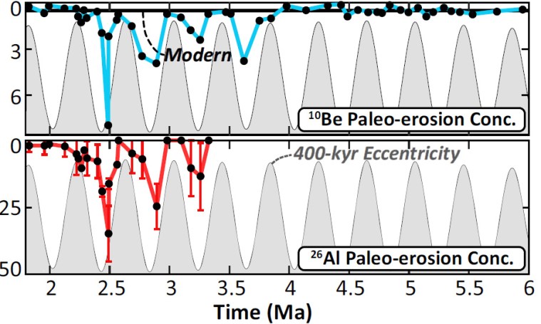
Burch Fisher (University of Texas at Austin, USA) and colleagues studied sediments derived from a catchment that drains the Puna Plateau that together with the Altiplano forms the axis of the Central Andes. In the late 19th century the upper reaches of the Rio Iruya were rerouted, which has resulted in its cutting a 100 m deep canyon through Pliocene to Early Pleistocene (6.0 to 1.8 Ma) sediments. The section includes six volcanic ash beds (dated precisely using the zircon U-Pb method) and records nine palaeomagnetic reversals, which together helped to calibrate more closely spaced dating. Their detailed survey used the decay of radioactive isotopes of beryllium and aluminium (10Be and 26Al) in quartz grains that form in the mineral when exposed at the surface to cosmic-ray bombardment. Such cosmogenic radionuclide dating thus records the last time different sediment levels were at the surface, presumably when the sediment was buried, and thus the variation in the rate of sediment supply from erosion of the Rio Iruya catchment since 6 Ma ago.
Measured concentrations (low to high values downwards) of cosmogenic 10Be (turquoise) and 26Al (red) in samples from the Rio Iruya sediment sequence. The higher the value, the longer the layer had resided at the surface; i.e. the slower the erosion rate. (Credit: Fisher et al. Fig 4)
The data from 10Be suggest that erosion rates were consistently high from 6 to 4 Ma, but four times during the later Pliocene and the earliest Pleistocene they slowed dramatically. Each of these episodes occupies downturns in solar warming forced by the 400 ka cycle of orbital eccentricity. The 26Al record confirms this trend. The most likely reason for the slowing of erosion is long-term reductions in rainfall, which Fisher et al have modelled based on Milankovich cycles. However the modelled fluctuations are subtle, suggesting that in the Central Andes at least erosion rates were highly sensitive to climatic fluctuations. Yet the last 400 ka cycle in the record shows no apparent correlation with climate change. Despite that, astronomical forcing while early Pleistocene oscillations between cooling and warming ramped up does seem to have affected erosion rates based on the cosmogenic dating. The authors attribute this loss of the 400 ka pattern to a kind of swamping effect of dramatically increased erosion rates as the regional climate became more erratic. Whether or not data of this kind will emerge for the more climatically drastic 100 ka cyclicity of the last million years remains to be seen … Anyone who has walked over terrains covered in glacial tills and glaciofluvial gravel beds nearer to the former Late Pleistocene ice sheets can judge the difficulty of such a task.
The closest land to the North Pole is Peary Land in northern Greenland. Today, much of it is a polar desert and is bare of ice, so field geology is possible during the Arctic summer. It is one of the last parts of the northern hemisphere to have been mapped in detail. The bedrock ranges in age from the Mesoproterozoic to Upper Cretaceous, although the sequence is incomplete because of tectonic events and erosion during the Phanerozoic Eon. Its complex history has made Peary Land a draw for both structural geologists and stratigraphers. Apart from glacial tills the youngest rocks are estuarine sediments deposited in the early Pleistocene, between two glacial tills. They define one of the earliest known interglacials, roughly between 1.9 and 2.1 Ma, which lasted for an estimated 20 ka. Late Pliocene (3.4 Ma) sediments from around the Arctic Ocean have yielded rich fossil fauna and flora that suggest much warmer conditions – 10°C higher than those at present – before repeated glaciation began in the Northern Hemisphere. The sediments in Peary Land are fossiliferous, plant remains indicating a cover of coniferous trees, but animal fossils are restricted to small invertebrates: the tangible palaeontology offers slim pickings as regards assessing environmental conditions and the ecosystem.
One means of exploring faunal and floral diversity is through sampling and analysing DNA buried in sediments and soils rather than in fossils – plants shed pollen while animals spread their DNA via dung and urine. This approach has met with extraordinary success in revealing megafaunas that may have been decimated by humans newly arrived in the Americas. Even more remarkable was the ability of environmental DNA from cave sediments to reveal the former presence of individual humans who once lived in the caves and thus assess their numbers and relatedness. Such penetrating genetic ‘fingerprinting’ only became possible when new techniques to extract fragments of DNA from sediments and splice them to reconstruct genomes had been developed. But to apply them to material some two million years old would be a big ask; The oldest known DNA sequence had been recovered in 2021 from the molar of a 1.1 Ma old mammoth preserved in permafrost – a near-ideal source. A large multinational team under the supervision of Eske Willerslev (currently of Cambridge University, UK) took on the challenge, despite two million years of burial being likely to have degraded genetic material to minuscule fragments absorbed on the surface of minerals (Kjær, K.H. and 38 others 2022. A 2-million-year-old ecosystem in Greenland uncovered by environmental DNA. Nature, v 612, p. 283–291; DOI: 10.1038/s41586-022-05453-y). But it transpired that quartz grains have a good chance of ‘collecting’ bits of DNA and readily yielding them to the extraction media. The results are extraordinary.
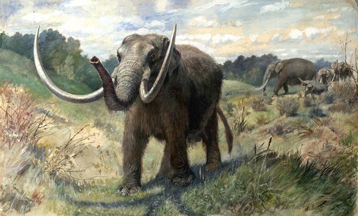
Reconstruction of an American mastodon herd by American painter of large extinct fauna Charles R. Knight
The DNA extraction turned-up signs of 70 vascular plants, including poplar, spruce and yew now typically found at much lower latitudes, alongside sedges, shrubs and birch-tree species that still grow in Greenland. The climate was substantially warmer than it is now. The fauna included elephants – probably mastodons (Mammut) but not mammoths (Mammuthus) and caribou, as well as rabbits, geese and various species of rodents. There were even signs of ants and fleas. The overall assemblage of plants has no analogue in modern vegetation, perhaps because of the absence of anthropogenic influences, such as fires, the smaller extent of glaciations, their shorter duration and less established permafrost during the early Pleistocene. The last factor could have allowed a quicker and wider spread of coniferous-deciduous woodland, found today in NE Canada. In turn this spread of vegetation would have drawn in herds of large herbivores, later mastodons being known to have been wide-ranging forest dwellers. Willerslev suggests that the study has a potential bearing on how ecosystems may respond to climate change.
This brief note takes up a thread begun in Can a supernova affect the Earth System? (August 2020). In February 2020 the brightness of Betelgeuse – the prominent red star at the top-left of the constellation Orion – dropped in a dramatic fashion. This led to media speculation that it was about to ‘go supernova’, but with the rise of COVID-19 beginning then, that seemed the least of our worries. In fact, astronomers already knew that the red star had dimmed many times before, on a roughly 6.4-year time scale. Betelgeuse is a variable star and by March 2020 it brightened once again: shock-horror over; back to the latter-day plague.
When stars more than ten-times the mass of the Sun run out of fuel for the nuclear fusion energy that keeps them ‘inflated’ they collapse. The vast amount of gravitational potential energy released by the collapse triggers a supernova and is sufficient to form all manner of exotic heavy isotopes by nucleosynthesis. Such an event radiates highly energetic and damaging gamma radiation, and flings off dust charged with a soup of exotic isotopes at very high speeds. The energy released could sum to the entire amount of light that our Sun has shone since it formed 4.6 billion years ago. If close enough, the dual ‘blast’ could have severe effects on Earth, and has been suggested to have caused the mass extinction at the end of the Ordovician Period.
Betelgeuse is about 700 light years away, massive enough to become a future supernova and its rapid consumption of nuclear fuel – it is only about 10 million years old – suggests it will do so within the next hundred thousand years. Nobody knows how close such an event needs to be to wreak havoc on the Earth system, so it is as well to check if there is evidence for such linked perturbations in the geological record. The isotope 60Fe occurs in manganese-rich crusts and nodules on the floor of the Pacific Ocean and also in some rocks from the Moon. It is radioactive with a half-life of about 2.6 million years, so it soon decays away and cannot have been a part of Earth’s original geochemistry or that of the Moon. Its presence may suggest accretion of debris from supernovas in the geologically recent past: possibly 20 in the last 10 Ma but with apparently no obvious extinctions. Yet that isotope of iron may also be produced by less-spectacular stellar processes, so may not be a useful guide.
There is, however, another short-lived radioactive isotope, of manganese (53Mn), which can only form under supernova conditions. It has been found in ocean-floor manganese-rich crusts by a German-Argentinian team of physicists (Korschinek, G. et al. 2020. Supernova-produced 53Mn on Earth. Physical Review Letters, v. 125, article 031101; DOI: 10.1103/PhysRevLett.125.031101). They dated the crusts using another short-lived cosmogenic isotope produced when cosmic rays transform the atomic nuclei of oxygen and nitrogen to 10Be that ended up in the manganese-rich crusts along with any supernova-produced 53Mn and 60Fe. These were detected in parts of four crusts widely separated on the Pacific Ocean floor. The relative proportions of the two isotopes matched that predicted for nucleosynthesis in supernovas, so the team considers their joint presence to be a ‘smoking gun’ for such an event.
The 10Be in the supernova-affected parts of the crusts yielded an age of 2.58 ± 0.43 million years, which marks the start of the Pleistocene Epoch, the onset of glacial cycles in the Northern Hemisphere and the time of the earliest known members of the genus Homo. A remarkable coincidence? Possibly. Yet cosmic rays, many of which come from supernova relics, have been cited as a significant source of nucleation sites for cloud condensation. Clouds increase the planet’s reflectivity and thus act to to cool it. This has been a contentious issue in the debate about modern climate change, some refuting their significance on the basis of a lack of correlation between cloud-cover data and changes in the flux of cosmic rays over the last century. Yet, over the five millennia of recorded history there have been no records of supernovas with a magnitude that would suggest they were able to bathe the night sky in light akin to that of daytime. That may be the signature of one capable of affecting the Earth system. Thousands that warrant being dubbed a ‘very large new star’are recorded, but none that ‘turned night into day’. The hypothesis seems to have ‘legs’, but so too do others, such as the slow influence on oceanic circulation of the formation of the Isthmus of Panama and other parochial mechanisms of changing the transfer of energy around our planet
As the Yalung-Tsangpo River on the northern flank of the Himalaya approaches a bend the rotates its flow by almost 180 degrees to become the Brahmaputra it enters one of the world’s largest canyons. Over the 200 km length of the Tsangpo Gorge the river descends two kilometres between peaks that tower 7 km above sea level. Since the area is rising tectonically and as a result of the unloading that attends erosion, for the Tsangpo to have maintained its eastward flow it has been suggested that an average erosion rate of 3 to 5 km per million years was maintained continuously over the last 3 to 5 Ma. However, new information from the sediments downstream of the gorge suggests that much of the gorge’s depth was cut during a series of sudden episodes (Lang, K.A. et al. 2013. Erosion of the Tsangpo Gorge by megafloods, Eastern Himalaya. Geology, v. 41, p. 1003-1006).
The Yarlung Tsangpo River watershed which drains the north slope of the Himalayas. (credit: Wikipedia)
It has become clear from a series of mountainside terraces that during the Pleistocene glaciers and debris from them often blocked the narrow valleys through which the river flowed along the northern flank of the Himalaya. Each blockage would have impounded enormous lakes upstream of the Tsangpo Gorge, containing up to 800 km3 of water. Failure of the natural dams would have unleashed equally spectacular floods. The researchers from the University of Washington in Seattle examined the valley downstream of the gorge, to find unconsolidated sediments as much as 150 m above the present channel. They have similar grain size distributions to flood deposits laid down some 30 m above the channel by a flood unleashed in 2000 by the failure of a temporary dam caused by a landslide. The difference is that the higher level deposits are densely vegetated and have well-developed soils: they are almost certainly relics of far larger floods in the distant past from the lakes betrayed by the terraces above the Tsangpo Gorge.
By measuring the age of zircons found in the megaflood deposits using the U/Pb methods the team have been able to show that the sediments were derived mainly from 500 Ma crystalline basement in the Tsangpo Gorge itself rather than from the younger terranes in Tibet. There are four such deposits at separate elevations above the modern river below the gorge. Like the 2000 AD flood deposit, each terrace is capped by landslide debris suggesting that flooding and associated erosion destabilised the steep slopes so characteristic of the region. Because the valleys are so narrow (<200 m at the bottom), each flood would have been extremely deep, flows being of the order of a million cubic metres per second. The huge power would have been capable of moving blocks up to 18 m across with 1 m boulders being carried in suspension. It has been estimated that each of the floods would have been capable of removing material that would otherwise have taken up to 4000 years to erode at present rates of flow.
Around 3.6 Ma ago a large extraterrestrial projectile slammed into the far north-east of Siberia forming crater 16 km across. The depression soon filled with water to form Lake El’gygytgyn, on whose bed sediments have accumulated up to the present. A major impact close to the supposed start of Northern Hemisphere glacial conditions was a tempting target for coring: possibly two birds with one stone as the lowest sediments would probably be impact debris and boreal lake sediments of this age are as rare as hens’ teeth. The sedimentary record of Lake El’gygytgyn has proved to be a climate-change treasure trove (Brigham-Grette, J and 15 others 2013. Pliocene warmth, polar amplification, and stepped Pleistocene cooling recorded in NE Arctic Russia. Science, v. 340, p. 1421-1426).
Lake El’gygytgyn impact crater. (credit: Wikipedia)
The team of US, Russian, German and Swedish scientists discovered that the sedimentary record was complete over a depth of 318 m and so promised a high resolution climate record. The striking feature of the sediments is that they show cyclical variation between five different facies, four of which are laminated and so preserve intricate records of varying weathering and sediment delivery to the lake. The sediments also contain pollens and diatom fossils, and yield good magnetic polarity data. The last show up periods of reversed geomagnetic polarity, which provide age calibration independent of relative correlation with marine isotope records.
A host of climate-related proxies, including pollen from diverse tree and shrub genera, variations in silica due to changes in diatom populations and organic carbon content in the cyclically changing sedimentary facies are correlated with global climate records based on marine-sediment stable isotope. These records reveal intricate oscillations between cool mixed forest, cool coniferous forest, taiga and cold deciduous forest, with occasional frigid tundra conditions through the mid- to late Pliocene. Compared with modern conditions NE Siberia was much warmer and wetter at the start of the record. Around the start of the Pleistocene sudden declines to cooler and drier conditions appear, although until 2.2 Ma ago average summer conditions seem to have been higher that at present, despite evidence from marine proxies of the onset of glacial-interglacial cycles in the Northern Hemisphere.
In detail, Lake El’gygytgyn revealed some surprises including rapid onset of a lengthy cold-dry spell of tundra conditions between 3.31 to 3.28 Ma. The first signs that the lake was perennially frozen appear around 2.6 Ma, well before evidence for the first continental glaciation in North America, presaged by signs around 2.7 Ma that winters consistently became colder than present ones. Overall the lake record presents a picture of a stepped shift in climate in the run-up to the Great Ice Age. Lake El’gygytgyn seems set to become the standard against which other, more patchy records around the Arctic Ocean are matched and correlated. Indeed it is the longest and most detailed record of climate for the Earth’s land surface, compared with 120 and 800 ka for the Greenland and Antarctic ice-caps.
Modelling their findings against likely atmospheric CO2 levels the authors provide grist to the media mill which focuses on how the late Pliocene may be a model for a future warm Earth if emissions are not curtailed, with visions of dense polar forests