Former Senior Lecturer at British Open University, research in remote sensing of arid lands, groundwater exploration, Precambrian tectonics and geochemistry
A press release from the Max Planck Institute for Evolutionary Anthropology in Leipzig, Germany, announces the completion of the most precise genome from a third Neanderthal individual. For the first time it is possible to distinguish copies of the genes inherited by the individual from both parents. The data release coincided with a review of genetic evidence for interbreeding between early Homo sapiens and other species.
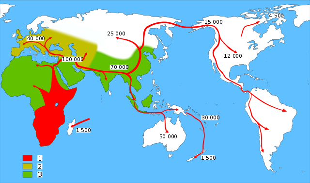
Modern human migration out of and within Africa relative to the domains of coeval archaic humans 1 = modern humans 2 = Neanderthals 3 = other archaic humans (credit: Wikipedia)
One of the key areas for unravelling the range of tectonic processes involved in the assembly of continents lies in the Western Cordillera of North America, made up of dozens of slivers of mutually exotic terranes. Their exposed upper parts remain largely intact and are dateable using fossils or radiometric dating. Through assiduous palaeomagnetic research it is sometimes possible to chart their motions over time to see the manner in which they approached and collided with one another. Geoscientists are now able to link such a complex process with underlying tectonics, not by inference but through direct seismological observation of the remains of subducted slabs in the mantle deep beneath.
The crumpled Farallon Plate beneath North America, colours showing different depths in the mantle (credit: Karin Sigloch)
This item can be read in full at Earth-logs in the Tectonics archive for 2013
Much attention has centred on fracking shales to release otherwise locked-in gas, while production of liquid petroleum by the same kind of process is also increasing with little publicity, especially in the US. From a purely economic standpoint wells that yield oil and gas from fractured shale might seem to be quite a boon. Well, they probably are, if the gas can be sold. One of the biggest shale-oil targets is the Late Devonian to Early Carboniferous Bakken Shale in the Williston Basin that stretches across 360 thousand km2‑ beneath parts of the Dakotas, Wyoming and Montana in the US and Saskatchewan in Canada. This shale is the source rock for most of the conventional oil production from the Williston basin since the 1940s. At the start of the 21st century direct production of oil from the Bakken began in North Dakota, unleashing a major drilling boom and a ten-fold increase in land-leases for production. The state is now the second largest US oil producer after Alaska warranting a major feature National Geographic. Trouble is North Dakota is not well served by pipelines of any kind and oil is shipped by rail, much as it was in the early days of the US oil industry.
Typical natural gas flare with black-carbon plume (credit: Wikipedia)
The natural gas released by fracking is simply wasted, partly by flaring at the wellhead but an unknown volume of pure methane is simply vented to the atmosphere. At rough 25 times the greenhouse warming capacity of CO2 the perverted economics of waste methane is, unsurprisingly, becoming scandalous and increasingly dangerous. Such is the magnitude of shale-gas production in the US the price of natural gas has fallen dramatically so that from the Williston Basin simply carries no profit and therefore has nowhere to go except up in flames or directly to the air. The US Environmental Protection Agency apparently can do little to halt the venting. British onshore source rocks, such as the Upper Jurassic Kimmeridge Shale, which has a hydrocarbon content up to 70% and is regarded as the most important rock in Europe being the source for much of the petroleum beneath the North Sea and other oil provinces, are likely targets for fracking now the UK government has given the go-ahead in a new ‘dash for gas’. Chances are it may become a dash for onshore shale-oil .
Manganese nodules finally tagged for production
Manganese nodules taken from the bottom of the Pacific. (credit: Wikipedia)
Almost 40 years ago my desk was almost buried under tomes of information about dull black nodules looking like blighted potatoes as I worked on the now abandoned Level-2 Open University course on The Earth’s Physical Resources. Made mainly out of manganese and iron minerals they also contain ore-grade amounts of nickel, copper and cobalt together with other metals. Were they beneath the crust they would be mined eagerly, but such manganese nodules litter vast areas at the surface of the oceans’ abyssal plains. Such was their potential that around half a billion dollars was spent on oceanographic and geochemical surveys to map the richest nodule fields. Part of the attraction at a time when the non-renewable nature of conventional metal deposits was touted as a threat to civilisation as we know it, as in The Limits to Growth, was that the nodules were zoned and clearly growing: they appear to be renewable metal resources.
Mining them is likely to be hugely costly: they will have to be dredged or sucked-up from the deep ocean basins; intricate metallurgical methods are needed to separate and smelt the paying metals and the risks of deep-sea pollution are obvious. As with shale gas, the UK Tory premier David Cameron has leapt onto Lockheed Martin UK’s announcement that it is finally profitable to get at the nodules, in the manner of the proverbial ‘rat up a drainpipe’. Cameron believes that the venture to harvest one of the most metalliferous patches on the east Pacific floor off Mexico may rake the UK’s economic potatoes out of the fire to the tune of US$60 billion over the next 30 years. Lockheed Martin is an appropriate leader in this scramble having designed some of the equipment aboard a ship financed by Howard Hughes, the 50 thousand tonne Glomar Explorer. A curious vessel, the Glomar Explorer was widely publicised in the mid-70s as the flagship for a manganese nodule pilot project. In fact it was built to snaffle a Soviet submarine (K-129) and its contents of codebooks, technical equipment and nuclear missiles that sank to the abyssal plains in the Pacific about 2500 km to the north-west of Hawaii. It did grapple the submarine, some cryptographic equipment, a couple of nuclear tipped torpedoes and six of the dead crew members. It is still operational, but as an ultra-deep water drill rig.
We will have to wait to see if nodule mining is a ‘go-er’, and very little information has emerged about methodology. The target metal is probably nickel with its importance in rechargeable batteries, plus rare-earth metals that are in notoriously short supply. Whether or not raking, dredging or sucking-up the nodules will have insupportable environmental impact depends on the amount of on-board processing; the nodules themselves are pretty much insoluble. Extracting and separating the metals will probably involve some kind of solution chemistry rather than the beneficiation common in most on-shore metal mines. Such hydrometallurgy has considerable potential for pollution, unless the raw nodules are shipped to shoreline facilities, at a hefty cost. One thing occurred to me while writing about manganese nodules as a major resource was that their blends of metals would not match the proportions actually required in commerce. On a grand scale their exploitation could well play havoc with currently booming metal prices and drive on-shore mining to the wall. But, to be frank, I think this is a bit of tropical sea-bed bubble fraught with legal tangles connected with the United Nations Convention on the Law of the Sea.
At first reading this item’s title might seem to convey nonsense, yet there is an interesting relationship between these two very different disciplines. It concerns the pillaging of South and Central America by conquistadors who followed Columbus’s pioneering route across the North Atlantic in 1492. Aside from glory their motive was profit, and that was most conveniently concentrated in the form of gold and silver, to be found in abundance among the native people of what came to be known as the Americas. Once such plunder declined silver ores were soon discovered in Peru and Mexico, thereby maintaining the supply. Bullion or plate – so named from the fact that precious metal was most often transported in the form of sheets – was the major cargo of the great treasure ships in the period from 1515 to 1650. It is remembered in such geographic names as the Rio de la Plata separating modern Argentina and Uruguay.
Klaus Kinski, well into his role as an insane conquistador, disputes the script with director Werner Herzog while shooting “Aguirre, The Wrath Of God” (credit: Flickr p373)
It might seem that when such a vast amount of loot entered Europe the buying power of silver in particular would have fallen to result in inflation in the price of basic commodities, much as printing paper money may have that result nowadays. Indeed, over those roughly 150 years prices increased by as much as five times. Another factor was a tendency for silver supply to be augmented simply by debasing newly minted currency with other metals. Yet another is that over the same period China adopted silver as a money commodity increasing demand and so spurring exploration and advances in metallurgical extraction from new ores. Furthermore, the entire fabric of economy in Europe began to shift as feudalism began to be supplanted by capitalism at the close of Medieval times. The sheer complexity of competing factors has made the so-called ‘Price Revolution’ of the 16th and 17th centuries a thorny issue for economic historians. This is where geochemists found that they had a ‘shout’ in what Thomas Carlisle dubbed the ‘dismal science’.
Silver ores also contain lead and copper, which inevitably contaminate silver metal extracted from them. Depending on the processes involved in mineralisation the abundances of both metals vary from mine to mine. More tellingly, so do the relative proportions of the different Pb and Cu isotopes, Pb isotopes reflecting the age of the rocks in which ores are found. Inherited by coinage, the isotopes can be used to assess provenance of coins (Desaulty, A.-M. & Albarede, F. 2013. Copper, lead and silver isotopes solve a major economic conundrum of Tudor and early Stuart Europe. Geology, v. 41, p. 135-138), while the dates embossed on coins at the mint potential chart the course of the bullion trade. Desaulty and Albarede show that silver from the vast Potosí mine in modern Bolivia opened by conquistadors barely shows up in British coinage of the period, which is dominated with Mexican isotopic signatures as well as those from European mines. The latter account almost exclusively for the coinage of the late Medieval period. The conclusion is that the huge potential of Potosí served the needs of Spanish entrepreneurs though a trans-Pacific Spanish trade in which Bolivian silver bought goods from China, including gold. Spanish coins, on the other hand, show little of either Bolivian or Mexican silver, suggesting that Spanish world trade may well have used American bullion directly to purchase goods throughout its sphere of influence centred on the Philippines, while Mexican silver engaged in European trade and also found its way into the British economy by way of the slave trade.
Although Desaulty and Albarede claim to have solved a ‘conundrum’ it seems more likely that their revelations will make historians of post-Medieval economics scratch their heads even more.
Geologists realized long ago that volcanic activity can have a profound effect on local and global climate. For instance, individual large explosive eruptions can punch large amounts of ash and sulfate aerosols into the stratosphere where they act to reflect solar radiation back to space, thereby cooling the planet. The 1991 eruption of Mt Pinatubo in the Philippines ejected 17 million tones of SO2; so much that the amount of sunlight reaching the Northern Hemisphere fell by around 10% and mean global temperature fell by almost 0.5 °C over the next 2 years. On the other hand, increased volcanic emissions of CO2 over geologically long periods of time are thought to explain some episodes of greenhouse conditions in the geological past.
Ash plume of Mount Pinatubo during its 1991 eruption. (credit: Wikipedia)
The converse effect of climate change on volcanism has, however, only been hinted at. One means of investigating a possible link is through the records of volcanic ash in sea-floor sediment cores in relation to cyclical climate change during the last million years. Data relating to the varying frequency volcanic activity in the circum Pacific ‘Ring of Fire’ has been analysed by German and US geoscientists (Kutterolf, S. et al. 2013. A detection of Milankovich frequencies in global volcanic activity. Geology, v. 41, p. 227-230) to reveal a link with the 41 ka periodicity of astronomical climate forcing due to changes in the tilt of the Earth’s axis of rotation. This matches well with the frequency spectrum displayed by changes in oxygen isotopes from marine cores that record the waxing and waning of continental ice sheets and consequent falls and rises in sea level. Yet there is no sign of links to the orbital eccentricity (~400 and ~100 ka) and axial precession (~22 ka) components of Milankovitch climatic forcing. An interesting detail is that the peak of volcanism lags that of tilt-modulated insolation by about 4 ka.
At first sight an odd coincidence, but both glaciation and changing sea levels involve shifting the way in which the lithosphere is loaded from above. With magnitudes of the orders of kilometres and hundreds of metres respectively glacial and eustatic changes would certainly affect the gravitational field. In turn, changes in the field and the load would result in stress changes below the surface that conceivably might encourage subvolcanic chambers to expel or accumulate magma. Kutterolf and colleagues model the stress from combined glacial and marine loading and unloading for a variety of volcanic provinces in the ‘Ring of Fire’ and are able to show nicely how the frequency of actual eruptions fits changing rates of deep-crustal stress from their model. Eruptions bunch together when stress changes rapidly, as in the onset of the last glacial maximum and deglaciations, and also during stadial-interstadial phases.
Whether or not there may be a link between climate change and plate tectonics, and therefore seismicity, is probably unlikely to be resolved simply because records do not exist for earthquakes before the historic period. As far as I can tell, establishing a link is possible only for volcanism close to coast lines, i.e. in island arcs and continental margins, and related to subduction processes, because the relative changes in stress during rapid marine transgressions and recessions would be large.. Deep within continents there may have been effects on volcanism related to local and regional ice-sheet loading. In the ocean basins, however, there remains a possibility of influences on the activity of ocean-island volcanoes, though whether or not that can be detected is unclear. Some, like Kilauea in Hawaii and La Palma in the Canary Islands, are prone to flank collapse and consequent tsunamis that could be influenced by much the same process. Another candidate for a climate-linked, potentially catastrophic process is that of destabilisation of marine sediments on the continental edge, as in the Storegga Slide off Norway whose last collapse and associated tsunami around 8 thousand years ago took place during the last major rise in sea level during deglaciation. The climatic stability of the Holocene probably damps down any rise in geo-risk with a link to rapid climate change, which anthropogenic changes are likely to be on a scale dwarfed by those during ice ages.
Liang Bua cave on Flores, Indonesia where fossils of Homo floresiensis were discovered in 2003 (credit: Wikipedia)
When they were first discovered in Liang Bua cave on the Indonesian island of Flores diminutive hominin remains sparked off a heated debate. Part of the reason for dispute was the age of the deposit in which they were found (18 to 850 ka), so young that it indicated possible cohabitation on the island with anatomically modern humans. On the one hand, the finders claimed that they represented a previously unknown hominin species. Other specialists considered that the tiny size (adults no taller than about a metre with brain capacity around that of australopithecines) indicated some congenital dwarfism.
Homo floresiensis skull (credit: Wikipedia)
In the 9 years since the remains came to light, several anatomically features have been cited to support the view of a distinct hominin species: their lack of a chin and different arm and shoulder anatomy, which H. floresiensis shares with H. erectus and H. georgicus. The fossils are associated with simple stone tools and bones of a variety of prey animals that show cut marks and charring, suggesting that cooking was part of these hominins’ lifestyle; despite having small brains they were not unintelligent.
Substantial remains of nine or more individuals have been unearthed so that anatomical detail is almost complete. In 2007 details were published of three well-preserved wrist bones from the original find. They too were sufficiently different from modern and Neanderthal humans to warrant confirmation that H. floresiensis is indeed a distinct hominin species. Further work on wrist bones from other individuals has now more or less put the seal on this identity (Orr, C.M. et al. 2013. New wrist bones of Homo floresiensis from Liang Bua (Flores, Indonesia). Journal of Human Evolution, v. 64, p. 109-129), the authors concluding that ‘The pattern of morphology … supports H. floresiensis as a valid taxon and refutes the hypothesis that these specimens represent modern humans with some kind of pathology or growth disturbance’. They take matters further by suggesting that their lineage was established before divergence of modern humans and Neanderthals. As with the shoulder morphology that of their wrists would have somewhat hindered tool-making dexterity, but nonetheless they did make tools.
The single most vital resource for human survival is clean, fresh drinking water. For a large proportion of the world’s population that right is not guaranteed, with harrowing consequences especially for children under 5-years old. Without careful processing surface water can only rarely be assumed fit to drink, especially in areas with dense populations of people, livestock or wildlife. Groundwater, on the other hand, has generally passed through aerated upper soil layers before it ended up below the water table in an aquifer. In that passage it is filtered and subject to various oxidising processes, both chemical and organic, that renders it a great deal more free of pathogens than standing or running surface water. Remarkably, a common mineral in any oxidised soil horizon is goethite, an iron hydroxide, which is capable of adsorbing a variety of potentially damaging ions. So, of all fresh water that stored beneath the surface is the safest for people to drink.
By its very nature groundwater is hidden and requires both geological exploration and the drilling or digging of wells before it can become a resource. Areas underlain by simple stratiform sediments or lava flows present far less of a challenge than do geological settings with complex structures or that are dominated by ancient crystalline basement rocks. Time and again, however, crises in water supply arise from drought or sudden displacements of populations a great deal faster than the pace of groundwater exploration or development needed to cope with shortages. Were the potential for subsurface supplies known beforehand relief would be both quicker and more effective than it is at present.
Image of simulated depth to water table for Africa (Courtesy of Y. Fan, Rutgers University, USA)
Thanks to three geoscientists from Rutgers University, USA and the University of Santiago de Compostela, Spain, (Fan, Y et al. 2013. Global patterns of groundwater table depth. Science, v. 339, p. 940-943) a start has been made in quantifying the availability of groundwater worldwide. They have modelled how the likely depth of the water table may vary beneath the inhabited continents. As a first input they digitised over 1.5 million published records of water table depths. Of course, that left huge gaps, even in economically highly developed areas. There is also bias in hydrogeological data towards shallow depths as most human settlements are above easily accessible groundwater.
To fill in the gaps and assess the deeper reaches of groundwater Fan et al. adapted an existing model that assumes groundwater depth to be forced by climate, topography and ultimately by sea-level. It is based on algorithms that predict groundwater flow after its infiltration from the surface. Such an approach leaves out drawdown by human interference and is at a spatial resolution that removes local complexities. The influence of terrain relies on the near-global elevation data acquired by NASA’s Shuttle Radar Topography Mission (SRTM) in February 2000, resampled to approximately 1 km spatial resolution, supplemented by the less accurate Japan/US ASTER GDEM produced photogrammetrically from stereo- image pairs. Other input data are assumptions about variation in hydraulic conductivity, which is reduced to a steady decrease with depth, models of infiltration from the surface based on global rainfall and evapotranspiration patterns and those of surface drainage and slopes. No attempt was made to input geological information
The results have been adjusted using actual water-table depths as a means of calibration across climate zones on all inhabited continents. The article itself is not accessible without a Science subscription, but the supplementary materials that detail how the work was done are available to the public, and include remarkably detailed maps of simulated water table depths for all continents except Antarctica. The detail is much influenced by terrain to create textures that override climate, which might suggests that the results flatter to deceive. Yet the modelling does result in valleys and broad basins of unconsolidated sediment showing shallower depths that tallies with the tendency for less infiltration where slopes are steep and run-off faster. The fact that the degree of fit between model and known hydrogeology is high does suggest that at the regional scale the maps are very useful points of departure for more detailed work that brings in lithological and structural information.
Sample from a banded iron formation (BIF) from the Barberton Greenstone Belt, South Africa. (credit:K. Lehmann and J.D. Kramers via Wikipedia)
More than a decade ago the oldest sedimentary rocks in the world at Isua in West Greenland hit the headlines, and not for the first time. Inclusions of graphite in crystals of the mineral apatite from the Isua supracrustals had yielded carbon isotopes unusually deficient in 13C relative to 12C, which is often regarded as a sign that life was involved in the carbon cycle at the time. The Isua rocks have been reliably dated at around 3.8 billion years (Ga) so that added over 400 Ma to the time at which life was present on Earth. Sedimentary rocks formed at 3.4 Ga contain the first tangible signs in the form of stromatolites thought to have been secreted by biofilms of blue-green bacteria which are oxygen-generating photosynthesisers. Sadly, limestones at Isua, indeed all the putative sedimentary rocks there were metamorphosed and deformed plastically so that such features, if they were ever present, had been obliterated. Apatite was thought to be so strong and resistant to heating that carbon within its crystals would have preserved original isotopic ‘signatures’. Detailed studies to test this hypothesis refuted the early age for life, which reverted back to around 3.4 Ga. But Isua presents too good an opportunity for its geochemical secrets to be left uninvestigated.
The latest targets are its iron isotopes. Isua includes metamorphosed banded ironstones composed largely of magnetite and quartz. Magnetite is iron oxide (Fe3O4) and begs the question of how such an oxygen-rich mineral formed in such volumes in sediment if photosynthesizing life had not made elemental oxygen available. That would oxidize soluble ferrous ions (Fe2+) to the insoluble ferric form (Fe3+) in order for iron oxide to precipitate from sea water in large amounts. There is no other means known for oxygen to be produced in a planet’s surface environment. A team at the University of Wisconsin’s NASA Astrobiology Institute, led by Andrew Czaja and joined by Stephen Moorbath of the University of Oxford, who set the entire West Greenland story rolling by leading its geochronological investigation since the early 1970s, have made a breakthrough (Czaja, A.D. et al. 2013. Biological Fe oxidation controlled deposition of banded iron formation in the ca. 3770 Ma Isua Supracrustal Belt (West Greenland). Earth and Planetary Science Letters, v. 363, p. 192-203).
Any element that has more than one naturally occurring isotope offers the possibility of studying various kinds of chemical process by looking for changes to the relative proportions of the different isotopes. Having different relative atomic masses isotopes of an element have slightly different chemical properties so that one is likely to be more favoured in a reaction than another. In the case of iron, the most important reactions in surface processes are those that depend on reducing and oxidising conditions, i.e. producing soluble Fe2+ and insoluble Fe3+ respectively. Oxidation and precipitation of iron oxides and hydroxides tend to favour the heavier isotope 56Fe over the more common 54Fe resulting in an increase in the 56Fe/54Fe ratio (δ56Fe). This is found throughout the Isua ironstones, but may again reflect metamorphism. However, such was the detail of this study that δ56Fe values were measured for many individual bands. Instead of showing roughly the same values throughout the rock, each band had a different value. That strongly suggests that values produced during sedimentation had been preserved. It seems that a bacterial mechanism of oxidation was involved. Moreover, by comparing the 3.8 Ga Isua ironstones with examples dated at 2.5 Ga from Australia the team found different isotopic values that implicates different kinds of bacteria involved in producing apparently similar rock types. The twist is that the most likely bacterial type involved at Isua may have been a photosynthesiser, but not of the kind that releases elemental oxygen instead transferring it from water to combine directly with the ions of iron that its photosynthesis had oxidised. The younger ironstones seem more likely to have involved cyanobacteria that do excrete oxygen; shortly after their formation the Earth’s surface increasingly became oxygen-bearing.
Throughout the Precambrian, BIFs appear and then vanish from the record only to reappear when geologist least expect them, for instance around the time of the Snowball Earth events in the Neoproterozoic Era. Iron isotopes could well become handy tools to probe the processes that formed them.
Artist’s impression of the Chicxulub impact – (credit: Wikipedia)
Since 1980, when Alvarez père et fils discovered signs of a globe-affecting impact event in rocks marking the stratigraphic boundary at the end of the Mesozoic Era –between the Cretaceous and Palaeogene Periods – there has been continual bickering over the cause of the mass extinction at that time. Unlike other mass extinctions that one marked the end of an Era dominated in the popular mind by the iconic dinosaurs. Besides that focus, many geologists have been averse to external, ‘wham-bam-thank-you-ma’am’ explanations for shifts in the fossil record: a sort of Lyellian view that geological change had to be at the pace of the humble tortoise and must be due to something in the Earth system itself. Then a majority, this conservative faction looked instead to the effects of the voluminous basalt flood that had affected western India at around the same time. Incidentally, that apparent match to the end-Mesozoic extinction sparked an interest in volcanic associations with other mass extinctions.
Discovery by geophysicists of evidence for a large almost completely buried impact basin, about 180 km across, centred in the Caribbean off Mexico’s Yucatan Peninsula swayed opinion towards an extraterrestrial cause when it became clear that the impact had occurred around the time of the K-Pg boundary, then placed at 65 Ma. Soon there were claims that the Deccan Traps had erupted in less than a million years at that time, together with doubts cast on the actual age of the Chicxulub crater. The time-spread of the Deccan volcanism enlarged with more dating to between 68 and 60 Ma; and so the to-ing and fro-ing continued, gleaning sizeable grants for entrepreneurial geoscientists keen on one or other of what were becoming bandwagon topics. Then the ‘golden spike’ marking the time of the mass extinction became the subject of controversy. A means of precise dating is to examine signs in sediments of cyclical climate change using the Milankovich approach, although before 50 Ma only the 405 ka cyclicity predicted from astronomy is readily detected. Using well-dated volcanic horizons to calibrate such a stratigraphic dating method might be the key, but it became apparent that 65.3, 65.7 or 66.1 Ma all seemed to have the same likelihood.
The two kill mechanisms that had been proposed are in fact very different, not merely in terms of what might have happened to atmospheric chemistry, climate, photosynthesis and so on, but concerning their timing. Repeated episodes of major basalt eruption every 100 ka or so would have had a chronic and perhaps cumulative effect on the Earth’s biota; i.e. even a 10 Ma spread for Deccan basalt floods bracketing the actual die-off would be acceptable as a cause. An impact however takes no more than a second to occur, because of the hypersonic speed induced by Earth’s gravity as well as that of the asteroid through the Solar System. All its immediate effects – entry flash; crater excavation; debris fall-out; atmospheric dust and toxic gas accumulation; climate change; acid rain and tsunamis – would have been done and dusted over a matter of a few thousand years. The Chicxulub impact would have been a catastrophe that was instantaneous in geological terms. Its occurrence would need to bear the same date as the mass extinction itself to be seen as incontrovertible; well, at least to the majority of geoscientists. That point seems to have been reached.
As well as the crater, Chicxulub scattered molten rock far and wide to appear in the ‘boundary layer’ as glass spherules, which are dateable using radiometric means. So too is the timing of the mass extinction itself, provided suitable materials can be found above and below the strata across which fossil abundances change so dramatically. Paul Renne of the University of California, Riverside, and colleagues from the US, the Netherlands and Britain dated impact glasses from Haiti and volcanic ash from the late Cretaceous to early Palaeogene terrestrial sediments of Montana, USA that bracket the extinction event using multiple argon-isotope studies and the 40Ar-39Ar method (Renne, p.r. and 8 others 2013. Time scales of critical events around the Cretaceous-Paleogene boundary. Science, v. 339, p.684-687. The glasses come out at 66.038+0.049 Ma, while the Ar-Ar age of volcanic ash just above the carbon-isotope anomaly that marks the world-wide disappearance of a large proportion of living biomass is 66.019+0.021 Ma. As they say, the ages are ‘within error’ and the error is very small indeed.
So, does this work mark the end of the K-Pg controversy? Probably not, as very large sums of grant money are still tied up with on-going studies. Perhaps to assuage the fears of all those still financially addicted to answering ‘what killed the dinosaurs?’, The abstract of the paper reads thus’ ‘The Chicxulub impact likely triggered a state shift of ecosystems already under near-critical stress’.
Artist’s impression of the common ancestor of placental mammals (Credit: Science magazine)
Interestingly, in the very same issue of Science came a research article that reexamines taxonomy of 86 key living and fossil placental mammals in the light of genetic sequencing, to locate startigraphically their earliest common ancestor (O’Leary, M.A. and 22 others 2013. The placental mammal ancestor and the post-K-Pg radiation of placentals. Science, v. 339, p. 662-667). That seems to wrap up, for now, another controversy; did diminutive placental mammals arise unnoticed beneath the gaze of mighty dinosaurs, or what? It seems that some precursor mammals were able to diversify and produce a line whose fetuses grow and are nourished in the mothers uterus attached to a placenta, before live birth at an advanced stage of development, once opportunities for diversification emerged after the K-Pg event. Morphologically, the ancestor of everything from a naked mole rat to a blue whale and, of course, ourselves, seems to have been a sneaky-looking little beast with a long nose and pointy teeth. It does look like it, or its predecessor, could have scuttled unscathed amongst the leaf litter as dinosaurs engaged in their death prance…
Glacial erratic at Norber Brown that sits nicely on a limestone plinth, dues to the erratic’s having protected the limestone underneath from erosion. (credit: Wikipedia)
Few expect Earth scientists to get all sentimental, but they do. My soft spot is for one of the most rewarding and least strenuous geological sites in Britain, Norber Brow near Austwick on the southern edge of the Yorkshire Dales National Park. As well as the famous glacial erratics of Silurian greywackes perched on Lower Carboniferous limestone, 250 m to the SE by a well-trodden path is the inverse, the Variscan unconformity at the base of the Carboniferous on the very same Silurian formation. I was lucky to be taken there at age 15 by Roy Happs who taught A-level Geology, and it decided my future, there and then.
The erratics don’t just site on the limestone, but are on pedestals up to 30 cm above the surrounding limestone surface as if carefully balanced by Beowulf’s assailant Grendel. Somehow, since the time glacial flow had deposited the Silurian boulders the underlying limestone had been dissolved away; but how fast was that? That is the key to the pace at which limestone pavement, to most general visitors such a stunning and unexpected feature of the Dales, might have formed. And such a delight to hear of its terminology: clints, redolent of the former Viking people of the Dales, that stand proud between deep fissures known as grikes, a suitably ominous term of unknown derivation. Such superbly fractal landforms are, of course, but one part of karst (from the eponymous region of limestone country in Slovenia).
A classic limestone pavement in the Yorkshire Dales National Park (credit: Wikipedia)
It is really satisfying to discover that a lot of cutting-edge science has recently been aimed at Norber from a substantial review in Earth Pages’ sister journal Geology Today (Wilson, P. et al. 2013. Dating in the Craven Dales. Geology Today, v. 29 (January-February Issue), p. 16-22). The length of time that the Norber erratics have been exposed to cosmic-ray bombardment has been determined from 10Be, 26Al and 36Cl analyses with a precision of ±1000 years to 17.9 ka, shortly after the last glacial maximum (LGM) when warming and glacial melting had just begun in this part of Yorkshire. That might seem to indicate an average of 330 mm of limestone had been dissolved over that period to form the pedestals, i.e. a dissolution rate averaging about 20 micrometres per year, which is extremely rapid, geologically speaking. In 1962 when I was show the site we were told that elsewhere the limestone pavement had formed since the first field systems (Iron Age) were laid out as now useless drystone walls crossed it. Roy Happs somewhat darkly suggested that they had formed since the start of the Industrial Revolution because of acid rain.
He was pretty much wrong on that score, but cosmogenic dating of the clints shows significant discrepancies between the age of deposition of the erratics and and the exposure age of the clints. This suggests both chemical dissolution and also periods of frost shattering and gravel removal, perhaps by soil creep. Dating of other materials enlivens the history of local landform development. Another karstic feature is the presence of sinkholes or dolines that are often filled with yellowish silts that show clear textural evidence of being windblown sediments or loess. These aeolian sediments have long been regarded as post-LGM too, but optically stimulated luminescence dating of their quartz grains gives an age split between pre- (27.5 ± 2.6 ka) and post-LGM (16.5 ± 1.7 ka). Some loess elsewhere in Craven district comes out to be as young as 8.2 ka, to tally with evidence from Greenlandic ice cores for a sudden deterioration in North Atlantic seaboard climate during this early time in the Holocene.
Then there are the local caves, renowned in Victorian times for their cave bears and other mammal fossils. One bear skull from Victoria Cave in the Craven area gave a 14C age of 14.6 ± 0.4 ka which statistically coincides with that from a cut-marked horse vertebra. More than likely the bears were turfed out when humans reached Craven, but did they return when humans fled in the face of the Younger Dryas return to frigid-desert conditions? Probably not, as the YD would almost have sterilized what are now the Yorkshire Dales. Even earlier ages of 114 ka from U-Th dating of calcite flowstone that embeds hippo, elephant, rhino and hyena bones in Victoria Cave date to the previous Eemian interglacial. Indeed this speleothem has yielded ages as far back as the limit of the U-Th method (%00 ka). On a solo expedition in 1964 I had the chance to sleep-over in Victoria Cave, but pressed on with goose bumps to the nearby Youth Hostel.


 (Map Ta Phut, Rayong, Thai...")


")


