Basin and Range: From mountains to basin

The "marching caterpillars" of the Basin and Range province, showing the San Andreas Fault in  (credit: University of Maryland, USA)
The “marching caterpillars” of the Basin and Range province, showing the San Andreas Fault in green (credit: University of Maryland, USA)

The Basin and Range province of the western US is one of the world’s largest products of continental extension. Being semi-arid, sedimentation has been unable to keep pace with crustal thinning thereby giving form to its name: linear mountain ridges separated by sediment-filled basins. Despite the extreme extension the Basin and Range has an average elevation of about 1400 m, although it is well below that of the Sierra Nevada range (2000+ m) that flanks it to the west. Throughout the Mesozoic, subduction towards the east beneath the North American plate produced voluminous magmas and fold-thrust belts adding to the continental crust in a manner similar to that still occurring in the South American Andes. Extension began in earnest during the Eocene (~45 Ma) and continues today. Much of the theory regarding continental extension – listric normal faults and detachments, fault-tilt blocks, core complexes etc. – stems from studies in this huge terrain. As regards the evolution of the Basin and Range, it has been widely thought that by the Late Oligocene (~25 Ma) the thickened Cordilleran crust had been reduced to a plateau no higher than the present Sierra Nevada, which subsequent extension reduced to the present Basin and Range.

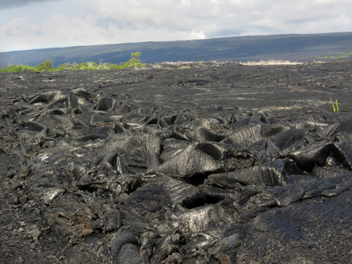
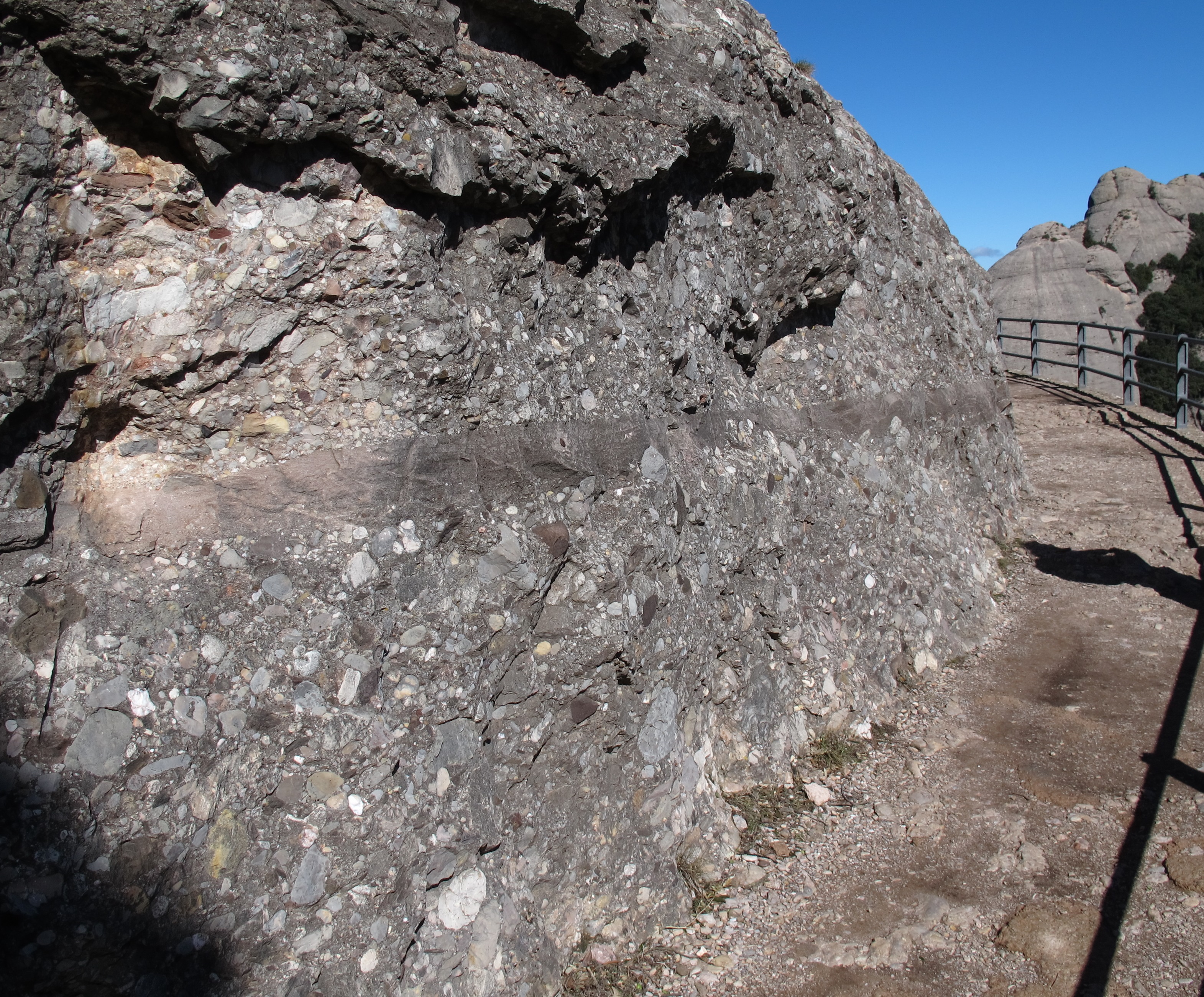
The Eocene to Miocene extensional history was punctuated by huge episodes of explosive volcanism from which hot ash flowed laterally for hundreds of kilometres, relics of which are still widespread. Such ignimbrites are often very porous and were aquifers while still exposed, until buried by sediment and subsequent nuée ardent flows. Groundwater at the time of first exposure altered the volcanic glass shards from which ignimbrites are formed, so that the oxygen and hydrogen making up what was originally rainwater is now locked in the altered ash flows. The hydrogen isotopic composition of such meteoric water is known to vary with the altitude of the clouds shedding it. Water containing the heavier hydrogen isotope deuterium (D) is preferentially precipitated at low altitudes, so that high altitude rainfall is significantly depleted in it. Because of this the alteration can give clues to the former topographic elevation of the ignimbrites when they first rushed across the land surface. Applying this method to the repeated ignimbrite events in what is now the Basin and Range has given a good idea of the actual evolution of the land surface in the western US during the Palaeogene (Cassel, E.J. et al. 2014. Profile of a paleo-orogen: high topography across the present-day Basin and Range from 40-23 Ma. Geology, v. 42, p. 1007-1010).

The results present a major surprise. In the Eocene, elevation across the area was, as anticipated, a little more than the present Sierra Nevada (2000-2500 m). This fell back to roughly 2000 m, again as theory would suggest. But by the Late Oligocene (23-27 Ma) elevation expected to have declined further over the Basin and Range actually leapt to between 2500-3500 m, up to 2.1 km higher than it is today: the opposite of prediction. Effectively, despite evidence for Palaeogene extension the crust was buoyed-up probably by an upwelling of the asthenosphere and increased heat flow. The unexpected uplift occurred towards the end of subduction of oceanic lithosphere beneath western North America, the dynamics of which prevented the westward collapse of an earlier orogen. When subduction ended and the plate-margin tectonics became strike slip, as witnessed by the San Andreas Fault, the continental crust slid apart in the manner of books on a library shelf if a bookend is removed.

Johnson, S.K. 2015. From rain to ranges. Scientific American, v. 312 (January 2015), p. 12-13.

Art from half a million years ago

original fossils of Pithecanthropus erectus (n...
Original fossils of Pithecanthropus erectus (now Homo erectus) found By Eugene Dubois in Java in 1891 (credit: Wikipedia)

Eugene Dubois, an anatomist at the University of Amsterdam in the late 19th century, became enthralled by an idea that humans had evolved in what is now Indonesia, contrary to Charles Darwin’s suggestion of an African origin. So much so that Dubois took the extraordinary step of joining the Dutch army and scrounging a posting to the Dutch East Indies to facilitate his search for a ‘missing link’, accompanied by his wife and newborn daughter. After a four-year quest, in 1891 he discovered the upper cranium and brow of a being that was obviously related to us, but also quite distinct as regards its beetling brow ridges. Pithecanthropus erectus (now Homo erectus) raised a storm of controversy, sadly only resolved in Dubois’s favour after his death in 1940. Yet, as well as mounting the first deliberate search for human ancestors, Dubois collected everything possible in the sediments at Trinil, Java, so in a sense he was also an early palaeoecologist. The collection gathered dust in Leiden for the best part of a century, until archaeologist Josephine Joordens of the University of Leiden took on the task of reviewing its contents in 2007 (Joordens, J.C.A. and 20 others 2014. Homo erectus at Trinil on Java used shells for tool production and engraving. Nature (on-line): doi:10.1038/nature13962).

Progressively enlarged views of freshwater clam from Eugene Dubois's collecti9on from Trimil, showing clear evidence of deliberate engraving. (credit: Joordens et al., 2014 in Nature; photos by Wim Lustenhouwer, VU University Amsterdam
Progressively enlarged views of freshwater clam from Eugene Dubois’s collection from Trinil, showing clear evidence of deliberate engraving. (credit: Joordens et al., 2014 in Nature; photos by Wim Lustenhouwer, VU University Amsterdam)

Homo erectus clearly had a taste for freshwater clams and lots of their shells figure in the Trinil collection: all are of similar large size rather than showing a wide variation according to age, suggesting a shell midden rather than a natural assemblage. A piece of serendipity revealed what may prove to be the anthropological find of the year. High-quality photos of the shells taken by a visiting mollusc specialist showed up evidence that one of them had been meticulously engraved. Its surface had a near-perfectly geometric, zig-zag pattern deeply gouged by someone with a steady hand, who probably used an associated shark’s tooth as a scribing tool. Since the molluscs in life bear a dark, chitinous veneer the etching would have been more striking when freshly made. Another of these sturdy shells also show signs of having had its edge sharpened, suggesting that they were used for tools such as scrapers or graters.

The stratigraphy at Trinil suggested that the engraved shell and tools were coeval with Homo erectus, but that needed proof. Using sediment grains trapped in the shells and a combination of 40Ar/39Ar and thermoluminescence dating, the team have shown that they and the human fossils from Trinil date to between 430 and 540 thousand years ago: at least 350 ka older than the very similar engravings made by an anatomically modern human on ochre that was found at Blombos Cave in South Africa. The next-oldest putative artwork is the controversial ‘Venus’ found at Berekhat Ram on the Israel-Syria border, dated between 250 and 280 ka.

Engraved ochre from Blombos Cave, South Africa. (credit Chris Henshilwood)
Engraved ochre from Blombos Cave, South Africa. (credit: Chris Henshilwood)

Probably the majority of palaeoanthropologists have dismissed humans other than ­H. sapiens as being cognitively incapable of either abstract or figurative art. The general view is that the mental capacity to create art or design began with the creation of the Blombos engraving, was restricted to anatomically modern humans and only exploded in Europe after they had migrated there by about 40 ka. A few argue that portable art, such as the Trinil and Blombos engravings, is bound by its very nature to be rare and easily overlooked. Whether having some use – counting? – merely being the making of an idle ‘doodle’ or expressing some unknowable ritual significance, the Trinil etching is a result of creativity and controlled skill that could only be the product of the H. erectus mind. Moreover, the very close comparison with the 0.35 Ma younger Blombos engraving suggests the product of a consciousness little different from that of our direct ancestors of 75 ka ago.

Are modern humans ‘domesticated’?

While animals, especially dogs, underwent domestication the deliberate or unconscious human choice of favoured physiological and behavioural traits produced distinct differences between the ancestral species and the ‘breeds’ with which we are now familiar. In general domestication has resulted in dogs with reduced jaws and flatter faces, lower aggression, especially in the case of males, and reduced stressfulness in the company of humans and other tame dogs compared with their wolf ancestors. It is widely accepted that cats have ‘tamed themselves’ through the adoption of lifestyles associated with the benefits of close association with human communities, which have resulted in similar adaptations to those in more deliberately domesticated dogs. It is beginning to dawn on anthropologists that human social evolution may unwittingly have affected the course of our own evolution. Tighter social bonding among growing sizes of communities as brain capacity increased and the behavioural and cognitive attributes needed for that have been summarised recently by a group associated with the Social Brain hypothesis of Robin Dunbar of Oxford University, UK (Gamble, C., Gowlett, J. & Dunbar, R.I.M. 2014. Thinking Big: How the Evolution of Social Life Shaped the Human Mind. ISBN-13: 978-0500051801;Thames and Hudson: London).

It was Charles Darwin who first speculated that ‘Man in many respects may be compared with those animals which have long been domesticated’. But to what extent does the hominin fossil record support such a view? Collaborators from Duke University and the University of Iowa, USA, have set out to analyse physiological changes over the last 200 ka that may be explained in this way (Cieri, R.L. et al. 2014. Craniofacial feminization,social tolerance and the origins of behavioural modernity. Current Anthropology, v. 55, p. 419-443. Includes discussion and responses). They used the degree of projection of brow ridges, facial shape and cranial volume from 3 groups of Homo sapiens remains: skulls older than 80 ka (13 specimens); spanning 38 to 80 ka (41) and from recent humans (1367). They found that brow ridges shrank significantly over the last 80 thousand years, faces shortened and cranial capacity decreased, especially among males. This resulted in a convergence in appearance between males and females, which the authors attributed to general lowering of testosterone and stress hormone levels through selection for greater social tolerance: akin to similar physiognomic changes in domesticated dogs which DNA analyses have shown to be been linked with modification of genes associated with aggression regulation. The finding among dogs suggests that their domestication is accomplished by slower development; i.e. young animals are naturally less fearful and have a greater tendency to taming. This delayed development from foetus to adulthood, with retention in mature individuals of juvenile characteristics, is known as neoteny, and affects all manner of adult characteristics, including coloration, snout length and the adrenal glands: as adult dogs now more resemble wolf pups, so human adults are more like young chimps than elders. At a conference where Cieri et al.’s results were presented, it was observed that hunter gatherer bands are intolerant, to the point of capital punishment, of wife stealers, murderers and seriously dishonest men, whereas such reactions fall off significantly among members of larger social groups involved in agriculture and urban life. Such modern behavioural patterns tally with brow ridge, face length and cranial capacity, perhaps linked with selection for personalities more attuned to cooperation.

English: comparison of Neanderthal and Modern ...
Comparison of Neanderthal and Modern human skulls from the Cleveland Museum of Natural History (credit: Wikipedia)

Although earlier human species, such as H. neanderthalensis, heidelbergensis and erectus had significantly different skull anatomy, each had prominent brow ridges that, on this account, may signify both greater exposure to testosterone and less social tolerance, and smaller group sizes. But, so far, analysis of the Neanderthal genome has not led to publication of any comments about testosterone or stress-hormone related genes. However, a clear strand of discussion is developing around evidence rather than mere speculation about psychological/cognitive aspects of human evolution that challenges the old-style ‘what-you-see-is-what-there-was’ (WYSWTW) archaeological dogma: a dialectic of social and biological relationships.

November Picture of the Month

If any technical terms are likely to be remembered by anyone exposed to a bit of geological education, amongst them will be two that are Hawaiian Polynesian words: pahoehoe (‘pa hoy hoy’) and aa (‘a ah’). The first slides around the palate wonderfully while the latter give a sort of worrisome feel as if a large weight is about to land on one’s toes. Aa is lava with a blocky, broken and jagged surface, whereas pahoehoe refers to lava with the appearance of a freshly set torrent of toffee. November’s Picture of the Month is of basaltic lava that looks like it is chewable.

Pahoehoe lava from the Big Island of Hawaii. (Credit: Mila Zinkova)


Place your bets for a chance of posterity on Lunar Mission One

When I learned about the unveiling of Lunar Mission One (LM1) , a few days after the global excitement about ESA’a Rosetta mission following Philae’s 12 November 2014 landing on a far-distant comet and success with its core experiments, it did cross my mind that here was a bit of a let-down in PR terms. There’s an old saying – ‘What can follow the Lord Mayor’s Show?’ – and the thrill of Philae’s landing rivalled any of the events at the 2012 London Olympics, plus the science it and Rosetta promise is likely to be about as leading-edge as it will get for quite some time. So what does LM1 offer that might achieve a similar scoop, and indeed your prospect of virtual immortality?

Unlike NASA or ESA missions, LM1 is to be a crowd-funded private enterprise by Lunar Missions Ltd, and for that the subscribers will want something in exchange. Through Kickstarter anyone can have a punt to help raise the initial £600 thousand goal by midnight on 17 December. Apparently that sum is to fund 3 years full-time work by a professional management team to raise further mission funds from commercial partners to take the project further: it will cost at least £0.5 billion. At this stage you can pledge any sum you wish, but what you get in return depends on your generosity. Highlights are: for £3 to 15 the reward is ‘Our eternal thanks and a place in space history’; >£15 gets you a certificate and a place in an online ‘wall of thanks’; >£30 escalates to your name being included in a digital ‘time capsule’ taken to the Moon and buried, plus membership of the Lunar Missions Club; >£60 entitles you to a voucher to invest in your own digital ‘memory box’ to go in the capsule – one of ‘millions and millions’ – and a vote on key decisions; for >£300 you can ‘Meet the Team’; >£600 gets you annual meetings and a chance to ballot for the landing module’s name; for higher contributions there are invitations to the launch (>£1200), sealing of the digital archive capsule and your name engraved on the lander (>£3000); and – wait for it – you get a place in the viewing gallery at Mission Control if you can stump up more than £5000.

For those contributing £60 or more, what goes in the much vaunted digital ‘Memory Box’ is on a sliding scale, from the equivalent of a text message to a strand of your hair and the DNA in it. One catch, if you are thinking of resurrection, is that it will be at the bottom of a 5 cm diameter hole at least 20 m deep. The buried digital archive will also contain a record of all living species on Earth and the entire history of humankind to date, but a continually updated copy will also be freely available online. Wikipedia seems not to be associated for some reason, but every item in this public archive will be peer-reviewed through an editorial board to whose deliberations schools, colleges and universities can contribute. The buried, multi-Terabyte, digital capsule is said to have a life of perhaps a billion years. Currently the longest lived data storage (~1500 years) is still ink on vellum, whereas the most advanced static and optical digital media are estimated to have a maximum 100 year lifetime, subject to technical obsolescence. On the plus side, privacy is guaranteed, partly by the nature of the storage. So, for £10000 Joe and Josie Soap will figure on a kind of cenotaph but who- or whatever digs up the module will learn absolutely nothing about them and but conceivably could clone them from their anonymous strands of hair.

What are the science goals for an LM1 landing scheduled for 2024 that cannot be achieved by lunar-lander and sample-return missions currently under state-funded development by China, Russia, NASA, Japan and India before LM1 reaches the ‘Go/No Go’ stage? The landing is planned for the Moon’s South Pole, on the rim of a major crater. There, LM1 will drill a hole to between 20-100 m deep, using a maximum of 1 kW of solar power – this ‘will also be a major leap forward for safer and more efficient remote drilling on Earth’: make of that claim what you will. Such a hole is said to enable sampling of pristine lunar rock in 15 cm lengths of 2.5 cm diameter core through the debris of the impact that caused the crater. The core samples are to be chemically analysed in the lander to test the hypothesis that Earth and Moon shared their origins. Future missions may pick up the cores and return them for more detailed analysis on Earth. But consider this: the oldest rocks known from the Apollo programme are approximately 4.4 billion year-old, feldspar-rich anorthosites that are thought to have formed the lunar highlands through fractional crystallisation of an early magma ocean that immediately followed Moon formation. Any unfractionated lunar material is only likely, if at all, at far greater depths than 20 m, and none was found or even suggested among the 0.4 tonnes of samples returned by the Apollo missions, which have been repeatedly analysed using advanced instruments. Indeed, near-surface debris from a crater rim is unlikely to be any more diverse lithologically than the various kinds of lunar surface from which the Apollo samples were collected, and may be contaminated by whatever caused the cratering and by the immense, long-lived heating at the impact site itself.

filedesc Lunar Ferroan Anorthosite #60025 (Pla...
Lunar Ferroan Anorthosite #60025 (Plagioclase Feldspar). Collected by Apollo 16 from the Lunar Highlands near Descartes Crater. (credit: National Museum of Natural History in Washington, D.C.)

Compared with the prospect of advancing understanding of the origins of life and the Earth’s oceans, and the early stages of Solar System evolution from data provided by Rosetta and Philae, LM1 might seem less exciting, though the buzz being hyped is that it would be a People’s Mission. Yet those who place their punt on it and the commercial concerns that ultimately earn from it are two different sets of people. The ambitious global education wing will, of course, face competition from the growth of MOOCs in the science, technology, engineering and maths area that have a considerable head start, but it does have a noble ring to it. Whatever, if you make a pledge before midnight on 17 December this year and the ‘pump-priming’ target is not met by then, you pay nothing. If £600 thousand is raised there is no going back and only 10 years to wait. But what a challenge, you may well think… LM1 definitely has the edge over Virgin Galactica, but here on Earth there are probably a great many more vital challenges than either.

A supervolcano’s plumbing system

What was the most devastating natural disaster ever to face humans? It would be tempting to suggest the Indian Ocean tsunami of 26 December 2004, but that is because most people remember it with horror. In fact the worst the Earth ever flung at us was much further back in our history and left a huge spike of sulfates in the Greenland icecap at around 73 thousand years ago. This relic of volcanic aerosols that had blasted into the stratosphere was tracked back to a 100 by 30 km caldera in Sumatra now occupied by a lake (Lake Toba) that is 500 m deep in places and almost filled by a slightly off-centre island. The eruption explosively ejected 2800 cubic kilometres of magma, of which an estimated 800 km3 fell as ash across a wide swath of the tropics westwards of Sumatra at least as far as Arabia and East Africa; the line of march taken by anatomically modern humans migrating from Africa. In India and Malaysia the Toba ash layer reaches 5-10 m thickness and probably occurs undetected as a thin layer across the entire tropics. Around 1010 tonnes of sulfuric acid belched out, some to enter and linger in the stratosphere, which is estimated to have caused an average decrease in average global temperatures of 3.0 to 3.5 °C for several years. Studies of human mtDNA hint at a genetic bottleneck around the time of Toba’s eruption and a large decrease, perhaps as much as 60%, in the global population of Homo sapiens. But humans survived or quickly filled devastated land in India, where stone tools are found both below and just above the Toba ash layer.

Landsat image of Lake Toba, the largest volcan...
Landsat image (120 km across) of Lake Toba, the largest volcanic crater lake in the world. (credit: Wikipedia)

The largest volcanic eruption in the last 26 Ma, there can be little doubt that no other natural catastrophe had as large an influence on humanity as did Toba. Of course, slower processes such as climate change and ups and downs of sea level lay behind the repeated spread of humans out of Africa and probably their evolution as a whole. The drama of the Toba event has drawn attention to the massive risk posed by supervolcanoes in general, such as that centred on Yellowstone in the NW US, which show signs of activity 640 ka after its last major explosive event. Toba certainly is not dead, for its peculiar island of Samosir has been uplifted steadily since the eruption by about 450 m, probably due to influx of magma deep beneath the surface, and experiences shallow earthquakes. What lies in the guts of supervolcanoes is literally a hot topic and a new 3-D imaging method has been applied to Toba.

English: Batak village on Samosir island, Lake...
Traditional village on Samosir island, Lake Toba. (credit: Wikipedia)

Seismic tomography that uses background or ambient seismic noise has become a powerful technique for studying the crust and lithosphere when small-amplitude short-wavelength Rayleigh and Love surface waves are monitored to pick up subsurface reflecting bodies and measure variation in wave speed with depth. The greater the density of seismometers deployed, the finer the resolution of deep crustal features and 40 such detectors are in place around Lake Toba. A team of Russian, French and German geophysicists have reported new results bearing on how magma may be accumulating beneath the vast caldera (Jaxibulatov, K. et al. 2014. A large magmatic sill complex beneath the Toba caldera. Science, v. 346, p. 617-619). Down to about 7 km the tomography has picked up a structurally homogeneous low-speed zone directly beneath Samosir Island that the authors attribute to the 73 ka explosive eruption. Beneath that several magma sills appear to dominate the sub-caldera crust, possibly responsible for the post eruption uplift within the caldera: the precursor to a layered intrusive body and each an increment towards a further huge eruption.

Interpretation of seismic tomography cross section of Toba. Greens to reds increasingly negative shear speed anomaly. Showing magma sills in lower crust and 74 ka damage zone above 7 km. (credit: Jaxibulatov et al. 2014

October 2014 picture

The 1200 m Montserrat mountains in Catalonia, NE Spain (credit: Xavier Varela)

The Montserrat mountains are part of the Pre-Coastal Range of Catalonia in Spain and rise close to the capital Barcelona to form a spectacular backdrop.

https://i0.wp.com/upload.wikimedia.org/wikipedia/commons/c/cd/Montserrat_des_de_Manresa.JPG

Their peculiar pinnacled form results from their comprising tough, well-cemented thick conglomerates, pink in colour and having formed in an early Cenozoic delta. The conglomerates are in very thick, homogeneous beds riven by vertical joints. These two features control the serrated and pinnacled topography, from which is derived the ranges’ Catalan name.

https://i0.wp.com/upload.wikimedia.org/wikipedia/commons/4/4c/Montserrat_cgl_with_sst_layer.jpg
Cenozoic conglomerates of the Monserrat mountains, Catalonia (credit: Wikipedia)

Human evolution news

Since discovery of its fossilised remains in Liang Bua cave on the Indonesian island of Flores was discovered in 2004 the diminutive Homo floresienesis, dubbed the ‘hobbit’ by the media, has remained a popular news item each time controversies surrounding it have flared. To mark the tenth anniversary  of its publication of a paper describing the remains Nature has summarised the recollections of many of those involved in trying to understand the significance of H. floresiensis (Callaway, E. 2014. Tales of the hobbit. Nature, v. 514, p. 422-426). Two main schools of thought continue in dispute, one holding that it is anatomically so different from anatomically modern humans and earlier members of the genus Homo that it constitutes a new species, despite its youngest member dating back only 18 ka, the other that it is H. sapiens, its tiny size having resulted from some kind of genetic disorder, such as microcephaly or Down’s syndrome. There have been so many attempts to expunge the idea of such an odd fossil cohabiting an island with fully modern humans yet being a different and perhaps extremely archaic species that such an outlook itself seems somewhat pathological.

English: Homo floresiensis, replica Deutsch: H...
Replica of the Homo floresiensis skull from Liang Bua cave, Flores, Indonesia (credit: Wikipedia)

The evidence presented to force H. floresiensis into a deformed human mould has never been convincing, and the best way of combating that view is to document from a ‘non-combatant ‘standpoint the many ways in which its anatomy differs from ours and how it might have arisen; a job to which Chris Stringer of the Museum of Natural History in London is amply qualified (Stringer, S. 2014. Small remains still pose big problems. Nature, v. 514, p. 427-429). He, like the original discoverers, feels this is a case of evolution of small stature due to a limited population being isolated for a long time on a relatively small island, which is just what happened to elephants that colonised Flores to become the pigmy Stegodon that H. floresiensis seemingly hunted. These tiny Flores dwellers (adults were about 1 m tall) used fire and made tools, similar ones dating as far back as ~1 Ma. Stringer mentions the possibility of first human colonisation about that time by Asian H. erectus but also the view that if it happened once there may have been several waves of immigration to Flores. The unusual ‘hobbit’ anatomy is not restricted to tiny size and a small skull and brain cavity (400 cm3), but includes odd hips, wrist bones, shoulder joint and collar bone. In fact the remains bear as much or more resemblance to australopithecines like ‘Lucy’ (3.2 Ma) than to other members of our genus, even H. erectus that has been proposed as its possible ancestor. Could they be far-travelled descendants of the 1.8 Ma old H. georgicus from Dmanisi in Georgia? More fossils clearly need to be found, and Stringer raises the possibility of the search being widened to other islands east of Java, such as Sulawesi, the Philippines and Timor. He hints that in such a tectonically active region tsunamis may have led to animals and humans saving themselves and then being current dispersed on rafts of broken vegetation, rather like some survivors of the 2004 Indian Ocean tsunami who ended up 150 miles from their homes by such a means.

Another story that is set to ‘run and run’ is that of ‘alien’ DNA in the human genome and productive relations between early out-of-Africa migrants with Neanderthals, Denisovans and perhaps yet a mysterious, earlier human species. The oldest (45 ka) anatomically modern human genome sequence so far charted is from a leg bone found by a mammoth-ivory prospector in Siberian permafrost (Fu, Q. and 27 others 2014. Genome sequence of a 45,000-year-old modern human from western Siberia. Nature, v. 514, p. 445-449). Like a great many living non-Africans this individual carried about 2 % Neanderthal DNA, but unlike living people the 45 ka genome has it in significantly longer segments. That allowed the authors to re-estimate the timing of the genetic flow from Neanderthals into the individual’s ancestors. Previous estimates from living DNA geve the possibility of that being between 37-86 ka, but this closer data suggests that it happened between 7 to 13 ka before the date of the fossil femur, i.e. narrowing it down to between 52 and 58 ka closer to the widely suggested time of African exodus around 60 ka (but see an Earth Pages item from September 2014)

More on human evolution here and here

New gravity and bathymetric maps of the oceans

By far the least costly means of surveying the ocean floor on a global scale is the use of data remotely sensed from Earth orbit. That may sound absurd: how can it be possible to peer through thousands of metres of seawater? The answer comes from a practical application of lateral thinking. As well as being influenced by lunar and solar tidal attraction, sea level also depends on the Earth’s gravity field; that is, on the distribution of mass beneath the sea surface – how deep the water is and on varying density of rocks that lie beneath the sea floor. Water having a low density, the deeper it is the lower the overall gravitational attraction, and vice versa. Consequently, seawater is attracted towards shallower areas, standing high over, say, a seamount and low over the abyssal plains and trenches. Measuring sea-surface elevation defines the true shape that Earth would take if the entire surface was covered by water – the geoid – and is both a key to variations in gravity over the oceans and to bathymetry.

Radar altimeters can measure the average height of the sea surface to within a couple of centimetres: the roughness and tidal fluctuations are ‘ironed out’ by measurements every couple of weeks as the satellite passes on a regular orbital schedule. There is absolutely no way this systematic and highly accurate approach could be achieved by ship-borne bathymetric or gravity measurements, although such surveys help check the results from radar altimetry over widely spaced transects. Even after 40 years of accurate mapping with hundreds of ship-borne echo sounders 50% of the ocean floor is more than 10 km from such a depth measurement (80% lacks depth soundings)

This approach has been used since the first radar altimeter was placed in orbit on Seasat, launched in 1978, which revolutionised bathymetry and the details of plate tectonic features on the ocean floor. Since then, improvements in measurements of sea-surface elevation and the computer processing needed to extract the information from complex radar data have show more detail. The latest refinement stems from two satellites, NASA’s Jason-1(2001) and the European Space Agency’s Cryosat-2 (2010) (Sandwell, D.T. et al. 2014. New global marine gravity model from CryoSat-2 and Jason-1 reveals buried tectonic structure. Science, v. 346. p. 65-67; see also Hwang, C & Chang, E.T.Y. 2014. Seafloor secrets revealed. Science, v. 346. p. 32-33). If you have Google Earth you can view the marine gravity data by clicking here.  The maps throw light on previously unknown tectonic features beneath the China Sea (large faults buried by sediments), the Gulf of Mexico (an extinct spreading centre) and the South Atlantic (a major propagating rift) as well as thousands of seamounts.

Global gravity over the oceans derived from Jason-1 and Cryosat-2 radar altimetry (credit: Scripps Institution of Oceanography)

There are many ways of processing the data, and so years of fruitful interpretation lie ahead of oceanographers and tectonicians, with more data likely from other suitably equipped satellites: sea-surface height studies are also essential in mapping changing surface currents, variations in water density and salinity, sea-ice thickness, eddies, superswells and changes due to processes linked to El Niño.

‘Earliest’ figurative art now spans Eurasia

The first generally recognised piece of artwork is abstract in the extreme: a worked piece of hematite with a complex linear pattern etched into it. It comes from Blombos Cave  in South Africa, together with similarly engraved bone, shell ornaments and advances in stone tool kits.

Image copyright held by author, Chris Henshilw...
Artifacts from Blombos Cave, South Africa (credit: Wikipedia; copyright held by Chris Henshilwood)

Dated at 100 ka, the Blombos culture is regarded by many palaeoanthropologists as the start of the ‘First Human Revolution’. Yet most believe that such a massive cultural shift only properly manifested itself around 40 ka in Europe shortly after its colonisation by anatomically modern humans. It was then that lifelike pictures of animals began to appear on the walls of caves, such as those discovered in Chauvet Cave in France and radiocarbon dated to between 35.5 to 38.8 ka.

Drawing of horses in the Chauvet cave.
Drawing of horses in the Chauvet cave. (credit: Wikipedia)
Such a Eurocentric view is based on the lack of evidence for precedent art of this kind from elsewhere. The adage that 'absence of evidence is not evidence of absence' - attributed to Carl Sagan - recently popped up with sophisticated dating of cave art in the Indonesian island of Sulawesi. The cave-riddled limestones of southern Sulawesi have long been known for artwork on the roofs of caves and in some of their darker recesses, including sketches of local animals, humans and a great many stencils made by blowing a spray of pigment over a hand placed on a rock face. The pictures were thought to be relatively recent.

Painting of a dwarf water buffalo and stencils of human hands from a cave in SW Sulawesi (credit: Maxim Aubert, Griffith University, Australia)
A joint Australian-Indonesian  group of Archaeologists used a specialist technique to date them (Aubert, M. and 9 others 2014. Pleistocene cave art from Sulawesi, Indonesia. Nature, v. 514, p. 223-227. See also Roebroeks, W. 2014. Art on the move. Nature (News & Views), v. 514, p. 170-171). Like many paintings in limestone caves, with time they become coated with calcite film deposited from water flowing over the rock surface, known as flowstone or speleothem. It is possible to date the film layers  using the uranium-series method to derive a maximum age for the encased pigment from speleothem beneath it and a minimum age from the layer immediately overlaying it. One of the hand stencils proved to be the oldest found anywhere, with a minimum age of 39.9 ka, while sketches of animals ranged from 35.4 to 35.7 ka. To see more images and view an interactive video about the Sulawesi finds click here.
The discovery by Maxime Auberts and his colleagues has set the cat among the pigeons as regards the origin of visual art. The paintings’ roughly coincident age with the earliest in Europe raises three possibilities: the artistic muse struck simultaneously with people widely separated since their ancestors’ emergence from Africa; somehow the skills were quickly carried a third of the way around the world from one place to the other; the original migrants from Africa took artistic ability of this kind with them to Eurasia, perhaps as early as 125 ka ago.
Three points need to be considered: whether in Europe or eastern Indonesia, cave art is preserved either on the roofs or in the deep recesses of caves, where it is more likely to survive then in more exposed sites; preservation by speleothem enhances longevity and the oldest works are in limestone caves; many more archaeologists have researched caves in Europe than in the far larger areas of Asia and Africa. A view worth considering is that art may have begun outdoors, in a well-lit site on whatever ‘canvas’ presented itself. The artists’ choice of cave walls in Europe and Indonesia may have resulted from the need for shelter from rain and/or cold, whereas much of Africa and Australia poses little need for ‘interior design’. Besides, what if art began on the most easily available canvas of all – human skin! My guess is that the record will widen in space and deepen in time.
See also here

Signs of lunar tectonics

Large features on the near side of the Moon give us the illusion of the Man-in-the-Moon gazing down benevolently once a month. The lightest parts are the ancient lunar highlands made from feldspar-rich anorthosite, hence their high albedo. The dark components, originally thought to be seas or maria, are now known to be large areas of flood basalt formed about half a billion years after the Moon’s origin. Some show signs of a circular structure and have been assigned to the magmatic aftermath of truly gigantic impacts during the 4.1-3.8 Ga Late Heavy Bombardment. The largest mare feature, with a diameter of 3200 km, is Oceanus Procellarum, which has a more irregular shape, though it envelopes some smaller maria with partially circular outlines.

Full Moon view from earth In Belgium (Hamois)....
Full Moon viewed from Earth. Oceanus Procellarum is the large, irregular dark feature at left. (credit: Wikipedia)

A key line of investigation to improve knowledge of the lunar maria is the structure of the Moon’s gravitational field above them. Obviously, this can only be achieved by an orbiting experiment, and in early 2012 NASA launched one to provide detailed gravitational information: the Gravity Recovery and Interior Laboratory (GRAIL) whose early results were summarised by EPN in December 2012. GRAIL used two satellites orbiting in a tandem configuration similar to the US-German Gravity Recovery and Climate Experiment (GRACE) launched in 2002 to measure variations over time in the Earth’s gravity field. The Grail orbiters flew in a low orbit and eventually crashed into the Moon in December 2012, after producing lots of data whose processing continues.

The latest finding from GRAIL concerns the gravity structure of the Procellarum region (Andrews-Hanna, J.C. and 13 others 2014. Structure and evolution of the lunar Procellarum region as revealed by GRAIL gravity data. Nature, v. 514, p. 68-71) have yielded a major surprise. Instead of a system of anomalies combining circular arcs, as might be expected from a product of major impacts, the basaltic basin has a border made up of many linear segments that define an unusually angular structure.

The topography and gravity structure of the Moon. Oceanus Procellarum is roughly at the centre. Note: the images cover both near- and far side of the Moon. (credit: Andrews-Hanna et al 2014)

The features only become apparent from the gravity data after they have been converted to the first derivative of the Bouguer anomaly (its gradient). Interpreting the features has to explain the angularity, which looks far more like an outcome of tectonics than bombardments. The features have been explained as rift structures through which basaltic magma oozed to the surface, perhaps feeding the vast outpourings of mare basalts, unusually rich in potassium (K), rare-earth elements (REE) and phosphorus (P) know as KREEP basalts. The Procellarum polygonal structure encompasses those parts of the lunar surface that are richest in the radioactive isotopes of potassium, thorium and uranium (measured from orbit by a gamma-ray spectrometer) – thorium concentration is shown in the figure.

Tectonics there may be on the Moon, but the authors are not suggesting plate tectonics but rather structures formed as a huge mass of radioactively heated lunar lithosphere cooled down at a faster rate than the rest of the outer Moon. Nor are they casting doubt on the Late Heavy Bombardment, for there is no escaping the presence of both topographic and gravity-defined circular features, just that the biggest expanse of basaltic surface on the Moon may have erupted for other reasons than a huge impact.

Earthquakes and radar interferometry

A friend recently moved to the Napa Valley in California, almost certainly motivated by the vast area given over to the grape and the quality of Napa wines. Shortly after the flit, in the middle of some minor refurbishment, he had quite a shock; a Magnitude 6.0 earthquake at 3:20 a.m. local time on 24 August, the worst in northern California for 25 years. My friend lives only 15 km from the epicentre in South Napa, but his house was undamaged. His confidence in the move remains unshaken, however, as there was no effect on this year’s grape harvest.

The event was monitored by the European Space Agency’s Sentinel-1A high-resolution radar satellite that entered orbit in April 2014. Sentinel revisits any area on the ground every 12 days, has all-weather/day-night imaging capacity, a 250 km-wide image swath with 10 m spatial resolution and is designed to analyse ground movements using interferometry between radar data before and after events. Interferometric radar imaging or InSAR relies on changes in the phase of radar waves between two dates of ‘illumination’ of the ground – radar images normally use only the amplitude of a radar wave, ignoring its phase – and potentially can measure shifts in ground elevation of the order of centimetres.

Interferometric radar image of the area around San Francisco showing the ground movement for the period before and after the
Interferometric Sentinel-1A radar image of the area around San Francisco showing the ground movement for the period before and after the Napa Valley earthquake (NE corner) of 24 August 2014 (credit: ESA)

The image records ground movement in small steps of elevation that are assigned colours, the sequence blue-green-yellow-red-magenta spans a ground shift of about 3 cm. If several of these ‘fringes’ are closely spaced over relatively small areas this is due to significant motions locally. Broad areas with little change in colour have barely moved in the period between the dates of the two images.

The epicentre of the South Napa earthquake clearly shows up at the NE corner of the image, like half a ‘bull’s eye’. A closer look at the enlarged image (click on the image) shows two such features sharply bounded to the west by a line: that coincides with the West Napa Fault.

My friend lives to the west of the faults where the broad areas of colour signify much smaller motions than in the main affected area. He woke and left the building thinking this was a foreshock of a much more destructive event, and had an anxious few days. The United States Geological Survey  estimated that during the main ‘quake 15,000 people experienced severe shaking, 106,000 people felt very strong shaking, 176,000 felt strong shaking, and 738,000 felt moderate shaking. But there was only one fatality and 13 hospitalised casualties.

September’s picture: Iceland eruption

MoreHolurThis month’s stunning image from Earth Science Picture of the Day, taken on 8 September this year is of Iceland’s biggest fissure eruption (video clip) since 1875, in the Holuhraun lava field, which began on 31 August this year. The flow is about to meet the Jokulsa a Fjollum, a large river flowing from Iceland’s largest ice cap Vatnajokull. At the time of writing (29 September) lava is flowing along the river bed at around 1 km each day. So far, the flow has spread over 44 square kilometres, and risks blocking the Jokulsa a Fjollum where it flows through a narrow channel bounded by older lava flows. If that happens the river will form a substantial lake until it is able to flow over and erode the bedrock, and will also leave one of the country’s spectacular waterfalls (Sellfoss) dry.

Aerial View of Jökulsá á Fjöllum
Aerial View of Jökulsá á Fjöllum, Iceland, downstream of Holuhraun (credit: Wikipedia)

The fissure is connected to the large Bárðarbunga stratovolcano that lies beneath Vatnajokull, which is currently showing signs of subsidence, at about 40 cm each day, and seismicity. There are concerns that this activity may presage an eruption there which may melt large volumes of ice and perhaps release a flood or jökulhlaup from beneath the icecap. Such a flood would likely follow the course of the Jokulsa a Fjollum river.

Newly discovered signs of Archaean giant impacts

It is barely credible that only two decades ago geoscientists who argued that extraterrestrial impacts had once had an important role in Earth history met with scorn from many of their peers; slightly mad, even bad and perhaps dangerous to know. Yet clear evidence for impacts has grown steadily, especially in the time before 2.5 billion years ago known as the Archaean (see EPN for March 2003 , April 2005, July 2012 , May 2014). Even in the 1990s, when it should have been clear from the golden years of lunar exploration that our neighbour had been battered at the outset of the Archaean, claims for terrestrial evidence of the tail-end of that cataclysmic event were eyed askance. Now, one of the pioneer researchers into the oldest terrestrial impacts, Don Lowe of Stanford University, California has, with two colleagues, reported finds of yet more impact-related spherule beds from the famous Archaean repository of the Barberton Mountains in South Africa (Lowe, D.R. et al. 2014. Recently discovered 3.42-3.23 Ga impact layers, Barberton Belt, South Africa: 3.8 Ga detrital zircons, Archaean impact history and tectonic implications. Geology, v. 42, p. 747-750).

Barberton greenstone belt, South Africa (credit: Barberton World Heritage Site)

Like four other such layers at Barberton, those newly described contain several types of spherules, degraded to microcrystalline alteration products of the original glasses. Some of them contain clear evidence of originally molten droplets having welded together on deposition. Their contrasted geochemistry reveals target rocks ranging in composition from well-sorted quartz sands to intermediate, mafic and ultramafic igneous rocks. Some beds are overlain by chaotic deposits familiar from more recent times as products of tsunamis, with signs that the spherules themselves had been picked up and transported.

Dated by their stratigraphic relations to local felsic igneous rocks, the spherule beds arrived in pulses over a period of about 240 Ma between 3.42 to 3.23 Ga. Even more interesting, the overlying tsunami beds have yielded transported zircons that extend back to 3.8 Ga spanning the Archaean history of the Kaapvaal craton of which the Barberton greenstone belt rests and indeed that of many Eoarchaean cratons; the Earth’s oldest tangible continental crust. The zircons may reflect the depth to which the impacts penetrated, possibly the base of the continental crust. It isn’t easy to judge the size of the responsible impactors from the available evidence, but Lowe and colleagues suggest that they were much larger than that which closed the Mesozoic at the Cretaceous-Palaeogene boundary; perhaps of the order of 20-70 km across. So, although the late, heavy bombardment of the Moon seems to have closed at around 3.8 Ga, from evidence yielded by the Apollo programme, until at least half a billion years later large objects continued to hit the Earth more often than expected from the lunar record. Lowe has suggested that this tail-end of major bombardment on Earth may eventually have triggered the onset of plate tectonics as we know it now.

Ants and carbon sequestration

Aside from a swift but highly unlikely abandonment of fossil fuels, reduction of greenhouse warming depends to a large extent, possibly entirely, on somehow removing CO2 from the atmosphere. Currently the most researched approach is simply pumping emissions into underground storage in gas permeable rock, but an important target is incorporating anthropogenic carbon in carbonate minerals through chemical interaction with potentially reactive rocks. In a sense this is a quest to exploit equilibria involving carbon compounds that dominate natural chemical weathering and to sequester CO2 in solid, stable minerals.

The two most likely minerals to participate readily in weathering that involves CO2 dissolved in water are plagioclase feldspar, a calcium-rich aluminosilicate and olivine, a magnesium silicate. Both are abundant in mafic and ultramafic rocks, such as basalt and peridotite, which themselves are among the most common rocks exposed at the Earth’s surface. The two minerals, being anhydrous, are especially prone to weathering reactions involving acid waters that contain hydrogen ions, and in the presence of CO2 they yield stable carbonates of calcium and magnesium respectively. Despite lots of exposed basalts and ultramafic rocks, clearly such natural sequestration is incapable of absorbing emissions as fast as they are produced.

One means of speeding up weathering is to grind up plagioclase- and olivine-bearing rocks and spread the resulting gravel over large areas; as particles become smaller their surface area exposed to weathering increases. Yet it doesn’t take much pondering to realise that a great deal of energy would be needed to produce sufficient Ca- and Mg-rich gravel to take up the approximately 10 billion tonnes of CO2 being released each year by burning fossil fuels: though quick by geological standards the reaction rates involved are painfully slow in the sense of what the climatic future threatens to do. So is there any way in which these reactions might be speeded up?

Two biological agencies are known to accelerate chemical weathering, or are suspected to do so: plant roots and animals that live in soil. Ronald Dorn of Arizona State University set out to investigate the extent to which such agencies do sequester carbon dioxide, under the semi-arid conditions that prevail in Arizona and Texas (Dorn, R.I. 2014. Ants as a powerful biotic agent of olivine and plagioclase dissolution. Geology, v. 42, p. 771-774). His was such a simple experiment that it is a wonder it had not been conducted long ago; but it actually took more than half his working life. Spaced over a range of topographic elevations, Dorn used an augur at each site to drill five half-metre holes into the root mats of native trees, established ant and termite colonies and bare soil surfaces free of vegetation or animal colonies, filling each with sand-sized crushed basalt.

Empire of the Ants (film)
Film poster for Empire of the Ants (starring Joan Collins) (credit: Wikipedia)

Every five years thereafter he extracted the basalt sand from one of the holes at each site and each soil environment. To assess how much dissolution had occurred he checked for changes in porosity, and heated the samples to temperatures where carbonates break down to discover how much carbonate had been deposited. That way he was able to assess the cumulative changes over a 25 year period relative to the bare-ground control sites. The results are startling: root mats achieved 11 to 49 times more dissolution than the control; termites somewhat less, at 10 to 19 times; while ants achieved 53 to 177 times more dissolution. While it was certain that the samples had been continuously exposed to root mats throughout, the degree of exposure to termites and ants is unknown, so the animal enhancements of dissolution are probably minima.

Microscopic examination of mineral grains exposed to ant activity shows clear signs of surface pitting and other kinds of decay. Chemically, the samples showed that exposure to ants consistently increased levels of carbonate in the crushed basalt sand compared with controls, with levels rising by 2 to 4% by mass, with some variation according to ant species. Clearly, there is some scope for a role for ants in carbon sequestration and storage; after all, there are estimated to be around 1013 to 1016 individual ants living in the world’s soils. In the humid tropics the total mass of ants may be up to 4 times greater than all mammals, reptiles and amphibians combined. There is more to learn, but probably a mix of acid secretions and bioturbation by ants and termites is involved in their dramatic effect on weathering. One interesting speculation is that ants may even have played a role in global cooling through the Cenozoic, having evolved around 100 Ma ago.

Arabia : staging post for human migrations?

English: SeaWiFS collected this view of the Ar...
The Arabian Peninsula from the SeaWIFS satellite (credit: Wikipedia)

From time to time between 130 and 75 ka fully modern humans entered the Levant from Africa, which is backed up by actual fossils. But up to about 2010 most palaeoanthropologists believed that they moved no further, because of the growth of surrounding deserts, and probably did not return to the Middle East until around 45 ka. The consensus for the decisive move out of Africa to Eurasia centred on crossings of the Straits of Bab el Mandab at the entrance to the Red Sea, when sea level fell to a level that would have allowed a crossing by rafting over narrow seaways. The most likely time for such n excursion was during a brief cool/dry episode around 67 ka that coincided with an 80 m fall in global sea level: the largest since the previous glacial maximum (see Evidence for early journeys from Africa to Asia).

In 2011 finds reported from the United Arab Emirates of ‘East African-looking’ Middle Palaeolithic tools in sediment layers dated at 125, 95 and 40 ka led some to speculate that there must have been an eastward move from the Levant by anatomically modern humans (see Human migration – latest news). That view stemmed from the fact that the earliest date was during the last interglacial when sea level would have been as high as it is today, and around 95 ka it would have been little different. That report coincided with others about freshwater springs having emanated from uplifted reefs around the edges of the Arabian Peninsula during the last interglacial, and the existence of substantial lakes deep within the subcontinent around that time (see Water sources and early migration from Africa). Substantial funding followed such exciting news and results of new research are just beginning to emerge (Lawler, A. 2014. In search of Green Arabia. Science, v. 345, p. 994-999).

Oasis of Green Mubazzarah near Al Ain
Al Ain, a rare spring-fed oasis in the eastern Rub al Khali near the UAE-Oman border (credit: Wikipedia)

A team led by Michael Petraglia of the University of Oxford has used field surveys and remote sensing to reveal a great many, now-vanished lakes across the Arabian Peninsula, including many in the fearsome Rub al Khali or Empty Quarter. They are linked by an extensive, partly sand-hidden network of palaeochannels, which include several of the major wadis; a system that once drained towards the Persian Gulf. As well as abundant freshwater molluscs and other invertebrates, former lakeshore sediments are littered with huge numbers of stone tools, also with East African affinities (Scerri, E.M.L. et al. 2014. Unexpected technological heterogeneity in northern Arabia indicates complex Late Pleistocene demography at the gateway to Asia. Journal of Human Evolution, In Press http://dx.doi.org/10.1016/j.jhevol.2014.07.002). Using optically stimulated luminescence dating, which shows how long stone objects have been buried, the British team has found tools dating back as long as 211 ka, with a cluster of dates between 90 to 74 ka. Modern humans, Neanderthals and even Denisovans may have made these tools; only associated fossil remains will tell. Yet it is already clear that for lengthy periods – perhaps of a few hundred or thousand years – the hyper-arid interior of Arabia was decidedly habitable. It may have been a thriving outpost of emigrants from Africa, whose abandonment as climate shifted to extreme dryness as the last interglacial gave way to Ice Age conditions, could well have been the source of the great migration that colonised the rest of the habitable world. Petraglia’s team has already courted controversy with their claim for anatomically modern humans’ tools in South Indian volcanic ash beds that date to the Toba eruption around 74 ka: considerably earlier than the more widely accepted post-65 ka dates of human eastward migration.

New Feature: Picture of the month

Having belatedly discovered The Earth Science Picture of the Day website (it has been going since September 2000; as long as Earth Pages!) I thought readers of EPN might like the aesthetic boost that it provides. So, on the last day of the month I intend to insert a link to what I think is the best of those contributed to EPOD over the previous 4 weeks or so.

The Great Unconformity of the Grand Canyon (credit: Stan Celestian
The Great Unconformity of the Grand Canyon (credit: Stan Celestian)

EPOD has a vast archive of contributions and each one has a brief description and links to other visual resources.

Improved dating sheds light on Neanderthals’ demise

As Earth Pages reported in December 2011 a refined method of radiocarbon dating that removes contamination by younger carbon has pushed back the oldest accessible 14C dates. Indeed, materials previously dated using less sophisticated methods are found to be significantly older. This has led archaeologists to rethink several hypotheses , none more so than those concerned with the relationship in Europe between anatomically modern humans (AMH) and Neanderthals, especially the extinction of the latter.

The team of geochronologists at Oxford University who pioneered accelerator mass spectrometry (AMS) of carbon isotopes, together with the many European archaeologists whose research has benefitted from it, have now published results from 40 sites across Europe that have yielded either Neanderthal remains or the tools they are thought to have fashioned (Higham, T. and 47 others. The timing and spatiotemporal patterning of Neanderthal disappearance. Nature, v. 512, p. 306-309) . One such site is Gorham’s Cave in the Rock of Gibraltar where earlier dating suggested that Neanderthals clung on in southern Iberia until about 25 ka. Another hypothesis concerns the so called Châtelperronian tool industry which previous dating at the upper age limit of earlier radiocarbon methodology could not resolve whether or not it preceded AMH colonisation of Europe; i.e. it could either have been a Neanderthal invention or copied from the new entrants. Most important is establishing when AMH first did set foot in previously Neanderthal’s exclusive territory and for how long the two kinds of human cohabited Europe before the elder group met its end.

Deutsch: Rekonstruierter Neandertaler im Neand...
Reconstruction of Neanderthal life from the Neandertahl Museum(credit: Wikipedia)

The new data do not quash the idea of Neanderthals eking out survival almost until the last glacial maximum in the southernmost Iberian Peninsula, since material from Gorham’s Cave could not be dated. However, occupation levels at another site in southern Spain in which Neanderthal fossils occur and that had been dated at 33 ka turned out to be much older (46 ka). So it is now less likely that Neanderthals survived here any longer than they did elsewhere.

Neanderthal remains are generally associated with a tool kit known as the Mousterian that is not as sophisticated as that carried by AMH at the same time. Of the Mousterian sites that yielded AMS ages, the oldest (the Hyaena Cave in Devon, Britain) dates to almost 50 ka. The youngest has a 95% probability of being about 41 ka old. Of course, Neanderthals may have survived until later, but there is no age data to support that conjecture. The earliest known AMH remains in Europe are those associated with the so-called Uluzzian tool industry of the Italian peninsula. In southern Italy Mousterian tools are replaced by Uluzzian between about 44.8 and 44.0 ka, while Mousterian culture was sustained in northern Italy until between 41.7 to 40.5 ka.

Châtelperronian stone tools
Châtelperronian stone tools (credit: Wikipedia)
Mousterian tool from France
Mousterian blade tool from France (credit: Wikipedia)

Châtelperronian tools associated with Neanderthal remains occur in south-western France and the Pyrenees. The new AMS dating shows that the culture arose at about the same time (~45 ka) as the Uluzzian tool industry began in Italy and ended in those areas where it was used at about the same time (~41 ka) as did the more widespread Mousterian culture. So the question of whether Neanderthals copied stone shaping techniques from the earliest Uluzzian-making AMH more than 500 km to the east, or invented the methods themselves remains an open question. But does it matter as regards the cognitive abilities of Neanderthals? Copying methodology is part and parcel of the success and survival of succeeding AMH, but o too is the capacity to invent useful novelties from scratch. So, yes it does matter, for Neanderthals had sustained the Mousterian culture for tens to hundreds of thousand years with little change.

The upshot of these better data on timing is that AMH and Neanderthals co-existed in Europe for between 2.6 to 5.4 ka; as long as the time back from now to the Neolithic and early Bronze Age. Even allowing for low population density to make contacts only occasional, this is surely too long for systematic slaughter of Neanderthals by AMH. Yet it gives plenty of time for two-way transmission of cultural and symbolic activities, and even for genetic exchanges: assimilation as well as out-competition.

Incidentally, Scientific American’s September 2014 issue is partly devoted to broader issues of human evolution (Wong, K. (editor) The Human Saga. Scientific American, v. 311(No 3), p. 20-75) with a focus on new developments. These cover: a revised time line; the emerging complexity of hominin evolution  by veteran palaeoanthropologist Bernard Wood.; the influence of climate change; by Peter de Menocal; cultural evolution in the broad hominin context by Ian Tattersall; a discussion of hominin mating arrangements by Blake Edgar; two contributions on cooperation versus competition among hominins by Frans de Wall and GGry Stix; two articles on recent biological and future cultural  evolution by John Hawks and Sherry Turkle (interview).

Did Out of Africa begin earlier?

It is widely thought that anatomically modern humans (AMH) began to diffuse out of Africa during the climatic cooling that followed the last interglacial episode. Periods of build-up of ice sheets, or stadials, also saw falls in sea level, which would have left shallow seas dry and easily crossed. The weight of evidence seems to point towards the narrowing of the Red Sea at the Straits of Bab el Mandab between modern Eritrea and the Yemen. Because the Red Sea spreading axis goes onshore through the Afar region of Ethiopia further north, the Straits today are shallow. Between about 70 and 60 ka, during a major stadial, much of the Bab el Mandab would have been dry. Dating of the earliest AMH remains in Asia and Australasia seems to suggest that the move out of Africa probably began around that time. But, of course, that presupposes the AMH fossils being the oldest in existence, although some would claim that genetic evidence also supports a 70-60 ka migration. Yet, AMH human remains dated at around 100 ka have been found in the Middle East on a route that would also lead out of Africa, but for the major problem of crossing deserts of modern Syria and Iraq. The supposed desert barrier has led many to suggest that the earlier venture into the Levant met a dead end. Should AMH fossils older than 70 ka turn up in Eurasia or Australasia then a single migration becomes open to doubt.

Mitochondrial DNA-based chart of large human m...
Chart of large human migrations based on variations in mitochondrial DNA in living humans(Numbers are millennia before present.) (credit: Wikipedia)

It appears that challenge to what has become palaeoanthropological orthodoxy has emerged (Bae, C.J. et al. 2014. Modern human teeth from Late Pleistocene Luna Cave (Guangxi, China). Quaternary International, In Press). Scientists from the US, China and Australia found two molar teeth within calcite flowstone in Lunadong (‘dong’ means ‘cave’). That speleothem is amenable to uranium-series dating, and has yielded ages between 70 and 127 ka. That antiquity does open up the possibility of earlier migration, perhaps during the interglacial that ended at about 115 ka when sea levels would have stood about as high as it does nowadays (in fact it was only after about 80 ka that it stood low enough to make a move across the Bab el Mandab plausible). If that were the case, the migration route would have more likely been through the Middle East, perhaps along the Jordan valley and thence to the east. Had there been greater rainfall over what is now desert then there would have been no insurmountable barrier to colonisation of Asia.

These teeth are not the only evidence for earlier entry of AMH into east Asia; a date of 66 ka for a modern human toe bone was recently reported from the Philippines. Yet many experts remain unconvinced by teeth alone, especially from east Asia where earlier humans had evolved since first colonisation as early as 1.8 Ma ago. There are other pre-70 ka east Asian bones with more convincing AMH provenance, however.

There is another approach to the issue of earlier Out of Africa migration; one resting on theoretical modelling of the observed genetic and morphological variation among living Eurasians, especially the decreasing diversity proceeding eastwards (Reyes-Centeno, H. et al. 2014. Genomic and cranial phenotype data support multiple modern human dispersals from Africa and a southern route into Asia. Proceedings of the National Academy of Sciences, v. 111, p. 7248-7253. doi: 10.1073/pnas.1323666111). The authors, from Germany, Italy and France, challenge the single-exit hypothesis based on genetic data, suggesting that those data are also commensurate with several Out of Africa dispersals beginning as early as 130 ka. They favour the Bab el Mandab exit point and migration around Eurasia at that time when sea-level was extremely low during a glacial maximum. They hint at the ancestors of living native Australians and Melanesians being among those first to leave Africa, other Asian and European populations having dispersed from a later wave.

Serious groundwater depletion in western US

The 2300 km long Colorado River whose catchment covers most of Arizona and parts of the states of Colorado, California, Nevada, Utah, New Mexico and Wyoming is one of the world’s most harvested surface water resources. So much so that barely a trickle now ends up in Baja California where the huge river once flowed into the sea. The lower reaches of the river system cross arid lands and it is the water source for several major cities and areas of intensive agriculture, serving as many as 40 million people and 16 thousand km2 of irrigated fields. It has been nicknamed the US Nile because of its economic importance, but Egypt’s Nile has far less pressure put on it, although its exit flow to the Mediterranean is also hugely reduced from its former peak volume. The water crisis affecting the Colorado River and the areas that it serves has peaked during the 14-year drought over its lower reaches. To ease conditions in the former wet lands of Mexico near the river’s outlet 2014 saw deliberate major releases from giant reservoirs higher in the Colorado’s course.

English: New map of the Colorado River watersh...
The Colorado River Basin (credit: Wikipedia)

Surface abstraction is not the only drain on water resources of the Colorado River basin: groundwater pumping from the sediments beneath has grown enormously for both irrigation and urban use. That it is possible to play golf at many courses in the desert and to see monstrous musical fountains in Las Vegas is down largely to groundwater exploitation. There have been concerns about depletion of underground reserves once abstraction outpaced natural recharge by infiltration of rainfall and snow melt, but highlighting the magnitude of the problem required a rather dramatic discovery: so much water has been lost from aquifers that the missing mass has reduced the Earth’s gravitational field over the south-west US (Castle, S.L. et al. 2014. Groundwater depletion during drought threatens future water security of the Colorado River Basin. Geophysical Research Letters, doi: 10.1002/2014GL061055).

Global Gravity Anomaly Animation over land fro...
Global Gravity Anomaly Animation over land from GRACE (credit: Wikipedia)

The evidence comes from the Gravity Recovery and Climate Experiment (GRACE), jointly funded by NASA and Germany’s DLR and launched in March 2002. GRACE uses two satellites that follow the same orbit with a spacing of 220 km between them.  Range finders on each measure their separation distance, and so their ups and downs as gravity varies, with far greater accuracy than any other method.  Measuring the Earth’s entire gravitational field at their orbital height takes about a month. Groundwater depletion beneath the Gangetic Plains of northern India, to the tune of 109 km3, was detected in 2009  and the same approach has been applied to the Colorado Basin for nine years between 2004 and 2013. It shows that during this part of one of the longest droughts in the history of the south-west US 50 km3 have been lost from beneath, as a rate of about 5.5 km3 per year. Though the total is half the loss from beneath northern India, it should be remembered that more than ten times as many people depend on the Ganges Basin. Moreover, there is no monsoon recharge in the south-western states.

Any excuse to return to the Moon

Humans first set foot on the Moon 45 years ago, yet by 42 years ago the last lunar astronaut left: by human standards staffed lunar exploration has been ephemeral. Yet for several reasons – romantic and political – once again getting living beings onto other worlds has become an obsession to some, in much the same manner that increasing numbers of countries seem hell-bent in increasing the redundancy of equipment in orbit; redundant because many of the satellites being launched all do much the same thing, especially in the remote sensing field. It’s all a bit like the choice between buying a Ferrari or hiring a perfectly serviceable vehicle when needed – prestige is high on the list of motivators. A new obsession is extraterrestrial mining and some very rich kids on the block are dabbling in that possibility: James Cameron of Aliens and Avatar fame (both films with space mining in the plot); a bunch of Google top dogs; billionaire entrepreneurs and oligarchs with cash to burn. Resource exploitation has also motivated Indian, Russian and Chinese interest in a return to the Moon, at least at an exploratory level.

NASA's proposed Moon colony concept from early...
NASA’s proposed Moon colony concept from early 2001 (image: NASA)

The main prospective targets have been water, as a source of hydrogen and oxygen through electrolysis to make portable rocket fuel, and helium, especially its rare isotope He-3, for use in fusion reactors. Helium is more abundant on the Moon than it is on Earth: only 300 grams of He-3 per year leaks out of the Earth’s depths. On the Moon there may be as much as 50 parts per billion in its dusty regolith cover where it remains supercooled in areas of permanent shadow. But to get a ton of it would require shifting 150 million tons of regolith. A decade ago geologists suggesting that metals might be mined on the Moon – noble metals and rare-earth elements have been mooted (the latter’s export being embargoed by Earth’s main producer China) – would have been laughing stocks, but now they get air time. Yet none of these materials occur on the Moon in the type of ore deposit found on Earth; if they did the anomalous nature of such enrichments on a body devoid of vegetation would have ensured their detection already. Even if there were lunar ore bodies, anyone with a passing familiarity with resource extraction knows just how much waste has to be shifted to make even a super-rich deposit economic on Earth, and that vast amounts of water are deployed in enriching the ‘paying’ metal to levels fit for smelting. For instance, while the rise in gold price since it was detached from a fixed link with paper money in 1971 has enabled very low concentrations to be mined, the methods involve grinding ore in water and then dissolving the gold in sodium cyanide solution, re-precipitating it on carbon made from coconut husks, redissolving and then precipitating the gold again by mixing the ‘liquor’ with zinc dust. Dry ore processing methods – based on density, magnetic and electrical properties – are hardly used in major mining operations nowadays.

The other, and perhaps most important issue with lunar or asteroid mining is that the undoubtedly high costs of whatever beneficiation process is deemed possible must be offset against income from the product; i.e. determined by market price on the home world which would have to be far higher than now. Such a rise in price would work to make currently uneconomic resources here worth mining, and anyone who believes that mining on the Moon would ever be competitive in that capitalist scenario risks being en route to the chuckle farm. Unless, of course, their motive is an exclusivist hobby par excellence and the bragging rights that accompany it – a bit like big game hunting, but the buzz coming from risking their billions rather than their lives.

But it turns out that a refocus on bringing stuff back from the Moon is not confined to floating stock on the financial markets. There are academic efforts to rationalise the Dan Dare spirit. There aren’t many scientific journals with a level of kudos to match the Philosophical Transactions of the Royal Society, the first journal in the world exclusively devoted to science and probably the longest running since it was established in 1665 at the same time as the Royal Society itself. Recently one of its thematic issues dubbed ‘‘Shock and blast: celebrating the centenary of Bertram Hopkinson’s seminal paper of 1914’  (Hopkinson, B. 1914. A method of measuring the pressure produced in the detonation of high explosives or by the impact of bullets. Philosophical Transactions of the Royal Society A v. 213, p. 437-456) a paper appeared that examines the likelihood of fossils surviving the shocks of a major impact (Burchell, M.J. et al. 2014. Survival of fossils under extreme shocks induced by hypervelocity impacts. Philosophical Transactions of the Royal Society A v. 372, 20130190 Open Access).

The authors, based at the University of Kent, UK, used a high-velocity air gun to fire quite fragile fossils of diatoms frozen in ice into water at speeds up to 5.34 km s-1. They then looked at solids left in the target to see if any recognisable sign of the fossils remained. Even at the highest energies of impact some diatomaceous material did indeed remain. Their conclusion was that meteorites derived by large impacts into planetary bodies, such as those supposedly from Mars or the Moon, could reasonably be expected to carry remnants of fossils from the bodies, had the impact been into sedimentary rock and that the bodies had supported living organisms that secreted hard parts. My first thought was that the paper was going to resurrect the aged notion of panspermia and a re-examination of the ALH84001 meteorite found in Antarctica claimed in 1996 to contain a Martian fossil (and believed by then US President Bill Clinton). Likewise it might be cited in support of the similar claim, made by panspermia buff Chandra Wickramasinghe, regarding fossils reputedly in a meteorite that fell in Sri Lanka on 29 December 2012: widely regarded as being mistaken. Yet Wickramasinghe’s team reported diatoms in the meteorite!

The Martian meteorite ALH84001 shows microscop...
The Martian meteorite ALH84001 shows microscopic features once suggested to have been created by life. (credit: Wikipedia)

However, Burchell has suggested that their results open up the possibility of meteorites on the Moon that had been blasted there from Earth might preserve terrestrial fossils. Moreover, such meteorites might preserve fossils from early stages in the evolution of life on Earth, since when both rocks and whatever they once contained have been removed by erosion or obliterated by deformation and metamorphism on our active planet. ‘Another reason we should hurry back to the Moon’ says Kieren Torres Howard of New York’s City University…

Breathing spaces or toxic traps in the Archaean ocean


The relationship between Earth’s complement of free oxygen and life seems to have begun in the Archaean, but it presented a series of paradoxes: produced by photosynthetic organisms oxygen would have been toxic to most other Archaean life forms; its presence drew an important micronutrient, dissolved iron-2, from sea water by precipitation of iron-3 oxides; though produced in seawater there is no evidence until about 2.4 Ga for its presence in the air. It has long been thought that the paradoxes may have been resolved by oxygen being produced in isolated patches, or ‘oases’ on the Archaean sea floor, where early blue-green bacteria evolved and thrived.


A stratigraphic clue to the former presence of such oxygen factories is itself quite convoluted. The precipitation of calcium carbonates and therefore the presence of limestones in sedimentary sequences are suppressed by dissolved iron-2: the presence of Fe2+ ions would favour the removal of bicarbonate ions from seawater by formation of ferrous carbonate that is less soluble than calcium carbonate. Canadian and US geochemists studied one of the thickest Archaean limestone sequences, dated at around 2.8 Ga, in the wonderfully named Wabigoon Subprovince of the Canadian Shield which is full of stromatolites, bulbous laminated masses probably formed from bacterial biofilms in shallow water (Riding, R. et al. 2014. Identification of an Archean marine oxygen oasis. Precambrian Research, v. 251, p. 232-237).

English: Stromatolites in the Hoyt Limestone (...
Limestone formed from blue-green bacteria biofilms or stromatolites (credit: Wikipedia)

Limestones from the sequence that stable isotope analyses show to remain unaltered all have abnormally low cerium concentrations relative to the other rare-earth elements. Unaltered limestones from stromatolite-free, deep water limestones show no such negative Ce anomaly. Cerium is the only rare-earth element that has a possible 4+ valence state as well one with lower positive charge. So in the presence of oxygen cerium can form an insoluble oxide and thus be removed from solution. So cerium independently shows that the shallow water limestones formed in seawater that contained free oxygen. Nor was it an ephemeral condition, for the anomalies persist through half a kilometer of limestone.


The study shows that anomalous oxygenated patches existed on the Archaean sea floor, probably shallow-water basins or shelves isolated by the build up of stromatolite reef barriers. For most prokaryote cells they would have harboured toxic conditions, presenting them with severe chemical stress. Possibly these were the first places where oxygen defence measures evolved, that eventually led to more complex eukaryote cells that not only survive oxygen stress but thrive on its presence. That conjecture is unlikely to be fully proved, since the first undoubted fossils of eukaryote cells, known as acritarchs, occur in rocks that are more than 800 Ma years younger.


Planet Mercury and giant collisions

Full-color image of from first MESSENGER flyby
Mercury’s sun-lit side from first MESSENGER flyby (credit: Wikipedia)

Mercury is quite different from the other three Terrestrial Planets, having a significantly higher density. So it must have a considerably larger metallic core than the others – estimated to make up about 70% of Mercury’s mass – and therefore has a far thinner silicate mantle. The other large body in the Inner Solar System, our Moon, is the opposite, having the greatest proportion of silicate mantle and a small core.

The presently favoured explanation for the Moon’s anomalous mass distribution is that it resulted from a giant collision between the proto-Earth and a Mars-sized planetary body. Moreover, planetary theorists have been postulating around 20 planetary ‘embryos’ in the most of which accreted to form Venus and Earth, the final terrestrial event being the Moon-forming collision, with smaller Mars and Mercury having been derived from the two remaining such bodies. For Mercury to have such an anomalously large metallic core has invited mega-collision as a possible cause, but with such a high energy that much of its original complement of silicate mantle failed to fall back after the event. Two planetary scientists from the Universities of Arizona, USA, and Berne, Switzerland, have modelled various scenarios for such an origin of the Sun’s closest companion (Asphaug, E. & Reuffer, A. 2014. Mercury and other iron-rich planetary bodies as relics of inefficient accretion. Nature Geoscience, published online, doi: 10.1038/NGEO2189).

Their favoured mechanism is what they term ‘hit-and-run’ collisions in the early Inner Solar System. In the case of Mercury, that may have been with a larger target planet that survived intact while proto-Mercury was blasted apart to lose much of it mantle on re-accretion. To survive eventual accretion into a larger planet the left-overs had to have ended up in an orbit that avoided further collisions. Maybe Mars had the same kind of lucky escape but one that left it with a greater proportion of silicates.

One possible scenario is that proto-Mercury was indeed the body that started the clock of the Earth-Moon system through a giant impact. Yet no-one will be satisfied with a simulation and some statistics. Only detailed geochemistry of returned samples can take us any further. The supposed Martian meteorites seem not to be compatible with such a model; at least one would expect there to have been a considerable stir in planetary-science circles if they were. For Mercury, it will be a long wait for a resolution by geochemists, probably yet to be conceived.

Trapping Martian life forms

No matter how optimistic exobiologists might be, the current approaches to discovering whether or not Mars once hosted life or, the longest shot of all, still does are almost literally hit or miss. First the various teams involved try to select a target area using remotely sensed data to see if rocks or regolith have interacted with water; generally from the presence or absence of clay minerals and /or sulfates that hydrous alteration produces on Earth. Since funding is limited the sites with such ingredients are narrowed down to the ‘best’ – in the case of NASA’s Curiosity rover to Gale Crater  where a thick sequence of sediments shows occasional signs of clays and sulfates. But a potential site must also be logistically feasible with the least risk of loss to the lander. Even then, all that can be achieved in existing and planned mission is geochemical analysis of drilled and powdered samples. Curiosity’s ambition is limited to assessing whether the conditions for life were present. Isotopic analysis of any carbon content to check for mass fractionation that may have arisen from living processes is something for a future ESA mission.

Neither approach is likely to prove the existence now or in far-off times of Martian life, though scientists hope to whet the appetite of those holding the purse strings. Only return of rock samples stands any realistic chance of giving substance to the dreams of exobiologists. But what to collect? A random soil grab or drill core is highly unlikely to provide satisfaction one way or the other. Indeed only incontrovertible remains of some kind of cellular material can slake the yearning. Terrestrial materials might provide a guide to (probably) robotic collectors. Kathleen Benison and Francis Karmanocky of West Virginia University have followed this up by examining sulfates from one of the least hospitable places on Earth; the salt flats of the high Andes of Chile (Benison, K.C. & Karmanocky, F.J. 2014. Could microorganisms be preserved in Mars gypsum? Insights from terrestrial examples. Geology, v. 42, p. 615-618).

Evaporite minerals from Andean salars precipitated from extremely acidic and highly saline lake water originating from weathering of surrounding volcanoes. Oddly few researchers have sought cellular life trapped in crystals of salt or gypsum, the two most common minerals in the high-elevation salt pans. Fluid inclusions in sedimentary halite (NaCl) crystals from as far back as the Triassic are known to contain single-celled extremophile prokaryotes and eukaryotes, but gypsum is more likely to be found on Mars. Benison and Karmanocky document a variety of cellular material from Chilean gypsum that has been trapped in the solid mineral itself or in fluid inclusions. This is the most likely means of fossilisation of Martian life forms, if they ever existed. The salar gypsum contain cells that can be cultured and thereby revived since several species can remain dormant for long periods. The authors suggest that transparent cleavage fragments of Martian gypsum could be examined at up to 2000x magnification on future Mars landers. Finding convincing cells would see dancing in exobiology labs, and what if they should move…

Fieldwork and geological education

In March 2013 EPN carried an item connected with the abandonment of field training at week-long summer schools by the UK’s Open University. After 40 years of geoscientific summer schools connected with courses at Levels-1, -2 and -3 anonymous performance statistics were available for thousands of students who had studied those OU Earth Science courses that offered summer-school experiences in the field, first as compulsory modules (1971-2001) then as an optional element (2002-2011) and finally with no such provision. The March 2013 item compared statistics for the three kinds of provision. It should be noted that the OU once had possibly the world’s largest throughput of degree-level geoscience students for a single higher educational institution.

After 2001, pass rates feel abruptly and significantly; in the Science Foundation Course the rate fell from an annual average of 69 to 54%, and in level-2 Geology from 65 to 55%. This was accompanied by a significant decrease in enrolment in equally and more popular geoscience courses that had never had a summer school element. The second statistical drop was of the order of 30 to 40%. It seemed that residential schools played a vital role in boosting confidence and reinforcing home studies, as well as transferring practical field skills. After further falls in enrolment since summer schools were removed from the curriculum in 2012, the OU is in the process of completely revising its geoscientific courses and attempting to substitute virtual, on-line field and lab ‘experiences’. Time will tell if it ever manages to reach its former level of success and acceptance

So, discovering that The Geological Society of America had surveyed attendees at its Annual Meetings (Petcovic, H.L. et al. 2014. Geoscientists’ perceptions of the value of undergraduate field education. GSA Today, v. 24 (July 2014), p. 4-10) piqued my interest. Almost 90% of those polled agreed that field studies should be a fundamental requirement of undergraduate programmes; very few agreed that becoming an expert geoscientist is possible without field experience. Field courses develop the skills and knowledge specific to ‘doing’ geoscience; teach integration of fundamental concepts and broaden general understanding of them; inculcate cooperation, time management and independent thinking that have broader applications. Fieldwork also has personal and emotional impacts: reinforcing positive attitudes to the subject; creating a geoscientific esprit de corps; helping students recognise their personal strengths and limitations. Then there is the aspect of enhanced employability, highlighted by all categories of respondents.

Set against these somewhat predictable sentiments among geoscientists are the increasing strains posed by cost, time commitment, and liability, as well as the fact that some potential students do not relish outdoor pursuits. Yet overall the broad opinion was that degree programmes should involve at least one field methods course as a requirement, with other non-compulsory opportunities for more advanced field training