Hominin footprints in Kenya confirm two species occupied the same ecosystem the same time

For the last forty thousand years anatomically modern humans have been the only primates living on Planet Earth with a sophisticated culture; i.e. using tools, fire, language, art etcetera. Since Homo sapiens emerged some 300 ka ago, they joined at least two other groups of humans – Neanderthals and Denisovans – and not only shared Eurasia with them, but interbred as well. In fact no hominin group has been truly alone since Pliocene times, which began 5.3 Ma ago. Sometimes up to half a dozen species occupied the habitable areas of Africa. Yet we can never be sure whether or not they bumped into one another. Dates for fossils are generally imprecise; give or take a few thousand years. The evidence is merely that sedimentary strata of roughly the same age in various places have yielded fossils of several hominins, but that co-occupation has never been proved in a single stratum in the same place: until now.

Footprints from Koobi Fora: left – right foot of H. erectus; right – left foot of Paranthropus boisei. Credit: Kevin Hatala. Chatham University

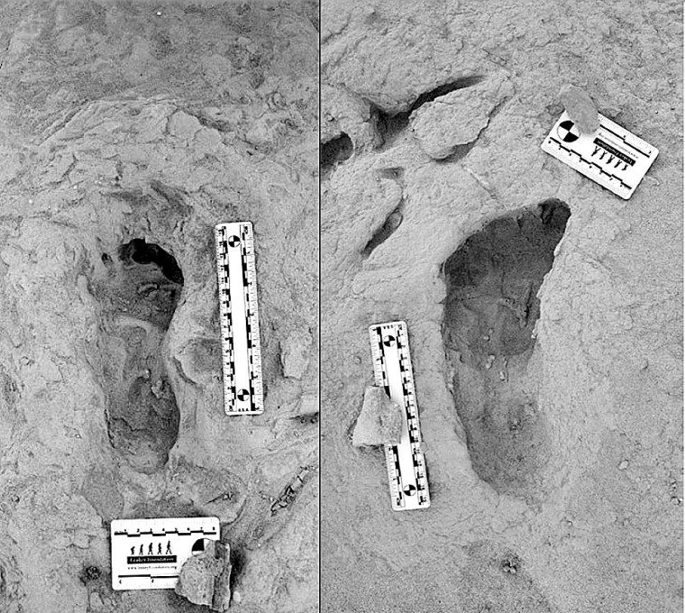
The Koobi Fora area near modern Lake Turkana has been an important, go-to site, courtesy of the Leakey palaeoanthropology dynasty (Louis and Mary, their son and daughter-in-law Richard and Meave, and granddaughter Louise). They discovered five hominin species there dating from 4.2 to 1.4 Ma. So there was a chance that this rich area might prove that two of the species were close neighbours in both space and time. In 2021 Kenyan members of the Turkana Basin Institute based in Nairobi spotted a trackway of human footprints on a bedding surface of sediments that had been deposited about 1.5 Ma ago. Reminiscent of the famous, 2 million years older Laetoli trackway of Australopithecus afarensis in Tanzania, that at Koobi Fora is scientifically just as exciting  for it shows footprints of two hominin species Homo erectus and Paranthropus boisei who had walked through wet mud a few centimetres below the surface of Lake Turkana’s ancient predecessor (Hatala, K.G. and 13 others, 2024. Footprint evidence for locomotive diversity and shared habitats among early Pleistocene hominins. Science, v. 386, p. 1004-1010; DOI: 10.1126/science.ado5275). The trackway is littered with the footprints of large birds and contains evidence of zebra.

One set of prints attributed to H. erectus suggest the heels struck the surface first, then the feet rolled forwards before pushing off with the soles: little different from our own, unshod footprints in mud. They are attributed to H. erectus. The others also show a bipedal gait, but different locomotion. The feet that made them were significantly flatter than ours and had a big toe angled away from the smaller toes. They are so different that no close human relative could have made them. The local fossil record includes paranthropoids (Paranthropus boisei), whose fossil foot bones suggest an individual of that speciesmade those prints. It also turns out that a similar, dual walkers’ pattern was found 40 km away in lake sediments of roughly the same age. The two species cohabited the same terrain for a substantial period of time. As regards the Koobi Fora trackway, it seems the two hominins plodded through the mud only a few hours apart at most: they were neighbours.

Artists’ reconstructions of: left – H. erectus; right – Paranthropus boisei. Credits: Yale University, Roman Yevseyev respectively

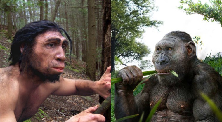
From their respective anatomies they were very different. Homo erectus was, apart from having massive brow ridges, similar to us. Paranthropus boisei had huge jaws and facial muscles attached to a bony skull crest. So how did they get along? The first was probably omnivorous and actively hunted or scavenged meaty prey: a bifacial axe-wielding hunter-gatherer. Paranthropoids seem to have sought and eaten only vegetable victuals, and some sites preserve bone digging sticks. They were not in competition for foodstuffs and there was no reason for mutual intolerance. Yet they were physically so different that intimate social relations were pretty unlikely. Also their brain sizes were very different, that of P. Boisei’s being far smaller than that of H. erectus , which may not have encouraged intellectual discourse. Both persist in the fossil record for a million years or more. Modern humans, Neanderthals and Denisovans, as we know, sometimes got along swimmingly, possibly because they were cognitively very similar and not so different physically.

Since many hominin fossils are associated with riverine and lake-side environments, it is surprising that more trackways than those of Laetoli and Koobi Fora have been found. Perhaps that is because palaeoanthropologists are generally bent on finding bones and tools! Yet trackways show in a very graphic way how animals behave and interrelate with their environment, for example dinosaurs. Now anthropologists have learned how to spot footprint trace fossils that will change, and enrich the human story.

See also: Ashworth, J. Fossil footprints of different ancient humans found together for the first time. Natural History Museum News 28 November 2024; Marshall, M. Ancient footprints show how early human species lived side by side. New Scientist, 28 November 2024

Divining the possible climatic impacts of slowing North Atlantic current patterns

Meltwater channels and lake on the surface of the Greenland ice sheet

In August 2024 Earth-Logs reported on the fragile nature of thermohaline circulation of ocean water. The post focussed on the Atlantic Meridional Overturning Circulation (AMOC), whose fickle nature seems to have resulted in a succession of climatic blips during the last glacial-interglacial cycle since 100 ka ago. They took the form of warming-cooling cycles known as Dansgaard-Oeschger events, when the poleward movement of warm surface water in the North Atlantic Ocean was disrupted. An operating AMOC normally drags northwards warm water from lower latitudes, which is more saline as a result of evaporation from the ocean surface there. Though it gradually cools in its journey it remains warmer and less dense than the surrounding surface water through which it passes: it effectively ‘floats’. But as the north-bound, more saline stream steadily loses energy its density increases. Eventually the density equals and then exceeds that of high-latitude surface water, at around 60° to 70°N, and sinks. Under these conditions the AMOC is self-sustaining and serves to warm the surrounding land masses by influencing climate. This is especially the case for the branch of the AMOC known as the Gulf Stream that today swings eastwards to ameliorate the climate of NW Europe and Scandinavia as far as Norway’s North Cape and into the eastern Arctic Ocean.

The suspected driving forces for the Dansgaard-Oeschger events are sudden massive increases in the supply of freshwater into the Atlantic at high northern latitudes, which dilute surface waters and lower their density. So it becomes more difficult for surface water to become denser on being cooled so that it can sink to the ocean floor. The AMOC may weaken and shut down as a result and so too its warming effect at high latitudes. It also has a major effect on atmospheric circulation and moisture content: a truly complicated climatic phenomenon. Indeed, like the Pacific El Niño-Southern Oscillation (ENSO), major changes in AMOC may have global climatic implications.  QIyun Ma of the Alfred Wegner Institute in Bremerhaven, Germany and colleagues from Germany, China and Romania have modelled how the various possible locations of fresh water input may affect AMOC (Ma, Q. et al. 2024. Revisiting climate impacts of an AMOC slowdown: dependence on freshwater locations in the North Atlantic. Science Advances, v. 10, article eadr3243; DOI: 10.1126/sciadv.adr3243). They refer to such sudden inputs as ‘hosing’!

Location of the 4 regions in the northern North Atlantic used by Ma et al. in their modelling of AMOC: A Labrador Sea; B Irminger Basin; C NE Atlantic; D Nordic Seas. Colour chart refers to current temperature. Solid line – surface currents, dashed line – deep currents

First, the likely consequences under current climatic conditions of such ‘hosings’ and AMOC collapses are: a rapid expansion of the Arctic Ocean sea ice; delayed onset of summer ice-free conditions; southward shift of the Intertropical Convergence Zone (ITCZ) –  a roughly equatorial band of low pressure where the NE and SE trade winds converge, and the rough location of the sometimes windless Doldrums. There have been several attempts to model the general climatic effects of an AMOC slowdown. Ma et al. take matters a step further by using the Alfred Wegener Institute Climate Model (AWI-CM3) to address what may happen following ‘hosing’ in four regions of the North Atlantic: the Labrador Sea (between Labrador and West Greenland); the Irminger Basin (SE of East Greenland, SW of Iceland); the Nordic Seas (north of Iceland; and the Greenland-Iceland-Norwegian seas) and the NE Atlantic (between Iceland, Britain and western Norway).

Prolonged freshwater flow into the Irminger Basin has the most pronounced effect on AMOC weakening, largely due to a U-bend in the AMOC where the surface current changes from northward to south-westward flow parallel to the East Greenland Current. The latter carries meltwater from the Greenland ice sheet whose low density keeps it near the surface. In turn, this strengthens NE and SW winds over the Labrador Sea and Nordic Seas respectively, which slow this part of the AMOC. In turn that complex system slows the entire AMOC further south. Since 2010 an average 270 billion tonnes of ice has melted in Greenland each year. This results in an annual 0.74 mm rise in global sea level, so the melted glacial ice is not being replenished. When sea ice forms it does not take up salt and is just as fresh as glacial ice. Annual melting of sea ice therefore temporarily adds fresh water to surface waters of the Arctic Ocean, but the extent of winter sea ice is rapidly shrinking. So, it too adds to freshening and lowering the density of the ocean-surface layer. The whole polar ocean ‘drains’ southwards by surface currents, mainly along the east coast of Greenland potentially to mix with branches of the AMOC. At present they sink with cooled more saline water to move at depth. To melting can be added calving of Greenlandic glaciers to form icebergs that surface currents transport southwards. A single glacier (Zachariae Isstrom) in NE Greenland lost 160 billion tonnes of ice between 1999 and 2022. Satellite monitoring of the Greenland glaciers suggests that a trillion tonnes have been lost through iceberg formation during the first quarter of the 21st century. Accompanying the Dansgaard-Oeschger events of the last 100 ka were iceberg ‘armadas’ (Heinrich events) that deposited gravel in ocean-floor sediments as far south as Portugal.

 The modelling done by Ma et al. also addresses possible wider implications of their ‘hosing’ experiments to the global climate. The authors caution that this aspect is an ‘exploration’ rather than prediction. Globally increased duration of ‘cold extremes’ and dry spells, and the intensity of precipitation may ensue from downturns and potential collapse of AMOC. Europe seems to be most at risk. Ma et al. plea for expanded observational and modelling studies focused on the Irminger Basin because it may play a critical role in understanding the mechanisms and future strength of the AMOC.

 See also: Yirka, R. 2024. Greenland’s meltwater will slow Atlantic circulation, climate model suggests. Phys Org, 21 November 2024

A major breakthrough in carbon capture and storage?

Carbon capture and storage is in the news most weeks and is increasingly on the agenda for some governments. But plans to implement the CCS approach to reducing and stopping global warming increasingly draws scorn from scientists and environmental campaigners. There is a simple reason for their suspicion. State engagement, in the UK and other rich countries, involves major petroleum companies that developed the oil and gas fields responsible for unsustainably massive injection of CO2 into the atmosphere. Because they have ‘trousered’ stupendous profits they are a tempting source for the financial costs of pumping CO2 into porous sedimentary rocks that once contained hydrocarbon reserves. Not only that, they have conducted such sequestration over decades to drive out whatever petroleum fluids remaining in previously tapped sedimentary strata. For that second reason, many oil companies are eager and willing to comply with governmental plans, thereby seeming to be environmentally ‘friendly’. It also tallies with their ambitions to continue making profits from fossil-fuel extraction. But isn’t that simply a means of replacing the sequestered greenhouse gas with more of it generated by burning the recovered oil and natural gas; i.e. ‘kicking the can down the road’? Being a gas – technically a ‘free phase’ – buried CO2 also risks leaking back to the atmosphere through fractures in the reservoir rock. Indeed, some potential sites for its sequestration have been deliberately made more gas-permeable by ‘fracking’ as a means of increasing the yield of petroleum-rich rock. Finally, a litre of injected gas can drive out pretty much the same volume of oil. So this approach to CCS may yield a greater potential for greenhouse warming than would the sequestered carbon dioxide itself.

Image of calcite (white) and chlorite (cyan) formed in porous basalt due to CO2-charged water-rock interaction at the CarbFix site in Iceland. (Credit: Sandra Ósk Snæbjörnsdóttir)

Another, less widely publicised approach is to geochemically bind CO2 into solid carbonates, such as calcite (CaCO­3), dolomite (CaMgCO3), or magnesite (MgCO3). Once formed such crystalline solids are unlikely to break down to their component parts at the surface, under water or buried. One way of doing this is by the chemical weathering of rocks that contain calcium- and magnesium-rich minerals, such as feldspar (CaAl2Si2O8), olivine ([Fe,Mg]2SiO4) and pyroxene ([Fe,Mg]CaSi2O6) . Mafic and ultramafic rocks, such as basalt and peridotite are commonly composed of such minerals. One approach involves pumping the gas into a Icelandic borehole that passes through basalt and letting natural reactions do the trick. They give off heat and proceed quickly, very like those involved in the setting of concrete. In two experimental field trials 95% of injected CO2 was absorbed within 18 months. Believe it or not, ants can do the trick with crushed basalt and so too can plant roots. There have been recent experiments aimed at finding accelerants for such subsurface weathering (Wang, J. et al. 2024. CO2 capture, geological storage, and mineralization using biobased biodegradable chelating agents and seawater. Science Advances, v. 10, article eadq0515; DOI: 10.1126/sciadv.adq0515). In some respects the approach is akin to fracking. The aim is to connect isolated natural pores to allow fluids to permeate rock more easily, and to release metal ions to combine with injected CO2.

Chelating agents are biomolecules that are able to dissolve metal ions; some are used to remove toxic metals, such as lead, mercury and cadmium, from the bodies of people suffering from their effects. Naturally occurring ones extract metal ions from minerals and rocks and are agents of chemical weathering; probably used by the aforesaid ants and root systems. Wang and colleagues, based at Tohoku University in Japan, chose a chelating agent GLDA (tetrasodium glutamate diacetate –  C9H9NNa4O8) derived from plants, which is non-toxic, cheap and biodegradable. They injected CO2 and seawater containing dissolved GDLA into basaltic rock samples. The GDLA increases the rock’s porosity and permeability by breaking down its minerals so that Ca and Mg ions entered solution and were thereby able to combine with the gas to form carbonate minerals. Within five days porosity was increased by 16% and the rocks permeability increased by 26 times. Using electron microscopy the authors were able to show fine particles of carbonate growing in the connected pores. In fact these carbonate aggregates become coated with silica released by the induced mineral-weathering reactions. Calculations based on the previously mentioned field experiment in Iceland suggest that up to 20 billion tonnes of CO2 could be stored in 1.3 km3 of basalt treated in this way: about 1/25000 of the active rift system in Iceland (3.3 x 10⁴ km2 covered by 1 km of basalt lava). In 2023 fossil fuel use emitted an estimated 36.6 bllion tons of CO2 into the atmosphere.

So, why do such means of efficiently reducing the greenhouse effect not receive wide publicity by governments or the Intergovernmental Panel on Climate Change? Answers on a yellow PostIt™ please . . .

The prospect of climate chaos following major volcano eruptions

It hardly needs saying that volcanoes present a major hazard to people living in close proximity. The inhabitants of the Roman cities of Herculaneum and Pompeii in the shadow of Vesuvius were snuffed out by an incandescent pyroclastic during the 79 CE eruption of the volcano. Since December 2023 long-lasting eruptions from the Sundhnúksgígar crater row on the Reykjanes Penisula of Iceland have driven the inhabitants of nearby Grindavík from their homes, but no injuries or fatalities have been reported. Far worse was the 1815 eruption of Tambora on Sumbawa, Indonesia, when at least 71,000 people perished. But that event had much wider consequences, which lasted into 1817 at least. As well as an ash cloud the huge plume from Tambora injected 28 million tons of sulfur dioxide into the stratosphere. In the form of sulfuric acid aerosols, this reflected so much solar energy back into space that the Northern Hemisphere cooled by 1° C, making 1816 ‘the year without a summer’. Crop failures in Europe and North America doubled grain prices, leading to widespread social unrest and economic depression. That year also saw unusual weather in India culminate in a cholera outbreak, which spread to unleash the 1817 global pandemic. Tambora is implicated in a global death toll in the tens of millions. Thanks to the record of sulfur in Greenland ice cores it has proved possible to link past volcanic action to historic famines and epidemics, such as the Plague of Justinian in 541 CE. If they emit large amounts of sulfur gases volcanic eruptions can result in sudden global climatic downturns.

The ash plume towering above Pinatubo volcano in the Philippines on 12 June 1991, which rose to 40 km (Credit: Karin Jackson U.S. Air Force)

With this in mind Markus Stoffel, Christophe Corona and Scott St. George of the University of Geneva, Switzerland, CNRS, Grenoble France and global insurance brokers WTW, London, respectively, have published a Comment in Nature warning of this kind of global hazard (Stoffel, M., Corona, C. & St. George, S. 2024.  The next massive volcano eruption will cause climate chaos — we are unprepared. Nature v. 635, p. 286-289; DOI: 10.1038/d41586-024-03680-z). The crux of their argument is that there has been nothing approaching the scale of Tambora for the last two centuries. The 1991 eruption of Pinatubo fed the stratosphere with just over a quarter of Tambora’s complement of SO2, and decreased global temperatures by around 0.6°C during 1991-2. Should one so-called Decade Volcanoes – those located in densely populated areas, such as Vesuvius – erupt within the next five years actuaries at Lloyd’s of London estimate economic impacts of US$ 3 trillion in the first year and US$1.5 trillion over the following years. But that is based on just the local risk of ash falls, lava and pyroclastic flows, mud slides and lateral collapse, not global climatic effects. So, a Tambora-sized or larger event is not countenanced by the world’s most famous insurance underwriter: probably because its economic impact is incalculable. Yet the chances of such a repeat certainly are conceivable. A 60 ka record of sulfate in the Greenland ice cores allows the probability of eruptions on the scale of Tambora to be estimated. The data suggest that there is a one-in-six chance that one will occur somewhere during the 21st century, but not necessarily at a site judged by volcanologists to be precarious . Nobody expected the eruption from the Pacific Ocean floor of the Hunga Tonga-Hunga Ha’apai volcano on January 15, 2022: the largest in the last 30 years.

The authors insist that climate-changing eruptions now need to be viewed in the context of anthropogenic global warming. Superficially, it might seem that a few volcanic winters and years without a summer could be a welcome, albeit short-term, solution. However, Stoffel, Corona and St. George suggest that the interaction of a volcano-induced global cooling with climatic processes would probably be very complex. Global warming heats the lower atmosphere and cools the stratosphere. Such steady changes will affect the height to which explosive volcanic plumes may reach. Atmospheric circulation patterns are changing dramatically as the weather of 2024 seems to show. The same may be said for ocean currents that are changing as sea-surface temperatures increase. Superimposing volcano-induced cooling of the sea surface adds an element of chaos to what is already worrying. What if a volcanic winter coincided with an el Niño event? The Intergovernmental Panel on Climate Change that projects climate changes is ‘flying blind’ as regards volcanic cooling. Another issue is that our knowledge of the effects in 1815 of Tambora concerned a very different world from ours: a global population then that was eight times smaller than now; very different patterns of agriculture and habitation; a world with industrial production on a tiny proportion of the continental surface. Stoffel, Corona and St. George urge the IPCC to shed light on this major blind spot. Climate modellers need to explore the truly worst-case scenarios since a massive volcanic eruption is bound to happen one day. Unlike global warming from greenhouse-gas emission, there is absolutely nothing that can be done to avert another Tambora.

How India accelerated towards Eurasia at the end of the Cretaceous

About 70 Ma ago the magnetic striping of the Indian Ocean floor suggests that the Indian subcontinent was then moving towards the huge, almost stationary Eurasian continent at about 8 cm per year. Over the next 5 Ma this convergence rate underwent a tectonically startling acceleration to reach 18 cm yr-1 by around the time of the Cretaceous-Palaeogene boundary (65 Ma): more than doubling the approach rate. Thereafter it slowed, eventually to a few centimetres per year once collision and building of the Himalayan mountain belt were more or less complete about 30 Ma ago. This cannot easily be explained by a speeding up of the sea-floor spreading rate at an Indian Ocean ridge to the south, 18 cm yr-1 being as fast as tectonic forces can manage at present. At that time ocean floor to the north of India was being subducted beneath Eurasia, and basaltic volcanism was flooding what is now the Deccan Plateau on western India. A couple of suggestions have been made: two northward subduction zones may have developed or the mantle plume feeding the Deccan flood basalts may have driven the tectonic acceleration. A third possibility is that the subduction was somehow lubricated. That approach has recently been considered by geoscientists from China and Singapore  (Zhou, H. et al. 2024. India–Eurasia convergence speed-up by passive-margin sediment subduction. Nature, v. 635, p. 114-120; DOI: 10.1038/s41586-024-08069-6).

Hao Zhou and colleagues studied the isotopic and trace-element geochemistry of volcanic and plutonic igneous complexes to the north of the Himalaya. They were emplaced in arc environments in three stages: from 98 to 89; 65 to 60; and 57 to 50 Ma. In this tectonic setting fluids rise from the subducted slab to induce the mantle part of the overriding lithosphere to partially melt. That yields magmas which penetrate the crust above. The first and last magmatic events produced similar isotopic and trace-element ‘signatures’, which suggest fluids rose from subducted ocean lithosphere.  But those in the latest Cretaceous to earliest Palaeocene are markedly different. Instead of showing signs of their magmas being entirely mantle derived like the earlier and later groups, the 65 to 60 Ma rocks exhibit clear evidence of partial melting having incorporated materials that had originated in older continental crust. The authors suggest that this crustal contamination stemmed from sediments that had been deposited at the northern margin of the Indian subcontinent during the Mesozoic. These sediments had formed by weathering of the ancient rocks that underpin India, transport of the debris by rivers and deposition on the seafloor as water-saturated sands, silts and clays. Once those sediments were subducted beneath what is now Tibet they would yield fluids with a geochemical ‘fingerprint’ inherited from old continental crust. Moreover, far more fluids than subducted oceanic crust could ever release would rise into the overriding lithosphere than.

The fluids rising from a subducted wedge of sediments may have reduced friction between the overriding Eurasian lithosphere and the subducted slab derived from the Indian tectonic plate. That scenario would not only have lubricated subduction, but allowed compressive forces in the overriding lithosphere to relax. Both would have allowed convergence of the two plates to move significantly faster as the sediments were progressively consumed. Once completed, convergence would have slowed without such ‘lubrication’.Earlier continent-continent collision zones, such as those that united Pangaea and older supercontinents may well have involved such tectonic surges. And the same kind of process may eventually speed up the reassembly of the latest distribution of continents.

Watch an animation of the India-Eurasia convergence (just over 3 minutes long)compiled by Christopher Scotese of Northwestern University in Evanston, Illinois, USA, which is a component of his Paleomap Project. It starts by following India from its current position to its origin in the break-up of Gondwanaland ~100 Ma ago. The last half reverses the motions to show India’s slow collision with Eurasia.