Geochemical evidence for the origin of eukaryotes

Along with algae, jellyfish, oak trees, sharks and nearly every organism that can be seen with the naked eye, we are eukaryotes. The cells of every member of the Eukarya, one of the three great domains of life, all contain a nucleus – the main location of genetic material – and a variety of other small bodies known as organelles, such as the mitochondria of animals and the chloroplasts of plant cells. The vast bulk of organisms that we can’t see unaided are prokaryotes, divided into the domains of Bacteria and Archaea. Their genetic material floats around in their cells’ fluid. The DNA of eukaryotes shares some stretches with prokaryotes, but no prokaryotes contain any eukaryote genetic material. This suggests that the Eukarya arose after the Bacteria and Archaea, and also that they are a product of evolution from prokaryotes, probably by several combining in symbiotic relationships inside a shared cell membrane. Earth-logs has followed developments surrounding this major issue since 2002, as reflected in some of the posts linked to what follows. 

While prokaryotes can live in every conceivable environment at the Earth’s surface and even in a few kilometres of crust beneath, the vast majority of eukaryotes depend on free oxygen for their metabolism. Logically, the earliest of the Eukarya could only have emerged when oxygen began to appear in the oceans following the Great Oxidation Event around 2.4 billion years ago. That is more than a billion years after the first prokaryotes had left their geological signature in the form of curiously bulbous, layered carbonate structures (stromatolites), probably formed by bacterial mats. The oldest occur in the Archaean rocks of Western Australia as far back as 3.5 Ga, and disputed examples have been found in the 3.7 Ga Isua sediments of West Greenland. The oldest of them are thought to have been produced through the anoxygenic photosynthesis of purple bacteria (See: Molecular ‘fossils’ and the emergence of photosynthesis; September 2000), suggested by organic molecules found in kerogen from early Archaean sediments. Later stromatolites (<3.0 Ga) have provided similar evidence for oxygen-producing cyanobacteria.

Acritarchs are microfossils of single-celled organisms made of kerogen that have been found in sediments up to 1.8 billion years old. Features protruding from their cell walls distinguish them from prokaryote cells, which are more or less ‘smooth’: acritarchs have been considered as possible early eukaryotes. Yet the oldest undisputed eukaryote microfossils – red and green algae – are much younger (about 1.0 Ga). A means of estimating an age for the crown group from which every later eukaryote organism evolved – last eukaryotic common ancestor (LECA) – is to use an assumed rate of mutation in DNA to deduce the time when differences in genetics between living eukaryotes began to diverge: i.e. a ‘molecular clock’. This gives a time around 2 Ga ago, but the method is fraught with uncertainties, not the least being the high possibility of mutation rates changing through time. So, when the Eukarya arose is blurred within the so-called ‘boring billion’ of the early Proterozoic Eon. A way of resolving this uncertainty to some extent is to look for ‘biomarker’ chemicals in the geological record that provide a ‘signature’ for eukaryotes.

A new study has been undertaken by a group of Australian, German and French scientists to analyse sediments ranging in age from 635 to 1640 Ma from Australia, China, Asia, Africa, North and South America (Brocks, J.J and 9 others 2023. Lost world of complex life and the late rise of the eukaryotic crown. Nature, v. 618, p. 767–773; DOI: 10.1038/s41586-023-06170-w; contact for PDF). Their chosen biomarkers are sterols (steroids) that regulate eukaryote cell membranes. Some prokaryotes also synthesise steroids but all of them produce hopanepolyols (hopanoids), which eukaryotes do not. The key measures for the presence/absence of eukaryote remains in ancient sea-floor sediments is thus the relative proportions of preserved steroids and hopanoids, together with those for the breakdown products of both – steranes and hopanesthat are, crudely speaking, carbon ‘skeletons’ of the original chemicals.

Proportions of biomarkers in sediments from present to 1.64 Ga. Cholesteroids – reds; ergosteroids – blues; stigmasteroids – greens; protosteroids magentas, hopanoids – yellows; unsampled – grey. Snowball glaciations are shown in pale blue. (Credit: Simplified from Figure 3 in Brocks et al.)

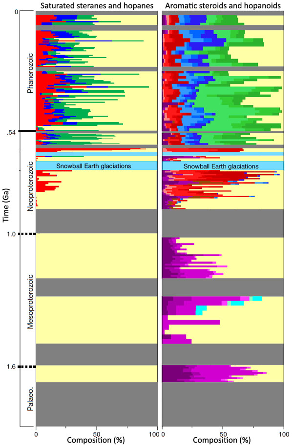
Interpretation of the results by Jochen Brocks and colleagues is complicated, and what follows is a summary based partly on an accompanying Nature News & Views article(Kenig, F. 2023. The long infancy of sterol biosynthesis. Nature, v. 618, p. 678-680; DOI: 10.1038/d41586-023-01816-1). The conclusions of Brocks et al. are surprising. First, the break-down products of steroids (saturated steranes) that can be attributed to crown eukaryotes (left on the figure above) are only present in sediments going back to about 200 Ma before the first Snowball Earth event (~900 Ma). Before that only hopanes formed by hopanoid degradation are present: a suggestion that LECA only appeared around that time – the authors suggest sometime between 1 and 1.2 Ga. That is far later than the time when eukaryotes could have emerged: i.e. once there was available oxygen after the Great Oxidation Event (~2.4 to 2.2 Ga). So what was going on before this? The authors broke new ground in analysis of biomarkers by being able to detect signs of the presence of actual hopanoids and steroids of several different kinds. Steroids were present as far back as 1.6 Ga in the oldest sediments that were analysed.

Steroids of crown eukaryotes are represented by cholesteroids, ergosteroids and stigmasteroids. All three are present throughout the Phanerozoic Eon and into the time of the Ediacaran Fauna that began 630 Ma ago. In that time span they generally outweigh hopanoids, thus reflecting the dominance of eukaryotes over prokaryotes. Back to about 900 Ma, only cholesteroids are present, together with archaic forms that are not found in living Eukarya, termed protosteroids.  Before that, only protosteroids are found. Moreover, these archaic steroids are not present in sediments that follow the Snowball Earth episodes (the Cryogenian Period).

Thus, it is possible that crown group eukaryotes – and their descendants, including us – evolved from and completely replaced an earlier primitive form (acritarchs?) at around the time of the greatest climatic changes that the Earth had experienced in the previous billion years or more. Moreover, the Cryogenian and Ediacaran Periods seem to show a rapid emergence of stigmasteroid- and ergosteroid production relative to cholesteroid: perhaps a result of explosive evolution of the Eukarya at that time. The organisms that produced protosteroids were present in variable amounts throughout the Mesoproteroic. Clearly there need to be similar analyses of sediments going back to the Great Oxygenation Event and the preceding Archaean to see if the protosteroid producers arose along with increasing levels of molecular oxygen. The ‘boring billion’ (2.0 to 1.0 Ga) may well be more interesting than previously thought.

Early modern human fossils from a Laotian cave and the eastward ‘out-of-Africa’ migration

Finding human fossils in SE Asia is rare because its tropical climate generally results in decomposition of bones. Up to now the oldest known anatomically modern human (AMH) found beyond the Middle East is from Australia and has been dated to 65 ka. Other, less convincing candidates for the earliest appearance of AMH in Asia are scattered teeth found in Chinese caves that yielded dates of up to 139 ka: their assignment to AMH and the reliability of their dating are disputed. Now a large team of scientists from the USA, Germany, Australia, South Africa, France, Denmark and Laos have unearthed convincing but fragmented AMH bones among a jumble of diverse animal fossils in sediment flooring Tam Pà Ling cave  in northern Laos (Friedline, S.E. and 30 others 2023. Early presence of Homo sapiens in Southeast Asia by 86–68 kyr at Tam Pà Ling, Northern Laos. Nature Communications, v. 14, article 3193; DOI: 10.1038/s41467-023-38715-y). Several dating techniques reveal ages of the AMH samples that range from 46 to 77 ka, and potentially as far back as 86 ka. It is conceivable that the oldest are from the population that subsequently reached Australia. Far to the west of Laos in Greece, Israel and Arabia an earlier AMH presence goes back as far as 90 to 210 ka. Moreover, palaeoclimatic studies suggest many opportunities for eastward migration since 290 ka ago that AMH emigrants may have exploited. Once beyond regions around Arabia and the Gulf, which were periodically hyperarid, the journey to the rest of Asia was probably continuously habitable throughout the last two glacial-interglacial cycles.

Entrance to Tam Pà Ling cave in northern Laos (credit: Demeter et al.; Fig S1)

Another aspect of the AMH record in southern and SE Asia is that the individuals represented seem to have been anatomically very varied (Demeter, F. et al. 2023. Early Modern Humans and Morphological Variation in Southeast Asia: Fossil Evidence from Tam Pa Ling, LaosPLOS ONE, v. 10, article e0121193. DOI:10.1371/journal.pone.0121193). This may suggest that migration was by significantly different groups at different times. Oddly, the earliest known examples have more ‘modern’ characteristics than younger ones that appear somewhat ‘archaic’. The age of the fossils conflicts with the 60 ka age reconstructed from genetic evidence for the main diffusion across Eurasia and Australasia. One possibility is that there were several pre-60 ka migrations, descendents of these early populations having been replaced or assimilated by a later, larger numbers of AMH migrants. At 74 ka the Sumatran Toba supervolcano erupted about 2,800 km3 of ash to blanket a vast area and cause global cooling that could have more than decimated migrating AMH groups. Alternatively the 60 ka ‘genetics’ date is not correct, as suggested by the minimum date of 65 ka for the earliest Australians. Such a conflict of evidence will surely spur further excavation: as one researcher observed about Laos, ‘There are thousands of caves to explore’.

See also: Coleman, J. 2023. Laos cave fossils prompt rethink of human migration map. Nature, v.618; DOI: 10.1038/d41586-023-01903-3; Ashworth, J. 2023. Fossils reveal early modern humans in southeast Asia 77,000 years ago. Natural History Museum’s Discover, 15 June 2023.

Did Precambrian BIFs ‘fall’ into the mantle to trigger mantle plumes?

How the Earth has been shaped has depended to a large extent on a very simple variable among rocks: their density. Contrasts in density between vast rock masses are expressed when gravity attempts to maintain a balance of forces. The abrupt difference in elevation of the solid surface at the boundaries of oceans and continents – the Earth’s hypsometry – stems from the contrasted densities of continental and oceanic crust: the one dominated by granitic rocks (~2.8 t m-3) the other by those of basaltic composition (~ 3.0 t m-3). Astronomers have estimated that Earth’s overall density is about 5.5 t m-3 – it is the densest planet in the Solar System. The underlying mantle makes up 68% of Earth’s mass, with a density that increases with depth from 3.3 to 5.4 t m-3 in a stepwise fashion, at a number of discontinuities, because mantle minerals undergo changes induced by pressure. The remaining one third of Earth’s mass resides in the iron-nickel core at densities between 9.5 to 14.5 t m-3. Such density layering is by no means completely stable. Locally increased temperatures in mantle rocks reduce their density sufficiently for masses to rise convectively to be replaced by cooler ones, albeit slowly. By far the most important form of convection affecting the lithosphere involves the resorption of oceanic lithosphere plates at destructive margins, which results in subduction. This is thought to be due to old, cold oceanic basalts undergoing metamorphism as pressure increases during subduction. They are transformed at depth to a mineral assemblage (eclogite) that is denser (3.4 to 3.5 t m-3) than the enveloping upper mantle. That density contrast is sufficient for gravity to pull slabs of oceanic lithosphere downwards. This slab-pull force is transmitted through oceanic lithosphere that remains at the surface to become the dominant driver of modern plate tectonics. As a result, extension of the surface oceanic lithosphere at constructive margins draws mantle upwards to partially melt at reduced pressure, thus adding new basaltic crust at mid-ocean rift systems to maintain a form of mantle convection. Seismic tomography shows that active subducted slabs become ductile about 660 km beneath the surface and below that no earthquakes are detected. Quite possibly, the density of the reconstituted lithospheric slab becomes less than that of the mantle below the 660 km discontinuity. So the subducted slab continues by moving sideways and buckling in response to the ‘push’ from its rigid upper parts above. But it has been suggested that some subducted slabs do finally sink to the core-mantle boundary, but that is somewhat conjectural.

Typical banded iron formation

There are sedimentary rocks whose density at the surface exceeds that of the upper mantle: banded iron formations (BIFs) that contain up to 60% iron oxides (mainly Fe2O3) and have an average density at the surface of around 3.5 t m-3. BIFs formed mainly in the late Archaean and early Proterozoic Eons  (3.2 to 1.0 Ga) and none are known from the last 400 Ma. They formed when soluble iron-2 (Fe2+) – being added to ocean water by submarine hydrothermal activity –was precipitated as Fe3+ in the form of iron oxide (Fe2O3) where oxygen was present in ocean water. With little doubt this happened only in shallow marine basins where cyanobacteria that appeared about 3.5 Ga ago had sufficient sunlight to photosynthesise. Until about 2.4 Ga the atmosphere and thus the bulk of ocean water contained very little oxygen so the oceans were pervaded by soluble iron so that BIFs were able to form wherever such biological activity was going on. Conceivably (but not proven), that BIF-forming biochemical reaction may even have operated far from land in ocean surface water, slowly to deposit Fe2O3 on the deep ocean floor. After 2.4 Ga oxygen began to build in the atmosphere after the Great Oxidation Event had begon. That time was also when the greatest production of BIFs took place. Strangely, the amount of BIF in the geological record fell during the next 600 Ma to rise again to a very high peak at 1.8 Ga. Since there must have been sufficient soluble iron and an increasing amount of available oxygen for BIFs to form throughout that ‘lean’ period the drop in BIF formation is paradoxical. After 1.0 Ga BIFs more or less disappear. By then so much oxygen was present in the atmosphere and from top to bottom in ocean water that soluble iron was mostly precipitated at its hydrothermal source on the ocean floor. Incidentally, modern ocean surface water far from land contains so little dissolved iron that little microbiological activity goes on there: iron is an essential nutrient so the surface waters of remote oceans are effectively ‘wet deserts’.

Plots of probability of LIPs and BIFs forming at the Earth’s surface during Precambrian times, based on actual occurrences (Credit: Keller, et al., modified Fig 1A)

Spurred by the fact that if a sea-floor slab dominated by BIFs was subducted it wouldn’t need eclogite formation to sink into the mantle, Duncan Keller of Rice University in Texas and other US and Canadian colleagues have published a ‘thought experiment’ using time-series data on LIPs and BIFs compiled by other geoscientists (Keller, D.S. et al. 2023. Links between large igneous province volcanism and subducted iron formations. Nature Geoscience, v. 16, article; DOI: 10.1038/s41561-023-01188-1.). Their approach involves comparing the occurrences of 54 BIFs through time with signs of activity in the mantle during the Palaeo- and Mesoproterozoic Eras, as marked by large igneous provinces (LIPs) during that time span. To do this they calculated the degree of correlation in time between BIFs and LIPs. The authors chose a minimum area for LIPs of 400 thousand km2 – giving a total of 66 well-dated examples. Because the bulk of Precambrian flood-basalt provinces, such as occurred during the Phanerozoic, have been eroded away, most of their examples are huge, well-dated dyke swarms that almost certainly fed such plateau basalts. Rather than a direct time-correlation, what emerged was a match-up that covered 74% of the LIPs with BIFs that had formed about 241 Ma earlier. They also found a less precise correlation between LIPs associated with 241 Ma older BIFs and protracted periods of stable geomagnetic field, known as ‘superchrons’. These are thought by geophysicists to be influenced by heat flow through the core-mantle boundary (CMB).

The high bulk density of BIFs at the surface would be likely to remain about 15 % greater than that of peridotite as pressure increased with depth in the mantle. Such slabs could therefore penetrate the 660 mantle discontinuity. Their subduction would probably result in their eventually ‘piling up’ in the vicinity of the CMB. The high iron content of BIFs may also have changed the way that the core loses heat, thereby triggering mantle plumes. Certainly, there is a complex zone of ultra-low seismic velocities (ULVZ) that signifies hot, ductile material extending above the CMB. Because BIFs’ high iron-content makes them thermally highly conductive compared with basalts and other sediments, they may be responsible. Clearly, Keller et al’s hypothesis is likely to be controversial and they hope that other geoscientists will test it with new or re-analysed geophysical data. But the possibility of BIFs falling to the base of the mantle spectacularly extends the influence of surface biological processes to the entire planet. And, indeed, it may have shaped the later part of its tectonic history having changed the composition of the deep mantle. The interconnectedness of the Earth system also demands that the consequences – plumes and large igneous provinces – would have fed back to the Precambrian biosphere. See also: Iron-rich rocks unlock new insights into Earth’s planetary history, Science Daily, 2 June 2023

New drill core penetrates the Mohorovičić Discontinuity (the ‘Moho’)

In 1909 Croatian geophysicist Andrija Mohorovičić examined seismograms of a shallow earthquake that shook the area around Zagreb. To his surprise the by-then familiar time sequence of P-waves followed by the slower S-waves appeared twice on seismic records up to 800 km away. The only explanation that he could come up with was that the first arrivals had travelled directly through the crust to the detector whereas the second set must have followed a longer path: it had travelled downwards to be refracted to reach the surface when it met rocks denser than those at the surface. His analysis revealed a sharp boundary between the Earth’s crust and its mantle at a depth of about 54 km below what was then Yugoslavia. Later workers confirmed this discovery and honoured its discoverer by naming it the Mohorovičić Discontinuity. Difficulty with pronouncing his name resulted in a geological nickname: ‘the Moho’. It can be detected everywhere: at 20 to 90 km beneath the continental surface and 5 to 10 km beneath the ocean floor, thus distinguishing between continental and oceanic crust.

In the late 1950s accelerating geological and oceanographic research that would culminate in the theory of plate tectonics turned its focus on drilling down to the Moho in much the same way as a lust for space travel spawned getting to the Moon. The difference was that the proposers of what became known as the Mohole Project were members of what amounted to a geoscientific glee club (The American Miscellaneous Society), which included a member of the well-financed US National Science Foundation’s Earth Science Panel. The idea emerged shortly after the Soviet Union had launched the Sputnik satellite and rumours emerged that it was proposing deep drilling into the continental crust beneath the Kola Peninsula.  The Mohole’s initial target was the 3.9 km deep floor of the Caribbean off Guadalupe in Mexico and required advanced methods of stabilisation for a new oceanographic ship that was to host the drilling rig.

Huge (tens of metres high) pillars or ‘chimneys’ of carbonates formed by the Lost City hydrothermal vent near the mid-Atlantic ridge (Credit: ETH Zurich)

The Mohole was spudded in 1961, but the deepest of five holes reached only 200 m beneath the sea floor. It recovered Miocene sediments and a few metres of basalt. Deep water drilling was somewhat more complicated than expected and about US$ 57 million was spent fruitlessly. The project was disbanded in 1966 with considerable acrimony and schadenfreude. Nonetheless, the Mohole fiasco made technical advances and did demonstrate the feasibility of offshore drilling. The petroleum industry benefitted and so did oceanography with the globe-spanning deep-sea drilling of ocean floor sediments. The sediment cores produced the 200 million-year exquisitely detailed record of climate change and vast amounts of geochemical data from the basaltic oceanic crust. In 2005 JOIDES (the Joint Oceanographic Institutions for Deep Earth Sampling) had another crack at the Moho. That venture centred on the intersection of the Mid-Atlantic Ridge and the Atlantis Fracture Zone close to the ‘Lost City’ hydrothermal vent. The area around the vent is the site of a huge low-angled extensional fault that has partly dragged the basaltic ocean crust off the mantle beneath causing it to bulge. This provided an excellent opportunity to drill through the Moho. All went well, but 54 days of drilling yielded 1.4 km of basalt but nothing resembling mantle rock. So, again, the Moho had thwarted Science (and research economics). But finally it is beginning to reveal it secrets (see: Voosen, P. 2023. Ocean drillers exhume a bounty of mantle rocks. Science, v. 380 (News) p. 876-877; DOI: 10.1126/science.adi9899

The area around the ‘Lost City’ vent was originally chosen for drilling to examine the chemical processes going on there. Hydrogen emitted by serpentinisation of mantle rocks can combine with carbon monoxide in hydrothermal fluids to create a wide variety of organic compounds, which could be the initial building blocks for the origin of life. As part of the International Ocean Drilling Programme JOIDES decided to launch IODP Expedition 399 to re-examine the area around ‘Lost City’ in more detail. The expedition first tried to continue drilling the 2005 hole, but failed yet again. Finally a new drill site aimed at penetrating the extensional detachment. Within a few days the drill bit punched into mantle rocks and over a 6-week period the expedition had recovered a kilometre of core. The technical accounts for each week of drilling give a flavour of what it must be like to be a part of such a ship-borne expedition as well as describing what emerged in the drill core. It seems like a bit of a jumble, dominated by the mineral olivine– the principal characteristic of the ultramafic mantle – almost pure in the rock dunite and mixed with pyroxenes in various kinds of peridotite. There are also coarse-grained rocks that contain plagioclase feldspar, which cut through the ultramafic materials – gabbros, troctolites and norites.  They are relics of intrusive basaltic magmas that did not make it to the seabed. The samples are variably altered by interaction with watery hydrothermal fluids, with lots of serpentine, talc and even asbestos: the drilling presented a health hazard for a few days. The rocks have been metamorphosed under pressure-temperature conditions of greenschist to amphibolite facies and subject to ductile deformation, probably because of the effect of extensional deformation. Whatever, there is plenty of material to be analysed, including for signs of microbial activity. So, the dreams of a 1950s academic drinking fraternity (they were all men!) have finally been realised. But since those pre-plate-tectonic times many geologists have seen and collected much the same, even putting their index fingers on the Moho itself in the time-honoured fashion. Intricate 3-D geology in ophiolite complexes such as that in Oman, provide such opportunities at the much lower cost of air travel, Land Cruiser hire and camping. Indeed what we know of the structure of the oceanic lithosphere – pillow lavas, sheeted dyke complexes, gabbro cumulates and serpentinised ultramafic mantle – has come from such bodies thrust onto continental crust at ancient plate margins. So, why the celebration in this case? They are the first samples of mantle from young oceanic lithosphere; the rocks of ophiolites may not have formed at mid-ocean ridges. These should give clues to the long-term magmatism that has created the vast abyssal basins that the mantle eventually reabsorbs by subduction. Then, of course, there is the link to biogenic processes at constructive margins that underpinned the return to the active hydrothermal venting at ‘Lost City’.