Arctic warmer than now half a million years ago

Just over a month since evidence emerged that the Arctic Ocean was probably filled with fresh water from 150 to 131 and 70 to 62 thousand years ago (When the Arctic Ocean was filled with fresh water, February 2021), another study has shaken ‘received wisdom’ about Arctic conditions. This time it is about the climate in polar regions, and comes not from an ice core but speleothem or calcium carbonate flowstone that was precipitated on a cave wall in north-eastern Greenland. The existence of caves at about 80°N between 350 to 670 m above sea level in a very cold, arid area is a surprise in itself, for they require flowing water to form. The speleothem is up to 12 cm thick, but none is growing under modern, relatively warm conditions, cave air being below freezing all year. For speleothem to form to such an extent suggests a long period when air temperature was above 0°C. So was it precipitated before glacial conditions were established in pre-Pleistocene times?

Limestone caves in the arid Grottedal region of north-eastern Greenland (Credit: Moseley et al. 2021; Fig 2D)

A standard means of discovering the age of cave deposits, such as speleothem or stalagmites, is uranium-series dating (see: Irish stalagmite reveals high-frequency climate changes, December 2001). In this case the sheet of flowstone turned out to have been deposited between 588 to 537 thousand years ago; a 50 ka ‘window’ into conditions that prevailed during the middle part of 100 ka climatic cycling – about 6 glacial-interglacial stages before present. (Moseley, G.E. et al. 2021. Speleothem record of mild and wet mid-Pleistocene climate in northeast Greenland. Science Advances, v. 7, online article  eabe1260; DOI: 10.1126/sciadv.abe1260). Roughly half the layer formed during an interglacial, the rest under glacial conditions that followed. Detailed oxygen-isotope studies revealed that air temperatures during which calcium carbonate was precipitated were at least 3.5°C above those prevailing in the area at present; warm enough to melt local permafrost and to increase the summer extent of ice-free conditions in the Arctic Ocean, thereby encouraging greater rainfall. These warm and wet conditions correlate with increased solar heating over the North Atlantic region at that time, as suggested by modelling based on Milankovich astronomical forcing.

Unfortunately, the climate record derived from cores through the Greenland ice sheet only reaches back to about 120 ka, during the last interglacial period. So it is not possible to match the speleothem results to an alternative data set. Yet, thanks to the rediscovery of dirt cored from the very base of the deepest part of the ice sheet (beneath Camp Century) in a freezer in Denmark – it was discarded as interest focused on the record preserved in the ice itself – there is now evidence for complete melting of the ice sheet at some time in the past. The dirt contains abundant fossil plants. Analysing radioactive isotopes of aluminium and beryllium that formed in associated quartz grains as a result of cosmic ray bombardment when the area was ice-free suggests two periods of complete melting followed by glaciation , the second  being within the last million years.

The onshore Arctic climate is clearly more unstable than previously believed.

See also:  Geologists Find Million-Year-Old Plant Fossils Deep Beneath Greenland Ice Sheet. Sci News, 16 March 2021.

Where is Mars’s water?

A delta at the edge of Jazero Crater on Mars; definite evidence that water once flowed into the crater. Colours show different minerals in the delta sediments (credit: Brown University)

Early in the exploration of Mars using orbiting imaging systems it was easy to be sceptical about evidence for water being present at or near the surface of the Red Planet. Resolution was poor and some claims seemed to be wishful thinking or a sort of astronautical agitprop. For instance, gullies on steep slopes appeared so sharp that they must be forming continually, otherwise Mars’s periodic huge dust storms would have muted them. Some scientists claimed that they were signs of flowing water and even presented pictures from different overpasses that showed changes in them, such as darkening and small shifts in microtopography, which may have resulted from flowing water. Because Mars has a mean surface temperature of about -50°C that seems unlikely; at such extremes in Antarctica spit at the ground and it lands as ice. Nonetheless a bit of special pleading that deeply buried ice in Martian sediments might melt because of pressure gave the idea some traction.

A far more plausible explanation for the active gulley formation is that loose fine sediment can flow in the manner of a liquid, as it does in sand dunes on Earth (see: First signs of liquid water on Mars? June 2000). Yet as remotely sensed image coverage expanded and its resolution improved (currently about 50 cm) masses of evidence for drainage networks, signs of catastrophic floods and even glaciers (The glaciers of Mars, July 2003) emerged. Huge areas of the planet bore witness to a period in its past history – 4.1 to 3.8 billion years (Ga) ago – when it was a warm and wet planet. It has even been suggested that the flat, low-elevation northern hemisphere was the bed of a former ocean, covering about a third of Mars to a depth of about a kilometre. Now the planet has a hyperarid surface and a very thin atmosphere dominated by CO2, a little nitrogen and argon but almost no water vapour (~0.03%). Its poles are covered by ice caps whose extents fluctuate seasonally. They each have a core of permanent water ice, and seasonally expand and contract due to formation and sublimation of dry ice made of solid CO2. So what happened to Mars’s once abundant water?

One long-held theory is that water and most of Mars’s original atmosphere escaped to space. A suggested mechanism is the photo-dissociation of water to hydrogen and oxygen. Mars’s gravity cannot prevent hydrogen escape, which would leave an excess of atmospheric oxygen. One thing in abundance on the Martian surface is oxygen combined in iron oxides (Fe2O3); hence its red coloration. This hematite may have formed during chemical weathering of surface rocks and sediments during the wet phase, which released Fe2+ ions that were immediately oxidised by the hyper-oxygenated atmosphere that resulted from photo-dissociation. But there is another plausible explanation …

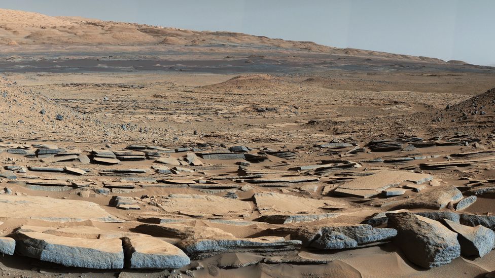
The lake-bed sediments of Gale Crater on Mars from NASA’s Curiosity rover (credit: NASA/JPL, California Institute of Technology)

The much publicised successful landing of NASA’s Perseverance rover on 18 February 2021 was aimed at the small Jezero Crater, near the Martian equator. This contains an indisputable delta of a large drainage system that must once have filled the crater with a circular lake; a good place to seek out signs of early life, for which Perseverance is impressively equipped. Shortly afterwards there appeared a Research Article in Science (Scheller, E.L. et al. 2021. Long-term drying of Mars by sequestration of ocean-scale volumes of water in the crust. Science, Online research article eabc7717; DOI: 10.1126/science.abc7717) that examines the fate of the planet’s water. The authors estimate that by 3.0 Ga Mars’s surface had reached its current dry state. They model three processes – supply of water by volcanic degassing and its loss by atmospheric escape and chemical weathering of the Martian surface. The modelling was constrained by the ratio of deuterium (2H) to hydrogen inferred from meteorites believed to come from Mars and estimates by orbiting spacecraft of the current escape of hydrogen from the atmosphere. The latter is too slow to explain the huge loss of water between 4 and 3 Ga and subsequently. Addition of water from Mars’s mantle by volcanoes, even from the gigantic Olympus Mons, was far slower than on Earth because continuous plate tectonics was never achieved on Mars. Chemical weathering of the surface during Mars’s warm-wet phase formed abundant hydrated minerals as well as the hematite that gives the planet its characteristic hue. Water transport before 3 Ga moved clays and hydroxides etc to sedimentary basins, where they have remained undisturbed. On Earth, tectonics recycles sediments and their content of hydrated minerals into the mantle, eventually to regurgitate their water content through volcanism. On Mars, weathering and deposition has irreversibly locked-up between 30 and 99% of Mars’s original endowment of water in its ancient sedimentary crust.

That seems to be a ‘bit of a downer’ for ambitious prospects of terraforming Mars and making it a human escape destination. There are, however, some locations where water may be available in sufficient quantities to support some kind of permanent presence of small colonies, in the form of buried layers of ice, similar to permafrost (see: Ice cliffs on Mars, January 2018)

See also:  Carr, M.H. 2012. The fluvial history of Mars. Philosophical Transaction of the Royal Society (A), v. 370, p. 2193-2215; DOI: 10.1098/rsta.2011.0500.

The DNA of some old mammoths

The only positive outcome of the thawing of permafrost is that it exposes remains of ancient animals in a virtually intact state, most famously those of the woolly mammoth (Mammuthus primigenius). But not so well-preserved that anyone could be induced to feast on its thawed-out meat. Tales of select groups being served mammoth at banquets are almost certainly apocryphal, but several have tasted one, and found that the meat smelled rotten and tasted awful. Mammoth bones, being so large, are regularly found and most museums in the Northern Hemisphere display their enormous teeth. DNA from three species of these extinct elephants has been sequenced – North American and European woolly mammoths and the North American Columbian mammoth that thrived on the more temperate central plains. But they lived about 12 to 100 thousand years ago. Now genetic data are available from three molar teeth found in permafrost in the Chukochya river basin in northern Siberia. (van der Valk, T. and 21 others 2021. Million-year-old DNA sheds light on the genomic history of mammoths. Nature v.591, p. 265–269; DOI: 10.1038/s41586-021-03224-9).

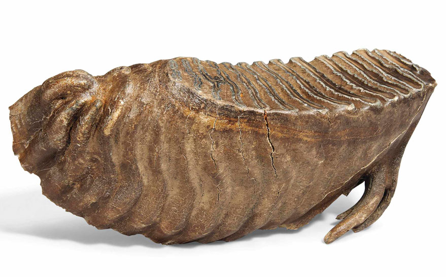
Wooly mammoth tooth offered for sale at Christie’s in 2015, which fetched £2750 (Credit: Christie’s on-line archives)

The mammoth molars have been dated at 0.68, 1.0 and 1.2 Ma (conservative estimates), far older than a horse dated between 560 and 780 ka that yielded DNA several years back. The sheer mass of the teeth and the fact that they had been preserved in frozen soil shielded genetic material from complete breakdown, but it was nonetheless heavily degraded to fragments no more than 50 base pairs long. This presented a major challenge to the team of palaeogeneticists’ reconstruction of the three mammoths’ genomes. Comparing the genomes with those of far younger woolly mammoths and their closest living relatives, Indian elephants, reveals that the ancient beasts were cold-adapted and probably had woolly coats. Two of the genomes suggest direct ancestry to both later woolly mammoths, whereas the third – the oldest – can  be linked to the enormous Columbian mammoth (M. columbi) that lived on mid-American grasslands during the Late Pleistocene. During glacial maxima when sea levels were ~100 m lower than at present Siberian faunas could easily have migrated into and colonised the Americas, using the Beringia land bridge across the Bering Strait. An early migration by the oldest Siberian mammoth could have given rise to the Columbian mammoth, later crossings to the American woollies. In fact it seems that genetic strands from the two younger Siberian mammoths also entered the DNA of M. columbi at some stage in its evolution.

Interesting as these revelations are about Arctic ice-age megafaunas, finding human remains that predate a few 10’s of ka in permafrost is unlikely. Modern humans and  Neanderthals are known to have migrated through Arctic Siberia, and perhaps Denisovans did too. Some individuals may have been unfortunate enough to have fallen into boggy ground that froze to form permafrost. However, there is no evidence for older human species having moved north of about 40°N since the first Africans entered 1.8 Ma ago. In any case, without the protection of massive bones, human DNA would probably have degraded more quickly than did that of these old mammoths.

See also: Roca, A.L. 2021. Million-year-old DNA provides a glimpse of mammoth evolution. Nature, v. 591, p. 208-209; DOI: 10.1038/d41586-021-00348-w; Black, R. 2021. Oldest DNA sequenced yet comes from million-year-old mammoths (Smithsonian Magazine, 17 February, 2021)

News from the Chicxulub drilling project

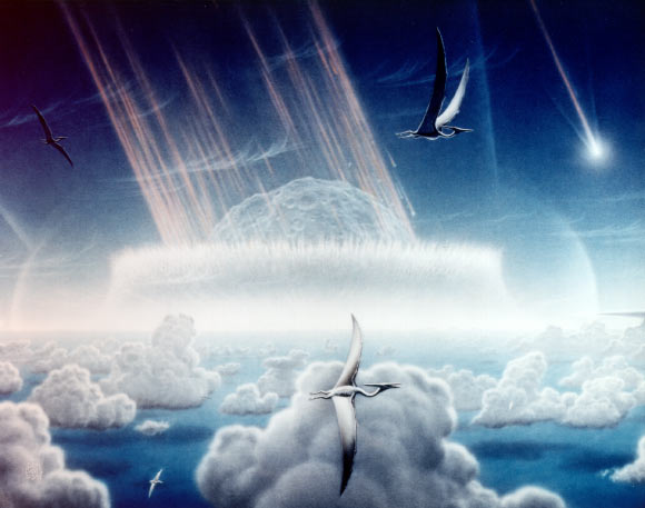
Artist’s impression of an asteroid slamming into the shallow sea off the present Yucatán Peninsula about 65 Ma ago (Credit: Donald E. Davis of NASA)

Aimed at resolving the impact versus volcanism debate about the causes of the K-Pg mass extinction, the International Ocean Discovery Program (IODP) and International Continental Scientific Drilling Program (ICDP) began drilling into the focus of the Chicxulub impact structure off the Yucatán Peninsula, Mexico in 2016. The project recovered 830 m of rock core, of which  about 140 cm contained the boundary between tsunami deposits and the post-impact marine limestones of Danian Age (basal Palaeogene); as close as one can get to the moment when the asteroid hit the sea floor. That an impact close to the start of the Danian had taken place was first discovered from abnormally high concentrations of the platinum-group metal iridium (Ir), shocked mineral grains and glass spherules, among other anomalous materials, in 350 marine and terrestrial sections across the globe. If the Chicxulub crater contained similar features to these ‘smoking guns’ then the link might seem to be done and dusted. A report on the crucial few centimetres from the Chicxulub drill core shows this to be the case (Goderis, S. and 32 others 2021. Globally distributed iridium layer preserved within the Chicxulub impact structure. Science Advances, v. 9, article eabe3647; DOI: 10.1126/sciadv.abe3647).

Yet the boundary layer at Chicxulub could not have been emplaced at the instant of impact. The gigantic power involved would have flung debris outwards, including seawater as well as the rocks that were once at considerable depth below the seabed. Much in the manner of a stone falling into a pond molten crust would have rebounded from the initial strike to form an axial peak and a ringed basin. Likewise huge tsunamis would have rolled away from the impact, then to return and fill the new basin, perhaps several times. Some of the ejected debris would have reached low orbit in the form of pulverised rock and asteroid to remain there for a while before completely falling back to Earth. The core includes about 130 m of once partly molten debris (suevite) above more-or-less intact granitic basement. Only the top 3.5 m show signs of having been deposited in water; fine-grained, well-sorted and laminated suevite containing clasts of once molten material and even late-Cretaceous foraminifera tests, formed probably by the refilling of the impact basin during the backflow of tusunamis. A mere 3 cm of silt and clay just below marine limestones has yielded the characteristic high Ir and nickel concentrations. This Ir-rich layer also contains the earliest Palaeocene foraminifera.

Grains in the Ir-rich layer were the last to settle, the main question being ‘How long after the impact took place did that happen?’ Being very fine they are estimated to have fallen-out from suspension and circulation in the atmosphere over a period of up to a few decades. Coarser material below them would have taken no longer than a few weeks to years. Yet these estimates are based mainly on Stokes’ law governing particles of different sizes falling through a viscous fluid. Taking an empirical view based on actual rates of clay sedimentation in the ocean (~5 mm per thousand years) the Ir-rich layer may have been deposited over 6000 years. That is hardly the ‘instant of the impact’. But the timing does say something interesting about the return of life to the seas; in geological terms it was swift, if the forams are anything to go by. Since the tsunamis swept onto and drained the surrounding land masses a great deal of nutrient would have ended up in the sea awaiting organisms at the bottom of the food chain. Biomarker chemicals and trace fossils in the Ir-rich layer suggest  thriving bacterial communities, with forams, crustacea and larval fish.

The authors conclude ‘The clear association of the Ir anomaly within the Chicxulub impact structure and the recorded biotic response confirms the direct relationship between the impact event and the K-Pg mass extinction’. Whether that is accepted by those geoscientists with their eyes on the Deccan Trap hypothesis is not so certain …

Indian groundwater shortage threatens food production

Farmers in India have been engaged in mass protests since September 2020. Their anger is directed at a series of laws introduced by the central government of Narendra Modi’s  Bharatiya Janata Party (BJP) that change farmers’ terms of trade. Agriculture in India also faces a future of reduced availability of groundwater on which farmers have become increasingly dependent, especially in the vast alluvial plains of the Ganges river system. The twin satellites of the Gravity Recovery  and Climate Experiment (GRACE), which chart changes in mass beneath the Earth’s surface, detected a major change in gravity over 3 million km2 of India’s largest area of agriculture in the northwestern Gangetic plains (Rodell, M. et al. 2009. Satellite-based estimates of groundwater depletion in India. Nature, v. 460, p.999-1002; DOI: 10.1038/nature08238). The data suggested a loss between 2002 and 2008 of around 109 cubic kilometres of water from the aquifers that support regional irrigation and the livelihoods of about 114 million people (see NASA summary). The loss of water and decline in well-water levels have continued since then.

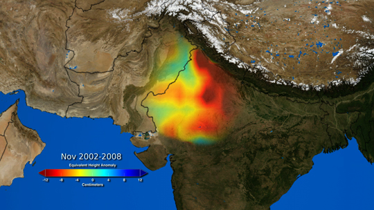
Colour-coded GRACE data  from 2002 to 2008 showing the estimated drawdown in water levels in wells in NW India and NE Pakistan during this period. Green to dark-red colours indicate from 0 to 12 metres of decline (credit: Trent Schindler and Matt Rodell, NASA)

A recent comprehensive survey (Jain, M. and 8 others 2021. Groundwater depletion will reduce cropping intensity in India. Science Advances, v. 9, article eabd2849; DOI: 10.1126/sciadv.abd2849) uses satellite image and census data to document the actual changes in winter crops (those most dependent on irrigation) over the period 2001 to 2012. It roughly measures the realities of the unsustainable extraction of groundwater indicated by GRACE from 2002 to 2008. The study projects an average reduction of 20% in winter cropping across the whole of India, with some of the worst-hit areas being likely to experience a 68% loss. The dominant supplies of irrigation water are from countless tube wells and systems of canals supplied by dams or rivers. India has witnessed impressive gains in food production in the last half century, thanks to rapid and continuing growth in the number of tube wells driven by individual farmers. The livelihoods of about 600 million people depend on agriculture. There is no prospect of substituting either form of irrigation to maintain current levels of production. If increased canal supply was used to replace well water and reduce groundwater depletion, cropping intensity would still decline, albeit at about half the projected rate; however, that doesn’t take into account unpredictable droughts in surface water accumulation and movement.

Faced with this situation, it is hardly surprising that farmers fear for their families future and react massively to state intervention in their marketing and crop storage strategies.

For a wider context to the Indian agricultural crisis see also: The ecological roots of India’s farming crisis (Deutche Welle, 1 February, 2021)