The late-Ordovician mass extinction: volcanic connections

The dominant feature of Phanerozoic stratigraphy is surely the way that many of the formally named major time boundaries in the Stratigraphic Column coincide with sudden shifts in the abundance and diversity of fossil organisms. That is hardly surprising since all the globally recognised boundaries between Eras, Periods and lesser divisions in relative time were, and remain, based on palaeontology. Two boundaries between Eras – the Palaeozoic-Mesozoic (Permian-Triassic) at 252 Ma and Mesozoic-Cenozoic (Cretaceous-Palaeogene) at 66 Ma – and a boundary between Periods – Triassic-Jurassic at 201 Ma – coincide with enormous declines in biological diversity. They are defined by mass extinctions involving the loss of up to 95 % of all species living immediately before the events. Two other extinction events that match up to such awesome statistics do not define commensurately important stratigraphic boundaries. The Frasnian Stage of the late-Devonian closed at 372 Ma with a prolonged series of extinctions (~20 Ma) that eliminated  at least 70% of all species that were alive before it happened. The last 10 Ma of the Ordovician period witnessed two extinction events that snuffed out about the same number of species. The Cambrian Period is marked by 3 separate events that in percentage terms look even more extreme than those at the end of the Ordovician, but there are a great many less genera known from Cambrian times than formed fossils during the Ordovician.

Untitled-1
Faunal extinctions during the Phanerozoic in relation to the Stratigraphic Column.

Empirical coincidences between the precise timing of several mass extinctions with that of large igneous events – mainly flood basalts – suggest a repeated volcanic connection with deterioration of conditions for life. That is the case for four of the Famous Five, the end-Ordovician die-off having been ascribed to other causes; global cooling that resulted in south-polar glaciation of the Gondwana supercontinent and/or an extra-solar gamma-ray burst (predicated on the preferential extinction of Ordovician near-surface, planktonic fauna such as some trilobite families). Neither explanation is entirely satisfactory, but new evidence has emerged that may support a volcanic trigger (Jones, D.S. et al. 2017. A volcanic trigger for the Late Ordovician mass extinction? Mercury data from south China and Laurentia. Geology, v. 45, p. 631-634; doi:10.1130/G38940.1). David Jones and his US-Japan colleagues base their hypothesis on several very strong mercury concentrations in thin sequences in the western US and southern China of late Ordovician marine sediments that precede, but do not exactly coincide with, extinction pulses. They ascribe these to large igneous events that had global effects, on the basis of similar Hg anomalies associated with extinction-related LIPs. Yet no such volcanic provinces have been recorded from that time-range of the Ordovician, although rift-related volcanism of roughly that age has been reported from Korea. That does not rule out the possibility as LIPs, such as the Ontong Java Plateau, are known from parts of the modern ocean floor that formed in the Mesozoic and Cenozoic. Ordovician ocean floor was subducted long ago.

The earlier Hg pulses coincide with evidence for late Ordovician glaciations over what is now Africa and eastern South America. The authors suggest that massive volcanism may then have increased the Earth’s albedo by blasting sulfates into the stratosphere. A similar effect may have resulted from chemical weathering of widely exposed flood basalts which draws down atmospheric CO2. The later pulses coincide with the end of Gondwanan glaciation, which may signify massive emanation of volcanic CO2 into the atmosphere and global warming. Despite being somewhat speculative, in the absence of evidence, a common link between the Big Five plus several other major extinctions and LIP volcanism would quieten their popular association with major asteroid and/or comet impacts currently being reinvigorated by drilling results from the K-Pg Chicxulub crater offshore of Mexico’s Yucatan Peninsula.

New dates for earliest human occupation of Australia

When modern humans first reached Australia has an importance beyond the starting date for the island continent’s archaeology and confirmation that their ancestors are the oldest known migrants from Africa. The first native Australians carried within their genome important information about the minimum date at which some non-Africans interbred with more archaic Neanderthal and Denisovan humans, traces of whose DNA are are present in that of living Australian aborigines. Most dating of when modern humans first reached different parts of the non-African world has relied on the radiocarbon method, which is suspect from beyond 40 to 45 ka as 14C produced earlier has decayed to levels that are now below the practical limit of detection and measurement. It is therefore no accident that the bulk of ‘first-arrival’ dates for Eurasia and Australasia are around 45 ka. In fact, any accurate age, however old, for the earliest skeletal remains only indicates the minimum date of arrival until other remains are discovered.

Reliable dating of earlier events in the Pleistocene relies on other methods, the most important for settings other than speleothem from caves being optically stimulated luminescence (OSL) applied to soil minerals that estimates their time of burial. Briefly, molecules of soil grains made of a mineral such as quartz are ‘charged-up’ with energy by radiation emitted by unstable isotopes in the soil. Exposure to light releases that stored energy in the form of luminescence. Measuring the amount of luminescence emitted by optically stimulated grains therefore gives a measure of the time since they were buried and ceased to be exposed to sunlight.

Madjedbebe rock shelter
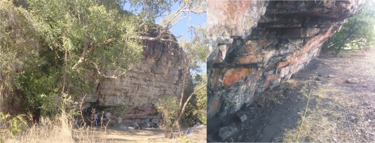
The Madjedbebe rock shelter in Arnhem Land, Northern Territories, Australia. (Credit: Chris Clarkson, University of Queensland)

A re-evaluation of the Madjedbebe site in the Northern Territory, widely accepted as having yielded Australia’s oldest artefacts in 1989, takes back human occupation more than 20 thousand years before previous estimates (Clarkson and 27 others 2017. Human occupation of northern Australia by 65, 000 years ago. Nature, v.  547, p. 306-310; doi:10.1038/nature22968). The soil profile in the Madjedbebe rock shelter turns out to be littered with artefacts – including hearths, tools and blocks of ochre and reflective mica pigments, plus remnants of plant foods – to a depth of ~2.5 m, with three particularly dense accumulations. Carbon-rich remains are also present throughout the profile which provided a means of accurate calibration and confirmation of OSL dates back as far as the radiocarbon method allows, giving confidence in the older OSL dates that extend to 65.0±5.7 ka in the earliest zone of dense artefact finds. Because the modern DNA of Australia’s first native people shows no sign of mixture with other modern humans, this places the timing of modern human interbreeding with archaic people before this time. The age also predates the range when the continent’s megafauna began to decline to eventual extinction, which supports the view that it was anthropogenic.

See also: Marean, C.W. 2017. Early signs of human presence in Australia. Nature, v.  547, p. 285-287; doi:10.1038/547285a.

Gas hydrates: a warning from the past

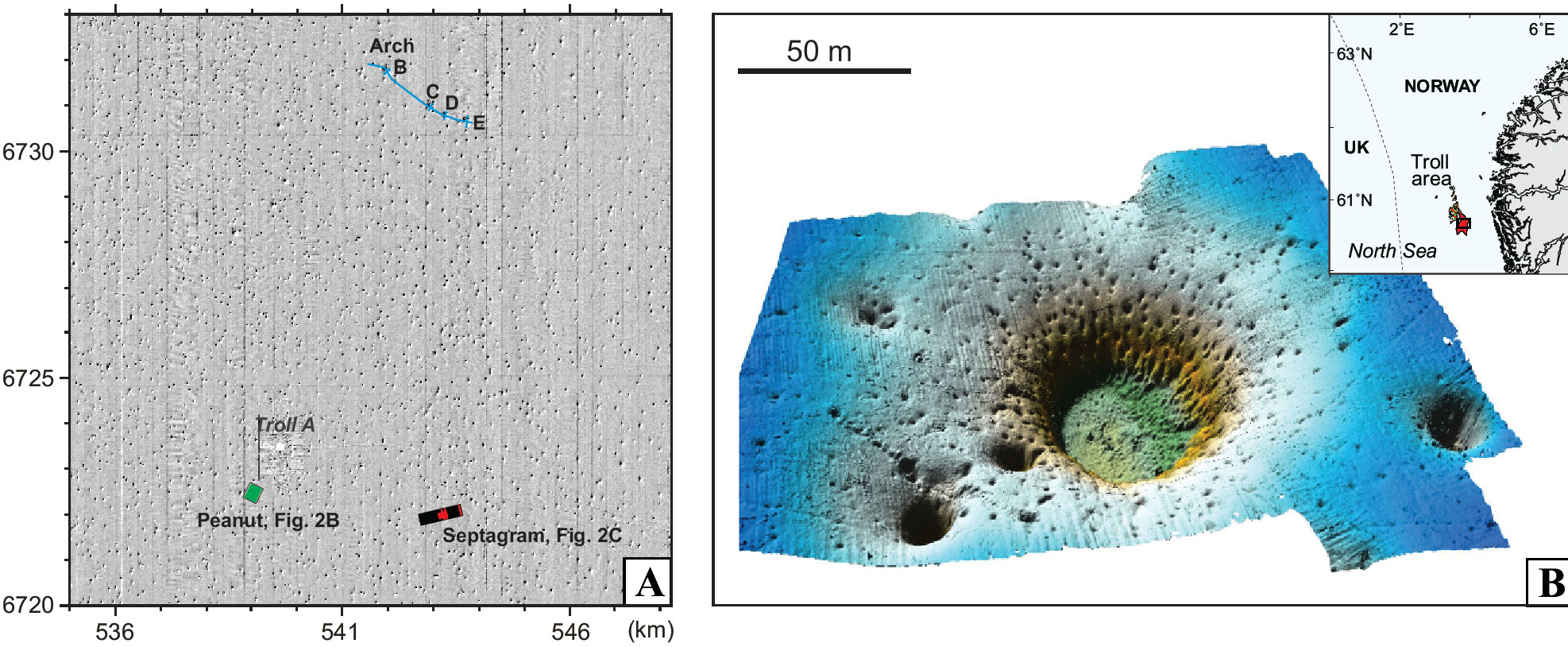
Detailed acoustic imaging above the Troll gas field in the northern North Sea off western Norway has revealed  tens of thousands of elliptical pits on the seabed. At around 10 to 20 per square kilometre over an area of about 15,000 km2 there are probably between 150 to 300 thousand of them. They range between 10 to 100 m across and are about 6 m deep on average, although some are as deep as 20 m. They are pretty much randomly distributed but show alignment roughly parallel to regional N-S sea-floor currents. Many of the world’s continental shelves display such pockmark fields, but the Troll example is among the most extensive. Almost certainly the pockmarks formed by seepage of gas or water to the surface. However, detailed observations suggest they are inactive structures with no sign of bubbles or fluid seepage. Yet the pits cut though glacial diamictites deposited by the most recent Norwegian Channel Ice Stream through which icebergs once ploughed and which is overlain by thin Holocene marine sediments. One possibility is that they record gas loss from the Troll field, another being destabilisation of shallow gas hydrate deposits.

Troll pockmarks
Parts of the Troll pockmark field off Norway. A: density of pockmarks in an area of 169 square km. B: details of a cluster of pockmarks. (Credit: Adriano Mazzini, Centre for Earth Evolution and Dynamics (CEED) University of Oslo)

Norwegian geoscientists have studied part of the field in considerable detail, analysing carbonate-rich blocks and foraminifera in the pits (Mazzini, A. and 8 others 2017. A climatic trigger for the giant Troll pockmark field in the northern North Sea. Earth and Planetary Science Letters, v. 464, p. 24-34; http://dx.doi.org/10.1016/j.epsl.2017.02.014). The carbonates show very negative δ13C values that suggest the carbon in them came from methane, which could indicate either of the two possible means of formation. However, U-Th dating of the carbonates and radiocarbon ages of forams in the marine sediment infill suggest that they formed at around 10 ka ago; 1500 years after the end of the Younger Dryas cold episode and the beginning of the Holocene interglacial. Most likely they represent destabilisation of a once-extensive, shallow layer of methane hydrates in the underlying sediments, conditions during the Younger Dryas having been well within the stability field of gas hydrates. Sporadic leaks from the deeper Troll gas field hosted by Jurassic sandstones is unlikely to have created such a uniform distribution of gas-release pockmarks. Adriano Mazzini and colleagues conclude that rapid early Holocene warming led to sea-floor temperatures and pressures outside the stability field of gas hydrates. There are few signs that hydrates linger in the area, explaining the present inactivity of the pockmarks – all the methane and CO2 escaped before 10 ka.

Gas hydrates are thought to be present beneath shallow seas today, wherever sea-floor sediments have a significant organic carbon content and within the pressure-temperature window of stability of these strange ice-like materials. Mazzini et al.’s analysis of the Troll pockmark field clearly has profound implications for the possible behaviour of gas hydrates at a time of global climatic warming. As well as their destabilisation adding to methane release from onshore peat deposits currently locked by permafrost and a surge in global warming, there is an even more catastrophic possibility. The whole of the seaboard of the southern North Sea was swept by a huge tsunami about 8000 years ago, which possibly wiped out Mesolithic human occupancy of lowland Britain, the former land mass of Doggerland, and the ‘Low Countries’ of western Europe. This was created by a massive submarine landslide – the Storegga Slide just to the north of the Troll field – which may have been triggered by destabilisation of submarine gas hydrates during early Holocene warming of the oceans.

Steam-bath Earth

The Earth’s mantle probably contained a significant amount of water from the start. Its earliest history was one of intense bombardment, including the impact that formed the Moon. Together with the conversion of gravitational potential energy to heat while the core was settling out from the mantle, impacts would have kept its overall temperature high enough to prevent water vapour from condensing on the surface until such heat input ceased and heat loss by radiation allowed the surface rapidly to cool. The atmosphere would have been rich in water vapour. Evidence from zircons that are the earliest tangible materials yet recovered hint at the formation of Zr-rich magmas – probably granitic in the broad sense – about 100 Ma after the Moon-forming event (see EPN July 2001: Zircons’ window on the Hadean). Yet no trace of substantial granitic rocks that old have ever been found.

Don Baker and Kassandra Sofonio of McGill University in Montreal, Canada have considered processes other than partial melting or fractional crystallisation that may have been possible during the earliest Hadean. In particular they have looked at one thought once to be a contender in the genesis of granite and latterly sidelined (Baker, D.R. & Sofonio, K. 2017. A metasomatic mechanism for the formation of Earth’s earliest evolved crust. Earth and Planetary Science Letters, v. 463, p. 48-55; http://dx.doi.org/10.1016/j.epsl.2017.01.022 ). They heated powdered artificial samples that chemically resembled the Earth’s original silicate mantle in sealed double capsules – an inner part containing the silicate powder and an outer one containing water. The capsules were held at around 727°C for a time and then quenched. The outer part of each capsule was found to be a glass of roughly granite composition. The experimental design ensured that superheated water diffused across the inner-outer capsule wall. So the ‘granite’ must have formed by a metasomatic process – essentially preferential solution of its component elements in supercritical water – the experimental temperature being insufficient to partially melt the ultramafic charge in the inner capsule.

Baker and Sofonio conclude that degassing of this metasomatic fluid – silicate-rich ‘steam’ – may have produced substantial masses of sialic crust on the Earth’s surface. Removal of material produced in such a manner would also have extracted trace elements with an affinity for granite from the early mantle – so-called incompatible elements. The subsequent recycling of such granitic blobs back into the mantle may explain geochemical signs in >500 Ma younger Archaean crust – produced by ‘normal’ igneous processes – of incompatible-element enriched reservoirs in the Early mantle.