Over the last few decades improved analytical techniques have made it possible to analyse tiny mineral grains for a variety of trace elements and several isotopes. Zircons obtained directly from crushed granitic igneous rocks vary in chemistry according to the magmatic processes that generated them and their tectonic context. Elevated ratios between uranium and niobium (U/Nb) and scandium and ytterbium (Sc/Yb) are characteristic of zircons in intermediate granites. These contain 52 to 63 % SiO2 – between mafic and felsic magmas – which formed by melting of hydrated mafic crust in settings akin to modern continental arcs; i.e. in subduction zones. But such partial melting can also take place where the base of continental crust delaminates and ‘drips’ into the mantle. That process is part of what is known as stagnant lid tectonics, believed by many to have been important in the Palaeoarchaean and Hadean. Such a process would have involved nearly anhydrous conditions and thus different geochemical partitioning of elements in the magmas and minerals that crystallised from them. Exposures of crystalline continental crust become increasingly rare further back in geological time, and there are none older than 4.0 Ga – i.e. of Hadean age – with a granitic component. Consequently studying the generation of continental crust in the Hadean and the early Archaean is almost entirely dependent on ancient zircons that found their way into much younger sedimentary rocks. The most famous of these occur as detrital grains in the 3.6 Ga Jack Hills conglomerate of Western Australia. Others have been extracted from similar ~3.3 Ga sedimentary rocks in the Barberton Greenstone Belt of South Africa and Eswatini.
Cartoon of possible Hadean stagnant lid tectonics, dominated by mantle plumes. (Credit: Bédard, J.H. 2018, Fig 3B, DOI: 10.1016/j.gsf.2017.01.005)
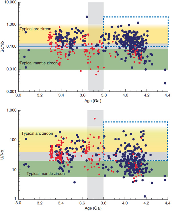
John Valley of the University of Wisconsin-Madison, USA, and co-workers from the US, Germany, Australia and France have worked on a large number of zircons newly extracted from Jack Hills. They have radiometrically dated them, and analysed Nb, Sc, U and Yb trace elements and hafnium (Hf) and oxygen isotopes Together with data from earlier studies, including Barberton zircons, they have teased out some remarkable insights into ‘continent-forming’ magmatism as far back in time as 4.4 billion years ago (Valley, J.W. and 11 others 2026. Contemporaneous mobile- and stagnant-lid tectonics on the Hadean Earth. Nature, Open access; DOI: 10.1038/s41586-025-10066-2). More than 70% of the >4.0 Ga Jack Hills zircons have elevated U/Nb and Sc/Yb ratios, which suggest that they formed in a setting akin to continental-arc subduction (CAS) zones, to produce now-vanished Hadean continental crust. The remainder seem to represent processes at mid-ocean ridge (MOR) and oceanic island (OI) settings. In contrast, the bulk of Barberton zircons of Hadean age show OI affinities, with only around 22% showing Nb–Sc–U–Yb signatures of probable CAS origins. From about 4.4 to 3.8 Ga two distinct forms of continental crust generation seem to have operated on Earth. In the erosional source region for the Barberton zircons their host granites seem to have formed during the Hadean and Eoarchaean by remelting of foundered lower crust, i.e. probably in a stagnant-lid-like tectonic setting. But at around 3.6 Ga they ‘flip’ to a subduction-like setting. The zircons yielded by Jack Hills conglomerates suggest substantially different conditions: alternating CAS and OI settings during the Hadean and a fall-off in crust generation during the Eoarchaean (4.0 to 3.8 Ga).
Plots of Sc/Yb and U/Nb against ages of zircons (vertical scale logarithmic). Black points are from Jack Hills, red from Barberton. The yellow field represents zircons formed in subduction zones; green suggests stagnant lid tectonics; grey the overlap between the two settings. Credit: Valley et al. Fig 3 a and b.
The mixed Hadean zircon signatures from Jack Hills possibly indicate that they were derived by erosion and transport from several distinct terranes that had been generated by two different processes: some kind of upper crustal recycling and stagnant lid tectonics. Meanwhile, that part of the Hadean Earth represented by the Barberton zircons may have been a long-lived regime of stagnant lid tectonics, replaced by dominant subduction at the end of the Eoarchaean. Yet the data suggest that into the Palaeoarchaean (3.6 to 3.2 Ga) and perhaps later, lid tectonics continued to operate somewhere, but at no time after 4.4 Ga was the Earth entirely subject to lid tectonics. Likewise, the authors insist that subduction was not of the plate-tectonic style, referring to some form of recycling of hydrated upper crustal mafic and ultramafic rocks into the mantle to undergo partial melting. Plate tectonics as we know it probably developed later in the Archaean. The early Earth had much higher heat flow than in later times, and thus the lithosphere was more ductile rather than brittle. The essence of modern tectonics is a series of rigid plates that extend down to the asthenosphere. When they deform it is largely through brittle failure of the entire lithosphere.
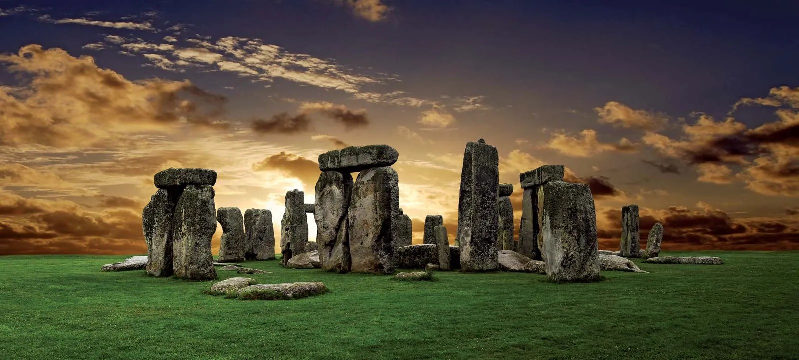
The great megalithic structure is the centrepiece of a vast ritual landscape on a 780 km2 plateau known as Salisbury Plain, underpinned by Cretaceous limestone: the largest remaining area of calcareous grassland in northwest Europe. The earliest sign that the Plain was used for ritual purposes dates to ten thousand years ago (8,000 BCE), when Mesolithic hunter gatherers erected large wooden posts to define by an E-W line the Sun’s rise and setting at the equinoxes. The area seems to have been continuously populated until 4,000 BCE when the first Neolithic farmers settled the Plain and began building burial mounds (barrows) to celebrate notable individuals and families.
The Stonehenge monument began as a circular cemetery around 3,100 BCE. Its development to the astonishing structure that remains largely intact today occupied the Neolithic populace and succeeding Bronze Age immigrants for the next 1,600 years. This involved setting up and then repeatedly shuffling around several kinds of boulders or megaliths. The first, around 2,600 BCE, were 2 to 3 tonne blocks mainly of igneous rock (the ‘bluestones’), now known to have originated from outcrops of Ordovician volcanics in Pembrokeshire about 230 km to the west. Next to arrive was a 6 tonne grey-green sandstone slab, now lying flat (hence its being named the ‘Altar’ Stone) beneath a fallen, far bigger megalith,. Once thought to be of Welsh provenance – in the Brecon Beacons 150 km to the west – the Altar Stone is now beyond a shadow of doubt to have come from Devonian strata in northern Scotland, possibly Orkney. The final erection of 30 truly enormous ‘sarsens’ to create Stonehenge’s signature circle and inner ‘horseshoe’ of vertical slabs capped by lintels took place between 2,600 to2 400 BCE. Weighing up to 50 tonnes, the sarsens are locally derived from remnants of Lower Eocene (~55 Ma) sands cemented by chemically precipitated silica (SiO2) that once covered much of southern England.
After 1,600 BCE, serious fiddling with the various stones, the bluestones in particular, ceased. The monument may have remained in some form of use during the Iron Age: it could hardly have been ignored. The first record of antiquarian interest is from the late 17th century and continued sporadically until systematic excavation of archaeological features on the Plain got underway during the 19th century and continues to the present.
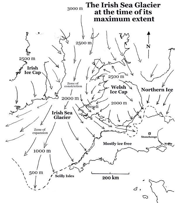
Much recent literature has concentrated on what Stonehenge was for and how it was built, leading to a rich eclecticism and a little experimentation. But given the size of its stones and the obviously exotic nature of some of them, there have been disputes between those who consider them to have been brought by natural means and those who suggest collective human endeavour. The latter would have involved vast amounts of labour, shifting the bluestones over 250 km, entire community muscle power to drag the locally occurring sarsens about 25 km from their probable source, and a journey of at least 700 km to get the Altar Stone in place. Since none of the stones could conceivably have been moved by river flow, the only natural alternative for their transport is by glacial action.
Such an ice-transport theory rests on at least one of the several known advances of Pleistocene ice sheets having reached as far south as Salisbury Plain and deposited upon it glacial till that contains material from NE Scotland and South Wales. The most obvious indicators of glacial transport are large erratic boulders strewn far from their source down a previous ice stream that their distribution helps to reconstruct. In Northern Britain a great many megaliths that people erected long ago are glacial erratics of one kind or another. Of course, glacial tills contain grains of all sizes ripped and ground from the course of glacial flow. No so obvious, but equally capable of revealing transportation paths. After ice sheets melt, the till that they dump is eroded so that exotic rock and mineral grains enter drainage systems, some to remain in stream sediments. Two geologists based at Curtin University in Perth, Western Australia collected river sands from four active drainage systems on Salisbury Plain to test the glacial-transport hypothesis for the Stonehenge megaliths (Clarke, A.J.I. & Kirkland, C.L. 2026. Detrital zircon–apatite fingerprinting challenges glacial transport of Stonehenge’s megaliths. Communications Earth & Environment, v. 7, article 54; DOI: 10.1038/s43247-025-03105-3).
Using standard mineral-separation techniques – removal of low-density minerals (mainly quartz and feldspar) and those that are magnetic – Anthony Clarke and Christopher Kirkland mounted and polished samples of the remaining high-density grains embedded in resin. Using automated X-ray spectroscopy they identified grains of two minerals, zircon and apatite, that can be dated using uranium and lead isotopes. Zircons are virtually absent from the underlying Chalk although phosphorus-rich horizons in that rock sometimes contain apatite, a complex calcium phosphate. Both minerals are commonly found in igneous and metamorphic rocks and, being chemically resistant and hard, are often present in sediments derived by erosion of such parent rocks. The authors analysed U-Pb isotopes using laser ablation plasma mass spectrometry of suitable grains of each mineral. The U-Pb data from 250 apatite grains revealed a dominant age peak at 60 Ma, roughly the base of the once overlying Palaeogene sediments. Far fewer grains hint at older ages (175, 215, 300 and 625 Ma) in the Mesozoic, Palaeozoic and Neoproterozoic. The 550 analysed zircons span an age range from the Silurian to Palaeoproterozoic (432 to 1870 Ma), with a few outliers as young as 285 Ma and as old as 3396 Ma.
These data seem to suggest that they can support virtually any glacial transport hypothesis, including that of the Altar Stone, let alone the Stonehenge bluestones. However, that would be to misunderstand the complexity of sediment transport in relation to their original provenance. Erosion from a bedrock source leads to transport and deposition in sedimentary rock. Later uplift and erosion of that secondary host rock is followed by later sediment transport to another rock repository and so on and so forth through the entire geological history of Britain, across its jumble of many tectonic terranes and the effects of numerous orogenic episodes! The Salisbury Plain chalk lands were covered by Palaeogene sedimentary rocks of the London Basin. And, lo and behold, one of those younger sediments, the Thanet Formation sandstones, tell much the same U-Pb story as do the modern river sediments of Salisbury! Those Palaeocene sands elsewhere directly overlie the Chalk and, in some localities on Salisbury Plain, still do today in the form of the chemically cemented sarsens. About 50 Ma ago (early Eocene) the Palaeocene rocks and those beneath were broadly buckled by the outermost ripples of the Alpine orogeny. Once eroded from above the Plain they would certainly have delivered that signature to the mercy of subsequent back and forth river transport. And indeed the sarsens, hard to miss in that landscape, perhaps still do so. Yet no one has thought to examine their content of heavy-mineral grains.
It does seem to me that the authors, perhaps inadvertently, walked into a sedimentological minefield in a vain attempt to put the lid on the fractious debate about human- versus glacial-transport of the Stonehenge megaliths. It is not their data that fling down a ‘challenge’ to the latter hypothesis (see their Conclusions), but the widely accepted absence of even the tiniest nugget of bluestone or Devonian sandstone on the vast and heavily excavated ritual landscape of Salisbury Plain, or indeed in the gravels of the streams that currently drain the Plain. But this where the plot thickens. A recent paper by one of the proponents of the glacial hypothesis (John, B.S. 2024. A bluestone boulder at Stonehenge: implications for the glacial transport theory. E&G Quaternary Science Journal v. 73, p. 117-134;DOI: 10.5194/egqsj-73-117-2024) describes a small piece of bluestone (22 × 15 × 10 cm) that was found during excavations at Stonehenge in 1924 and mysteriously ‘rescued’ by a Robert Newall and stored in his attic for almost 50 years, eventually examined by geologists and then returned to the attic. In 1976, two years before his death Newall passed it to the curator of Salisbury Museum ‘for safe keeping’. Brian John claims that its shape and surface texture suggests glacial transport. It also has several percussion scars suggesting that it had been worked, perhaps by someone hoping to make a stone tool. Unsurprisingly, Johns succeeded in provoking a storm of criticism from archaeologists largely of the human-transport wing of the controversy. And then there is the Mumbles Erratic, found at the eponymous Mumbles headland to the west of Swansea Bay. It too looks like a ‘bluestone’, but is it an erratic or from a Neolithic ship wreck carrying bluestones from Pembrokeshire?
Maximum extent of glaciation in SW Britain during the Anglian Stage 478 to 424 ka ago (Credit: Wikipedia Commons)
A great deal of work by British glaciologists has established the flow patterns and extent of major ice sheets, but only for four onshore, even though there is offshore evidence for repeated glaciation back as far as 2.5 Ma ago. The most extensive of these was the Anglian Stage between 478 and 424 ka ago. The figure above shows that the Irish Sea Glacier did not reach the Stonehenge area, but it did cross Pembrokeshire to reach Somerset on the eastern side of the Bristol Channel. Bluestone erratics may have been much more easily available than blocks hewn at their source in SW Wales, an hypothesis that is currently in vogue. Nope, the quest is not over …
Detrital zircon grains extracted from sandstones deposited ~3 billion year (Ga) ago in Western Australia yield the ages at which these grains crystallised. The oldest formed at about 4.4 Ga; only 150 Ma after the origin of the Earth (4.55 Ga). Various lines of evidence suggest that they originally crystallized from magmas with roughly andesitic compositions, which some geochemists suggest to have formed the first continental crust (see:Zircons and early continents no longer to be sneezed at; February 2006). So far, no actual rocks of that age and composition have come to light. The oldest of these zircon grains also contain anomalously high levels of 18O, a sign that water played a role in the formation of these silicic magmas. Modern andesitic magmas – ultimately the source of most continental crust – typically form above steeply-dipping subduction zones where fluids expelled from descending oceanic crust encourage partial melting of the overriding lithospheric mantle. Higher radiogenic heat production in the Hadean and the early Archaean would probably have ensured that the increased density of later oceanic lithosphere needed for steep subduction could not have been achieved. If subduction occurred at all, it would have been at a shallow angle and unable to exert the slab-pull force that perpetuated plate tectonics in later times (see: Formation of continents without subduction, March, 2017).
Landsat image mosaic of the Palaeoarchaean granite-greenstone terrain of the Pilbara Craton, Western Australia. Granite bodies show as pale blobs, the volcanic and sedimentary greenstone belts in shades of grey.
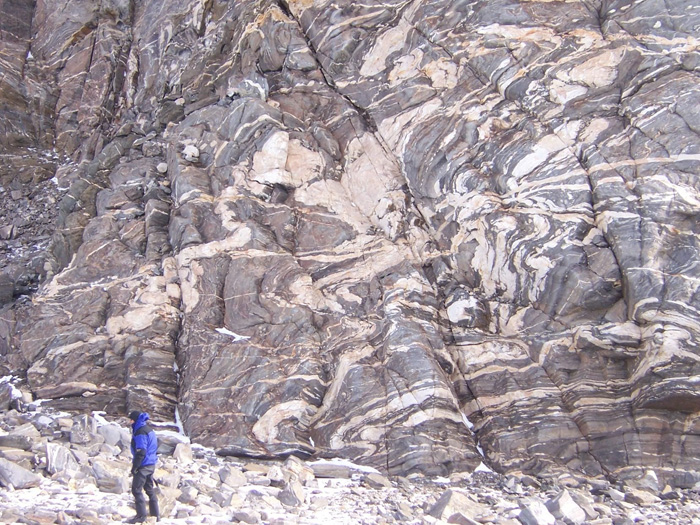
Geoscientists have been trying to resolve this paradox for quite a while. Now a group from Australia, Germany and Austria have made what seems to be an important advance (Hartnady, M. I. H and 8 others 2025. Incipient continent formation by shallow melting of an altered mafic protocrust. Nature Communications, v. 16, article 4557; DOI: 10.1038/s41467-025-59075-9). It emerged from their geochemical studies of rocks in the Pilbara Craton of Western Australia that are about a billion years younger than the aforementioned ancient zircon grains. These are high-grade Palaeoarchaean metamorphic rocks known as migmatites that lie beneath lower-grade ‘granite-greenstone’ terrains that dominate the Craton, which Proterozoic deformation has forced to the surface. Their bulk composition is that of basalt which has been converted to amphibolite by high temperature, low pressure metamorphism (680 to 730°C at a depth of about 30 km). These metabasic rocks are laced with irregular streaks and patches of pale coloured rock made up mainly of sodium-rich feldspar and quartz, some of which cut across the foliation of the amphibolites. The authors interpret these as products of partial melting during metamorphism, and they show signs of having crystallised from a water-rich magma; i.e. their parental basaltic crust had been hydrothermally altered, probably by seawater soon after it formed. The composition of the melt rocks is that of trondhjemite, one of the most common types of granite found in Archaean continental crust. Interestingly, small amounts of trondhjemite are found in modern oceanic crust and ophiolites.
A typical migmatite from Antarctica showing dark amphibolites laced with quartzofeldspathic products of partial melting. Credit: Lunar and Planetary Laboratory, University of Arizona
The authors radiometrically dated zircon and titanite (CaTiSiO₅) – otherwise known as sphene – in the trondhjemites, to give an age of 3565 Ma. The metamorphism and partial melting took place around 30 Ma before the overlying granite-greenstone assemblages formed. They regard the amphibolites as the Palaeoarchaean equivalent of basaltic oceanic crust. Under the higher heat production of the time such primary crust would probably have approached the thickness of that at modern oceanic plateaux, such as Iceland and Ontong-Java, that formed above large mantle plumes. Michael Hartnady and colleagues surmise that this intracrustal partial melting formed a nucleus on which the Pilbara granite-greenstone terrain formed as the oldest substantial component of the Australian continent. The same nucleation may have occurred during the formation of similar early Archaean terrains that form the cores of most cratons that occur in all modern continents.
False-colour electron microscope image of a shocked grain of zircon recovered from the Stac Fada Member. The red and pink material is a high-pressure polymorph of zircon, arranged in shock lamellae. Zircon is rendered in cyan, some of which is in granulated form. Credit: Kirkland et al. 2025, Fig 2C
Judging by its content of shards and spherules made of murky green glass, one of the lowest units in the Torridonian continental sediments of NW Scotland had long been regarded as simply red sandstone that contained volcanic debris. This Stac Fada Member was thus celebrated as the only sign of a volcanic contribution to a vast thickness (up to 2.5 km) of Neoproterozoic lake and fluviatile sediments. Current flow indicators suggested that the Torridonian was laid down by large alluvial fans derived by erosion of much older crystalline basement far to what is today the west. That is, the Archaean core of the ancient continent of Laurentia, now the other side of the North Atlantic. In 2002 more sophisticated sedimentological and geochemical analysis of the Stac Fada Member revealed a surprise: it contains anomalously elevated platinum-group elements, quartz grains that show signs of shock and otherworldly chromium isotope concentrations. The 10 m thick bed is made from ejecta, perhaps from a nearby impact crater to the WNW concluded from brittle fractures that may have been produced by the impact. Some idea of its age was suggested by Ar-Ar dating of feldspar crystals (~1200 Ma) believed to have formed authigenically in the hot debris. Being the only decent impactite known in Britain, it continues to attract attention.
A group of geoscientists from Western Australia, NASA and the UK, independent of the original discoverers, have now added new insights ( Kirkland, C.L. and 12 others 2025. A one-billion-year old Scottish meteorite impact. Geology, v. 53, early online publication; DOI: 10.1130/G53121.1). They dated shocked zircon grains using U-Pb analyses at 990 ± 22 Ma; some 200 Ma younger than the previously dated, authigenic feldspars. Detrital feldspar grains in the Stac Fada Member yield Rb-Sr radiometric ages of 1735 and 1675, that are compatible with Palaeoproterozoic granites in the underlying Lewisian Gneiss Complex.
Photomicrograph of Bicellum brazieiri: scale bar = 10μm; arrows point to dark spots that may be cell nuclei (credit: Charles Wellman, Sheffield University)
In a separate publication (Kirkland, C.L et al 2025. 1 billion years ago, a meteorite struck Scotland and influenced life on Earth. The Conversation, 29 April 2025) three of the authors take things a little further, as their title suggests. In this Conversation piece they ponder, perhaps unwarily, on the spatial and temporal association of the indubitable impact with remarkably well-preserved spherical fossils found in Torridonian lake-bed sediments (Bicellum brasieri, reported in Earth-logs in May 2021), which are the earliest-known holozoan animal ancestors. The Torridonian phosphatic concretions in which these important fossils were found at a different locality are roughly 40 Ma younger than the Stac Fada impactite. The authors of the Conversation article appeal to the residual thermal effect of the impact as a possible driver for the appearance of these holozoan organisms. Whether a residual thermal anomaly would last long enough for them to evolve to this biological status would depend on the magnitude of the impact, of which we know nothing. Eukaryote fossils are known from at least 650 Ma older sedimentary rocks in northern China and perhaps as far back as 2.2 Ga in a soil that formed in the Palaeoproterozoic of South Africa. Both the Torridonian organism and impactite were found in a small area of fascinating geology that has been studied continuously in minute detail since Victorian times, and visited by most living British geologists during their undergraduate days. Ideas will change as curiosity draws geologists and palaeobiologists to less-well studied sites of Proterozoic antiquity, quite possibly in northern China.
A fully revised edition of Steve Drury’s book Stepping Stones: The Making of Our Home World can now be downloaded as a free eBook
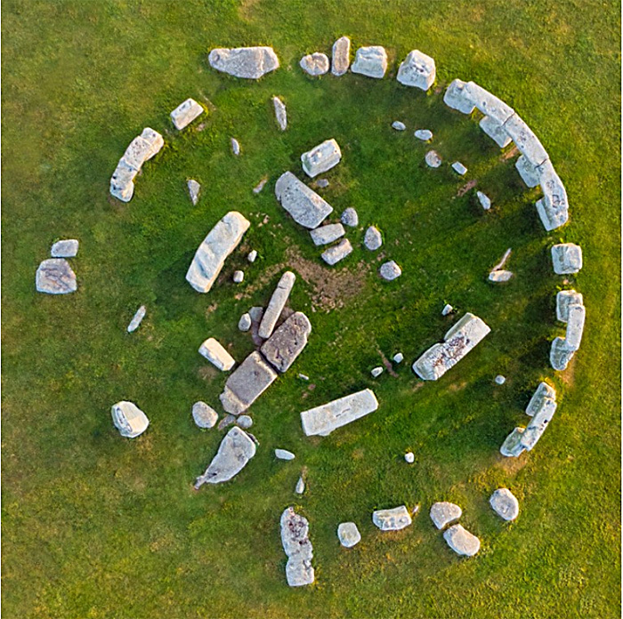
High resolution vertical aerial photograph of Stonehenge. (Credit: Gavin Hellier/robertharding/Getty)
During the later parts of the Neolithic the archipelago now known as the British Isles and Ireland was a landscape on which large stone buildings with ritual and astronomical uses were richly scattered. The early British agricultural societies also built innumerable monuments beneath which people of the time were buried, presumably so that they remained in popular memory as revered ancestors. Best known among these constructions is the circular Stonehenge complex of dressed megaliths set in the riot of earlier, contemporary and later human-crafted features of the Chalk downs known as Salisbury Plain. Stonehenge itself is now known to have been first constructed some five thousand years ago (~3000 BCE) as an enclosure surrounded by a circular ditch and bank, together with what seems to have been a circular wooden palisade. This was repeatedly modified during the following two millennia. Around 2600 BCE the wooden circle was replaced by one of stone pillars, each weighing about 2 t. These ‘bluestones’ are of mainly basaltic igneous origin unknown in the Stonehenge area itself. The iconic circle of huge, 4 m monoliths linked by 3 m lintel stones that enclose five even larger trilithons arranged in a horseshoe dates to the following two-centuries to 2400 BCE coinciding with the Early Bronze Age when newcomers from mainland Europe – perhaps as far away as the steppe of western Russia – began to replace or assimilate the local farming communities. This phase included several major modifications of the earlier bluestones.
It might seem that the penchant for circular monuments began with the Neolithic people of Salisbury Plain, and then spread far and wide across the archipelago in a variety of sizes. However, it seems that building of sophisticated monuments, including stone circles, began some two centuries earlier than in southern England in the Orkney Islands 750 km further north and, even more remote, in the Outer Hebrides of Scotland. A variety of archaeological and geochemical evidence, such as the isotopic composition of the bones of livestock brought to the vicinity of Stonehenge during its period of development and use, strongly suggests that people from far afield participated. Remarkably, a macehead made of gneiss from the Outer Hebrides turned up in an early Stonehenge cremation burial. Ideas can only have spread during the Neolithic through the spoken word. As it happens, the very stones themselves came from far afield. The earliest set into the circular structure, the much tinkered-with bluestones, were recognised to be exotic over a century ago. They match late Precambrian dolerites exposed in western Wales, first confirmed in the 1980s through detailed geochemical analyses by the late Richard Thorpe and his wife Olwen Williams-Thorpe of the Open University. Some suggested that they had been glacially transported to Salisbury Plain, despite complete lack of any geological evidence. Subsequently their exact source in the Preseli Hills was found, including a breakage in the quarry that exactly matched the base of one of the Stonehenge bluestones. They had been transported 230 km to the east by Neolithic people, using perhaps several means of transport. The gigantic monoliths, made of ‘sarsen’ – a form of silica-cemented sandy soil or silcrete – were sourced from some 25 km away where Salisbury Plain is still liberally scattered with them. Until recently, that seemed to be that as regards provenance, apart from a flat, 5 x 1 m slab of sandstone weighing about 6 t that two fallen trilithon pillars had partly hidden. At the very centre of the complex, this had been dubbed the ‘Altar Stone’, originally supposed to have been brought with the bluestones from west Wales.
The stones of Stonehenge colour-coded by lithology. The sandstone ‘Altar Stone’ lies beneath fallen blocks of a trilithon at the centre of the circle. (Credit: Clarke et al. 2024, Fig 1a)
A group of geologists from Australia and the UK, some of whom have long been engaged with Stonehenge, recently decided to apply sophisticated geochemistry at two fragments broken from the Altar Stone, presumably when the trilithons fell on it (Clarke, A. J. I. et al.2024. A Scottish provenance for the Altar Stone of Stonehenge. Nature v.632, p. 570–575; DOI: 10.1038/s41586-024-07652-1). In particular they examined various isotopes and trace-elements in sedimentary grains of zircon, apatite and rutile that weathering of igneous rocks had contributed to the sandstone, along with quartz, feldspar, micas and clay minerals. It turned out that the zircon grains had been derived from Mesoproterozoic and Archaean sources beneath the depositional site of the sediment (the basement). The apatite and rutile grains show clear signs of derivation from 460 Ma old (mid-Ordovician) granites. The basement beneath west Wales is by no stretch of the imagination a repository of any such geology. That of northern Scotland certainly does have such components, and it also has sedimentary rocks derived from such sources: the Devonian of Orkney and mainland Scotland surrounding the Moray Firth. Unlike the lithologically unique bluestones, the sandstone is from a thick and widespread sequence of terrestrial sediments colloquially known as the ‘Old Red Sandstone’. The ORS of NE Scotland was deposited mainly during the Devonian Period (419 to 369 Ma) as a cyclical sequence in a vast, intermontane lake basin. Much the same kinds of rock occur throughout the sequence, so it is unlikely that the actual site where the ‘Alter Stone’ was selected will ever be known.
To get the ‘Alter Stone’ (if indeed that is what it once was) to Stonehenge demanded transport from its source over a far more rugged route, three times longer than the journey that brought the bluestones from west Wales: at least 750 km. It would probably have been dragged overland. Many Neolithic experts believe that transport of such a large block by boat is highly unlikely; it could easily have been lost at sea and, perhaps more important, few would have seen it. An overland route, however arduous, would have drawn the attention of everyone en route, some of whom might have been given the honour of helping drag such a burden for part of the way. The procession would certainly have aroused great interest across the full extent of Britain. Its organisers must have known its destination and what it signified, and the task would have demanded fervent commitment. In many respects it would have been a project that deeply unified most of the population. That could explain why people from near and far visited the Stonehenge site, herding livestock for communal feasting on arrival. Evidence is now pointing to the construction and use of the ritual landscape of Salisbury Plain as an all-encompassing joint venture of most of Neolithic Britain’s population. It would come as no surprise if objects whose provenance is even further afield come to light. It remained in use and was repeatedly modified during the succeeding Bronze Age up to 1600 BCE. By that time, the genetic group whose idea it was had been assimilated, so that only traces of its DNA remain in modern British people. This seems to have resulted from waves of immigrants from Central Europe, the Yamnaya, who brought new technology and the use of metals and horses.
For a planet to produce life it needs various attributes. Exoplanet hunters tend to focus on the ‘Goldilocks’ Zone’ where solar heating is neither so extreme nor so little that liquid water is unstable on a planet’s surface. It also needs an atmosphere that retains water. Ultraviolet radiation emitted by a planet’s star dissociates water vapour to hydrogen and oxygen and the hydrogen escapes to space. The reason Earth has not lost water in this way is that little water vapour reaches the stratosphere because it is condensed or frozen out of the air as the lower atmosphere becomes cooler with altitude. Given moist conditions survivability to the extent that exists on Earth still needs another planetary parameter: the charged particles emitted as an interplanetary ‘wind ‘by stars must not reach the surface. If they did, their potential to break complex molecules would hinder life’s formation or wipe it out if it ventured onto land. A moving current of electrical charge, which is what a stellar ‘wind’ amounts to, can be deflected by a magnetic field. This is what happens on Earth, whose magnetic field is a good reason why our planet has supported life and its continual evolution since at least about 3.5 billion years ago.
Deflection of the solar ‘wind’ by Earth’s Earth’s magnetosphere. (credit: Wikipedia)
Direct proof of the existence of a geomagnetic field is the presence of aligned particles of magnetic minerals in rocks, for instance in a lava flow, caused by their acquiring magnetisation in a prevailing magnetic field once they cooled sufficiently. The earliest such remanent magnetism was found in igneous rocks from north-eastern South Africa dated at between 3.2 to 3.45 billion years. All older rocks do not show such a feature dating back to their formation because of thermal metamorphism that resets any remanent magnetism to match the geomagnetic field prevailing at the time of reheating. There are, however, materials that formed further back in time and are also known to resist thermal resetting of any alignments of magnetic inclusion. They are zircons (ZrSiO4), originally crystallised from igneous magmas, which may have locked in minute magnetic inclusions. Zircons are among the most change-resistant materials and they can also be dated with great precision, with the advantage that the U-Pb method used can distinguish between age of formation and that of any later heating. Famously, individual grains of zircon that had accumulated in an early Archaean conglomerate outcropping in the Jack Hills of Western Australia yielded ages going back from 3.2 to 4.4 billion years; far beyond the age of any tangible rock and close to the formation age of the Earth. Quite a target for palaeomagnetic investigations once a suitable technique had been developed.
Western Australia’s Jack Hills from Landsat (credit NASA Earth Observatory)
John Tarduno and colleagues from the Universities of Rochester and California USA and the Geological Survey of Canada report the magnetic properties of the Jack Hills zircons (Tarduno, J.A. et al. 2015. A Hadean to Paleoarchean geodynamo recorded by single zircon crystals. Science, v. 349, p. 521-524). All of the grains analysed record magnetisation spanning the period 3.2 to 4.2 billion years that indicate geomagnetic field strengths ranging from that found today at the Equator to about an eighth of the modern value. So from 4.2 Ga onwards geomagnetism probably deflected the solar wind: the early Earth was set for living processes from its earliest days. The discovery also supports the likelihood of functioning plate tectonics during the Hadean.
The oldest materials on the planet are tiny zircon grains that were washed into conglomerate in Western Australia about 2650 to 3050 Ma ago. It wasn’t the fact that the grains are zircons, which are among the most durable materials around, but the range of ages that they revealed when routinely analysed. U-Pb dating of detrital zircons is a well tested means of finding the provenance of sedimentary materials as an indicator of orogenic and igneous events that formed the crust from which they were eroded. In the original study of the Jack Hills zircons some showed ages that might reasonably have been expected from late sediments in an Archaean craton: around 3.5 billion years is about the maximum age for orogenic events there. What astonished all geoscientists was that a proportion of the grains gave ages of more than 4 billion years, some as old as 4.4 Ga: here was a window on the missing first half billion years of Earth history, the Hadean.
Subsequent work on yet more zircons confirmed the original age span but other kinds of analysis led to a variety of claims: that continental crust was around in abundance within 100 Ma of Earth having formed; geothermal heat =flow was not especially high; liquid water was available for geological processes, including the origin of life; plate tectonics may have started early…. The topic has cropped up several times in EPN sincethe issue of 1 January 2001. Quite a lot of the claims emerged from studies of other minerals enclosed by the ancient zircons, such as quartz and micas, and now they have been checked again by geochemists from Western Australia (Rasmussen, B. et al. 2011. Metamorphic replacement of mineral inclusions in detrital zircons from Jack Hills, Australia: Implications for the Hadean Earth. Geology, v. 39, p. 1143-1146). It turns out that the inclusions formed at temperatures well below those of magmas, between 350 to 490°C: more like those of metamorphism. Indeed, uranium-bearing rare-earth phosphate minerals, xenotime and monazite, also locked in the zircons not only turn out to be metamorphic in origin too (both are also formed magmatically) but date to between 2700 and 800 Ma.
While the Hadean zircon dates remain robust, a closer look at their inclusions shows that they did not remain geochemically closed systems thereafter. It was on the assumption of zircons being geological ‘time capsules’ that much of the excitement rested. Even using the presence of zircons from 4.4 Ga – they are most common in granites but do occur in mafic and intermediate igneous rocks – to suggest early ‘sialic’ continental crust is suspect. Despite having some tiny bits from Earth’s early days, it seems we are none the wiser.