Earthquakes and flooding in the Ganges Basin

Floods pose a huge threat to the large populations of West Bengal, India and the state of Bangladesh, particularly in the highly fertile fluvio-deltaic plains of the Ganges and Brahmaputra. The two river systems drain 2 million km2 of the Eastern Himalaya of annual monsoon rains and snow melt, the first flowing west to east and the latter from east to west at the apex of the low-lying Bengal Basin. The 400 million people subsisting in the 105 thousand km2 onshore basin make it the world’s most populous delta plain with one of the highest population densities, averaging 1,100 per square kilometre in 2019. The risk of catastrophic flooding is generally ascribed to unusually high monsoonal precipitation and snow melt, combined with storm surges from the Bay of Bengal that funnels tropical cyclones. But either can bring inundation. Another factor has recently been proposed as an addition to flood hazard: earthquakes near the basin (Chamberlain, E.L and 12 others 2024. Cascading hazards of a major Bengal basin earthquake and abrupt avulsion of the Ganges River. Nature Communications, v. 15, online article 4975; DOI: 10.1038/s41467-024-47786-4). It seems they can completely and suddenly change the flow networks in such a complex system of major channels.

Using remotely sensed data Elizabeth Chamberlain, currently at Wageningen University in the Netherlands, and colleagues from Bangladesh, the US, Germany and Austria have detected an immense abandoned channel in the Ganges River. They reckon that it resulted from a sudden change in the river’s course. Such avulsions in the sluggish lower parts of a river system are generally caused by the flow becoming elevated above the flood plain by levees. When they burst free the channel may be abandoned. This one is 1.0 to 1.7 km wide and may have been the main Ganges channel at the time of avulsion. The main channel now flows about 45 km north of the abandoned relic. The event must have been sudden and irreversible as the relic channel contains a much thinner layer of fine mud deposited by stagnant water than in other abandoned channels that became ox-bow lakes. That implies rapid uplift and complete drainage from the channel. Throughout the Bengal Basin the immense high-water discharge and heavy sediment load seems generally to have infilled most abandoned channels, so this one is an anomaly.

Sand dykes along fractures in river alluvium of the Bengal Basin. (Credit: Chamberlain et al. Figs 3c and 3d)

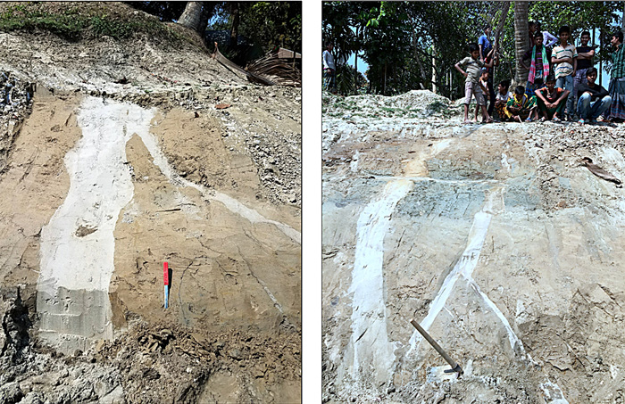
Fieldwork near the old channel reveals fracturing of earlier riverbed sediments some of which are filled by intrusions of sand in the form of dykes up to 40 cm wide. Sand dykes are produced by liquefaction of sandy alluvium by seismic waves to slurry that can be injected into fractures pulled apart by seismic movements. The channel is now about 3 m below the level of the floodplain, suggesting subsidence since the avulsion event. Optically stimulated luminescence dating of sediment grains from the uppermost channel sands yielded ages averaging around 2.5 ka, marking the time when the sudden event took place. The authors consider that it marked a major reorganisation of the Ganges River system, involving catastrophic flooding. The nearest seismically active area is about 180 to 300 km to the east and northeast. Seismic modelling suggests that for liquefaction and fracturing to have affected the area of the abandoned channel the earthquake must have been of magnitude 7.5–8.0, possibly in the subduction zone that roughly follows the Bangladesh-Myanmar border. It may have had similar, yet to be demonstrated, effects throughout the eastern Bengal Basin.

There are no historic records of more recent massive earthquake-induced flooding of the Bengal Basin. However, global warming and growing human intervention in the Ganges-Brahmaputra river systems, such as large-scale dredging and industrialisation could make such events more likely. Other basins close to seismically active fault systems, such as the Yangtze and Yellow River basins of China, also face such risks.

Many thanks to  Piso Mojado for giving me the tip about this paper

Aftershocks of ancient earthquakes

Any major earthquake is likely to be followed by aftershocks. Survivors of seismic devastation live in dread of them for weeks, even months. In reality the fault responsible for the initial event continues to move for longer than that. Commonly, aftershock activity dies down in magnitude and frequency over time, sometimes after a few weeks and in other cases much later to reach ‘normal background seismicity’ for the associated tectonic setting. Near a major plate boundary, such as the San Andreas Fault system in coastal California or the mid-Atlantic Ridge in Iceland, there is a continual risk of damaging seismic events, but the area around each major event becomes less risky a few tens of years afterwards. For instance, the Loma Prieta area on the San Andreas became quiescent sixteen years after the October 1989 Magnitude 6.9 earthquake that wrought havoc in San Francisco – and interrupted a Major League baseball match in the city. The December 1954, Magnitude 7.3 Dixie Valley earthquake in the active extensional zone of Nevada had a longer period of instability: 48 years. There is no fixed period for the aftermath, seismicity ‘stops when it stops’.

Earthquakes of greater than Magnitude 2.5 in eastern North America (see key to magnitudes at lower right). Those shown in blue date from 1568 to 1979, those in red between 1980 and 2016. (Credit: Chen & Liu, Fig 1)

Sometimes devastating earthquakes take place in what seem to be the least likely places: in tectonically ‘stable’ continental plate interiors. A Magnitude 7.9 earthquake in Sichuan Province, central China on 12 May 2008 left 86 thousand dead or missing, 374 thousand injured and 4.2 million homeless. It occurred in a region whose ancient fault systems had had little if any historic activity. One of the best studied records of seismic events in the middle of a continent is in the Mississippi River valley at the Missouri-Kentucky border, USA, near the town of New Madrid. This experienced three major earthquakes in 1811 and 1812 at Magnitudes estimated from 7.0 to 7.4. Seismicity there has continued ever since. Others that occurred long ago in the ‘stable’  North American continental crust were in South Carolina (1886) and southern Quebec, Canada (1663). They and the subsequent, lesser earthquakes that define clusters up to 250 km around them have been studied using spatial statistics (Chen, Y. & Liu, M. 2023. Long-Lived Aftershocks in the New Madrid seismic Zone and the Rest of Stable North America. Journal of Geophysics Research: Solid Earth, v. 128; DOI: 10.1029/2023JB026482). Yuxuan Chen and Mian Lui of Wuhan University, China and the University of Missouri, USA considered the dates of historic events, their estimated magnitudes and their proximity to other events in each cluster. The closer two events are the greater the chance that the later one is an aftershock of the first, although the relationship may also indicate a long-lived deformation process responsible for both. The authors suggest that this ‘nearest-neighbour’ approach may reveal that up to 65% of earthquakes in the New Madrid zone between 1980 and 2016 are aftershocks of the 1811-1812 major earthquake cluster, and a significant number of modern events in South Carolina could similarly relate to the 1886 Charleston earthquake. On the other hand, small modern earthquakes in Quebec are more likely to be part of the regional seismic background than to have any relationship to the large 17th century event.

Earthquakes are manifestations of deep-seated processes, most usually the build-up and release of strain in the lithosphere. If such processes persist they can result in long-lived earthquake swarms. So both delayed aftershocks and a high background of seismicity can contribute to the mapped clusters of historic events: a blend of relics of the past and modern deformation. They are yet to be detected in earthquake records associated with tectonic plate boundaries. A long history of movements within continents suggests that it is possible that long-delayed aftershocks may masquerade as foreshocks that presage greater events that are pending. Chen and Liu’s nearest-neighbour approach may therefore distinguish false alarms from real risk of major seismic motions.

See also: Some of today’s earthquakes may be aftershocks from quakes in the 1800s. Eureka|Alert, 13 November 2023

Music based on earthquake waves

Many readers will have heard the vibration signal of an earthquake, as recorded by a seismometer, and replayed through a speaker: listen to some examples here. They are eerily like the sounds of falling, multi-storey buildings. Scary, especially if you think of the horrors of the devastation in SE Turkiye and NE Syria caused by the 6 February 2023 magnitude 7.8 event on the East Anatolian Fault system

Since P-waves are very like sound waves, audibly converting the one to the other is relatively simple. However, earthquakes are rarely single events, each major one being preceded by foreshocks and followed by aftershocks, both recurring over weeks or months. Highly active areas are characterised by earthquake swarms that can go on continuously, as happens with sea-floor spreading at mid-ocean ridges. In the case of Yellowstone National Park there are continual quakes, but there the seismicity results from magma rising and falling above a superplume. Most of such swarm-quakes are diminutive, so playing the speeded-up signal through a loudspeaker just sounds like a low, tremulous hiss.

Domenico Vicinanza a physicist at the Anglia Ruskin University in Cambridge UK specialises in creating music from complex scientific data, including those from CERN’s Large Hadron Collider in Geneva, to help interpret them. He has recently turned his hand to the Yellowstone earthquake swarm, converting the amplitudes and frequencies of its real-time seismograph to notes in a musical score: listen to the results here. They are surprisingly soothing, perhaps in the manner of the song of the humpback whale used by some to help with their chronic insomnia.

See also:  Davis, N. Rock concert: Yellowstone seismic activity to be performed on live flute, The Guardian; 8 May 2023

Sun, sand and sangria on the Mediterranean Costas – and tsunamis?

You can easily spot a tourist returning from a few summer weeks on the coast of the western Mediterranean, especially during 2022’s record-breaking heat wave and wildfires: sunburnt and with a smoky aroma that expensive après-sun lotion can’t mask. Judging from the seismic records, they may have felt the odd minor earthquake too, perhaps putting it down to drink, lack of sleep and an overdose of trance music. Data from the last 100 years show that southern Spain and north-west Africa have a generally uniform distribution of seismic events, mostly less than Magnitude 5. Yet there is a distinct submarine zone running NNE to SSW from Almeria to the coast of western Algeria. It crosses the Alboran Basin, and reveals significantly more events greater than M 5. Most earthquakes in the region occurred at depths less than 30 km mainly in the crust. Five geophysicists from Spain and another two from Algeria and Italy have analysed the known seismicity of the region in the light of its tectonics and lithospheric structure (Gómez de la Peña, L., et al. 2022. Evidence for a developing plate boundary in the western Mediterranean. Nature Communications, v. 13, article 4786; DOI: 10.1038/s41467-022-31895-z).

Topography of the Alboran Basin beneath the western Mediterranean. The colours grey through blue to purple indicate increasing depth of seawater. Grey circles indicate historic earthquakes, the smallest being M 3 to 4, the largest greater than M 6. Green arrows show plate motions in the area measured using GPS. Active faults are marked in red (see key for types of motion). (Credit: based on Fig 1 of Gómez de la Peña et al.)

The West Alboran Basin is underlain by thinner continental crust (orange on the inset to the map) than beneath southern Spain and western Algeria. Normal crust underpins the Southern Alboran Basin. To the east are the deeper East Alboran and Algero-Balearic Basins, the floor of the latter being true oceanic crust and that of the former created in a now extinct island arc. Running ENE to WSW across the Alboran Basin are two ridges on the sea floor. Tectonic motions determined using the Global Positioning System reveal that the African plate is moving slowly westwards at up to 1 cm yr-1, about 2 to 3 times faster than the European plate. This reflected by the dextral strike-slip along the active ~E-W Yusuf Fault (YSF). This bends southwards to roughly parallel the Alboran Ridge, and becomes a large thrust fault that shows up on ship borne seismic reflection sections. The reflection seismic survey also shows that the shallow crust beneath the Alboran Ridge is being buckled under compression above the thrust. The thrust extends to the base of the African continental crust, which is beginning to override the arc crust of the East Alboran basin. Effectively, this system of major faults seems to have become a plate boundary between Africa and Europe in the last 5 million years and has taken up about 25 km of convergence between the two plates. An estimated 16 km of this has taken place across the Alboran Ridge Thrust which has detached the overriding African crust from the mantle beneath.

The authors estimate an 8.5 to 10 km depth beneath the Alboran fault system at which the overriding crust changes from ductile to brittle deformation – the threshold for strains being taken up by earthquakes. By comparison with other areas of seismic activity, they reckon that there is a distinct chance of much larger earthquakes (up to M 8) in the geologically near future. A great earthquake in this region, where the Mediterranean narrows towards the Strait of Gibraltar, may generate a devastating tsunami. An extension of the Africa-Europe plate boundary into the Atlantic is believed to have generated a major earthquake that launched a tsunami to destroy Lisbon and batter the Atlantic coasts of Portugal, Spain and NW Africa on 1st November 1755. The situation of the active plate boundary in the Alboran Basin may well present a similar, if not worse, risk of devastation.

Natural sparkling water and seismicity

For all manner of reasons, natural springs have fascinated people since at least as long ago as the Neolithic. Just the fact that clear water emerges from the ground to source streams and great rivers seems miraculous. There are many occurrences of offerings having been made to supernatural spirits thought to guard springs. Even today many cannot resist tossing in a coin, hanging up a ring, necklace or strip of cloth beside a spring, for luck if nothing else. Hot springs obviously attract attention and bathers. Water from cool ones has been supposed to have health-giving properties for at least a couple of centuries, even if they stink of rotten eggs or precipitate yellow-brown iron hydroxide slime in the bottom of your cup. Spas now attribute their efficacy to their waters’ chemistry, and that depends on the rocks through which they have passed. Those in areas of volcanic rock are generally the most geochemically diverse: remember the cringe-making adverts for Volvic from the volcanic Chain des Puys in the French Auvergne. Far more ‘posh’ are naturally carbonated waters that well-out full of fizz from pressurised, dissolved CO2. Internationally the best known of these is Perrier from the limestone-dominated Gard region of southern France. Sales of bottled spring waters are booming and the obligatory water-chemistry data printed on their labels form  a do-it-yourself means of regional geochemical mapping (Dinelli, E. et al. 2010. Hydrogeochemical analysis on Italian bottled mineral waters: Effects of geology. Journal of Geochemical Exploration, v. 107, p. 317–335; DOI: 10.1016/j.gexplo.2010.06.004) But it appears from a study of variations in CO2 output from commercial springs in Italy that they may also help in earthquake prediction (Chiodini, G. et al. 2020. Correlation between tectonic CO2 Earth degassing and seismicity is revealed by a 10-year record in the Apennines, Italy. Science Advances, v. 6, article eabc2938; DOI: 10.1126/sciadv.abc2938).

Italy produces over 12 billion litres of spring water and the average Italian drinks 200 litres of it every year. There are more than 600 separate brands of acqua minerale produced in Italy, including acqua gassata (sparkling water). Even non-carbonated springs emit CO2, so it is possible to monitor its emission from the deep Earth across wide tracts of the country. High CO2 emissions are correlated worldwide with areas of seismicity, either associated with shallow magma chambers or to degassing from subduction zones. There are two possibilities: that earthquakes help release built-up fluid pressure or because fluids, such as CO2 somehow affect rock strength. Giovanni Chiodini and colleagues have been monitoring variations in CO2 release from carbonated spring water in the Italian Apennines since 2009. Over a ten-year period there have been repeated earthquakes in the area, including three of magnitude 6.0 or greater. The worst was that affecting L’Aquila in April 2009, the aftermath of which saw six geoscientists charged with – and eventually acquitted of – multiple manslaughter (see: Una parodia della giustizia?, October 2012). It was this tragedy that prompted Chiodini et al.’s unique programme of 21 repeated sampling of gas discharge rates at 36 springs, matched to continuous seismograph records. The year after the L’Aquila earthquake coincided with high emissions, which then fell to about half the maximum level by 2013. In 2015 emissions began to rise to reach a peak before earthquakes with almost the same magnitude, but less devastation, on 24 August and 30 October 2016. Thereafter emissions fell once again. This suggests a linked cycle, which the authors suggest is modulated by ascent of CO2 that originates from the melting of carbonates along the subduction zone that dips beneath central Italy. They suggest that gas accumulates in the lower crust and builds up pressure that is able to trigger earthquakes in the crust.

The variation in average emissions across central Italy (see figure above) suggests that there are two major routes for degassing from the subduction zone, perhaps focussed by fractures generated by previous crustal tectonic movements. In my opinion, this study does not prove a causal link, although that is a distinct possibility, which may be verified by extending this survey of degassing and starting similar programmes in other seismically active areas. Whether or not it might become a predictive tool depends on further work. However, other studies, particularly in China, show that other phenomena associated with groundwater in earthquake-prone areas, such as rise in well-water levels and an increase in their emissions of radon and methane, correlate in a similar manner.

Frack me nicely?

‘There’s a seaside place they call Blackpool that’s famous for fresh air and fun’. Well, maybe, not any more. If you, dear weekender couples, lie still after the ‘fun’ the Earth may yet move for you. Not much, I’ll admit, for British fracking regulations permit Cuadrilla, who have a drill rig at nearby Preston New Road on the Fylde coastal plain of NW England, only to trigger earthquakes with a magnitude less than 0.5 on the Richter scale. This condition was applied after early drilling by Cuadrilla had stimulated earthquakes up to magnitude 3. To the glee of anti-fracking groups the magnitude 0.5 limit has been regularly exceeded, thereby thwarting Cuadrilla’s ambitions from time to time. Leaving aside the view of professional geologists that the pickings for fracked shale gas in Britain [June 2014] are meagre, the methods deployed in hydraulic fracturing of gas-prone shales do pose seismic risks. Geology, beneath the Fylde is about as simple as it gets in tectonically tortured Britain. There are no active faults, and no significant dormant ones near the surface that have moved since about 250 Ma ago; most of Britain is riven by major fault lines, some of which are occasionally active, especially in prospective shale-gas basins near the Pennines. When petroleum companies are bent on fracking they use a drilling technology that allows one site to sink several wells that bend with depth to travel almost horizontally through the target shale rock. A water-based fluid containing a mix of polymers and surfactants to make it slick, plus fine sand or ceramic particles, are pumped at very high pressures into the rock. Joints and bedding in the shale are thus forced open and maintained in that condition by the sandy material, so that gas and even light oil can accumulate and flow up the drill stems to the surface. Continue reading “Frack me nicely?”

Large earthquakes and the length of the day

Geoscientists have become used to the idea that long-term global climate shifts are cyclical, as predicted by Milutin Milanković. The periods of shifts in the Earth’s orbital and rotational parameters are of the order of tens to hundreds of thousand years. The gravitational reasons why they occur have been known since the 1920s when Milanković came up with his hypothesis, and they were confirmed fifty years later. But there are plenty of other cycles with shorter periods. The last 115 years of worldwide records for earthquakes with magnitudes greater than 7 whose changing annual frequency shows a clear cyclical period of about 32 years. The records show peaks in 1910, 1943, 1970 and 2011 (see Bendick, R. & Bilham, R. 1917. Do weak global stresses synchronize earthquakes? Geophysical Research Letters, v. 44 online; doi/10.1002/2017GL074934). Unlike Milanković cycles, these oscillations were not predicted, but something synchronous with them must be forcing this behavior: a sort of “cross-talk”. Either global seismicity has a tendency for events to trigger others elsewhere on the Earth or some other process is periodically engaging with major brittle deformation to give it a nudge.

Rebecca Bendick, of the University of Montana, Missoula, and Roger Bilham of the University of Colorado, Boulder used a complex statistical method to check for synchronicity between the seismic cycles and other repetitive phenomena. It turns out that there is a close match with historic data for the length of the day which varies by several milliseconds. At first sight this may seem odd, until one realizes that day length is governed by the Earth’s speed of rotation (about 460 m s-1 at the Equator). The correlation is between increases in both major seismicity and the length of the day; i.e. quakes increase as rotation slows.  Day length can vary by a millisecond over a year or so during el Niño, which involves shifts of vast masses of Pacific Ocean water that affect rotation. But what of larger changes on a three-decade cycle? Seismic events and the forces that they release result from buildup of strain in the lithosphere, so the episodic earthquake maxima require some kind of transfer of momentum within the Earth. It does not need to be large, as the Milanković astronomical forcing of climate demonstrates, just a regular pulse.

One possibility is that, as rotation decelerates, decoupling between the liquid outer core and the solid mantle may change the flow of molten iron-nickel alloy.  That may be sufficient to transmit momentum and thus stress through the plastic mantle to the brittle lithosphere so that areas of high elastic strain are pushed beyond the rocks’ strength so that they fail. There are indeed signs that the geomagnetic field also changes with day length on a decadal basis (Voosen, P. 2017. Sloshing of Earth’s core may spike big quakes. Science, v. 358, p. 575; doi:10.1126/science.358.6363.575). Rotational deceleration began in 2011, and if the last century’s trend holds there may be an extra five large earthquakes next year. Could the deadly 7.3 magnitude earthquake at the Iran-Iraq border on 12 November 2017 be the start? If so, will the 32-year connection improve currently unreliable earthquake forecasting? Probably the best we can expect is increased global readiness. The study has nothing to add as regards which areas are at risk: although there is clustering in time there is none with location, even on the regional scale.

A fully revised edition of Steve Drury’s book Stepping Stones: The Making of Our Home World can now be downloaded as a free eBook


http://www.gettyimages.com/detail/news-photo/iranians-salvage-their-furniture-and-household-appliances-news-photo/874026786
Iranians salvage their furniture and household appliances from damaged buildings in the town of Sarpol-e Zahab in Iran’s western Kermanshah province near the border with Iraq, on November 14, 2017

Plate tectonic graveyard

Where do old plates go to die? For the most part, down subduction zones to mix with their original source, the mantle. Earth-Pages has covered evidence for quite a few of the dead plates, which emerges from a geophysical technique known as seismic tomography – analogous to X-ray or magnetic resonance scans of the whole human body. For 20 years geophysicists have been analysing seismograms from many stations across the globe for every digitally recorded earthquake, i.e. virtually all of those since the 1970s. This form of depth sounding goes far beyond early deep-Earth seismometry that discovered the inner and outer core, various transition zones in the mantle and measured the average variation with depth of mantle properties. Tomography relies on complex models of the paths taken by seismic body waves and very powerful computing to assess variations in the speed of P- and S-waves as they travelled through the Earth: the more rigid/cool the mantle is the faster waves travel through it and vice versa. The result is images of deep structure in 2-D slices, but the quality of such sections depends, ironically, on plate tectonics. Most earthquakes occur at plate boundaries. Such linearly distributed, one-dimensional sources inevitably leave the bulk of the mantle as a blur. Around 20 different methodologies have been developed by the many teams working on seismic tomography. So sometimes conflicting images of the deep Earth have been produced.

Results of seismic tomography across Central America showing anomalously fast (in blue) P- (top) and S-wave (bottom) speeds in map view at a fixed mantle depth (1290 km, left) and as vertical sections (right). The blue zones at right are interpreted to show a steeply dipping slab that represents subduction of the eastern Pacific Cocos plate since about 175 Ma ago (credit: van der Meer, D.G et al. ‘Atlas of the Underworld)

The technique has come of age now that superfast computing and use of multiple models have begun to resolve some of tomography’s early problems. The latest outcome is astonishing: ‘The Atlas of the Underworld’ catalogues 94 2-D sections from surface to the core-mantle boundary each of which spans 40° or arc – about a ninth of the Earth’s circumference (see: van der Meer, D.G., van Hinsbergen, D.J.J., and Spakman, W., 2017, Atlas of the Underworld: slab remnants in the mantle, their sinking history, and a new outlook on lower mantle viscosity, Tectonophysics online; doi.org/10.1016/j.tecto.2017.10.004). Specifically, the Atlas locates remnants of relatively cold slabs in the mantle that are suspected to be remnants of former subduction zones, or those that connect to active subduction. The upper parts of active slabs are revealed by the earthquakes generate along them. At deeper levels they are too ductile to have seismicity, so what form they take has long been a mystery. Once subduction stops, so do the telltale earthquakes and the slabs ‘disappear’.

The slabs covered by the ‘Atlas’ only go back as far as the end of the Permian, when the current round of plate tectonics began as Pangaea started to break-up. It takes 250 Ma for slabs to reach the base of the mantle and beyond that time they will have heated up and begun to be mixed into the lower mantle and invisible. Nevertheless, the rich resource allows models of vanished Mesozoic to Recent plates and the tectonics in which they participated, based on geological information, to be evaluated and enriched. Just as important, the project opens up the possibility of finding out how the mantle ‘worked’ since Pangaea broke up, in 3-D; a key to more than plate tectonics, including the mantle’s chemical heterogeneity. Already it has been used to estimate changes in the total length of subduction zones since 250 Ma ago, and thus arc volcanism and CO2 emissions, which correlates with estimates of past atmospheric CO2 levels, climate and even sea levels.

See also:  Voosen, P. 2016. ‘Atlas of the Underworld’ reveals oceans and mountains lost to Earth’s history. Science; doi:10.1126/science.aal0411.

Lee, H. 2017. The Earth’s interior is teeming with dead plates. Ars Technica UK, 18 October 2017.

Fracking and earthquakes

Review of Fracking Issues posted on 31 May 2013 briefly commented on a major academic study of the impact of shale gas exploitation on groundwater. The 12 July 2013 issue of Science follows this up with a similar online, extensive treatment of how underground disposal of fracking fluids might influence seismicity in new gas fields (Ellsworth, W.J. 2013. Injection-induced earthquakes. Science, v. 341, p. 142 and doi: 10.1126/science.1225942) plus a separate paper on the same topic (van der Elst, N.J. et al. 2013. Enhanced remote earthquake triggering at fluid-injection sites in the Midwestern United States. Science, v. 341, p.164-167).

English: Map of major shale gas basis all over...
Major shale gas basins (credit: Wikipedia)

It was alarm caused by two minor earthquakes (<3 local magnitude) that alerted communities on the Fylde peninsula and in the seaside town of Blackpool to worrisome issues connected to Cuadrilla Resources’ drilling of exploratory fracking wells. These events were put down to the actual hydraulic fracturing taking place at depth. Such low-magnitude seismic events pose little hazard but nuisance. The two reports in Science look at longer-term implications associated with regional shale-gas development. All acknowledge that the fluids used for hydraulic fracturing need careful disposal because of their toxic hazards. The common practice in the ‘mature’ shale-gas fields in the US is eventually to dispose of the fluids by injecting them into deep aquifers, which Vidic et al.  suggested that ‘due diligence’ in such injection of waste water should ensure limited leakage into shallow domestic groundwater.

The studies, such as that by William Ellsworth, of connection between deep waste-water injection and seismicity are somewhat less reassuring. From 1967 to 2001 the central US experienced a steady rate of earthquakes with magnitudes greater than 3.0, which can be put down to the natural background of seismicity in the stable lithosphere of mid North America. In the last 12 years activity at this energy level increased significantly, notably in areas underlain by targets for shale-gas fracking such as the Marcellus Shale of the north-eastern US. The increase coincides closely with the history of shale-gas development in the US. The largest such event (5.6 local magnitude) destroyed 14 homes in Oklahoma near to such a waste-injection site. Raising the fluid pressure weakens faults in the vicinity thereby triggering them to fail, even if their tectonic activity ceased millions of years ago: many retain large elastic strains dependent on rock strength.

Apart from the mid-continent New Madrid seismic zone associated with a major fault system parallel to the Mississippi, much of the central US is geologically simple with vast areas of flat-bedded sediments with few large faults. The same cannot be said for British geology which is riven with major faults formed during the Caledonian and Variscan orogenies, some of which in southern Britain were re-activated by tectonics associated with the Alpine events far off in southern Europe. Detailed geological maps show surface-breaking faults everywhere, whereas deep coal mining records and onshore seismic reflection surveys reveal many more at depth. A greater population density living on more ‘fragile’ geology may expect considerably more risk from industrially induced earthquakes, should Britain’s recently announced ‘dash’ for shale gas materialise to the extent that its sponsors hope for.

Nicholas van der Elst and colleagues’ paper indicates further cause for alarm. They demonstrate that large remote earthquakes. In the 10 days following the 11 March 2011 Magnitude 9.0 Sendai earthquake a swarm of low-energy events took place around waste injection wells in central Texas, to be followed 6 months later by a larger one (4.5 local magnitude). Similar patterns of injection-related seismicity followed other distant great earthquakes between 2010 and 2012. Other major events seem not to have triggered local responses. The authors claim that the pattern of earth movements produced by such global triggering might be an indicator of whether or not fluid injection has brought affected fault systems to a critical state. That may be so, but it seems little comfort to know that one’s home, business or community is potentially to be shattered by intrinsically avoidable seismic risk.