Good illustrations of self publicity and soaring ambition are the private space programmes of oligarchs Elon Musk (SpaceX), Jeff Bezos (Blue Origin) and Richard Branson (Virgin Galactic). For a cool US$65 million a ‘civilian’ can get a trip to the International Space Station on SpaceX; a one-hour suborbital flight on Blue Origin will cost US$300,000, with luck having Bezos as a companion; a reservation on Virgin Galactic for a 1 hour trip to the ‘edge of space’ (~100 km up) now costs US$624,000. It’s a tourist trip for the very, very rich only … but even the long-dead can go … or bits of them. On 8 September 2023 aboard Virgin Galactic flight Tim Nash, a South African billionaire had in his pocket a sturdy tube containing a thumb bone of Homo nalediand the collarbone of Australopithecus sediba. Nash reportedly said afterwards, “I am humbled and honoured to represent South Africa and all of humankind as I carry these precious representations of our collective ancestors”.
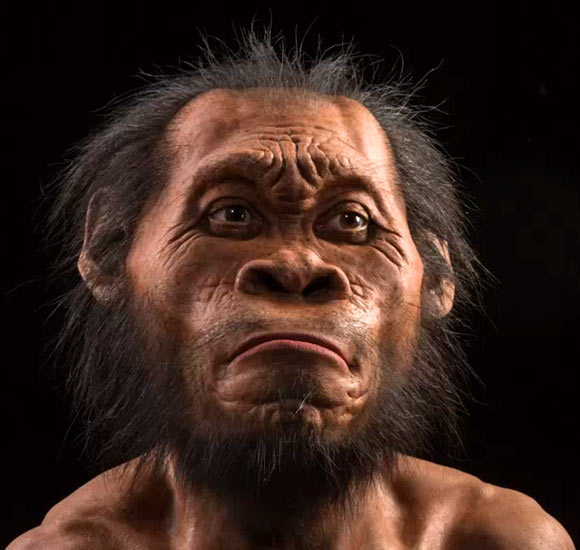
Reconstructed head of a somewhat annoyed Homo naledi. Credit: John Gurche, Mark Thiessen, National Geographic.
Nash was entrusted with these unique fossils by Lee Berger, Professor in Palaeoanthropology at Witwatersrand University, South Africa and a National Geographic Explorer-in-Residence. Berger recovered fossils of both species from limestone caves in the UNESCO World Heritage Site grandly named the Cradle of Humankind near Johannesburg. He is no stranger to controversy, and this venture cooked up with Nash seems to aim at promotion of South African achievements rather than having any scientific purpose. It has backfired spectacularly (see: McKie, R. 2023. ‘Callous, reckless, unethical’: scientists in row over rare fossils flown into space. The Observer, 22 October 2023). Comments from the anthropological world, six national and international bodies and perhaps the leading hominin specialist Professor Chris Stringer of the Natural History Museum in London include the words and phrases “callous”, “unethical”, “extraordinarily poorly thought-out”, “a publicity stunt”, “reckless” and “utterly irresponsible”. The caper breaks the South African, indeed international, scientific rule that fossils can only be allowed to travel for scientific purposes, applied consistently by similarly hominin-rich African countries such as Ethiopia, Kenya and Tanzania.
But, Hey, that’s how you get on in the world … isn’t it?
The theory of plate tectonics had a long gestation. Continental drift, one of its central tenets, was first proposed by the meteorologist Alfred Wegener in 1912. Apart from a few enthusiasts of such a dynamic aspect of geology, such as Alex du Toit and Arthur Holmes, the majority of geoscientists remained with the non-revolutionary fixist ideology of their Victorian predecessors. Wegener’s stumbling block was his proposed driving mechanism – polflucht (flight from the poles) – which assumed that supercontinents had formed in polar regions to be subject to centrifugal force resulting from Earth’s rotation. This broke them apart to be driven towards the Equator. Such a mechanism being easily invalidated, most contemporary geologists preferred to ‘throw Wegener’s baby out with the bathwater’. Yet every piece of his evidence that continents had moved around and most of his ideas about the nature of their movements were steadily verified and amplified over the next six decades, which attracted more curious and flexible scientists. What is now the central paradigm of the Earth Sciences had to wait for a set of major discoveries in the 1950s and ‘60s enabled by emerging technologies, such as the magnetometers used by Fred Vine and Drummond Matthews to discover sea-floor magnetic striping and thus sea-floor spreading. Their breakthrough presented a plausible mechanism for continental drift and launched a near frenzy of collaborative research among a global milieu of young geoscientists, one of whom being W. Jason Morgan.
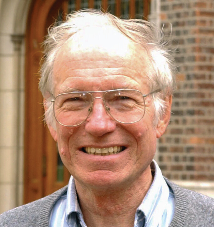
W. Jason Morgan outside the Department of Earth Sciences, Princeton University. (Credit: Denise Applewhite, Princeton University)
His initial interest was in the great fracture zones on the floors of the Atlantic and Pacific Oceans. He grasped that each of them was very nearly a great circle. This was a central key to unifying seafloor spreading and continental drift – to move across a spherical surface every point on the seafloor had to follow such a path. Morgan recognised that the fracture zones could only result from rigid plates having to fracture to accommodate that motion. Using spherical geometry he was able to link together ridges, trenches and these huge transform faults with poles of rotation and triple junctions to predict plate motions in a quantitative manner. That insight provided a key to active earthquakes, mountain belts and volcanoes. His scientific unification was a result of genius: in just a few weeks Morgan established the fundamentals of what became known as plate tectonics.
W. Jason Morgan was one of the revolutionaries who made geology dynamic and launched its resurrection from the boring province of damp field workers in anoraks tramping across tracts of extremely puzzling rocks and structures, noses to the ground. He died at the age of 87 on 31 July 2023.
White Sands National Park in New Mexico, USA is notorious for being adjacent to the site at which the first nuclear weapon was tested (code name Trinity) on 16 July 1945. Four weeks later two such bombs killed between 129,000 and 226,000 people at Hiroshima (6 August 1945) and Nagasaki (9 August 1945). The area is one of spectacular geology, the white sand being made of gypsum (CaSO4) grains precipitated from lake water supplied by rivers that had dissolved the mineral from Permian evaporites in the surrounding mountains. Subsequent wind erosion created a large, white dune field: the main attraction. Though a national park that has been proposed for UNESCO World Heritage Centre, the park itself is surrounded by military installations including the nuclear test site.
Gypsum sand dunes in White Sands National Park USA. (Credit: Wikipedia)
As in most evaporite basins, the White Sands’ gypsum sediments built up layer-by-layer through deposition of clays during successive inundations followed by evaporation of CaSO4 rich water. Animals crossing the basin were likely to leave trackways, which subsequent sedimentary cycles could preserve in stratigraphic order. Examples had been found in the early 20th century, revealing the former presence of the late-Pleistocene megafauna: Columbian mammoths, ground sloths, ancient camels, dire wolves, lions, and sabre-toothed cats. One set of dire wolf prints found in the 2010s contained seeds that yielded a radiocarbon age of 18 ka. More recently, 61 human footprint tracks turned up in layers that also displayed signs of megafauna crossing the lake flats, in one case showing convincing signs of hunters having followed a giant ground sloth (Bennett, M.R. 2021 and 13 others 2021. Evidence of humans in North America during the Last Glacial Maximum. Science, v. 373, p. 1528-1531; doi: 10.1126/science.abg7586). Interestingly, many of the human tracks seem to have been made by teenagers and children with only a few made by adults. Dating of seeds in the sediment layers – and in some footprints – yielded 23 to 21 ka radiocarbon ages. This evidence suggested human occupation of New Mexico long before those who left Clovis-style artifacts around 13 ka and others who preceded them. However, the seeds that were dated are those of an aquatic grass (Ruppia cirrhosa), which may have absorbed older carbon from groundwater permeating the evaporite sediments. Being robust, the seeds could also have been transported by wind back and forth from plants that lived before the animals and humans left their marks in the saline flats. Such is the importance of the White Sands fossil trackways that a team of US and British geologists, some of whom authored Bennett et al. 2021, have sought to refute doubts of their antiquity (Pigati, J.S. and 10 others 2023. Independent age estimates resolve the controversy of ancient human footprints at White Sands. Science, v. 382, p. 73-75; DOI: 10.1126/science.adh5007).
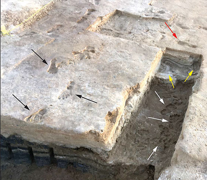
Human footprints (arrowed) preserved on three sediment surfaces of the White Sands clay-gypsum sequences; i.e. at three times in their depositional sequence. (Credit: from Pigati et al.; Fig 1)
The researchers cut trenches into the layered clay-gypsum to reveal human footprints on three successive surfaces at the site where Ruppia seeds had provided very old, but disputed ages. They supplemented the earlier evidence by 14C dating of pollen grains blown into the prints from terrestrial plants and optically stimulated luminescence ages (time of last exposure to sunlight) of detrital quartz grains in the evaporites. The pollen dating gave ages from 23.4 to 22.6 ka, the minimum quartz OSL age being 21.5 ka. Similar ages from three different methods are pretty convincing evidence that humans were active in New Mexico during the Last Glacial Maximum (LGM), and that absorption of older carbon from groundwater had not affected the Ruppia seeds.
The Asia to America migration, which led these hunters to what the abundant megafauna trackways suggest were rich pickings around the White Sands palaeo-lake, must have been earlier still. High-latitude North America was almost certainly a vast, frigid desert for thousands of years leading up to the LGM. Another implication of the remarkable finds in the gypsum beds is that migration most probably involved a coastal or even a maritime route along the Eastern Pacific shore to reach more habitable lower latitudes.
The Cretaceous-Palaeogene mass extinction is no longer an event that polarises geologists’ views between a slow volcanic driver (The Deccan large igneous province) and a near instantaneous asteroid impact (Chicxulub). There is now a broad consensus that both processes were involved in weakening the Late Cretaceous biosphere and snuffing out much of it around 66 Ma ago. Yet is still no closure as regards the details. From a palaeontologist’s standpoint the die-off varied dramatically between major groups of animals. For instance, the non-avian dinosaurs disappeared completely while those that evolved to modern birds did not. Crocodiles came through it largely unscathed unlike aquatic dinosaurs. In the seas those animals that lived in the water column, such as ammonites, were far more affected than were denizens of the seafloor. But much the same final devastation was visited on every continent and ocean. However, lesser and more restricted extinctions occurred before the Chicxulub impact.
Scientists from Norway, Canada, the US, Italy, the UK and Sweden have now thrown light on the possibility that climate change during the last half-million years of the Cretaceous may have been eroding biodiversity and disrupting ecosystems (Callegaro, S. et al. 2023. Recurring volcanic winters during the latest Cretaceous: Sulfur and fluorine budgets of Deccan Traps lavas. Science Advances, v. 9, article eadg8284; DOI: 10.1126/sciadv.adg8284). Almost inevitably, they turned to the record of Deccan volcanism that overlapped the K-Pg event, specifically the likely composition of the gases that the magmas may have belched into the atmosphere. Instead of choosing the usual suspect carbon dioxide and its greenhouse effect, their focus was on sulfur and fluorine dissolved in pyroxene grains from 15 basalts erupted in the 10 Formations of the Deccan flood-basalt sequence. From these analyses they were able to estimate the amounts of the two elements in the magma erupted in each of these 10 phases.
Exposed section through a small part of the Deccan Traps in the Western Ghats of Maharashtra, India. (Credit: Gerta Keller, Princeton University)
The accompanying image of a famous section through the Deccan Traps SE of Mumbai clearly shows that 15 sampled flows could reveal only a fraction of the magmas’ variability: there are 12 flows in the foreground alone. The mountain beyond shows that the pale-coloured sequence is underlain by many more flows, and the full Deccan sequence is about 3.5 km thick. Clearly, flood-basalt volcanism is in no way continuous, but builds up from repeated lava flows that can be as much as 50 m thick. Each of them is capped by a red, clay-rich soil or bole – from the Greek word bolos (βόλος) meaning ‘clod of earth’. Weathering of basalt would have taken a few centuries to form each bole. Individual Deccan flows extend over enormous areas: one can be traced for 1500 km. At the end of volcanism the pile extended over roughly 1.5 million km2 to reach a volume of half a million km3.
Fluorine is a particularly toxic gas with horrific effects on organisms that ingest it. In the form of hydrofluoric acid (HF) – routinely used to dissolve rock – it penetrates tissue very rapidly to react with calcium in the blood to form calcium fluoride. This causes very severe pain, bone damage and other symptoms of skeletal fluorosis. The 1783-4 eruption of the Laki volcanic fissure in Iceland emitted an estimated 8,000 t of HF gas that wiped out more than half the domestic animals as a result of their eating contaminated grass. The famine that followed the eruption killed 20 to 25% of Iceland’s people: exhumed human skeletons buried in the aftermath show the distinctive signs of endemic skeletal fluorosis. This small flood-basalt event had global repercussions, as the Wikipedia entry for Laki documents. Volcanic sulfur emissions in the form of SO2 gas react with water vapour to form sulphuric acid aerosols in a reflective haze. If this takes place in the stratosphere as a result of powerful eruptions, as was the case with the 1991 Pinatubo eruption in the Philippines, the high-altitude haze lingers and spreads. This results in reduced solar warming: a so-called ‘volcanic winter’. In the Pinatubo aftermath global temperatures fell by about 0.5°C during 1991-3. Unsurprisingly, volcanic sulfur emissions also result in acid rainfall. Moreover, inhaling the sulphur-rich haze at low altitudes causes victims to choke as their respiratory tissues swell: an estimated 23,000 people in Britain died in this way when the 1783-4 Laki eruption haze spread southwards Sara Calegaro and colleagues found that the fluorine and sulfur contents of Deccan magmas fluctuated significantly during the eruptive phases. They suggest that fluorine emissions were far above those from Laki, perhaps leading to regional fluorine toxicity around the site of the Deccan flood volcanism but not extinctions. Global cooling due to sulphuric acid aerosols in the stratosphere is suggested to have happened repeatedly, albeit briefly, as eruption waxed and waned during each phase. Magmas rich in volatiles would have been more likely to erupt explosively to inject SO2 to stratospheric altitudes (above 10 to 20 km). The authors do not attempt to model when such cooling episodes may have occurred: data from only 15 levels in the Deccan Traps do not have the time-resolution to achieve that. They do, however, show that this large igneous province definitely had the potential to generate ‘volcanic winters’ and toxic episodes. Time and time again ecosystems globally and regionally would have experienced severe stress, the most important perhaps being disruption of the terrestrial and marine food chains.
Without seafaring skills and sturdy boats, ancient humans had only two options to leave Africa for Eurasia: by crossing the Straits of Bab el Mandab at the southern end of the Red Sea and from the Nile delta to the Levant at its northern end. Both would have been difficult. The first route demanded extremely low sea level drawn down by continental ice accumulation to narrow the sea crossing, the earliest in the last glacial cycle being around 70 ka ago. The northern route, with no sea crossing, was potentially achievable throughout the history of the genus Homo. But that way is beset to the north and east by deserts with large tracts that today lack natural water sources. To leave Africa by that route seems the most obvious, being reached along the well-watered Nile valley or the Red Sea coast with its abundant marine resources. Yet moving eastwards to Arabia and further would have required climatic windows of opportunity to ensure well-watered corridors: it would be impossible today without an infrastructure of wells; and edible resources are extremely sparse. Remains of anatomically modern humans (AMH) as old as 200 ka and others in the period between 130 to 85 ka have been found around the eastern shores of the Mediterranean. Either of the two routes could have led them there during periods of increased humidity, perhaps in a series of migratory pulses. In the case of an exodus across the Straits of Bab el Mandab, people could have moved northwards along the Red Sea coast of modern Yemen and Arabia to the Levant. However, the record is patchy, and there is no direct fossil evidence to suggest they went further, into southern Asia or Europe in these earlier times. Each early venture may also have ended in extinction. The first presence of AMH in Asia and Europe, seems to have been tens of thousand years later: about 75 ka and 45 ka, respectively, so far as we know.
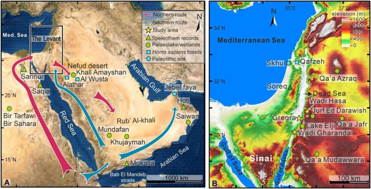
Left: Satellite image of the Arabia and the Levant, showing the possible northern (red) and southern migration routes (blue) and sites that yielded various palaeoclimatic signs of formerly wet areas, Homo sapiens fossils and stone tools (see key). Right colour-coded map of topographic elevation for the study area in the Levant with sites that reveal palaeoclimatic and anthropological information. (Credit: Abbas et al., Fig 1)
Research in the Arabian Peninsula has early recorded human presence from discarded stone artefacts at widely scattered sites, as far east as the UAE and Oman, but whether these were carried by AMH or other human groups is uncertain. Yet geological research suggests that even in the presently forbidding Empty Quarter of Saudi Arabia there were from time to time abundant springs, river networks and even lakes: occasionally climate changes made much of Arabia habitable. Researchers from the University of Southampton (UK) and Shantou University (China), together with colleagues in Jordan, Australia and the Czech Republic have documented further evidence for ‘green’ episodes on the Jordan Plateau – part of the currently hyperarid Arabian interior (Abbas, M. and 10 others 2023. Human dispersals out of Africa via the Levant. Science Advances, v.9, article eadi6838; DOI: 10.1126/sciadv.adi6838).
Three sites in Jordan reveal wetland sediments incised by now dry channels or wadis, one of which yielded stone tools Luminescence dating of wetland sediment grains shows the times when they were last exposed to sunlight: some between 86 to 65 ka, others between 57 to 43 ka. Together with data from the rest of Arabia the sites help roughly to define routes that would have permitted human migration, though not the actual directions that early AMH might have travelled or their destinations – if any. They may just have wandered around surviving on the resources that they found during short periods of amenable local climate, and vegetation much as do desert dwellers today. Actually to exit Arabia to southern Asia would require migration around what is now the Persian Gulf, where relevant data are lacking and likely to remain so while poor security for research prevails. To get to Europe would require a much more intricate journey through large mountainous tracts to reach the shores of the Black Sea.