Impact debris in Neoproterozoic sediments of Scotland and biological evolution?

False-colour electron microscope image of a shocked grain of zircon recovered from the Stac Fada Member. The red and pink material is a high-pressure polymorph of zircon, arranged in shock lamellae. Zircon is rendered in cyan, some of which is in granulated form. Credit: Kirkland et al. 2025, Fig 2C

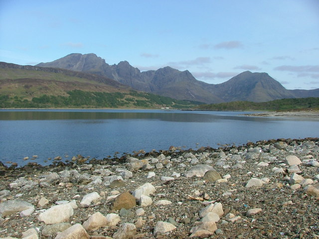
Judging by its content of shards and spherules made of murky green glass, one of the lowest units in the Torridonian continental sediments of NW Scotland had long been regarded as simply red sandstone that contained volcanic debris. This Stac Fada Member was thus celebrated as the only sign of a volcanic contribution to a vast thickness (up to 2.5 km) of Neoproterozoic lake and fluviatile sediments. Current flow indicators suggested that the Torridonian was laid down by large alluvial fans derived by erosion of much older crystalline basement far to what is today the west. That is, the Archaean core of the ancient continent of Laurentia, now the other side of the North Atlantic. In 2002 more sophisticated sedimentological and geochemical analysis of the Stac Fada Member revealed a surprise: it contains anomalously elevated platinum-group elements, quartz grains that show signs of shock and otherworldly chromium isotope concentrations. The 10 m thick bed is made from ejecta, perhaps from a nearby impact crater to the WNW concluded from brittle fractures that may have been produced by the impact. Some idea of its age was suggested by Ar-Ar dating of feldspar crystals (~1200 Ma) believed to have formed authigenically in the hot debris. Being the only decent impactite known in Britain, it continues to attract attention.

A group of geoscientists from Western Australia, NASA and the UK, independent of the original discoverers, have now added new insights ( Kirkland, C.L. and 12 others 2025. A one-billion-year old Scottish meteorite impact. Geology, v. 53, early online publication; DOI: 10.1130/G53121.1). They dated shocked zircon grains using U-Pb analyses at 990 ± 22 Ma; some 200 Ma younger than the previously dated, authigenic feldspars.  Detrital feldspar grains in the Stac Fada Member yield Rb-Sr radiometric ages of 1735 and 1675, that are compatible with Palaeoproterozoic granites in the underlying Lewisian Gneiss Complex.

Photomicrograph of Bicellum brazieiri: scale bar = 10μm; arrows point to dark spots that may be cell nuclei (credit: Charles Wellman, Sheffield University)

In a separate publication (Kirkland, C.L et al 2025. 1 billion years ago, a meteorite struck Scotland and influenced life on Earth. The Conversation, 29 April 2025) three of the authors take things a little further, as their title suggests. In this Conversation piece they ponder, perhaps unwarily, on the spatial and temporal association of the indubitable impact with remarkably well-preserved spherical fossils found in Torridonian lake-bed sediments (Bicellum brasieri, reported in Earth-logs in May 2021), which are the earliest-known holozoan animal ancestors. The Torridonian phosphatic concretions in which these important fossils were found at a different locality are roughly 40 Ma younger than the Stac Fada impactite. The authors of the Conversation article appeal to the residual thermal effect of the impact as a possible driver for the appearance of these holozoan organisms. Whether a residual thermal anomaly would last long enough for them to evolve to this biological status would depend on the magnitude of the impact, of which we know nothing.  Eukaryote fossils are known from at least  650 Ma older sedimentary rocks in northern China and perhaps as far back as 2.2 Ga in a soil that formed in the Palaeoproterozoic of South Africa. Both the Torridonian organism and impactite were found in a small area of fascinating geology that has been studied continuously in minute detail since Victorian times, and visited by most living British geologists during their undergraduate days. Ideas will change as curiosity draws geologists and palaeobiologists to less-well studied sites of Proterozoic antiquity, quite possibly in northern China.

A fully revised edition of Steve Drury’s book Stepping Stones: The Making of Our Home World can now be downloaded as a free eBook

Provenance of the Stonehenge Altar Stone: a puzzling development

 Curiously, two weeks after my previous post about Stonehenge, a wider geochemical study of the Devonian sandstones and a number of Neolithic megaliths in Orkney seems to have ruled out the Stonehenge Altar Stone having been transported from there (Bevins, R.E. et al. 2024. Was the Stonehenge Altar Stone from Orkney? Investigating the mineralogy and geochemistry of Orcadian Old Red sandstones and Neolithic circle monumentsJournal of Archaeological Science: Reports, v. 58, article 104738;   DOI: 10.1016/j.jasrep.2024.104738). Since two of the authors of Clarke et al. (2024) were involved in the newly published study, it is puzzling at first sight why no mention was made in that paper of the newer results. The fact that the topic is, arguably, the most famous prehistoric site in the world may have generated a visceral need for getting an academic scoop, only for it to be dampened a fortnight later. In other words, was there too much of a rush?

The manuscript for Clarke et al. (2024) was received by Nature in December 2023 and accepted for publication on 3 June 2024; a six-month turnaround and plenty of time for peer review. On the other hand, Bevins et al. (2024) was received by the Journal of Archaeological Science on 23 July 2024, accepted a month later and then hit the website a week after that: near light speed in academic publishing. And it does not refer to the earlier paper at all, despite two of its authors’ having contributed to it. Clarke et al. (2024) was ‘in press’ before Bevins et al. (2024) had even hit the editor’s desk. The work that culminated in both papers was done in the UK, Australia, Canada and Sweden, with some potential for poor communication within the two teams. Whatever, the first paper dangled the carrot that Orkney might have been the Altar Stone’s source, on the basis of geochemical evidence that the grains that make up the sandstone could not have been derived from Wales but were from the crystalline basement of NE Scotland. The second shows that this ‘most popular’ Scottish source may be ruled out. To Orcadians and the archaeologists who worked there, long in the shade of vast outpourings from Salisbury Plain, this might come as a great disappointment.

Cyclical sediments of the Devonian Stromness Flagstones. (Credit Mike Norton, Wikimedia)

The latest paper examines 13 samples from 8 outcrops of the Middle Devonian Stromness Flagstones strata in the south of the main island of Orkney close to the Ring of Brodgar and the Stones of Stenness, and the individual monoliths in each. On the main island, however, there is a 500 m sequence of Stromness Flagstones in which can be seen 50 cycles of sedimentation. Each cycle contains sandstone beds of various thicknesses and textures. They are fluviatile, lacustrine or aeolian in origin. So the Neolithic builders of Orkney had a wide choice, depending on where they erected monumental structures. Almost certainly they chose monolithic stones where they were most easy to find: close to the coast where exposure can be 100 %. The Ring of Brodgar and the Stones of Stenness are not on the coast, so the enormous stones would have to be dragged there. There is an ancient pile of stones (Vestra Fiold) about 20 km to the NW where some of the mmegaliths may have been extracted, but ancient Orcadians would have been spoilt for choice if they had their hearts set on erecting monoliths!

In a nutshell, the geological case made by Bevins et al. (2024) for rejecting Orkney as the source for the Stonehenge Altar Stone (AS) is as follows: 1. Grains of the mineral baryte (BaSO) present in the AS are only found in two of the Orkney rock samples. 2. All the Orcadian sandstone samples contain lots of grains of K-feldspar (KAlSi3O8) – common in the basement rocks of northern Scotland – but the AS contains very little. 3. A particular clay mineral (tosudite) is plentiful in the AS, but was not detected in the rock samples from Orkney. Does that rule out a source in Orkney altogether? Well, no: only the outcrops and megalith samples involved in the study are rejected.

To definitely negate an Orcadian source would require a monumental geochemical and mineralogical study across Orkney; covering every sedimentary cycle. Searching the rest of the Old Red Sandstone elsewhere in NE Scotland – and there is a lot of it – would be even more likely to be fruitless. Tracking down the source for the basaltic bluestones at Stonehenge was easy by comparison, because they crystallised from a particular magma over a narrow time span and underwent a specific degree of later metamorphism. They were easily matched visually and under the microscope with outcrops in West Wales in the 1920s and later by geochemical features common to both.

But all that does not detract from the greater importance of the earlier paper (Clarke et al., 2024), which enhanced the idea of Neolithic cultural coherence and cooperation across the whole of Britain. The building of Stonehenge drew people from the far north of Scotland together with those of what are now Wales and England. Since then it hasn’t always been such an amicable relationship …

See also:  Addley, E. 2024. Stonehenge tale gets ‘weirder’ as Orkney is ruled out as altar stone origin. The Guardian 5 September 2024.

Sudden climate change: a warning from 8 millennia ago

Mesolithic hunter-gatherers in Britain must have had a very hard time around 8.2 thousand years age. The whole area around the North Atlantic experienced sudden climatic cooling of around 3.3°C together with drought that lasted about 70 years. To make things worse shortly afterwards, coasts around the North were devastated by a tsunami generated by a submarine landslide off western Norway. That event exceeded the maximum coast ‘run up’ of both the 26 December 2004 Indian Ocean tsunami and that in NW Japan on 11 March 2011. Doggerland, then in the central North Sea was devastated by a catastrophic event of a few days duration. It littered the seabed with the bones of its megafauna and even Mesolithic tools recovered by trawlers from its surviving relic the shallow Dogger Bank. It seems the tsunami arrived just as climate was warming back to ‘normal’ Holocene conditions: for many foragers, surely, a last straw.

The cooling episode has been attributed to perturbation of the Atlantic Meridional Overturning Circulation (AMOC) as a result of meltwater discharge during the deglaciation of the Laurentide Ice Sheet (see: Just when you think it’s going to turn out alright… November 2009).The event may have unfolded in a similar fashion to the trigger for the Younger Dryas and the succession of warming-cooling episodes known as Dansgaard-Oeschger events that interrupted the otherwise relentless global cooling towards the last glacial maximum (see: Review of thermohaline circulation; February 2002). The physics that set off such climatic ‘hiccups’ is that freshening of surface seawater reduces its density, so that it cannot sink to be replaced by denser saline water ‘dragged’ northwards from warmer latitudes. That currently takes the form of the Gulf Stream with its warming influence, particularly in the eastern North Atlantic and even beyond Norway’s North Cape, responsible for much warmer winters than at similar latitudes on the western side. The culprit  had long been suggested to be the drainage of a huge lake dammed by the ice sheet that covered most of eastern Canada during late stages of deglaciation. Seemingly the best candidate was Lake Agassiz trapped by the early Holocene ice front in Manitoba – the largest proglacial lake known anywhere.

Colour coded topographic elevation of North America showing the maximum extent of Lake Agassiz and four possible routes for its drainage: north-west to the Arctic Ocean via the Mackenzie River; south to the Gulf of Mexico via the Mississippi valley; east to the North Atlantic via the Great Lakes and St Laurence River; north to the North Atlantic via Hudson Bay. (Credit: ©Sheffield University)

The present landforms of central Canada show evidence for several outflow directions at different times, Including to the northwest to reach the Arctic Ocean at the onset of the Younger Dryas. Until recently there was little detailed evidence for the flow volume and timing of its drainage around 8 to 9 ka. Providing the details in the context of the short-lived event around 8.2 ka requires accurate data over a mere 200 years able to reveal a change in sea level to a precision of better than a few tens of centimetre. Any site on the shores of the North Atlantic would do, provided it satisfies these criteria. Geographers from universities in York, Leeds, Sheffield and Oxford, UK selected the small estuary of the River Ythan in NE Scotland. There, a continuous sand unit just above fine-grained intertidal tidal muds marks the knife-sharp time datum of the Storegga tsunami (Rush, G. et al. 2023. The magnitude and source of meltwater forcing of the 8.2 ka climate event constrained by relative sea-level data from eastern Scotland. Quaternary Science Advances, v. 12, article 100119; DOI: 10.1016/j.qsa.2023.100119).

Cores of the intertidal sediments from beneath the present Ythan salt marsh contain plant remains that yielded precise radiocarbon dates at several stratigraphic levels from which to derive an age-depth model for the age range of interest. The buried sediments are also rich in marine microfossils (foraminifera and diatoms) that thrive in estuaries at a variety of depths.  These enabled fluctuations in relative sea level during the build-up of the intertidal sediments to be constrained at unprecedented resolution and precision for a three thousand year period from 9.5 to 6.5 ka. The authors show that there were two episodes of rapid sea-level rise over that time: between 8.53 and 8.37 ka (~2.4 m at 13 mm yr-1) and 8.37 to 8.24 ka (~ 0.6 m at 4 mm yr-1) – these would have been global increases in sea level.

Despite its vast size, it turns out that Lake Agassiz would have been unable to result in sea-level rises of that magnitude so quickly merely through outflow. Rush et al. suggest that the huge  and rapid addition of fresh water to the North Atlantic involved flow of lake water towards Hudson Bay, beneath the ice sheet, causing it to collapse and melt, followed by completion of Lake Agassiz’s emptying in the second stage. It took a long drawn-out ‘freshening’ of the North Atlantic surface water ultimately to shut down the Atlantic Meridional Overturning Circulation, thereby depriving high latitudes of its east-side warming effect by the Gulf Stream.

Sea level has been rising since the early 20th century mainly through the melting of Greenland’s ice cap together with a substantial amount of thermal expansion while global climate has been warming. Between 1901 and 2018 the rise has amounted to 15 to 25 cm at a rate of 1 to 2 mm yr-1. The AMOC is possibly weaker now than at any time during the last millennium (Zhu, C. et al. 2023. Likely accelerated weakening of Atlantic overturning circulation emerges in optimal salinity fingerprint. Nature Communications, v. 14, article 1245; DOI: 10.1038/s41467-023-36288-4). Yet increases in freshening of the northernmost parts of the North Atlantic are now being added to by annual increases in the melting of polar sea ice, which is salt-free. The AMOC may be approaching a tipping point, because warming is accelerating over Greenland at around 1.5°C each year: faster than most of the rest of the world. In 2021 it rained for the first time ever recorded at the ice cap’s summit (3.2 km above sea level). A ‘perturbation’ of the AMOC would add chaos to the dominantly linear view of global warming taken by climatologists. That could launch frigidity and drought at mid northern latitudes as it did eight millennia ago: the opposite of what is currently feared.

See also: Unlocking Ancient Climate Secrets – Melting Ice Likely Triggered Climate Change Over 8,000 Years Ago. Scitechdaily 16 September 2023.

A major Precambrian impact in Scotland

The northwest of Scotland has been a magnet to geologists for more than a century. It is easily accessed, has magnificent scenery and some of the world’s most complex geology. The oldest and structurally most tortuous rocks in Europe – the Lewisian Gneiss Complex – which span crustal depths from its top to bottom, dominate much of the coast. These are unconformably overlain by a sequence of mainly terrestrial sediments of Meso- to Neoproterozoic age – the Torridonian Supergroup – laid down by river systems at the edge of the former continent of  Laurentia. They form a series of relic hills resting on a rugged landscape carved into the much older Lewisian. In turn they are capped by a sequence of Cambrian to Lower Ordovician shallow-marine sediments. A more continuous range of hills no more than 20 km eastward of the coast hosts the famous Moine Thrust Belt in which the entire stratigraphy of the region was mangled between 450 and 430 million years ago when the elongated microcontinent of Avalonia collided with and accreted to Laurentia.  Exposures are the best in Britain and, because of the superb geology, probably every geologist who graduated in that country visited the area, along with many international geotourists. The more complex parts of this relatively small area have been mapped and repeatedly examined at scales larger than 1:10,000; its geology is probably the best described on Earth. Yet, it continues to throw up dramatic conclusions. However, the structurally and sedimentologically simple Torridonian was thought to have been done and dusted decades ago, with a few oddities that remained unresolved until recently.

NW Scotland geol
Grossly simplified geological map of NW Scotland (credit: British Geological Survey)

Continue reading “A major Precambrian impact in Scotland”

Impact debris in Britain

These days reports of geological evidence for asteroid impacts are not regarded with a mixture of disbelief, wonder and foreboding: well, not by geologists anyway. But for such a small area as Britain now to have three of widely different ages and in easily accessible places is pretty good for its brand as the place to visit for practically every aspect of Earth history. The first to be discovered lies at the base of Triassic mudstones near Bristol (see Britain’s own impact) and would need some serious grubbing around at a former construction site. The next to emerge was located in one of the best geological districts in the country at several easily accessed coastal exposures in Northwest Scotland. A glass-rich ejecta layer occurs in the basal Torridonian Stoer Group on Stac Fada, Stoer, Sutherland (UK National Grid Reference 203300, 928400). The most recently found (Drake, S.N. and 8 others 2018. Discovery of a meteoritic ejecta layer containing unmelted impactor fragments at the base of Paleocene lavas, Isle of Skye, Scotland. Geology, v. 46, p. 171-174; doi:10.1130/G39452.1) is on the Inner Hebridean island of Skye at the base of its famous Palaeocene flood basalt sequence (UK National Grid Reference 155371,821112).

View to the northwest across Loch Slapin to the Cuillin Hills of Skye (Central Igneous Complex). The flood basalts beneath which the ejecta layer occurs are just above the trees. (Credit: Wikipedia)

The last is perhaps the most spectacular of the three, as it contains the full gamut of provenance, matched only by material from the drill core into the 66 million year-old Chicxulub crater. The 0.9 m thick debris layer rests directly on mid-Jurassic sandstones beneath Palaeocene basalts of the North Atlantic Igneous Province (NAIP). The layer contains a basalt clast dated at 61.54 Ma, but is dominantly reminiscent of a pyroclastic ignimbrite flow as it contains glass shards. But there the resemblance ends for the bulk of small clasts are of quartz and K-feldspar, sandstone and gneiss. Zircons extracted from the debris show shock lamellae and give Archaean and Proterozoic ages commensurate with the local basement, but also with the bulk of the Scandinavian and Canadian Shields. So the impact could have been anywhere in such widespread terrains, although the enclosed basalt narrows this down to areas where basement is overlain by lavas of the NAIP. The Skye impactite contains unmelted meteorite fragments in the form of titanium nitrides alloyed with vanadium and niobium, metallic iron-silicon alloy containing exsolved carbon, and manganese sulfide.

Although it may be coincidental, the situation of the ejecta layer immediately beneath the Skye lavas, its containing a clast of basalt whose age corresponds to the oldest flows anywhere in the NAIP is fascinating. But the actual impact site is, as yet, unknown. Even so, the layer provokes thoughts about whether an impact may have been more than spatially related to the large NAIP flood basalt pile, preserved on either side of the North Atlantic. If the event was large, then surely the ejecta should be preserved near the base of the flood basalts elsewhere in NW Britain and further afield