The final closure of the Iapetus Ocean

A symposium hosted by the Royal Society in 1965 aimed at resurrecting Alfred Wegener’s hypothesis of continental drift. During the half century since Wegener made his proposal in 1915, it had been studiously ignored by most geologists. The majority had bumbled along with the fixist ideology of their Victorian predecessors. The symposium launched what can only be regarded as a revolution in the Earth Sciences. In the three years following the symposium, the basic elements of plate tectonics had emerged from a flurry of papers, mainly centred on geophysical evidence. Geology itself became part of this cause célèbre through young scientists eager to make a name for themselves. The geological history of Britain, together with that of the eastern North America, became beneficiaries only four years after the Royal Society meeting (Dewey, J. 1969. Evolution of the Appalachian/Caledonian Orogen. Nature 222, 124–129; DOI: 10.1038/222124a0).

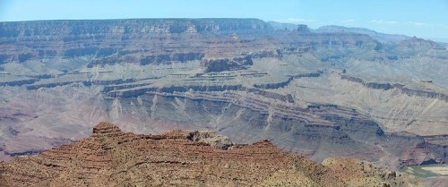
In Britain John Dewey, like a few other geologists, saw plate theory as key to understanding the many peculiarities revealed by geological structure, igneous activity and stratigraphy of the early Palaeozoic. These included very different Cambrian and Ordovician fossil assemblages in Scotland and Wales, now only a few hundred kilometres apart. The Cambro-Ordovician of NW Scotland was bounded to the SE by a belt of highly deformed and metamorphosed Proterozoic to Ordovician sediments and volcanics forming the Scottish Highlands. That was terminated to the SE by a gigantic fault zone containing slivers of possible oceanic lithosphere. The contorted and ‘shuffled’ Ordovician and Silurian sediments of the Southern Uplands of Scotland. The oldest strata seemed to have ocean-floor affinities, being deposited on another sliver of ophiolites.  A few tens of km south of that there was a very different Lower Palaeozoic stratigraphy in the Lake District of northern England. It included volcanic rocks with affinities to those of modern island arcs. A gap covered by only mildly deformed later Palaeozoic shelf and terrestrial sediments, dotted by inliers of Proterozoic sediments and volcanics separated the Lake District from yet another Lower Palaeozoic assembly of arc volcanics and marine sediments in Wales. Intervening in Anglesey was another Proterozoic block of deformed sediments that also included ophiolites.

Dewey’s tectonic assessment from this geological hodge-podge, which had made Britain irresistible to geologists through the 19th and early 20th centuries, was that it had resulted from blocks of crust (terranes), once separated by thousands of kilometres, being driven into each other. Britain was thus formed by the evolution and eventual destruction of an early Palaeozoic ocean, Iapetus: a product of plate tectonics. Scotland had a fundamentally different history from England and Wales; the unification of several terranes having taken over 150 Ma of diverse tectonic processes. Dewey concluded that the line of final convergence lay at a now dead, major subduction zone – the Iapetus Suture – roughly beneath the Solway Firth. During the 56 years since Dewey’s seminal paper on the Caledonian-Appalachian Orogeny details and modifications have been added at a rate of around one to two publications per year. The latest seeks to date when and where the accretion of 6 or 7 terranes was finally completed (Waldron, J.W.F. et al. 2025. Is Britain divided by an Acadian suture?  Geology, v. 53, p. 847–852; DOI: 10.1130/G53431.1).

Kernel density plots – smoothed versions of histograms – of detrital zircon ages in Silurian and Devonian sandstones from Wales. The bracketed words are stratigraphic epochs. Credit: Waldron et al. 2025, Fig 3A

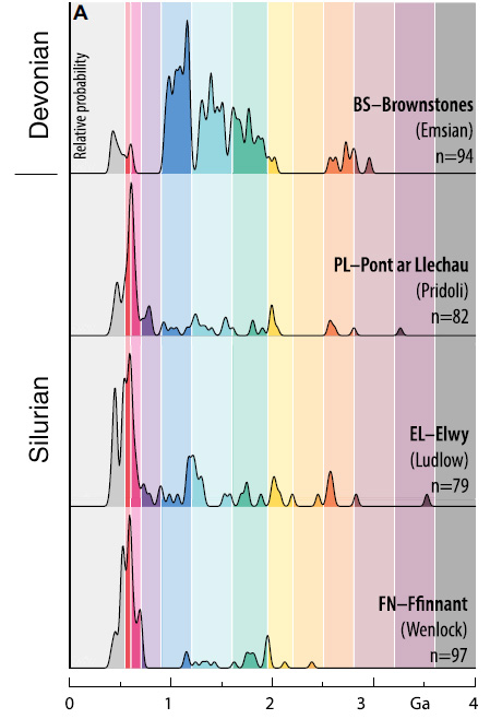
John Waldron and colleagues from the University of Alberta and Acadia University in Canada and the British Geological Survey addressed this issue by extracting zircons from four late Silurian and early Devonian sandstones in North and South Wales. These sediments had been deposited between 433 and 393 Ma ago at the southernmost edge of the British Caledonide terrane assemblage towards the end of terrane assembly. The team dated roughly 250 zircons from each sandstone using the 207Pb/206Pb and 206Pb/238U methods. Each produced a range of ages, presumed to be those of igneous rocks from whose magma the zircon grains had crystallised. These data are expressed as plots of probable frequency against age.  Each pattern of ages is assumed to be a ‘fingerprint’ for the continental crust from which the zircons were eroded and transported to their resting place in their host sediment. In this case, the researchers were hoping to see signs of continental crust from the other side of the Caledonian orogen; i.e. from the Precambrian basement of the Laurentia continent.

The three late-Silurian sediments showed distinct zircon-age peaks around 600 Ma and a spread of smaller peaks extending to 2.2 Ga. This tallied with a sediment source in Africa, from which the southernmost Caledonian terrane was said to have split and moved northwards.  The Devonian sediment lacked signs of such an African ‘heritage’ but had a prominent age peak at about 1.0 Ga, absent from the Welsh Silurian sediments.  Not only is this a sign of different sediment provenance but closely follows the known age of a widespread magmatic pulse in the Laurentian continent. So, sediment transport from the opposite side of the Iapetus Ocean across the entire Caledonian orogenic belt was only possible after the end of the Silurian Period at around 410 Ma. There must have been an intervening barrier to sediment movement from Laurentia before that, such as deep ocean water further north. Previous studies from more northern Caledonian terranes show that Laurentian zircons arrived in the Southern Uplands of Scotland and the English Lake District around 432 Ma in the mid-Silurian. Waldron et al. suggest, on these grounds that the suture marking the final closure of the Iapetus Ocean lies between the English Lake District and Anglesey, rather than beneath the Solway. They hint that the late-Silurian to early Devonian granite magmatism that permeated the northern parts of the Caledonian-Appalachian orogen formed above northward subduction of the last relics of Iapetus, which presaged widespread crustal thickening known as the Acadian orogeny in North America.

Readers interested in this episode of Earth history should download Waldron et al.’s paper for its excellent graphics, which cannot be reproduced adequately here.

Sagduction of greenstone belts and formation of Archaean continental crust

Simplified geological map of the Archaean Yilgarn Craton in Western Australia. Credit: Geological Survey of Western Australia

Every ancient craton seen from space shows patterns that are unique to Archaean continental crust: elongated, ‘canoe-shaped’ greenstone belts enveloped by granitic gneisses, both of which are punctured by domes of younger, less deformed granites. The Yilgarn Craton of Western Australia is a typical granite-greenstone terrain. Greenstone belts contain lavas of ultramafic, basaltic and andesitic compositions, which in undeformed settings show the typical pillow structures formed by submarine volcanic extrusion. There are also layered mafic to ultramafic complexes, formed by fractional crystallisation, minor sedimentary sequences and occasionally more felsic lavas and ashes. The enveloping grey gneisses are dominantly highly deformed tonalite-trondhjemite-granodiorite (TTG) composition that suggest that they formed from large volumes of sodium-rich, silicic magmas, probably generated at depth by partial melting of hydrated basaltic rocks.

The heat producing radioactive isotopes of potassium, uranium and thorium in both the Archaean mantle and crust would have been more abundant before 2.5 Ga ago, because they decay over time. Consequently the Earth’s interior would have then generated more heat than now, gradually to escape by thermal conduction towards the cooler surface. The presence of pillow lavas and detrital sediments in greenstone belts indicate that surface temperatures during the Archaean Eon were below the boiling point of water; in fact probably much the same as in the tropics at present. Indeed there is evidence that Earth was then a water world. It may even have been so during the Hadean, as revealed by the oxygen-isotope data in 4.4 Ga zircon grains. The broad conclusion from such findings is that the Archaean geothermal gradient was much steeper; there would have been a greater temperature increase with depth than now and new crust would have cooled more slowly. Subduction of cool lithosphere would have been less likely than in later times, especially as higher mantle heat production would have generated new crust more quickly. Another likely possibility is that far more heat would have been moved by convection: there would have been more mantle-penetrating plumes and they would have been larger. Large mantle plumes of the Phanerozoic have generated vast ocean floor plateaus, such as the Kerguelen and Ontong Java Plateau.

A group of geoscience researchers at The University of Hong Kong and international colleagues recently completed a geological and geochemical study of the North China Craton, analysing their data in the light of recently emerging views on Archaean processes (Dingyi Zhao et al, A two-stage mantle plume-sagduction origin of Archean continental crust revealed by water and oxygen isotopes of TTGs, Science Advances, v. 11, article eadr9513  ; DOI: 10.1126/sciadv.adr9513).They found compelling evidence that ~2.5 Ga-old Neoarchaean TTG gneisses in the North China granite-greenstone terrain formed by partial melting of an earlier mafic-ultramafic greenstone crust with high water content. They consider this to support a two-stage model for the generation of the North China Craton’s crust above a vast mantle plume. The first stage at around 2.7 Ga was the arrival of the plume at the base of the lithosphere, which partially melted as a result of the decompression of the rising ultramafic plume. The resulting mafic magma created an oceanic plateau partly by underplating the older lithosphere, intruding it and erupting onto the older ocean floor. This created the precursors of the craton’s greenstones, the upper part of which interacted directly with seawater to become hydrothermally altered. They underwent minor partial melting to produce small TTG intrusions. A second plume arriving at ~2.5 Ga resulted in sinking of the greenstones under their own weight to mix or ‘hybridise’ with the re-heated lower crust. This caused the greenstones substantially to partially melt and so generate voluminous TTG magmas that rose as the greenstones subsided. . It seems likely that this dynamic, hot environment deformed the TTGs as they rose to create the grey gneisses so typical of Archaean granite-greenstone terranes. [Note: The key evidence for Dingyi Zhao et al.’s conclusions is that the two TTG pulses yielded the 2.7 and 2.5 Ga ages, and show significantly different oxygen isotope data (δ18O)].

Two stages of TTG gneiss formation in the North China Craton and the sinking (sagduction) of greenstone belts in the second phase. Credit: Dingyi Zhao et al., Fig 4)

Such a petrogenetic scenario, termed sagduction by Dingyi Zhao and colleagues, also helps explain the unique keel-like nature of greenstone belts, and abundant evidence of vertical tectonics in many Archaean terrains (see: Vertical tectonics and formation of Archaean crust; January 2002), Their model is not entirely new, but is better supported by data than earlier, more speculative ideas. That such processes have been recognised in the Neoarchaean – the North China Craton is one of the youngest granite-greenstone terrains – may well apply to far older Archaean continental crust generation. It is perhaps the last of a series of such events that began in the Hadean, as summarised in the previous Earth-logs post.

The world’s oldest crust in the Nuvvuagittuq Greenstone Belt, Quebec

Since 1999, the rocks generally acknowledged to be the oldest on Earth were part of the Acasta gneisses in the Slave Craton in Canada’s Northwest Territories; specifically the Idiwhaa tonalitic gneisses. Zircons extracted from that unit yielded an age of 4.02 billion years (Ga) using U-Pb radimetric dating, revealing the time of their crystallisation from granitic magma. But nine years later some metabasaltic rocks from the tiny (20 km2) Nuvvuagittuq Greenstone Belt on the eastern shore of Hudson Bay were dated using the Sm-Nd method at almost 4.3 Ga (see: At last, 4.0 Ga barrier broken; November 2008). Taken at face value the metabasaltic rocks seemed to be well within the Hadean Eon (4.6 to 4.0 Ga) and could thus represent primary crust of that antiquity. However, U-Pb dating of zircons from thin sodium-rich granitic rocks (trondhjemites) that intrude them yielded ages no older than about 3.8 Ga. Similar ages emerged from zircons found in metasediments interleaved in the dominant mafic unit. Discrepancies between the two completely different dating methods resulted in the Hadean antiquity of the mafic rocks having been disputed since 2008. It was possible that the Sm-Nd results from the metabasalts may have resulted from the original mafic magmas having inherited a Hadean Sm-Nd isotopic ‘signature’ from their mantle source. That is, they may have been contaminated and could have formed in the early Archaean.

Glacially smoothed outcrops near Inukjuak, Quebec that reveals rocks of the Nuvvuagittuq Greenstone Belt. Credit: Jonathan O’Neil, University of Ottawa

Jonathan O’Neil, now at Ottawa University in Canada, led the first isotopic investigation of the Nuvvuagittuq Greenstone Belt and has engaged in research there ever since. Further field and laboratory studies revealed that the previously dated mafic rocks had been intruded by large, chemically differentiated gabbro sills. A team of geochemists from the University of Ottawa and Carleton University, including O’Neil, has now published isotopic evidence from the intrusions that suggests a Hadean age for their parent magma (C. Sole et al. 2025. Evidence for Hadean mafic intrusions in the Nuvvuagittuq Greenstone Belt, CanadaScience, v. 388, p. 1431-1435. DOI: 10.1126/science.ads8461). The authors used the decay schemes of two radioactive samarium isotopes 147Sm and 146Sm; a significant advance in radiometric dating. The first decays to 143Nd with a half-life of about 1011 years, the second to 142Nd with a much shorter half life of about 108 years. Due to its more rapid decay, in geological terms,146Sm is now much rarer than 147Sm. Consequently, using the short-lived 146Sm-142Nd decay system is technically more difficult than that of the 147Sm-143Nd system. But the team managed to get good results from both the ‘fast’ and the ‘slow’ decay schemes. They tally nicely, yielding ages of 4157 and 4196 Ma.  The gabbros provide a minimum age for the metabasalts that they cut through. The original 4.3 Ga Sm-Nd date for the metabasalts is thus plausible. Sole and colleagues consider the dominant metabasaltic rocks to have formed a primary crust in late Hadean times that was invaded by later mantle-derived mafic magma about 100 Ma later. The granitic rocks that constitute about one third of the Nuvvuagittuq terrain seem to have been generated by partial melting more than 300 Ma later still, during the Palaeoarchaean.

Perhaps similar techniques will now be deployed in granite-greenstone terrains in other cratons. Many of the older ones, generally designated as Palaeoarchaean in age, also contain abundant metamorphosed mafic and ultramafic igneous rocks. Perhaps their origin was akin to those of Nuvvuagittuq; i.e. more Hadean crust may await unmasking. Meanwhile, there seems to be more to discover from Nuvvuagittuq. For instance, some of the rocks suggested to be metasediments interleaved in the metabasalts show intricate banding that resembles products of bacterial mat accumulation in younger terrains. Signs of Hadean life?

Since the first reliable radiometric dating of Archaean rocks in 1971, there has been an element of competition to date the oldest rocks on Earth: to push history back towards the initial formation of the Earth. It is one of the most disputatious branches of Earth history. Rivalry may play a significant part in driving the science, as well as the development of novel dating techniques and the continuing discovery of clearly old relationships using ‘old-fashioned’ relative dating, such as signs of intrusion, unconformities etcetera. But in some cases there is a darker side: the potential for profit. Recently, samples from Nuvvuagittuq appeared for sale on the Internet, priced at $10,000. They may have been collected under the guise of supplying museums by a group that shipped-in mechanical excavators in 2016. Unsurprisingly this angered the local Innuit community of Inukjuak. They were also worried about bona fide collection for scientific research that had left parts of the small, once pristine area somewhat battered, including cultural features such as an inukshuk navigational monument. Their fury at commercial exploitation of their homeland resulted in the community council closing the area to collecting in 2024. I emphasise that this violation of basic geological ethics was by commercial rock collectors and dealers, not academic geologists. The local people are now considering careful issue of research permits so that important research can continue. But further rock collecting may remain banned.

See also: New Research Verifies Northern Canada Hosts Earth’s Oldest Rocks. Scienmag, 26 June 2025; Gramling, C. 2025. Earth’s oldest rocks may be at least 4.16 billion years old. ScienceNews.

PS With many thanks to ‘Piso Mojado’ for alerting me to this paper

How the earliest continental crust may have formed

Detrital zircon grains extracted from sandstones deposited ~3 billion year (Ga) ago in Western Australia yield the ages at which these grains crystallised. The oldest formed at about 4.4 Ga; only 150 Ma after the origin of the Earth (4.55 Ga). Various lines of evidence suggest that they originally crystallized from magmas with roughly andesitic compositions, which some geochemists suggest to have formed the first continental crust (see: Zircons and early continents no longer to be sneezed at; February 2006). So far, no actual rocks of that age and composition have come to light. The oldest of these zircon grains also contain anomalously high levels of 18O, a sign that water played a role in the formation of these silicic magmas. Modern andesitic magmas – ultimately the source of most continental crust – typically form above steeply-dipping subduction zones where fluids expelled from descending oceanic crust encourage partial melting of the overriding lithospheric mantle. Higher radiogenic heat production in the Hadean and the early Archaean would probably have ensured that the increased density of later oceanic lithosphere needed for steep subduction could not have been achieved. If subduction occurred at all, it would have been at a shallow angle and unable to exert the slab-pull force that perpetuated plate tectonics in later times (see: Formation of continents without subduction, March, 2017).

Landsat image mosaic of the Palaeoarchaean granite-greenstone terrain of the Pilbara Craton, Western Australia. Granite bodies show as pale blobs, the volcanic and sedimentary greenstone belts in shades of grey.

Geoscientists have been trying to resolve this paradox for quite a while. Now a group from Australia, Germany and Austria have made what seems to be an important advance (Hartnady, M. I. H and 8 others 2025. Incipient continent formation by shallow melting of an altered mafic protocrust. Nature Communications, v. 16, article 4557; DOI: 10.1038/s41467-025-59075-9). It emerged from their geochemical studies of rocks in the Pilbara Craton of Western Australia that are about a billion years younger than the aforementioned ancient zircon grains. These are high-grade Palaeoarchaean metamorphic rocks known as migmatites that lie beneath lower-grade ‘granite-greenstone’ terrains that dominate the Craton, which Proterozoic deformation has forced to the surface. Their bulk composition is that of basalt which has been converted to amphibolite by high temperature, low pressure metamorphism (680 to 730°C at a depth of about 30 km). These metabasic rocks are laced with irregular streaks and patches of pale coloured rock made up mainly of sodium-rich feldspar and quartz, some of which cut across the foliation of the amphibolites. The authors interpret these as products of partial melting during metamorphism, and they show signs of having crystallised from a water-rich magma; i.e. their parental basaltic crust had been hydrothermally altered, probably by seawater soon after it formed. The composition of the melt rocks is that of trondhjemite, one of the most common types of granite found in Archaean continental crust. Interestingly, small amounts of trondhjemite are found in modern oceanic crust and ophiolites.

A typical migmatite from Antarctica showing dark amphibolites laced with quartzofeldspathic products of partial melting. Credit: Lunar and Planetary Laboratory, University of Arizona

The authors radiometrically dated zircon and titanite (CaTiSiO₅) – otherwise known as sphene – in the trondhjemites, to give an age of 3565 Ma. The metamorphism and partial melting took place around 30 Ma before the overlying granite-greenstone assemblages formed. They regard the amphibolites as the Palaeoarchaean equivalent of basaltic oceanic crust. Under the higher heat production of the time such primary crust would probably have approached the thickness of that at modern oceanic plateaux, such as Iceland and Ontong-Java, that formed above large mantle plumes. Michael Hartnady and colleagues surmise that this intracrustal partial melting formed a nucleus on which the Pilbara granite-greenstone terrain formed as the oldest substantial component of the Australian continent. The same nucleation may have occurred during the formation of similar early Archaean terrains that form the cores of most cratons that occur in all modern continents.

Was Venus once habitable?

The surface of Venus from the USSR Venera 14 lander

It is often said that Earth has a twin: Venus, the second planet from the Sun. That isn’t true, despite the fact that both have similar size and density. Venus, in fact, is even more inhospitable that either Mars or the Moon, having surface temperatures (~465°C) that are high enough to melt lead or, more graphically, those in a pizza oven. The only vehicles successfully to have landed on Venus (the Russian Venera series) survived for a mere 2 hours, but some did did send back data and images. That near incandescence is masked by the Venusian atmosphere that comprises 96.5% carbon dioxide, 3.5% nitrogen and 0.05 % sulfur dioxide, with mere traces of other gases including extremely low amounts of water vapour (0.002%) and virtually no oxygen. The dense atmosphere imposes a pressure at Venus’s surface tht is 92 times that on Earth: so dense that CO2 and N2 are, strictly speaking, not gases but supercritical fluids at the surface. At present Venus is definitely inimical to any known type of life. It is the victim of an extreme, runaway greenhouse effect.

As it stands, Venus’s geology is also very different from that of the Earth. Because its upper atmosphere contains clouds of highly reflective sulfuric acid aerosols only radar is capable of penetrating to the surface and returning to have been monitored by a couple of orbital vehicles: Magellan (NASA 1990 to 1994) and Venus Express (European Space Agency 2006 to 2014). The latter also carried means of mapping Venus’s surface gravitational field. The radar imagery shows that 80% of the Venusian surface comprises somewhat wrinkled plains that suggests a purely volcanic origin. Indeed more that 85,000 volcanoes have been mapped, 167 of which are over 100 km across. Much of the surface appears to have been broken into polygonal blocks or ‘campuses’ (campus is Latin for field) that give the impression of ‘crazy paving’. A peculiar kind of local-scale tectonics has operated there, but nothing like the plate tectonics on Earth in either shape or scale.

Polygonal blocks or ‘campuses’ on the lowland surface of Venus. Note the zones of ridges that roughly parallel ‘campus’ margins. Credit: Paul K. Byrne, North Carolina State University and Sean C. Solomon, Lamont-Doherty Earth Observatory

Many of the rocky bodies of the solar system are pocked by impact craters – the Earth has few, simply because erosion and sedimentary burial on the continents, and subduction of ocean floors have removed them from view. The Venusian surface has so few that it can, in its entirety, be surmised to have formed by magmatic ‘repaving’ since about 500 Ma ago at least. Earlier geological process can only be guessed at, or modelled in some way. A recent paper postulates that ‘there are several lines of evidence that suggest that Venus once did have a mobile lithosphere perhaps not dissimilar to Earth …’ (Weller, M.B. & Kiefer, W.S. 2025. The punctuated evolution of the Venusian atmosphere from a transition in mantle convective style and volcanic outgassing. Science Advances, v. 11, article eadn986; DOI: 10.1126/sciadv.adn986). One large, but subtle feature may have formed by convergence similar to that of collision tectonics. There are also gravitational features that hint at active subduction at depth, although the surface no longer shows connected features such as trenches and island arcs. Local extension has been inferred from other data.

Weller and Kiefer suspect that Venus in the past may have shifted between a form of mobile plate tectonics and stagnant ‘lid’ tectonics, the vast volcanic plains having formed by processes akin to flood volcanism on a planetary scale. Venus’s similar density to that of Earth suggests that it is made of similar rocky material surrounding a metallic core. However, that planet has a far weaker magnetic field suggesting that the core is unable to convect and behave like a dynamo to generate a magnetic field. That may explain why the atmosphere of Venus is almost completely dry. With no magnetic field to deflect it the solar wind of charged particles directly impacts the upper atmosphere, in contrast to the Earth where only a very small proportion descends at the poles. Together with the action of UV solar radiation that splits water vapour into its constituent hydrogen and oxygen ions, the solar wind adds energy to them so that they escape to space. This atmospheric ‘erosion’ has steadily stripped the atmosphere of Venus – and thus its solid surface – of all but a minute trace of water, leaving behind higher mass molecules, particularly carbon dioxide, emitted by its volcanism. Of course, this process has vastly amplified the greenhouse effect that makes Venus so hot. Early on the planet may have had oceans and even primitive life, which on Earth extract CO2 by precipitating carbonates and by photosynthesis, respectively. But they no longer exist.

The high surface temperature on Venus has made its internal geothermal gradient very different from Earth’s; i.e. increasing from 465°C with depth, instead of from about 15°C on Earth. As a result, everywhere beneath the surface of Venus its mantle has been more able to melt and generate magma. Earlier in its history it may have behaved more like Earth, but eventually flipped to continual magmatic ‘repaving’. To investigate how this evolution may have occurred Weller and Kiefer created 3-D spherical models of geological activity, beginning with Earth-like tectonics – a reasonable starting point because of the probable Earth-like geochemistry of Venus. My simplified impression of what they found is that the periodic blurting of magma well-known from Earth history to have created flood-basalt events without disturbing plate tectonics proceeded on Venus with progressively greater violence. Such events here emitted massive amounts of CO2 into the atmosphere over short (~1 Ma) time scales and resulted in climate change, but Earth’s surface processes have always returned to ‘normal’. Flood-basalt episodes here have had a rough periodicity of around 35 Ma. Weller and Kiefer’s modelling seems to suggest that such events on Venus may have been larger. Repetition of such events, which emitted CO­2 that surface processes could not erase before the next event, would progressively ramp up surface temperatures and the geothermal gradient.  Eventually climatic heating would drive water from the surface into the atmosphere, to be lost forever through interaction with the solar wind. Without rainfall made acid by dissolved CO2, rock weathering that tempers the greenhouse effect on Earth would cease on Venus. The increased geothermal gradient would change any earlier rigid, Earth-like lithosphere to more ductile material, thereby shutting down the formation of plates, the essence of tectonics on Earth. It may have been something along those lines that made Venus inimical to life, and some may fear that anthropogenic global warming here might similarly doom the Earth to become an incandescent and sterile crucible orbiting the Sun. But as Mark Twain observed in 1897 after reading The New York Herald’s account that he was ill and possibly dying in London, ‘The report of my death was an exaggeration’. It would suit my narrative better had he said ‘… was premature’!

The Earth has a very large Moon because of a stupendous collision with a Mars-sized planet shortly after it accreted. That fundamentally reset Earth’s bulk geochemistry: a sort of Year Zero event. It endowed both bodies with magma oceans from which several tectonic scenarios developed on Earth from Eon to Eon. There is no evidence that Venus had such a catastrophic beginning. By at least 3.7 billion years ago Earth had a strong magnetic field. Protected by that thereafter from the solar wind, it has never lost its huge endowment of water; solid, liquid or gaseous. It seems that it did go through a stagnant lid style of tectonics early on, that transitioned to plate tectonics around the end of the Hadean Eon (~4.0 Ga), with a few hiccups during the Archaean Eon. And it did develop life as an integral part of the rock cycle. Venus, fascinating as it is, shows no sign of either, and that’s hardly surprising. Those factors and its being much closer to the Sun may have condemned it from the outset.

A fully revised edition of Steve Drury’s book Stepping Stones: The Making of Our Home World can now be downloaded as a free eBook

How India accelerated towards Eurasia at the end of the Cretaceous

About 70 Ma ago the magnetic striping of the Indian Ocean floor suggests that the Indian subcontinent was then moving towards the huge, almost stationary Eurasian continent at about 8 cm per year. Over the next 5 Ma this convergence rate underwent a tectonically startling acceleration to reach 18 cm yr-1 by around the time of the Cretaceous-Palaeogene boundary (65 Ma): more than doubling the approach rate. Thereafter it slowed, eventually to a few centimetres per year once collision and building of the Himalayan mountain belt were more or less complete about 30 Ma ago. This cannot easily be explained by a speeding up of the sea-floor spreading rate at an Indian Ocean ridge to the south, 18 cm yr-1 being as fast as tectonic forces can manage at present. At that time ocean floor to the north of India was being subducted beneath Eurasia, and basaltic volcanism was flooding what is now the Deccan Plateau on western India. A couple of suggestions have been made: two northward subduction zones may have developed or the mantle plume feeding the Deccan flood basalts may have driven the tectonic acceleration. A third possibility is that the subduction was somehow lubricated. That approach has recently been considered by geoscientists from China and Singapore  (Zhou, H. et al. 2024. India–Eurasia convergence speed-up by passive-margin sediment subduction. Nature, v. 635, p. 114-120; DOI: 10.1038/s41586-024-08069-6).

Hao Zhou and colleagues studied the isotopic and trace-element geochemistry of volcanic and plutonic igneous complexes to the north of the Himalaya. They were emplaced in arc environments in three stages: from 98 to 89; 65 to 60; and 57 to 50 Ma. In this tectonic setting fluids rise from the subducted slab to induce the mantle part of the overriding lithosphere to partially melt. That yields magmas which penetrate the crust above. The first and last magmatic events produced similar isotopic and trace-element ‘signatures’, which suggest fluids rose from subducted ocean lithosphere.  But those in the latest Cretaceous to earliest Palaeocene are markedly different. Instead of showing signs of their magmas being entirely mantle derived like the earlier and later groups, the 65 to 60 Ma rocks exhibit clear evidence of partial melting having incorporated materials that had originated in older continental crust. The authors suggest that this crustal contamination stemmed from sediments that had been deposited at the northern margin of the Indian subcontinent during the Mesozoic. These sediments had formed by weathering of the ancient rocks that underpin India, transport of the debris by rivers and deposition on the seafloor as water-saturated sands, silts and clays. Once those sediments were subducted beneath what is now Tibet they would yield fluids with a geochemical ‘fingerprint’ inherited from old continental crust. Moreover, far more fluids than subducted oceanic crust could ever release would rise into the overriding lithosphere than.

The fluids rising from a subducted wedge of sediments may have reduced friction between the overriding Eurasian lithosphere and the subducted slab derived from the Indian tectonic plate. That scenario would not only have lubricated subduction, but allowed compressive forces in the overriding lithosphere to relax. Both would have allowed convergence of the two plates to move significantly faster as the sediments were progressively consumed. Once completed, convergence would have slowed without such ‘lubrication’.Earlier continent-continent collision zones, such as those that united Pangaea and older supercontinents may well have involved such tectonic surges. And the same kind of process may eventually speed up the reassembly of the latest distribution of continents.

Watch an animation of the India-Eurasia convergence (just over 3 minutes long)compiled by Christopher Scotese of Northwestern University in Evanston, Illinois, USA, which is a component of his Paleomap Project. It starts by following India from its current position to its origin in the break-up of Gondwanaland ~100 Ma ago. The last half reverses the motions to show India’s slow collision with Eurasia.

The onset of weathering in the late Archaean and stabilisation of the continents

Distribution of exposed Archaean cratons. The blue Proterozoic areas may, in part be underlain by cratons. (Credit: Groves, D.I. & Santosh, M. DOI:10.1016/j.gr.2020.06.008)

About 50% of continental crust is of Archaean age (2.5 to 4.0 Ga) in huge blocks above lithosphere more than 150 km thick. Younger continental lithosphere is significantly thinner – as low as 40 km. Since the end of the Archaean Eon these blocks have remained tectonically stable and only show signs of extensional, brittle fracture that have been exploited by basaltic dyke swarms. Such crystalline monstrosities have remained rigid for 2.5 billion years. They are termed cratons from the Greek word κράτο (kratos) for ‘might’ or ‘strength’. Numbers of cratons have been pushed together by later tectonics to form continental ‘cores’, separated from one another by highly deformed ‘mobile belts’ formed by younger collisional orogenies. Africa and South America have 4 cratons each, Eurasia 6 or 7, the other continents all have one

Considering how much cratons have been stressed by later tectonic forces, their implacable rigidity might seem surprising. This rigidity is thought to be due to cratons’ unusually low amounts of the main heat-producing elements (HPE) potassium, uranium and thorium, the decay of whose radioactive isotopes produces surface heat flow. Cratons have the lowest surface heat flow on the planet, so in bulk they must have low HPE content. This stems from the nature of cratons’ deepest parts: almost anhydrous, once igneous rocks of intermediate average composition known as granulites. They formed by metamorphism of earlier crustal rocks at depths of up to 70km, which drove out most of their original HPEs and water. The upper cratonic crust has much the same complement of HPEs as that of more recent continental crust. This bulk depletion of cratons has maintained unusually low temperatures in their deep continental crust. That has been immune from partial melting and thus ductile deformation since it formed.

Three billion year-old TTG gneiss in the Outer Hebrides, Scotland. (Credit: British Geological Survey)

Jesse Reimink and Andrew Smye of Pennsylvania State University, USA have considered the geochemistry and history of the world’s cratons to address the long-standing issue of their stability and longevity (Reimink, J.R. & Smye, A.J. 2024. Subaerial weathering drove stabilization of continents. Nature, v. 629, online article; DOI: 10.1038/s41586-024-07307-1). Their main focus is on how the Archaean lower crust lost most of it HPEs, and where they went. During much of the Archaean continental crust formed by partial melting of hydrated basaltic rocks at shallow depths. That generated sodium-rich silicic magmas from which the dominant grey tonalite-trondhjemite-granodiorite (TTG) gneisses of Archaean crust formed by extreme ductile deformation. Though TTGs originally contained sufficient heat-producing capacity to make them ductile during the early Archaean there is little evidence that they underwent extensive partial melting themselves. But they did after 3.0 Ga to produce swarms of granite plutons in the upper Archaean crust.

Complementing the late-Archaean granite ‘swarm’ are deep-crustal granulites with low HPE contents, which mainly formed around the same time. The granulites contain highly metamorphosed sedimentary rocks, which seem to have been sliced into the Archaean crust during its ductile deformation phase. Some of them have compositions that suggest that they are derived from clay-rich shales, their proportion reaching about 30% of all granulite-facies metasediments. Clay minerals are the products of chemical weathering of silicon- and aluminium-rich igneous rocks exposed to the atmosphere. When they form, they host K, U and Th. Also, their composition and high initial water contents are conducive to partial melting under high-temperature conditions, to become a source of granitic magmas. Crustal weathering is key to Reimink and Smye’s hypothesis for the development of cratons in the late Archaean.

There is growing evidence that high Archaean heat flow through oceanic lithosphere – the mantle contained more undecayed HPE isotopes than now – reduced its density. As a result Archaean oceanic basins were considerably shallower than they became in later times. Because of the lower volume of the basins during the Archaean, seawater extended across much of the continental surface. For most of the Archaean Eon Earth was a ‘waterworld’, with little subaerial weathering of its TTG upper crust. As the volume of exposed continental crust increased so did surface weathering to form clay minerals that selectively absorbed HPEs. Over time shales became tectonically incorporated deep into the thickening Archaean continental crust to form a zone with increased heat producing capacity and a higher water content. Once deep enough and heated by their own content of HPE they began partially melting to yield voluminous granitic magmas to which they contributed their load of HPEs. Being lower in density than the bulk of TTG crust the granite melts would have risen to reach the upper crust. They also took in HPEs from the deep TTG crust itself. According to Reimink and Smye this would have concentrated continental heat production in the upper crust, leaving the deeper crust drier, less able to melt and assume ductile properties, and thus to create the cratons.

The authors believe that such a redistribution of heat production in the ancient continental crust did not need any major change in global tectonics. All it required was decreasing oceanic heat flow to create deeper and more voluminous ocean basins, allowing more continental surface to emerge above sea level and dynamic burial of sedimentary products of subaerial weathering. They conclude: “The geological record can then be cast in terms of a pre-emergence (TTG-dominated) and post-emergence (granite-dominated) planet.” That seems very neat … but it seems unlikely that samples can be drilled from the depths where the ‘action’ took place. Geologists depend on exposures of Archaean middle to deep crust brought to the surface by fortuitous later tectonics.

The ‘Anthropocene Epoch’ bites the dust?

The International Commission on Stratigraphy (ICS) issues guidance for the division of geological history that has evolved from the science’s original approach: that was based solely on what could be seen in the field. That included: variations in lithology and the law of superposition; unconformities that mark interruptions through deformation, erosion and renewed deposition; the fossil content of sediments and the law of faunal succession; and more modern means of division, such as geomagnetic changes detected in rock over time. That ‘traditional’ approach to relative time is now termed chronostratigraphy, which has evolved since the 19th century from the local to the global scale as geological research widened its approach. Subsequent development of various kinds of dating has made it possible to suggest the actual, absolute time in the past when various stratigraphic boundaries formed – geochronology. Understandably, both are limited by the incompleteness of the geological record – and the whims of individual geologists. For decades the ICS has been developing a combination of both approaches that directly correlates stratigraphic units and boundaries with accurate geochronological ages. This is revised periodically, the ICS having a detailed protocol for making changes.  You can view the Cenozoic section of the latest version of the International Chronostratigraphic Chart and the two systems of units below. If you are prepared to travel to a lot of very remote places you can see a monument – in some cases an actual Golden Spike – marking the agreed stratigraphic boundary at the ICS-designated type section for 80 of the 93 lower boundaries of every Stage/Age in the Phanerozoic Eon. Each is a sonorously named Global Boundary Stratotype Section and Point or GSSP (see: The Time Lords of Geology, April 2013). There are delegates to various subcommissions and working groups of the ICS from every continent, they are very busy and subject to a mass of regulations

Chronostratigraphic Chart for the Cenozoic Era showing the 5 tiers of stratigraphic time division. The little golden spikes mark where a Global Boundary Stratotype Section and Point monument has been erected at the boundary’s type section.

On 11 May 2011, the Geological Society of London hosted a conference, co-sponsored by the British Geological Survey, to discuss evidence for the dawn of a new geological Epoch: the Anthropocene, supposedly marking the impact of humans on Earth processes. There has been ‘lively debate’ about whether or not such a designation should be adopted. An Epoch is at the 4th tier of the chronostratigraphic/geochronologic systems of division, such as the Holocene, Pleistocene, Pliocene and Miocene, let alone a whole host of such entities throughout the Phanerozoic, all of which represent many orders of magnitude longer spans of time and a vast range of geological events. No currently agreed Epoch lasted less than 11.7 thousand years (the Holocene) and all the others spanned 1 Ma to tens of Ma (averaged at 14.2 Ma). Indeed, even geological Ages (the 5th tier) span a range from hundreds of thousands to millions of years (averaged at 6 Ma). Use ‘Anthropocene’ in Search Earth-logs to read posts that I have written on this proposal since 2011, which outline the various arguments for and against it.

In the third week of May 2019 the 34-member Anthropocene Working Group (AWG) of the ICS convened to decide on when the Anthropocene actually started. The year 1952 was proposed – the date when long-lived radioactive plutonium first appears in sediments before the 1962 International Nuclear Test-Ban Treaty. Incidentally, the AWG proposed a GSSP for the base of the Anthropocene in a sediment core through sediments in the bed of Crawford Lake an hour’s drive west of Toronto, Canada.   After 1952 there are also clear signs that plastics, aluminium, artificial fertilisers, concrete and lead from petrol began to increase in sediments. The AWG accepted this start date (the Anthropocene ‘golden spike’) by a 29 to 5 vote, and passed it into the vertical ICS chain of decision making. This procedure reached a climax on Monday 4 March 2024, at a meeting of the international Subcommission on Quaternary Stratigraphy (SQS): part of the ICS. After a month-long voting period, the SQS announced a 12 to 4 decision to reject the proposal to formally declare the Anthropocene as a new Epoch. Normally, there can be no appeals for a losing vote taken at this level, although a similar proposal may be resubmitted for consideration after a 10 year ‘cooling off’ period. Despite the decisive vote, however, the chair of the SQS, palaeontologist Jan Zalasiewicz of the University of Leicester, UK, and one of the group’s vice-chairs, stratigrapher Martin Head of Brock University, Canada have called for it to be annulled, alleging procedural irregularities with the lengthy voting procedure.

Had the vote gone the other way, it would marked the end of the Holocene, the Epoch when humans moved from foraging to the spread of agriculture, then the ages of metals and ultimately civilisation and written history. Even the Quaternary Period seemed under threat: the 2.5 Ma through which the genus Homo emerged from the hominin line and evolvd. Yet a pro-Anthropocene vote would have faced two more, perhaps even more difficult hurdles: a ratification vote by the full ICS, and a final one in August 2024 at a forum of the International Union of Geological Sciences (IUGS), the overarching body that represents all aspects of geology.  

There can be little doubt that the variety and growth of human interferences in the natural world since the Industrial Revolution poses frightening threats to civilisation and economy. But what they constitute is really a cultural or anthropological issue, rather than one suited to geological debate. The term Anthropocene has become a matter of propaganda for all manner of environmental groups, with which I personally have no problem. My guess is that there will be a compromise. There seems no harm either way in designating the Anthropocene informally as a geological Event. It would be in suitably awesome company with the Permian and Cretaceous mass extinctions, the Great Oxygenation Event at the start of the Proterozoic, the Snowball Earth events and the Palaeocene–Eocene Thermal Maximum. And it would require neither special pleading nor annoying the majority of geologists. But I believe it needs another name. The assault on the outer Earth has not been inflicted by the vast majority of humans, but by a tiny minority who wield power for profit and relentless growth in production. The ‘Plutocracene’ might be more fitting. Other suggestions are welcome …

See also: Witze, A. 2024. Geologists reject the Anthropocene as Earth’s new epoch — after 15 years of debate. Nature, v. 627, News article; DOI: 10.1038/d41586-024-00675-8; Voosen, P. 2024. The Anthropocene is dead. Long live the Anthropocene. Science, v. 383, News article, 5 March 2024.

New book on geology and landscape of the Britsh Lake District

I don’t often review books on Earth-logs, but one that is pending publication may interest readers (Ian Francis, Stuart Holmes and Bruce Yardley 2022. The Lake District: Landscape and Geology. Marlborough: The Crowbrook Press; ISBN: 078 0 7198 4011 1). Ian Francis urged me to create Earth Pages, the predecessor to Earth-logs. One good turn deserves another, but this is a very good book. Unlike nearly all area-specific geoscientific books it is not primarily a guidebook. Instead it uses the internationally famous Lake District as a means of teaching how to fathom what a landscape represents. In this case, one with a history going back half a billion years, involving closure of an ocean, destruction of a mountain chain and sediment deposition in a ‘shallow, inland sea’. The last couple of million years or so of cycles of glaciation and river erosion have sculpted its present form. Finally, it became the home range of human hunter gatherers, once the ice had melted away around 10 thousand years ago. Britain’s first stone-age tillers and herders colonised its lower elevations, followed by miners and metal smelters, Roman, Viking and Anglo Saxon invaders and settlers. Its beauty and complexity have inspired poets and artists, and they in turn have drawn in more visitors per km2 than perhaps any other National Park on Earth, and far more per annum than its indigenous population.

Cover of The Lake District: Landscape and Geology

Ian, Stuart and Bruce lace their book with some of the best landscape images of the Lake District that I have come across, which invite you to read the text. The Lake District is pitched at a level that anyone can understand, with a minimum of jargon and a pleasant style. Basic geological concepts are covered in separate ‘boxes’, where the main thread requires them and for those who want a little more science. Geology being an observational science, there is some emphasis on indicators of natural processes, such as elliptical drumlins whose sculpting by flowing ice aligns their long axes, and exotic boulders made of rocks only present miles away whose presence suggests the source of the ice that had moved them. Solid rock outcrops in the Lakes are products of many Earth processes, both internal and at the former surface. There are granitic rocks that intruded through once volcanic and sedimentary rocks. Their internal features tell the rocktypes apart, such as the layering of sediments, often cleaved and folded by deformation. and the lack of structure in granite that cuts the layering, yet imparts new minerals to the older marine rocks as a result of igneous heating to very high temperatures.

Most of the geological concepts raised in the main text are amplified by narratives of seven field trips; provided the reader physically walks through them. And why shouldn’t they? Each of them involves only a few kilometres of gentle walking from parking spaces on metalled roads.  They cover all the solid geology, from the regionally oldest rocks, the Early-Ordovician, deep-water Skiddaw Slates; upwards in geological time through the varied products of later Ordovician volcanism and marine sediments; the thick Silurian mudstones and silts; and the youngest and structurally simplest shallow-marine Carboniferous limestone. The sediments all contain fossils and the volcanics are full of evidence of the environment onto which they poured – an oceanic island arc. A simple story is unveiled by all, such as following a track on the flanks of Blencathra, a hill in the Northern Fells. From slates with cleavage formed by compressive forces acting on muds; to a point where new minerals have grown in them through later heating; then to where heat was so intense that the slates came to resemble igneous rocks; and finally outcrops of a granite whose much later intrusion as magma explains the simple sequence. All the trips are like that: not too much to take in, but enough to hammer home the various rudiments of geology.

Britain was where the modern Earth sciences were largely forged. But that was in the absence of complete exposure of all the solid rock that underpins it. What lies between outcrops is the modern natural world and a diversity of ecosystems to which The Lake District also draws attention. Even professional geologists get bored to tears by trudging unendingly over nothing but rock. They enjoy flowers, trees, birds, streams and tarns with fish as a relief. Some of the text also taught me about oddities created by Cumbrian farmers: bields, which are shelters for shepherds and sheep; washfolds where sheep used to be gathered and cleaned prior to shearing, and lots more about the unique upland farming culture of Cumbria. I hope the book proves physically durable, for it will surely find its way into secondary-school and first-year undergraduate field trips. It is also ideal for any family aiming at a fortnight’s holiday in the Lakes, but wondering what to do. The book will get well-thumbed and wet – the one drawback of the Lake District is its annual rainfall, averaging 3.3 metres! Go in April, May or early June to escape the worst of it and that of tourists, and to see its ecology at its best. I’m giving my complimentary copy to my grandchildren, because I get annoyed when they complain of boredom!

New Feature: Picture of the month

Having belatedly discovered The Earth Science Picture of the Day website (it has been going since September 2000; as long as Earth Pages!) I thought readers of EPN might like the aesthetic boost that it provides. So, on the last day of the month I intend to insert a link to what I think is the best of those contributed to EPOD over the previous 4 weeks or so.

The Great Unconformity of the Grand Canyon (credit: Stan Celestian
The Great Unconformity of the Grand Canyon (credit: Stan Celestian)

EPOD has a vast archive of contributions and each one has a brief description and links to other visual resources.