Former Senior Lecturer at British Open University, research in remote sensing of arid lands, groundwater exploration, Precambrian tectonics and geochemistry
When asked if he would like water in his whisky W.C Fields famously remarked that he didn’t drink water because fish procreate in it (his actual words were somewhat racier). Migratory salmon do so in their millions with a great deal of energy, specifically in the gravel beds of high-energy streams. Before spawning, females lash the stream bed with their tails to create a pit or redd in the gravel, in which they lay their eggs to be fertilised by males. Then she fills-in the redd with more gravel excavated from upstream. Salmon spawning grounds are thus easily recognised as pale patches of freshly overturned gravel on a stream bed that also contain lower amounts of fine sediment and are thereby loosened. As well as discouraging bibulous old men from diluting their liquor, it occurred to Alexander Fremier of Washington State University and other American colleagues that here was a noteworthy example of an active part of the biosphere physically intervening in the rock cycle. Not that it comes even close to what humans have become capable of since the Industrial Revolution, but it might be an object lesson in the fragility of what are otherwise the robust processes of erosion. Moreover, since salmon emerged at some time in the past, their actions might help demonstrate that evolutionary events – speciation, adaptive radiations, mass extinctions etc – play a role in transforming geological processes.
Pacific Sock-eye salmon that die shortly after spawning (credit: Wikipedia)
Fremier and colleagues (Fremier, A.K. et al. 2017. Sex that moves mountains: The influence of spawning fish on river profiles over geologic timescales. Geomorphology online publication; doi.org/10.1016/j.geomorph.2017.09.033) modeled the consequences of salmon spawning habits for the critical stress needed to set grains in motion, theoretically and in a flume tank. Based on a significant reduction of the critical stress, models for the evolution on various river profiles in the vicinity of salmon spawning grounds suggest that river beds may cut deeper at rates up to 30% faster than they would in the absence of salmon. Were salmon to be reduced or extirpated through dam construction or overfishing then sedimentation in channels would increase. In some areas of extensive farming of salmon in offshore pens, escape and colonization of rivers would eventually change sedimentation and erosion patterns. The findings vary from species to species, but salmon may have had a significant effect on generally rugged landscapes following their appearance in local ecosystems.
The terrestrial-marine-terrestrial migratory habits of salmon, including the return of adults to their birth rivers to spawn, are uncommon if not unique. Their forbears must have evolved to this behaviour at some time in the geological past, separately in the case of North Atlantic and North Pacific species. The authors suggest that adaptive radiation of salmon may have been favoured by orogenic events in western North America around 100 Ma ago that created the system of fast flowing rivers that salmon favour. In turn, salmon may have significantly influenced Western Cordillera landscapes of Alaska, Canada and the conterminous Unites States. A nice example of the inseparability of cause and effect on the scale of the Earth System.
Thanks to a variety of archaeological finds of tools and animal bones bearing cut marks, together with precise dating, it now seems clear that the Americas began to be colonised as early as the Last Glacial Maximum from tangible evidence from Bluefish Cave in the Yukon territory of Canada and as early as 15.5 ka close to the southern tip of South America in Chile. Although confirmation remains to be found, there is even a possibility that pre-sapiens people had arrived far earlier. Advances in analysis of ancient genetic material help understand the divergence of early colonisers. Y-chromosome DNA from living indigenous men suggests that all early Americans stemmed from 4 separate colonising populations who may have entered by crossing the Beringia land bridge, exposed as a result of glacial fall in global sea level, to follow different routes, including along the Pacific coast. A possible common ancestor of all native Americans emerged in 2013 from the mitochondrial and Y-chromosome DNA of the skeleton of a young man from near Lake Baikal in Siberia who lived about 24 ka ago. At the very start of 2018 an online paper in Nature took the story even further.
The diversity of Native American people. (credit: Wikipedia from a 19th century Norwegian painting)
The remains of a ~6-week-old girl recovered from a site at Upward Sun River in Alaska – called ‘Xach’itee’aanenh t’eede gay’, or ‘sunrise girl-child’ by indigenous Alaskans – dated at 11.5 ka, has yielded a precise genome (Moreno-Mayar, J. and 17 others 2018. Terminal Pleistocene Alaskan genome reveals first founding population of Native Americans. Nature; doi:10.1038/nature25173). The baby girl’s DNA shows that the group to which she belonged was ancestral to contemporary and fossilised ancient Native Americans. She was probably a member of a founding population of ‘Beringians’. At the end of the last glacial epoch (11.5 ka) a separate branch of Native Americans was already established in unglaciated North America further south. That group had split into two further groups sometime between 17.5 to 14.6 ka, who became ancestors of most of the indigenous people of the Americas. The ‘Beringian’ people were therefore probably stranded in the far north by the difficulties of crossing the vast North American ice sheet. Probing deeper into time, using demographic modelling, suggests that the founding population of all Native Americans, including the ‘Beringians’, split from East Asians around 36 ka ago. Gene flow among them and with East Asians persisted until about 25 thousand years ago, with some admixture with ancient northern Eurasians up to 20 ka. It seems that the ‘Beringians’, of whom little ‘sunrise girl-child’ was a late member, became isolated genetically between 22-18 ka.
The ancestral mixture of both East Asian and northern Eurasians that led to the founders of the whole panoply of geographically isolated Native Americans is remarkable. It shows just how far human groups moved and mingled during the run-up to the Last Glacial Maximum, which made the far north just about uninhabitable – or so it has been assumed. For a small ethnically mixed group to survive such conditions for so long suggests considerable ingenuity in living off the land.
When first mooted, the Out of Africa model for the spread of anatomically modern humans (AMH) centred on a single exodus from African to Eurasia, which researchers broadly agreed to have occurred about 60 thousand years ago. That was when an advance of continental glaciers and sea level fall narrowed to manageable proportions the obstacle presented by the Red Sea. The only archaeological drawback was that AMH had occupied the Levant at around 110 ka. That was formerly considered to have been a temporary occupation corralled by hyperarid conditions immediately to the east and a mountain barrier to the north, with the Mediterranean Sea to the west. Yet, during humid periods there was every chance that the eastern barrier would occasionally have been permeable. Plumping for the 60 ka exit model was a conservative view stifled by a lack of high-quality dates for scattered suggestions of an Asian AMH presence, such as occurrences of stone tools resembling those of early moderns and even rarer, incomplete and often ambiguous skeletal remains. The ‘modern-looking’ tools that occurred both above and below the 74 ka Toba ash deposit in southern India were disposed of as ‘advanced’ tools of earlier migrants; probably Homo erectus. In retrospect, the established fact of earlier occupation of Eurasia by such ‘primitive’ African migrants, as long ago as ~1.8 Ma in the case of Homo fossils in Georgia, should have encouraged the view that culturally better-endowed AMH would have had less problem in diffusing eastwards once they found an escape route from Africa.
Whatever, the flurry during the last couple of decades of more skeletal and archaeological remains of AMH in Asia, genetic evidence for their interbreeding in the west and east with earlier human groups and, principally, improvements in dating ancient sites suggests a more complex geographic flow. Christopher Bae of the University of Hawaii and colleagues based in the UK, Germany and the US have reviewed this growing wealth of new data to put forward various scenarios for Out of Africa dispersal through Asia (Bae, C.J. et al. 2017. On the origin of modern humans: Asian perspectives. Science, v. 358, p. 1269 (summary); online full paper DOI: 10.1126/science.aai9067). They highlight growing evidence for at least one pre-60 ka dispersal, and probably several, to reach the Levant, Arabia, India, China, Laos, Indonesia, the Philippines and Australia before that date. This tallies with Neanderthal and Denisovan DNA segments within the genomes of living Eurasians that indicate interbreeding before 60 ka.
Bae and colleagues also assemble data that bear on where AMH managed to move out of Africa. They resolve the dispute between routes around the northern shores of the Red Sea and crossing the southern Straits of Bab el Mandab by concluding ‘why not both’. Where the migrations went to is currently suggested by the distribution of sites that reveal either pre- or post-60 ka occupancy. The earlier dispersals may have been dominated by following coastlines along the Mediterranean in North Africa to the Levant and via Bab el Mandab across the Persian Gulf, along the northern Indian Ocean littoral to south-east and east Asia. The later, more ‘adventurous’ movements using both routes led to Europe and deeper into continental Asia and thence to its north east. The review conveniently covers in seven pages much the same geoarchaeological and anthropological ground as Earth-Pages has visited bit-by-bit as it has unfolded since 2000. Clearly, great swathes of Asia have not been explored by palaoanthropologists. As in most geographic sciences there is a tendency to follow up known sites year after year – often decade after decade – to ensure publishable results, and that will consume lots of economic and human resources. It is more risky to try and fill in the gaps, but that basic field work is urgently needed to supply new material.
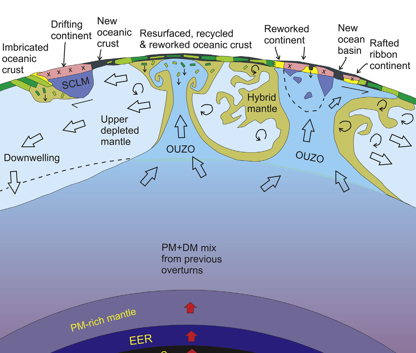
Geoscientists have become used to thinking of the Earth as being dominated by plate tectonics in which large, rigid plates of lithosphere move across the surface. They are driven mainly by the sinking of cold, densified lithosphere in slabs at subduction zones. The volume of recycled slabs is replaced by continual supply of mafic magma to form oceanic crust at constructive margins. Such a process has long been considered to have reached far back into the Precambrian past and there are lively debates concerning when this modusoperandi first arose and what preceded it. Now that we know more about other rocky planets and moons it appears that Earth is the only one on which plate tectonics has occurred. The other, more common, behaviour is dominated by stagnancy, although some worlds evidence volcanism and resurfacing as a result of giant impacts. Their subdued activity has come to be known as ‘lid tectonics’, in which their highly viscous innards slowly convect beneath a rigid, stagnant lid through which thermal energy is lost by convection: they are ‘one-plate’ systems. Although Earth loses internal heat by conduction through plate interiors, a large amount dissipates by convection associated with constructive margins: the oceanic parts of its plates lose heat laterally, as they grow older. Six papers in an advance, online issue of the free-access journal Geoscience Frontiers are concerned with the issue of terrestrial lid-tectonics and whether or not it dominated the Earth repeatedly in its Precambrian history.
A model is emerging for a hot, early Earth that was dominated by a form of lid tectonics (Bédard, J.H. 2018 Stagnant lids and mantle overturns: implications for Archaean tectonics, magmagenesis, crustal growth, mantle evolution, and the start of plate tectonics. Geoscience Frontiers, v. 9, 19-49; https://doi.org/10.1016/j.gsf.2017.01.005). Bedard’s model centres on lithosphere that was so weak because of its temperature that its subduction was impossible. Density of the lithosphere rarely increased above that of the mantle because the necessary mineralogical changes were not achieved – those involved in plate tectonics require low-temperature, high-pressure metamorphism as oceanic lithosphere is driven down at modern subduction zones. Even if such reactions did happen, the lithosphere would have been too weak to sustain slab-pull force and dense lithosphere would have simply ‘dripped’ back to the mantle. Mantle convection in a hotter Earth would have been in the form of large, long-lived upwelling zones rather than the relatively ephemeral and narrow plumes known today. Low density materials resulting from magma fractionation, the precursors of continental crust, would have been shifted willy-nilly across the face of the planet to collide. accrete and undergo repeated partial melting. In Bedard’s view, plate tectonics arose as Earth’s heat production waned below a threshold that permitted rigid lithosphere, probably in the late Archaean, to dominate after 2.5 Ga.
Bédard’s impression of an early Archaean lid-tectonic scenario. (credit: Jean H Bédard 2018, Figure 3B)
A radically different view is that stagnant-lid episodes alternated with periods of limited subduction and plate tectonics in the Archaean. Some Archaean cratons – the so-called ‘granite-greenstone terrains – seems to provide geological evidence for lid tectonics (Wyman, D. 2018. Do cratons preserve evidence of stagnant lid tectonics? Geoscience Frontiers, v. 9, 19-49; https://dx.doi.org/10.1016/j.gsf.2017.02.001). Others, such as the famous Isua supracrustal belt in West Greenland hint at plate tectonics. John Piper, of Liverpool University in Britain, argues from a series of Archaean palaeomagnetic polar wander curves that in three periods – ~2650 to 2200 Ma, 1550 to 1250 Ma, and 800 to 600 Ma – the poles shifted comparatively slowly with respect to the cratons providing the magnetic data; a feature that Piper ascribes to dominant lid tectonics (Piper, J.D.A., 2018. Dominant Lid Tectonics behaviour of continental lithosphere in Precambrian Times: palaeomagnetism confirms prolonged quasi-integrity and absence of Supercontinent Cycles. Geoscience Frontiers, v. 9, p. 61-89; https://doi.org/10.1016/j.gsf.2017.07.009). Similarly, there is some evidence based on the geochemical variation of basaltic rocks derived from the mantle. Through the Archaean, geochemical changes roughly follow cycles in the abundance of zircon radiometric ages and other geological changes that may reflect plate- and lid-tectonic episodes (Condie, K.C. 2018. A planet in transition: the onset of plate tectonics on Earth between 3 and 2 Ga? Geoscience Frontiers, v. 9, p. 51-60; https://doi.org/10.1016/j.gsf.2016.09.001). Interestingly, the age-frequency plot of almost three thousand Archaean and Hadean zircons recovered from the famous 1.6 Ga old sandstones of the Jack Hills Formation in Western Australia reveals similar cycles that may reflect such tectonic fluctuations in the Hadean (Wang, Q. & Wilde, S.A. 2017. New constraints on the Hadean to Proterozoic history of the Jack Hills belt,Western Australia. Gondwana Research, v. 55, p. 74-91; https://doi.org/10.1016/j.gr.2017.11.008). Since zircons are most likely to crystallize from intermediate and felsic magmas – i.e. precursors of continental material – their abundance in the Jack Hills rocks suggests that their source must have been in the 3.7 to 3.3 Ga gneisses on which the younger sediments rest. That is, part of those Archaean gneisses may well be made up of Hadean continental material that was repeatedly reworked and maybe remelted since such crust first appeared (in the form of surviving zircons) around 4.4 to 4.5 Ga, perhaps during vigorous lid-tectonic regimes.
Possible evolution of magmatic and tectonic styles for large silicate planets. (Credit: Stern et al. 2018, Figure 3)
Based on their reassessment of tectonic activity revealed by 8 rocky planets and moons Robert Stern of the University of Texas (Dallas) and colleagues from ETH-Zurich suggest a possible evolutionary sequence of tectonics and magmatism that Earth-like bodies might go through (Stern, R.J. et al. 2018. Stagnant lid tectonics: Perspectives from silicate planets, dwarf planets, large moons, and large asteroids. Geoscience Frontiers, v. 9, p. 103-119 ; https://doi.org/10.1016/j.gsf.2017.06.004). In their scheme plate tectonics requires certain conditions of lithospheric density and strength to evolve and suggest that, depending on planetary characteristics, slab-pull driven tectonics is likely to be preceded and followed by stagnant lid tectonics, to give perhaps a cyclical geotectonic history.
A fully revised edition of Steve Drury’s book Stepping Stones: The Making of Our Home World can now be downloaded as a free eBook
You and I, and all the living things that we can easily see belong to the most recently evolved of the three great domains of life, the Eukarya. The vast bulk of organisms that we can’t see unaided are prokaryotes, divided into the Bacteria and the Archaea. Their genetic material floats around in their cell’s fluid, while ours resides mainly in the eukaryote cell’s nucleus with a bit in various organelles known as mitochondria and the chloroplasts of plant cells. Unlike the chicken and egg question, that concerning which came first, prokaryotes or eukaryotes, is answered by DNA. Eukaryote DNA contains a lot from prokaryotes, but the converse does not hold. That contrast posed the question of how eukaryotes arose from the two earlier, simpler forms of life, the answer to which Lynn Margulis suggested to be a whole series of symbiotic relationships among various prokaryotes that shared a host cell; her hypothesis of endosymbiosis. Now, the vast majority of eukaryotes depend on free oxygen for their metabolism, so when the first of them arose boils down to the period of geological history following the Great Oxidation Event around 2.4 billion years ago.
Structure of a typical eukaryote (animal) cell (credit: Wikipedia)
Molecular-clock estimates based on the range of variation in the genomes of a wide range of eukaryotes suggest it took place sometime between 1000 and 2000 Ma. A better means of homing in on a date for the Last Eukaryote Common Ancestor (LECA – as opposed to that of the first organism LUCA) would be that of the earliest fossil to show eukaryote affinities. Grypania from 1.85 Ga, a sort of whorl-like fossil, is a good candidate and is widely thought to be the earliest of our kind but lacks signs of actual cells. More convincing fossils – known generically as acritarchs – from times between 1.5 and 1.0 Ga look like primitive fungi, red algae and slime moulds. A comprehensive review of the microfossils of the Palaeoproterozoic (2.5 to 1.6 Ga) includes both prokaryotes and probable early eukaryotes (Javaux, E.J. & Lepot, K. 2017. The Paleoproterozoic fossil record: Implications for the evolution of the biosphere during Earth’s middle-age. Earth Science Reviews, v. 176, p. 68-86; doi: 10.1016/j.earscirev.2017.10.0001). Yet, despite rapidly accumulating evidence, especially from rocks in China, the picture remains one of monotony; for instance Grypania spans the best part of half a billion years. Bacteria and Archaea cannot be distinguished easily in the absence of preserved DNA. Despite evidence for oxygen in the oceans and atmosphere, apart from a few shallow-water oxygenated examples the chemistry of Palaeoproterozoic marine sediments is dominated by mineralogical outcomes of reducing chemistry. Many chemical isotopic environmental proxies ‘flat-line’ to the extent that the early Proterozoic is sometimes referred to as the ‘boring billion’, yet our ultimate precursors were part of the marine ecosystem. That is, unless one accepts the possibility that that fossils labelled ‘eukaryote’ are colonial prokaryotes – evidence for cell nuclei is sparse. Endosymbiosis, although an attractive model for eukaryote origins, is not proven. The reason for lingering scepticism is that there are only a tiny number of modern examples of prokaryote cells ending up inside those of other prokaryotes.
Whatever, chemical biomarkers in sediments older than about 720 Ma indicate that prokaryotes were the only notable primary producers in the oceans until the Neoproterozoic. Microscopic fossils that are inescapably eukaryotes in the form of amoeba suddenly emerge around that time. This development from the lingering marginality of early eukaryotes to thriving ecosystems that they dominated thereafter is a puzzle seeking a plausible explanation. It coincides with the onset of the Snowball Earth glaciations of the Cryogenian Period (850 to 635 Ma) and a rise in atmospheric and presumably oceanic oxygen. Then macroscopic eukaryotes ‘bloomed’ into distinctively different forms in the Ediacaran Period (635 to 541 Ma) and thereafter. Before the Cryogenian we can perhaps regard eukaryan life and the endosymbiosis that may have given rise to it as a series of ecological experiments repeatedly knocked-back by chemical conditions and competition with the vastly more abundant prokaryotes.
During most of the last hundred years every car body, rebar rod in concrete, ship, bridge and skyscraper frame had its origins in vividly striped red rocks from vast open-pit mines. Comprising mainly iron oxides with some silica, these banded iron formations, or BIFs for short, occur in profitable tonnages on every continent.
2.1 billion years old boulder of banded ironstone. (credit: Wikipedia)
Because they are fast as well as weighty, destination-Earth asteroids and comets pack quite a punch. That is because their kinetic energy is proportional to the square of their speed (at least 13 km s-1) as well as half their mass. So, even all one half a kilometre across carries an energy a hundred times the solar energy received by Earth in a year, and a great deal more when compared with geothermal heat production. Much of the focus on the effects of impact events has dwelled on the upper crust, the oceans and atmosphere. Yet they also have huge seismic effects, with a proportion of their shock effect being dissipated throughout the entire planet. One obvious consequence would be a thermal anomaly directly beneath the crater as well as some thinning of the lithosphere and body waves affecting the rest of the solid Earth.
Thermal and mechanical processes lie at the core of tectonics, so a big question has been ‘Could impacts create mantle plumes or set new tectonic processes in motion?’ There has been speculation of diverse kinds since impacts became popular following the link between the Chicxulub crater and the end-Cretaceous mass extinction, discovered in 1980. But ‘educated guesses’ have generated more hot air than clear conclusions. Much as most of us are modelling-averse, a mathematical approach is the only option in the welcome absence of any severe extraterrestrial battering to which scientists have borne witness. With refined algorithms that cover most of the nuances of projectiles and targets – conservation of mass, energy and momentum in the context of the solid Earth behaving as a viscous medium – Craig O’Neill and colleagues at Macquairie University, Australia, and the Southwest Research Centre in Boulder, CO USA, have simulated possible tectonic outcomes during plausible bombardment scenarios during the Hadean (O’Neil, C. et al. 2017. Impact-driven subduction on the Hadean Earth. Nature Geoscience, v. 10, p. 793-797; DOI: 10.1038/NGEO3029).
It appears that truly gargantuan objects – radius >500 km – are required to stimulate sufficient thermal anomalies that would lead to mantle upwellings whose evolution might lead to subduction at their margins. One at the limit posed by lunar cratering history (~1700 km radius) could have resulted in wholesale subduction of the entire lithosphere present at the time about 4 Ma after the impact. In the Hadean, it is likely that the lithosphere would have had a roughly mantle composition, so that the density excess needed for slab descent would have been merely temperature dependent. Note: after the onset of a basalt-capped lithosphere heat flow would have needed to be below the limit at which basalt converts to eclogite at high pressures, and thus to a density greater than that of the mantle, for continuing subduction. The authors’ Hadean scenario is one of episodic subduction dependent on the projectile flux and magnitude; i.e. with an early Hadean with stop-start subduction waning to tectonic stagnation and then a restart during the Late Heavy Bombardment after 4.1 Ga. Evidence for this is clearly scanty, except for Hadean zircons, whose presence indicates differentiation of early magmas with a peak between 4.0 to 4.2 Ga, in which magnetic intensities are preserved that are roughly as predicted by the scenario.
No impacts preserved in Precambrian to Recent times suggest extraterrestrial objects with the power to induce significant changes to global tectonics.
Because continental crust is so light – an average density of 2700 kg m-3 compared with the mantles’ value of 3300 – it has been widely believed that continents cannot be subducted en masse. Yet it is conceivable that sial can be ‘shaved’ from below during subduction and from above by erosion and added to subductable sediment on the ocean floor. Certainly, there is overwhelming evidence for the net growth of continents through time and plenty for periods of increased and dwindling growth in the past. In some ancient orogens there are substantial slabs of continental composition whose mineralogy bears witness to ultra-high pressure metamorphism at depths greater than that of the base of continents. These slabs had been caught-up in subduction but never reached sufficiently high density to be retained by the mantle; they eventually ‘bobbed up’ again. On the other hand, if early continents were less silica rich through incorporation of substantial proportions of rock with basaltic composition parts of them could founder if subjected to high-pressure, low-temperature metamorphism. But not all crustal recycling to the mantle is through subduction. Some abnormally highly elevated parts of the continents that rose quickly in geological terms, such as the Tibetan Plateau, may have formed by lower crustal slabs becoming detached or delaminated from their base. Again modelling can help assess the past magnitude of continental recycling (Chowdhury, P. et al. 2017. Emergence of silicic continents as the lower crust peels off on a hot plate-tectonic Earth. Nature Geoscience, v. 10, p. 698-703; DOI: 10.1038/NGEO3010).
Various lines of evidence suggest that between 65 to 70% of the present continental volume existed by 3 billion years ago, yet that does not manifest itself in the rock record; perhaps a sign that some has returned to the mantle. It is also widely suggested that plate tectonics in the modern style began at about that time. Pryadarshi Chowdhury and colleagues simulate what may happen at depth in continent-continent collision zones – the classic site of orogenies –at different times in the past. Under the hotter conditions in the early Archaean mantle delamination would have been more likely than it has been during the Phanerozoic; i.e. the peeling off and sinking of the denser, more mafic lower crust and the attached upper mantle. The authors show that increased mantle temperature further back in time increases the likelihood and extent of such delamination. It also encourages partial melting of the descending continental material so creating rising bodies of more silicic magma that add to the remaining continent at the surface. Together with the lower crust’s attachment of to a mantle slab, this ensures that the peeled off material is able to descend under its own load. Once below a depth of 250 km felsic rocks are doomed to further descent. Waning of radiogenic mantle heat production encourages descending slabs to fail and break from the connection with lithosphere at higher levels so that a smaller proportion of the lower crust becomes detached and recycled. This evolution suggests that less and less continental crust is recycled with time. This broadly fits with current geochemical ideas based on the record of radiogenic Nd-, Sr- and Pb-isotopes in rocks ranging from early Archaean to Phanerozoic age.
Geoscientists have become used to the idea that long-term global climate shifts are cyclical, as predicted by Milutin Milanković. The periods of shifts in the Earth’s orbital and rotational parameters are of the order of tens to hundreds of thousand years. The gravitational reasons why they occur have been known since the 1920s when Milanković came up with his hypothesis, and they were confirmed fifty years later. But there are plenty of other cycles with shorter periods. The last 115 years of worldwide records for earthquakes with magnitudes greater than 7 whose changing annual frequency shows a clear cyclical period of about 32 years. The records show peaks in 1910, 1943, 1970 and 2011 (see Bendick, R. & Bilham, R. 1917. Do weak global stresses synchronize earthquakes? Geophysical Research Letters, v. 44 online; doi/10.1002/2017GL074934). Unlike Milanković cycles, these oscillations were not predicted, but something synchronous with them must be forcing this behavior: a sort of “cross-talk”. Either global seismicity has a tendency for events to trigger others elsewhere on the Earth or some other process is periodically engaging with major brittle deformation to give it a nudge.
Rebecca Bendick, of the University of Montana, Missoula, and Roger Bilham of the University of Colorado, Boulder used a complex statistical method to check for synchronicity between the seismic cycles and other repetitive phenomena. It turns out that there is a close match with historic data for the length of the day which varies by several milliseconds. At first sight this may seem odd, until one realizes that day length is governed by the Earth’s speed of rotation (about 460 m s-1 at the Equator). The correlation is between increases in both major seismicity and the length of the day; i.e. quakes increase as rotation slows. Day length can vary by a millisecond over a year or so during el Niño, which involves shifts of vast masses of Pacific Ocean water that affect rotation. But what of larger changes on a three-decade cycle? Seismic events and the forces that they release result from buildup of strain in the lithosphere, so the episodic earthquake maxima require some kind of transfer of momentum within the Earth. It does not need to be large, as the Milanković astronomical forcing of climate demonstrates, just a regular pulse.
One possibility is that, as rotation decelerates, decoupling between the liquid outer core and the solid mantle may change the flow of molten iron-nickel alloy. That may be sufficient to transmit momentum and thus stress through the plastic mantle to the brittle lithosphere so that areas of high elastic strain are pushed beyond the rocks’ strength so that they fail. There are indeed signs that the geomagnetic field also changes with day length on a decadal basis (Voosen, P. 2017. Sloshing of Earth’s core may spike big quakes. Science, v. 358, p. 575; doi:10.1126/science.358.6363.575). Rotational deceleration began in 2011, and if the last century’s trend holds there may be an extra five large earthquakes next year. Could the deadly 7.3 magnitude earthquake at the Iran-Iraq border on 12 November 2017 be the start? If so, will the 32-year connection improve currently unreliable earthquake forecasting? Probably the best we can expect is increased global readiness. The study has nothing to add as regards which areas are at risk: although there is clustering in time there is none with location, even on the regional scale.
A fully revised edition of Steve Drury’s book Stepping Stones: The Making of Our Home World can now be downloaded as a free eBook
Iranians salvage their furniture and household appliances from damaged buildings in the town of Sarpol-e Zahab in Iran’s western Kermanshah province near the border with Iraq, on November 14, 2017
Under the auspices of the International Ocean Discovery Program (IODP), during April and May 2016 a large team of scientists and engineers sank a 1.3 km deep drill hole into the offshore, central part of the Chicxulub impact crater, which coincided with the K-Pg mass extinction event. Over the last year work has been underway to analyse the core samples aimed at investigating every aspect of the impact and its effects. Most of the data is yet to emerge, but the team has published the results of advanced modelling of the amount of climate-affecting gases and dusts that may have been ejected (Artemieva, N. et al. 2017. Quantifying the release of climate-active gases by large meteorite imp-acts with a case study of Chicxulub. Geophysical Research Letters, v. 44; DOI: 10.1002/2017GL074879). . From petroleum exploration in the Gulf of Mexico the impact site is known to have been underlain by about 2.5 to 3.5 km of Mesozoic sediments that include substantial amounts of limestones and evaporitic anhydrite (CaSO4) – thicknesses of each are of the order of a kilometre. The impact would inevitably have yielded huge volumes of carbon- and sulfur dioxide gases, as well as water vapour plus solid and molten ejecta. The first, of course, is a critical greenhouse gas, whereas SO2 would form sulfuric acid aerosols if it entered the stratosphere. They are known to block incoming solar radiation. So both warming and cooling influences would have been initiated by the impact. Dust-sized ejecta that lingered in the atmosphere would also have had climatic cooling effects. The questions that the study aimed to answer concerns the relative masses of each gas that would have reached more than 25 km above the Earth to have long-term, global climatic effects and whether the dominant effect on climate was warming or cooling. Both gases would have added the environmental effects of making seawater more acid.
3-D simulation of the Chicxulub crater based on gravity data (credit: Wikipedia)
Such estimates depend on a large number of factors beyond the potential mass of carbonate and sulfate source rocks. For instance: how big the asteroid was; how fast it was travelling and the angle at which it struck the Earth’s surface determine the kinetic energy involved and the impact mechanism. How that energy was distributed between atmosphere, seawater and the sedimentary sequence, together with the pressure-temperature conditions for the dissociation of calcite and anhydrite all need to be accounted for by modelling. Moreover, the computation itself becomes extremely long beyond estimates for the first second or so of the impact. Earlier estimates had been limited by computer speeds to only the first few seconds of the impact and could not allow for other than vertical impacts. The new study, by supercomputers and improved algorithms, used a likely 60° angle of impact, new data on mineral decomposition and simulated the first 15 to 30 seconds. The results suggested that 325 ± 130 Gt of sulfur and 425 ± 160 Gt CO2 were ejected, compared with earlier estimates of 40-560 Gt of sulfur and 350-3,500 Gt of CO2. The greater proportion of sulfur release to the stratosphere pushes the model decisively towards global cooling, probably over a lengthy period – perhaps centuries. Taking dusts into account implies that visible sunlight would also have been blocked, devastating the photosynthetic base of the global food chain, in the sunlit parts of oceans as well as on land.
But we have to remember that these are the results of a theoretical model. In the same manner as this study has thrown earlier modeling into doubt, more data – and there will be a great many from the Chicxulub drill core itself – and more sophisticated computations may change the story significantly. Also, the other candidate for the mass extinction event, the flood basalt volcanism of the Deccan Traps, and its geochemical effects on the climate have yet to be factored in. The next few lines of Shakespeare’s soliloquy for Richard III may well emerge from future work
… Made glorious summer by this sun of York;
And all the clouds that lour’d upon our house
In the deep bosom of the ocean buried …