How changes in the Earth System have affected human evolution, migration and culture

Refugees from the Middle East migrating through Slovenia in 2015. Credit: Britannica

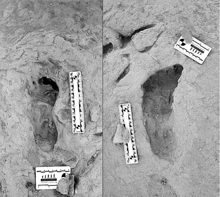
During the Pliocene (5.3 to 2.7 Ma) there evolved a network of various hominins, with their remains scattered across both the northern and southern parts of that continent. The earliest, though somewhat disputed hominin fossil Sahelanthropus tchadensis hails from northern Chad and lived  around 7 Ma ago, during the late Miocene, as did a similarly disputed creature from Kenya Orrorin tugenensis (~5.8 Ma). The two were geographically separated by 1500 km, what is now the Sahara desert and the East African Rift System.  The suggestion from mtDNA evidence that humans and chimpanzees had a common ancestor, the uncertainty about when it lived (between 13 to 5 Ma) and what it may have looked like, let alone where it lived, makes the notion debateable. There is even a possibility that the common ancestor of humans and the other anthropoid apes may have been European. Its descendants could well have crossed to North Africa when the Mediterranean Sea had been evaporated away to form the thick salt deposits that now lie beneath it: what could be termed the ‘Into Africa’ hypothesis. The better known Pliocene hominins were also widely distributed in the east and south of the African continent. Wandering around was clearly a hominin predilection from their outset. The same can be said about humans in the general sense (genus Homo) during the Early Pleistocene when some of them left Africa for Eurasia. Artifacts dated at 2.1 Ma have been found on the Loess Plateau of western China, and Georgia hosts the earliest human remains known from Eurasia. Since them H. antecessor, heidelbergensis, Neanderthals and Denisovans roamed Eurasia. Then, after about 130 ka, anatomically modern humans progressively populated all continents, except Antarctica, to their geographic extremities and from sea level to 4 km above it.

There is a popular view that curiosity and exploration are endemic and perhaps unique to the human line: ‘It’s in our genes’. But even plants migrate, as do all animal species. So it is best to be wary of a kind of hominin exceptionalism or superior motive force. Before settled agriculture, simply diffusion of populations in search of sustenance could have achieved the enormous migrations undertaken by all hominins: biological resources move and hunter gatherers follow them. The first migration of Homo erectus from Africa to northern China by way of Georgia seems to taken 200 ka at most and covered about ten thousand kilometres: on average a speed of only 50 m per year! That achievement and many others before and later were interwoven with the evolution of brain size, cognitive ability, means of communication and culture. But what were the ultimate drivers? Two recent papers in the journal Nature Communications make empirically-based cases for natural forces driving the movement of people and changes in demography.

The first considers hominin dispersal in the Palaearctic biogeographic realm: the largest of eight originally proposed by Alfred Russel Wallace in the late 19th century that encompasses the whole of Eurasia and North Africa (Zan, J. et al. 2024. Mid-Pleistocene aridity and landscape shifts promoted Palearctic hominin dispersals. Nature Communications, v. 15, article 10279; DOI: 10.1038/s41467-024-54767-0). The Palearctic comprises a wide range of ecosystems: arid to wet, tropical to arctic. After 2 Ma ago, hominins moved to all its parts several times. The approach followed by Zan et al. is to assess the 3.6 Ma record of the thick deposits of dust carried by the perpetual westerly winds that cross Central Asia. This gave rise to the huge (635,000 km2) Loess Plateau. At least 17 separate soil layers in the loess have yielded artefacts during the last 2.1 Ma. The authors radiocarbon dated the successive layers of loess in Tajikistan (286 samples) and the Tarim Basin (244 samples) as precisely as possible, achieving time resolutions of 5 to 10 ka and 10 to 20 ka respectively. To judge variations in climate in these area they also measured the carbon isotopic proportions in organic materials preserved within the layers. Another climate-linked metric that Zan et al. is a time series showing the development of river terraces across Eurasia derived from the earlier work of many geomorphologists. The results from those studies are linked to variations through time in the numbers of archaeological sites across Eurasia that have yielded hominin fossils, stone tools and signs of tool manufacture, many of which have been dated accurately.

The authors use sophisticated statistics to find correlations between times of climatic change and the signs of hominin occupation. Episodes of desertification in Palaearctic Eurasia clearly hindered hominins’ spreading across the continent either from west to east of vice versa. But there were distinct, periodic windows of climatic opportunity for that to happen that coincide with interglacial episodes, whose frequency changed at the Mid Pleistocene Transition (MPT) from about 41 ka to roughly every 100 ka. That was suggested in 2021 to have arisen from an increased roughness of the rock surface over which the great ice sheets of the Northern Hemisphere moved. This suppressed the pace of ice movement so that the 41 ka changes in the tilt of the Earth’s rotational axis could no longer drive climate change during the later Pleistocene, despite the fact that the same astronomical influence continued. The succeeding ~100 ka pulsation may or may not have been paced by the very much weaker influence of Earth changing orbital eccentricity. Whichever, after the MPT climate changes became much more extreme, making human dispersal in the Palearctic realm more problematic. Rather than hominin’s evolution driving them to a ‘Manifest Destiny’ of dominating the world vastly larger and wider inorganic forces corralled and released them so that, eventually, they did.

Much the same conclusion, it seems to me, emerges from a second study that covers the period since ~ 9 ka ago when anatomically modern humans transitioned from a globally dominant hunter-gatherer culture to one of ‘managing’ and dominating ecosystems, physical resources and ultimately the planet itself. (Wirtz, K.W et al. 2024. Multicentennial cycles in continental demography synchronous with solar activity and climate stability. Nature Communications, v. 15, article 10248; DOI: 10.1038/s41467-024-54474-w). Like Zan et al., Kai Wirtz and colleagues from Germany, Ukraine and Ireland base their findings on a vast accumulated number (~180,000) of radiocarbon dates from Holocene archaeological sites from all inhabited continents. The greatest number (>90,000) are from Europe. The authors applied statistical methods to judge human population variations since 11.7 ka in each continental area. Known sites are probably significantly outweighed by signs of human presence that remain hidden, and the diligence of surveys varies from country to country and continent to continent: Britain, the Netherlands and Southern Scandinavia are by far the best surveyed. Given those caveats, clearly this approach gives only a blurred estimate of population dynamics during the Holocene. Nonetheless the data are very interesting.

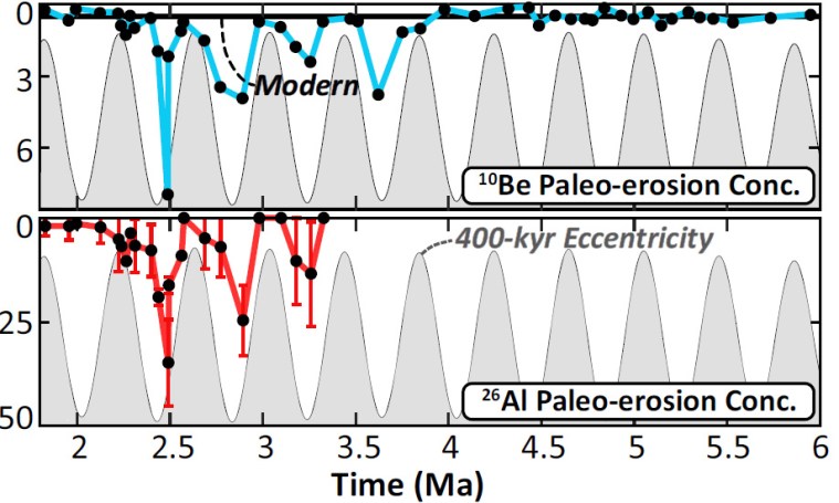
The changes in population growth rates show distinct cyclicity during the Holocene, which Wirtz et al. suggest are signs of booms and busts in population on all six continents. Matching these records against a large number of climatic time series reveals a correlation. Their chosen metric is variation in solar irradiance: the power per unit area received from the Sun. That has been directly monitored only over a couple of centuries. But ice cores and tree rings contain proxies for solar irradiance in the proportions of the radioactive isotopes 10Be and 14C contained in them respectively. Both are produced by the solar wind of high-energy charged particles (electrons, protons and helium nuclei or alpha particles) penetrating the upper atmosphere. The two isotopes have half-lives long enough for them to remain undecayed and thus detectable for tens of thousand years. Both ice cores and tree rings have decadal to annual time resolutions. Wirtz et al. find that their crude estimates of booms and busts in human populations during the Holocene seem closely to match variations in solar activity measured in this way. Climate stability favours successful subsistence and thus growth in populations. Variable climatic conditions seem to induce subsistence failures and increase mortality, probably through malnutrition.

A nice dialectic clearly emerges from these studies. ‘Boom and bust’ as regards populations in millennial and centennial to decadal terms stem from climate variations. Such cyclical change thus repeatedly hones natural selection among the survivors, both genetically and culturally, increasing their general fitness to their surroundings. Karl Marx and Friedrich Engels would have devoured these data avidly had they emerged in the 19th century. I’m sure they would have suggested from the evidence that something could go badly wrong – negation of negation, if readers care to explore that dialectical law further . . . And indeed that is happening. Humans made ecologically very fit indeed in surviving natural pressures are now stoking up a major climatic hiccup, or rather the culture and institutions that humans have evolved are doing that.

Hominin footprints in Kenya confirm two species occupied the same ecosystem the same time

For the last forty thousand years anatomically modern humans have been the only primates living on Planet Earth with a sophisticated culture; i.e. using tools, fire, language, art etcetera. Since Homo sapiens emerged some 300 ka ago, they joined at least two other groups of humans – Neanderthals and Denisovans – and not only shared Eurasia with them, but interbred as well. In fact no hominin group has been truly alone since Pliocene times, which began 5.3 Ma ago. Sometimes up to half a dozen species occupied the habitable areas of Africa. Yet we can never be sure whether or not they bumped into one another. Dates for fossils are generally imprecise; give or take a few thousand years. The evidence is merely that sedimentary strata of roughly the same age in various places have yielded fossils of several hominins, but that co-occupation has never been proved in a single stratum in the same place: until now.

Footprints from Koobi Fora: left – right foot of H. erectus; right – left foot of Paranthropus boisei. Credit: Kevin Hatala. Chatham University

The Koobi Fora area near modern Lake Turkana has been an important, go-to site, courtesy of the Leakey palaeoanthropology dynasty (Louis and Mary, their son and daughter-in-law Richard and Meave, and granddaughter Louise). They discovered five hominin species there dating from 4.2 to 1.4 Ma. So there was a chance that this rich area might prove that two of the species were close neighbours in both space and time. In 2021 Kenyan members of the Turkana Basin Institute based in Nairobi spotted a trackway of human footprints on a bedding surface of sediments that had been deposited about 1.5 Ma ago. Reminiscent of the famous, 2 million years older Laetoli trackway of Australopithecus afarensis in Tanzania, that at Koobi Fora is scientifically just as exciting  for it shows footprints of two hominin species Homo erectus and Paranthropus boisei who had walked through wet mud a few centimetres below the surface of Lake Turkana’s ancient predecessor (Hatala, K.G. and 13 others, 2024. Footprint evidence for locomotive diversity and shared habitats among early Pleistocene hominins. Science, v. 386, p. 1004-1010; DOI: 10.1126/science.ado5275). The trackway is littered with the footprints of large birds and contains evidence of zebra.

One set of prints attributed to H. erectus suggest the heels struck the surface first, then the feet rolled forwards before pushing off with the soles: little different from our own, unshod footprints in mud. They are attributed to H. erectus. The others also show a bipedal gait, but different locomotion. The feet that made them were significantly flatter than ours and had a big toe angled away from the smaller toes. They are so different that no close human relative could have made them. The local fossil record includes paranthropoids (Paranthropus boisei), whose fossil foot bones suggest an individual of that speciesmade those prints. It also turns out that a similar, dual walkers’ pattern was found 40 km away in lake sediments of roughly the same age. The two species cohabited the same terrain for a substantial period of time. As regards the Koobi Fora trackway, it seems the two hominins plodded through the mud only a few hours apart at most: they were neighbours.

Artists’ reconstructions of: left – H. erectus; right – Paranthropus boisei. Credits: Yale University, Roman Yevseyev respectively

From their respective anatomies they were very different. Homo erectus was, apart from having massive brow ridges, similar to us. Paranthropus boisei had huge jaws and facial muscles attached to a bony skull crest. So how did they get along? The first was probably omnivorous and actively hunted or scavenged meaty prey: a bifacial axe-wielding hunter-gatherer. Paranthropoids seem to have sought and eaten only vegetable victuals, and some sites preserve bone digging sticks. They were not in competition for foodstuffs and there was no reason for mutual intolerance. Yet they were physically so different that intimate social relations were pretty unlikely. Also their brain sizes were very different, that of P. Boisei’s being far smaller than that of H. erectus , which may not have encouraged intellectual discourse. Both persist in the fossil record for a million years or more. Modern humans, Neanderthals and Denisovans, as we know, sometimes got along swimmingly, possibly because they were cognitively very similar and not so different physically.

Since many hominin fossils are associated with riverine and lake-side environments, it is surprising that more trackways than those of Laetoli and Koobi Fora have been found. Perhaps that is because palaeoanthropologists are generally bent on finding bones and tools! Yet trackways show in a very graphic way how animals behave and interrelate with their environment, for example dinosaurs. Now anthropologists have learned how to spot footprint trace fossils that will change, and enrich the human story.

See also: Ashworth, J. Fossil footprints of different ancient humans found together for the first time. Natural History Museum News 28 November 2024; Marshall, M. Ancient footprints show how early human species lived side by side. New Scientist, 28 November 2024

Who invented stone tools? A great surprise from Kenya

Up to now the earliest stone tools are objects dated to about 3.3 Ma (Late Pliocene) found in the Turkana basin of Kenya in 2015. They are sharp-edged pieces of rock that seem to have been made simply by striking two lumps of rock together (see: Stone tools go even further back; May 2015). These Lomekwian artefacts are similar to the basic tools made today by some chimpanzees in parts of Africa. Their age matches that for the earliest known animal bones that show signs of having meat cut from them, which were unearthed in Dikika, Ethiopia (see: Another big surprise; September 2010) which, like the Lomekwian tools, are not accompanied by tools or hominin remains. The earliest tools associated with members of the genus Homo are significantly more sophisticated. They were found in close association with H. habilis at what seems to have been a well-used butchering site, dated at 2.0 Ma, in Tanzania’s Olduvai Gorge, hence their designation as the Oldowan ‘industry’. The Oldowan ‘tool kit’ includes choppers and blades deliberately shaped to be wielded by hand and made by striking large cobbles with distinctive hammer stones. Earlier tools with this level of deliberate crafting come from the 2.6 Ma Ledi-Geraru site in the Afar Depression of NE Ethiopia but with no sign of their makers.

Oldowan tools used for pounding and cutting from Nyayanga, Kenya (Credit: Thomas Plummer, James Oliver and Emma Finestone/Homa Peninsula Paleoanthropology Project/SWNS)

The presence of Oldowan tools has now been pushed further back, by about 400 ka, thanks to excavations in Late Pliocene sediments at Nyayanga on the shore of Lake Victoria in western Kenya by Thomas Plummer of Queens College in New York State, USA, and his numerous collaborators from the US, Germany, the UK, China, Italy, Australia, Kenya, South Africa and Poland (Plummer, T.W. and 31 others 2023. Expanded geographic distribution and dietary strategies of the earliest Oldowan hominins and Paranthropus. Science, v. 379, p. 561-566; DOI: 10.1126/science.abo7452). Their work also expands the range of Oldowan culture by about 1300 km. The Nyayanga site yielded over 300 artefacts that closely resemble the previously known range of Oldowan tool shapes. Their makers struck flakes from suitable corestones – made of rhyolite, quartz and quartzite – and trimmed them by more intricate means. They seem to have been used to cut up mainly hippo and buffalo, bones of which bear clear cut marks, but had other uses. Analysis of the wear on tool surfaces not only show signs of butchery, but also processing of plant tissue by pounding; the latter resulted in pitting and polishing of tools that seem to have been used many times. Stable-isotope analysis of the bones and animal teeth suggests that in the Pliocene Nyayanga was a grassy and partly wooded savannah close to a substantial water body needed by hippos.

Reconstruction of a Paranthropus head (Credit: Jerry Humphrey, Pinterest)

The ‘great surprise’ is that the only hominin remains associated with the site are two damaged molar teeth. They are so large that their most likely source was a species of Paranthropus.Paranthropoids have long been considered to be a gorilla-like, ‘robust’ branch of australopithecines. Their large cranial crests anchoring jaw muscles and enormous teeth were reckoned to indicate a diet of tough vegetation – the discoverer of the first specimen of P. boisei dubbed it ‘Nutcracker Man’ – although the wear on individual teeth suggests otherwise. But there is no reason to suppose that they could not eat meat. They survived australopithecines by more than a million years to cohabit the East African savannahs with H. ergaster until about 1 Ma ago.

Lead author Thomas Plummer wonders if paranthropoids would have needed tools because they had the largest jaws and teeth of any hominin. But had his team found close association with smaller H.habilis teeth would he have held a similarly negative view? There is evidence from younger sites in South Africa that paranthropoids used a wide diversity of bone tools and may even have been among the earliest fire users. So why the negativity about stone tools? To paraphrase Ali G, ‘Is it because they is ugly?’

See also: Devlin, H, Discovery of 3m-year-old stone tools sparks prehistoric whodunit. The Guardian, 9 February 2023

Is erosion paced by Milankovich cycles?

Both physical and chemical weathering reflects climatic controls. Erosion is effectively climate in continuous action on the Earth’s solid surface through water, air and bodies of ice moving under the influence of gravity. These two major processes on the land surface are immensely complicated. Being the surface part of the rock cycle, they interact with biological processes in the continents’ web of climate-controlled ecosystems. It is self-evident that climate exerts a powerful influence on all terrestrial landforms. But at any place on the Earth’s surface climate changes on a whole spectrum of rates and time scales as reflected by palaeoclimatology. With little room for doubt, so too do weathering and erosion. Yet other forces are at play in the development of landforms. ‘Wearing-down’ of elevated areas removes part of the load that the lithosphere bears, so that the surface rises in deeply eroded terrains. Solids removed as sediments depress the lithosphere where they are deposited in great sedimentary basins. In both cases the lithosphere rises and falls to maintain isostatic balance. On the grandest of scales, plate tectonics operates continuously as well. Its lateral motions force up mountain belts and volcanic chains, and drag apart the lithosphere, events that in themselves change climate at regional levels. Tectonics thereby creates ‘blips’ in long term global climate change. So evidence for links between landform evolution and palaeoclimate is notoriously difficult to pin down, let alone analyse.

The evidence for climate change over the last few million years is astonishingly detailed; so much so that it is possible to detect major global events that took as little as a few decades, such as the Younger Dryas, especially using data from ice cores. The record from ocean-floor sediments is good for changes over hundreds to thousands of years. The triumph of palaeoclimatology is that the last 2.5 Ma of Earth’s history has been proved to have been largely paced by variations in the Earth’s orbit and in the angle of tilt and wobbles of its rotational axis: a topic that Earth-logs has tracked since the start of the 21st century. The record also hints at processes influencing global climate that stem from various processes in the Earth system itself, at irregular but roughly millennial scales. The same cannot be said for the geological record of erosion, for a variety of reasons, foremost being that erosion and sediment transport are rarely continuous in any one place and it is more difficult to date the sedimentary products of erosion than ice cores and laminations in ocean-floor sediments. Nonetheless, a team from the US, Germany, the Netherlands , France and Argentina have tackled this thorny issue on the eastern side of the Andes in Argentina (Fisher, G.B. and 11 others 2023. Milankovitch-paced erosion in the southern Central Andes. Nature Communications, v. 14, 424-439; DOI: 10.1038/s41467-023-36022-0.

Burch Fisher (University of Texas at Austin, USA) and colleagues studied sediments derived from a catchment that drains the Puna Plateau that together with the Altiplano forms the axis of the Central Andes. In the late 19th century the upper reaches of the Rio Iruya were rerouted, which has resulted in its cutting a 100 m deep canyon through Pliocene to Early Pleistocene (6.0 to 1.8 Ma) sediments. The section includes six volcanic ash beds (dated precisely using the zircon U-Pb method) and records nine palaeomagnetic reversals, which together helped to calibrate more closely spaced dating. Their detailed survey used the decay of radioactive isotopes of beryllium and aluminium (10Be and 26Al) in quartz grains that form in the mineral when exposed at the surface to cosmic-ray bombardment. Such cosmogenic radionuclide dating thus records the last time different sediment levels were at the surface, presumably when the sediment was buried, and thus the variation in the rate of sediment supply from erosion of the Rio Iruya catchment since 6 Ma ago.

Measured concentrations (low to high values downwards) of cosmogenic 10Be (turquoise) and 26Al (red) in samples from the Rio Iruya sediment sequence. The higher the value, the longer the layer had resided at the surface; i.e. the slower the erosion rate. (Credit: Fisher et al. Fig 4)

The data from 10Be suggest that erosion rates were consistently high from 6 to 4 Ma, but four times during the later Pliocene and the earliest Pleistocene they slowed dramatically. Each of these episodes occupies downturns in solar warming forced by the 400 ka cycle of orbital eccentricity. The 26Al record confirms this trend. The most likely reason for the slowing of erosion is long-term reductions in rainfall, which Fisher et al have modelled based on Milankovich cycles. However the modelled fluctuations are subtle, suggesting that in the Central Andes at least erosion rates were highly sensitive to climatic fluctuations. Yet the last 400 ka cycle in the record shows no apparent correlation with climate change.  Despite that, astronomical forcing while early Pleistocene oscillations between cooling and warming ramped up does seem to have affected erosion rates based on the cosmogenic dating. The authors attribute this loss of the 400 ka pattern to a kind of swamping effect of dramatically increased erosion rates as the regional climate became more erratic. Whether or not data of this kind will emerge for the more climatically drastic 100 ka cyclicity of the last million years remains to be seen … Anyone who has walked over terrains covered in glacial tills and glaciofluvial gravel beds nearer to the former Late Pleistocene ice sheets can judge the difficulty of such a task.

Arctic climate in the run-up to the Great Ice Age

Around 3.6 Ma ago a large extraterrestrial projectile slammed into the far north-east of Siberia forming crater 16 km across. The depression soon filled with water to form Lake El’gygytgyn, on whose bed sediments have accumulated up to the present. A major impact close to the supposed start of Northern Hemisphere glacial conditions was a tempting target for coring: possibly two birds with one stone as the lowest sediments would probably be impact debris and boreal lake sediments of this age are as rare as hens’ teeth. The sedimentary record of Lake El’gygytgyn has proved to be a climate-change treasure trove (Brigham-Grette, J and 15 others 2013. Pliocene warmth, polar amplification, and stepped Pleistocene cooling recorded in NE Arctic Russia. Science, v. 340, p. 1421-1426).

El'gygytgyn, Russia, is a impact crater with a...
Lake El’gygytgyn impact crater. (credit: Wikipedia)

The team of US, Russian, German and Swedish scientists discovered that the sedimentary record was complete over a depth of 318 m and so promised a high resolution climate record. The striking feature of the sediments is that they show cyclical variation between five different facies, four of which are laminated and so preserve intricate records of varying weathering and sediment delivery to the lake. The sediments also contain pollens and diatom fossils, and yield good magnetic polarity data. The last show up periods of reversed geomagnetic polarity, which provide age calibration independent of relative correlation with marine isotope records.

A host of climate-related proxies, including pollen from diverse tree and shrub genera, variations in silica due to changes in diatom populations and organic carbon content in the cyclically  changing sedimentary facies are correlated with global climate records based on marine-sediment stable isotope. These records reveal intricate oscillations between cool mixed forest, cool coniferous forest, taiga  and cold deciduous forest, with occasional frigid tundra conditions through the mid- to late Pliocene. Compared with modern conditions NE Siberia was much warmer and wetter at the start of the record. Around the start of the Pleistocene sudden declines to cooler and drier conditions appear, although until 2.2 Ma ago average summer conditions seem to have been higher that at present, despite evidence from marine proxies of the onset of glacial-interglacial cycles in the Northern Hemisphere.

In detail, Lake El’gygytgyn revealed some surprises including rapid onset of a lengthy cold-dry spell of tundra conditions between 3.31 to 3.28 Ma. The first signs that the lake was perennially frozen appear around 2.6 Ma, well before evidence for the first continental glaciation in North America, presaged by signs around 2.7 Ma that winters consistently became colder than present ones. Overall the lake record presents a picture of a stepped shift in climate in the run-up to the Great Ice Age. Lake El’gygytgyn seems set to become the standard against which other, more patchy records around the Arctic Ocean are matched and correlated. Indeed it is the longest and most detailed record of climate for the Earth’s land surface, compared with 120 and 800 ka for the Greenland and Antarctic ice-caps.

Modelling their findings against likely atmospheric CO2 levels the authors provide grist to the media mill which focuses on how the late Pliocene may be a model for a future warm Earth if emissions are not curtailed, with visions of dense polar forests