Human interventions in geological processes

During the Industrial Revolution not only did the emission of greenhouse gases by burning fossil fuels start to increase exponentially, but so too did the movement of rock and sediment to get at those fuels and other commodities demanded by industrial capital. In the 21st century about 57 billion tons of geological materials are deliberately moved each year. Global population followed the same trend, resulting in increasing expansion of agriculture to produce food. Stripped of its natural cover on every continent soil began to erode at exponential rates too. The magnitude of human intervention in natural geological cycles has become stupendous, soil erosion now shifting on a global scale about 75 billion tons of sediment, more than three times the estimated natural rate of surface erosion. Industrial capital together with society as a whole also creates and dumps rapidly growing amounts of solid waste of non-geological provenance. The Geological Society of America’s journal Geology recently published two research papers that document how capital is transforming the Earth.

Dust Bowl conditions on the Minnesota prairies during the 1930s.

One of the studies is based on sediment records in the catchment of a tributary of the upper Mississippi River. The area is surrounded by prairie given over mainly to wheat production since the mid 19th century. The deep soil of the once seemingly limitless grassland developed by the prairie ecosystem is ideal for cereal production. In the first third of the 20th century the area experienced a burst of erosion of the fertile soil that resulted from the replacement of the deep root systems of prairie grasses by shallow rooted wheat. The soil had formed from the glacial till deposited by the Laurentide ice sheet than blanketed North America as far south as New York and Chicago. Having moved debris across almost 2000 km of low ground, the till is dominated by clay- and silt-sized particles. Once exposed its sediments moved easily in the wind. Minnesota was badly affected by the ‘Dust Bowl’ conditions of the 1930s, to the extent that whole towns were buried by up to 4.5 metres of aeolian sediment. For the first time the magnitude of soil erosion compared with natural rates has been assessed precisely by dating layers of alluvium deposited in river terraces of one of the Mississippi’s tributaries  (Penprase, S.B. et al. 2025. Plow versus Ice Age: Erosion rate variability from glacial–interglacial climate change is an order of magnitude lower than agricultural erosion in the Upper Mississippi River Valley, USA. Geology, v. 53, p. 535-539; DOI: 10.1130/G52585.1).

Shanti Penprase of the University of Minnesota and her colleagues were able to date the last time sediment layers at different depths in terraces were exposed to sunlight and cosmic rays, by analysing optically stimulated luminescence (OSL) and cosmogenic 10Be content of quartz grains from the alluvium. The data span the period since the Last Glacial Maximum 20 thousand years ago during which the ecosystem evolved from bare tundra through re-vegetation to pre-settlement prairie. They show that post-glacial natural erosion had proceeded at around 0.05 mm yr-1 from a maximum of 0.07 when the Laurentide Ice Sheet was at its maximum extent. Other studies have revealed that after the area was largely given over to cereal production in the 19th century erosion rates leapt to as high as 3.5 mm yr-1 with a median rate of 0.6 mm yr-1, 10 to 12 times that of post-glacial times. It was the plough and single-crop farming introduced by non-indigenous settlers that accelerated erosion. Surprisingly, advances in prairie agriculture since the Dust Bowl have not resulted in any decrease in soil erosion rates, although wind erosion is now insignificant. The US Department of Agriculture considers the loss of one millimetre per year to be ‘tolerable’: 14 times higher than the highest natural rate in glacial times.

The other paper has a different focus: how human activities may form solid rock. The world over, a convenient means of disposing of unwanted material in coastal areas is simply to dump waste in the sea. That has been happening for centuries, but as for all other forms of anthropogenic waste disposal the volumes have increased at an exponential rate. The coast of County Durham in Britain began to experience marine waste disposal when deep mines were driven into Carboniferous Coal Measures hidden by the barren Permian strata that rest unconformably upon them. Many mines extended eastwards beneath the North Sea, so it was convenient to dump 1.5 million tons of waste rock annually at the seaside. The 1971 gangster film Get Carter starring Michael Caine includes a sequence showing ‘spoil’ pouring onto the beach below Blackhall colliery, burying the corpse of Carter’s rival. The nightmarish, 20 km stretch of grossly polluted beach between Sunderland and Hartlepool also provided a backdrop for Alien 3. Historically, tidal and wave action concentrated the low-density coal in the waste at the high-water mark, to create a free resource for locals in the form of ‘sea coal’ as portrayed in Tom Scott Robson’s 1966 documentary Low Water. Closure of the entire Duham coalfield in the 1980s and ‘90s halted this pollution and the coast is somewhat restored – at a coast of around £10 million.

‘Anthropoclastic’ conglomerate formed from iron-smelting slag dumped on the West Cumbrian coast. It incorporates artefacts as young as the 1980s, showing that it was lithified rapidly. Credit: Owen et al, Supplementary Figure 2

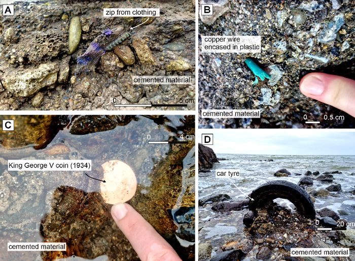
On the West Cumbrian coast of Britain another industry dumped millions of tons of waste into the sea. In the case it was semi-molten ‘slag’ from iron-smelting blast furnaces poured continuously for 130 years until steel-making ended in the 1980s. Coastal erosion has broken up and spread an estimated 27 million cubic metres of slag along a 2 km stretch of beach. Astonishingly this debris has turned into a stratum of anthropogenic conglomerate sufficiently well-bonded to resist storms (Owen, A., MacDonald, J.M. & Brown, D.J 2025. Evidence for a rapid anthropoclastic rock cycle. Geology, v. 53, p. 581–586; DOI: 10.1130/G52895.1). The conglomerate is said by the authors to be a product of ‘anthropoclastic’ processes. Its cementation involves minerals such as goethite, calcite and brucite. Because the conglomerate contains car tyres, metal trouser zips, aluminium ring-pulls from beer cans and even coins lithification has been extremely rapid. One ring-pull has a design that was not used in cans until 1989, so lithification continued in the last 35 years.

Furnace slag ‘floats’ on top of smelted iron and incorporates quartz, clays and other mineral grains in iron ore into anhydrous calcium- and magnesium-rich aluminosilicates. This purification is achieved deliberately by including limestone as a fluxing agent in the furnace feed. The high temperature reactions are similar to those that produce aluminosilicates when cement is manufactured. Like them, slag breaks down in the presence of water to recrystallis in hydrated form to bond the conglomerate. This is much the same manner as concrete ‘sets’ over a few days and weeks to bind together aggregate. There is vastly more ‘anthropoclastic’ rock in concrete buildings and other modern infrastructure. Another example is tarmac that coats millions of kilometres of highway.

See also: Howell, E. 2025. Modern farming has carved away earth faster than during the ice age. Science, v. 388

Is erosion paced by Milankovich cycles?

Both physical and chemical weathering reflects climatic controls. Erosion is effectively climate in continuous action on the Earth’s solid surface through water, air and bodies of ice moving under the influence of gravity. These two major processes on the land surface are immensely complicated. Being the surface part of the rock cycle, they interact with biological processes in the continents’ web of climate-controlled ecosystems. It is self-evident that climate exerts a powerful influence on all terrestrial landforms. But at any place on the Earth’s surface climate changes on a whole spectrum of rates and time scales as reflected by palaeoclimatology. With little room for doubt, so too do weathering and erosion. Yet other forces are at play in the development of landforms. ‘Wearing-down’ of elevated areas removes part of the load that the lithosphere bears, so that the surface rises in deeply eroded terrains. Solids removed as sediments depress the lithosphere where they are deposited in great sedimentary basins. In both cases the lithosphere rises and falls to maintain isostatic balance. On the grandest of scales, plate tectonics operates continuously as well. Its lateral motions force up mountain belts and volcanic chains, and drag apart the lithosphere, events that in themselves change climate at regional levels. Tectonics thereby creates ‘blips’ in long term global climate change. So evidence for links between landform evolution and palaeoclimate is notoriously difficult to pin down, let alone analyse.

The evidence for climate change over the last few million years is astonishingly detailed; so much so that it is possible to detect major global events that took as little as a few decades, such as the Younger Dryas, especially using data from ice cores. The record from ocean-floor sediments is good for changes over hundreds to thousands of years. The triumph of palaeoclimatology is that the last 2.5 Ma of Earth’s history has been proved to have been largely paced by variations in the Earth’s orbit and in the angle of tilt and wobbles of its rotational axis: a topic that Earth-logs has tracked since the start of the 21st century. The record also hints at processes influencing global climate that stem from various processes in the Earth system itself, at irregular but roughly millennial scales. The same cannot be said for the geological record of erosion, for a variety of reasons, foremost being that erosion and sediment transport are rarely continuous in any one place and it is more difficult to date the sedimentary products of erosion than ice cores and laminations in ocean-floor sediments. Nonetheless, a team from the US, Germany, the Netherlands , France and Argentina have tackled this thorny issue on the eastern side of the Andes in Argentina (Fisher, G.B. and 11 others 2023. Milankovitch-paced erosion in the southern Central Andes. Nature Communications, v. 14, 424-439; DOI: 10.1038/s41467-023-36022-0.

Burch Fisher (University of Texas at Austin, USA) and colleagues studied sediments derived from a catchment that drains the Puna Plateau that together with the Altiplano forms the axis of the Central Andes. In the late 19th century the upper reaches of the Rio Iruya were rerouted, which has resulted in its cutting a 100 m deep canyon through Pliocene to Early Pleistocene (6.0 to 1.8 Ma) sediments. The section includes six volcanic ash beds (dated precisely using the zircon U-Pb method) and records nine palaeomagnetic reversals, which together helped to calibrate more closely spaced dating. Their detailed survey used the decay of radioactive isotopes of beryllium and aluminium (10Be and 26Al) in quartz grains that form in the mineral when exposed at the surface to cosmic-ray bombardment. Such cosmogenic radionuclide dating thus records the last time different sediment levels were at the surface, presumably when the sediment was buried, and thus the variation in the rate of sediment supply from erosion of the Rio Iruya catchment since 6 Ma ago.

Measured concentrations (low to high values downwards) of cosmogenic 10Be (turquoise) and 26Al (red) in samples from the Rio Iruya sediment sequence. The higher the value, the longer the layer had resided at the surface; i.e. the slower the erosion rate. (Credit: Fisher et al. Fig 4)

The data from 10Be suggest that erosion rates were consistently high from 6 to 4 Ma, but four times during the later Pliocene and the earliest Pleistocene they slowed dramatically. Each of these episodes occupies downturns in solar warming forced by the 400 ka cycle of orbital eccentricity. The 26Al record confirms this trend. The most likely reason for the slowing of erosion is long-term reductions in rainfall, which Fisher et al have modelled based on Milankovich cycles. However the modelled fluctuations are subtle, suggesting that in the Central Andes at least erosion rates were highly sensitive to climatic fluctuations. Yet the last 400 ka cycle in the record shows no apparent correlation with climate change.  Despite that, astronomical forcing while early Pleistocene oscillations between cooling and warming ramped up does seem to have affected erosion rates based on the cosmogenic dating. The authors attribute this loss of the 400 ka pattern to a kind of swamping effect of dramatically increased erosion rates as the regional climate became more erratic. Whether or not data of this kind will emerge for the more climatically drastic 100 ka cyclicity of the last million years remains to be seen … Anyone who has walked over terrains covered in glacial tills and glaciofluvial gravel beds nearer to the former Late Pleistocene ice sheets can judge the difficulty of such a task.

New dating questions previous ideas about early hominins

The Sterkfontein cave 40 km northwest of Johannesburg in South Africa first sprang to the attention of scientists in 1936, with the discovery there of an adult hominin skull. This showed clear affinities with the discovery 400 km to the SW in 1924 of the fossil skull of a juvenile primate, which Raymond Dart claimed to be ancestral to modern humans, naming it Australopithecus africanus. Sterkfontein has since yielded more than 500 hominin fossils, many of which are Au. africanus.

Limestone cave deposits are difficult to date precisely, unlike sediments that are interbedded with volcanic rocks, the most amenable material being that deposited by water flowing through the cave to form flowstone or speleothem. Using the U-Pb method of radiometric dating yielded an age of between 2.1 to 2.6 Ma for flowstone that cements the breccia in which the Au. africanus fossils occur. Clearly, the flowstone formed after burial so that was a minimum age for them, awaiting the use of a different chronological tool to suggest when burial of the bones took place

The face of an Australopithecus africanus: ‘Mrs Ples’. (Credit University of Zurich)

An almost complete skeleton of another australopithecine found in another part of the Sterkfontein cave system was dated in 2015 by a different approach. This used the decay of 10Be and 26Al isotopes that high-energy cosmic rays produce in quartz grains while they are exposed at the surface. Burial of irradiated sedimentary grains protects them from such bombardment, and the two isotopes  then steadily decay at a known rate. Quartz grains associated with this specimen (fondly known as ‘Little Foot’) turned out to be far older than the flowstone U-Pb age, with a cosmogenic burial age of about 3.7 Ma. Its much greater antiquity prompted scientists to regard ‘Little Foot’ as a different species – Au. prometheus – despite being similar to Au. africanus.

Since that success, much the same team from South Africa, the US and France has been working on sedimentary grains buried with the abundant Au. africanus specimens from Sterkfontein (Granger D.E. et al. 2022. Cosmogenic nuclide dating of Australopithecus at Sterkfontein, South AfricaProceedings of the National Academy of Sciences, v. 119, article e2123516119; DOI: 10.1073/pnas.2123516119). Their newly published efforts show that “Little Foot’s” burial took place between 3.41 and 3.49 Ma, more than a million years earlier than suggested by the flowstone U-Pb dating and just ~200 ka younger than the ‘Little Foot’ skeleton. More surprising is that Au. africanus lived during the same period (3.4 to 3.7 Ma) as did Au. afarensis – the species to which ‘Lucy’ belonged – 3500 km to the north in Ethiopia.

So it is no longer justifiable  to suggest that the first known human species (Homo habilis ~2.3 to 1.65 M) is either a more ‘advanced’ australopithecine or a direct descendant from that genus, for the new dating opens a million-year gap in the history of human evolution. That age range does contain stone tools but no plausible candidates for an australopithecine-human evolutionary connection. One of the most recently suggested link is Au. sediba (see: Another candidate for earliest, direct human ancestor, October 2011; and Australopithecus sediba: is she or is she not a human ancestor? April 2013). The snag with that candidate is that the well-established age (2.0 Ma) of known specimens falls in the middle of the range for H. habilis. The two may have been cohabiters of Africa but are very different.

The million years that separated Au. africanus together with afarensis from H. habilis is the period when the defining character of humans, tool making, evolved. So the hunt is on for hominins associated with stone tools in that huge stratigraphic gap. One of the drawbacks with famous sites, such as the ‘Cradle of Humankind’ that includes Sterkfontein, is that they almost become clichés so that scientists return to them again and again, while the key that they seek may well lie elsewhere.

Balanced boulders and seismic hazard

The seismometer invented by early Chinese engineer Zhang Heng

China has been plagued by natural disasters since the earliest historical writings. Devastating earthquakes have been a particular menace, the first recorded having occurred in 780 BC . During the Han dynasty in 132 CE, polymath Zhang Heng invented an ‘instrument for measuring the seasonal winds and the movements of the Earth’ (Houfeng Didong Yi, for short): the first seismometer. A pendulum mechanism in a large bronze jar activated one of eight dragons corresponding to the eight cardinal and intermediate compass directions (N, NE, E etc.) so that a bronze ball dropped from its mouth to be caught by a corresponding bronze toad. The device took advantage of unstable equilibrium in which a small disturbance will produce a large change: akin to a pencil balanced on its unsharpened end. Modern seismometers exploit the same basic principle of amplification of small motions. The natural world is also full of examples of unstable equilibrium, often the outcome of chemical and physical weathering. Examples are slope instability, materials that are on the brink of changing properties from those of a solid to a liquid state (thixotropic materials – see: Mud, mud, glorious mud August 2020) and rocks in which stress has built almost to the point of brittle failure: earthquakes themselves. But there are natural curiosities that not only express unstable equilibrium but have maintained it long enough to become … curious! Perched boulders, such as glacial erratics and the relics of slow erosion and weathering, are good examples. Seismicity could easily topple them, so that their continued presence signifies that large enough tremors haven’t yet happened.

A precarious boulder in coastal central California (credit: Anna Rood & Dylan Rood, Imperial College London)

Now it has become possible to judge how long their delicate existence has persisted, giving a clue to the long-term seismicity and thus the likely hazard in their vicinity (Rood, A.H. and 10 others 2020. Earthquake Hazard Uncertainties Improved Using Precariously Balanced Rocks. American Geological Union Advances, v. 1, ePDF e2020AV000182; DOI: 10.1029/2020AV000182). Anna Rood and her partner Dylan of Imperial College London, with colleagues from New Zealand, the US and Australia, found seven delicately balanced large boulders of silica-rich sedimentary rock in seismically active, coastal California. They had clearly withstood earthquake ground motions for some time. Using multiple photographs to produce accurate digital 3D renditions and modelling of resistance to shaking and rocking motions, the authors determined each precarious rock’s probable susceptibility to toppling as a result of earthquakes. How long each had withstood tectonic activity shows up from the mass-spectrometric determination of beryllium-10 isotopes produced by cosmic-ray bombardment of the outer layer. Comparing its surface abundance relative to that in the rock’s interior indicates the time since the boulders’ first exposure to cosmic rays. With allowance for former support from surrounding blocks, this gives a useful measure of the survival time of each boulder – its ‘fragility age’.

The boulder data provide a useful means of reducing the uncertainties inherent in conventional seismic hazard assessment, which are based on estimates of the frequency of seismic activity, the magnitude of historic ‘quakes, in most cases over the last few hundred years, and the underlying geology and tectonics. In the study area (near a coastal nuclear power station) the data have narrowed uncertainty down to almost a half that in existing risk models. Moreover, they establish that the highest-magnitude earthquakes to be expected every 10 thousand years (the ‘worst case scenario’) were 27% less than otherwise estimated. This is especially useful for coastal California, where the most threatening faults lie off shore and are less amenable to geological investigation.

See also:  Strange precariously balanced rocks provide earthquake forecasting clues. (SciTech Daily; 1 October 2020)