
People have been mining in Britain since Neolithic farmers opened the famous Grimes Graves in Norfolk – a large area dotted with over 400 pits up to to 13 metres deep. The target was a layer of high quality black flint in a Cretaceous limestone known as The Chalk. Later Bronze Age people in Wales and Cornwall drove mine shafts deeper underground to extract copper and tin ores to make the alloy bronze. The Iron Age added iron ore to the avid search for sources of metals. The production and even export of metals and ores eventually attracted the interest of Rome. Roman invasion in 43 CE during the reign of Claudius annexed most of England and Wales to create the province of Britannia. This lasted until the complete withdrawal of Roman forces around 410 CE. Roman imperialism and civilisation depended partly on lead for plumbing and silver coinage to pay its legionaries. Consequently, an important aspect in Rome’s four-century hegemony was mining, especially for lead ore, as far north as the North Pennines. This littered the surface in mining areas with toxic waste. Silver occurs in lead ore in varying proportions. In the Bronze Age early metallurgists extracted silver from smelted, liquid lead by a process known as cupellation. The molten Pb-Ag alloy is heated in air to a much higher temperature than its melting point, when lead reacts with oxygen to form a solid oxide (PbO) and silver remains molten.
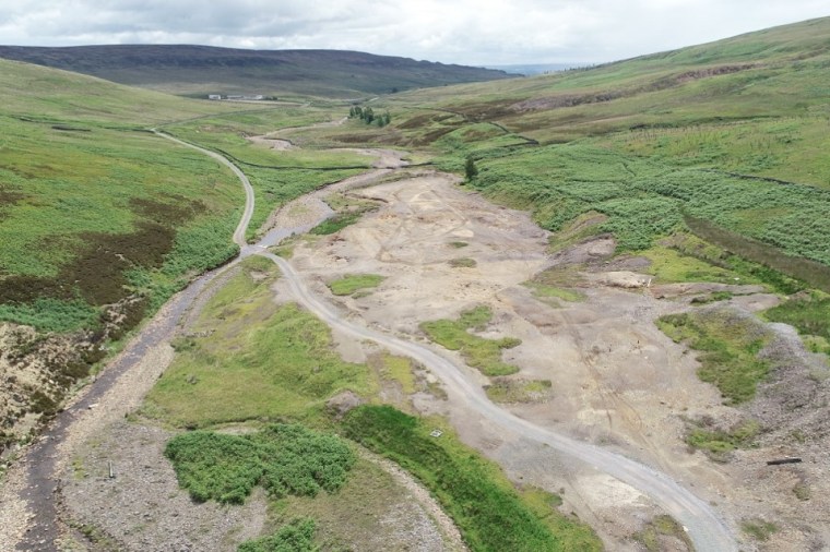
Until recently, historians believed that the fall of the Western Empire brought economic collapse to Britain. Yet archaeologists have revealed that what was originally called the “Dark Ages” (now Early Medieval Period) had a thriving culture among both the remaining Britons and Anglo Saxon immigrants. A means of tracking economic activity is to measure the amount of pollutants from mining waste at successive levels in the alluvium of rivers that flow through orefields. Among the best known in Britain is the North Pennine Orefield of North Yorkshire and County Durham through which substantial rivers flow eastwards, such as the River Ure that flows through the heavily mined valley of Wensleydale. A first attempt at such geochemical archaeology has been made by a British team led by Christopher Loveluck of Nottingham University (Loveluck, C.P. and 10 others 2025. Aldborough and the metals economy of northern England, c. AD 345–1700: a new post-Roman narrative. Antiquity: FirstView, online article; DOI: 10.15184/aqy.2025.10175). Aldborough in North Yorkshire – sited on the Romano-British town of Isurium Brigantum – lies in the Vale of York, a large alluvial plain. The River Ure has deposited sands, silts and muds in the area since the end of the last Ice Age, 11 thousand years ago.
Loveluck et al. extracted a 6 m core from the alluvium on the outskirts of Aldborough, using radiocarbon and optically-stimulated luminescence of quartz grains to calibrate depth to age in the sediments. The base of the core is Mesolithic in age (~6400 years ago) and extends upwards to modern times, apparently in an unbroken sequence. Samples were taken for geochemical analysis every 2 cm through the upper 1.12 m of the core, which spans the Roman occupation (43 to 410 CE), the early medieval (420 to 1066 CE), medieval (1066 to 1540 CE), post-medieval (1540 to 1750 CE) and modern times (1750 CE to present). Each sample was analysed for 56 elements using mass spectrometry; lead, silver, copper, zinc, iron and arsenic being the elements of most interest in this context. Other data gleaned from the sediment are those of pollen, useful in establishing climate and ecological changes. Unfortunately, the metal data begin in 345 CE, three centuries after the Roman invasion, by which time occupation and acculturation were well established. The authors assume that Romans began the mining in the North Pennines. They say nothing about the pre-mining levels of pollution from the upstream orefield nor mining conducted by the Iron Age Brigantes. For this kind of survey, it is absolutely essential that a baseline is established for the pollution levels under purely natural conditions. The team could have analysed sediment from the Mesolithic when purely natural weathering, erosion and transport could safely be assumed, but they seem not to have done that.
The team has emphasised that their data suggest that mining for lead continued and even increased through the ‘Dark Ages’ rather than declining, in an economic ‘slump’ once the Romans left, as previous historians have suggested. Lead pollution continued at roughly the same levels as during the Roman occupation through the Early Medieval Period and then rose to up to three times higher after the late 14th century. The data for silver are different. The Ag data from Aldborough show a large ‘spike’ in 427 to 427 CE. Interestingly this is after the Roman withdrawal. Its level in alluvium then ‘flatlines’ at low abundances until the beginning of the 14th century when again there is a series of ‘booms’. This seems to me to mark sudden spells of coining, after the Romans left perhaps first to ensure a money economy remained possible, and then as a means of funding wars with the French in the 14th century. The authors also found changing iron abundances, which roughly double from low Roman levels to an Early Medieval peak and then fall in the 11th century: a result perhaps of local iron smelting. The overall patterns for zinc and copper differ substantially from those of lead, as does that for arsenic which roughly follows the trend for iron. That might indicate that local iron production was based on pyrite (FeS2) which can contain arsenic at moderate concentrations: pyrite is a common mineral in the ore bodies of the North Pennines’ The paper by Loveluck et al. is worth reading as a first attempt to correlate stratigraphic geochemistry data with episodes in British and, indeed, wider European history. But I think it has several serious flaws, beyond the absence of any pre-Roman geochemical baseline, as noted above. No data are presented for barium (Ba) and fluorine (F) derived from the gangue minerals baryte (BaSO4) and fluorite (CaF2), which outweigh lead and zinc sulfides in North Pennine ore bodies, yet had no use value until the Industrial Revolution. They would have made up a substantial proportion of mine spoil heaps – useful ores would have been picked out before disposal of gangue – whose erosion, comminution and transport would make contributions to downstream deposition of alluvium consistent with the pace of mining. That is: Ba and F data would be far better guides to industrial activity. There is a further difficulty with such surveys in northern Britain. The whole of the upland areas were subjected to repeated glaciation, which would have gathered exposed ore and gangue and dumped it in till, especially in the numerous moraines exposed in valleys such as Wensleydale. Such sources may yield sediment in periods of naturally high erosion during floods. Finally, the movement of sediment downstream is obviously not immediate, especially when waste is disposed in large dumps near mines Therefore phases of active mining may not contribute increased toxic waste far downstream until decades or even centuries later. These factors could easily have been clarified by a baseline study from earlier archaeological periods when mining was unlikely, into which the Aldborough alluvium core penetrates


