A hint of proto-Earth that predates Moon formation by giant impact  

Artist’s impression of the impact of a roughly Mars-size planet with the proto-Earth to form an incandescent cloud, from part of which the Moon formed.

Geochemists have gradually built a model of the proportions of the 92 naturally occurring elements that characterise the Solar System. It is based on systematic chemical analysis of meteorites, especially the ‘stony’ ones. One hypothesis for Earth formation is that the bulk of it chemically resembles a class of meteorites known as C1 carbonaceous chondrites. But there are important deviations between that and reality. For instance the relative proportions of the isotopes of several elements in meteorites have been found to differ. Because nuclei of all the elements and their individual isotopes have been shown to form in supernovae through nucleosynthesis, such instances are known as ‘nucleosynthetic anomalies’. An example is that of the isotopes of potassium (K), which was investigated by a team of geochemists from the Carnegie Institution for Science in Washington DC, USA and the Chengdu University of Technology, China led by Nicole Nie  (Nie, N.X. et al. 2023. Meteorites have inherited nucleosynthetic anomalies of potassium-40 produced in supernovae. Science, v.379, p, 372-376; DOI: 10.1126/science.abn1783).

A measure for the magnitude of this nucleosynthetic anomaly  is the ratio between the abundance in a sample of potassium’s  rarest (40K) and its most common isotope (39K), divided by the ratio in an accepted standard of terrestrial rock. Since isotopically identical samples would yield a value of 1, the result has 1.0 subtracted from it to emphasise anomalies. Samples that are relatively depleted in 40K give negative values, whereas enriched samples give positive values. This measure is signified by ε40K, ε being the Greek letter epsilon. The authors found significant and variable positive anomalies of ε40K in carbonaceous chondrite (CC) meteorites, compared with non-carbonaceous (NC) meteorites. They also found that ε40K data in terrestrial rocks are quite different from those of CC meteorites. Indeed, they suggested that Earth was more likely to have formed from NC meteoritic material. Clearly, there seems to be something seriously amiss with the hypothesis that Earth largely accreted from C1 carbonaceous chondrites.

The correlation between ε40K and ε100Ru in meteorites (EC – enstatite chondrites, OC – ordinary chondrites; CC – carbonaceous chondrites), Earth and a geochemically modelled proto-Earth. Credit: Da Wang et al., Fig 2

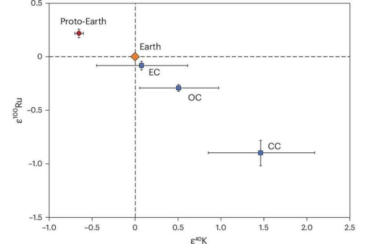
Three of the authors of Nie et al. and other researchers from MIT in Cambridge MA and Scripps Institution of Oceanography in San Diego CA, USA and ETH in Zurich, Switzerland have produced more extensive potassium isotope data to examine Earth’s possible discrepancy with the chondritic Earth hypothesis (Da Wang et al. 2025. Potassium-40 isotopic evidence for an extant pre-giant-impact component of Earth’s mantle. Nature Geoscience, v. 18, online article; DOI: 10.1038/s41561-025-01811-3). To better approximate the bulk Earth’s potassium isotopes they analysed a large number of terrestrial rock samples of all kinds and ages to compare with meteorites of different classes. Meteorites also have variable  nucleosynthetic anomalies for ruthenium-100 (ε100Ru). So, ε40K  and ε100Ru may be useful tracers with regards to Earth’s history. But, for some reason, the research group did not analyse ruthenium isotopes in the terrestrial samples.

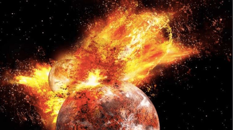
Most samples of igneous rocks from different kinds of Phanerozoic volcanic provinces (continental flood basalts, island arcs, and ocean ridge basalts) showed no evidence of anomalous potassium isotopes. However, some young ocean-island basalts from Réunion and Hawaii showed considerable depletion in 40K. A quarter of early Archaean (>3.5 Ga) metamorphosed basaltic rocks from greenstone belts also showed clear 40K depletion. Yet no samples of granitic crust of similar antiquity showed any anomaly and nor did marine sediments derived from younger continental crust. Even the oldest known minerals – zircon grains from Jack Hills Western Australia – showed no anomalies. The authors suggest that both the anomalous groups of young and very ancient terrestrial basalts show signs that their parent magmas may have formed by partial mantle melting of substantial bodies of the relics of proto-Earth. To account for this anomalous mantle Da Wang et al. suggest from modelling that proto-Earths 40K deficit may have arisen from early accretion of meteorites with that property. Later addition of material more enriched with that isotope, perhaps as meteorites or through the impact with a smaller planet that triggered Moon-formation. That cataclysm was so huge that it left the Earth depleted in ‘volatile’ elements and in a semi-molten state. It reset Earth geochemistry as a result of several processes including the mixing induced by very large-scale melting. No radiometric dating has penetrated that far back in Earth history. However, in February 2004, Alex Halliday used evidence from several isotopic systems (Pb, Xe, Sr, W) to show that about two thirds of Earth’s final mass may have accreted in the first 11 to 40 Ma of its history.

Curiously, none of the hundreds of meteorites that have been geochemically analysed show the level of 40K depletion in the terrestrial samples. Nicole Nie has comments, “… our study shows that the current meteorite inventory is not complete, and there is much more to learn about where our planet came from.”

I’m persuaded to write this by ‘Piso Mojado’. And today – 23rd October – is the anniversary of the Creation of Earth, Life and the Universe in 4004 BCE, according to Archbishop James Ussher (1581-1656) by biblical reckoning, which always tickles me!

See also: Chu, J. 2025. Geologists discover the first evidence of 4.5-billion-year-old “proto Earth”. MIT News, 14 October 2025.

The final closure of the Iapetus Ocean

A symposium hosted by the Royal Society in 1965 aimed at resurrecting Alfred Wegener’s hypothesis of continental drift. During the half century since Wegener made his proposal in 1915, it had been studiously ignored by most geologists. The majority had bumbled along with the fixist ideology of their Victorian predecessors. The symposium launched what can only be regarded as a revolution in the Earth Sciences. In the three years following the symposium, the basic elements of plate tectonics had emerged from a flurry of papers, mainly centred on geophysical evidence. Geology itself became part of this cause célèbre through young scientists eager to make a name for themselves. The geological history of Britain, together with that of the eastern North America, became beneficiaries only four years after the Royal Society meeting (Dewey, J. 1969. Evolution of the Appalachian/Caledonian Orogen. Nature 222, 124–129; DOI: 10.1038/222124a0).

In Britain John Dewey, like a few other geologists, saw plate theory as key to understanding the many peculiarities revealed by geological structure, igneous activity and stratigraphy of the early Palaeozoic. These included very different Cambrian and Ordovician fossil assemblages in Scotland and Wales, now only a few hundred kilometres apart. The Cambro-Ordovician of NW Scotland was bounded to the SE by a belt of highly deformed and metamorphosed Proterozoic to Ordovician sediments and volcanics forming the Scottish Highlands. That was terminated to the SE by a gigantic fault zone containing slivers of possible oceanic lithosphere. The contorted and ‘shuffled’ Ordovician and Silurian sediments of the Southern Uplands of Scotland. The oldest strata seemed to have ocean-floor affinities, being deposited on another sliver of ophiolites.  A few tens of km south of that there was a very different Lower Palaeozoic stratigraphy in the Lake District of northern England. It included volcanic rocks with affinities to those of modern island arcs. A gap covered by only mildly deformed later Palaeozoic shelf and terrestrial sediments, dotted by inliers of Proterozoic sediments and volcanics separated the Lake District from yet another Lower Palaeozoic assembly of arc volcanics and marine sediments in Wales. Intervening in Anglesey was another Proterozoic block of deformed sediments that also included ophiolites.

Dewey’s tectonic assessment from this geological hodge-podge, which had made Britain irresistible to geologists through the 19th and early 20th centuries, was that it had resulted from blocks of crust (terranes), once separated by thousands of kilometres, being driven into each other. Britain was thus formed by the evolution and eventual destruction of an early Palaeozoic ocean, Iapetus: a product of plate tectonics. Scotland had a fundamentally different history from England and Wales; the unification of several terranes having taken over 150 Ma of diverse tectonic processes. Dewey concluded that the line of final convergence lay at a now dead, major subduction zone – the Iapetus Suture – roughly beneath the Solway Firth. During the 56 years since Dewey’s seminal paper on the Caledonian-Appalachian Orogeny details and modifications have been added at a rate of around one to two publications per year. The latest seeks to date when and where the accretion of 6 or 7 terranes was finally completed (Waldron, J.W.F. et al. 2025. Is Britain divided by an Acadian suture?  Geology, v. 53, p. 847–852; DOI: 10.1130/G53431.1).

Kernel density plots – smoothed versions of histograms – of detrital zircon ages in Silurian and Devonian sandstones from Wales. The bracketed words are stratigraphic epochs. Credit: Waldron et al. 2025, Fig 3A

John Waldron and colleagues from the University of Alberta and Acadia University in Canada and the British Geological Survey addressed this issue by extracting zircons from four late Silurian and early Devonian sandstones in North and South Wales. These sediments had been deposited between 433 and 393 Ma ago at the southernmost edge of the British Caledonide terrane assemblage towards the end of terrane assembly. The team dated roughly 250 zircons from each sandstone using the 207Pb/206Pb and 206Pb/238U methods. Each produced a range of ages, presumed to be those of igneous rocks from whose magma the zircon grains had crystallised. These data are expressed as plots of probable frequency against age.  Each pattern of ages is assumed to be a ‘fingerprint’ for the continental crust from which the zircons were eroded and transported to their resting place in their host sediment. In this case, the researchers were hoping to see signs of continental crust from the other side of the Caledonian orogen; i.e. from the Precambrian basement of the Laurentia continent.

The three late-Silurian sediments showed distinct zircon-age peaks around 600 Ma and a spread of smaller peaks extending to 2.2 Ga. This tallied with a sediment source in Africa, from which the southernmost Caledonian terrane was said to have split and moved northwards.  The Devonian sediment lacked signs of such an African ‘heritage’ but had a prominent age peak at about 1.0 Ga, absent from the Welsh Silurian sediments.  Not only is this a sign of different sediment provenance but closely follows the known age of a widespread magmatic pulse in the Laurentian continent. So, sediment transport from the opposite side of the Iapetus Ocean across the entire Caledonian orogenic belt was only possible after the end of the Silurian Period at around 410 Ma. There must have been an intervening barrier to sediment movement from Laurentia before that, such as deep ocean water further north. Previous studies from more northern Caledonian terranes show that Laurentian zircons arrived in the Southern Uplands of Scotland and the English Lake District around 432 Ma in the mid-Silurian. Waldron et al. suggest, on these grounds that the suture marking the final closure of the Iapetus Ocean lies between the English Lake District and Anglesey, rather than beneath the Solway. They hint that the late-Silurian to early Devonian granite magmatism that permeated the northern parts of the Caledonian-Appalachian orogen formed above northward subduction of the last relics of Iapetus, which presaged widespread crustal thickening known as the Acadian orogeny in North America.

Readers interested in this episode of Earth history should download Waldron et al.’s paper for its excellent graphics, which cannot be reproduced adequately here.

Gravity survey reveals signs of Archaean tectonics in Canadian Shield

Much of the Archaean Eon is represented by cratons, which occur at the core of continental parts of tectonic plates. Having low geothermal heat flow they are the most rigid parts of the continental crust.  The Superior Craton is an area that makes up much of the eastern part of the Canadian Shield, and formed during the Late Archaean from ~4.3 to 2.6 billion years (Ga) ago. Covering an area in excess of 1.5 million km2, it is the world’s largest craton. One of its most intensely studied components is the Abitibi Terrane, which hosts many mines. A granite-greenstone terrain, it consists of volcano-sedimentary supracrustal rocks in several typically linear greenstone belts separated by areas of mainly intrusive granitic bodies. Many Archaean terrains show much the same ‘stripey’ aspect on the grand scale. Greenstone belts are dominated by metamorphosed basaltic volcanic rock, together with lesser proportions of ultramafic lavas and intrusions, and overlying metasedimentary rocks, also of Archaean age. Various hypotheses have been suggested for the formation of granite-greenstone terrains, the latest turning to a process of ‘sagduction’. However the relative flat nature of cratonic areas tells geologists little about their deeper parts. They tend to have resisted large-scale later deformation by their very nature, so none have been tilted or wholly obducted onto other such stable crustal masses during later collisional tectonic processes. Geophysics does offer insights however, using seismic profiling, geomagnetic and gravity surveys.

The Geological Survey of Canada has produced masses of geophysical data as a means of coping with the vast size and logistical challenges of the Canadian Shield. Recently five Canadian geoscientists have used gravity data from the Canadian Geodetic Survey to model the deep crust beneath the huge Abitibi granite-greenstone terrain, specifically addressing variations in its density in three dimensions. They also used cross sections produced by seismic reflection and refraction data along 2-D survey lines (Galley, C. et al. 2025. Archean rifts and triple-junctions revealed by gravity modeling of the southern Superior Craton. Nature Communications, v. 16, article 8872; DOI: 10.1038/s41467-025-63931-z). The group found that entirely new insights emerge from the variation in crustal density down to its base at the Moho (Mohorovičić discontinuity). These data show large linear bulges in the Moho separated by broad zones of thicker crust.

Geology of the Abitibi Terrane (upper),; Depth to the Moho beneath the Abitibi Terrane with rifts and VMS deposits superimposed (lower). Credit: After Galley et al. Figs 1 and 5.

Galley et al. suggest that the zones are former sites of lithospheric extensional tectonics and crustal thinning: rifts from which ultramafic to mafic magmas emerged. They consider them to be akin to modern mid-ocean and continental rifts. Most of the rifts roughly parallel the trend of the greenstone belts and the large, long-lived faults that run west to east across the Abitibi Terrain. This suggests that rifts formed under the more ductile lithospheric condition of the Neoarchaean set the gross fabric of the granites and greenstones. Moreover, there are signs of two triple junctions where three rifts converge: fundamental features of modern plate tectonics. However, both rifts and junctions are on a smaller scale than those active at present. The rift patterns suggest plate tectonics in miniature, perhaps indicative of more vigorous mantle convection during the Archaean Eon.

There is an interesting spin-off. The Abitibi Terrane is rich in a variety of mineral resources, especially volcanic massive-sulfide deposits (VMS). Most of them are associated with the suggested rift zones. Such deposits form through sea-floor hydrothermal processes, which Archaean rifting and triple junctions would have focused to generate clusters of ‘black smokers’ precipitating large amounts of metal sulfides. Galley et al’s work is set to be applied to other large cratons, including those that formed earlier in the Archaean: the Pilbara and Kaapvaal cratons of Australia and South Africa. That could yield better insights into earlier tectonic processes and test some of the hypotheses proposed for them

See also: Archaean Rifts, Triple Junctions Mapped via Gravity Modeling. Scienmag, 6 October 2025