Sea-level rise following a Snowball Earth

The Cryogenian Period (850 to 635 Ma) of the Neoproterozoic is named for the intense glacial episodes recorded in strata of that age. There were two that palaeomagnetism  in glaciogenic sedimentary rocks indicates that ice covered all of the continents including those in the tropics, and a third, less extreme one. These episodes, when documented in the 1990s, became dubbed, aptly enough, as ‘Snowball Earth’ events. But evidence for frigidity does not pervade the entire Cryogenian, the glacial events being separated by long periods with no sign anywhere of tillites or glaciomarine diamictites shed by floating ice. Each Snowball Earth episode is everywhere overlain by thick carbonate deposits indicating clear, shallow seas and a massive supply of calcium and magnesium ions to seawater. The geochemical change is a clear indicator of intense chemical weathering of the exposed continents. The combination of Ca and Mg with carbonate ions likewise suggests an atmosphere rich in carbon dioxide. For frigidity episodically to have pervaded the entire planet indicates a distinct dearth of the greenhouse gas in the atmosphere during those events. The likely explanation for Snowball Earths is one of booms in the abundance of minute marine organisms, perhaps a consequence of the high phosphorus levels in the oceans during the Neoproterozoic when seawater was alkaline. The carbon-isotope record suggests that there were periodic, massive bursts of organic matter that would have drawn down atmospheric CO2, which coincide with the evidence for global frigidity, although marine life continued to flourish.

Artist’s impression of the glacial maximum of a Snowball Earth event (Source: NASA)

Under such ice-bound conditions the build-up of continental glaciers would have resulted in huge falls in global sea level, far exceeding the 150 m recorded during some late-Pleistocene glacial maxima. The end of each Snowball Earth would have led to equally dramatic rises and continental flooding. Such scenarios are well accepted to have occurred when accumulation of volcanic CO2 during full ice cover reached a threshold of global warming potential that could overcome the reflection of solar radiation by the high albedo of ice extending to the tropics. That threshold has been estimated to have been between 400 to 500 times the CO2 content of the atmosphere at present. Yet it has taken an intricate analysis of sedimentary structures that are commonplace in marine sediments of any age – ripple marks – to quantify the pace of sea-level rise at the end of a Snowball Earth event (Myrow, P.M. et al. 2018. Rapid sea level rise in the aftermath of a Neoproterozoic snowball Earth. Science, v. 360, p. 649-651; doi:10.1126/science.aap8612).

The Elatina Formation of South Australia, deposited during the Marinoan (~635 Ma) glaciation, is famous for the intricacy of its sedimentary structures especially in the clastic sedimentary rocks beneath the cap carbonate that marks the end of glacial conditions. Among them are laminated silts and fine sands that were originally thought to be the equivalent of modern varved sediments that form annually as lakes or shallow seas freeze over and then melt with the seasons. Since they contain ripple marks the laminates of the Elatina Formation clearly formed as a result of current flow and wave action – the sea surface was therefore ice free while these sediments accumulated. Careful study of the larger ripples, which are asymmetrical, shows that current-flow directions periodically reversed, suggesting that they formed as a result of tidal flows during the bi-monthly cycle of spring and neap tides in marine deltas. Data from experiments in wave tanks shows that the shapes (expressed as their amplitude to wavelength ratio) of wave ripples depend on the orbital motion of water waves at different depths. The smaller ripples are of this kind. So Myrow and colleagues have been able to tease out a time sequence from the tidal ripples and also signs of any variation in the water depth at which the smaller wave ripples formed.

Ripples on a bedding surface in the Elatina Formation, South Australia. They formed under the influence of tidal current flow. (Credit, University of Guelph, https://atrium.lib.uoguelph.ca/xmlui/handle/10214/9367?show=full)

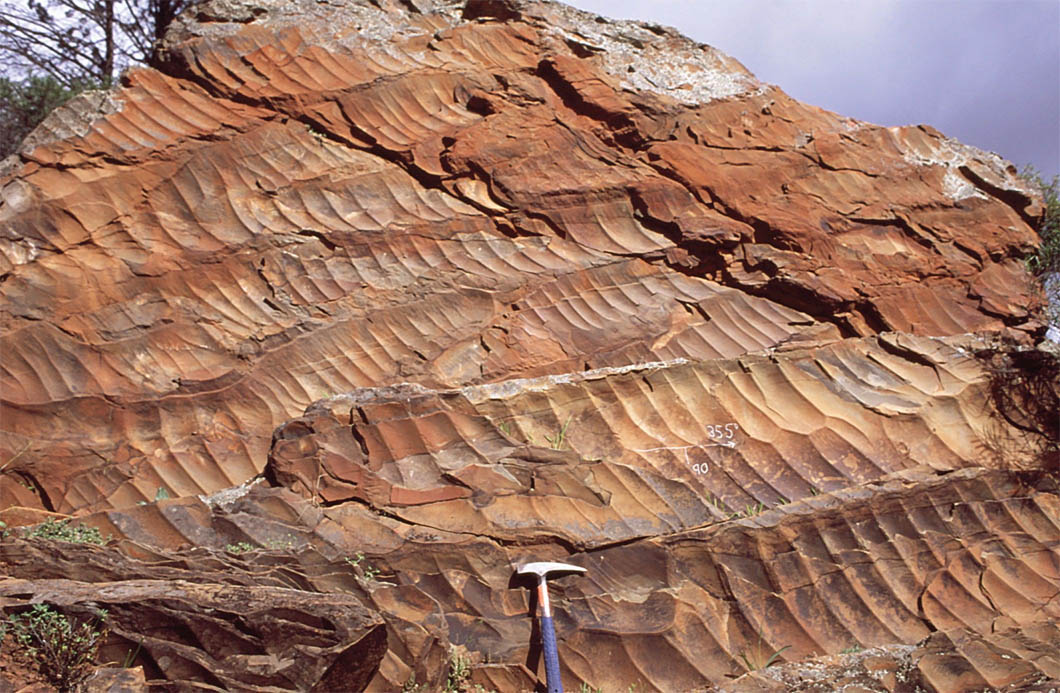
Just over 9 metres of the tidal laminate sequence that escaped any erosion was deposited in about 60 years, giving a sedimentation rate of 27 cm per year. This is extremely high by comparison with those in any modern marine basins, probably reflecting the sediment-charged waters during a period of massive glacial melting. Throughout the full 27 m sequence smaller, wave ripples consistently show that water depth remained between 9 to 16 m for about a century. Over such a short time interval any tectonic subsidence or sag due to sediment load would have been minuscule. So sea-level rise kept pace with deposition; i.e. at the same rate of 27 cm per year. That is at least five times faster than during any of the Pleistocene deglaciations and about a hundred times faster than sea-level rise today that is caused by melting of the Greenland and Antarctic ice caps and thermal expansion of ocean water due to global warming. It has been estimated that the Marinoan ice sheets lowered global sea level by between 1.0 to 1.5 km – ten times more than in the last Ice Age – so deglaciation to the conditions of the cap carbonates, shallow, clear seas at around 50°C, would have taken about 6,000 years at the measured rate.

To read more on the Snowball Earth hypothesis and other early glacial epochs click here

A fully revised edition of Steve Drury’s book Stepping Stones: The Making of Our Home World can now be downloaded as a free eBook

Late Palaeozoic glacial features in Chad

The longest and most extreme glacial epoch during the Phanerozoic took place between 360 and 260 Ma ago, when it dominated the Carboniferous and Permian sedimentary sequences across the planet. On continents that lay athwart the Equator during these times, sedimentation was characterised by cycles between shallow marine and terrestrial conditions. These are epitomised by the recurring ‘Coal-Measure’ cyclothem of, from bottom to top: open-sea limestone; near-shore marine mudstone; riverine sandstone; coal formed in swamps. This sequence represents a rapid rise in sea level as ice sheets melted, sustained during an interglacial episode and then falling sea level as ice once again accumulated on land to culminate in a glacial maximum when coal formed in coastal mires. During the Late Palaeozoic Era a single supercontinent extended from pole to pole. The break-up of Pangaea was charted by Alfred Wegener in 1912, partly by his using glacial deposits and ice-gouged striations on the southern continents. With the present widely separated configuration of major landmasses glacial sediments and the directions of inferred ice movements could only be reconciled by reassembling Africa, India, South America, Antarctica and Australia in the form of a single, congruent southern continent that he called Gondwanaland. In Wegener’s reconstruction the glacial features massed together on Gondwanaland with the striations radiating outwards from what would then have been the centre of a huge ice cap.

There are many localities on the present southern continents where such striations can be seen on the surface of peneplains etched into older rocks that underlie Carboniferous to Permian tillites, but later erosion has removed the continuity of the original glacial landscape. There are, however, some parts of central Africa where it is preserved. By using the high-resolution satellite images (with pixels as small as 1 m square) that are mosaiced together in Google Earth, Daniel Paul Le Heron of Royal Holloway, University of London has revealed a series of 1 to 12 km wide sinuous belts in a 6000 km2 area of eastern Chad that are superimposed unconformably on pre-Carboniferous strata (Le Heron, D.P. 2018. An exhumed Paleozoic glacial landscape in Chad. Geology, v.46(1), p. 91-94; doi:10.1130/G39510.1). They comprise irregular tracts of sandstone to the south of a major Carboniferous sedimentary basin. Zooming in to them (try using 17.5° N 22.25°E as a search term in Google Earth) reveals surfaces dominated by wavy, roughly parallel lines. Le Heron interprets these as mega-scale glacial lineations, formed by ice flow across underlying soft Carboniferous glacial sediments as seen in modern glacial till landforms in Canada. In places they rest unconformably on older rocks, sometimes standing above the level of the sandstone plateaux as relics of what may have been nunataks. There are even signs of elliptical drumlins.

An oblique Google Earth view looking to the south-east shows mega-scale glacial lineations from a glacial flow way in eastern Chad. The lower-right quadrant shows the unconformity atop older bedded strata that are dipping to the west. Click on the image to see a full resolution view. (Credit: Google Earth)

Glacial tillites and glaciofluvial sediments of Late Palaeozoic age are common across the Sahara and in the Sahelian belt, but in areas as remote as those in eastern Chad. So a systematic survey using the resolving power of Google Earth may well yield yet more examples. It is tedious work in such vast areas, unless, of course, one bears in mind Alfred Wegener, the founder of the hypothesis of continental drift and ‘Big’ Earth Science as a whole, who would have been gleeful at the opportunity.

A fully revised edition of Steve Drury’s book Stepping Stones: The Making of Our Home World can now be downloaded as a free eBook

Neanderthals on the BBC

Since it began in 2000 Earth-Pages News has been covering the emergent science concerning the Neanderthals. To say that it has been a fertile field would be a considerable understatement, and I am certain that it will continue to be so. The first EPN item to mention them concerned the British Channel 4 TV documentary Neanderthals. In it I quoted Steve Jones FRS, former Head of the Department of Genetics, Evolution and Environment at University College London, who is always good for a humorous take on his science, and much more besides. ‘If you met an unwashed Cro Magnon dressed in a business suit on the Underground, you would probably change seats.  If you met a similarly garbed Neanderthal, you would undoubtedly change trains’. That they had the build of world-champion freestyle wrestlers, beetling brows and extremely large noses was illustrated in the programme by reconstructions based on their skeletal remains; yes, they did look  dangerous. But Jones’s theory is put to the test with a suitably attired actor made up as a Neanderthal man in new two-part series on BBC2, Neanderthals – Meet Your Ancestors (follow the link to watch the first programme – you need to create an account at BBC iPlayer and claim that you do have a British TV licence). Some commuters did give the chap a slightly worried glance, but there was not a rush for the doors. Ella Al-Shamahi, one of the presenters, even commented that some of her friends may well have actively sought a date with him! He certainly did not seem out of place in cosmopolitan London, and the same might be said for a cattle auction in rural Cumbria. On the New York subway he would undoubtedly have been ignored. Steve Jones was wrong!

An actor made-up to resemble a Neanderthal man in a business suit traveling on the London Underground. (Source: screen-grab from BBC2 Neanderthals – Meet Your Ancestors)

We now know that the majority of people who live on the planet today have Neanderthal segments in their genome. So between 80 and 30 ka ago to dally with Neanderthals and vice versa was as acceptable as it might be today, if they were around; probably more so, considering the amount of their DNA that is retained 2000 generations after the last possible contact. Most of the discoveries concerning Neanderthals that EPN has covered over the last 17 years are used by the two programmes to arrive at the best concept to date of just who Neanderthals were and what they were able to do.

The first episode focuses on the use of skeletal remains to visualise male and female Neanderthals, using digital techniques of forensic face and body reconstruction. Over several hundred thousand years their physiology had adapted to the fluctuating conditions of western Asia and Europe, including repeated cold episodes that ranged from full glacials to interstadials. They had also adapted to forest ecosystems where hunting would have relied on ambushing prey. Their build was suited to bursts on sprinting, probably faster than Usain Bolt could manage at his best. But they were not built for the kind of endurance needed by evolving modern humans in Africa to chase down prey in savannah scrub until they succumb to heat exhaustion. Interestingly, the right, upper-arm bones of male Neanderthals are more robust than those on the left, muscle attachment scars revealing that in life they developed large biceps, probably to use spears in powerful upward lunges into the underside of large prey, such as mammoths and aurochs. They were close-combat experts and carry the signs of injury that every such hunt would have risked. However, the series goes beyond reconstruction, by using the power of CGI motion-capture techniques developed for modern animated films and games. Actors perform the moves, and are morphed to accommodate Neanderthal physique and probable gait in the resulting action sequences – fearsomely and convincingly realistic. Analysis of a single complete hyoid bone (the hard component of the ‘voice box’ and ‘Adam’s Apple’) digitally inserted into reconstruction of the Neanderthal neck, and digital reconstruction of their possible vocal range results in demonstration of how close to human pronunciation they could have been, albeit with a pronounced distortion of the vowel Aah but almost indistinguishable for other vowels. Their faces were capable of much the same range of expressions as ours.

The second episode, available on BBC iPlayer after Sunday 20 May 2018, focuses on the genetic relations between us and Neanderthals. We gained both advantages and sets-back. It also uses what evidence there is to investigate just how like us they were in their social and intellectual behaviour. It seems they were doing OK in the grim climatic scenario of the run-up to the last glacial maximum, but succumbed to extinction during the ten thousand years following the permanent entry of anatomically modern humans into Europe and western Asia after 40 ka. Why did that happen? Every human outside  sub-Saharan Africa contains Neanderthal genes: on average about 2%. Yet each of us contains a different set, so that up to 70% of the full Neanderthal genome remains in humanity as a whole. Is it possible that they could be reconstructed? Crucially, should that ever be attempted it would pose a huge moral dilemma.

To read more on the evolutionary relationships between modern humans and Neanderthals click here.

A fully revised edition of Steve Drury’s book Stepping Stones: The Making of Our Home World can now be downloaded as a free eBook

Clear signs of a hominin presence on the Philippines at around 700 ka

For over half a century the presence of crude stone tools on several SE Asian islands, such as Flores and Sulawesi in Indonesia and Luzon in the Philippines, have hinted at their colonisation by Asian Homo erectus. Hominin fossils have yet to be exhumed, outside of Flores (Homo floresiensis) and dating the earlier finds has been imprecise, but evidence continues to accumulate. As regards the Philippines, the earliest hominin fossil is a modern human toe bone dated at 66.7 ka. Another curious feature of these isolated parts of what might be termed  ’Wallacea’, on broader floral and faunal grounds, is the presence in the Pleistocene fossil record of large mammals, or at least dwarfed species of megafauna found in mainland Asia. These include elephants, rhinos and deer.

Topography of the Philippines, showing location of the Kalinga site. Palest blue sea would have been above sea level during glacial maxima. At such times Borneo would have been part of Sundaland – linked to mainland Asia (credit: Wikipedia)

A large team, with members from France, Philippines, Australia, Spain, Germany, Holland, Spain and Greece, has been excavating a tool- and fossil-rich site in thick alluvium at Kalinga in northern Luzon since 2014 (Ingicco, T. and 22 others 2018. Earliest known hominin activity in the Philippines by 709 thousand years ago. Nature, published online). It occurs in an erosional channel filled with mud. Stone artefacts comprise 56 flakes, hammer stone and cores, the tools being crude – a common feature of the Asian H. erectus lithic culture, unlike that in Africa and Europe. As well as fragments of other animals, the site is notable for a 75% complete, but disarticulated, skeleton of a rhinoceros scattered over a small area. That in itself suggests that the beast may have been butchered, and is confirmed by cut marks and signs of smashing on several of the bones. Uranium-thorium dating of one of the animal’s teeth (709±68 ka) and sediment grains from above and below the fossiliferous unit by electron-spin resonance (701±70 and 727±30 ka respectively) confirms the great antiquity of the site. Dating of volcanic plagioclase crystals from sediments by the 40Ar/39Ar method yields even older dates around 1 Ma, but the crystals may have been washed for older volcanic ash deposits.

It seems beyond doubt that early hominins, possibly H. erectus, colonised Luzon some 700 ka ago, yet, according to the authors, ‘it still seems too farfetched to suggest that H. erectus, or another unknown Pleistocene ancestral candidate … were able to construct some sort of simple watercraft and deliberately cross sea barriers’. That seems to be pushing caution a little too far. Do the authors not believe their own – to me compelling – evidence and analyses? But the paper spent a year in review, so maybe they came up against a singularly pernickety referee (three are named but one remains anonymous). Presumably, if a hominin fossil turns up during on-going excavations, that would change everything apart from the question, ‘Did they walk, swim or navigate?’ Luzon and the Philippines archipelago as a whole are surrounded by sea shallow enough for them to have been a single landmass during a glacial maximum when sea level was around 100 m lower than at present. At such a juncture a less than 20 km sea journey would have separated the Philippines from Borneo, then part of a vast area of lowland to the SW (Sundaland) that was connected to the Asian mainland.

A fully revised edition of Steve Drury’s book Stepping Stones: The Making of Our Home World can now be downloaded as a free eBook

Mystery of upside-down dinosaurs resolved

Remains of ankylosaurs, a popular family of heavily armoured dinosaurs, occur in sedimentary sequences that range in age from early Jurassic to the close of the Cretaceous. Their defences seem almost impregnable, being constructed of thick, fused scales, often bearing formidable spines, which covered them completely. They bore a crude resemblance to modern armadillos apart from the fact that they were unable to roll-up defensively. In some species the rigid tail bears a large, knob of scale tissue. At up to 3 m long, were the tail to be swung it would have packed bone-cracking momentum. Interestingly, to a poorly sighted predator the club may have been mistaken for the animal’s head at the end of a long neck, so perhaps it lured a potential assailant within range of its devastating power. The largest ankylosaur, from the Cretaceous of western Canada, was the size of a small bus, up to 8m long, 1.5 m wide, standing 1.7 m high and weighing in at around 5 to 8 t. Such dimensions would have made it almost impossible to be bitten, even by the largest predatory dinosaurs, and difficult to turn over. Their teeth show that ankylosaurs were herbivorous, and their somewhat bulbous bodies almost certainly contained a massive digestion system.

Polski: JuraPark Bałtów - Park Dinozaurów - An...
Recfonstruction of Ankylosaurus at the JuraPark Bałtówin Poland (credit: Wikipedia)

The mystery lies in the fact that most ankylosaur fossils are found lying on their backs. Early dinosaur aficionados suggested a tendency for the lumbering beasts to tumble down slopes and become stranded on their backs, so to die miserably. Such clumsiness is hardly a positive characteristic of evolutionary fitness for such a long-lived group, and, besides, the sedimentary formations in which they are found indicate very gentle slopes. So, were they flipped by dextrous predators, as imagined in some early films purporting to look to the distant past? Probably not, for most well preserved fossils show no sign of bites or gnawing. From a study of 36 late-Cretaceous ankylosaurs from Alberta four Canadian and US palaeontologists (Mallon, J.C. et al. 2018. A “bloat-and-float” taphonomic model best explains the upside-down preservation of ankylosaurs. Palaeogeography, Palaeoclimatology, Palaeoecology, v. 497, p. 117-127; doi:10.1016/j.palaeo.2018.02.010 support the idea of their carcases or even living animals having been picked up by flood waters when their high centre of gravity would have flipped them upside down. Bloating through decay might then allow them to be transported large distances. Unsurprisingly, their conclusions rest on model simulations.